GREYSTONES FARM BOURTON ON THE-WATER …
14
GREYSTONES F ARM BOURTON-ON-THE-W ATER GLOUCESTERSHIRE ARCHAEOLOGICAL EVALUATION JUNE 2009 For GLOUCESTERSHIRE WILDLIFE TRUST CA PROJECT: 2813 CA REPORT: 09085
Transcript of GREYSTONES FARM BOURTON ON THE-WATER …

GREYSTONES FARM BOURTON-ON-THE-WATER
GLOUCESTERSHIRE
ARCHAEOLOGICAL EVALUATION
JUNE 2009
For
GLOUCESTERSHIRE WILDLIFE TRUST
CA PROJECT: 2813 CA REPORT: 09085

GREYSTONES FARM BOURTON-ON-THE-WATER
GLOUCESTERSHIRE
ARCHAEOLOGICAL EVALUATION
CA PROJECT: 2813 CA REPORT: 09085
prepared by Philippa Mitcheson, Project Supervisor
date 3 June 2009
checked by Richard Young, Project Manager
date 9 June 2009
approved by Simon Cox, Head of Fieldwork
signed
date 11 June 2009
issue 01
This report is confidential to the client. Cotswold Archaeology accepts no responsibility or liability to any third party to whom this report, or any part of it, is made known. Any such party relies upon this report entirely
at their own risk. No part of this report may be reproduced by any means without permission.
© Cotswold Archaeology Building 11, Kemble Enterprise Park, Kemble, Cirencester, Gloucestershire, GL7 6BQ
Tel. 01285 771022 Fax. 01285 771033 E-mail: [email protected]

© Cotswold Archaeology
1
Greystones Farm, Greystones Lane, Bourton-on-the-Water, Gloucestershire: Archaeological Evaluation
CONTENTS
SUMMARY........................................................................................................................2
1. INTRODUCTION ................................................................................................. 3
2. RESULTS ............................................................................................................ 5
3. DISCUSSION....................................................................................................... 6
4. CA PROJECT TEAM ........................................................................................... 7
5. REFERENCES .................................................................................................... 7
APPENDIX A: CONTEXT DESCRIPTIONS ..................................................................... 8 APPENDIX B: THE FINDS ............................................................................................... 8 APPENDIX C: OASIS REPORT FORM............................................................................ 9
LIST OF ILLUSTRATIONS Fig. 1 Site location plan (1:25,000)
Fig. 2 Test Pit location plan (1:1250)
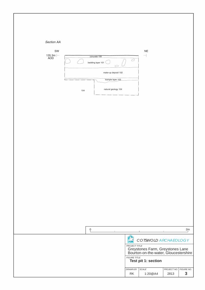
Fig. 3 Test Pit 1: section (1:20)

© Cotswold Archaeology
2
Greystones Farm, Greystones Lane, Bourton-on-the-Water, Gloucestershire: Archaeological Evaluation
SUMMARY
Project Name: Greystones Farm
Location: Bourton-on-the-Water, Gloucestershire
NGR: SP 1730 2088
Type: Evaluation
Date: 12-14 May 2009
SMC: HSD9/2/11091
Location of Archive: To be deposited with Corinium Museum
Site Code: GSF 09
An archaeological evaluation was undertaken by Cotswold Archaeology in May 2009 at the
request of Gloucestershire Wildlife Trust at Greystones Farm, Bourton-on-the-Water,
Gloucestershire. Three test pits were excavated.
Despite the archaeological potential of the development area no archaeologically significant
features or deposits were identified in any of the test pits. In two of the test pits the natural
substrate had been truncated during the construction of modern calving pens and the
insertion of a concrete surface. In the third test pit the presence of an in situ layer associated
with 18th and 19th-century farmyard activity demonstrated that the insertion of the concrete
surface had not truncated the natural substrate in at least one area. The substrate was
encountered between 0.34m and 0.62m below present ground level. Previous evaluations at
the farm have identified archaeological features cut through natural geology between 0.6m
and 0.9m below present ground level so it is likely that any features present would still be
visible.

© Cotswold Archaeology
3
Greystones Farm, Greystones Lane, Bourton-on-the-Water, Gloucestershire: Archaeological Evaluation
1. INTRODUCTION
1.1 In May 2009 Cotswold Archaeology (CA) carried out an archaeological evaluation
for Gloucestershire Wildlife Trust at Greystones Farm, Bourton-on-the-Water,
Gloucestershire (centred on NGR: SP 1730 2088; Fig. 1). The evaluation was
undertaken to accompany an application for Scheduled Monument Consent (ref.
HSD 9/2/11091) for the construction of a barn within the footprint of an existing
disused dairy along with alterations to the heifer shed and main cattle shed and the
installation of a water pipe on the same property. The evaluation was carried out in
accordance with Class 7 of the Ancient Monuments (Class Consents) Order 1994.
1.2 The evaluation was carried out in accordance with a detailed Written Scheme of
Investigation (WSI) produced by CA (2009) and approved by Melanie Barge,
Inspector of Ancient Monuments, English Heritage. The fieldwork also followed the
Standard and Guidance for Archaeological Field Evaluation issued by the Institute of
Field Archaeologists (2008), the Statement of Standards and Practices Appropriate
for Archaeological Fieldwork in Gloucestershire issued by Gloucestershire County
Council Archaeology Section (1995), the Management of Archaeological Projects
(English Heritage 1991) and the Management of Research Projects in the Historic
Environment (MORPHE) (EH 2006).
The site
1.3 Greystones Farm lies at the end of Greystones Lane, east of Bourton-on-the-Water.
The site lies within a working cattle farm and consists of barns and yard surfaces
(Fig. 2). The site lies at approximately 136m AOD.
1.4 The new barn which is to be constructed within the footprint of the old dairy will
occupy less than 0.1ha. The installation of a water pipe will impact on an area of
17m by 0.5m. The old dairy is currently used for storage and the land to the south
where the water pipe will lie was previously the location of concrete calving pens
which have been demolished to just above ground level.
1.5 The underlying solid geology of the area comprises two islands of river gravel and a
band of riverine alluvium of the Quaternary era overlying undifferentiated deposits of
clays, silts and limestones of the Jurassic era (BGS 1989). Weathered silty clay was
encountered during excavation.

© Cotswold Archaeology
4
Greystones Farm, Greystones Lane, Bourton-on-the-Water, Gloucestershire: Archaeological Evaluation
Archaeological background
1.6 Cotswold Archaeology has undertaken a range of surveys at Greystones Farm
including an Archaeological Building Survey (CA 2004), a general Archaeological
Survey (CA 2005), an Archaeological Watching Brief (CA 2007a) and two previous
evaluations (CA 2006 and 2007b). The information from these assessments is
summed up below:
1.7 Although none of the buildings at Greystones Farm are listed (CA 2005), most of
the land managed by the estate lies within Scheduled Ancient Monument 32392,
Salmonsbury Camp Iron Age fortified enclosure. Twenty-five sites recorded on the
Gloucestershire Sites and Monuments Record lie within or in the immediate vicinity
of the estate. The Archaeological Survey carried out at Greystones Farm in 2005
identified a possible southern section of the enclosure circuit of Salmonsbury Camp
to the south of the farm. To the north of the northern defences a rectilinear
enclosure identified by geophysical survey of the hillfort may be a Neolithic cursus,
a ceremonial area defined by a bank and ditch. This survey also identified a circular
response in the north-eastern corner of the hillfort which may indicate the presence
of a henge (GSB 2004, CA 2005).
1.8 Land-use activity at the site includes possible evidence of quarrying and the
erection of internal enclosures. The later phase of occupation showed many
characteristics of an enclosed oppidum which would imply dense occupation, but
lack of evidence from the Early and Middle Iron Age at the hillfort coupled with
material recovered from excavations at Bourton-on-the Water Primary School and
The Cotswold School which lie to the east suggests that the focus of settlement in
the locality moved towards Salmonsbury Camp in the Late Iron Age and continued
there until the Roman period, migrating during this period towards the Fosse Way
(ibid.).
1.9 Although the Anglo-Saxon settlement was not focused on Salmonsbury Camp, it
still appears to have played an important part in their society. Early Saxon burials
were inserted into the ramparts on the western and southern sides and during the
Late Saxon period the hillfort was used as a hundredal meeting place, a centre for
trade, administration and justice (ibid.)

© Cotswold Archaeology
5
Greystones Farm, Greystones Lane, Bourton-on-the-Water, Gloucestershire: Archaeological Evaluation
1.10 Previous evaluations and watching briefs undertaken at the farm (CA 2006 and
2007) have revealed sparse, indeterminable and undateable archaeological
features cut into the natural geology between 0.7m and 0.9m bpgl (Figs 2 and 3). It
is unclear whether this is due simply to a lack of archaeological features and
deposits despite the location of the farm within Salmonsbury Camp, or that the
previous surveys have not encountered them.
Archaeological objectives
1.11 The objectives of the evaluation were to establish the character, quality, date and
extent of any archaeological remains or deposits surviving within the site. This
information will assist English Heritage in making an informed judgement on the
significance of the archaeological resource, and the likely impact upon it of the
proposed development.
Methodology
1.12 The fieldwork comprised the excavation of three test pits measuring 1.5m by 1.5m in
the locations shown on the attached plan (Fig. 2). Variation to the locations shown
on the WSI were agreed by Melanie Barge and Mr Bearsley-Suffolk of
Gloucestershire Wildlife Trust.
1.13 The test pits were hand excavated to the top of the natural substrate. Deposits were
assessed for their palaeoenvironmental potential in accordance with CA Technical
Manual 2: The Taking and Processing of Environmental and Other Samples from
Archaeological Sites (2003); no deposits were identified that required sampling. All
artefacts recovered were processed in accordance with CA Technical Manual 3:
Treatment of Finds Immediately After Excavation (1995).
1.14 The archive and artefacts from the evaluation are currently held by CA at their
offices in Kemble. The site archive will be deposited with Corinium Museum. A
summary of information from this project, set out within Appendix C, will be entered
onto the OASIS online database of archaeological projects in Britain.
2. RESULTS
2.1 This section provides an overview of the evaluation results; detailed summaries of
the recorded contexts and finds are to be found in Appendices A and B.

© Cotswold Archaeology
6
Greystones Farm, Greystones Lane, Bourton-on-the-Water, Gloucestershire: Archaeological Evaluation
Test Pit 1
2.3 The weathered natural silty clay substrate 104 was identified at 0.5m below present
ground level (bpgl). The natural substrate was overlain by layer 103 comprising of
red brown clay silt which was dated by a pottery sherd and a clay tobacco pipe stem
to the 18th or 19th century. This deposit was overlain by brown silty clay make-up
layer 102. Deposit 102 was sealed by bedding layer 101 and concrete 100.
Test Pit 2
2.4 The weathered natural silty clay substrate 203 was identified at 0.6m bpgl. This was
overlain by silty clay make-up layer 202, which was sealed by bedding layer 201 and
concrete 200.
Test Pit 3
2.5 The natural silty clay substrate 303 was reached at 0.35m bpgl. This was sealed by
rubble deposit 302, covered in turn by topsoil layer 301.
The Finds and Palaeoenvironmental Evidence
2.6 A single sherd of pottery and a fragment of clay tobacco pipe were recovered from
layer 103. The pottery consists of an abraded bodysherd in an internally glazed
earthenware which dates to the 18th or 19th centuries. Similar dating is likely for the
clay pipe (stem) fragment. The artefactual material is of very limited archaeological
significance and will not be retained.
3. DISCUSSION
3.1 The survival of layer 103 in test pit 1 which represents a phase of farmyard activity
implies that the level of the substrate was not altered during the laying of concrete in
the 20th century. However, no evidence was found to determine whether truncation
may have occurred prior to this. A similar layer was absent in test pit 2 and this,
coupled with the flat surface of the natural substrate suggests that here it may have
been truncated duirn gthe insertion of the concrete surface. However, the excavation
of previous test pits at the farm has revealed features at a depth of 0.6m to 0.9m
below present ground level (bpgl), suggesting that any deep features encountered in
test pits 1 and 2 would still be visible if present. In test pit 3 a considerable reduction
in the ground level was identified. This had been made-up with modern rubble with

© Cotswold Archaeology
7
Greystones Farm, Greystones Lane, Bourton-on-the-Water, Gloucestershire: Archaeological Evaluation
may be associated with the construction of modern but now demolished concrete
calving pens.
4. CA PROJECT TEAM
Fieldwork was undertaken by Philippa Mitcheson, assisted by Andrew Loader, Hazel
O’Neill and Steven Sheldon. The report was written by Philippa Mitcheson who also
compiled the archive which was prepared for deposition by Victoria Taylor. The finds
report was written by Ed McSloy and the illustrations prepared by Rachel Kershaw.
The project was managed for CA by Richard Young.
5. REFERENCES
BGS (British Geological Survey) 1989 Geological Survey of Great Britain, Moreton-in-Marsh,
Solid and Drift Edition. Sheet 21, 1:50,000
CA (Cotswold Archaeology) 2004 Greystones Farm, Bourton-on-the-Water, Gloucestershire:
Archaeological Building Survey
CA (Cotswold Archaeology) 2005 Greystones Farm, Bourton-on-the-Water, Gloucestershire:
Archaeological Surveys. CA Report No. 04084
CA (Cotswold Archaeology) 2006 Greystones Farm, Bourton-on-the-Water, Gloucestershire:
Archaeological Evaluation. CA Report No. 06143
CA (Cotswold Archaeology) 2007a Greystones Farm, Bourton-on-the-Water,
Gloucestershire: Archaeological Watching Brief. CA Report No. 07126
CA (Cotswold Archaeology) 2007b Greystones Farm, Bourton-on-the-Water,
Gloucestershire: Archaeological Evaluation. CA Report No.07055
GSB 2004 Salmonsbury Camp, Gloucestershire, Geophysical Survey Report, report
2004/18

© Cotswold Archaeology
8
Greystones Farm, Greystones Lane, Bourton-on-the-Water, Gloucestershire: Archaeological Evaluation
APPENDIX A: CONTEXT DESCRIPTIONS
Test Pit 1: 135.3m AOD No. Type Description Depth
(m) Spot-date
100 Deposit Concrete yard surface 0.05 101 Deposit Compacted rubble- hardcore bedding for 100 0.19 102 Deposit Dark brown silty clay- levelling deposit 0.21 103 Deposit Red brown silty clay- occupation/trample deposit 0.05 C18-C19 104 Layer Weathered natural geology- light orange brown silty
clay with frequent limestone fragments
Test Pit 2: 135.3m AOD No. Type Description Length
(m) Width (m)
Depth (m)
Spot-date
200 Deposit Concrete yard surface 0.2 201 Deposit Compacted rubble- hardcore bedding for 100 0.12 202 Deposit Dark brown silty clay- levelling deposit 0.3 203 Deposit Ceramic water pipe surrounded by concrete and
gravel aggregate. Fill of 204 1 0.5 0.3
204 Cut Construction cut for 203 1 0.5 0.3 205 Layer Weathered natural geology- light orange brown silty
clay with frequent limestone fragments
Test Pit 3: 135.25m AOD No. Type Description Depth
(m) Spot-date
301 Deposit Topsoil- dark brown silt containing modern debris 0.1 302 Deposit Rubble deposit of dressed stone, red brick and
breeze blocks- make-up 0.24
303 Deposit Weathered natural geology- light orange brown silty clay with frequent limestone fragments
APPENDIX B: THE FINDS
Context Description Count Weight(g) Spot-date 103 Post-medieval pottery: glazed earthenware
Clay tobacco pipe: stem fragment 1 1
18 6
C18-C19

© Cotswold Archaeology
9
Greystones Farm, Greystones Lane, Bourton-on-the-Water, Gloucestershire: Archaeological Evaluation
APPENDIX C: OASIS REPORT FORM
PROJECT DETAILS Project Name Greystones Farm, Bourton-on-the-Water, Gloucestershire
Short description (250 words maximum)
An archaeological evaluation was undertaken by Cotswold Archaeology in May 2009 at the request of Gloucestershire Wildlife Trust at Greystones Farm, Bourton-on-the-Water, Gloucestershire. Three test pits were excavated. Despite the archaeological potential of the development area no archaeologically significant features or deposits were identified in any of the test pits. In two of the test pits the natural substrate had been truncated during the construction of modern calving pens and the insertion of a concrete surface. In the third test pit the presence of an in situ layer associated with 18th and 19th-century farmyard activity demonstrated that the insertion of the concrete surface had not truncated the natural substrate in at least one area. The substrate was encountered between 0.34m and 0.62m below present ground level. Previous evaluations at the farm have identified archaeological features cut through natural geology between 0.6m and 0.9m below present ground level so it is likely that any features present would still be visible.
Project dates 12-14 May 2009 Project type Archaeological Evaluation Previous work Yes Future work Unknown
PROJECT LOCATION Site Location Greystones Farm, Bourton-on-the-Water, Gloucestershire Study area (M2/ha) 0.1ha Site co-ordinates (8 Fig Grid Reference) SP1730 2088 PROJECT CREATORS Name of organisation Cotswold Archaeology Project Brief originator English Heritage Project Design (WSI) originator Cotswold Archaeology Project Manager Richard Young Project Supervisor Philippa Mitcheson PROJECT ARCHIVES Intended final location of
archive
Content (e.g. pottery, animal bone etc)
Physical Corinium Museum Pottery sherds Paper Corinium Museum WSI, pro forma
registers, black and white negative and colour slides
Digital Corinium Museum Digital photographs BIBLIOGRAPHY
CA (Cotswold Archaeology) 2009 Greystones Farm, Bourton-on-the-Water, Gloucestershire: Archaeological Evaluation. CA Report No.09085

site
Gloucestershire
PROJECT TITLE
FIGURE TITLE
N
SCALEDRAWN BY PROJECT NO. FIGURE NO.
COTSWOLD ARCHAEOLOGY
0 2.5km
Greystones Farm, Greystones LaneBourton-on-the-water, Gloucestershire
Site location plan
Reproduced from the 1998 Ordnance Survey Explorer map with the permissionof Ordnance Survey on behalf of The Controller of Her Majesty's Stationery Office Crown copyright Cotswold Archaeological Trust 100002109 c
1:25,000@A4 2813RK 1

SP
209
173
TP4
TP6
TP5
TP7
proposed waterpipe line
TP3
TP2
TP1
Stone Barn/Farm Office
Main cattle shed
New barn 2 bays forhousing livestock
TheEastern
Barn
GreystonesBungalow
GreystonesFarmhouse
TheShelter Barn
Hay and Straw Barn Heifer Shed
old dairy to beremoved
PROJECT TITLE
FIGURE TITLE
COTSWOLD ARCHAEOLOGY
N
SCALEDRAWN BY PROJECT NO. FIGURE NO.
0 100m
Greystones Farm, Greystones LaneBourton-on-the-water, Gloucestershire
Test pit location plan
Reproduced from the 2007 Ordnance Survey Superplan map with the permissionof Ordnance Survey on behalf of The Controller of Her Majesty's Stationery Office Crown copyright Cotswold Archaeological Trust 100002109 c
1:1250@A4 2813RK 2
test pits
previous test pits (CA 2007)
previous test pits (CA 2006)
AA
modernceramic pipe
204
natural geology 104
trample layer 103
make-up deposit 102
bedding layer 101
concrete 100
SW NE
135.3mAOD
Section AA
104
PROJECT TITLE
FIGURE TITLE
COTSWOLD ARCHAEOLOGY
SCALEDRAWN BY PROJECT NO. FIGURE NO.
0 2m
Test pit 1: section
1:20@A4 2813RK 3
Greystones Farm, Greystones LaneBourton-on-the-water, Gloucestershire