
Greenlink · Rev0 14/12/16 Draft RJ AF AF Rev 1 ... ing name of Metoc Ltd, a member of the Intertek...
93
P1975_R3994_Rev1 | 19/12/2016 GREENLINK GREENLINK INTERCONNECTOR ENVIRONMENTAL SCOPING REPORT - UK MARINE ROUTE
Transcript of Greenlink · Rev0 14/12/16 Draft RJ AF AF Rev 1 ... ing name of Metoc Ltd, a member of the Intertek...

P1975_R3994_Rev1 | 19/12/2016
GREENLINK
GREENLINK INTERCONNECTOR
ENVIRONMENTAL SCOPING REPORT - UK MARINE ROUTE

GREENLINK INTERCONNECTOR
I
0. DOCUMENT RELEASE FORM
Greenlink
P1975F_BN4107_Rev1
Greenlink Interconnector
ENVIRONMENTAL SCOPING REPORT - UK MARINE ROUTE
Project Manager Authoriser
Anna Farley Anna Farley
RevNo Date Reason Author Checker Authoriser
Rev0 14/12/16 Draft RJ AF AF
Rev 1 19/12/16 Final RJ AF AF
Intertek Energy & Water Consultancy Services is the trading name of Metoc Ltd, a member of the Intertek
group of companies.

GREENLINK INTERCONNECTOR
II
Contents
1. Introduction .................................................................................................................................................... 1
1.1 Project overview .................................................................................................................................... 1
1.2 The developer ........................................................................................................................................ 2
1.3 Project need .......................................................................................................................................... 2
1.4 EIA screening and scoping ..................................................................................................................... 4
2. Project Description .......................................................................................................................................... 7
2.1 Overview ................................................................................................................................................ 7
2.2 Selected landfall .................................................................................................................................... 8
2.3 Marine route development and alternatives considered ..................................................................... 9
2.4 Cable specification ............................................................................................................................... 12
2.5 Pre-construction route survey ............................................................................................................. 12
2.6 Pre-installation .................................................................................................................................... 14
2.7 Installation operations ......................................................................................................................... 15
2.8 Cable operation ................................................................................................................................... 17
2.9 Unplanned events................................................................................................................................ 17
2.10 Decommissioning ................................................................................................................................ 18
2.11 Timescales ........................................................................................................................................... 18
3. Legislative Framework .................................................................................................................................. 19
4. Physical Environment .................................................................................................................................... 25
4.1 Metocean conditions ........................................................................................................................... 25
4.2 Geology, geomorphology and sedimentary processes ....................................................................... 27
4.3 Water and seabed quality ................................................................................................................... 31
5. Biological Environment ................................................................................................................................. 35
5.1 Intertidal and benthic communities .................................................................................................... 35
5.2 Fish and shellfish ................................................................................................................................. 40
5.3 Birds ..................................................................................................................................................... 45
5.4 Marine mammals and reptiles ............................................................................................................. 47
5.5 Protected sites ..................................................................................................................................... 51
6. Human Environment ..................................................................................................................................... 57
6.1 Commercial fisheries ........................................................................................................................... 57
6.2 Shipping and navigation ...................................................................................................................... 59
6.3 Infrastructure and other users ............................................................................................................ 62
6.4 Marine archaeology ............................................................................................................................. 66
7. Impact Assessment Methodology ................................................................................................................. 68
7.1 Introduction ......................................................................................................................................... 68
7.2 Basis of the assessment ....................................................................................................................... 68
7.3 Environmental assessment approach .................................................................................................. 68
7.4 Structure of the Environmental Report ............................................................................................... 76
8. Summary of Assessment ............................................................................................................................... 78
9. Scoping Questions ......................................................................................................................................... 80
10. References ............................................................................................................................................... 81
Appendix A – Consultee List .................................................................................................................................. 84
Appendix B – Screening Opinions ......................................................................................................................... 85
GREENLINK INTERCONNECTOR
III
0. GLOSSARY
AA
Appropriate assessment
BTO
British Trust for Ornithology
BWD
Bathing Waters Directive
CA
Crossing agreement
CADW
Welsh Government's historic environment service
CEFAS
Centre for Environment, Fisheries and Aquaculture Science
CFP
Common Fisheries Policy
dB
Decibels
DP
Dynamic positioning
EA
Environment Agency
EC
European Commission
EEZ
Exclusive Economic Zone
EIA
Environmental impact assessment
EQS
Environmental quality standards
EMF
Electromagnetic field
EPS
European Protected Species
EU
European Union
HDD
Horizontal directional drilling
ICES
International Council for the Exploration of the Sea
IFCA
Inshore Fisheries Conservation Authority
IMO
International Maritime Organisation
IUCN
International Union for the Conservation of Nature
JNCC
Joint Nature Conservation Committee
KISCA
Kingfisher Information Services- Cable Awareness
km
Kilometre
km2
Square kilometre
m
Metre
m2
Square metre
MAC
Maximum allowable concentrations
MARPOL
International Convention for the Prevention of Pollution from Ships
MCA
Maritime and Coastguard Agency
MCAA
Marine and Coastal Access Act
MCZ
Marine Conservation Zone
MHWS
Mean high water spring
MMO
Marine Management Organisation
MOD
Ministry of Defence
MU
Management unit
MW
Mega watt

GREENLINK INTERCONNECTOR
IV
NFFO
The National Federation of Fishermen’s Organisations
NEAFC
North East Atlantic Fisheries Commission
nm
Nautical mile
NRA
Navigation Risk Assessment
OSPAR
Oslo Paris Convention
PAD
Protocol for Archaeological Discovery
PAH
Polycyclic aromatic hydrocarbons
PCB
Polychlorinated biphenyls
pSAC
Possible Special Area of Conservation
PTS
Permanent threshold shift
PWA
Protection of Wrecks Act
RBMP
River Basin Management Plans
RYA
Royal Yachting Association
SAC
Special Area of Conservation
SEA
Strategic Environmental Area
SFWD
Shellfish Waters Directive
SPA
Special Protection Area
SPM
Suspended particulate matter
SSS
Side scan sonar
TBT
Tributyltin
TCE
The Crown Estate
TEN-E
Trans-European Networks for Energy Regulation
TJB
Transition joint bay
TSS
Traffic separation scheme
TTS
Temporary threshold shift
UK
United Kingdom
UK BAP
UK Biodiversity Action Plan
UKDMAP
United Kingdom Digital Marine Atlas
UKHO
United Kingdom Hydrographic Office
UXO
Unexploded ordnance
WFD
Water Framework Directive
WNMP
Welsh National Marine Plan

GREENLINK INTERCONNECTOR
19 December 2016 1
1. INTRODUCTION
This Scoping Report has been prepared by Intertek Energy & Water Consultancy Services (Intertek)
on behalf of Greenlink. The purpose of the Report is to consult with statutory consultees and other
interested parties on the approach to, and scope of, a non-statutory Environmental Appraisal of the
proposed installation, operation and maintenance of the Greenlink Interconnector.
This report covers the UK marine component of the proposed route from mean high water springs
(MHWS) at Freshwater West to the UK/Ireland median line. A separate report has been prepared
(P1975F_R4102_Rev0) which covers the remainder of the route from the median line to landfall on
the Hook Head Peninsula, County Wexford, Ireland. High level description of the entire route has
been provided in the following sections where necessary to facilitate scoping opinion.
Generally the potential environmental effects of the onshore and offshore parts of the project are
relatively discrete and not interrelated; however, there is some overlap in the intertidal area at the
cable landfalls. A separate onshore scoping report will be produced as part of the onshore planning
application process which will cover the onshore area down to mean low water springs (MLWS).
The installation of the cables is not considered to constitute ‘EIA Development’ as defined under the
Marine Works (Environmental Impact Assessment) Amendment Regulations 2011 – see Section 1.4.
1.1 PROJECT OVERVIEW
Greenwire Transmission Pembroke Ltd, trading as ‘Greenlink,’ is proposing to develop an electricity
interconnector linking the existing electricity grids in the UK and Ireland. The ‘Greenlink’ project will
consist of two converter stations, one close to the existing substation at Great Island in County
Wexford (Ireland) and one close to the existing substation at Pembroke in Pembrokeshire (Wales)
(Figure 1-1). The converter stations will be connected by underground cables (onshore) and subsea
cables (offshore).
Greenlink will have key strategic importance providing significant additional interconnection
between Ireland, the UK and onwards to mainland Europe. It will provide additional transmission
network capacities, reinforcing the existing electricity grids in south-east Ireland and south Wales
and contributing to each country’s strategic interconnection objectives. The development and
construction of Greenlink will deliver increased security of supply, fuel diversity, greater competition
and ultimately provide significant benefits to consumers in Ireland, Wales and Great Britain as a
whole.
Greenlink was awarded an Interconnector Licence in Great Britain, by Ofgem, on 10th February 2015
and was also awarded Initial Project Assessment (IPA) Status under Ofgem’s Cap and Floor Regime,
on 30th September 2015.
Greenlink is designated as a European Union Project of Common Interest (PCI project number 1.9.1)
under the provisions of European Union Regulation No. 347/2013 on guidelines for Trans-European
Network for Energy (TEN-E Regulations) and has successfully applied for funding under the
Connecting Europe Facility (CEF).

GREENLINK INTERCONNECTOR
19 December 2016 2
Figure 1-1 Greenlink overview (shortlisted routes)
1.2 THE DEVELOPER
Element Power, the global renewable energy developer behind the Greenlink Interconnector
project, develops, acquires, builds, owns and operates a portfolio of wind and solar power
generation facilities worldwide. Element Power is owned by Hudson Clean Energy Partners, a global
private equity firm dedicated solely to investing in renewable power, alternative fuels, energy
efficiency and storage.
Greenwire Transmission Pembroke Ltd is the project company incorporated by Element Power to
develop the Greenlink interconnector project. In Wales, a connection agreement has been signed
with National Grid for a grid connection at the Pembroke substation.
1.3 PROJECT NEED
The UK is currently connected to Ireland by two “two-way” electricity interconnectors; the East West
Interconnector (EWIC), County Dublin to North Wales; and Moyle, County Antrim, Northern Ireland
to Ayrshire, Scotland, which provides a means of transferring electricity between the two countries.

GREENLINK INTERCONNECTOR
19 December 2016 3
However, the challenges faced by the British, Irish and wider European energy system drives the
need for additional interconnectors. There is strong support within Europe for additional
interconnection.
The “Energy Union” launched by the European Commission on 25th February 2015 is driving a
fundamental transition towards more innovative ways to produce, transport and consume energy,
and to address different approaches to the design and implementation of energy policy. Facilitating
the Union requires a range of actions, chief amongst them being an increase in the physical
interconnectedness of the EU and surrounding country energy grids (both gas and electricity) to
meet a 10% interconnectedness target by 2020 and to reach 15% by 2030.
An interconnected European energy grid is vital for Europe's energy security, for more competition
in the internal market resulting in more competitive prices as well as for better achieving the
decarbonisation and climate policy targets which the European Union has committed to. An
interconnected grid will help deliver the ultimate goal of the Energy Union, i.e. to ensure affordable,
secure and sustainable energy, and also growth and jobs across the EU.
Greenlink will have key strategic importance as it will provide significant additional interconnection
between Ireland, the UK and continental Europe. It will also provide additional transmission network
capacities, reinforcing the existing electricity grids in south-east Ireland and south Wales. The
development and construction of Greenlink will deliver increased security of supply, fuel diversity
and greater competition in Ireland, Wales, Great Britain as a whole and continental Europe. The link
is expected to provide significant benefits to consumers in Ireland and Great Britain and contribute
to each country’s strategic interconnection objectives.
Greenlink is strategically placed to reinforce the power grids in the south of Ireland and in South
Wales by connecting to the existing radial transmission network, creating an increasingly meshed
network and so improving security of supply.
Greenlink’s location in respect of the existing Moyle and EWIC interconnectors also enables EirGrid
and National Grid to increase the use of these connections to manage power flows on their networks
reducing network constraints and hence reducing costs of operating their transmission systems.
The main benefits from the Greenlink interconnector are expected to be:
▪ Strategically placed to reinforce the south of Ireland by connection to Wales, creating synergy
with existing interconnectors EWIC and Moyle connecting the centre and north of Ireland to GB;
▪ Provides reinforcement to transmission boundaries in South Wales;
▪ Provides additional import and export capacity for the Island of Ireland;
▪ Greater market integration;
▪ Greater sharing of reserve, generation capacity and ancillary services between GB and the Island
of Ireland; and
▪ Reduce CO2 emissions.

GREENLINK INTERCONNECTOR
19 December 2016 4
1.4 EIA SCREENING AND SCOPING
1.4.1 NEED FOR ENVIRONMENTAL IMPACT ASSESSMENT (EIA)
Greenlink requested screening opinions from the marine consenting authorities – Natural Resources
Wales (Welsh territorial waters) and the Marine Management Organisation (MMO; UK offshore
waters) – to confirm the view that a statutory Environmental Impact Assessment (EIA) is not
required for the installation of the marine cables in Welsh territorial and UK offshore waters. NRW
has confirmed that as marine cables are not listed under Annex I or II of the Marine Works
(Environmental Impact Assessment) Amendment Regulations 2011, the proposed interconnector
does not constitute an “EIA development”. Therefore, a statutory environmental impact assessment
(EIA) is not required to support the Marine Licence application.
The MMO has confirmed that the installation of the interconnector cable in UK waters i.e. beyond
12nm limit, is exempt from marine licence requirement under Section 81(1) of the Marine and
Coastal Access Act 2009 (MCAA). However, the deposition of protection material e.g. grout
mattresses or rock dumping, would be a licensable activity and would require a Marine Licence. The
Marine Licence would not need to be supported by a statutory EIA.
The screening opinions obtained from NRW and the MMO are provided as Appendix B.
Under Schedule 9 of the UK Electricity Act, 1989, Greenlink as an interconnector licence holder, will
have a “duty to preserve amenity”. In anticipation of its duty Greenlink is committed to completing
appropriate marine surveys and assessments. The scale of the project and its location require that a
number of issues in respect of potential environmental effects should be addressed and Greenlink
consider it best practice to meet its obligations by undertaking a series of non-statutory
Environmental Appraisals (EA).
Whilst not a statutory EIA; the EAs will be undertaken in accordance with all relevant industry best
practice. An Environmental Report (ER) will be prepared and will accompany the Marine Licence
applications to NRW and MMO. This will report on the environmental appraisal process, its findings
and conclusions for the marine components of the project. It will set out proposed mitigation
measures to avoid or reduce the level of impact to an acceptable level.
Under the requirements of the TEN-E Regulations, Greenlink will be required to agree with the
Welsh Government a ‘Schedule of Permit Granting Process’. The Schedule is an in principle timeline
that outlines the dates, decisions and opinions necessary for the project to proceed. Under this
Schedule and Article 10(4) (c) of the TEN-E Regulation, Greenlink will be required to submit a Draft
Application File to NRW. NRW are required to review the draft application and identify whether they
consider any information to be missing. The Environmental Report will form part of the Draft
Application File.
1.4.2 PURPOSE OF SCOPING REPORT
This Scoping Report forms a written request, on behalf of Greenlink, for an opinion as to the
information to be considered within the non-statutory EA of the marine interconnector route as well
as the approach to the appraisal.
GREENLINK INTERCONNECTOR
19 December 2016 5
The aim of the scoping process is to assist a developer in identifying the key environmental issues
surrounding their proposal. It also provides statutory and non-statutory consultees with an
opportunity to comment on the proposed development, the scope of the EA and raise any issues
which they consider may be important to the EA process. This in turn can help provide direction on
the topics the EA should focus on.
The specific aims of the scoping report are to:
▪ Describe the proposed project;
▪ Undertake a preliminary review of the existing environmental baseline within and surrounding
the project area;
▪ Identify key sensitivities / receptors likely to be affected by the project;
▪ Identify the potential environmental issues which are to be assessed as part of the EA;
▪ Identify those issues which can be scoped out of the EA;
▪ Set out the approach of the EA and the proposed structure and content of the Environmental
Report (which reports the findings of the EA);
▪ Agree the general approach to the assessment and the specific methodologies for each technical
discipline;
▪ Provide details / plan for technical studies, methodologies and resources to be used;
▪ Address any comments received as feedback from the screening stage; and
▪ Provide a framework for consultation with statutory and non – statutory consultees (listed in
Appendix A).
1.4.3 STRUCTURE OF SCOPING REPORT
The remainder of this scoping report is set out in the following sections (Table 1-1):
Table 1-1 Structure of Scoping Report
Section Title
2 Project Description
3 Legislative Framework
4 Physical Environment
5 Biological Environment
6 Human Environment
7 Impact Assessment Methodology
8 Summary of Assessment
9 Scoping Questions

GREENLINK INTERCONNECTOR
19 December 2016 6
Within Sections 4 to 6 each receptor topic is divided into the following sub-sections:
▪ Existing environment: Baseline description based on current knowledge.
▪ Identification of key sensitivities and potential impacts: Identified key sensitivities based on
baseline description and a summary of the potential impacts of the project on each receptor.
Environmental Appraisal approach: A table for each receptor topic presents the approach to be
taken within the EA in terms of sources of information to be used and the scope of assessment for
each aspect of the receptor topic. The table also summarises any specialist studies / surveys which
will be undertaken by Greenlink in support of the EA.
1.4.4 SCOPING OPINION
It is requested that any correspondence relating to this Scoping Report be directed to:
Anna Farley Intertek Exchange House, Station Road, Liphook, Hampshire, GU30 7DW D: 01428 728 537 E: [email protected]
The closing date for comments to be returned by is 28 February 2017.
1.4.5 CONSULTATION
The following meetings/discussions have been held with primary advisors and consultees:
Table 1-2 Consultation undertaken to date
Meeting Date Objective
UK
NRW 25 Aug 2016
15 Dec 2016
EIA screening request submitted
EIA Screening decision received
MMO 06 Sep 2016
07 Nov 2016
EIA Screening request submitted
EIA Screening decision received
The Crown Estate 08 Jan 2016 Greenlink provided project update and requested conflict check.
09 May 2016 TCE provided conflict check
NRW 11 Feb 2016 Joint meeting to discuss onshore and offshore aspects of project. Presented potential routes, discussed baseline studies, requested initial scoping advice.
Pembrokeshire County Council
Pembrokeshire Coast National Park
Port of Milford Haven Harbour Authority
11 Feb 2016 Provided project update including discussion of potential marine route. Received feedback on permitting expectations.
Rural Steering Group (Castlemartin Firing Range, Pembray Sands Air Weapons Range, Manorbier Firing Range, NRW, Pembrokeshire Coast National Park)
11 Feb 2016 Provided update on the Greenlink project. Group has previously been briefed on the Greenwire project.

GREENLINK INTERCONNECTOR
19 December 2016 7
Meeting Date Objective
Ireland
National Parks & Wildlife Service (NPWS)
09 Dec 2015 Discussed onshore and offshore aspects of project, focusing on choice of landfall sites. Requested advice regarding Hook Head SAC.
04 July 2016 Provided habitat data for Hook Head SAC
Department of Housing, Planning, Community and Local Government (DHPCLG) – Foreshore Unit
18 Dec 2015
(via email)
Submitted pre-application for Foreshore Licence to cover marine survey campaign (geophysical, geotechnical and environmental).
Department of Arts, Heritage and the Gaeltacht (DAHG) – Underwater Archaeology Unit (UAU)
15 Feb 2016 Discussed archaeological requirements that may be a condition of the foreshore licence for geotechnical aspects of marine survey programme.
Port of Waterford Harbour Authority 09 Mar 2016 Provided project information and discussed feasibility of landfalls with Waterford estuary.
Jul – Aug 2016 Discussions regarding feasibility and potential route to Boyce’s Bay.
Department of Communications, Climate Action & Environment - Petroleum Affairs Division
10 Aug 2016 Confirmed that consent under the Continental Shelf Act is not required for the installation of the cable within Irish EEZ or for associated cable protection material
Environmental Protection Agency 11 Aug 2016 Confirmed that Dumping at Sea permit will not be required for the project.
This Scoping Report has been circulated to the list of consultees presented in Appendix A
2. PROJECT DESCRIPTION
2.1 OVERVIEW
Greenlink proposes to develop an electricity interconnector, which will allow transfer of power
between the high voltage grid systems of the UK and the Republic of Ireland. The power would be
able to flow in either direction at different times, depending on the supply and demand in each
country. The proposed marine cable route would run from Freshwater West, Pembrokeshire to the
Hook Head Peninsula in County Wexford.
Greenlink will use high voltage direct current voltage source converter (HVDC VSC) technology to link
the two power systems. HVDC is preferred to an alternating current (AC) connection, because it can
be much more easily controlled according to trading and market requirements, and has much lower
losses at the distances being considered. The VSC technology requires less reinforcement to the AC
grid at the connection points (compared to older current source converters), as well as allowing very
rapid change of flow direction and reactive power, which is valuable to system operators when
managing grid stability.
As both national electrical systems use high voltage alternating current (HVAC) supply, convertor
stations will be located near each substation to convert the HVAC electrical supply to HVDC. A
converter station consists of various components, including: a converter hall; converter
transformers; AC switchgear and busbars; harmonics filters; lightning towers; ancillary plant; and a
control building. Typically the tallest components are the lightning towers at circa 26m high and the
converter hall, which could be up to 21m high at its apex. The layout of the converter station and

GREENLINK INTERCONNECTOR
19 December 2016 8
final dimensions will depend on the local terrain, physical constraints, the results of environmental
surveys, consultation and the supplier’s technical requirements.
Onshore routes from the Pembroke converter substation to the landfall will be the subject of a
separate scoping exercise. The following section describes: the selected marine cable route; the
proposed landfall; the marine survey programme; the proposed method of cable installation;
operation, maintenance and decommissioning; and the project timescales.
2.2 SELECTED LANDFALL
In 2012 extensive option feasibility studies were carried out to identify suitable landfall options. As
part of this work four options to the south of Milford Haven and seven options to the north of
Milford Haven were considered.
Freshwater West was identified as the preferred landfall on the Welsh coast as it offers close
onshore connection to the Pembroke substation. In addition it would not require a technically
challenging crossing of Milford Haven. Facing south westerly it is a wide sandy beach backed by an
extensive system of sand dunes. These dunes form part of the Angle Peninsula Coast Site of Special
Scientific Interest (SSSI). At the southern end of the beach is an area of rocky reef.
The exact location of the landfall and onshore construction compound are still to be decided. Given
the ecologically sensitive nature of the site a number of locations have been considered. The
preferred option is a site located at the north end of the beach.
The southern end of the beach is part of the Castlemartin Firing Range, which extends out into
nearshore waters. The beach contains two areas of archaeological interest: an upside down wooden
wreck and a fossil forest (see Section 6.4 below). It is also popular for surfing, canoeing, windsurfing,
walking and sea fishing.

GREENLINK INTERCONNECTOR
19 December 2016 9
Figure 2-1 Aerial view of Freshwater West
Figure 2-2 Freshwater West (facing north)
Figure 2-3 View from site of preferred onshore compound
2.3 MARINE ROUTE DEVELOPMENT AND ALTERNATIVES CONSIDERED
Element Power Ireland commissioned Intertek Energy & Water Consultancy Services to provide a
marine route selection report for the Greenlink interconnector. The report identifies possible
marine cable routes between Freshwater West, Wales and the Hook Head Peninsula, Ireland. The
most suitable route will be the shortest and least constrained route. However, there is a balance to
be achieved between the length and environmental, technical and economic constraints.
Each constraint was identified and categorised according to the likely impact on installation of the
interconnector cable. Constraints were categorised as ‘major’, ‘moderate’ or ‘minor’ with remaining
space classified as ‘no constraint’. The aforementioned constraint categories were mapped and
routes were drawn to fit around them, where possible and if necessary.

GREENLINK INTERCONNECTOR
19 December 2016 10
The outcome was the development of one route through UK waters (Figure 2-4), which branches
into different options in Irish waters, depending on the shortlisted Irish landfall.
Within UK waters the route avoids offshore shipping lanes, dumping grounds around the Port of
Milford Haven and as far as possible the Ministry of Defence firing range at Castlemartin. It has
endeavoured to avoid marine protected sites where possible, although given the high concentration
in Welsh waters this has been difficult. It is the intention that data acquired during the proposed
2018 marine survey campaign will allow identification of sensitive habitats and subsequent micro-
routing and/or development of appropriate mitigation.

. Figure 2-4 Shortlisted Marine Route
Created ByReviewed By
Jennifer ArthurEmma Langley
Monday, December 19, 2016 09:03:12WGS_1984_UTM_Zone_29N
D_WGS_1984DECC, UKDEAL, UKHOJ:\P1975\Mxd\Scoping Report\Report Figures\UK_Overview_SMR.mxd
WGS_1984
DateProjection
DatumData Source
File Reference
Spheroid
NOTE: Not to be used for Navigation
Contains Ordnance Survey Ireland data © OSi 2012. © Crown Copyright, 2015. Charts from MarineFIND.co.uk © Crown Copyright, 2015. All rights reserved. Licence No: EK001-1001-WEB105. Not to be used for Navigation.
Approved By Anna Farley
")
!(
Pembroke
Freshwater West
700000
700000
720000
720000
740000
740000
760000
760000
780000
780000
5700
000
5700
000
5720
000
5720
000
5740
000
5740
000
5760
000
5760
000
Legend!( Landfall") Substation
Shortlisted Marine Route
12nm limitMedian Line
0 2 4 6 8 10km
.
Drawing No.Scale 1:300,000
DN_P1795_LA_002_Rev_0
© Metoc Ltd, 2016.All rights reserved.
Greenlink InterconnectorEnvironmental Scoping Report -
UK Marine Route

GREENLINK INTERCONNECTOR
19 December 2016 12
2.4 CABLE SPECIFICATION
Greenlink will be a bipole submarine cable system. Bipole systems transmit power via a closed
circuit of two HVDC submarine cables laid alongside each other. Cables can either be installed
individually in the seabed with varying widths apart according to water depth, or more commonly
bundled together as a pair with no separation between the cables (Figure 2-5). A fibre optic cable
may also be laid for control and communication purposes.
There are currently two types of DC submarine cable available (Figure 2-6): mass impregnated (MI)
paper; and cross linked polyethylene (XLPE). The basic design of both cables is similar, with the key
difference being the materials used for insulation. MI insulation is formed of numerous layers of
tapes made from natural wood pulp based paper, impregnated with mineral grease. This type of
cable has been in use for HVDC submarine cables since the 1950’s and has proven to be extremely
reliable. XLPE is an extruded polyethylene material that is thermoset after extrusion through a
controlled heating process. XLPE cables have been in use for AC applications since the 1980’s and for
HVDC applications since around 2000 and have also proven to be reliable.
Both cable types have a lead sheath to ensure no moisture can penetrate the insulation and heavy
steel wire armour to protect the cables from external damage during installation and
burial/protection. The armouring is made from round or flat steel wire wound in a helical form.
Over the armour wires a polyethylene sheath is applied to make the cable easier to handle and
ensure the armour wires remain in place during bending.
Figure 2-5 Typical cable bundle arrangement
Figure 2-6 Typical MI submarine cable
2.5 PRE-CONSTRUCTION ROUTE SURVEY
A pre-construction marine survey campaign is proposed for a suitable period between summer 2017
and summer 2018. The objective of the campaign is to acquire all appropriate data for the
confirmation of a preferred offshore route. This includes: detailed mapping of nearshore shallow
geological and seabed character; reconnaissance level mapping of seabed relief and features along
offshore sections; and baseline environmental mapping along the entire route corridor. The likely
scope of the Greenlink survey campaign is detailed in Table 2-1.

GREENLINK INTERCONNECTOR
19 December 2016 13
Table 2-1 Marine survey scope of work
Objective Method Specifications
Offshore route corridor (>15m water depth)
Bathymorphology
Wide area bathymetry and seabed features mapping for cable route engineering evaluation and environmental characterisation.
Swath bathymetry, sidescan sonar, sub bottom profiler
Nominal 1km wide corridor
<1m target detection
Target & crossings investigation
Unidentified seabed anomaly characterisation and archaeological assessment
Confirmation of alignment and character of existing cables / pipelines
Sidescan sonar, magnetometer, ROV
Target list graded by significance
Seabed sampling
Environmental sampling for confirmation of biotope and seabed characterisation for environmental baseline mapping
Environmental grab Sampling locations selected from preliminary interpretation of sidescan sonar data, nominally 5km interval
Seabed imagery
Visual confirmation of biotope and seabed characterisation
Drop-down video camera
<1km traverse locations coincident with each environmental sampling location
Nearshore route corridor (nominal 3 to 15m water depth)
Geophysical & hydrographic
Detailed bathymetry, seabed features and shallow geology mapping for cable landfall approach, engineering evaluation and environmental characterisation.
Swath bathymetry, sidescan sonar, subbottom profiler and magnetometer
Nominal 1km wide corridor
<1m target detection
Target investigation
Unidentified seabed anomaly characterisation and archaeological assessment
Magnetometer Target list graded by significance
Seabed sampling
Environmental sampling for confirmation of biotope and seabed characterization for environmental baseline mapping
Environmental grab Sampling locations selected from preliminary interpretation of sidescan sonar data, nominally 1km interval
Seabed imagery
Visual confirmation of biotope and seabed characterisation
Drop-down video camera
Locations coincident with each environmental sampling location
Landfall site (nominal 3 to 15m water depth)
Geotechnical borehole
Confirmation of geology to ground truth geophysical and shallow geology for purposes of determining HDD feasibility
25m deep borehole 4 geotechnical boreholes up to 25m deep at 250m spacing from beach
GREENLINK INTERCONNECTOR
19 December 2016 14
In addition to the marine campaign the following surveys may also be commissioned, following
results of consultation:
▪ Intertidal survey focusing on identifying any EC Habitats Directive Annex I habitats present;
▪ Over-wintering bird survey;
▪ Archaeological desk-based study; and
▪ Archaeological review of marine and intertidal survey data.
It is anticipated that the marine survey campaign will be conducted between May and October 2018.
2.6 PRE-INSTALLATION
2.6.1 SURVEY REQUIREMENTS
Although the marine survey campaign discussed in Section 2.5 above, will have been completed for
the marine cable route, further surveys will be completed by the cable installation contractor prior
to commencement of cable installation. This typically takes place 3-6 months ahead of installation.
The primary objective of these surveys is to confirm that no new obstructions have appeared on the
seabed since the detailed engineering surveys, and to complete unexploded ordnance (UXO)
clearance survey. The survey will involve a range of standard geophysical survey techniques such as
multi-beam echosounder, side scan sonar (SSS), sub-bottom profiler and magnetometer.
2.6.2 SEABED PREPARATION
In general little or no preparation of the seabed is required prior to laying cables. However, the
marine survey may indicate short sections where some preparation is required. Typical techniques
that may be used include:
▪ Mass flow excavation: used in in areas of mobile sediments such as sand waves. The technique
removes a portion of the sandwave (referred to as pre-sweeping), depositing it on either side of
the trench. This removes the excessive inclines on the sandwave, creating a flatter profile, or
‘working profile’, for the burial machine.
▪ Boulder removal: used in areas of boulder fields. A plough is towed across the seabed which
pushes the boulders to one side clearing a swathe for the burial machine.
2.6.3 ROUTE CLEARANCE AND PRE-LAY GRAPNEL RUN
Immediately prior to the installation a heavy grapnel with a series of specially designed hooks, or
grapnels, approximately 1m width and 0.5m – 1m penetration depth will be towed along the
centreline of the cable route by either a work boat or the cable lay vessel. The purpose of the pre-
lay grapnel run is to clear any debris from the cable route, such as lost fishing gear, that could impact
on the cable burial operations. Debris retained by the grapnel will be collected on board and
disposed of appropriately through licensed onshore facilities.

GREENLINK INTERCONNECTOR
19 December 2016 15
2.7 INSTALLATION OPERATIONS
2.7.1 VESSELS
The cable lay operation will be performed on a 24-hour basis to ensure minimal navigational impact
on other users and to maximise efficient use of suitable weather conditions and vessel and
equipment time. A ‘rolling box’ technique will be employed for installation so that only the area
required by the installation vessel, its attendant tugs and support vessels will be restricted to other
marine traffic. The remainder of the route will remain open to normal marine activities.
Notifications will be issued in accordance with statutory procedures to ensure navigational and
operational safety. In addition to the installation vessel(s), additional vessels (i.e. guard vessels) will
be involved with the operation. Although exact details may change, it is likely that the vessels to be
used will consist of:
▪ Cable lay vessel: a specialist ship, equipped with dynamic positioning (DP) systems, designed to
carry and handle long lengths of heavy power cables.
▪ Cable lay barge: typically used in shallower water to lay the cables, using anchors to maintain
position.
▪ Guard vessel: if necessary, will accompany cable lay vessel to maintain surveillance around the
worksite ensuring other vessels are kept clear, reducing the risk of collision and to protect the
cable prior to burial.
▪ Rock placement vessel: feature a large hopper to transport rock and a mechanism for
deployment of rock on site for the purposes of cable protection. The usual mechanisms for rock
deployment are side dumping, split hopper or flexible fall pipe.
2.7.2 LAYING
Cable lay vessels can carry cable lengths in bundled configuration up to or even over 100km. It is
likely that at least one cable joint will be required for the Greenlink route. Greenlink will ensure that
if joints are required, as far as possible, they are not located in sensitive areas, e.g. shipping
channels, anchoring grounds, where the prolonged location of the installation spread is not
desirable.
The proposed route crosses disused and live cables. There are no pipelines along the proposed
route. Disused cables are usually severed with the permission of the owner. For live cable crossings
Greenlink will enter into formal agreements with the asset owner. The physical design of the
crossing will vary according to, among other things, the size, type, location and burial state of the
crossed infrastructure. Generally the marine cables will cross over infrastructure on a ‘bridge’
comprised of either aggregate or concrete mattresses. This section will subsequently be covered
over with a protective layer of either aggregate or mattresses.

GREENLINK INTERCONNECTOR
19 December 2016 16
2.7.3 CABLE BURIAL AND PROTECTION
The cables will normally be buried as a safety measure to avoid damage and entanglement (with, for
example, trawling gear and anchors) and also to minimise the risk of “free span” cable over gaps,
causing cable fatigue.
A range of cable installation techniques can be deployed depending upon the seabed conditions.
These are set out in Table 2-2 below.
Depending on the method of burial the sediment over the cable can be reinstated mechanically or
naturally by normal sedimentary processes. Where possible the cable will be buried in the seabed.
Where the seabed composition is not suitable for burial, external mechanical protection will be
provided through either rock-placement, application of concrete mattresses and/or installation of
cast iron shells.
The recommended target burial depths along the cable route will be determined by a detailed cable
burial study. Typically target depth for burial is 1m to 3m below mean seabed level, although this
may vary depending on the nature of the substrate. For example, in areas where there is evidence
of trawling activity or areas of mobile seabed this may be increased.
Table 2-2 Cable burial methods
Burial method Description
Ploughing Ploughing is suitable for most types of seabed material, with the exception of rock and some glacial material. The cable is fed from the vessel, through the plough share into the seabed.
The forward blades of the plough cuts a narrow trench into the seabed and holds it open long enough to depress the cable into the bottom of the trench. The seabed then closes behind the plough.
Jetting Jetting is most effective in sandy sediment, and may not be capable of burying cable in more cohesive sediment. Two methods of jetting are typically available: ▪ Fluidising the seabed: the cable is laid on the seabed, where a jetting sledge flushes
water below it, fluidising the sand. The cable sinks by its own weight to the depth set
by the operator. This will result in increased suspended sediment compared to
ploughing or forward jetting.
▪ Forward jetting a trench: Water jets are used to jet a trench ahead of the cable lay. The
cable can typically be laid into the trench behind the jetting tool.
Jetting and ploughing may be used in combination.
Rock cutting / trenching
A trench is excavated, displacing the sediment to alongside the trench. The cable is subsequently laid in the trench and the sediment is either returned to the trench or left behind.
This can provide an option for burial in harder substrates where the plough and jet burial may not be effective. However, the progress of these machines can be slow and expensive.
2.7.4 CABLE LANDFALL
The land cables will be connected with the marine cables in a transition joint bay (TJB) buried in the
ground above the high water mark. In all areas the cables will be buried below surface, i.e. into the
beach. TJBs are typically 25m long x 5m wide and 3m deep below ground level.
Horizontal directional drilling (HDD) is the preferred method of installation at the landfall. HDD is a
technique whereby a hole is drilled from shore under any sea defences, cliffs, dune systems or
GREENLINK INTERCONNECTOR
19 December 2016 17
sensitive features, to a point a suitable distance offshore, usually several hundred metres. A pipe is
inserted into the drilled hole which is then used as a duct into which the cables are installed.
If, HDD is not technically possible, a trench will be excavated across the beach using conventional
excavators (either on the shore or mounted on a shallow barge). Trenching would affect a maximum
10m wide strip of the intertidal area. Once the trench has been formed the cable will be installed
from the cable lay vessel by a combination of floating and pulling the cable ashore using a winch
anchored behind the beach. On completion of works, the beach / intertidal area will be restored to
pre-impact conditions.
2.8 CABLE OPERATION
During operation of the cables, emissions to the environment consist of electrically-induced and
magnetic fields, and heat. The HVDC current in the cable will produce a static electric field, but this
is shielded by the lead sheath and other metallic components of the cable and will not be emitted to
the marine environment. The cable will also produce a static magnetic field with a low-level time-
varying magnetic field superimposed onto it.
The movement of the sea through the magnetic field will result in a small localised electric field
being produced. The magnitude of the electric field induced will be dependent upon magnetic field
strength, seawater chemistry, viscosity and its flow velocity and direction relative to the lines of
magnetic flux. However should the cables be laid close together or bundled together, this will have a
cancelling out effect on the magnetic field and associated induced electric field, minimising the
electromagnetic field (EMF) impact on the marine environment. There are no other significant
emissions, apart from a small temperature effect, associated with the cables in the marine
environment.
2.8.1 MAINTENANCE AND REPAIR
It is likely that routine surveys using standard geophysical survey equipment and/or remotely
operated vehicles to monitor buried depth and integrity of rock berms will be undertaken;
particularly in the initial years of operation, and should the local environmental conditions change or
be suspected as having changed. Cable intervention activities will have a similar impact to the
installation activities, however they will be on a smaller extremely localized scale, and as such are
not expected to have any significant impacts. Any impacts will be less than those identified for
installation operations.
Once installed, marine cables are not expected to require routine maintenance. If a cable fault is
detected, usually as a consequence of damage cause by external interaction e.g. trawlers and
commercial ship anchors, the relevant section of the cable will be located and retrieved to surface
for inspection and replacement. Typical repair scenarios will be presented in the EA together with an
assessment of the environmental impact.
2.9 UNPLANNED EVENTS
Unplanned events are incidents or non-routine events that have the potential to trigger impacts that
would otherwise not be anticipated during the normal course of installation or operation. The
severity of impact from unplanned events can be greater than those from planned installation and

GREENLINK INTERCONNECTOR
19 December 2016 18
maintenance operations, however the probability of an unplanned event occurring is typically much
lower.
Unplanned events which will be considered by the assessment include: hydrocarbon or chemical
spill; damage to an external asset e.g. cable, through anchor dragging; and ship to marine mammal
collision.
2.10 DECOMMISSIONING
Greenlink recognises the importance of considering the decommissioning process at an early stage.
The least environmentally damaging option and the usual approach for submarine cables is to leave
the cable in-situ and this is the expected approach for Greenlink.
2.11 TIMESCALES
The indicative timescales for the key stages of the project are outlined below in Table 2-3.
Table 2-3 Indicative project schedule
Stage of development Time period
Screening Request August/September 2016
Scoping Report December 2016
Consultation on Scoping Report January - February 2017
Marine survey works May – October 2018
Non-Statutory Environmental Assessment May – December 2018
Submission of Licence applications with Environmental Report
December 2018
Regulator Consultation on Licence applications January – June 2019
Cable installation 2020 - 2023
Operation 2022 - 2023

GREENLINK INTERCONNECTOR
19 December 2016 19
3. LEGISLATIVE FRAMEWORK
The installation of marine cables is not a form of development which falls under the remit of
European Commission Council Directive 85/337/EEC on the assessment of the effects of certain
public and private projects on the environment (EIA Directive) and subsequent amendments.
Therefore, for this type of development a statutory EIA is not required. However, there are a
number of other policies and laws under which the competent authority is required to consider the
environmental impact of a project. In addition, the project will require a number of consents and
licences, of which the main ones are summarised in Figure 3-1.
Figure 3-1 Marine consents
3.1.2 TEN-E REGULATION
European Commission (EC) Regulation No 347/2013 on Guidelines for Trans-European Networks for
Energy (TEN-E Regulation) lays down rules for the timely development and interoperability of energy
networks in European Union Member States and the European Economic Area (EEA). The Regulation
sets out guidelines for streamlining the permitting processes for major energy infrastructure projects
that contribute to European energy networks. These are referred to as Projects of Common Interest
(PCIs). PCIs are required to be given ‘priority status’ at a national level and should be considered by
competent authorities as being in the public interest. Greenlink has achieved PCI status under the
TEN-E Regulation.
3.1.3 WELSH NATIONAL MARINE PLAN
The Welsh National Marine Plan (WNMP) is currently being prepared by the Welsh Government in
accordance with the Marine and Coastal Access Act 2009 (MCAA) with an initial draft created
November 2015 for consultation. The purpose of the WNMP is to enable the Welsh Government to
plan for, and guide, the management of Welsh seas; integrating economic, social and environmental
considerations and engaging with communities to help shape the future of the plan area and thereby
contribute to the wellbeing of current and future generations.

GREENLINK INTERCONNECTOR
19 December 2016 20
The draft plan contains four policy statements in relation to marine cables. Of these CAB-01 and
CAB-02 are pertinent to the project.
▪ CAB-01: Decision making authorities should ensure that proposals demonstrate that they will, in
order of preference: a) avoid adverse impacts on existing (and planned) subsea cables (and their
landfall sites); b) minimise and mitigate impacts where they cannot be avoided; c) mitigate
impacts where they cannot be minimised; and d) present the case for proceeding where (a-c) are
not possible.
▪ CAB-02: Decision making authorities should ensure that subsea cable laying, operation,
maintenance and decommissioning complies with recognised good practices to minimise the
impact on the environment and other users.
Care will be taken in the design of Greenlink to ensure that it is aligned with these policies and that
sufficient information is provided to the competent authorities to demonstrate that significant
environmental impacts have been identified, minimised and mitigated as appropriate.
3.1.4 MARINE LICENCE
The MCAA provides the framework for the UK marine licensing system. Under the Act it is a
licensable activity to install and maintain marine cables within territorial waters (i.e. between MHWS
and the 12nm limit) and to deposit material on the seabed for the purposes of cable protection
within territorial waters and UK offshore waters (i.e. within the EEZ). NRW are responsible for
regulating activities within Welsh territorial waters, whilst the MMO is responsible for UK offshore
waters. Both regulators do so by issuing Marine Licences.
As part of the assessment of the marine licence application the regulator may seek advice from their
primary advisors and consultees before making a decision on whether to issue the licence. The
regulator may consult any person or body it deems fit, in cases involving any matter in which that
person or body has particular interest or expertise.
Review of current marine licencing policy indicates:
▪ Laying and burial of the inshore section of the cable (within 12nm) requires a marine licence from
NRW under Part 4 of the MCAA.
▪ Within the offshore marine plan area (outside of 12nm) installation of an international electricity
cable is exempt from requiring a marine licence under Section 81(2) of the MCAA. However, the
deposition of protection material e.g. grout mattresses or rock, seabed preparation and disposal
of dredged material would be licensable activities.
▪ Any form of cable protection works, is a licensable activity, whether the need for such protection
works is identified before or after the laying of the cable. Cable protection can be included in the
installation Marine Licence application to the NRW (for works within territorial waters), but a
separate Marine Licence from the MMO will be required for cable protection material in UK
offshore waters.
▪ Conditions to the marine licence for the installation and maintenance of the offshore section of
the cable may be attached to take account of other marine users and conservation designations.

GREENLINK INTERCONNECTOR
19 December 2016 21
3.1.5 HABITATS REGULATION ASSESSMENT (HRA)
The Conservation of Habitats and Species Regulations 2012 (as amended) (the Habitats Regulations)
transpose into UK law Article 6(3) of EC Council Directive 92/43/EC on the conservation of natural
habitats and of wild fauna and flora (Habitats Directive). This requires project-related activities
within Natura 2000 sites to be assessed with regard to their implications for the site conservation
objectives.
Under regulation 61 of the Habitats Regulations, a Habitats Regulations Assessment (HRA) is
required for any plan or project which has the potential to affect a Natura 2000 site, no matter how
far away from that site, in order to determine whether an Appropriate Assessment (AA) is required.
The three tests set out under regulation 61 to determine if a proposal will affect a Natura 2000 site
are:
▪ Is the proposal directly connected with or necessary for site management for nature
conservation?
▪ Is the proposal likely to have a significant effect on the site? (this is the Screening Stage)
▪ Can it be ascertained that the proposal will not adversely affect the integrity of the site? (this is
the appropriate assessment stage)
The tests are known as the HRA process.
3.1.5.1 NATURA 2000
EC Council Directive 92/43/EC on the conservation of natural habitats and of wild fauna and flora
(Habitats Directive) and EC Council Directive 2009/147/EC on the conservation of wild birds (Birds
Directive) enable European Union member states to work together within the same legislative
framework to protect Europe’s most valuable species and habitats, irrespective of political or
administrative boundaries. At the heart of these Directives is the creation of a network of Europe’s
most valuable species and habitat sites known as Natura 2000.
The aim of the Natura 2000 network is to ensure the long-term survival of European threatened
species and habitats. The network comprises Special Areas of Conservation (SACs) designated under
the Habitats Directive, and Special Protection Areas (SPAs) designated under the Birds Directive.
SPAs and SACs are designated by the individual member states.
In addition, sites designated under the Convention on Wetlands (Ramsar, Iran 1971) known as the
"Ramsar Convention" are also included under the definition Natura 2000. The Ramsar Convention is
an intergovernmental treaty that embodies the commitments of its member countries to maintain
the ecological character of their Wetlands of International Importance and to plan for the "wise
use", or sustainable use, of all of the wetlands in their territories” (RAMSAR, 2011). The vast
majority of Ramsar sites are also classified as SPAs. As a matter of policy, Ramsar sites in the UK are
protected as European sites - as set out in:
▪ The Conservation (Natural Habitats, &c.) Regulations (1994) (as amended); and
▪ The Conservation of Habitats and Species Regulations 2012 (as amended).
GREENLINK INTERCONNECTOR
19 December 2016 22
SPAs, SACs and Ramsar sites are collectively referred to as European sites.
3.1.6 PROTECTED SPECIES
Certain species are protected by international, European and national wildlife legislation throughout
the UK. This includes protection from intentional or reckless disturbance, taking, harming and killing,
and in some cases possession or sale of the species.
There is no intention to take, trade or sell protected species during the proposed project; therefore,
this section focuses on the legislation for which it is an offence to recklessly disturb, harm or kill a
protected species. The legislation that applies is:
▪ The Offshore Marine Conservation (Natural Habitats, &c.) Regulations 2007 (as amended);
▪ The Conservation of Habitats and Species Regulations 2010; and
▪ The Wildlife and Countryside Act 1981 (as amended)
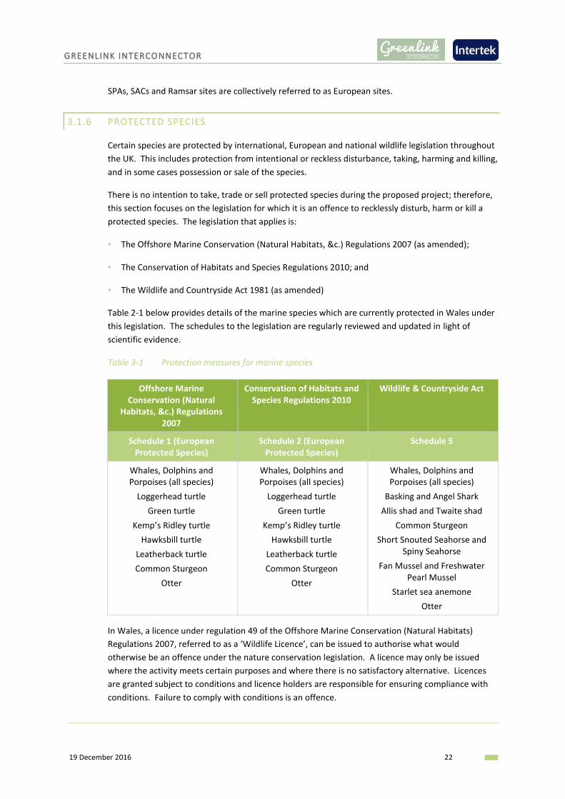
Table 2-1 below provides details of the marine species which are currently protected in Wales under
this legislation. The schedules to the legislation are regularly reviewed and updated in light of
scientific evidence.
Table 3-1 Protection measures for marine species
Offshore Marine Conservation (Natural
Habitats, &c.) Regulations 2007
Conservation of Habitats and Species Regulations 2010
Wildlife & Countryside Act
Schedule 1 (European Protected Species)
Schedule 2 (European Protected Species)
Schedule 5
Whales, Dolphins and Porpoises (all species)
Loggerhead turtle
Green turtle
Kemp’s Ridley turtle
Hawksbill turtle
Leatherback turtle
Common Sturgeon
Otter
Whales, Dolphins and Porpoises (all species)
Loggerhead turtle
Green turtle
Kemp’s Ridley turtle
Hawksbill turtle
Leatherback turtle
Common Sturgeon
Otter
Whales, Dolphins and Porpoises (all species)
Basking and Angel Shark
Allis shad and Twaite shad
Common Sturgeon
Short Snouted Seahorse and Spiny Seahorse
Fan Mussel and Freshwater Pearl Mussel
Starlet sea anemone
Otter
In Wales, a licence under regulation 49 of the Offshore Marine Conservation (Natural Habitats)
Regulations 2007, referred to as a ‘Wildlife Licence’, can be issued to authorise what would
otherwise be an offence under the nature conservation legislation. A licence may only be issued
where the activity meets certain purposes and where there is no satisfactory alternative. Licences
are granted subject to conditions and licence holders are responsible for ensuring compliance with
conditions. Failure to comply with conditions is an offence.

GREENLINK INTERCONNECTOR
19 December 2016 23
It is not anticipated that activities undertaken in the construction, operation and maintenance of
Greenlink will recklessly disturb, harm or kill any protected species. Where there is the potential for
accidental harm that could injure a protected species e.g. vessel collision, the significance of the
impact will be assessed.
It is not considered likely that any Wildlife licences will be required for this project.
3.1.7 MARINE ARCHAEOLOGY
As part of the UK marine licencing consultation, the statutory stakeholder Cadw (Welsh
Government’s historic environment service) requires that the following legislation is considered
during the assessment of impact:
▪ Protection of Wrecks Act 1973
▪ Ancient Monuments and Archaeological Areas Act 1979
▪ Protection of Military Remains Act 1986
On consideration of this legislation and prior to work being conducted, a project specific Written
Scheme of Investigation (WSI) for Archaeological Remains and a Protocol for Archaeological
Discovery (PAD) are required to minimise disturbance and destruction of archaeological features and
set out a methodology for investigation.
A draft WSI will be provided with the draft Marine Licence applications for review.
3.1.8 OTHER EUROPEAN DIRECTIVES
Water and sediment quality are monitored and regulated in the UK under a number of EC Directives.
The most relevant to the project are:
▪ Directive 2008/56/EC establishing a framework for community action in the field of marine
environmental policy (Marine Strategy Framework Directive, MSFD);
▪ Directive 2000/60/EC establishing a framework for Community action in the field of water policy
(Water Framework Directive, WFD);
▪ Directive 2006/7/EC concerning the management of bathing water quality (Bathing Waters
Directive, BWD); and
▪ Directive 2006/113/EC on the quality required of shellfish waters (Shellfish Waters Directive,
SFWD).
The WFD established a framework to protect and improve the ecological health of European waters,
including inland surface waters (rivers and lakes), transitional waters, coastal waters and
groundwater. Protection of coastal waters under the WFD extends from the mean low water mark
up to one nm from shore and requires that licensed projects or activities do not ‘cause deterioration
in a water body’. The MSFD considers water beyond 1nm.
The BWD and the SFWD are only applicable at designated bathing waters and shellfisheries,
respectively.

GREENLINK INTERCONNECTOR
19 December 2016 24
As part of the marine licence applications, Greenlink will consider the effects of the project in
accordance with the above Directives as appropriate.
3.1.9 CROWN ESTATE LICENCES
The Crown Estate own and manage the majority of the seabed out to the 12nm territorial limit.
Permission is needed for rights to lay, maintain and operate cables on areas of seabed for which they
are the landlord. The Crown Estate also request that they are informed of cables that transit the UK
continental shelf (within the 200nm limit), as other activities may be impacted. A Crown Estate
Licence will be required for the right to install and operate Greenlink.
Seabed Survey Licences are the formal permissions granted by The Crown Estate for temporary
activities that take up to a maximum term of six months and physically affects the foreshore and/or
seabed that we manage. A Seabed Survey Licence will be required for pre-construction marine
survey grab sampling.
3.1.10 CROSSING AND PROXIMITY AGREEMENTS
At the early stages of the project, The Crown Estate provided details of third party infrastructure
present which may be crossed or in close proximity to Greenlink within UK waters (see Section 6.3).
The crossing of third party infrastructure is made with prior agreement of the owners following a
negotiated formal Crossing Agreement (CA). The CA describes the rights and responsibilities of the
parties and also the detailed physical design of the crossing. The design addresses the need to
protect both the cables and the third-party infrastructure and other aspects such as crossing angle
and vertical separation. In some cases the crossing location, relative to sensitive structures, e.g.
subsea valves or cable repeaters, is specified. A proximity agreement similarly protects the third
party asset and is negotiated if cable routing is unable to avoid infrastructure completely. Greenlink
has the responsibility to ensure the third party asset integrity is not affected.
The exact physical design of the crossing will depend on both the negotiated CA and the resources of
the installation contractor and may vary from location to location.
3.1.11 PORT OF MILFORD HAVEN PERMITS
The marine survey (in particular geotechnical) and cable installation will require a Marine Works
Licence from the Harbour Authority. They will request opinion from NRW in relation to potential
impacts on protected sites and will need sufficient information with the application to undertake an
Appropriate Assessment.

GREENLINK INTERCONNECTOR
19 December 2016 25
4. PHYSICAL ENVIRONMENT
4.1 METOCEAN CONDITIONS
4.1.1 EXISTING BASELINE
4.1.1.1 WIND
The region has a temperate maritime climate whose wind regime is driven by high and low pressure
systems. Frontal depressions generally approach from the Atlantic moving east or northeast, while
areas of high pressure (anticyclones) tend to reduce wind speeds and, if they become stationary over
the region, can fend off the arrival of depressions.
The prevailing wind direction is generally south-westerly over much of the northeast Atlantic and
this is the case over the proposed marine cable route.
Generally, the strongest winds are reported during the autumn and winter, with winds of Force 6
and over being reported in December on around 35% of occasions off the west coast of Wales. This
frequency falls to about 9% by July (DTI 2005a).
4.1.1.2 WATER LEVELS AND CURRENTS
Water levels and currents in the region are driven by astronomical tides and occasional storm surges.
The tides are semi-diurnal (two high and two low waters each day) and their range varies through
the lunar cycle reaching a maximum (spring tide) every 2 weeks. The mean spring range is around
3m to 3.5m near the UK/Irish median line, increasing to 7m at the Freshwater West landfall. Spring
tides reach peak speeds of 1.0 to 1.5 m/s generally in a northwest-southeast direction past the
Pembrokeshire coast; they are nearly rectilinear, i.e. they have very little movement perpendicular
to their main direction of flow. Peaks during neap tides are 0.75 m/s (Barne et al 2005).
Storm surges occur when deep depressions move through the area and may temporarily increase
the water level by up to 1.3m in extreme cases. They are weaker than tides in this area, having
estimated speed of around 0.4m/s in an extreme (50-year return period) event.
There is thought to be a slow residual surface current drift of the order of 2km per day. Its direction
is said to be generally northward.
4.1.1.3 WAVES
The wave regime is a product of the winds described above. Exposure to largest waves is more
pronounced on coasts and submarine shoals facing the longest fetch from the south-west and in
environments where the wave energy has been least dissipated by the interaction of waves with
shoaling seabed. Wave motions follow a roughly circular trajectory, forward on a wave crest and
backward on the following trough. These motions can extend to great depth below the surface
(several tens of metres) so that they can mobilise seabed sediment, or exert force on seafloor cables
and other structures (DTI 2005a).

GREENLINK INTERCONNECTOR
19 December 2016 26
The average wave height for the proposed marine cable route ranges from 1.75m to 2m at the
UK/Irish median line increasing to between 2.5m to 4m at the Freshwater West landfall (Barne et al
2005).
4.1.1.4 TEMPERATURE AND SALINITY
The surface temperature of seawater varies with the seasons, being coldest in February/March at
between 6°C to 8.5°C, and warmest in August/September, when it varies between 14°C and 16°C.
The magnitude of this variation is greater in coastal waters. The surface water may be up to 5°C
warmer than the bottom layer. Water salinity is fairly constant throughout the year and at all depths
along the proposed marine cable route. A salinity of 35 is typical (DTI 2007a).
4.1.2 IDENTIFICATION OF KEY SENSITIVITIES AND POTENTIAL IMPACTS
4.1.2.1 KEY SENSITIVITIES
None envisaged.
4.1.2.2 POTENTIAL IMPACTS
Modifications of metocean regime: It is not anticipated that cable installation, operation or
maintenance will have any significant impacts on the metocean regime. Marine cables will be
buried, where possible, and any changes to the seabed profile associated with cable protection
material will be localised. At most, cable protection may cause very local changes to tidal or wave-
induced current flows but is unlikely to cause measureable or long-term changes to metocean
conditions. Any impacts would most likely be observed in the shallower coastal waters near the
landfall, but these environments tend to be fairly dynamic (for example, due to wave activity) and
the affected corridor will be relatively small.
Impacts on the wider metocean environment will be negligible, and certainly considerably lower
than the natural variability in metocean conditions. It is proposed that this impact is scoped out of
the EA at this stage.
Changes to seabed temperature: When cables are in operation, localised heating of the environment
may occur surrounding the cables (i.e. sediments including interstitial water, where cables are
buried, rock berms/concrete mattresses when cable protection employed). Seawater temperatures
within the Celtic Sea vary seasonally and therefore are likely to accommodate minor localised
variations in temperature associated with thermal losses.
Impacts on seabed temperature will be negligible and it is proposed that this impact is scoped out of
the EA at this stage.
4.1.3 ENVIRONMENTAL APPRAISAL APPROACH
No significant impacts on the metocean conditions of the project area are anticipated and therefore
it is considered that no further assessment is required within the EA. However, a detailed baseline
description will be included as the metocean conditions have a significant influence on other impacts
being assessed within the EA.

GREENLINK INTERCONNECTOR
19 December 2016 27
Metocean conditions will be characterised using publicly available data such as:
▪ UKHO Admiralty charts and pilots;
▪ OSPAR Region III Status Report - Celtic Seas. OSPAR Commission, London;
▪ Strategic Environmental Assessment (SEA) 8 (OESEA) Western English Channel and Celtic Sea and
Offshore Energy SEAs;
▪ Charting Progress 2;
▪ JNCC Coastal Directories, Barne et al Region 12 (1995); and
▪ NERC UK Digital Marine Atlas Project (1998).
4.2 GEOLOGY, GEOMORPHOLOGY AND SEDIMENTARY PROCESSES
4.2.1 EXISTING BASELINE
4.2.1.1 BATHYMETRY
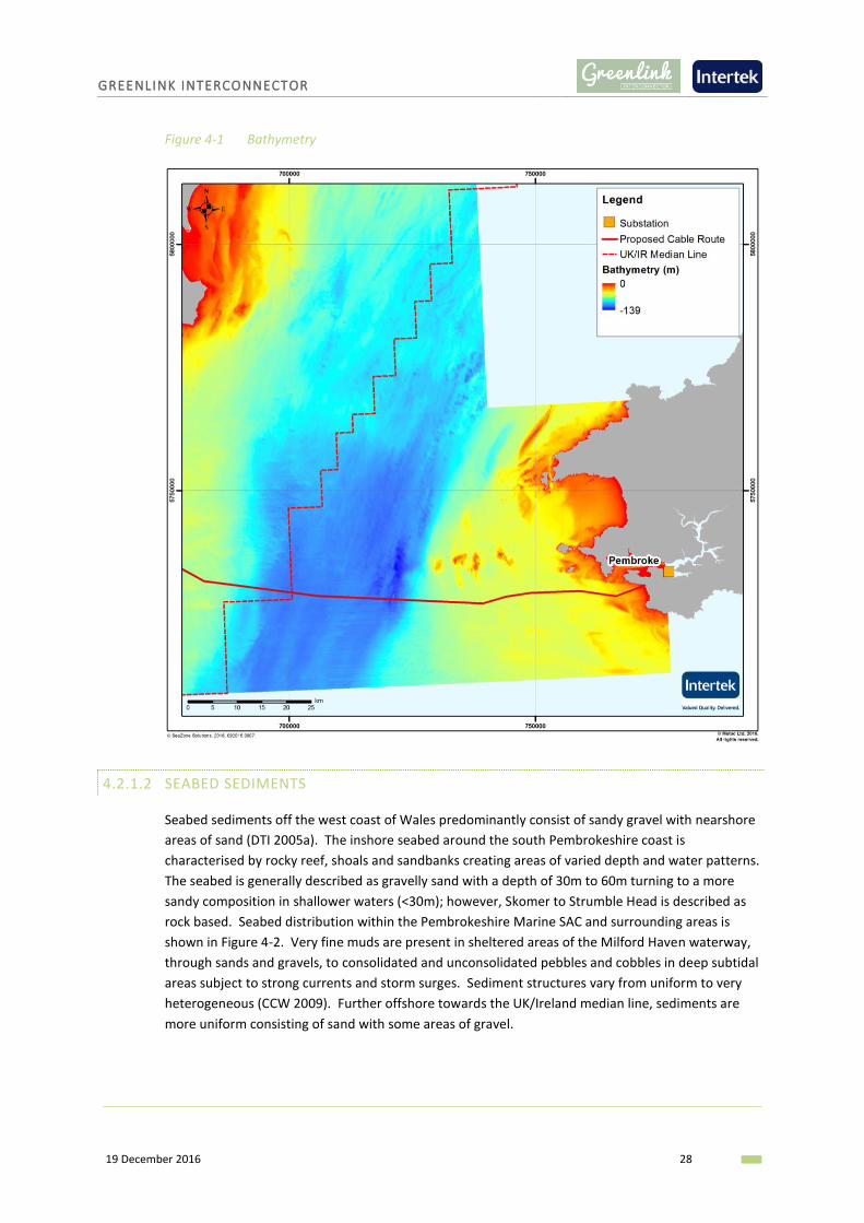
The dominant bathymetric feature off the west coast of Wales is a wide trough, having a maximum
depth in excess of 100m which runs the length of St Georges Channel between Wales and Ireland
(Figure 4-1). Along the proposed marine cable route, the water depths range from 91-120m at the
UK/Ireland median line to 0-30m close to the Pembrokeshire coast.
GREENLINK INTERCONNECTOR
19 December 2016 28
Figure 4-1 Bathymetry
4.2.1.2 SEABED SEDIMENTS
Seabed sediments off the west coast of Wales predominantly consist of sandy gravel with nearshore
areas of sand (DTI 2005a). The inshore seabed around the south Pembrokeshire coast is
characterised by rocky reef, shoals and sandbanks creating areas of varied depth and water patterns.
The seabed is generally described as gravelly sand with a depth of 30m to 60m turning to a more
sandy composition in shallower waters (<30m); however, Skomer to Strumble Head is described as
rock based. Seabed distribution within the Pembrokeshire Marine SAC and surrounding areas is
shown in Figure 4-2. Very fine muds are present in sheltered areas of the Milford Haven waterway,
through sands and gravels, to consolidated and unconsolidated pebbles and cobbles in deep subtidal
areas subject to strong currents and storm surges. Sediment structures vary from uniform to very
heterogeneous (CCW 2009). Further offshore towards the UK/Ireland median line, sediments are
more uniform consisting of sand with some areas of gravel.

GREENLINK INTERCONNECTOR
19 December 2016 29
Figure 4-2 Seabed sediments
4.2.1.3 GEOLOGY
The underlying geology is reported to consist of Palaeozoic rock (541 – 252.17 million years ago)
overlain by Permian (252.17 – 298.9 million years ago), Mesozoic (252.17 – 66 million years ago) and
Tertiary strata (66 – 2.58 million years ago), of which overlying Quaternary sediments locally exceed
300m in depth (Tappin et al. 1994).
Coastal
The Pembrokeshire Marine SAC area has a rich and complex geology. The southern part, which the
proposed marine cable route passes through, is dominated by old red sandstone and carboniferous
rocks, notably the limestone block of the Castlemartin coast, and the silurian volcanics of the
Marloes Peninsula, Skomer and offshore rocks and islands. There has been a spectacular degree of
rock faulting and folding. The coastal cliffs of highly faulted Cambrian (northern St Brides Bay
shoreline) and old red sandstone (southern St Brides Bay, West Dale, Freshwater West) shorelines
have extensive sublittoral extension. Softer more recent rocks form cliffs behind and underlying
sediment on the lower shores on eastern shorelines (CCW 2009).

GREENLINK INTERCONNECTOR
19 December 2016 30
Offshore
The central Celtic Sea comprises Upper Cretaceous (100.5 – 66 million years ago) and Paleogene
sedimentary rock (66 – 23.03 million years ago), with Devonian to Carboniferous rock extending
along the coast of southern Ireland (Tappin et al. 1994).
4.2.1.4 SEDIMENT TRANSPORT PATHWAYS
The hydrodynamic conditions present in the Irish Sea are heavily influenced by tidal stream strength.
Tidal streams increase in strength from north to south, from approximately 0.2m/s to 1.2m/s
respectively. The differing hydrodynamic conditions in this area are reflected in the spatial variation
in sediment particle size and bedform distribution. A sand parting zone is present across the Irish
Sea from Dublin Bay to the Lleyn Peninsula from which sands migrate north and south parallel to the
UK/Irish Coast. Soft glacial coastal sediments have little resistance to the hydrodynamic conditions
and therefore impacts from erosion are significant; this is lessened slightly by the supply of
sediments from the offshore banks (DTI 2005a). Detailed sediment processes in St George’s Channel
are poorly known but are dominated by tidal currents. Around the Pembrokeshire coast, strong tidal
currents are present which suspend high levels of seabed particles in the water column.
4.2.2 IDENTIFICATION OF KEY SENSITIVITIES AND POTENTIAL IMPACTS
4.2.2.1 KEY SENSITIVITIES
None envisaged.
4.2.2.2 POTENTIAL IMPACTS
Changes to seabed bathymetry and seabed features: The physical disturbance caused by cable
installation, e.g. excavation of sediment and underlying bedrock, has the potential to affect
sedimentary structures and bedforms, solid geology or geomorphologic features. In areas of seabed
where the marine cables are buried, any changes in seabed morphology will be localised and
temporary. Where burial cannot be achieved and cable protection measures are necessary it is
unlikely to significantly alter the physical condition of area.
A large area of mobile sandwaves is known to be present in Irish offshore waters and it is possible
that this may extend across in UK offshore waters. The proposed marine route has been designed to
avoid this area as it poses technical challenges, however, if the marine survey identifies the sand
waves are more extensive than originally thought small amounts of localised pre-sweeping may be
required. Pre-sweeping has the potential to have a significant effect on seabed features and this
potential impact will be considered in more detail in the EA once the marine survey is complete.
Changes to sediment regime and coastal processes: This refers to the wide-scale transport of
suspended sediment or bedload, with knock-on effects on (for example) local sediment budgets and
beach stability. Changes could in theory be caused by a change in the current flow regime
associated with tidal or wave action, and/or a change in the seabed morphology or seabed surface
sediment composition. Changes to seabed morphology and sediment composition may result from
the cable installation process or, potentially, scour around cable protection measures. It is
considered likely that, at most, any such changes will affect only a small area in the short-term.

GREENLINK INTERCONNECTOR
19 December 2016 31
Following installation, the seabed sedimentary environment will quickly return to its pre-installation
state. Any scour around cable protection will reach a dynamic equilibrium and will not impact the
wider environment in the longer term. It is therefore considered unlikely that the project will cause
any significant impacts on sediment transport paths and associated processes. It is therefore
proposed that this impact is scoped out of the EA at this stage.
4.2.3 ENVIRONMENTAL APPRAISAL APPROACH
Table 4-1 Geology, geomorphology and sedimentary processes EA approach
Data Requirement Method Data Sources
Desk based review A desk based review of publicly available data will be used to describe the physical environment.
Strategic Environmental Assessment 8 (OESEA);
BGS UK Offshore Regional Reports: The geology of the Irish Sea 1995;
BGS Seabed Sediments Digital data;
JNCC Coastal Directories, Barne et al Region 12 (1995);
Countryside Council for Wales (CCW). Pembrokeshire Marine European Site. Advice
Marine survey Geophysical and geotechnical surveys of the cable route will provide an understanding of the baseline bathymetry, seabed sediments, shallow geology and seabed features along the proposed marine cable route.
Seabed survey of the marine cable corridor
Consultation Consultation with the regulatory authorities and their Statutory Nature Conservation Agencies (SNCA).
JNCC, NRW, MMO, BGS
4.3 WATER AND SEABED QUALITY
4.3.1 EXISTING BASELINE
Water and sediment quality at any particular location on the UK continental shelf is the result of a
combination of source, transport and removal mechanisms for the individual chemical species under
consideration. There are many routes by which substances with the potential to affect water quality
enter the Celtic Sea, both through natural processes and as a result of anthropogenic activity, with a
general downward trend in anthropogenic inputs over the past few decades (UKMMAS 2010).
4.3.1.1 WATER QUALITY
The EU Marine Strategy Framework Directive adopted in 2008 requires that the UK takes “the
necessary measures to achieve or maintain Good Environmental Status in the marine environment
by the year 2020 at the latest” (UKMMAS 2010). The report on the current state of the UK seas
(UKMMAS 2010) concludes that good progress has been made towards this end with significant
contamination restricted to industrial estuaries and coastal areas.
The requirement for monitoring of UK rivers and near-shore waters has increased as a result of the
implementation of the EU Water Framework Directive (WFD), with more stringent criteria for water
quality in rivers applied. River Basin Management Plans (RBMP) are being developed as a
GREENLINK INTERCONNECTOR
19 December 2016 32
requirement of the WFD and report on the ‘ecological status’ of surface and ground water in coastal
waters (out to 1nm from the baseline) and ‘chemical status’ of surface and ground waters in
territorial waters (out to 12nm from the baseline). The proposed marine cable route is located within
the Western Wales River Basin District.
Water quality, defined in terms of bacterial concentration, is monitored within Bathing Waters
designated under the revised Bathing Water Directive (2007/7/EC). These are classified as Excellent,
Good, Sufficient and Poor. The beaches within close proximity to the Freshwater West landfall have
been assessed as having excellent water quality for the last four years (Pembrokeshire County
Council 2016). Water quality is also monitored for shellfish waters designated under the Shellfish
Waters Directive 79/923/EEC and requires specification of protected areas for protection of
economically significant species. Currently the nearest shellfish water to the Freshwater West
landfall is the Milford Haven Cleddau approximately 13km to the north-east.
4.3.1.2 SEDIMENT QUALITY
Sediment contamination may result from natural and anthropogenic inputs that are harmful to
biota. Dissolved contaminants in the Celtic Sea and off the Pembrokeshire coast are low or below
the level of detection for current analytical tools. Coastal waters contain the highest concentrations
of contaminants as they are within close proximity to run off from industry. However, contamination
along the south Pembrokeshire coast does not exceed environmental quality standards (EQSs) for
metals and maximum allowable concentrations (MACs) for alkylphenolic chemicals.
Hydrocarbons such as polycyclic aromatic hydrocarbons (PAH) can occur naturally in the marine
environment as well as from anthropogenic inputs; and concentrations can vary widely. However,
concentrations of contaminates into the Celtic Sea from coastal industries in offshore samples and
the south coast of Pembrokeshire do not exceed their MACs.
Persistent organic compounds include polychlorinated biphenyls (PCBs) and Tributyltin (TBT). PCBs
concentrations are decreasing across the Celtic and Irish Sea but are highest in industrialised regions
such as harbours. TBT is a widespread contaminant of coastal waters and sediments due to its use
an antifoulant on marine structures and shipping. OSPAR (2010) reports suggest that levels of TBT
are acceptable across the Celtic Sea but there are still areas of high concentrations such as harbours
and shipping lanes.
4.3.2 IDENTIFICATION OF KEY SENSITIVITIES AND POTENTIAL IMPACTS
4.3.2.1 KEY SENSITIVITIES
▪ Freshwater West and surrounding areas bathing water
4.3.2.2 POTENTIAL IMPACTS
Disturbance of natural seabed sediments: Sediments will be disturbed during cable installation and
to a lesser extent during cable maintenance and repairs. The coarser fraction of the sediment
disturbed is likely to be initially re-deposited on the seabed close to the works, but will remain
mobile. Any fine material released in a high energy area will disperse widely with eventual
GREENLINK INTERCONNECTOR
19 December 2016 33
deposition over a large area i.e. in a sediment plume. Where seabed operations impact low energy
areas, fine sediments may be disturbed and large quantities of fine material could be released.
Placement of cable protection material on the seabed also has the potential to change the nature of
the seabed through the introduction of material of different geological origin.
Construction activity in the intertidal area has the potential to compact natural sediments, as
vehicles move up and down the beach. This compaction can have an indirect impact on marine
ecology.
The significance of the disturbance will be assessed in more detail in the EA.
Disturbance of contaminated sediments: The potential adverse effects of disturbing historically
contaminated sediments during cable installation depend on the nature (e.g. domestic or industrial
waste, munitions) of the potential contamination source and local receptors. The proposed marine
cable route has been routed to avoid existing and historic disposal sites where possible. However, as
discussed in Section 6.4 below, it passes within close proximity of a historic site within Welsh
territorial waters. There is therefore the potential for contaminated sediments to be disturbed and
distributed throughout the area where the sediment plume is present.
Change in water / sediment quality: There are two pathways through which the proposed project
could potentially affect water and/or sediment quality:
▪ By increasing suspended sediment concentrations; and
▪ Through intentional or unplanned discharges e.g. sewage, ballast water or unplanned releases of
hydrocarbons or chemicals including HDD drilling fluids.
An increase in suspended sediment loads is often of particular concern if shellfish waters or
aquaculture sites are located close by. As described above the coarser fractions of sediment will
settle out of suspension within close proximity of the cable trench, whilst finer particles will disperse
widely over a large area. However, there are no aquaculture sites nor shellfish waters within close
proximity of the proposed marine cable route. The other concern is that a change in water quality
would have an indirect effect on benthic communities, fish species and certain diving bird species.
The potential significance of these impacts will be considered in the respective topic chapters.
Project vessels will comply with the International Marine Organisation (IMO) International
Convention for the Prevention of Pollution from Ships (MARPOL) standards. No discharges of waste
or sewage are permitted within 12nm of the coast, therefore no impacts to bathing waters are
anticipated. Impacts of discharges offshore will be temporary and localised and are unlikely to have
a significant effect on water quality.
Ballast water is pumped in to a vessel to maintain safe operating conditions throughout a voyage.
The multitude of marine species carried in ships’ ballast water may pose ecological problems as
transferred species may survive a voyage and be discharged at a destination. Here they may
establish a reproductive population in the host environment, becoming invasive and out-competing
native species. The potential for a significant impact will depend on the vessels used and their
provenance, although discharges are managed under International Convention for the Control and
Management of Ships’ Ballast Water and Sediments.

GREENLINK INTERCONNECTOR
19 December 2016 34
The presence of project vessels will marginally increase the risk of a pollution incident. The running
aground of a vessel or a collision could lead to a fuel spill and cleaning fluids, oils and hydraulic fluids
used onboard cable lay vessels and during ROV operation could be spilled overboard or accidentally
discharged. The significance of the impact will depend on the nature of the spill and the sensitivity
of the receiving environment within the footprint of the spill. The potential significance of an impact
will be considered in more detail by the EA.
4.3.3 ENVIRONMENTAL APPRAISAL APPROACH
Table 4-2 Water and sediment quality EA approach
Data Requirement Method Data Sources
Desk based review A desk based review of publicly available data will be used to describe the water quality and sediment contamination in the project area.
Any risks to water quality and sediment contamination as a result of the project will be identified and assessed within the EA.
SEA 8 (OESEA)
Marine survey - -
Consultation Consultation with NRW will identify any requirements for analysis of existing sediment contamination.
NRW

GREENLINK INTERCONNECTOR
19 December 2016 35
5. BIOLOGICAL ENVIRONMENT
5.1 INTERTIDAL AND BENTHIC COMMUNITIES
5.1.1 EXISTING BASELINE
Intertidal and benthic ecology comprises the habitats and species (flora and fauna) present in, on or
closely associated with the seabed. A high level assessment of the key sensitive habitats and species
along the proposed marine cable route has been made by reviewing the following data sources:
▪ European Nature Information System (EUNIS) Habitats 2012 – Compiled by JNCC on behalf of
MESH using existing studies and survey data
▪ Marine European Seabed Habitat (MESH) Predicted EUNIS Habitats 2008 GIS Data – Modelled
predicted habitats based on physical hydrographic information within different habitats areas
and water depths.
The MESH project has collated studies and survey data to map EUNIS habitats present on the seabed
of north-west Europe. Within the study area this data is predictive rather than definitive however it
does provide some indication to the types of benthic habitats that may be found. These EUNIS
habitats are presented in Table 5-1 with specific benthic habitats shown in Figure 5-1.
The waters around Freshwater West are characterised by its sedimentary shore which supports rich
invertebrate fauna including various species of polychaetes, molluscs and algae (Davies 1998).
In contrast to this, the varied seabed sediments around Skokholm and Skomer gives rise to a range
of benthic fauna particularly around Skomer Island which is recognised as a site of significant
biological and conservation importance and a designated MCZ. This is partly due to the strong tides
and water currents which bring new supplies of food and nutrients and well as its varied seabed
habitats. Invertebrates living in or on the seabed include the broad sea fan Eunicella verrucosa and
the scarlet-and-gold star coral Balanophyllia regia which are at the limit of their geographical range
and also species which are more localised such as the colonial anemone Parazoanthus axinellae. The
areas of coarse, current exposed shelly gravel in this region support a low variety of physically
resilient species (CCW 2005).
Within the wider Pembrokeshire Marine SAC, the area supports habitat features of varying
individuals scale, distribution, significance, quality and sensitivity. High biological diversity is present
and as stated above, this area is positioned at a biogeographically boundary between northern and
southern species. The mixed sediments support long-lived macrofauna buried within and living on
the sediment surface and rare infauna including molluscs (Ensis and Arctica); anthozoans
(Mesacmea, Peachia, Aureliania); tube living polychaetes and echinoderms. Sediment epifauna
includes a relatively isolated population of great scallop (Pecten maximus) and a wide variety of
species characteristic of reefs living on and in stony material, molluscan shell debris and in
association with species consolidating mobile substrates, e.g. Ross coral (Pentapora folicea) (CCW
2005).
Further offshore at the UK/Ireland median line, richly abundant and diverse polychaete dominant
communities are present within the soft sedimentary seabed although patches of muddy, sandy
gravel are still present (DTI 2005b).

GREENLINK INTERCONNECTOR
19 December 2016 36
Table 5-1 EUNIS habitats present along the proposed marine cable route
EUNIS Code EUNIS Name JNCC Biotope Annex I Habitat Type UK BAP Habitat / Priority Marine Feature
Typical Fauna
A4.2 Atlantic and Mediterranean moderate energy circalittoral rock
CR.MCR Reefs Tidal rapids This habitat type contains a broad range of biological subtypes, from echinoderms and crustose communties (A4.21) to Sabellaria reefs (A4.22) and circalittoral mussel beds (A4.24).
A5.13 Infralittoral coarse sediment
SS.SCS.ICS Sandbanks which are slightly covered by seawater all the time
Subtidal sands and gravels Characterised by robust fauna including infaunal polychaetes such as Chaetozone setosa and Lanice conchilega, Cumacean crustacea such as Iphinoe trispinosa and Diastylis bradyi, and venerid bivalves.
A5.14 Circalittoral coarse sediment
SS.SCS.CCS Sandbanks which are slightly covered by seawater all the time
Subtidal sands and gravels Characterised by robust infaunal polychaetes, mobile crustacea and bivalves. Certain species of sea cucumber (e.g. Neopentadactyla) may also be prevalent in these areas along with the lancelet Branchiostoma lanceolatum.
A5.15 Deep circalittoral coarse sediment
SS.SCS.OCS - Subtidal sands and gravels Characterised by robust infaunal polychaete and bivalve species including Modiolus modiolus.
A5.25 Circalittoral fine sand SS.SSa.CFiSa Sandbanks which are slightly covered by seawater all the time -
Subtidal sands The habitat may also extend offshore and is characterised by a wide range of echinoderms (in some areas including the pea urchin (Echinocyamus pusillus), polychaetes and bivalves. This habitat supports a more diverse community.
A5.26 Circalittoral muddy sand
SS.SSa.CMuSa Sandbanks which are slightly covered by seawater all the time
Subtidal sands Characterised by a wide variety of polychaetes, bivalves such as Abra alba and Nucula nitidosa, and echinoderms such as Amphiura spp and Ophiura spp., and Astropecten irregularis.

.
Cre ate d ByRe vie w e d By
Jennifer ArthurEmma Langley
Monday, December 19, 2016 09:15:37WGS_1984_UTM_Zone_30N
D_WGS_1984Seazone, JNCC, DECCJ:\P1975\Mxd\Scoping Report\Report Figures\Fig5_1_Benthic_Habitats_UK.mxd
WGS_1984
DateProje ction
DatumData Source
File Re fe re nce
Sphe roid
NOTE: Not to be used for Navigation
© SeaZone Solutions, 2013, 092015.0007.
Approve d By Anna Farley
300000
300000
325000
325000
350000
350000
5700000
5700000
5725000
5725000
5750000
5750000
Le ge ndProposed Cable Route
Median Line12nm limit
0 3 6 9 12 15km
.
© Me toc Ltd, 2016.All rights r e s e r ve d.
Figure 5-1 Be nthic habitats
EUNIS Clas s ificationAlgal turfBrittlestarsCircalittoral muddy sand (AbrNucCor)Exposed littoral rock with Mytilus edulis and barnacles (BPat.Fvesl; FvesB; Fser.R; Ala.Ldig)Faunal & Algal CrustsFaunal TurfGravelGravel & cobblesInfralittoral gravel/ sand with maerl beds (Phy)Infralittoral mixed sediment (FaMx; VsenMtru; LsacX)Infralittoral muddy sand with Abra alba and Nucula nitida (FaMS)Infralittoral rock with Laminaria digitata and Laminaria hyperborea (Lhyp.Ft; Lhyp.Pk)Infralittoral sand (Mob; ScupHyd; Lcon)Infralittoral sand and gravel (FaG; Sell)Kelp
Littoral bedrock and mixed substrata with fucoids (Fser.Fser.Bo; FvesX; FserX; Fves; Fspi; Pel)Littoral mixed sediment (LMX)Littoral mixed substrata with fucoids (FvesX; AscX; FserX; FserX.T)Littoral muddy sand (MacAre)Littoral rock with dense fucoids (BPat; Pel; Fspi; Fves; Asc.Asc; Fserr; Fserr.T)Littoral sand and gravel (Lan)Lower shore or infralittoral sediment with Zostera marina beds (Zmar)Moderately exposed infralittoral rock (MIR)Moderately exposed littoral rock (MLR)
MudMuddy sandSaltmarshSaltmarsh (Sm) and littoral soft mudSand
Moderately exposed littoral rock with barnacles, fucoids and red algal turfs
Gre e nlink Inte rconne ctorEnvironme ntal Scoping Re port –
UK Marine Route

GREENLINK INTERCONNECTOR
19 December 2016 38
5.1.2 IDENTIFICATION OF KEY SENSITIVITIES AND POTENTIAL IMPACTS
5.1.2.1 KEY SENSITIVITIES
▪ Designated habitats and species of protected sites.
▪ EC Habitats Directive Annex I habitats (designated or potential) e.g. reefs (stony or biogenic),
sandbanks which are slightly covered by seawater all the time.
▪ Estuaries
▪ Large shallow inlets and bays;
5.1.2.2 POTENTIAL IMPACTS
Temporary habitat loss – intertidal species: If for any reason HDD is not a feasible installation
technique at the landfall, open cut–trenching may be considered across the intertidal zone.
Intertidal species in the vicinity of the cable trench may be displaced or suffer direct mortality during
trenching operations, and will be temporarily unavailable as prey items for bird species. The
temporary habitat loss as a result of cable trenching would be minimal and restricted to a narrow
strip (approximately 10m wide). Construction activity (e.g. the movement of vehicles) also has the
potential to compact natural sediments and indirectly impact intertidal species. The area affected is
likely to represent only a small percentage of the available habitat. Following installation, the beach
profile would be restored to pre-impact conditions. More detailed assessment will be provided in
the EA.
Temporary habitat loss – subtidal species: Benthic communities in the zone of influence of the
marine cables will be impacted through substratum loss and direct displacement during cable laying
and maintenance operations. The significance of the impact varies according to the technique of
cable burial employed (e.g. jet or plough trenching) and the sensitivity of the habitat. It is likely that
in most cases any impacts to species and habitats will be localised and short term and once installed
the substratum will be reinstated over the cable.
The EA will provide more detailed assessment of the significance of this impact.
Smothering of species: Species will be smothered by two activities: the suspension and subsequent
deposition of sediments as a result of ploughing and trenching operations; and the placement of
cable protection material (if required) on the seabed. When suspended sediments resettle back on
to the seabed, sessile organisms can be smothered. Any significant impacts from smothering are
likely to be restricted to a very narrow extent beyond the cable trench (depending on current flow),
where the maximum thickness of sediment will be deposited. The significance of impact will depend
on sensitivity and recoverability of any species present within this impact footprint and will be
assessed in detail in the EA.
Cable protection (if necessary) through the placement of rock and or concrete mattresses on the
seabed will result in a direct, permanent but localised, change of habitat and potentially species. The
significance of the impact will vary according to the sensitivity of the habitat affected and will be
assessed in detail in the EA.

GREENLINK INTERCONNECTOR
19 December 2016 39
Disturbance of contaminated sediments: Re-suspension of contaminants is possible during cable
installation, should contaminated sediments be disturbed. This may have potential effects on
nearby species which are exposed to remobilised contaminants. The proposed marine cable route
avoids known areas of contamination and therefore the impact is unlikely to be significant.
However, it will be considered in the EA.
Introduction of new substrate: Where cable burial is not possible, rock protection or concrete
mattressing will be used to protect the exposed cable. This will be used in areas of hard substrate,
stony reef or bedrock and therefore will not represent a significant change to the existing baseline.
The impact is unlikely to be significant but will be considered in the EA.
Emission of EMF: The impact of electric and magnetic fields generated during cable operation on
benthic species is largely unknown. As benthic communities are typified by sessile or low-mobility
species, which are unlikely to navigate using magnetic fields and anomalies, these species, are less
likely to be impacted than more mobile species such as teleost fish, elasmobranchs and cetaceans.
The effects of EMF on intertidal and benthic communities will be assessed within the EIA.
Toxic effects from the unplanned release of hydrocarbons or chemicals: Depending on the location
and size of a hydrocarbon spill there is the potential that intertidal benthic communities could be
affected. Therefore, consideration will be given to the potential impact in the EA.
5.1.3 ENVIRONMENTAL APPRAISAL APPROACH
Table 5-2 Intertidal and benthic communities EA approach
Data Requirement Method Data Sources
Desk based review Desk based information on the benthic ecology of the project area and designated sites and species will be used to support the review of the specialist benthic survey data.
EMODnet (EUSeaMap) Predicted EUNIS Habitats data digital data 2012;
OSPAR habitats digital data 2014;
Davies, J. (1998). Bristol Channel and approaches;
DTI Strategic Environmental Assessment 8 (OESEA) Synthesis of Information on Benthos 2007;
DTI Strategic Environmental Assessment 6 Synthesis of Information on Benthos 2005.
Marine survey Survey data will be reviewed to establish the main habitats/biotopes occurring along the length of the marine cable route, and identify any areas of particular sensitivity which may be susceptible to impacts during construction, maintenance and operation activities.
Benthic survey data.
Consultation Request any information on known areas of conservation interest for benthic ecology such as Annex I Habitat.
Consult on necessity of intertidal survey if confirmed approach is HDD.
NRW, JNCC

GREENLINK INTERCONNECTOR
19 December 2016 40
5.2 FISH AND SHELLFISH
5.2.1 EXISTING BASELINE
The Strategic Environmental Assessment (SEA) 6 provides information on fish assemblages in the
Irish and Celtic Sea. The variable seabed conditions across the south-western coasts of England and
Wales supports a wide variety of fish species with distinct assemblages associated with particular
seabed conditions. Sandy inshore areas support large number of juvenile flatfish and sandeels, with
seasonal populations of sprat and herring. Rockier strata are characterised by small species such as
wrasse, gobies and blennies as well as juvenile Pollock (Pollachius). A number of demersal fish
spawn and have nursery grounds in the area whilst pelagic fish such as mackerel and herring range
widely within the region, migrating between summer feeding grounds and overwintering grounds
(Cefas 2005).
The Centre for Environment, Fisheries and Aquaculture Science (Cefas) provides information on
spawning ground for fish stock in the UK waters in the form of fisheries sensitivity maps (Coull et al.
1998 and Ellis et al. 2012). This data, presented in Figure 5-3, provides an indication of the species
that spawn and nurse within or close to the proposed marine cable route. These species include:
tope (Galeorhinus galeus); thornback ray (Raja clavata); herring (Clupea harengus); Atlantic cod
(Gadus morhua); whiting (Merlangius merlangus); blue whiting (Micromesistius poutassou); ling
(Molva molva); hake (Merluccius merluccius); anglerfish (Lophius piscatorius); sandeels
(Ammodytidae); horse mackerel (Trachurus trachurus); mackerel (Scomber scombrus); plaice
(Pleuronectes platessa); sole (Solea solea); lemon sole (Microstomus kitt); and sprat (Sprattus
sprattus).
With the exception of hake all species have a low to medium probability of 0 group fish (i.e. fish
within their first year of life) within the vicinity of the work site (The Scottish Government 2014).
The probability of 0 group hake increases to medium to high towards the UK/Irish median line. In
addition to fish noted to spawn and nurse in the area, horse mackerel (Trachurus trachurus) has
been identified as having a probability of 0 group varying between low to medium and medium to
high along the marine cable corridor. The likelihood of presence has been defined with reference to
the Random Forest probability of presence scale, low probability is defined as 0 ranging to high
probability at around 0.99 (maximum score is dependent on species type and ranges from 0.525 for
herring to 0.99 for haddock).
Important fish species
On the International Union for Conservation of Nature (IUCN) (the World Conservation Union) Red
List of Threatened Species; Atlantic cod and spurdog (Squalus acanthias) are listed as vulnerable and
sandeel (species Ammodytes tobianus) and sole are listed as deficient. In addition, sandeel, herring,
cod, whiting, European hake, blue whiting, spurdog, ling, plaice, mackerel and sole have been listed
on the UK Biodiversity Action Plan (UK BAP) as priority fish species (JNCC 2016a).
Commercially, the Atlantic herring (Clupea harengus) fishery within Milford Haven has considerable
local and commercial importance with its season running between December and February.
Spawning of herring usually takes place in late summer at depths of between 15-40m with herring
depositing their sticky eggs on coarse sand and gravel. The dependency of herring on these specific
substrates makes the species potentially susceptible to disturbance.

GREENLINK INTERCONNECTOR
19 December 2016 41
Sandeels are also susceptible to disturbance as they lay their eggs on the sediment and live within
close contact with the sediments. This species is important for the breeding success of some
seabirds which can be reduced dramatically when sandeel abundance decreases (Furness and Tasker
2000).
Elasmobranchs
Elasmobranchs (sharks, skates and rays) are among the most vulnerable marine fish due to their
slow growth rates, late maturity, low fecundity and productivity which limits their capacity to
recover from population declines. All sharks and rays are on the OSPAR list of threatened and
declining species.
The basking shark (Cetorhinus maximus) is the largest fish in the North Atlantic and the second
largest in the world. The shark is commonly seen at the surface in the summer months, particularly
around the western coasts of the UK, but it is less clear where they spend the winter. This species is
listed on the UK BAP as a priority marine species. The lesser and greater spotted dogfish
(Scyliorhinus canicula and Scyliorhinus stellaris) are also very abundant around western UK waters.
Diadromous species
Diadromous species are those which migrate between marine and freshwater as part of their
lifecycle. The sea lamprey (Petromyzon marinus) is listed on Annex II on the EC Habitats Directive
and is a qualifying feature for the Pembrokeshire Marine SAC. This species spawns within freshwater
but completes its lifecycle in the sea. The twaite shad (Alosa fallax) and Allis shad (Alosa alosa) are
both members of the herring family and also qualify as features for the designation of the
Pembrokeshire Marine SAC and are listed as Annex II species on the EC Habitats Directive (DTI
2009a). In addition, these two species are also listed as UK BAP priority fish species.

Created ByReviewed By
Jennifer ArthurEmma Langley
Monday, December 19, 2016 11:30:29WGS_1984_UTM_Zone_29N
D_WGS_1984DECC, GEBCO, CEFAS, UKHOJ:\P1975\Mxd\Scoping Report\Report Figures\Fish_UK.mxd
WGS_1984
DatePro jec tio n
DatumData So ur c e
File Referenc e
Sp hero id
Ap p r o ved By Anna Farley
0 10 20 30 40 50km © Meto c Ltd, 2014.
All rights reserved.
LegendMedian Line12nm limit
Sp awning areasCod spawning areaLemon Sole spawning areaNephrops spawning areaPlaice spawning areaSprat spawning areaHerring spawning areaSole spawning areaLing spawning areaMackerel spawning areaWhiting spawning areaHorse Mackerel spawning areaSandeel spawning areaHake spawning area
Nursery areasNephrops nursery areaCod nursery areaMackerel nursery areaLemon Sole nursery areaWhiting nursery areaAnglerfish nursery areaBlue whiting nursery areaEuropean hake nursery areaLing nursery areaSandeel nursery areaHerring Nursery AreaSole Nursery AreaThornback Ray Nursery AreaTope Shark Nursery AreaPlaice Nursery Area
Co d Mac kerel Lemo n So le Nep hro p s
Whiting Plaic e & Hake Sp rat Herring & Ho rse Mac kerel
Anglerfish Blue Whiting
Euro p eanHake
Sandeel
Ling
Figure 5-2 Fish sp awning and nursing areas
So le
Tho rnbac k Ray
To p e Shark
Proposed Cable Route
Greenlink Inter c o nnec to rEnvir o nmental Sc o p ing Rep o rt –
UK Marine Ro ute
GREENLINK INTERCONNECTOR
19 December 2016 43
5.2.2 IDENTIFICATION OF KEY SENSITIVITIES AND POTENTIAL IMPACTS
5.2.2.1 KEY SENSITIVITIES
▪ Demersal spawners: herring, sandeel and thornback ray;
▪ EC Habitats Directive Annex II species: sea lamprey, twaite shad and Allis shad;
▪ IUCN Red listed species e.g. Atlantic cod, spurdog and sandeel;
▪ OSPAR threatened and declining species: all sharks and rays; and
▪ UKBAP priority marine species e.g. sandeel, herring, cod, whiting, European hake, blue whiting,
ling, plaice, shad, mackerel, sole, spurdog and basking shark.
5.2.2.2 POTENTIAL IMPACTS
Habitat disturbance: Activities that physically disturb the seabed e.g. cable trenching, have the
potential to disturb species with demersal life stages (i.e. those that lay their eggs on specific seabed
types) such as herring, larval or juvenile ages, or species that live in contact with the seabed like
sandeel. Although disturbed, the composition of sediments are unlikely to significantly change and
the habitat should be suitable for demersal spawning again once activities have ceased. However, as
cable installation and maintenance activities are likely to take place during spring and summer due
to potentially better weather at this time, there is potential that a years’ recruitment could be
affected. The EA will consider the significance of this impact in further detail.
Substratum loss: The placement of cable protection in the form of rock or concrete mattresses (if
required) will result in the localised permanent habitat loss in the direct footprint of the cable
protection. The significance of this impact would depend on the extent of the cable protection
required, the reliance of a species of fish or shellfish upon the particular habitat and the extent of
habitat in the wider area. The presence of the rock protection (if used) could also represent a
change in habitat type, although this may represent a positive effect for some fish species, indirectly
increasing prey availability. As the quantity and position of cable protection is not currently known,
the EA will consider the significance of this impact in further detail.
Physical disturbance of mobile species: Could occur during cable installation, as a result of the
presence of the installation vessels and equipment (and associated noise) within the vicinity of
operations. This could result in the displacement of fish within the water column. The disturbance
from installation operations will be short term, localised and not considered to be significant given
existing background levels of noise and shipping in the St Georges Channel. This impact has been
scoped out of the EA.
Smothering of species: There are three pathways for species to be smothered as a result of project
activities: by displaced sediments during trenching; by the re-deposition of suspended sediment; and
by cable protection material being placed on the seabed. The impact from displaced sediment will
be very localised, only effecting species in the immediate vicinity of cable trenches. Suspended
sediment settlement levels are expected to be minimal with any material deposited likely to be
quickly re-suspended and distributed by natural hydrodynamic processes. The significance of the

GREENLINK INTERCONNECTOR
19 December 2016 44
impact of depositing cable protection will depend on the extent of the deposit and the nature of the
habitat. This impact will be considered in further detail in the EA.
Reduced feeding success of visual species: The suspension of sediments within the water column
from cable installation may cause small, localised and temporary turbidity before being re-deposited
on the seabed. A temporary reduction in the feeding capability of species relying on sight to locate
their prey may occur. Most species are likely to be tolerant to any changes in turbidity levels (likely
to be equivalent to those experienced during storm events) and the significance of the impact is
likely to be negligible. It is therefore proposed that the impact is scoped out of the EA at this stage.
Toxic effects from disturbance of contaminated sediments: Re-suspension of contaminants is
possible during cable installation, should contaminated sediments be disturbed. This may have
potential effects on nearby species which are exposed to remobilised contaminants. The proposed
marine cable route avoids known areas of contamination and therefore the impact is unlikely to be
significant. However, it will be considered in the EA.
Disturbance from electromagnetic fields (EMF): Electric and magnetic fields generated during cable
operation will be detectable by pelagic fish species such as salmon and certain electrosensitive fish
such as elasmobranchs. The effects of EMF on fish and shellfish species will be assessed in the EA.
Disturbance or injury from underwater noise: Noise will be generated from project vessels including
from dynamic positioning (DP) systems and during installation and maintenance from cable
trenching, ploughing and rock placement operations. The effects of noise on fish and shellfish will be
assessed in the EA.
Heating effects: Operation of the cables will produce heat as a consequence of the internal
resistance of the conductors. The degree of heating will depend on cable specification, however, it is
expected that cable heat will be rapidly dissipated and any heating of the seabed immediately
surrounding the cables will therefore be only marginally elevated above background levels.
Demersal fish species and shellfish in close contact with the seabed are not expected to be impacted.
It is therefore proposed that this impact is scoped out of the EA at this stage.
Collision of project vessels with basking sharks: Basking sharks have occasionally been sighted
within the Pembrokeshire Marine SAC and are considered particularly susceptible to collisions with
vessels due to their presence at the surface for feeding and apparent unawareness of vessels. The
EA will consider the potential impact of the project on this species.
Toxic effects of unplanned hydrocarbon or chemical release: Any unplanned release of surface
pollutants, such as diesel, mineral oils and chemicals from project vessels has the potential to have
toxic consequences for fish species. In fish life cycles the egg and juveniles stages are the most
vulnerable to toxicity in the water column, as adult fish are highly mobile and generally able to avoid
polluted areas. The EA will consider the potential impact of a hydrocarbon or chemical release on
fish and shellfish.

GREENLINK INTERCONNECTOR
19 December 2016 45
5.2.3 ENVIRONMENTAL APPRAISAL APPROACH
Table 5-3 Fish and shellfish EA approach
Data Requirement Method Data Sources
Desk based review The fish and shellfish section will identify the distribution of fish and shellfish in the project area (including spawning & nursery grounds), and their sensitivities to cable installation and operation impacts. Particular focus will be given to sandeels and herring which are recognised as sensitive to seabed disturbance. Species of conservation importance including any specific areas designated for their protection will be identified and assessed.
Information on fish spawning and nursery grounds from Cefas (Coull et al 1998 and Ellis et al 2012);
Strategic Environmental Assessment Provision of Fishing Activity Data;
UKBAP priority fish species.
Consultation Consultation with named consultees. MMO, Cefas, JNCC, NRW
5.3 BIRDS
5.3.1 EXISTING BASELINE
There are three SPAs whose boundaries are in close proximity to the proposed marine cable route:
Grassholm; Skokholm and Skomer; and Castlemartin Coast. Two of these areas regularly support at
least 20,000 seabirds and thus qualify as seabird assemblages of international importance under the
EC Birds Directive (79/409/EEC).
The Irish and Celtic Sea’s diverse habitats provide a suitable environment for a wide range of
seabirds and marine ducks. Around the Pembrokeshire coast species such as herring gulls (Larus
argentatus) and lesser black-backed gulls (Larus fuscus) are found throughout the year with
guillemots (Uria aalge), razorbills (Alca torda) and kittiwakes (Rissa tridactyla) found between July
and September. The latter part of this period is also important for fulmars (Fulmarus glacialis) and
manx shearwaters (Puffinus puffinus) and to a lesser extent puffins and terns (Stone et al. 1995).
Seabird distribution is influenced by various factors, the most important of which is the availability of
food (Stone et al. 1995). Fishing activity influences the distribution of species; most species of
seabirds feed on fish, either directly or as discards from fishing vessels. Most pelagic (and some
coastal) species (e.g. Manx shearwater, gannet, shag, terns, guillemot, razorbill, puffin) are active
fishers, feeding on sandeels, clupeid (herring, sprat) and gadoids (cod, whiting, haddock, saithe, blue
whiting). The distribution and abundance of all seabird species varies throughout the year. Due to
the highly mobile nature of seabirds and their food sources, any areas of high density are likely to
change between seasons and years (Forewind 2013).
The Pembrokeshire islands hold large numbers of manx shearwater, storm-petrel (Hydrobates
pelagicus), guillemot and razorbill, and include Grassholm with its 39,000 gannet (Morus bassanus),
making it the third largest colony on the planet. The coastal habitats of the Skokholm and Skomer
SPA support an important resident population of chough (Pyrrhocorax pyrrhocorax) as well as
breeding seabirds such as petrels, gulls and auks. The Castlemartin Coast is also an important area
for breeding chough with its extensive cliffs and diverse mix of habitats (JNCC 2016b). Table 5-8
provides further information regarding the SPAs within close proximity to the proposed marine cable
route.

GREENLINK INTERCONNECTOR
19 December 2016 46
5.3.2 IDENTIFICATION OF KEY SENSITIVITIES AND POTENTIAL IMPACTS
5.3.2.1 KEY SENSITIVITIES
▪ Species listed as designated features of SPAs within close proximity to the proposed marine cable
corridor e.g. chough, gannet, manx shearwater, storm-petrel, guillemot, razorbill, puffin, lesser-
black backed gull.
5.3.2.2 POTENTIAL IMPACTS
Physical disturbance: During cable installation, repair and maintenance activities, the presence of
project vessels/equipment could result in a temporary disturbance to birds in the immediate vicinity
of the works. Noise is the primary cause of disturbance although the physical presence of
vessels/equipment can also cause a disturbance effect due to physical and visual intrusion.
Disturbance may result in displacement of birds from an area of use (for feeding, breeding, resting,
passage etc.). Given the localised and temporary nature of disturbance, this impact is unlikely to be
significant for disturbance of feeding and foraging birds as they are likely to be able to find
alternative feeding grounds. This impact would be of most concern where disturbance could have
implications for breeding success for example disturbance of nesting birds during the breeding
season. Given the proximity of a number of SPAs, this will be assessed in further detail in the EA.
Temporary loss of food resources and habitat: An option to install the marine cables across the
intertidal zone using open-cut trenching is being considered. A narrow strip of intertidal zone will be
temporarily disturbed with the direct loss of intertidal species within the installation footprint. This
temporary depletion of invertebrate food resource will be restricted and any displaced birds are
likely to find alternative feeding sites. This will be assessed in further detail in the EA.
Toxic effects from unplanned hydrocarbon or chemical release: The presence of installation vessels
may increase the risk of a pollution incident. The significance of the impact will depend on the
nature of the spill (volume and fluid characteristics) and the sensitivity of the receiving environment
within the footprint of the spill. Marine birds are highly sensitive to hydrocarbon or chemical spills,
particularly diving and pelagic species. Control measures and oil pollution emergency plans will be in
pace and adhered to under MARPOL requirements for all project vessels. The significance of this
impact will be assessed in detail in the EA.

GREENLINK INTERCONNECTOR
19 December 2016 47
5.3.3 ENVIRONMENTAL APPRAISAL APPROACH
Table 5-4 Birds EA approach
Data Requirement Method Data Sources
Desk based review A desk based review of publicly available information will be used to characterise the sensitivity of coastal and marine birds in and around the project area.
SPA site synopsis
JNCC and NRW area data.
Consultation Request information from the named consultees which will inform the assessment of sensitivity of birds in the project area, particularly any bird surveys.
JNCC, NRW, MMO, Royal Society for the Protection of Birds (RSPB), British Trust for Ornithology (BTO).
5.4 MARINE MAMMALS AND REPTILES
5.4.1 EXISTING BASELINE
Marine mammals present in the study area include cetaceans (whales, dolphins and porpoises),
pinnipeds (seals) and potentially otter. Chelonians (marine turtles) are the only type of reptile that
may potentially be encountered (Hammond et al. 2008).
Most cetaceans are wide-ranging and individuals encountered within the UKCS form part of a much
larger biological population whose range extends beyond UK waters. As a result management units
(MUs) have been have been outlined for seven of the common regularly occurring species following
advice from the Sea Mammals Research Unit (DECC 2016) and the International Council for the
Exploration of the Seas (ICES). Theses provide an indication of the spatial scales at which impacts of
anthropogenic activities should be taken into consideration. Guidance on the application of the MUs
is currently pending. Species, for which MUs have been defined and the relevant MUs are shown in
Table 5-5.
All cetaceans and marine turtles are European Protected Species (EPS) protected under Annex IV of
EC Directive 92/43/EEC (the Habitats Directive), which lists species of Community Interest in need of
strict protection. It is an offence to deliberately capture, kill, injure or disturb animals classed as EPS.
Harbour porpoise (Phocoena phocoena), bottlenose dolphin (Tursiops truncates), grey seal
(Halichoerus grypus), common/harbour seal (Phoca vitulina) and otter (Lutra lutra) are listed under
Annex II of the Habitats Directive, which lists species whose conservation requires designation of
SACs.
5.4.1.1 CETACEANS
More than 28 cetacean species have been recorded in UK waters of which 11 occur regularly. Within
the Irish and Celtic Sea, approximately 15 species have been recorded and therefore may be
encountered along the marine cable route, at least on a seasonal basis.
Table 5-5 lists species which may be present in the study area and provides an appraisal of the
frequency of sightings.

GREENLINK INTERCONNECTOR
19 December 2016 48
Table 5-5 Cetacean species recorded within proximity of the proposed marine cable route
Species Frequency of sightings Applicable MU
Toothed whales (odontocetes)
Harbour porpoise (Phocoena phocoena)
Common from June through the autumn/winter. Peak period in August
Celtic and Irish Seas
Bottlenose dolphin (Tursiops truncatus)
Common year round but most frequent in summer.
The Channel, Celtic Sea & SW England
Short beaked common dolphin (Delphinus delphis)
Common off the western coasts of the UK, notable the Celtic Sea and Western approaches to the Channel.
Peak period is spring and summer with a winter peak on the south coast associated with prey items.
Celtic & Greater North Seas
Striped dolphin (Stenella coeruleoalba)
Occasional sightings, most frequent in summer and early autumn months.
N/A
Risso’s dolphin (Grampus griseus)
Peak period in April to September. Celtic & Greater North Seas
Atlantic white-sided dolphin (Lagenorhynchus acutus)
Summer months.
White-beaked dolphin (Lagenorhynchus albirostris)
More regular in late summer – autumn.
Long-finned pilot whale (Globicephala melas)
Most frequent between April and September.
N/A
Killer whale (Orcinus orca)
Occasional sightings off the south coast of Ireland and northern and Western Scotland, but rare in the Irish Sea and south-western UK waters.
N/A
Baleen whales (mysticetes)
Minke whale (Balaenoptera acutorostrata)
Peak period May to September. Celtic & Greater North Seas
Humpback whale (Megaptera novaengliae)
Occasional sightings. N/A
Fin whale (Balaenoptera physalus)
Occasional sightings between June and Decembers
N/A
Sources: Marine Institute (2015), Reid et al. 2003, DECC 2016
The proposed marine cable route passes through the West Wales Marine possible SAC (pSAC). The
objectives of this pSAC are to protect and maintain a favourable status of harbour porpoise
populations in the area. It covers both inshore and offshore waters and is part of a larger network of
a further four pSACs around UK waters.
GREENLINK INTERCONNECTOR
19 December 2016 49
5.4.1.2 PINNIPEDS
There are three periods in the seal’s life cycle which are of particular importance: breeding, moulting
and pupping. At these times seals tend to be restricted to haul out sites e.g. males defending
territory and females, females feeding pups which can’t swim, animals undergoing the moult, and
are unlikely to be found offshore. These seasons vary between species and sometimes regions.
Two species of seal are resident within UK waters - grey seals (Halichoerus grypus) and harbour (or
common) seals (Phoca vitulina).
Grey seals utilising the area of the Pembrokeshire Marine SAC comprise the major proportion of an
isolated breeding population, in which their breeding ecology differs from that of grey seals
elsewhere. The population size estimates are approximately 5,000 individuals. Pupping time occurs
primarily from August through to December. After three weeks the pups moult with adults
congregating in large numbers on beaches between December and February to moult. Grey seals
can be found within the site all year and favour rocks to haul out such as those present at Stack Fort
in Milford Haven, Skomer and Skokholm. This species is a primary feature for the designation of the
Pembrokeshire Marine SAC (Pembrokeshire Marine Special Area of Conservation 2016).
The harbour seal is widespread around the shores of the UK, but population density varies greatly
from place to place with low numbers recorded at many sites. Sightings of the harbour seal within
the Pembrokeshire SAC are infrequent.
5.4.1.3 REPTILES
Five species of turtle have been recorded in UK waters; the vast majority of these are of Leatherback
turtle (Dermochelys coriacea). Loggerhead (Caretta caretta) and kemp ridley (Lepidochelys kempii)
turtle have also been observed infrequently whilst records of green (Chelonia mydas) and hawksbill
turtles (Eretmochelys imbricate) are extremely rare. Most sightings are on the West and South
coasts of Ireland, southwest England, south and northwest Wales, the west coast of Scotland,
Orkney and Shetland. The Irish Sea is considered a through route for leatherbacks passing from
South Ireland and South West England through to Northern Ireland and the west coast of Scotland.
Leatherback turtles are most commonly observed around the UK and Ireland between June and
October, with peak abundances in August. All marine turtles are endangered and are listed as
critically endangered on the IUCN Red List 2002. As discussed above, they are an EPS listed on Annex
IV of the EC Habitats Directive and are also listed as a UK priority species on the UKBAP (DTI 2009b).
5.4.1.4 OTTER
The otter (Lutra lutra) is a semi-aquatic animal and occurs in both inland freshwater and coastal
areas. Populations in coastal areas utilise shallow, inshore marine areas for feeding. Within the
Pembrokeshire Coast SAC, this Annex II species is present as a qualifying feature for the selection of
the site. Otters are frequent throughout the SAC both on open coast and in the Milford Haven
waterway especially in areas where there is good access to the sea, sufficient tree and scrub cover
and near streams where salt water can be washed off.

GREENLINK INTERCONNECTOR
19 December 2016 50
5.4.2 IDENTIFICATION OF KEY SENSITIVITIES AND POTENTIAL IMPACTS
5.4.2.1 KEY SENSITIVITIES
▪ EPS species – all cetaceans and turtles
▪ Annex II species listed as designating features of SACs e.g. grey seal and otter.
5.4.2.2 POTENTIAL IMPACTS
Disturbance or injury from underwater noise: Both cetaceans and pinnipeds are sensitive to
increased levels of underwater noise, which can induce a range of effects on animals. These range
from behavioural changes, to non-injurious type effects such as masking communication signals, to
temporary or permanent auditory injuries. Project vessels, cable burial machinery, cable protection
placement and marine surveys will all generate underwater noise. A marine mammal risk
assessment, using injury criteria proposed by NMFS (2016), will be conducted as part of the EA to
assess the potential for noise to harm or disturb species.
Collision risk: There is the risk that animals could collide with machinery and vessels present during
cable installation, repair and maintenance activities. Shipping collision is a recognised cause of
marine mammal mortality worldwide, the key factor influencing the injury or mortality caused by
collisions being ship size and speed. Ships travelling at 14 knots or faster are most likely to cause
lethal or serious injuries.
Vessels involved in cable installation or cable repair and maintenance are likely to be either
stationary or travelling considerably slower than this and therefore the collision risk is likely to be
lower than that posed by commercial shipping activity. The significance of the impact will be
considered in the EA.
Physical disturbance: Seals hauled out on land could react to the presence of project vessels. In
general, ships more than 1,500m away from hauled out grey or common seals are unlikely to evoke
any reactions, between 900 and 1,500m seals could be expected to detect the presence of vessels
and at closer than 900m a flight reaction could be expected (Brasseur & Reijnders,1994). This impact
would be most significant for breeding and moulting seals, hauled out on the coast and on intertidal
banks. This will be further explored in the EA.
Magnetic fields interfering with cetacean navigation: Magnetic fields generated during cable
operation have the potential to affect cetaceans. Cetacean species appear sensitive to variations in
the Earth’s magnetic field. There is no apparent evidence that existing interconnector cables have
influenced migration of cetaceans. The effects of magnetic fields on marine mammals will be
assessed within the EA.
Toxic effects from unplanned release of hydrocarbons or chemicals: Any unplanned release of
surface pollutants such as mineral oils and chemicals from project vessels has the potential to affect
marine mammals which encounter the surface pollutant. This will be considered in further detail in
the EA.

GREENLINK INTERCONNECTOR
19 December 2016 51
5.4.3 ENVIRONMENTAL APPRAISAL APPROACH
Table 5-6 Marine mammals and reptiles EA approach
Data Requirement Method Data Sources
Desk based review Publicly available data will be used to describe the baseline in terms of importance of the project area for marine mammals and key sensitivities such as seal haul out sites and designated sites for marine mammals. A desk based assessment of the sensitivity of marine mammals to underwater noise will be undertaken.
Cetacean Atlas Reid et al 2003;
Previous survey data e.g. Sea Mammal Research Unit (SMRU);
Small Cetacean Abundance in the North Sea and Adjacent waters (SCANS);
JNCC designated site information; and
SEA8 (OESEA) Hammond et al. 2008.
Consultation Request information on marine mammals including migration routes from named consultees.
JNCC, NRW, MMO.
5.5 PROTECTED SITES
5.5.1 EXISTING BASELINE
Offshore and coastal protected sites have been established in UK in order to fulfil the requirements
of European Council Directives and national legislation. Table 5-7 describes the different
designations of protected sites.
Table 5-7 Protected site designations
Full designation
Description/notes
Area of Outstanding Natural Beauty (AONB)
Established under the Countryside and Rights of Way Act 2000.
This is a UK designation established for the conservation and enhancement of the natural beauty of the area. They are areas of countryside, which include towns and villages. The duty for the protection of AONBs falls to the local authorities, however, it is most commonly managed by AONB Partnerships, who prepare and review the required Management Plans.
Special Area of Conservation (SAC)
Established under the EC Habitats Directive:
Sites that have been adopted by the European Commission and formally designated by the government of each country in whose territory the site lies. Strictly protected by the Government in which territory it lies.
Note: sites progressing through the designation scheme e.g. candidate (cSAC) and possible (pSAC) sites, are also included.
Site of Community Importance (SCI)
Established under the EC Habitats Directive:
Site which has been adopted by the European Commission but not formally designated as a full SAC by the Government in which territory it lies.
Special Protection Area (SPA)
Established under the EC Birds Directive:
Site which has been adopted by the EC and the Government in which territory it lies for the protection of rare and vulnerable birds and for regularly occurring migratory species.
Site of Special Scientific Interest (SSSI)
Established under the Wildlife and Countryside Act 1981:
Site which has been considered by NRW to best represent natural heritage – diversity of plants, animals and habitats, rocks and landforms, or a combination of such natural features.

GREENLINK INTERCONNECTOR
19 December 2016 52
Full designation
Description/notes
Marine Conservation Zone (MCZ)
UK designation, established under the Marine and Coastal Access Act (2009):
Designated to protect a range of nationally important marine wildlife, habitats, geology and geomorphology.
Note: recommended (rMCZ) sites, being considered for designation are also included.
National Park Established by Environment Act 1995.
This is a UK designation established for the protection of beautiful areas for the nation. They are areas of countryside, which include towns and villages. National park authorities are responsible for protecting the landscape.
Ramsar Established under the Ramsar Convention.
Wetlands of international importance
As a starting point, protected sites within 10km of the proposed marine cable route have been
identified using a geographical information system (GIS). Based on experience of similar
interconnector projects, 10km is considered to be a suitable distance for assessment purposes. The
project has the potential to interact with conservation features within this footprint and therefore
adversely affect them. Additionally selected sites have been included up to 100km from the
proposed marine cable route because they are important for mobile species. These include sites
important for marine birds and marine mammals which may travel into of through the project area
e.g. for foraging or migration. Sites greater than 100km have not been considered because whilst it
is acknowledged that seabirds may forage and marine mammals may forage / migrate distances
greater than 100km, it is recognised that species from protected sites further away are less likely to
travel to the proposed marine cable route in high enough numbers for the population of qualifying
species to be significantly impacted.
Sites to be included for assessment in the EA are listed in Table 5-8 and are presented in Figure 5-3.
In addition to these designated sites there are also areas of potential Annex I habitat (PAIH). These
are areas identified by JNCC as having the potential to contain habitats listed on Annex I of the EC
Habitats Directive. Annex I habitats that occur in UK waters include: reefs (biogenic and stony);
sandbanks which are slightly covered by seawater all the time; and submarine structures made by
leaking gases.

.
Created ByRev iewed By
Friday, December 16, 2016 15:57:34WGS_1984_UTM_Zone_30N
D_WGS_1984NRW, NE, JNCC, SEAZONE, UKDEAL, UKHOJ:\P1975\Mxd\Scoping Report\Report Figures\Protected_Sites_UK.mxd
WGS_1984
DateProjection
DatumData Source
File Reference
Spheroid
NOTE: Not to be used for Navigation
© National Resources for Wales 2016. Contains Ordnance Survey data © Crown copyright and database right 2013. © Crown copyright 2016. © SeaZone Solutions, 2016, 092015 0007.
Approv ed By
EE
E E E EE E E EE E E EE E E EE E E EE E E EE E E EE E E EE E E EE E E EE E E EE E E EE E E E
E E E E EE E E E EE E E E EE E E E E
E E EE E EE E EE E EE E EE E EE E EE E EE E E
E E E E EE E E E EE E E E EE E E E EE E E E E
E EE EE E
E
E EE EE EE EE EE E
E
E E E E E E E EE E E E E E E EE E E E E E E EE E E E E E E EE E E E E E E EE E E E E E E EE E E E E E E EE E E E E E E EE E E E E E E E E E EE E E E E E E E E E EE E E E E E E E E E EE E E E E E E E E E EE E E E E E E E E E EE E E E E E E E E E E
E E EE E EE E E
E EE E
E EE E
E
E EE E
E E E E E E E E EE E E E E E E E EE E E E E E E E EE E E E E E E E EE E E E E E E E EE E E E E E E E EE E E E E E E E EE E E E E E E E E
E E EE E E
E E EE E EE E EE E EE E EE E E
E E E EE E E E
E E E E EE E E E EE E E E EE E E E E
E E EE E E
E E E E E E E E E E E E E EE E E E E E E E E E E E E EE E E E E E E E E E E E E EE E E E E E E E E E E E E EE E E E E E E E E E E E E EE E E E E E E E E E E E E EE E E E E E E E E E E E E EE E E E E E E E E E E E E E
E E EE E EE E EE E EE E EE E EE E E
E E E E E E E E E E E E E E E E E E E E E EE E E E E E E E E E E E E E E E E E E E E EE E E E E E E E E E E E E E E E E E E E E EE E E E E E E E E E E E E E E E E E E E E EE E E E E E E E E E E E E E E E E E E E E EE E E E E E E E E E E E E E E E E E E E E EE E E E E E E E E E E E E E E E E E E E E EE E E E E E E E E E E E E E E E E E E E E EE E E E E E E E E E E E E E E E E E E E E EE E E E E E E E E E E E E E E E E E E E E EE E E E E E E E E E E E E E E E E E E E E EE E E E E E E E E E E E E E E E E E E E E EE E E E E E E E E E E E E E E E E E E E E EE E E E E E E E E E E E E E E E E E E E E EE E E E E E E E E E E E E E E E E E E E E EE E E E E E E E E E E E E E E E E E E E E EE E E E E E E E E E E E E E E E E E E E E EE E E E E E E E E E E E E E E E E E E E E EE E E E E E E E E E E E E E E E E E E E E EE E E E E E E E E E E E E E E E E E E E E EE E E E E E E E E E E E E E E E E E E E E EE E E E E E E E E E E E E E E E E E E E E E
E EE E
E E EE E E
E EE E
E E EE E E
300000
300000
330000
330000
5730000
5730000
5760000
5760000 Leg end
Proposed Cable Route
Median Line12nm limit
Env ironmental Sensitiv itiesSPASAC
E E EE E ESSSI
SandbanksProposed MCZpSACpSPAMarine Nature reserve
0 2 4 6 8 10km
.
© Metoc Ltd, 2016.All rig hts reserv ed.
Fig ure 5.3: Protected Sites
Jennifer ArthurEmma LangleyAnna Farley
Greenlink InterconnectorEnv ironmental Scoping Report –
UK Marine Route

GREENLINK INTERCONNECTOR
19 December 2016 54
Table 5-8 Details of protected sites within close proximity to the proposed cable route
Site Name Designation Feature of Conservation Interest Distance to proposed marine cable route (km)
Reason for inclusion
North of Celtic Deep MCZ
(Recommended, but currently on hold)
Covers an area of approximately 656km2. Conservation features include: ▪ Deep water sediments in this zone support richly diverse and abundant population of marine
invertebrates. Worms, clams and crustaceans are present in large numbers and provide food for populations of fish.
▪ Priority features: Sub-tidal coarse sediment, sub-tidal sand and moderate energy circalittoral rock; Habitat of Conservation Importance; Sub-tidal sands and gravels; Geological features, range of habitats (intertidal rock, sand and gravel habitats)
▪ Range of foraging seabird communities including: Chough (Pyrrhocorax pyrrhocorax); Gannet (Morus bassanus); Manx shearwater (Puffinus puffinus); Fulmar (Fulmarus glacialis); Guillemot (Uria aalge)
27.7 Mobile species (seabirds)
Pembrokeshire Marine / Sir Benfro Forol
SAC Covers an area of approximately 1380km2. Primary reason for designation: Annex I Habitats: Estuaries, large shallow inlets and bays and reefs. Annex II Species: Grey seal (Halichoerus grypus) and Shore dock (Rumex rupestris)
Qualifying features: Annex I Habitat: Sandbanks which are slightly covered by sea water all the time, mudflats and sandflats not covered by seawater at low tide, coastal lagoons, Atlantic salt meadows and submerged or partially submerged sea caves. Annex II Species: Sea lamprey (Petromyzon marinus), River lamprey (Lampetra fluviatilis), Allis shad (Alosa alosa), Twaite shad (Alosa fallax) and Otter (Lutra lutra).
Within Within project zone of influence
Skokholm and Skomer SPA Covers an area of approximately 4.3km2. This site qualifies under Article 4.1 of the Birds Directive (79/409/EEC) by supporting populations of European importance of the following species listed on Annex I of the Directive: Chough (Pyrrhocorax pyrrhocorax); Short-eared owl (Asio flammeus); Storm petrel (Hydrobates pelagicus); Lesser black-backed gull (Larus fuscus); Manx shearwater (Puffinus puffinus); Puffin (Fratercula arctica).
The area also qualifies under Article 4.2 of the Birds Directive by regularly supporting at least 20,000 seabirds. During breeding season Skokholm island supports a range of individual seabird species up to 67,278 in number.
Within Within project zone of influence
Skomer MCZ Covers an area of approximately 10.5km2.
Includes species and habitats of national and international importance. These include grey seal, pink seafan (Eunicella verrucosa), sponge communities, eelgrass (Zostera) and algal communities.
6.7 Within project zone of influence
Grassholm SPA Covers an area of approximately 0.1km2. This site qualifies under Article 4.2 of the Birds Directive by supporting populations of European importance of the following migratory species:
▪ Gannet (Morus bassanus), 33,000 pairs present during the breeding season.
Within Within project zone of influence
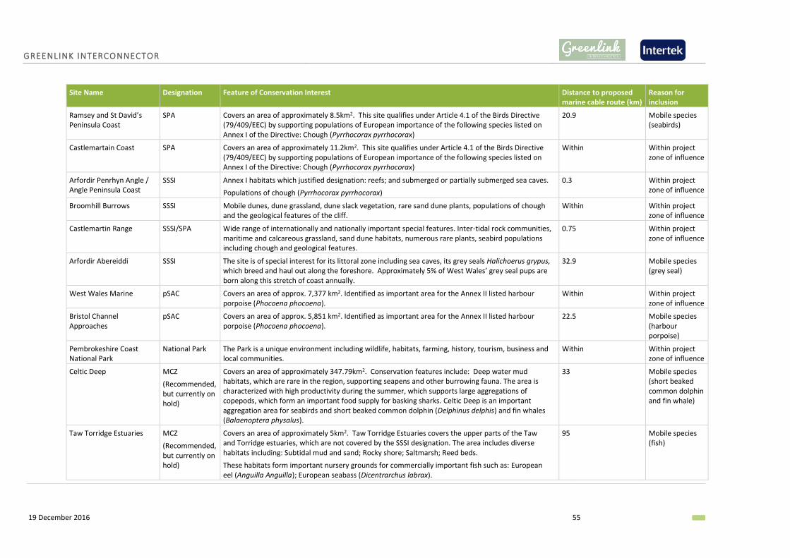
GREENLINK INTERCONNECTOR
19 December 2016 55
Site Name Designation Feature of Conservation Interest Distance to proposed marine cable route (km)
Reason for inclusion
Ramsey and St David’s Peninsula Coast
SPA Covers an area of approximately 8.5km2. This site qualifies under Article 4.1 of the Birds Directive (79/409/EEC) by supporting populations of European importance of the following species listed on Annex I of the Directive: Chough (Pyrrhocorax pyrrhocorax)
20.9 Mobile species (seabirds)
Castlemartain Coast SPA Covers an area of approximately 11.2km2. This site qualifies under Article 4.1 of the Birds Directive (79/409/EEC) by supporting populations of European importance of the following species listed on Annex I of the Directive: Chough (Pyrrhocorax pyrrhocorax)
Within Within project zone of influence
Arfordir Penrhyn Angle / Angle Peninsula Coast
SSSI Annex I habitats which justified designation: reefs; and submerged or partially submerged sea caves.
Populations of chough (Pyrrhocorax pyrrhocorax)
0.3 Within project zone of influence
Broomhill Burrows SSSI Mobile dunes, dune grassland, dune slack vegetation, rare sand dune plants, populations of chough and the geological features of the cliff.
Within Within project zone of influence
Castlemartin Range SSSI/SPA Wide range of internationally and nationally important special features. Inter-tidal rock communities, maritime and calcareous grassland, sand dune habitats, numerous rare plants, seabird populations including chough and geological features.
0.75 Within project zone of influence
Arfordir Abereiddi SSSI The site is of special interest for its littoral zone including sea caves, its grey seals Halichoerus grypus, which breed and haul out along the foreshore. Approximately 5% of West Wales’ grey seal pups are born along this stretch of coast annually.
32.9 Mobile species (grey seal)
West Wales Marine pSAC Covers an area of approx. 7,377 km2. Identified as important area for the Annex II listed harbour porpoise (Phocoena phocoena).
Within Within project zone of influence
Bristol Channel Approaches
pSAC Covers an area of approx. 5,851 km2. Identified as important area for the Annex II listed harbour porpoise (Phocoena phocoena).
22.5 Mobile species (harbour porpoise)
Pembrokeshire Coast National Park
National Park The Park is a unique environment including wildlife, habitats, farming, history, tourism, business and local communities.
Within Within project zone of influence
Celtic Deep MCZ
(Recommended, but currently on hold)
Covers an area of approximately 347.79km2. Conservation features include: Deep water mud habitats, which are rare in the region, supporting seapens and other burrowing fauna. The area is characterized with high productivity during the summer, which supports large aggregations of copepods, which form an important food supply for basking sharks. Celtic Deep is an important aggregation area for seabirds and short beaked common dolphin (Delphinus delphis) and fin whales (Balaenoptera physalus).
33 Mobile species (short beaked common dolphin and fin whale)
Taw Torridge Estuaries MCZ
(Recommended, but currently on hold)
Covers an area of approximately 5km2. Taw Torridge Estuaries covers the upper parts of the Taw and Torridge estuaries, which are not covered by the SSSI designation. The area includes diverse habitats including: Subtidal mud and sand; Rocky shore; Saltmarsh; Reed beds.
These habitats form important nursery grounds for commercially important fish such as: European eel (Anguilla Anguilla); European seabass (Dicentrarchus labrax).
95 Mobile species (fish)

GREENLINK INTERCONNECTOR
19 December 2016 56
5.5.2 IDENTIFICATION OF KEY SENSITIVITIES AND POTENTIAL IMPACTS
5.5.2.1 KEY SENSITIVITIES
▪ West Wales Marine and Bristol Channel Approaches pSACs important for harbour porpoise
populations.
▪ Pembrokeshire Marine SAC is an important area for grey seal, shore dock and otter populations.
▪ Skomer MCZ for its biodiversity.
▪ Skokholm and Skomer SPA important for bird species.
5.5.2.2 POTENTIAL IMPACTS
The potential impacts on protected sites will vary depending on the nature of the interest features
they are designated for. A protected site may include interest features from more than one receptor
group and the sensitivity of the interest features may vary according to receptor type. Potential
impacts on individual interest features will be covered in detail within each of the relevant receptor
topic chapters.
To determine the overall significance of the impact on the protected site, and in accordance with the
requirements of The Conservation of Habitats and Species Regulations 2012 (as amended) (the
Habitats Regulations) it will be necessary to undertake a Habitats Regulation Assessment (HRA) (see
Section 3.1.5). This will take the form of a Stage 1 screening assessment, which for each Natura 2000
site will look to answer the question “Is the proposal likely to have a significant effect on the site?”.
It is proposed that the HRA will be presented in the EA.
5.5.3 ENVIRONMENTAL APPRAISAL APPROACH
Table 5-9 Protected sites EA approach
Data Requirement Method Data Sources
Desk based review A desk based review of publicly available data will be used to describe all existing and potential designated sites. A Habitats Regulation Assessment (HRA) screening report will be prepared to assess whether any likely significant effects on the interest features of Natura 2000 sites will occur as a result of the project activities.
JNCC, NRW
Marine survey Benthic and if required, intertidal surveys, will identify any areas which contain PAIH.
Benthic survey
Consultation Existing useful data, local knowledge on Annex I habitats, updated information on progress of sites recommended for designation.
JNCC, NRW, BTO, RSPB
GREENLINK INTERCONNECTOR
19 December 2016 57
6. HUMAN ENVIRONMENT
6.1 COMMERCIAL FISHERIES
6.1.1 EXISTING BASELINE
Commercial fishing in the Irish and Celtic Sea is widely distributed and of the fisheries that are active,
demersal and shellfish are the most important. Demersal target species include; cod, haddock, ling,
monkfish, plaice, ray, skate and sole black whilst shellfish species include; Norwegian lobster, crabs,
scallops, razors and whelks. Pelagic fish landings from this area are mainly of herring and mackerel,
and of relatively less economic importance.
The closest fishing port to the project area is the Port of Milford Haven. In 2014, the number of
fishing vessels registered to the Port of Milford Haven was 466, 91% of which were 10m and under.
The number of fishermen based in the port was 850. From 2002 to 2014, the number of vessels
targeting demersal species in ICES sub-area VII (i.e. the region through which the proposed marine
cable route passes) fell by 28% due to decommissioning schemes, limited fishing opportunities and
quota controls. In 2014, 900 tonnes of demersal fish and 1000 tonnes of shellfish were landed at
this port representing values of £2.4 million and £1.6 million respectively (MMO 2014).
Fisheries within the Celtic Seas are managed through the EU Common Fisheries Policy (CFP) with
fisheries of some stocks managed by the North East Atlantic Fisheries Commission (NEAFC) and by
coastal state agreements.
6.1.2 IDENTIFICATION OF KEY SENSITIVITIES AND POTENTIAL IMPACTS
6.1.2.1 KEY SENSITIVITIES
▪ Important fishing grounds: Offshore trawling for plaice and other important flatfish bycatches.
▪ Any high density areas of static gear.
6.1.2.2 POTENTIAL IMPACTS
Displacement of fishing activity: Fishermen may have reduced access to their fishing grounds during
cable installation, repair and maintenance due to the mobile safety exclusion zone around the cable
installation, repair and maintenance spread. As the exclusion zone moves with the installation vessel
spread, potential impacts will be temporary and restricted to this relatively small zone. There is also
the possibility that if fixed gear such as pots are within the project area they may need to be
temporarily moved. This will be considered in further detail by the EA.
Reduction in water depth: Use of cable protection e.g. rock berms in water depths of less than 30m
has the potential to reduce chart datum by more than 5%; the threshold currently advised by the
Maritime and Coastguard Agency as acceptable. The EA will consider whether cable protection (if
proposed) has the potential to adversely affect the ability of vessels to navigate safely.

GREENLINK INTERCONNECTOR
19 December 2016 58
Loss or damage to fisheries habitats/fish stocks: As a result of the loss or disturbance of benthic
habitat and fish and shellfish species, there is potential for an indirect impact to the commercial
fisheries resource within the footprint of the proposed marine cable. This is unlikely to be significant
but will be considered in more detail in the EA.
Compass deviation from emission of electromagnetic fields: The generation of EMF could cause a
small localised compass deviation in ships using magnetic compasses (or with autohelm controlled
by magnetic compasses). Impacts of this effect could result in a navigational and safety risk to
mariners. This will be assessed in the EA.
Contamination of stock: Fish and aquaculture stock could potentially be contaminated through two
impact-receptor pathways; the creation of a sediment plume by activities which disturb the seabed
e.g. ploughing and jet-trenching; and the unplanned release of hydrocarbons or chemicals. An
increase in turbidity from installation plumes has the potential to contaminate shellfish species such
as mussels and oysters. Changes to water quality, including the suspended particulate matter load,
resulting from installation and maintenance operations are typically within normal environmental
variability. Changes will be temporary and restricted to the immediate vicinity of the cable. This is
unlikely to cause significant impacts to commercial aquaculture but will be considered in more detail
in the EA.
The likelihood of a hydrocarbon spill from a project vessel is the same as from general shipping in the
region. The potential significance of any impacts on fish stocks will be assessed in the EA.
Snagging resulting from obstructions on the seabed: Certain project activities have the potential to
create temporary and longer term obstructions on the seabed. The introduction of new obstructions
has the potential to increase the risk of gear snagging. This will be considered in more detail in the
EA.
6.1.3 ENVIRONMENTAL APPRAISAL APPROACH
Table 6-1 Commercial fishing EA approach
Data Requirement Method Data Sources
Desk based review The specialist fisheries study will be supplemented with catch statistics to provide the baseline along the proposed marine cable route.
Cefas sensitivity maps (Coull et al 1998 and Ellis et al 2012);
ICES Landing statistics.
Baseline study A specialist study will be undertaken to identify key fishing grounds, seasons and activities. It will identify possible economic impacts of the project, provide analysis of catch landing statistics and review other publically available data.
Specialist commercial fisheries study
Consultation Meetings with fishing industry organisations and representatives.
The National Federation of Fishermen’s Organisations (NFFO);
Inshore Fisheries and Conservation Authorities (IFCA).

GREENLINK INTERCONNECTOR
19 December 2016 59
6.2 SHIPPING AND NAVIGATION
6.2.1 EXISTING BASELINE
The proposed marine cable route passes through UKCS oil and gas quadrats 103 and 102; shipping
density in this area is described as very low in relation to the UKCS as a whole. However, the
proposed marine cable route passes through the south-westerly corner of the ‘Off Smalls’ traffic
separation zone (TSS) (Figure 6-1). The TSS is located west of The Smalls and is an area where
navigation of ships is highly regulated with the aim of creating lanes in the water with ships specific
to a lane all going roughly in the same direction. This is to regulate the busy waterways and help
reduce congestion whist entering or leaving the Port of Milford Haven. This area is adopted by the
International Maritime Organisation.
There are multiple navigation lines on the approach to the Port of Milford Haven. Defined anchoring
areas are restricted to sites mapped in Figure 6-1.
A shipping and navigation risk assessment will be undertaken to inform the EA.
6.2.2 IDENTIFICATION OF KEY SENSITIVITIES AND POTENTIAL IMPACTS
6.2.2.1 KEY SENSITIVITIES
▪ Shipping routes
6.2.2.2 POTENTIAL IMPACTS
Displacement of vessels: The presence of the mobile safety exclusion zone around the vessel spread
during cable installation, repair and maintenance has the potential to disrupt shipping activity.
Vessels may be required to alter planned routes. The significance of the impact on shipping will be
assessed by the EA.
Reduction in water depth: Use of cable protection e.g. rock berms in water depths of less than 30m
has the potential to reduce chart datum by more than 5%; the threshold currently advised by the
Maritime and Coastguard Agency as acceptable. The EA will consider whether cable protection (if
proposed) has the potential to adversely affect the ability of vessels to navigate safely.
Risk of ship collisions: It is recognised that ship to ship collisions could potentially occur. All vessels
will comply with the International Regulations for Preventing Collisions at Sea 1972 and as such the
potential impact is considered to relate to safety, outside of the scope of this assessment. It is
therefore proposed that that this impact is scoped out of the EA at this stage.
Accidental anchoring or emergency anchoring on unburied / buried cable: During installation there
is the potential for a ship to accidentally anchor over unburied cable prior to its burial, snagging the
anchor and resulting in potential damage to the ship. There is also a potential risk that a ship
anchoring in the vicinity of the marine cables may drag anchor towards and over the cable. The
likelihood of a commercial vessel accidentally releasing its anchor in close proximity to the marine
cables is low, as the cables represent a small surface area of a larger area in which vessels can
operate. Incidents of accidental anchoring whereby a cable is struck have been reported, but these

GREENLINK INTERCONNECTOR
19 December 2016 60
are typically been in close proximity to offshore structures such as platforms where the ratio of
surface areas of cables to operating area of the vessel is higher. Given the low likelihood of an
incident occurring it is proposed that this impact is scoped out of the EA at this stage.
EMF interference with navigation systems: The EMF that will be generated by the marine cables
during operation will have a localised effect which could potentially cause compass deviation in
vessels using magnetic compasses. Commercial vessels and military craft using inertial navigation
systems and GPS have negligible sensitivity to EMF as they are unaffected by external magnetic
fields. Few commercial vessels operate solely using magnetic compasses but they may still be used
as an auxiliary navigation system. This impact will therefore be given consideration by the EA.
6.2.3 ENVIRONMENTAL APPRAISAL APPROACH
Table 6-2 hipping and navigation EA approach
Data Requirement Method Data Sources
Desk based review The navigation and shipping baseline will be primarily based on the results of a specialist study.
Seazone digital data.
Admiralty charts.
Pilotage guides.
Automatic Information System (AIS) data
Baseline study A specialist study will provide data on maritime activity, shipping intensity and density in the study area and a risk assessment of potential shipping hazards such as collision risk and anchoring risks.
Shipping study and navigation risk assessment.
Consultation Consultation with key ports and the Maritime and Coastguard Agency (MCA) and other maritime stakeholders.
Port of Milford Haven, Trinity House, MCA.

.
Created ByReview ed By
Jennifer ArthurEmma Langley
Friday, December 16, 2016 15:19:10WGS_1984_UTM_Zone_30N
D_WGS_1984Seazone, DECC, OSOD, WavehubJ:\P1975\Mxd\Scoping Report\Report Figures\Human_Environment_UK.mxd
WGS_1984
DateProjection
Datu mData Sou rce
File Reference
Sph eroid
NOTE: Not to be used for Navigation
© SeaZone Solutions, 2016, 092015.0007.
Approved By Anna Farley
!>!>
!>
!>
!>
300000
300000
325000
325000
350000
350000
5700000
5700000
5725000
5725000
5750000
5750000
LegendProposed Cable Route
Median Line12nm limit
!> WellOffshore InstallationsNavigation LinesTraffic Separation SchemeMilitary Practice AreasDumping GroundsWrecksWavehub Site
0 3 6 9 12 15km
. Figure 6-1 Anthropogenic activities within closeproximity to the proposed marine cable route
Greenlink InterconnectorEnvironmental Scoping Report –
UK Marine Rou te
© Metoc Ltd, 2016.All righ ts reserved.

GREENLINK INTERCONNECTOR
19 December 2016 62
6.3 INFRASTRUCTURE AND OTHER USERS
6.3.1 EXISTING BASELINE
6.3.1.1 MINISTRY OF DEFENCE
The Castlemartin firing range is positioned to the south of the Milford Haven Waterway with the
military practice area covering approximately 24km2. The ranges are active for 44 weeks of the year
and when in use can include a coastal exclusion zone of 22km off the coast or as little as 5.6km
depending on equipment used (MHPA 2016). This exclusion zone restricts leisure boating and
anchorage in the area. The proposed marine cable route passes through the northern boundary of
this range as shown in Figure 6-1. There are no other military practice areas within the vicinity of the
proposed marine cable route.
6.3.1.2 DISPOSAL SITES
Dumping grounds are shown on Figure 6-1; these areas can be open/current or closed/historic and
are typically designated for dumping of dredged material or ship waste but can also include chemical
or munition waste. The dumping ground within close proximity to the proposed cable route was
historically used for disused explosives.
Consultation with the Port of Milford Haven alongside the Crown Estate conflict check identified that
the site closest to the harbour entry is closed. The proposed marine cable has been routed to avoid
the area.
6.3.1.3 OIL AND GAS INFRASTRUCTURE
There are ten abandoned wells in the lower section of the Celtic Sea, dating back to 1974.
Abandoned wells are left capped with no structures above the seabed. None are in the immediate
vicinity of the proposed marine cable route.
6.3.1.4 PIPELINES AND CABLES
Pipeline and cable crossings have been avoided where route development associated with avoiding
them has not significantly increased in route length. Minimising crossings has two benefits:
▪ Improved cable security; and
▪ Potential installation cost savings.
The proposed marine cable route crosses the active UK-Ireland crossing (Seg B) telecom cable which
runs between Ballinsker, Ireland to Crooklets Bay, UK shown on Figure 6-1. No pipelines have been
identified in the region.
6.3.1.5 OTHER MARINE DEVELOPMENTS
There are no marine aggregate extraction sites or windfarms (proposed, in construction or in
operation) in the vicinity of the proposed marine cable route.

GREENLINK INTERCONNECTOR
19 December 2016 63
Wave Hub Ltd wave energy demonstration zone is located 13km (at the closest point) off the South
Pembrokeshire coastline approximately 16km from the proposed marine cable route (Figure 6-1).
The zone covers a 90km2 area of seabed with an aim to help marine energy developers test in open
sea conditions.
6.3.1.6 TOURISM AND RECREATION
The Pembrokeshire coast has some of the best and most attractive resources in the UK for coastal
tourism and leisure. Pembrokeshire tourism has grown to become the largest and most proactive
tourist association in Wales. In 2009, the value of tourism in Wales was placed at 6.18 billion, 13.3%
of the nation’s gross domestic product (Wales Tourism Alliance 2012).
The landfall at Freshwater West does not lie close to any settlements; however the excellent water
quality and beach still attracts tourists. This beach is popular with experienced surfers and is known
as one of the most consistent surfing spots in Wales holding waves up to around 6-8ft (Visit
Pembrokeshire 2016). The Welsh National Surfing Championships are regularly held at Freshwater
West around May.
Recreational cruising routes, general sailing and racing areas are also present off the Pembrokeshire
coast, as illustrated in Figure 6-2, with routes between Lands End and North Wales passing 10nm
offshore of the Pembrokeshire coast. Several large marinas are found within Milford Haven such as
the Milford Marina and Neyland Yacht Haven (DTI 2005c).

. Figure 6-2 RYA routes within close proximity of the proposed marine cable route
Created ByReviewed By
Jennifer ArthurEmma Langley
Tuesday, December 13, 2016 14:56:26WGS_1984_UTM_Zone_29N
D_WGS_1984DECC, UKDEAL, RYAJ:\P1975\Mxd\Scoping Report\Report Figures\Fig_6_2_RYA_Routes.mxd
WGS_1984
DateProjection
DatumData Source
File Reference
Spheroid
NOTE: Not to be used for Navigation
Contains Ordnance Survey Ireland data © OSi 2012. © Data reproduced under licence from the Royal Yachting Association. © Crown Copyright, 2015. All rights reserved. Licence No: EK001-1001-WEB105. Not to be used for Navigation.
Approved By Anna Farley
")
!(
Pembroke
Freshwater West
750000
750000
765000
765000
780000
780000
5730
000
5730
000
5745
000
5745
000
LegendProposed Cable RouteRYA ClubRYA Training CentreMarinaGeneral Boating Area
AIS IntensityLow
High
!( Landfall") Substation
0 2 4 6 8km
.
Drawing No.Scale 1:300,000
DN_P1795_LA_002_Rev_0
© Metoc Ltd, 2016.All rights reserved.
Greenlink InterconnectorEnvironmental Scoping Report -
UK Marine Route
GREENLINK INTERCONNECTOR
19 December 2016 65
6.3.2 IDENTIFICATION OF KEY SENSITIVITIES AND POTENTIAL IMPACTS
6.3.2.1 KEY SENSITIVITIES
▪ Castlemartin firing range
▪ UK-Ireland crossing (Seg B) active telecom cable.
▪ Wave Hub Ltd wave energy demonstration zone
▪ Recreational activities e.g. boating, diving, surfing, fishing, beach walking / sunbathing.
6.3.2.2 POTENTIAL IMPACTS
Displacement of military and recreational users of the sea: The main potential impact on military
vessels and tourism and recreation in the project area is temporary displacement from the project
area during cable installation, repairs and maintenance. This potential impact will be covered in the
shipping and navigation chapter and so will not be assessed separately within the EA. The potential
impact will be localised and short term and is not expected to result in any significant impacts so
long as stakeholders are consulted with early in the EA process.
Restricted access to the beach: There is a potential for some restriction of access to the beach at the
landfall site during cable installation. This may potentially impact visitors to the coastal area during
the holiday season. The EA will consider this impact in further detail.
Reduction in water depth: Use of cable protection e.g. rock berms in water depths of less than 30m
has the potential to reduce chart datum by more than 5%; the threshold currently advised by the
Maritime and Coastguard Agency as acceptable. The EA will consider whether cable protection (if
proposed) has the potential to adversely affect the ability of vessels to navigate safely.
EMF interference with navigation systems: There is the potential that EMF generated by the marine
cables during operation will have a localised effect which could potentially cause compass deviation
in vessels using magnetic compasses. This potential impact will be covered in the shipping and
navigation chapter and will not be assessed separately for recreational and military vessels.
Damage to or interference of an external cable asset: There is the potential for installation and
maintenance activities to damage the existing active cable, particularly at the crossing point. The
cable asset will be crossed at 90°. Cable crossing agreements between Greenlink and the third party
cable operator will include design and installation methods for crossing arrangements. Therefore
the potential for the installation of Greenlink to damage the existing asset is greatly reduced. It is
proposed that this potential impact is scoped out of the EA at this stage.
Sterilisation of seabed limiting development options: There is likely to be a development exclusion
area in place either side of the proposed marine cables once installed. This is to protect them from
interference from future development. However, it effectively sterilises the seabed from other
development and potentially could reduce development options for future projects. Potentially this
could be pertinent for the Wave Hub Ltd wave energy development zone which may require export
cables to land in future. Consideration will be given to this potential impact in the EA.

GREENLINK INTERCONNECTOR
19 December 2016 66
Unplanned release of hydrocarbons or chemicals leading to displacement of marine activities: The
presence of project vessels will marginally increase the risk of a pollution incident. Depending on the
nature and size of a spill this could potentially affect recreational sea users, displacing them from an
area whilst clean-up operations take place. This will be considered further in the EA.
6.3.3 ENVIRONMENTAL APPRAISAL APPROACH
Table 6-3 Infrastructure and other users EA approach
Data Requirement Method Data Sources
Desk based review A desk based review of publically available information will be used to describe the existing baseline and significance of impacts.
KISCA, UKDeal, SeaZone, RYA
Baseline study Geophysical survey data will be able to confirm the position of the cable asset.
Geophysical survey data
Consultation Consultation with asset owners/ operators will be undertaken to develop crossing agreements where appropriate.
Consultation with relevant recreational stakeholders.
Asset owners, RYA, Pembrokeshire Coast National Park Authority
6.4 MARINE ARCHAEOLOGY
6.4.1 EXISTING BASELINE
There are a significant number of wrecks in and around the proposed marine cable route. There are
no known wrecks designated for protection however further information through consultation and /
or an archaeological specialised study is required to provide a comprehensive baseline description.
Storms of 2014 have exposed numerous wreckages on Freshwater West beach. The ‘Upside Down
Wreak’ is present at low tide with timbers measuring approximately 15.5m x 3.5m. Records suggest
that 19 wrecks are located around the Freshwater West beach area (Cundy and Turner 2014).
Furthermore, these storms also lowered sand levels substantially exposing peat beds with some tree
stumps, fallen trees, roots and branches. The compacted peat deposits in this area have been dated
to 5250-4550 BC.
Geophysical and geotechnical data from the marine route survey will be reviewed and analysed by
an experienced marine archaeologist to provide a comprehensive archaeological baseline.
If the option to use open-cut trenching across the beach at Freshwater West is progressed, a site
walkover of the beach and intertidal area will be undertaken by a qualified and experienced
archaeologist.
6.4.2 IDENTIFICATION OF KEY SENSITIVITIES AND POTENTIAL IMPACTS
6.4.2.1 KEY SENSITIVITIES
▪ Palaeo-landscape features.
GREENLINK INTERCONNECTOR
19 December 2016 67
▪ Maritime wreck sites.
▪ Unknown wreck sites (aircraft or maritime).
▪ Submerged peat deposits.
6.4.2.2 POTENTIAL IMPACTS
Direct damage to archaeological asset: During cable installation, maintenance and repair there is a
potential that sites (e.g. shipwrecks, palaeo-landscapes) may be damaged and artefacts destroyed
within the immediate footprint of the works. The EA will consider the impact in further detail.
Indirect damage to archaeological asset: Potential indirect impacts arise when direct impacts have
effects beyond their primary footprint which can affect archaeological sites or materials some
distance away. These can include changes to erosion patterns or sediment transport as a result of
installation, maintenance or repair activities. These can have either negative effects e.g. increasing
the rate of deterioration of the asset as it is increasingly exposed or positive effects e.g. increasing
the sediment cover affording the asset additional protection. The EA will consider this impact in
further detail.
6.4.3 ENVIRONMENTAL APPRAISAL APPROVAL
Table 6-4 Marine archaeology EIA approach
Data Requirement Method Data Sources
Desk based review Desk based review Specialist study.
Baseline study Archaeological assessment of geophysical and geotechnical survey data to highlight areas of archaeological interest, assess potential impacts and identify appropriate mitigation measures.
Geophysical and geotechnical survey data
Consultation Request any relevant information on the potential for archaeological sensitivities.
CADW

GREENLINK INTERCONNECTOR
19 December 2016 68
7. IMPACT ASSESSMENT METHODOLOGY
7.1 INTRODUCTION
This section describes the approach and methodology that will be used for the EA. The proposed
project has three distinct phases: installation, operation and decommissioning. The EA will consider
the impacts from cable installation and operation, including maintenance and repair only. The final
requirements of decommissioning the interconnector will be assessed separately, towards the end
of project life.
The Environmental Report (ER) will report on the EA process, its findings and conclusions. It will set
out proposed mitigation measures to avoid or reduce the level of impact to an acceptable level.
7.2 BASIS OF THE ASSESSMENT
The EA methodology follows the principles of Environmental Impact Assessment and draws upon
numerous guidance documents and regulations, including:
▪ The Institute of Environmental Management and Assessment (IEMA) Guidelines for
Environmental Impact Assessment, 2004.
▪ The Chartered Institute of Ecology and Environmental Management (CIEEM) Guidelines for
Ecological Impact Assessment in Britain and Ireland: Marine and Coastal, 2010.
▪ Scottish Natural Heritage (SNH); A handbook on environmental impact assessment: Guidance for
Competent Authorities, Consultees and others involved in the Environmental Impact Assessment
(EIA) Process in Scotland, 2013.
7.3 ENVIRONMENTAL ASSESSMENT APPROACH
The assessment process will involve the following steps:

GREENLINK INTERCONNECTOR
19 December 2016 69
The steps are described in more detail below and will be followed and presented within the receptor
topics of the ER.
7.3.1 CHARACTERISATION OF THE EXISTING BASELINE
In order to assess the potential impacts resulting from the project it is necessary to first establish the
physical, biological, and human conditions that currently exist along and within the vicinity of the
submarine cable corridor.
A good understanding of the baseline for each environmental receptor will be achieved through four
activities:
▪ Review of primary baseline studies (field).
▪ Review of additional specialist baseline studies (desk-based).
▪ Detailed review of all secondary sources (i.e. existing documentation and literature).
▪ Stakeholder consultation.
The key data sources used to establish the baseline will be described in each topic Chapter.
For each receptor topic the baseline will be described in sequence following the submarine cable
corridor from the UK landfall to the UK median line.
7.3.2 ESTABLISH POTENTIAL IMPACTS AND ZONE OF INFLUENCE
Having established baseline conditions, the next step is to identify for each environmental receptor
(e.g. fish, birds, shipping, tourism) project activities which have the potential to interact with the
receiving environment and result in an impact. Activities undertaken during installation and
operation are considered in terms of their potential to directly or indirectly:
▪ Interact with the existing natural environment (including physical and biological elements) and /
or human environment in a manner that could alter the established baseline.
▪ Cause significant stakeholder concerns.
▪ Breach relevant legal standards, corporate environmental policy and management systems.
Both direct (resulting from a direct interaction between the project and the receiving environment)
and indirect (impacts which are not a direct result if the project, often produced away from or as a
result of complex pathway) impacts will be considered. Cumulative and in-combination impacts will
be assessed separately (see Section 7.3.10).
For each project activity its zone of influence – the spatial extent over which the activities are
predicted to have an impact on the receiving environment – will be established. This will vary for
different activities and for the different stages of the project (installation and operation).
Establishing the zone of influence for different activities and receptors will be undertaken
quantitatively where possible but also qualitatively where necessary based on the project

GREENLINK INTERCONNECTOR
19 December 2016 70
description, project experience and literature reviews. Zones of influence will be established in the
project description.
Receptors which occur outside the zone of influence and cannot or are unlikely to travel into the
zone (e.g. benthic communities) will be screened out from being impacted by the project.
Conversely, mobile species and other mobile receptors such sea users can travel into the zone of
impact and therefore be impacted by the project.
Zones of influence will be considered for each potential impact on the receptor. Where a number of
project activities have the same impact (e.g. pre-sweeping, pre-lay grapnel run, trenching, resulting
in seabed disturbance) or the installation technique has not been determined, the worst case spatial
extent will be applied.
7.3.3 CHARACTERISATION OF THE CHANGE AND IMPACT
In order to fully characterise an impact or level of change from baseline conditions the following
parameters will be considered. These parameters are used to define the magnitude of change or the
magnitude value for the impact based on the definitions provided in Table 7-1.
Table 7-1 Criteria for characterising the magnitude of the impact
Magnitude Value
Definition
High Long term (> 5 years) and/or regional level loss or major alteration to key elements /features of the baseline condition such that post development character/composition of baseline will be fundamentally changed.
Medium Medium term (1- 5 years) loss and/or local level change (greater than the project footprint) or alteration to one or more key elements/features of the baseline conditions such that post development character/composition of the baseline condition will be materially changed.
Low Short term (<1 year), site specific and/or minor shift away from baseline conditions. Changes arising from the alteration will be detectable but not material; the underlying character /composition of the baseline condition will be similar to the pre-development situation.
Negligible Very little change from baseline conditions. Change is barely distinguishable, approximating to a “no change” situation.
• The magnitude refers to degree of change to the baseline environmentcaused by the impact being described.
Scale of Change
• The extent of an impact is the full area over which the impact occurs.Spatial extent
• The duration is the period within which the impact is expected to last priorto recovery or replacement of the feature. Frequency refers to how oftenthe impact will occur.
Duration & Frequency

GREENLINK INTERCONNECTOR
19 December 2016 71
7.3.4 CHARACTERISATION OF THE RECEPTOR
The significance of an impact on a receptor or feature is characterised by the sensitivity,
recoverability and importance of the receptor or feature. Characterisation of the receptor is
achieved by balancing out these three considerations to determine the Receptors Value. Criteria
used for the assessment are presented in Table 7-2.
Table 7-2 Criteria for characterising the sensitivity of the receptor (receptor value)
Receptor Value
Definition
High Receptor has little or no ability to absorb change without fundamentally altering its character. For example:
Physical Biological Human
One or more combinations of: ▪ Receptor has low / no capacity
to return to baseline condition within project life e.g. low tolerance to change and low recoverability such as a physical feature formed over a geological time scale.
▪ The receptor is a designated feature of a protected site, or is rare or unique.
One or more combinations of: ▪ Receptor has low tolerance to
change e.g. the species population is likely to be killed or destroyed by the project activity (MarLin 2016).
▪ Recovery to baseline conditions over a very long period i.e. > 10 years or not at all (MarLin 2010).
▪ The receptor is a designating feature of an International protected site e.g. European Natura 2000 or RAMSAR site
▪ Receptor is very rare / unique / or ecologically important.
One or more combinations of: ▪ Receptor has low / no capacity
to return to baseline e.g. low tolerance to change and low recoverability such as loss of access with no alternatives.
▪ Damage to asset(s) e.g. at cable crossing, resulting in major financial consequences for the company.
▪ Receptor is economically valuable.
Medium Receptor has moderate capacity to absorb change without significantly altering its character; however some damage to the receptor will occur. For example:
Physical Biological Human
One or more combinations of: ▪ Receptor has intermediate
tolerance to change. ▪ Medium capacity to return to
baseline condition e.g. >5 of up to 10 years.
▪ The receptor is valued but not
One or more combinations of: ▪ Receptor has intermediate tolerance
to change e.g. some individuals of the species may be killed/destroyed by the project activity and the viability of a species population may be reduced (MarLin 2016).
One or more combinations of: ▪ Receptor has intermediate
tolerance to change e.g. loss of access but acceptable alternatives, alteration to route but with no significant economic consequences.
• The sensitivity of the receptor relates to its sensitivity/vulnerability tochange (including its capacity to accommodate change i.e thetolerance/intolerance of the receptor to change).
Sensitivity
• The ability of the receptor to return to the baseline state before theproject impact caused the change.
Recoverability
• The importance of the receptor or feature is a measure of the valueassigned to that receptor based on biodiversity and ecosystemservices, social value and economic value. Importance of the receptoris also defined within a geographical context, whether it is importantinternationally, nationally or locally important.
Importance
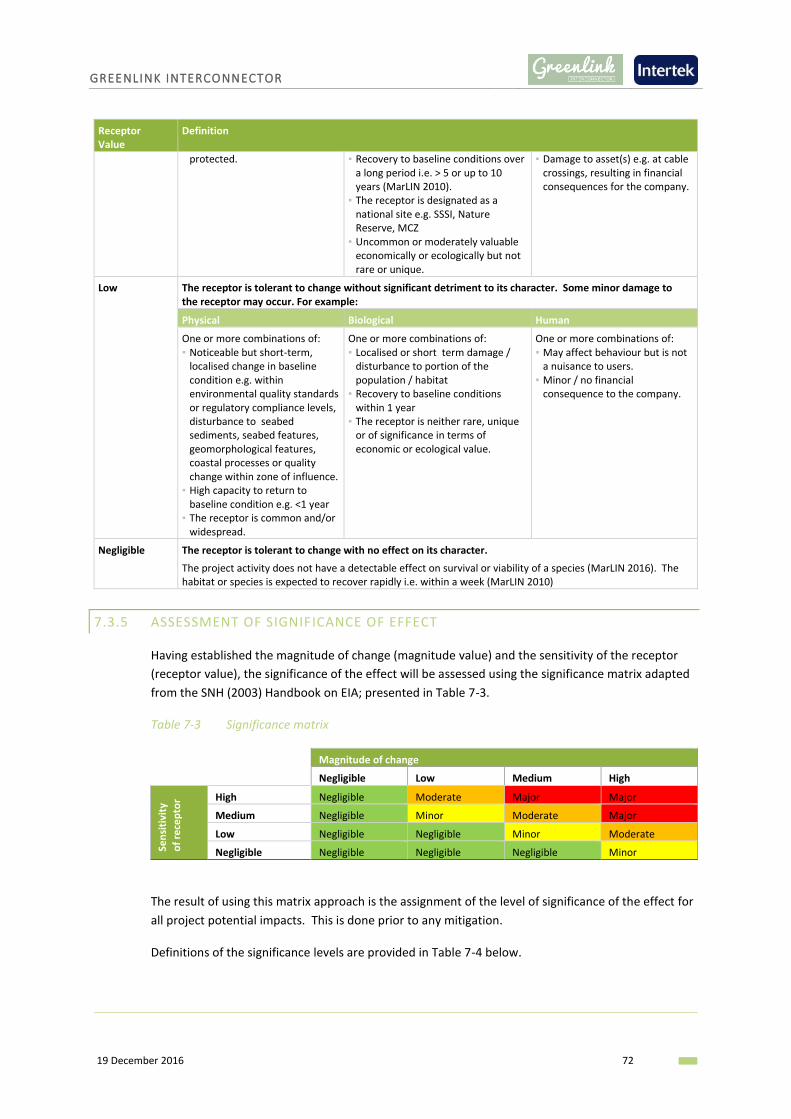
GREENLINK INTERCONNECTOR
19 December 2016 72
Receptor Value
Definition
protected. ▪ Recovery to baseline conditions over a long period i.e. > 5 or up to 10 years (MarLIN 2010).
▪ The receptor is designated as a national site e.g. SSSI, Nature Reserve, MCZ
▪ Uncommon or moderately valuable economically or ecologically but not rare or unique.
▪ Damage to asset(s) e.g. at cable crossings, resulting in financial consequences for the company.
Low The receptor is tolerant to change without significant detriment to its character. Some minor damage to the receptor may occur. For example:
Physical Biological Human
One or more combinations of: ▪ Noticeable but short-term,
localised change in baseline condition e.g. within environmental quality standards or regulatory compliance levels, disturbance to seabed sediments, seabed features, geomorphological features, coastal processes or quality change within zone of influence.
▪ High capacity to return to baseline condition e.g. <1 year
▪ The receptor is common and/or widespread.
One or more combinations of: ▪ Localised or short term damage /
disturbance to portion of the population / habitat
▪ Recovery to baseline conditions within 1 year
▪ The receptor is neither rare, unique or of significance in terms of economic or ecological value.
One or more combinations of: ▪ May affect behaviour but is not
a nuisance to users. ▪ Minor / no financial
consequence to the company.
Negligible The receptor is tolerant to change with no effect on its character.
The project activity does not have a detectable effect on survival or viability of a species (MarLIN 2016). The habitat or species is expected to recover rapidly i.e. within a week (MarLIN 2010)
7.3.5 ASSESSMENT OF SIGNIFICANCE OF EFFECT
Having established the magnitude of change (magnitude value) and the sensitivity of the receptor
(receptor value), the significance of the effect will be assessed using the significance matrix adapted
from the SNH (2003) Handbook on EIA; presented in Table 7-3.
Table 7-3 Significance matrix
Magnitude of change
Negligible Low Medium High
Sen
siti
vity
of
rece
pto
r High Negligible Moderate Major Major
Medium Negligible Minor Moderate Major
Low Negligible Negligible Minor Moderate
Negligible Negligible Negligible Negligible Minor
The result of using this matrix approach is the assignment of the level of significance of the effect for
all project potential impacts. This is done prior to any mitigation.
Definitions of the significance levels are provided in Table 7-4 below.

GREENLINK INTERCONNECTOR
19 December 2016 73
Table 7-4 Definitions of significance levels
Significance Definition
Negligible Generally considered as insignificant.
Minor Generally considered as insignificant and adequately controlled by best practice and legal controls. Opportunities to reduce effects further through mitigation may be limited and are unlikely to be cost effective.
Moderate Generally effects are those people are prepared to tolerate. However, it is expected that the residual effect has been subject to feasible and cost effective mitigation, and has been reduced to as low as reasonably practicable (ALARP) and that no further measures are feasible.
Major Generally regarded as unacceptable prior to any mitigation measures being considered.
The significance assessment is repeated taking into consideration the application of legal compliance
and appropriate mitigation. This determines whether there is likely to a residual impact. When
applied after mitigation, the resulting significance level is referred to as the residual significant
effect. Tables within the topic chapters will present the results of both assessments.
Residual effects assessed as moderate or major after consideration of proposed mitigation measures
will normally require additional analysis and consultation in order to discuss and possibly further
mitigate impacts where possible. Where further mitigation is not possible a residual effect may
remain.
7.3.6 UNPLANNED EVENTS
Unplanned events are incidents or non-routine events that have the potential to trigger impacts that
would otherwise not be anticipated during the normal course of installation or operation. The
severity of impact from the unplanned events of concern can be greater than the severity of
potential impacts associated with routine activities, however the probability of an unplanned event
occurring is typically much lower. Unplanned events which will be considered by the EA include:
▪ Hydrocarbon or chemical spill.
▪ Ship to marine mammal collision.
For unplanned events it is more appropriate to conduct a risk based assessment. Risk is a term in
general usage to express the combination of the likelihood of a specific impact occurring and the
severity of the consequences that might be expected to follow from it. The classifications used by
the assessment to determine likelihood and severity are provided in Table 7-5 and Table 7-6 below.
Table 7-5 Likelihood classifications - unplanned events
Likelihood Value Definition
Very Low Plausible during the life time of the project but no known occurrences in the industry
Low Plausible during the life time of the project and believed to have occurred in the industry
Medium Possible within the life time of the project - more than one incident per year in the UKCS
High Probable within the life time of the project i.e. several known occurrences per year in the UKCS
Source: Adapted from European Standard ISO 17776:2002 (BSI 2002)

GREENLINK INTERCONNECTOR
19 December 2016 74
Table 7-6 Severity classifications - unplanned events
Severity Value
Definition
Environment Business or Asset
Negligible No effects < £10k
Minor Minor significance effects
Oil spill Tier 1 Local assistance required
£10k - 100k
Moderate Moderate significance effects
Oil spill Tier 2 Limited external assistance required
£100k - 1M Local publicity
Major Major significance effects
Oil spill Tier 3 Regional assistance required
£1M - 10M National publicity
Severe Major significance effects
Oil spill Tier 4 National assistance required
> £10M International publicity
Having established the likelihood and severity values the risk can be determined using the below
matrix (Table 7-7).
Table 7-7 Risk matrix - unplanned events
Likelihood
Very Low Low Medium High
Seve
rity
Severe Tolerable Tolerable Unacceptable Unacceptable
Major Tolerable Tolerable Unacceptable Unacceptable
Moderate Acceptable Tolerable Tolerable Tolerable
Minor Acceptable Acceptable Acceptable Tolerable
Negligible Acceptable Acceptable Acceptable Acceptable
Source: Adapted from European Standard ISO 17776:2002 (BSI 2002)
The coloured zones in Table 7-7 indicate broad risk acceptability and tolerability levels as follows:
Table 7-8 Risk acceptability levels
Acceptable Risks are accepted without further reduction other than the routine management process of continual improvement.
Tolerable Risks which are accepted in a given context based on the current values of society. This generally means provided that the risks are reduced to as low as reasonably practicable (ALARP).
Unacceptable Risks cannot be justified under the current criteria. Strategy needs to be implemented to manage the risk.
Source: Adapted from HSE Framework for Decisions on the Tolerability of Risk in UKOOA
(1999)
Given the high potential severity of unplanned events, they typically require plans specifically
designed to respond to the event as quickly and effectively as possible. For cable installation and
operation, the responsibility generally lies with the vessel contractor to prepare and implement
plans and mobilise resources, although additional resources from external parties such as
government agencies are often an inherent part of the incident response.

GREENLINK INTERCONNECTOR
19 December 2016 75
7.3.7 ESTABLISH MITIGATION
Mitigation measures are the actions or systems proposed to manage or reduce the potential
negative impacts identified. Mitigation measures are sometimes confused with measures taken to
ensure legal compliance, which can be similar. Legislation is often designed to ensure impacts to the
environment are minimised. Legal compliance can therefore avoid or abate negative impacts.
Measures which are considered legal compliance will be listed within each topic Chapter as
appropriate.
Typically, mitigation measures are applied following the below hierarchy:
▪ Avoid or Prevent: In the first instance, mitigation should seek to avoid or prevent the adverse
effect at source for example, by routing the marine cables away from a sensitive receptor.
▪ Reduce: If the effect is unavoidable, mitigation measures should be implemented which seek to
reduce the significance of the effect.
▪ Offset: If the effect can neither be avoided nor reduced, mitigation should seek to offset the
effect through the implementation of compensatory mitigation.
Mitigation measures fall into two categories: mitigation which forms part of the project design; and
mitigation which is part of the construction and operation of the project. Mitigation measures which
form part of the design are an inherent part of the project and are considered the ‘base case’.
Mitigation measures which are to be adopted and implemented during the construction and
operation of the project are measures put in place to mitigate adverse effects, over and above legal
compliance.
Appropriate, feasible and cost effective mitigation measures will be proposed as necessary in each
topic Chapter.
7.3.8 ASSESSMENT OF SIGNIFICANCE OF RESIDUAL EFFECT
For those potential impacts which are determined to require project specific mitigation measures, a
further assessment will be made to determine if after the application of mitigation any residual
impacts will remain. The assessment process described above will be repeated to determine the
significance of the residual effect.
7.3.9 CUMULATIVE IMPACTS
The EA will give consideration to cumulative and indirect impacts and interactions. For the purposes
of the assessment, the definitions proposed by the European Commission (1999) will be used. The
definitions are as follows:
▪ Indirect Impacts (secondary impacts) – Impacts on the environment, which are not a direct result
of the project, often produced away from or as a result of a complex pathway.
▪ Cumulative Impacts – Impacts that result from incremental changes caused by other past,
present or reasonably foreseeable actions together with the project.
▪ Impact Interactions – The reactions between impacts whether between the impacts of just one
project or between the impacts of other projects in the area.

GREENLINK INTERCONNECTOR
19 December 2016 76
For the purposes of the EA, the potential impacts of the development are considered in terms of
impacts on each of the discrete environmental topic areas. In reality, topic areas such as ‘water
quality’ or ‘ecology’ cannot always be considered in isolation since changes affecting one factor may
often have secondary implications for other areas. Thus, if one impact of the development is to alter
the quality of a watercourse, flora and fauna may be affected as a secondary effect. The EA will
identify and assess potential indirect or cumulative impacts and interactions between environmental
topic areas.
The assessment of cumulative impacts will be dependent on the public availability of consented
developments. It is generally acknowledged that there are difficulties in assessing cumulative
impacts via a single-project EA.
Cumulative effects resulting from the connection of the onshore cables will also be assessed.
7.3.10 TRANSBOUNDARY ASSESSMENT
Projects may affect environmental receptors over several maritime jurisdictions. Impact
assessments are required to cover the zone of influence irrespective of administrative boundaries to
inform authorities of potential effects.
Greenlink traverses two maritime jurisdictions (UK and Ireland) and as such transboundary
assessment will be an integral component of the environmental assessment. It is not envisaged that
the project will impact other maritime jurisdictions. However, if the assessment identifies a
potential interaction the transboundary effects will be discussed.
7.4 STRUCTURE OF THE ENVIRONMENTAL REPORT
An Environmental Report will be compiled which will report on the EA process, its findings and
conclusions. It will be divided in the principle chapters outlined in Table 7-9.
Table 7-9 Structure of the Environmental Report
Chapter Title Content
0 Executive Summary The aim of the Executive Summary is to enable communication with those unfamiliar with the environmental appraisal process and terminology by summarising the key findings of the ER in simple terms.
1 Introduction An introduction describing the developer, need for the project and summarising the project.
2 Policy and Legislative Framework
A description of the legislative frameworks which govern the project and the environmental appraisal.
3 Development of the Project and Alternatives
This chapter outlines why the project is preferable to alternative options.
4 Scoping and Consultation This chapter will present an overview of the results of the scoping consultation, and summarise the technical studies and specific surveys that have been undertaken to inform the EA.
5 Project Description A description of the project in terms of the activities that will be undertaken and emissions to the environment during construction and operation of Greenlink.
6 Impact Assessment A description of the process followed when conducting the
GREENLINK INTERCONNECTOR
19 December 2016 77
Chapter Title Content
Methodology environmental appraisal.
7 Benthic and Intertidal Ecology
These chapters describe the physical, biological and human baseline environment in the project area including identification of key receptors and their sensitivity to possible impacts. The findings of the environmental appraisal are reported, which takes into consideration the nature, magnitude, duration of the potential impacts in order to determine their significance. If necessary, appropriate mitigation measures to avoid, reduce or remedy the effects identified are described.
The chapters are informed by the relevant studies and surveys undertaken by the project.
8 Fish and Shellfish
9 Birds
10 Marine Mammals and Reptiles
11 Protected Sites
12 Commercial Fisheries
13 Shipping and Navigation
14 Infrastructure and Other Users
15 Marine Archaeology
Cumulative and Transboundary Effects
Possible impacts from the overall scheme in combination with other power cable developments as well as other types of development in the vicinity will be assessed.
16 Schedule of Mitigation This chapter outlines the mitigation measures proposed in the assessment, and the minimum requirements contractors will need to take in order to implement them.
17 Conclusions This chapter provides overall conclusions on the significance of any impacts, proposed mitigation and how measures will be implemented.
- Appendices As required, but may include consultation feedback report, appropriate technical reports, key opinions from regulators on TEN-E process requirements.

GREENLINK INTERCONNECTOR
19 December 2016 78
8. SUMMARY OF ASSESSMENT
An Environmental Report will be produce which will summarise the results of the EA of the project
including the potential for cumulative effects.
It is considered that the EA will provide a robust assessment of the potential impacts of the project
on the environment by:
▪ Establishing an reviewing the existing environmental conditions along the marine cable route and
within the surrounding area;
▪ Identify and assess any environmental impacts associated with the proposed project; and
▪ Identify appropriate, feasible and cost effective measures to mitigate any significant impacts (if
identified).
In order to determine the appropriate scope of the EA, a scoping study has been undertaken. Within
the physical, biological and human environment sections of this scoping study, a high level
preliminary assessment has been made to:
▪ Determine what the key sensitivities are (if any) per receptor group;
▪ Identify potential impacts on these receptors; and
▪ Determine the likely significance of the potential impacts.
Based on the findings of this scoping exercise, Table 8-1 presents a summary of the identified
potential impacts for each phase of the project and indicates which potential impacts are proposed
to be taken forward into the EA and which it is proposed to scope out.
As discussed previously, to determine the overall significance of any impacts on protected sites a
Habitats Regulation Stage 1 Screening Assessment will be undertaken and presented in the EA.
Table 8-1 Summary of potential impacts
Key for potential impact assessment
Significance of impact to be assessed in EA
x No or negligible impact – proposed scoped out of EA
Receptor Potential Impact Installation, Maintenance & Repair
Operation
Metocean conditions
Modifications of metocean regime x x
Change to seabed temperature x x
Physical conditions
Changes to seabed bathymetry and seabed features x
Changes to sediment regime and coastal processes x x
Disturbance of natural seabed sediments
Disturbance of contaminated sediments
Change in water / sediment quality
Benthic and intertidal
Temporary habitat loss (intertidal & subtidal species)
Smothering of species
Introduction of new substrate
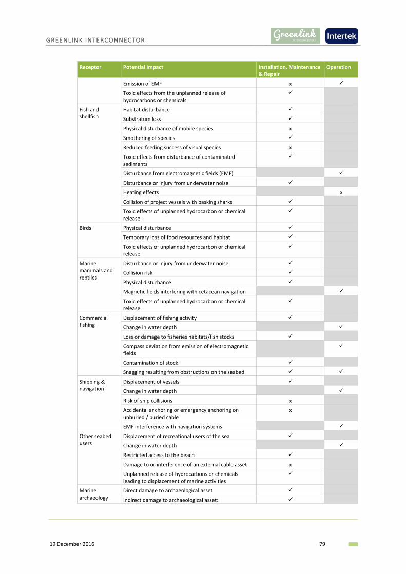
GREENLINK INTERCONNECTOR
19 December 2016 79
Receptor Potential Impact Installation, Maintenance & Repair
Operation
Emission of EMF x
Toxic effects from the unplanned release of hydrocarbons or chemicals
Fish and shellfish
Habitat disturbance
Substratum loss
Physical disturbance of mobile species x
Smothering of species
Reduced feeding success of visual species x
Toxic effects from disturbance of contaminated sediments
Disturbance from electromagnetic fields (EMF)
Disturbance or injury from underwater noise
Heating effects x
Collision of project vessels with basking sharks
Toxic effects of unplanned hydrocarbon or chemical release
Birds Physical disturbance
Temporary loss of food resources and habitat
Toxic effects of unplanned hydrocarbon or chemical release
Marine mammals and reptiles
Disturbance or injury from underwater noise
Collision risk
Physical disturbance
Magnetic fields interfering with cetacean navigation
Toxic effects of unplanned hydrocarbon or chemical release
Commercial fishing
Displacement of fishing activity
Change in water depth
Loss or damage to fisheries habitats/fish stocks
Compass deviation from emission of electromagnetic fields
Contamination of stock
Snagging resulting from obstructions on the seabed
Shipping & navigation
Displacement of vessels
Change in water depth
Risk of ship collisions x
Accidental anchoring or emergency anchoring on unburied / buried cable
x
EMF interference with navigation systems
Other seabed users
Displacement of recreational users of the sea
Change in water depth
Restricted access to the beach
Damage to or interference of an external cable asset x
Unplanned release of hydrocarbons or chemicals leading to displacement of marine activities
Marine archaeology
Direct damage to archaeological asset
Indirect damage to archaeological asset:

GREENLINK INTERCONNECTOR
19 December 2016 80
9. SCOPING QUESTIONS
The scoping report is the first formal stage in an on-going consultation process. The aim of this
round of consultation is to ensure that the scope of the EA is fit for its purpose to assess the
potential environmental impacts of the proposed project.
In order to help focus responses consultees are asked to consider the following questions in
particular:
▪ Has the project identified all regulatory requirements that need to be addressed during the
project EA?
▪ Does the scoping report identify all possible environmental receptor types that need to be
considered in the EA? If not, please identify any additional receptors you feel should be
considered.
▪ Have all likely and possible environmental effects been identified? If not, please identify any
further effects that you feel should be addressed.
▪ Do you agree with the scoping in/out of issues in Table 8-1?
▪ Does the list of proposed consultees in Appendix A reflect the range of stakeholders that should
be considered as consultees for this project? If not, please suggest any additional organisations
you feel should be consulted.
▪ Do you feel that the scope of supporting studies is adequate to inform a full assessment of
possible environmental impacts?
▪ Do you have any comments on the proposed data sources? Please identify any further data
sources you think may be relevant and useful.

GREENLINK INTERCONNECTOR
19 December 2016 81
10. REFERENCES
1 Barne, J.H., Robson, C.F., Kaznowska, S.S., and Doody, J.P., eds. (1995). Coasts and seas of the
United Kingdom. Region 12 Wales: Margam to Little Orme. Peterborough, Joint Nature Conservation
Committee.
2 British Standards Institute (BSI) (2002). Petroleum and natural gas industries – Offshore production
installations – Guidelines on tools for hazard identification and risk assessment. European Standard
ISO 17776:2002
3 CEFAS (2005). Provision of fishing activity data for the DTI Strategic Environmental Assessment 6.
4 Coull, K.A., Johnstone, R., and Rogers, S.I. (1998). Fisheries Sensitivity Maps for British Waters.
Published and distributed by UK Oil and Gas.
5 Countryside Council for Wales (CCW) (2005). Pembrokeshire Marine European Site. Advice
provided by the Countryside Council for Wales in fulfilment of Regulation 33 of the Conservation
(Natural Habitats, &c.) Regulations 1994.
6 Cundy, I and Turner, W. (2014). Survey and recording of an ‘Upside Down Wreck” on Freshwater
West beach, Pembrokeshire. Malvern Archaeological Diving Unit.
7 Davies, J. (1998). Bristol Channel and approaches (Cape Cornwall to Cwm yr Eglwys, Newport Bay)
(MNCR Sector 9). In Marine Nature Conservation Review. Benthic marine ecosystems of Great Britain
and the north-east Atlantic, ed. By K. Hiscock, 255-295. Peterborough, Joint Nature Conservation
Committee. (Coasts and seas of the United Kingdom. MNCR series).
8 DECC (2016). Marine and other mammals. Offshore Energy SEA 3: Appendix a Environmental
Baseline (pp 279 – 348).
9 DTI (2005a). SEA 6 Offshore Oil and Gas Licencing. Physical and Chemical Environment.
10 DTI (2005b). Synthesis of information on the benthos of area SEA 6.
11 DTI (2005c). Identifying Recreational Cruising Routes, Sailing and Racing Areas within SEA 6 Area.
A Report for the Department of Trade and Industry by the Royal Yachting Association.
12 DTI (2007a). SEA 8 technical report- Hydrography.
13 DTI (2007b). Synthesis of information on the benthos of area SEA 8.
14 DTI (2009a). Fish and Shellfish Environmental Baseline. Appendix A.3a.4.1.
15 DTI (2009b). Marine Reptiles. Environmental Baseline. Appendix A3a.5.
16 European Commission (1999). Guidance for the Assessment of Indirect and Cumulative Impacts
as well as Impact Interactions. May 1999. [Online]. Available at:
http://ec.europa.eu/environment/archives/eia/eia-studies-and-reports/pdf/guidel.pdf (Accessed
April 2016)
17 Forewind (2013). Dogger Bank Creyke Beck Environmental Statement Chapter 11 Appendix A-
Ornithology Technical Report. BTO Research Report No 630.
18 Furness, R.W. and Tasker, M.L. (2000). Seabird fishery interaction: qualifying the sensitivity of
seabirds to reductions in sandeel abundance, and identification of key areas for sensitive seabirds in
the North Sea. Marine Ecology Progress Series: 202, 253-264.
GREENLINK INTERCONNECTOR
19 December 2016 82
19 Hammond, P.S., Northridge, S.P., Thompson, D., Gordon J.C.D., Hall, A.J, Murphy, S.N. and
Embling C.B. (2008). Background information on marine mammals for Strategic Environmental
Assessment 8.
20 Institute of Ecology and Environmental Management (IEEM) (2010). Guidelines for Ecological
Impact Assessment in Britain and Ireland: Marine and Coastal, [Online] Available at:
http://www.cieem.net/data/files/Resource_Library/Technical_Guidance_Series/EcIA_Guidelines/Fin
al_EcIA_Marine_01_Dec_2010.pdf (Accessed April 2016)
21 Institute of Environmental Management and Assessment (IEMA) (2004). Guidelines for
Environmental Impact Assessment. Lincoln, p154.
22 JNCC (2016a). UK BAP Priority Marine Species. Available at: http://jncc.defra.gov.uk/page-5167
<Accessed 09/08/2016>
23 JNCC (2016b). Skokholm and Skomer SPA description. Available at:
http://jncc.defra.gov.uk/default.aspx?page=2061 <Accessed 08/08/2016>
24 MarLin (1999-2010). Sensitivity assessment methodology. [Online] Available at:
http://www.marlin.ac.uk/species/MarLIN-sensitivity-methods (Accessed April 2016)
25 MarLin (2016). Species intolerance. [Online] Available at:
http://www.marlin.ac.uk/glossary/intoleranceranking (Accessed April 2016).
26 MHPA (2016). Castlemartin Firing Range. Available at:
https://www.mhpa.co.uk/uploads/Marine_docs/Castlemartin_Firing_Range.pdf <Accessed
16/08/2016>
27 MMO (2014). UK Sea Fisheries Statistics. Available at:
https://www.gov.uk/government/uploads/system/uploads/attachment_data/file/462753/UK_Sea_F
isheries_Statistics_2014_-_online_version.pdf <Accessed 02/09/2016>
28 NMFS (2016). Technical Guidance for Assessing the Effects of Anthropogenic Sound on Marine
Mammals Hearing: Underwater Acoustic Thresholds for Onset of Permanent and Temporary
Threshold Shifts. US. Dept. of Commer., NOAA. NOAA Technical Memorandum NMFS-OPR-55, 178 p.
29 Pembrokeshire County Council (2016). Available at:
http://www.pembrokeshire.gov.uk/content.asp?nav=1626,2380,110,935&parent_directory_id=646
&id=28859 <Accessed 09/08/2016>.
30 Pembrokeshire Marine Special Area of Conservation (2016). Available at:
http://www.pembrokeshiremarinesac.org.uk/ <Accessed 03/08/16>
31 Reid, J.B., Evans, P.G.H. and Northridge, S.P. (2003).Atlas of Cetacean distribution in north-west
European waters. Joint Nature Conservation Committee, Peterborough, UK.
32 The Scottish Government (2014). Updating Fisheries Sensitivity Maps in British Waters. Scottish
Marine and Freshwater Science (Vol 5, No. 10). http://www.gov.scot/Resource/0046/00465795.pdf
33 Scottish Natural Heritage (SNH) (2013). A handbook on environmental impact assessment:
Guidance for Competent Authorities, Consultees and others involved in the Environmental Impact
Assessment (EIA) Process in Scotland. [Online] Available at:
http://www.snh.gov.uk/docs/A1198363.pdf (Accessed April 2016).

GREENLINK INTERCONNECTOR
19 December 2016 83
34 Stone, C.J., Webb, A., Barton, C., Ratcliffe, N., Reed, T.C., Tasker, M.L., Camphuysen, C.J. and
Pienkowski, M.W. (1995). An atlas of seabird distribution in northwest European waters. JNCC,
Peterborough.
35 Tappin, D.R., Chadwick, R.A., Jackson, A.A., Wingfield, R.T.R. and Smith, N.J.P. (1994). United
Kingdom offshore regional report, the geology of Cardigan Bay and the Bristol Channel. London:
HMSO for the British Geological Society.
36 UK Offshore Operators Association (UKOOA) (1999). A Framework for Risk Related Decision
Support. Issue 1, May 1999.
37 UKMMAS (2010). Charting Progress 2. An assessment of the state of UK seas. Available at:
http://www.gov.scot/Topics/marine/science/atlas/CP2
38 Visit Pembrokeshire (2016). Available at: http://www.visitpembrokeshire.com/explore-
pembrokeshire/beaches/freshwater-west/ <Accessed 04/08/2016>.
39 Wales Tourism Alliance (2012). Wales tourism definitive value report.

GREENLINK INTERCONNECTOR
19 December 2016 84
APPENDIX A – CONSULTEE LIST
List of all consultees to whom a copy of this scoping report has been sent requesting a Scoping
Opinion.
▪ British Ports Association (BPA)
▪ BTO
▪ Celtic Seas Partnership
▪ Centre for Environment, Fisheries and Aquaculture Science (Cefas)
▪ Chamber of Shipping
▪ Devon and Severn IFCA
▪ Joint Nature Conservation Committee (JNCC)
▪ Level 3 Communications Ltd
▪ Marine Management Organisation (MMO)
▪ Maritime & Coastguard Agency (MCA)
▪ Ministry of Defence
▪ Ministry of Defence – Castlemartin Firing Range
▪ National Federation of Fishermen’s Organisations (NFFO)
▪ Natural Resources Wales (NRW)
▪ Oil and Gas Authority (OGA)
▪ Pembrokeshire Coast National Park Authority
▪ Pembrokeshire County Council
▪ Port of Milford Haven
▪ Royal Society for the Protection of Birds (RSPB)
▪ Royal Yachting Association (RYA)
▪ Tenby and District Angling Club
▪ The Crown Estate
▪ The Royal Commission on the Ancient and Historical Monuments of Wales
▪ The Welsh Fishermen's Association
▪ The Wildlife Trust of South and West Wales
▪ Trinity House Lighthouse Service
▪ UK Association of Fish Producers Organisation
▪ Wave Hub Ltd

GREENLINK INTERCONNECTOR
19 December 2016 85
APPENDIX B – SCREENING OPINIONS

Lancaster HouseHampshire CourtNewcastle upon TyneNE4 7YH
T 0300 123 1032F 0191 376 2681www.gov.uk/mmo
Tom BrinicombeGreenwire Transmission Pembroke LtdUnit C Building 4200Cork Airport Business ParkCork, IrelandIreland
Case reference: EIA/2016/00041
7th November 2016 Dear Mr Brinicombe, The Marine Works (Environmental Impact Assessment) Regulations 2007 (asamended) ("the MWR")Request for a screening opinion - Greenlink Interconnector
Thank you for your marine licence enquiry dated 6 September 2016, requestinga Environmental Impact Assessment (EIA) Screening request from the MarineManagement Organisation (MMO) in respect of the Greenlink Interconnector project. Background
The MMO is required to consider such requests in accordance with the Marine Works(Environmental Impact Assessment) Regulations 2007 (as amended) ("the MWR").In doing so the MMO must determine whether the regulated activity proposed wouldconstitute a project which falls within Annex I or Annex II to European Directive 2011/92/EU ("the Directive").
An Environmental Impact Assessment ("EIA") is mandatory for projects falling withinAnnex I of the Directive.
Should the project be determined to be one which falls within Annex II of the Directive,consideration must be given to the nature of the project, having regard to its size,nature and location. In the event it is determined that the project is likely to give rise tosignificant effects on the environment an EIA will be required. MMO Screening Opinion On reviewing the information provided, I am of the opinion that the project does notfall within either Annex I or Annex II of the MWR. Greenlink Transmission PembrokeLimited will submit an Environmental Report in accordance with all relevant bestpractice, the Environmental Report will accompany marine licence applications toboth the MMO and Natural Resources Wales (NRW).
Lancaster HouseHampshire CourtNewcastle upon TyneNE4 7YH
T 0300 123 1032F 0191 376 2681www.gov.uk/mmo
Marine licensing requirements
Section 81 of Marine and Coastal Access Act 2009 (MCAA) states that a marinelicence is not required for laying or maintaining an offshore stretch of exempt submarinecable. However, a marine licence would be required under Part 4 of the MCAA for thedeposition of cable protection material as stated in your letter to the MMO dated 25August 2016.
Conclusion
The MMO is of the opinion that the project does not fall within Annex I or Annex II ofthe MWR, therefore, an EIA is not required. However, the proposed cable protectionworks will require a marine licence under Part 4 of the MCAA. Your feedback We are committed to providing excellent customer service and continually improvingour standards and we would be delighted to know what you thought of the serviceyou have received from us. Please help us by taking a few minutes to complete thefollowing short survey (https://www.surveymonkey.com/r/MMOMLcustomer). Finally, If you have any queries or require clarification on any of the above, thenplease do not hesitate to contact me. Yours sincerely, Rachel Rachel-Louisa Gardener
Marine Licensing Case OfficerD +44 (0)2082 256 657E [email protected]
SIGN_FIELD_1 SIGN_FIELD_1
SIGN_FIELD_1 SIGN_FIELD_1
Miss Rachel-Louisa Gardener+44 (0)2082 256 [email protected]

1
Anna Farley Intertek
From: Hudson, Jon <[email protected]>
Sent: 15 December 2016 10:00
To: Tom Brinicombe
Cc: Anna Farley Intertek; Pauls, Lily
Subject: RE: Screening
Hi Tom,
I agree that, on reviewing the information provided, the project does not fall within either Annex I or Annex II
of the MWR. I understand that Greenlink Transmission Pembroke Limited will submit an Environmental
Report in accordance with all relevant best practice and that the Environmental Report will accompany
marine licence applications to both the MMO and Natural Resources Wales (NRW).
NRW is of the opinion that the project does not fall within Annex I or Annex II and that therefore, an EIA is not
required. However, as pointed out by the MMO, the proposed cable protection works will require a marine
licence under Part 4 of the MCAA.
Regards Jon
From: Tom Brinicombe [mailto:[email protected]]
Sent: 15 December 2016 09:29
To: Hudson, Jon <[email protected]>
Cc: Anna Farley Intertek <[email protected]>
Subject: Screening
Hi Jon, I hope that you are getting on well. I understand that you are out on site today. I was wondering if you had an anticipated date for responding to our screening request? We are just finalising our scoping document and want to include that neither MMO nor NRW believe the project to be an EIA development. We can amend if required and apologies for chasing. Many thanks and all the best, Tom
Tom Brinicombe
Regus House Malthouse Avenue Cardiff Gate Business Park Cardiff
CF23 8RU