GREECE - European Commission regard to Maritime Spatial Planning (MSP) in Greece1. After detailing...
16
Country reports © European Commission study - 1- I. GREECE Disclaimer This document has not been adopted by the European Commission and should therefore not be relied upon as a statement of the European Commission. The purpose of this document is merely to provide a comprehensive overview based on available information without claiming to be exhaustive. Although stakeholder consultation has taken place to verify the collected information, it is possible that this document does not reflect the view of all stakeholders involved. This document has been updated until February 2011. This country report provides a comprehensive overview and assessment of the current state-of-play with regard to Maritime Spatial Planning (MSP) in Greece 1 . After detailing Greece’s country characteristics, its most important maritime activities are presented. Next, the country report discusses the legal aspects, key players, plans and projects related to Integrated Coastal Zone Management (ICZM) and Maritime Spatial Planning (MSP) as well as the cross-border initiatives and existing platforms for cooperation. To conclude, the main findings related to Maritime Spatial Planning are summed up. The sources of information used and persons contacted are listed at the end. I.1. COUNTRY CHARACTERISTICS Greece is an EU Member State in South-Eastern Europe and has a coastline on the Ionian Sea in the west, the Adriatic Sea in the northwest, the Aegean Sea in the east and the Eastern Mediterranean in the south and southeast. Greece is bordered by Albania in the northwest, Bulgaria and the Former Yugoslav Republic of Macedonia (FYROM) in the north and Turkey in the east. A summary of the most important country characteristics is presented in Table 1. . 1 For the purpose of this study 20 country reports have been drawn up in total. Relevant available information on Monaco is included in the case study of the Western Mediterranean and information on the United Kingdom (Gibraltar) is included in the case study of the Alboran Sea.
Transcript of GREECE - European Commission regard to Maritime Spatial Planning (MSP) in Greece1. After detailing...
Country reports
© European Commission study - 1-
I. GREECE
Disclaimer This document has not been adopted by the European Commission and should therefore not be relied upon as a statement of the European Commission. The purpose of this document is merely to provide a comprehensive overview based on available information without claiming to be exhaustive. Although stakeholder consultation has taken place to verify the collected information, it is possible that this document does not reflect the view of all stakeholders involved. This document has been updated until February 2011. This country report provides a comprehensive overview and assessment of the current state-of-play with regard to Maritime Spatial Planning (MSP) in Greece1. After detailing Greece’s country characteristics, its most important maritime activities are presented. Next, the country report discusses the legal aspects, key players, plans and projects related to Integrated Coastal Zone Management (ICZM) and Maritime Spatial Planning (MSP) as well as the cross-border initiatives and existing platforms for cooperation. To conclude, the main findings related to Maritime Spatial Planning are summed up. The sources of information used and persons contacted are listed at the end.
I.1. COUNTRY CHARACTERISTICS
Greece is an EU Member State in South-Eastern Europe and has a coastline on the Ionian Sea in the west, the Adriatic Sea in the northwest, the Aegean Sea in the east and the Eastern Mediterranean in the south and southeast. Greece is bordered by Albania in the northwest, Bulgaria and the Former Yugoslav Republic of Macedonia (FYROM) in the north and Turkey in the east. A summary of the most important country characteristics is presented in Table 1. .
1 For the purpose of this study 20 country reports have been drawn up in total. Relevant available information on Monaco
is included in the case study of the Western Mediterranean and information on the United Kingdom (Gibraltar) is included in the case study of the Alboran Sea.

Exploring the potential of maritime spatial planning in the Mediterranean
- 2 - © European Commission study
Greece has a 6 nm territorial sea in the Mediterranean Sea basin2, but has repeatedly declared that it reserves its legitimate right under international law to establish a 12 nm territorial sea at a time deemed appropriate3.
Table 1: Country characteristics – Greece
114 507
Area (km²)
East Macedonia, Central Macedonia, Epirus, Thessaly, Ionian Islands, West Greece, Peloponnese, Crete, South Aegean, North Aegean, Central Greece and Attica
Coastal regions*
Around 10 000 making up around 70% of the country’s coastlineIslands and islets****
Max. depth Aegean Sea: 2 658 mMax. depth Ionian Sea: 5 121 m
Water depth***
17 400 kmCoastline length**
6 nm/median lineTerritorial sea
BreadthMaritime zones*****
Greece
* Greece consists of 13 regions called peripheries (largest unit of government beneath the state). 12 of these peripheries can be consideredcoastal regions
** Source: Ministry of Environment, Energy and Climate Change, e-mail April 7, 2010*** Source: Britannica Online Encyclopedia, www.britannica.com**** Source: European Commission, EU Maritime Policy – Facts and Figures: Greece***** Based on the national acts or decrees of the maritime zones; EarthTrends, Coastal and Marine Ecosystems – searchable database; Ministry
of Environment, Energy and Climate Change, e-mail April 7, 2010
Source: Policy Research Corporation
I.2. MARITIME ACTIVITIES AND THE PROTECTION OF MARINE AREAS
Greece’s most significant maritime activities are maritime transport, marine and coastal tourism and fisheries. Although activities in Greece’s marine area are considerable, at present no significant competition in terms of space or impact is experienced. The Framework for Spatial Planning of Aquaculture4, which is currently under preparation, is expected to prevent possible competition between mariculture on the one hand and navigation and marine and coastal tourism on the other hand. Greece has the largest merchant fleet in the EU and one of the largest merchant fleets in the world. The country is surrounded by a rather large number of important shipping lanes (see Figure 1) and has
2 Greece also has a 10-mile territorial sea for the purposes of aviation and the control thereof, a right which it has
constantly exercised since 1931; c.f. Decree of 6/18 September 1931 to define the extent of the territorial sea for the purposes of aviation and the control thereof.
3 Ministry of Foreign Affairs, e-mail February 10, 2010. See, inter alia, article 2 of Law 2321/1995 approving the UN Convention on the Law of the Sea (1982) as well as the declaration made by Greece upon ratification of the Convention: “Greece secures all rights and assumes all the obligations deriving from the Convention. Greece shall determine when and how it shall exercise those rights, according to its national strategy. This shall not imply that Greece renounces these rights in any way.”
4 See Section I.4.

Country reports
© European Commission study - 3-
20 ports with more than one million tonnes of cargo per year, out of which the port of Piraeus is the most important one.
Figure 1: Major shipping routes near Greece
Source : Policy Research Corporation based on the Safemed Project – Maritime traffic flows and risks analysis in the Mediterranean Sea, www.safemedgis.org
Moreover, Greece is an attractive destination for cruise passengers. Greece’s ports are also used for purposes such as commercial shipping, recreational boating as well as ferry transportation. Given Greece’s unique geographical features and in particular its extensive insular territory, the country’s territorial and social cohesion depends directly on the existence of frequent and reliable coastal shipping services (serving 94 islands, 144 ports and around 36 million passengers per year). More information about maritime transport can be found in Table 2.
Table 2: Information about maritime transport
− 3 996 ships in controlled fleet (≥1 000 GT, ‘09)
− 969 ships under Greek flag (≥1 000 GT, ‘09)
− Ferry passengers ( cabotage ‘09): 64 648 474
− Largest merchant fleet in EU and in the world:
o 23.48% of EU fleet in gt (‘08)
o 13 % of the world’s gross tonnage (Greek-owned fleet, ’09)
− Important container ports (container throughput in TEU, ‘07): Piraeus: 1 373 000; Thessaloniki: 447 000
− Important cargo ports (metric tonnes, ‘07): Piraeus: 20 122 000; Thessaloniki: 8 466 000
− Seaborne passenger transport between ports (’07): 45 858 000
Source: Ministry of Environment, Physical Planning and Public Works
Greece is ranked 15th worldwide as a tourist destination. Tourism contributes more than 18% to the annual Gross National Product. Diving is believed to be the upcoming trend within the tourism
main routesmain oil tanker routes
Thicker and darker lines = more intense traffic

Exploring the potential of maritime spatial planning in the Mediterranean
- 4 - © European Commission study
sector5. The fisheries sector employs a significant number of persons (around 38 0006). The country’s fishing fleet is characterised by its large share of small-scale coastal vessels. In 2008 approximately 89 000 tons of fish were caught7. Mariculture activities in Greece are well-established and represent a high percentage of the European production and account for a large part of mariculture production in the Mediterranean8. Aquaculture production in Greece (which includes land-based aquaculture and mariculture) amounted to 115 000 tonnes in 20089. Greece is currently being connected to Italy via the IGI project (Interconnection Greece – Italy) for the import of natural gas in Italy through Greece. The IGI project forms part of a larger project, named the ITGI (Interconnection Turkey – Greece – Italy) project, which is a project of European interest. The IGI project (a pipeline of around 800 km) comprises an onshore (590 km) and an offshore section (207 km) called the Poseidon Pipeline. The Poseidon Pipeline will connect the Greek Ionian Coast (Thesprotia Prefecture) with the Italian Coast (Apulia Region). Moreover, Greece has one offshore oil and gas extraction plant (in the northern part of the country, close to the city of Kavala and the island of Thasos). In addition, Greece has a number of areas restricted for military use. With regard to the preservation of nature, Greece is active in establishing Marine Protected Areas (MPAs). According to the Network of Managers of Marine Protected Areas in the Mediterranean (MedPAN), four Greek MPAs are participating in the Network. Table 3 provides more insight into their marine and terrestrial area, their legal status and international recognition. Moreover, according to the most recent information available to the European Commission (GIS calculated values, mid-2009), the marine area designated as NATURA 2000 measures 6 382 km² in Greece10. Furthermore, plans are under way for the identification of new marine NATURA 2000 areas within the territorial waters of Greece. More than 300 islands and small islets (vrachonissides) of the Aegean Sea are included in the Natura 2000 network. Marine areas of the Network include approximately 28 000 ha of the priority habitat type Posidonia beds. Moreover, they include important habitats for endangered or critically endangered species like the loggerhead sea turtle and the Mediterranean monk seal. For the conservation of the two species, marine Natura 2000 sites have been designated as National Marine Parks (National Marine Park of Zakynthos and Alonissos – Northern Sporades respectively). Six National Parks include marine areas within their boundaries. All marine protected areas in these National Parks are managed by Management Bodies, consisting of local stakeholders and representatives of local and central competent authorities.
5 Greece has a significant number of underwater cultural heritage sites. 6 Data comprise employment in fishing, processing and mariculture sectors. 7 FAO, Yearbook of fishery statistics. 8 European Commission – DG Maritime Affairs and Fisheries, EU Maritime Policy – Facts and Figures: Greece. 9 FAO, Yearbook of fishery statistics. 10 European Commission – DG Environment, December 2009, NATURA 2000 area calculation.
Country reports
© European Commission study - 5-
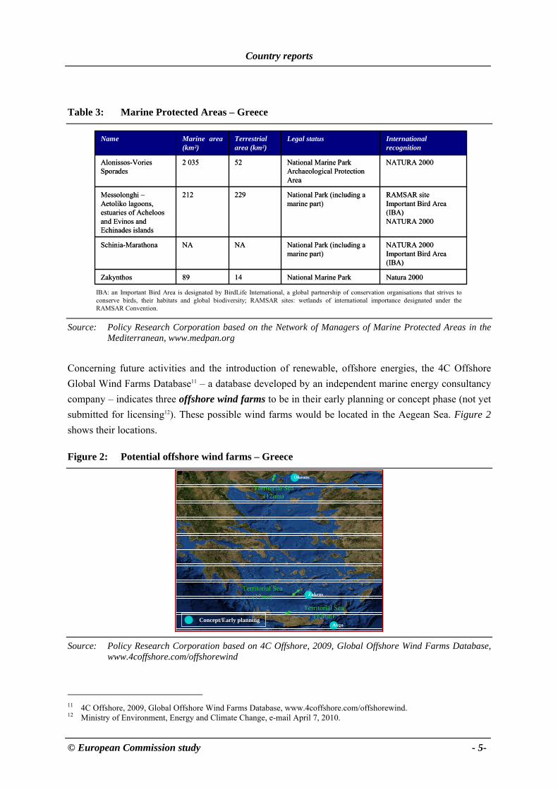
Table 3: Marine Protected Areas – Greece
Natura 2000National Marine Park1489Zakynthos
NATURA 2000Important Bird Area (IBA)
National Park (including a marine part)
NANASchinia-Marathona
RAMSAR siteImportant Bird Area (IBA)NATURA 2000
National Park (including a marine part)
229212Messolonghi –Aetoliko lagoons, estuaries of Acheloosand Evinos and Echinades islands
NATURA 2000National Marine ParkArchaeological Protection Area
522 035Alonissos-VoriesSporades
International recognition[1]
Legal statusTerrestrialarea (km²)
Marine area(km²)
Name
IBA: an Important Bird Area is designated by BirdLife International, a global partnership of conservation organisations that strives to conserve birds, their habitats and global biodiversity; RAMSAR sites: wetlands of international importance designated under the RAMSAR Convention.
Source: Policy Research Corporation based on the Network of Managers of Marine Protected Areas in the Mediterranean, www.medpan.org
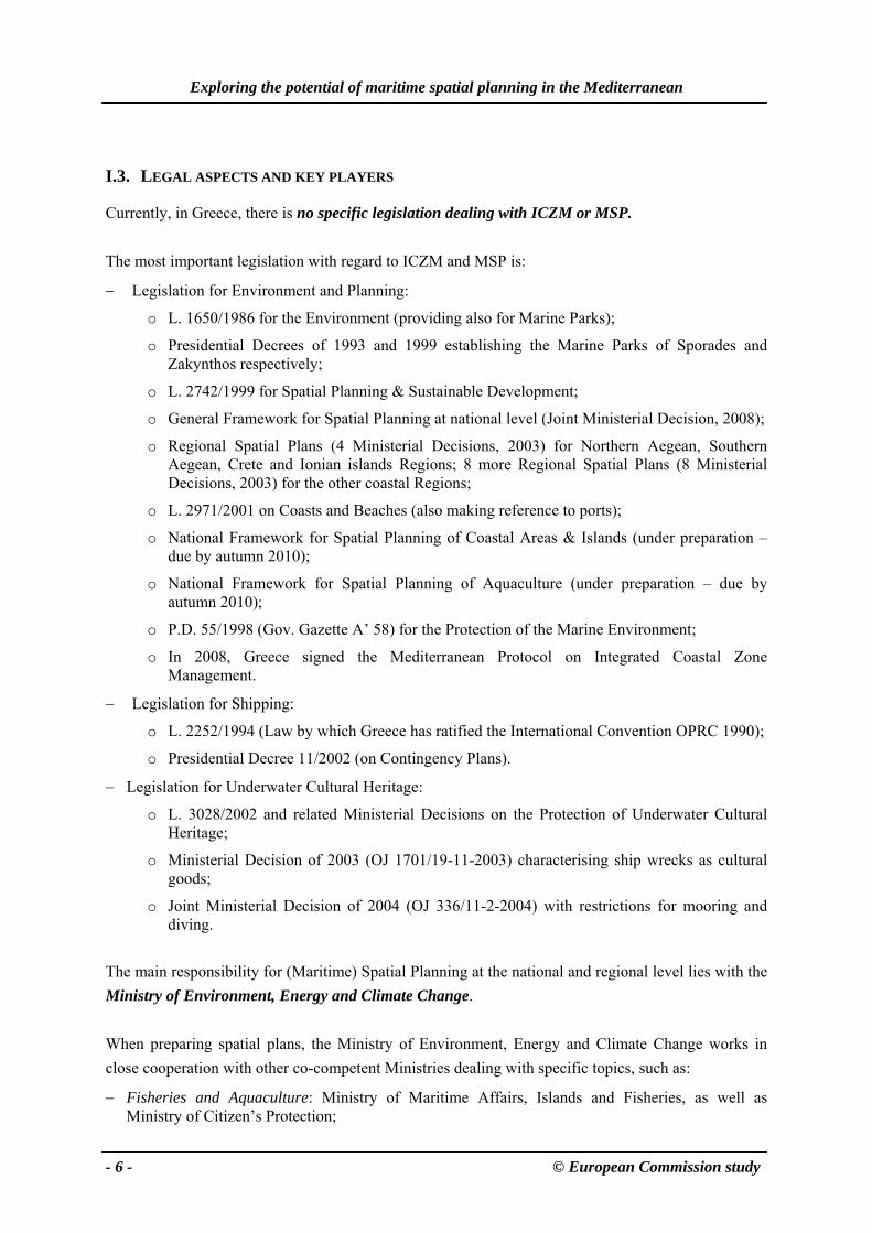
Concerning future activities and the introduction of renewable, offshore energies, the 4C Offshore Global Wind Farms Database11 – a database developed by an independent marine energy consultancy company – indicates three offshore wind farms to be in their early planning or concept phase (not yet submitted for licensing12). These possible wind farms would be located in the Aegean Sea. Figure 2 shows their locations.
Figure 2: Potential offshore wind farms – Greece
Territorial Sea (12nm)
Territorial Sea (12nm)
Territorial Sea (12nm)
Zakros
Avgo
Okeaos
Concept/Early planning
Source: Policy Research Corporation based on 4C Offshore, 2009, Global Offshore Wind Farms Database,
www.4coffshore.com/offshorewind
11 4C Offshore, 2009, Global Offshore Wind Farms Database, www.4coffshore.com/offshorewind. 12 Ministry of Environment, Energy and Climate Change, e-mail April 7, 2010.
Exploring the potential of maritime spatial planning in the Mediterranean
- 6 - © European Commission study
I.3. LEGAL ASPECTS AND KEY PLAYERS
Currently, in Greece, there is no specific legislation dealing with ICZM or MSP. The most important legislation with regard to ICZM and MSP is:
− Legislation for Environment and Planning:
o L. 1650/1986 for the Environment (providing also for Marine Parks);
o Presidential Decrees of 1993 and 1999 establishing the Marine Parks of Sporades and Zakynthos respectively;
o L. 2742/1999 for Spatial Planning & Sustainable Development;
o General Framework for Spatial Planning at national level (Joint Ministerial Decision, 2008);
o Regional Spatial Plans (4 Ministerial Decisions, 2003) for Northern Aegean, Southern Aegean, Crete and Ionian islands Regions; 8 more Regional Spatial Plans (8 Ministerial Decisions, 2003) for the other coastal Regions;
o L. 2971/2001 on Coasts and Beaches (also making reference to ports);
o National Framework for Spatial Planning of Coastal Areas & Islands (under preparation – due by autumn 2010);
o National Framework for Spatial Planning of Aquaculture (under preparation – due by autumn 2010);
o P.D. 55/1998 (Gov. Gazette A’ 58) for the Protection of the Marine Environment;
o In 2008, Greece signed the Mediterranean Protocol on Integrated Coastal Zone Management.
− Legislation for Shipping:
o L. 2252/1994 (Law by which Greece has ratified the International Convention OPRC 1990);
o Presidential Decree 11/2002 (on Contingency Plans).
− Legislation for Underwater Cultural Heritage:
o L. 3028/2002 and related Ministerial Decisions on the Protection of Underwater Cultural Heritage;
o Ministerial Decision of 2003 (OJ 1701/19-11-2003) characterising ship wrecks as cultural goods;
o Joint Ministerial Decision of 2004 (OJ 336/11-2-2004) with restrictions for mooring and diving.
The main responsibility for (Maritime) Spatial Planning at the national and regional level lies with the Ministry of Environment, Energy and Climate Change. When preparing spatial plans, the Ministry of Environment, Energy and Climate Change works in close cooperation with other co-competent Ministries dealing with specific topics, such as:
− Fisheries and Aquaculture: Ministry of Maritime Affairs, Islands and Fisheries, as well as Ministry of Citizen’s Protection;
Country reports
© European Commission study - 7-
− Shipping: Ministry of Maritime Affairs, Islands and Fisheries, Ministry of Citizen’s Protection (on maritime safety and security matters);
− Underwater Cultural Heritage, Tourism: Ministry of Culture and Tourism;
− Maritime Transportation and Ports: Ministry of Maritime Affairs, Islands and Fisheries.
Most of these Ministries are also involved in the licensing process at the implementation stage. Moreover, cooperation is established with scientific institutions (e.g. the National Centre for Marine Research, Universities and the HENCORE network). Spatial plans are accompanied by Strategic Environmental Impact studies and are followed by a public consultation procedure. Regional authorities are responsible for implementation and licensing of smaller installations. Greece has a long tradition in spatial planning. In 1976 the first main law for spatial planning was approved. It was the first time that provisions for spatial plans on a regional and country level and provisions for special areas were made13. Law 2742 (1999) on Spatial Planning and Sustainable Development envisaged the issuing of national level orientations (“Special Frameworks for Spatial Planning and Sustainable Development”) for the development of sectors and/or areas of special interest, such as coastal zones, islands, mountain areas and, generally, areas with persisting environmental, urbanisation and social problems14. In 2002 – 2003 a draft Ministerial Decision was prepared for a “Special Framework of Spatial Planning and Sustainable Development of the Coastal Areas”, which would constitute a national strategy for the entire coastal space including continental and insular parts of Greece. However, the decision to adopt this Framework was not taken at that time; instead, the integration of the objectives related to coastal zone management into different sectoral policies and plans was considered as a more preferable option15. In 2005, the process for the development of the General National Framework of Spatial Planning and three Special Frameworks (for Renewable Energy, Industry and Tourism, also at national scale) began. These frameworks were expected to incorporate and specify the objectives and targets of ICZM. Only after the final approval of these instruments, the possible necessity of an additional individual instrument on ICZM would be further discussed. The objectives of these frameworks were to determine in a fifteen-year plan with the basic priorities and strategic directions for the integrated
13 Ministry of Environment, Energy and Climate Change, e-mail April 7, 2010. 14 Ministry of Environment, Energy and Climate Change, e-mail April 7, 2010. 15 Ministry of Environment, Physical Planning and Public Works, 2006, Report of Greece on Coastal Zone Management,
Athens.

Exploring the potential of maritime spatial planning in the Mediterranean
- 8 - © European Commission study
and sustainable regional development and the sustainable organisation of national space. The plans would provide provisions on maritime issues too (in a sectoral way, as regards the three Special Frameworks). In April 2009, the last of the first three Special Frameworks, namely Tourism (comprehensive spatial plan with orientations for one of the major sectors considered essential for the country’s organised development and the protection of the environment) was approved. This plan would add to the General National Plan and the Special Plans for Renewable Energy Sources and for Industry, which had already passed into law. Furthermore, it was considered that spatial planning of coasts and mountains was important but not fully covered by these first plans and, therefore, the completion of the respective spatial plans should be accelerated. These Special Frameworks would be prepared and presented for consultation in the coming period. Greece’s legislative framework for spatial planning would be completed with one more Special Framework: the one on Aquaculture. The Special Frameworks are relevant to the planning of maritime activities (in a sectoral way) for, among others, the following reasons16:
− The Special Framework Plan for Renewable Energy Sources provides a more concrete regulatory frame for marine wind parks;
− The Special Framework Plan for Tourism defines the conditions for marine and coastal tourism development, which mainly concerns rental boats; proposes the promotion of scuba diving; provides a framework for development of nature tourism in protected areas, including the national marine parks of Zakynthos and N. Sporades.
The necessity of a coordinated Spatial Planning of marine areas in Greece is underlined by its geographical characteristics and its dependence on certain maritime activities. Until recently, Greece’s approach towards spatial planning of maritime activities has been rather sectoral17:
− A holistic approach is still absent;
− The spatial planning of each maritime activity sometimes involves a number of legislative acts and several authorities (mainly at the centralised level);
− Though competences for spatial planning are clear, there is no single authority with an overview of all development activities that are being planned in the marine environment; as a result, there is often overlapping and duplication instead of complementarity;
− Though a legal basis exists, some activities are not being implemented so far in the marine environment of Greece (for instance, up to now there was no real reason to have offshore wind farms or offshore mariculture plants since the needs are covered on land or in the territorial waters respectively).
16 Ministry of Environment, Physical Planning and Public Works (Mourmouris, A.), 2006, Report of Greece on Coastal
Zone Management, Athens. 17 European Commission – DG Maritime Affairs and Fisheries, 2008, Legal aspects of Maritime Spatial Planning:
appendices.

Country reports
© European Commission study - 9-
To conclude, the draft Special Framework for Spatial Planning of Coastal Areas and Islands is the plan that incorporates and specifies in a more concrete way the objectives and strategies of the ICZM, as reflected in the Community Resolution and other related texts as well as in the Mediterranean Protocol on ICZM. In fact, this Framework – which deals both with the terrestrial part and the marine part of the coastal zone (up to the outer limit of the territorial sea) – will include guidance for MSP, will follow an integrated management perspective and an eco-systems approach. The Framework is expected to be completed in autumn 201118. In addition, a Framework for Spatial Planning of Aquaculture (with emphasis on mariculture) is under preparation and is expected to be finalised by the end of 2010. To avoid misinterpretation, it needs to be stressed that, so far, no real need and / or pressure has been experienced in Greece that called for new legislation and application of Maritime Spatial Planning. It is likely that pressure or competition of uses will be experienced in the future in some of the most “crowded” gulfs of the country, as well as when installing offshore wind farms or offshore mariculture units. Even though Maritime Spatial Planning is considered as a useful instrument to resolve competition in such cases, it is believed to be less appropriate and rather costly to apply MSP to the entire country, given the considerable length of its coastline and the monitoring mechanism required to this end19. Furthermore, no significant cross-border / international competition is experienced, contrary to other Community or Mediterranean countries that have already proceeded to cooperation schemes for MSP20.
I.4. NATIONAL AND SUB-NATIONAL PLANS, PROJECTS AND STUDIES RELATED TO ICZM AND MSP
Greece’s interest in Integrated Coastal Zone Management was expressed on many occasions21. The country developed, among others, a Coastal Area Management Programme (CAMP) for the Island of Rhodes and a number of ICZM-related projects. Table 4 provides more details on CAMP Rhodes while more information on the ICZM-related projects in Greece can be found in Table 5. Furthermore, Greece signed the Barcelona Convention’s Protocol on Integrated Coastal Zone Management in 2008 (see Annex II of the final report).
18 Source: Greek authorities. 19 Ministry of Environment, Energy and Climate Change, e-mail February 22, 2010. 20 Ministry of Environment, Energy and Climate Change, e-mail February 22, 2010; Ministry of Environment, Energy and
Climate Change, e-mail April 7, 2010. 21 Ministry of the Environment, Physical Planning and Public Works, 2006, Report of Greece on Coastal Zone
Management, Athens.

Exploring the potential of maritime spatial planning in the Mediterranean
- 10 - © European Commission study
Table 4: Coastal Area Management Programme – The Island of Rhodes
• Implementation of the LBS (Land-Based Sources) and Dumping Protocol• Pollution monitoring and control• Liquid waste management• Renewable energies• Geographical Information System (GIS), Environmental Impact Assessment (EIA) and carrying capacity
for tourism• Integrated planning• Protection of natural resources• Protection of cultural heritage
1991 – 1996Timeframe:
700 000 USD provided by METAP, European Investment Bank and UNEP-MAPProject funding:
• Basic policy recommendations: (1) to reduce the planned expansion of tourism facilities, (2) to implement measures recommended for a gradual establishment of a diversified economy and (3) to implement major detailed plans
• Training on water resource management master plan, GIS and EIA• Supply of equipment and software
Results:
The project was implemented in three phases, as Priority Action Programme pilot project, as CAMP project and as METAP-EIB/MAP project funded by the EIB. Owing to the funds secured by EIB, the last phase dealt with in-depth planning, including preparation of feasibility studies, master plans and detailed integrated plans; the following activities were implemented during these three phases:
Objectives:
Located in the South-Eastern Aegean Sea, Rhodes is the largest island and the most important tourist resort of the Dodecanese Archipelago; the island covers a surface area of 1 394 km² and its coastline is 220 km long
Area covered:
Source: Policy Research Corporation based on PAP/RAC, the Mediterranean ICAM Clearing House,
www.pap-medclearinghouse.org/eng/about_ch.asp; PAP/RAC, The Coastal Management Centre, www.pap-thecoastcentre.org
Table 5: ICZM-related projects – Greece
Name Project Funding Timeframe Concerted Actions for the Management of the Strymonikos Coastal Zone
TERRA22 1997 – 2000
Programme for Integrated Coastal Zone Management. The case of Cyclades-Archipelago
LIFE23 1997 – 2000
Territorial Co-ordination Scheme for the Harbour System and Coast of Athens – “Posidonia Network”
TERRA 1997 – 2000
Information, Concertation, Requirements for the Sustainable Development of Magnesia’s Coastal Zone
LIFE 1997 – 2000
Integrated Management of the Coast of Epiros TERRA 1997 – 2001 Integrated Coastal Zone Management for the Kavala Prefecture TERRA 1998 – 2001 Strategies for Management and Co-operation in the Metropolitan and Peri-urban Coastal Zones of the Saronic Gulf – Athens
TERRA NA
Source: Policy Research Corporation based on PAP/RAC, the Mediterranean ICAM Clearing House, www.pap-medclearinghouse.org/eng/about_ch.asp
22 TERRA was launched in 1997 in the context of the innovative actions financed by the Art. 10 of the ERDF regulation;
TERRA was conceived as a laboratory for testing new approaches to and methodologies for spatial planning. 23 LIFE is the EU’s financial instrument supporting environmental and nature conservation projects throughout the EU, as
well as in some candidate, acceding and neighbouring countries.

Country reports
© European Commission study - 11-
In addition, a number of projects related to the development of islands (e.g. in Cyclades) have been financed in the past by ENVIREG24. Currently, Greece participates in the EC project on Spatial Cohesion of European Islands. Furthermore, a database containing maps of more than 2 000 ship wrecks and 130 underwater archaeological sites was established as well as National Contingency Plans which are issued to respond to oil pollution and other harmful incidents25. Moreover, there are Regional Spatial Plans in place for four Insular administrative Regions: Northern Aegean, Southern Aegean, Crete and Ionian, which cover the land part but also provide for some marine activities. Similar Regional Spatial Plans exist for eight more coastal regions. There is a clear intention of the Ministry of Environment, Energy and Climate Change (accompanied by allocation of the necessary funding) to review and update all these Regional Spatial Plans dating from 2003 on the basis of evaluation of their implementation so far, as well as of the orientations of the more recent Frameworks for Spatial Planning26.
I.5. STATUS OF THE IMPLEMENTATION OF THE MARINE STRATEGY FRAMEWORK DIRECTIVE
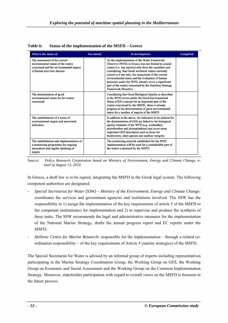
Table 6 provides insight into the current status of the implementation of the Marine Strategy Framework Directive (MSFD) in Greece.
24 The ENVIREG Programme was one of the Community Initiatives related to the Structural Funds during the 1989 – 1993
period. 25 Ministry of Environment, Energy and Climate Change, e-mail February 22, 2010; Ministry of Environment, Energy and
Climate Change, e-mail April 7, 2010. 26 Ministry of Environment, Energy and Climate Change, e-mail April 7, 2010.
Exploring the potential of maritime spatial planning in the Mediterranean
- 12 - © European Commission study
Table 6: Status of the implementation of the MSFD – Greece
The monitoring network established for the WFD implementation will be used for a considerable part of the waters concerned by the MSFD
The establishment and implementation of a monitoring programme for ongoing assessment and regular updating of targets
In addition to the above, the indicators to be utilised for the determination of GES are linked to the biological quality elements of the WFD (e.g. zoobenthos, phytobenthos and phytoplankton) and cover some important GES descriptors such as those for biodiversity, alien species and seafloor integrity
The establishment of a series of environmental targets and associated indicators
Considering that Good Biological Quality as described in the WFD covers partly the Good Environmental Status (GES) concept for an important part of the waters concerned by the MSFD, there is already progress in the determination of good environmental status for a number of aspects of the MSFD
The determination of good environmental status for the waters concerned
As the implementation of the Water Framework Directive (WFD) in Greece was not limited to coastal waters (i.e. one nautical mile from the coastline) and considering that Greek territorial waters currently extend to 6 nm only, the assessment of the current environmental status and the evaluation of human pressures under the WFD, already cover a significant part of the waters concerned by the Maritime Strategy Framework Directive
The assessment of the current environmental status of the waters concerned and the environmental impact of human activities thereon
CompletedIn developmentNot startedWhat is the status of:
Source: Policy Research Corporation based on Ministry of Environment, Energy and Climate Change, e-
mail of August 13, 2010
In Greece, a draft law is to be signed, integrating the MSFD in the Greek legal system. The following competent authorities are designated:
- Special Secretariat for Water (SSW) – Ministry of the Environment, Energy and Climate Change: coordinates the services and government agencies and institutions involved. The SSW has the responsibility to 1) assign the implementation of the key requirements of article 5 of the MSFD to the competent institution(s) for implementation and 2) to supervise and produce the synthesis of these tasks. The SSW recommends the legal and administrative measures for the implementation of the National Marine Strategy, drafts the annual progress report and EC reports under the MSFD;
- Hellenic Centre for Marine Research: responsible for the implementation – through a related co-ordination responsibility – of the key requirements of Article 5 (marine strategies) of the MSFD.
The Special Secretariat for Water is advised by an informal group of experts including representatives participating in the Marine Strategy Coordination Group, the Working Group on GES, the Working Group on Economic and Social Assessment and the Working Group on the Common Implementation Strategy. Moreover, stakeholder participation with regard to overall views on the MSFD is foreseen in the future process.
Country reports
© European Commission study - 13-
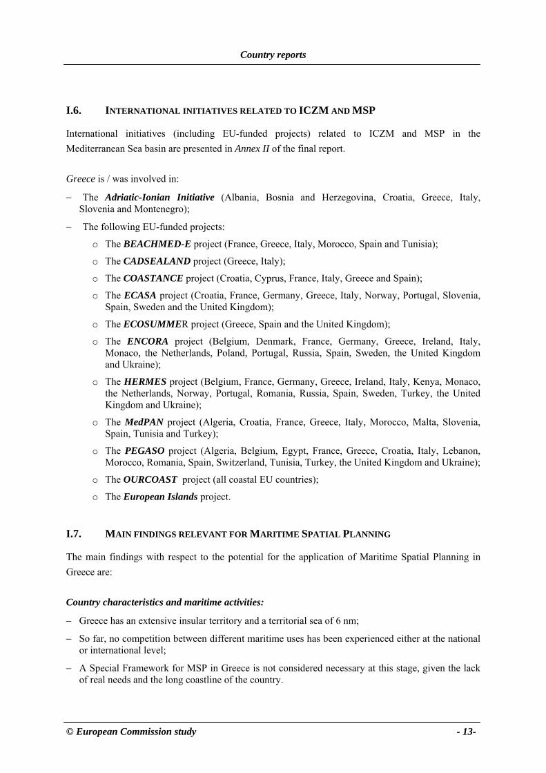
I.6. INTERNATIONAL INITIATIVES RELATED TO ICZM AND MSP
International initiatives (including EU-funded projects) related to ICZM and MSP in the Mediterranean Sea basin are presented in Annex II of the final report. Greece is / was involved in:
− The Adriatic-Ionian Initiative (Albania, Bosnia and Herzegovina, Croatia, Greece, Italy, Slovenia and Montenegro);
− The following EU-funded projects:
o The BEACHMED-E project (France, Greece, Italy, Morocco, Spain and Tunisia);
o The CADSEALAND project (Greece, Italy);
o The COASTANCE project (Croatia, Cyprus, France, Italy, Greece and Spain);
o The ECASA project (Croatia, France, Germany, Greece, Italy, Norway, Portugal, Slovenia, Spain, Sweden and the United Kingdom);
o The ECOSUMMER project (Greece, Spain and the United Kingdom);
o The ENCORA project (Belgium, Denmark, France, Germany, Greece, Ireland, Italy, Monaco, the Netherlands, Poland, Portugal, Russia, Spain, Sweden, the United Kingdom and Ukraine);
o The HERMES project (Belgium, France, Germany, Greece, Ireland, Italy, Kenya, Monaco, the Netherlands, Norway, Portugal, Romania, Russia, Spain, Sweden, Turkey, the United Kingdom and Ukraine);
o The MedPAN project (Algeria, Croatia, France, Greece, Italy, Morocco, Malta, Slovenia, Spain, Tunisia and Turkey);
o The PEGASO project (Algeria, Belgium, Egypt, France, Greece, Croatia, Italy, Lebanon, Morocco, Romania, Spain, Switzerland, Tunisia, Turkey, the United Kingdom and Ukraine);
o The OURCOAST project (all coastal EU countries);
o The European Islands project.
I.7. MAIN FINDINGS RELEVANT FOR MARITIME SPATIAL PLANNING
The main findings with respect to the potential for the application of Maritime Spatial Planning in Greece are: Country characteristics and maritime activities:
− Greece has an extensive insular territory and a territorial sea of 6 nm;
− So far, no competition between different maritime uses has been experienced either at the national or international level;
− A Special Framework for MSP in Greece is not considered necessary at this stage, given the lack of real needs and the long coastline of the country.

Exploring the potential of maritime spatial planning in the Mediterranean
- 14 - © European Commission study
Current status Integrated Coastal Zone Management / Maritime Spatial Planning:
− Several ICZM-related projects were conducted in Greece;
− Although currently no competition between maritime uses is experienced and consequently no MSP is applied in practice, Greek authorities believe competition to be likely to occur in the future; in this case, MSP is considered to be a useful tool to address specific areas experiencing competition;
− The Framework for Spatial Planning of the Coastal Areas and Islands – which deals both with the terrestrial part and the marine part (up to the outer limit of the territorial sea) of the coastal zone – will include guidance for MSP, will follow an integrated management perspective and an eco-systems approach. The Framework is expected to be completed by autumn 2011;
− A Framework for Spatial Planning of Aquaculture (with emphasis on Mariculture) is under preparation and is expected to be finalised by the end of 2010.
International cooperation:
− Greece is an active Contracting Party of the Barcelona Convention and its annexed Protocols for the protection of the Mediterranean environment; the headquarters of the Mediterranean Action Plan (MAP/UNEP) are in Athens and multilateral cooperation in the region continues since 1975;
− Greece has signed the Protocol concerning Special Protected Areas and Biodiversity in the Mediterranean (1995) as well as the Mediterranean Protocol on ICZM (2008) that refers among others to MSP and participates in activities to promote/facilitate its implementation;
− Greece is involved in the Adriatic-Ionian Initiative, resulting in good relationships with the Adriatic countries;
− Cross-border / international MSP will probably prove to be difficult with Turkey;
− There are bilateral agreements of Greece with Italy and Turkey concerning cooperation on protection of the environment.
− Greece has ratified, by Law 3497/2006 (Gov. Gazette A’ 219), the Protocol concerning Co-operation in Prevention Pollution from ships and, in cases of emergency, combating pollution in the Mediterranean Sea (the 2002 Prevention and Emergency Covering Protocol). Since 27/12/2006, the above Law, which supports the promotion and development of sub-regional Contingency Plans and other means necessary for the combating of marine pollution incident and for the protection of the marine environment of the Mediterranean Sea has been entered into force covering the Mediterranean Sea as a whole.

Country reports
© European Commission study - 15-
I.8. OVERVIEW OF SOURCES OF INFORMATION USED AND PERSONS CONTACTED
Sources of information used:
− ANA-MPA, 2009, Inner cabinet approves spatial plan for tourism, ANA MPA Daily News Bulletin (Thursday 30 April 2009, Issue No: 3182);
− Baltas, E., Spatial Planning and regional development of Greece;
− Britannica Online Encyclopaedia, www.britannica.com;
− EarthTrends, Coastal and Marine Ecosystems – searchable database;
− Edison S.p.A., Public Gas Corporation of Greece S.A., Poseidon Pipeline Open Season Notice;
− European Commission, 2008, 2008 Environment Policy Review;
− European Commission – DG Maritime Affairs and Fisheries, EU Maritime Policy: Facts and Figures – Greece;
− European Commission – DG Maritime Affairs and Fisheries, 2008, Legal aspects of Maritime Spatial Planning: appendices;
− European Commission – DG Environment, Evaluation of Integrated Coastal Zone Management (ICZM) in Europe – Greece, http://ec.europa.eu/environment/iczm/evaluation/iczm_national_reporting_greece.htm;
− European Commission – DG Environment, 2009, NATURA 2000 area calculation;
− European Sea Ports Organisation, www.espo.be;
− FAO, Yearbook of fishery statistics;
− Ministry of the Environment, Physical Planning and Public Works (Mourmouris A.), 2006, Report of Greece on Coastal Zone Management, Athens;
− Ministry of the Environment, Physical Planning and Public Works, www.minenv.gr;
− MRAG, 2008, Legal aspects of Maritime Spatial Planning;
− PAP/RAC, 2001, White Paper: Coastal Zone Management in the Mediterranean, Split;
− PAP/RAC, The Coastal Management Centre, www.pap-thecoastcentre.org;
− PAP/RAC, the Mediterranean ICAM Clearing House, www.pap-medclearinghouse.org/eng/about_ch.asp;
− Safemed Project maritime traffic flows and risks analysis in the Mediterranean Sea, www.safemedgis.org;
− The Network of Managers of Marine Protected Areas in the Mediterranean, www.medpan.org;
− UNEP/MAP, 2004, Mariculture in the Mediterranean, Athens;
− 4C Offshore, 2009, Global Offshore Wind Farms Database, www.4coffshore.com/offshorewind.
Exploring the potential of maritime spatial planning in the Mediterranean
- 16 - © European Commission study
Persons contacted:
− Dr Anastasia Strati, Ministry of Foreign Affairs; Expert Counsellor, Law of the Sea
− Dr Athena Mourmouris, Ministry of the Environment, Energy and Climate Change; Environmental Engineer & Planner. Provided information and gathered information from the following ministries:
o the Ministry of Culture and Tourism;
o the Ministry ofMaritime Affairs, Islands and Fisheries;
o the Ministry of Citizen’s Protection;
− Ms. Elpida Politi, Ministry of the Environment, Energy and Climate Change;
− Ms. Katerina Kanellopoulou, Ministry of the Environment, Energy and Climate Change.