Great Walks Milford Track - plan and prepare - doc.govt.nz · (Milf or dS un ) Sutherland Fa ls M...
6
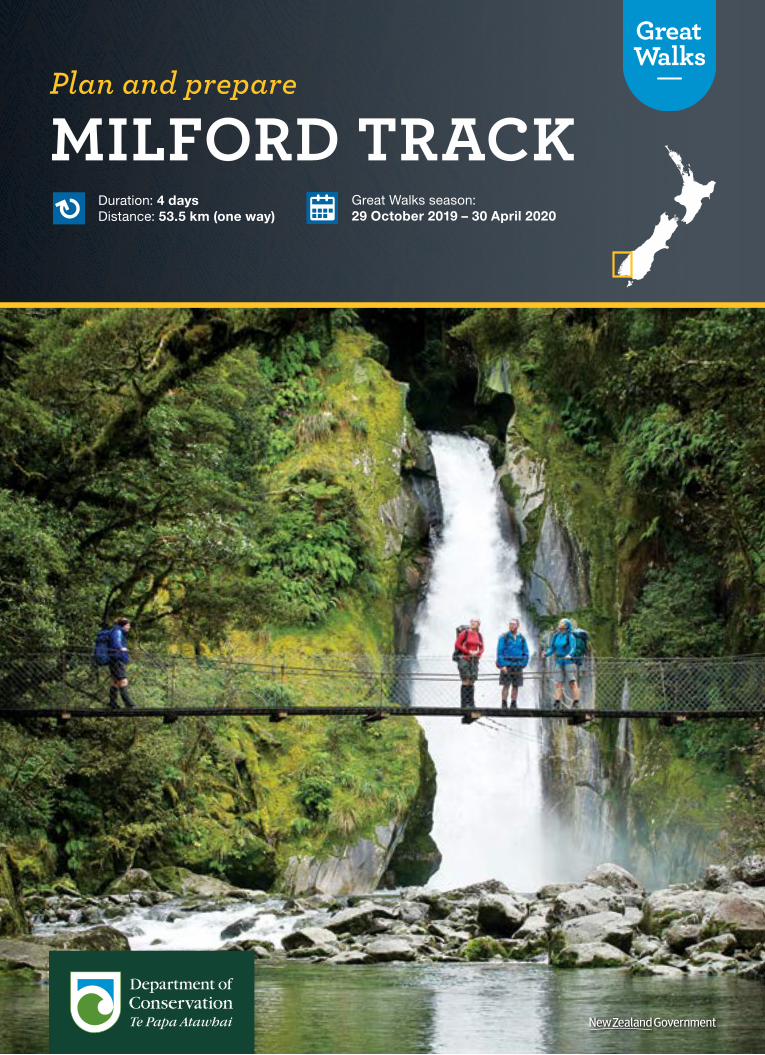
Duration: 4 days Distance: 53.5 km (one way) Great Walks season: 29 October 2019 – 30 April 2020 MILFORD TRACK Plan and prepare
Transcript of Great Walks Milford Track - plan and prepare - doc.govt.nz · (Milf or dS un ) Sutherland Fa ls M...
Great Walks season: 23 October 2018 – 30 April 2019
Duration: 4 days Distance: 53.5 km (one way)Duration: 4 days Distance: 53.5 km (one way)
Great Walks season: 29 October 2019 – 30 April 2020
MILFORD TRACKPlan and prepare
Duration: 4 days Distance: 53.5 km (one way)
Great Walks season: 29 October 2019 – 30 April 2020
MILFORD TRACKExperience the ‘finest walk in the world’ as you retrace the steps of early explorers on the world-renowned Milford Track.
Take a journey along valleys carved by glaciers, wander through ancient rainforests and admire cascading waterfalls. You’ll follow a historic route through Fiordland National Park, part of Te Wāhipounamu – South West New Zealand World Heritage Area, before reaching your final destination, the spectacular Milford Sound/Piopiotahi.
The Milford Track can only be walked in one direction. The track is well marked and signposted, but some sections are steep and rough and the track may be muddy and slippery. Poor weather conditions can make this walk challenging, even in the Great Walks season.
This brochure describes a 4-day hike for independent, non-guided walkers from the head of Lake Te Anau to Sandfly Point in Milford Sound/Piopiotahi during the Great Walks season (29 October 2019 – 30 April 2020).
1000 m
750 m
500 m
250 m
0 m
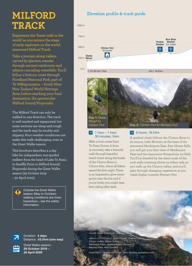
Day 1: Glade Wharf to Clinton Hut
1 hour – 1 hour 30 minutes, 5 km
After a boat cruise from Te Anau Downs (1 hour 15 minutes), take a leisurely walk through beautiful beech forest along the banks of the Clinton River to Clinton Hut, where all hikers spend the first night. There is an impressive glow-worm grotto near the hut and if you’re lucky, you might hear kiwi calling after dark.
Day 2: Clinton Hut to Mintaro Hut
6 hours, 16.5 km
A gradual climb follows the Clinton River to its source, Lake Mintaro, at the base of the renowned Mackinnon Pass. Past Hirere Falls you will get your first view of Mackinnon Pass and the impressive Pompolona ice field. You’ll be dwarfed by the sheer scale of the rock walls towering above on either side as you walk up the Clinton valley, and you’ll pass through changing vegetation as you climb higher towards Mintaro Hut.
Clinton Hut40 bunks
Prairie Shelter
Bus Stop Shelter
(no toilet)
Glade Wharf
Elevation profile & track guide
6 hr / 16.5 km1 –1 hr 30 min / 5 km
Outside the Great Walks season (May to October) walking conditions are more hazardous – see the safety information.
COVER: Giant Gate Falls, Graham Dainty
ABOVE LEFT TO RIGHT: Beech forest, Graham Dainty; Clinton Valley, Daniel Deans; Makinnon Pass, stokedforsaturday.com; Mackay Falls, Rob Suisted
MAIN PHOTO: Mackinnon Pass, John Strother (panafoot.com)
hut toiletshelter and toilet
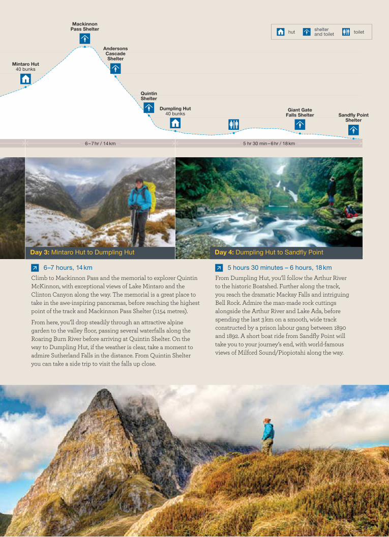
Day 3: Mintaro Hut to Dumpling Hut
6–7 hours, 14 km
Climb to Mackinnon Pass and the memorial to explorer Quintin McKinnon, with exceptional views of Lake Mintaro and the Clinton Canyon along the way. The memorial is a great place to take in the awe-inspiring panoramas, before reaching the highest point of the track and Mackinnon Pass Shelter (1154 metres).
From here, you’ll drop steadily through an attractive alpine garden to the valley floor, passing several waterfalls along the Roaring Burn River before arriving at Quintin Shelter. On the way to Dumpling Hut, if the weather is clear, take a moment to admire Sutherland Falls in the distance. From Quintin Shelter you can take a side trip to visit the falls up close.
5 hours 30 minutes – 6 hours, 18 km
From Dumpling Hut, you’ll follow the Arthur River to the historic Boatshed. Further along the track, you reach the dramatic Mackay Falls and intriguing Bell Rock. Admire the man-made rock cuttings alongside the Arthur River and Lake Ada, before spending the last 3 km on a smooth, wide track constructed by a prison labour gang between 1890 and 1892. A short boat ride from Sandfly Point will take you to your journey’s end, with world-famous views of Milford Sound/Piopiotahi along the way.
Day 4: Dumpling Hut to Sandfly Point
Sandfly Point Shelter
Mintaro Hut40 bunks
Dumpling Hut40 bunks
Mackinnon Pass Shelter
Andersons Cascade Shelter
Quintin Shelter
Giant Gate Falls Shelter
5 hr 30 min – 6 hr / 18 km6 – 7 hr / 14 km

Photo: John Strother (panafoot.com)
Photo: Sabine Bernert
Photo: John Strother (panafoot.com) Photo: Shellie Evans
Photo: Keri Moyle (signsoflife.co.nz)
Highlights
2
1
43
5
Conservation story1 Keep an eye out for the rare blue duck/whio.
Once widespread around New Zealand, the introduction of predators drastically reduced their numbers and they are now only found in a few locations. Predator control programmes supported by Air New Zealand and Genesis have doubled the number of stoat traps and increased possum and rat control over an extra 8500 hectares around the Milford Track. This has allowed whio to return to the area, along with other native birds.
2 Take your camera to capture the stunning panoramas from Mackinnon Pass across ancient valleys carved by glaciers.
3 Fiordland’s many streams, rivers and waterfalls are especially spectacular after rainfall. Take a side trip from Quintin Shelter to see Sutherland Falls, which drop 580 metres (1904 feet) from Lake Quill.
4 In the alpine section of the Milford Track you will be in for a special treat between November and February. Flowering plants such as the Mount Cook buttercup, mountain daisy and the dainty gentian almost steal the show from the expansive vistas.
5 Enjoy the emerald waters of the Clinton River. Even when it is metres deep, the crystal-clear water allows you to see every stone on the bottom and admire trout or native longfin eel/tuna cruising the deep pools.
Air New Zealand partners with the
Department of Conservation to help
bring native birds back to the beautiful
Great Walks.

Photo: Keri Moyle (signsoflife.co.nz)
HomerTunnel
LakeQuill
(no toilet)
Mackinnon Pass Shelter
Clinton Hut
Prarie Shelter
Bus Stop Shelter
Mintaro Hut
Andersons Cascade Shelter
Quintin Shelter
DumplingHut
Giant GateFalls Shelter
Sandfly Point Shelter
CampO
venC
reek
Arthur Rive
r
Diam
ondC
reek
Poseidon
Creek
Joe s River
Cleddau River
Sl ip Creek
Talbot River
Mackay
Creek
Nea
leB
urn
SurpriseCreek
Clinton River
Castle River
Term
inu
sC
reek
McQ
uee n
Cre
ek.
Worsley Sream
Prospect
Creek
Milford Sound/ Piopiotahi
Sutherland Falls
MackayFalls
W I C K M O U N T A I N S
SH
E
E R D O W NH I L L S
9494
ToTe
Anau
Fiordland National Park
Glade Wharf
Lake Te Anau
"
"
"
"
"
"
"
"
"
"
"
"
"
"
"
"
Barrier Peak
Couloir Peak
Castle Mount
Mount Balloon
Mount Elliot
Mount Wilmur
Mount Mitchelson
Mount Anau
Mount Park
Mount Gendarme
Dumpling Hill
Lady of the Snows
Mount Danger
Mount KepkaLloyd Peak
Mount Ada
Access Peak
Terror Peak
Odyssey Peak
Devils Armchair
Mount McPherson
Sheerdown Peak
Llawrenny Peaks Barren Peak
1729m
1956m
1713m
1729m
1774m
2122m
1800m
1982m
1869m1720m
1730m
1878m
1821m
1865m
1881m
1931m
1931m
1962m
1936m
1891m
1749m
1925m
1944m
1767m
1786m
1825m
1818m
1781m
1990m
1710m
1782m
1876m
1
2
3
4
56
7
8
9
10
11
12
13
141516
17
181920
21
22
23
24
25
26
27
28
29
30
31
32
33
Lake
Ada
LakeBrown
" Great Walk hut
" Shelter and toilet
" Toilet
Mile marker
Great Walk
Tramping track
Boat transport
State Highway
Other roads
0 1 Km ¯
CHRISTCHURCH
BLENHEIM
Picton
Kaikoura
Hanmer Springs
St Arnaud
Reefton
Westport
Punakaiki
Franz Josef/Waiau
Haast
Greymouth
Kumara
Hokitika
Karamea
Oxford Rangiora
Kaiapoi
Akaroa
Methven
Kurow Waimate
Temuka
Milton
Kaka Point
Balclutha
Fairfield
QUEENSTOWN
Twizel
Aoraki/Mount Cook
Makaroa
Wanaka
ASHBURTON
GeraldineFairlie
TIMARU
OAMARU
Waikouaiti
Palmerston
Cromwell
Clyde
Alexandra
Ranfurly
DUNEDIN
Milford Sound
Arrowtown
Glenorchy
Stewart Island/Rakiura
Oban
TE ANAU
Mataura
Riverton/Aparima
Winton
Dipton
LumsdenMossburn
GORE
INVERCARGILL
Takaka
Motueka
Wakefield
NELSON
Murchison
ABEL TASMAN COAST TRACK
HEAPHY TRACK
ROUTEBURN TRACK
KEPLER TRACK
RAKIURA TRACK
MILFORD TRACK
Aoraki/Mt Cook National Park Visitor Centre
Westland Tai Poutini National Park Visitor Centre
Awarua/Haast Visitor Centre
Arthur’s Pass National Park Visitor Centre
Rotoiti/Nelson Lakes Visitor Centre
Nelson Visitor Centre
Paparoa National Park Visitor Centre
Ōtautahi/Christchurch Visitor Centre
Tititea/Mount AspiringNational Park Visitor Centre
Whakatipu-wai-Māori/Queenstown Visitor Centre
Ōtepoti/Dunedin Visitor Centre
Rakiura National ParkVisitor Centre
Te Rua-o-te-moko/Fiordland National Park Visitor Centre
The Milford Track is accessed by boat from Te Anau Downs, 27 km from Te Anau on SH94.
The track starts at Glade Wharf at the head of Lake Te Anau. Take a bus or private transport to Te Anau Downs (30 minutes), then a boat trip to the head of Lake Te Anau (1 hour 15 minutes).
The track finishes at Sandfly Point. Take a boat trip (20 minutes) to Milford Sound/Piopiotahi, where there are bus services back to Te Anau and on to Queenstown.
During the Great Walks season (29 October 2019 – 30 April 2020), there are regular transport services to and from the track, which must be booked in advance – you can use the link in your hut booking confirmation to book your transport.
Getting there
0 25 50 km
DOC operates 3 huts on the Milford Track. These must be booked well in advance during the Great Walks season (29 October 2019 – 30 April 2020) to avoid disappointment. Camping is not permitted on the Milford Track.
As a tribute to the long
history of the Milford Track, distances are often still referred to in miles rather than kilometres. Markers positioned every mile are a handy reference to track your progress.
33
Milford Track Great Walk hutsNew Zealand rate $70 per adult per night; 17 years and under free (booking required). International rate $140 per person per night for all ages (booking required).
During the Great Walks season the huts have bunks, mattresses, heating, toilets, basic cooking facilities, solar-powered lighting and cold running water. A DOC ranger is in residence. The huts do not provide cooking utensils or showers.
Outside the Great Walks season facilities are greatly reduced and there are no DOC rangers. Booking is not required, huts are first come, first served and fees are reduced. See the DOC website for details.
Places to stay
The map in this brochure is a guide only and should not be used for navigational purposes.
Published by: Department of Conservation, Marketing Team PO Box 10420, Wellington 6143, New Zealand
September 2019
Editing and design: Creative Services, DOC National Office
* Prices are accurate at the time of publication.
This publication is produced using paper sourced from well-managed, renewable and legally logged forests.R
1608
27
Know before you go
It is important to plan your trip thoroughly to make sure you stay safe. Before you go, know the Outdoor Safety Code – 5 simple rules to help you #MakeItHomeNZ.
1. Plan your trip. Choose a trip that fits your abilities. Make sure you have enough time to do your walk, plus extra time. Book accommodation, transport and transfers to the start/end of the track early.
2. Tell someone your plans. Tell someone where you are going and when you’ll be back. Ask them to call emergency services if you haven’t returned on time. Consider carrying a personal locator beacon, as there is no cellphone reception on most tracks.
3. Be aware of the weather. New Zealand weather is very changeable. Even if it’s summer or the forecast is good,
you should always carry a rain jacket and warm clothing. Check metservice.com for the most up-to-date forecast.
4. Know your limits. A good level of fitness is needed to walk the track. Read about the track carefully to make sure it suits your abilities. Always follow the track markers and signposted tracks – going off-track can be hazardous, even for experienced walkers. Don’t be afraid to turn back.
5. Take sufficient supplies. Take the right gear, including extra food, clothing and equipment in case something goes wrong. You’ll have to carry everything you need, as you can’t buy food or equipment at Great Walks huts or campsites.
You can find more information on safety at www.doc.govt.nz/safety or www.adventuresmart.nz.
Safety on the Milford Track
Great Walks season: 29 October 2019 – 30 April 2020
This track is not recommended for children under the age of 10, due to the exposed mountain environment and weather that can change very quickly.
Fiordland National Park lies in an area with high rainfall and changeable weather. Cold temperatures, snow, strong winds and heavy rain can occur at any time of the year. Be prepared for all conditions.
The Milford Track is complex avalanche terrain and the risk of avalanche can extend into December. During the Great Walks season, DOC manages this risk to a low level. Walkers may be flown (at their cost) over dangerous sections.
Parts of the Milford Track are exposed, steep, slippery, rough and muddy. On the third day you will climb over 500 m to Mackinnon Pass and then descend 1000 m to Dumpling Hut. On the fourth day you must walk 18 km, reaching Sandfly Point in time to meet the early afternoon boat. The track will not be suitable for all walkers.
Go to greatwalks.co.nz/milford ‘Know before you go’ section for detailed safety information, and ‘What to take’ section for a full gear list.
Remember – your safety is your responsibility
What do I do next?Start off at greatwalks.co.nz/milford for more information.
Book your huts online at bookings.doc.govt.nz.
Book your transport to and from the track.
Buy your food and pack your bags – download the Great Walks packing list and make sure you have everything you need for a 4-day independent unguided walk.
Read up on safety and make sure you’re well prepared for your journey and changeable weather at greatwalks.co.nz/milford.
Visit the closest DOC Visitor Centre (Te Anau) to pick up your tickets and official track guide, and chat with the friendly staff for the latest weather forecast and track conditions.
All set! Lace up your boots and get hiking. Don’t forget to share your experience on facebook.com/GreatWalks.
You are strongly recommended NOT to attempt this track between early May and late October (outside the Great Walks season).
The winter environment in Fiordland is very cold and wet, with ice, snow, avalanches and short daylight hours.
DOC is unable to manage any hazards outside the Great Walks season. Bridges are removed, as floods and avalanches occur on these tracks during winter.
To attempt the track in winter conditions, you need to be very experienced in backcountry winter navigation, have river crossing expertise and appropriate alpine skills and equipment. Hut facilities are greatly reduced – with no cooking gas, limited water and no hut wardens or emergency hut radios.
For more information, see ‘Outside the Great Walks season’ at greatwalks.co.nz/milford.
For in-depth local knowledge, visit: Fiordland National Park
Visitor Centre Phone: +64 3 249 7924
Email: greatwalksbooking @doc.govt.nz
greatwalks.co.nz