Great Sandy Strait Biopassage Remediation Project Final Report
39
Great Sandy Strait Biopassage Remediation Project – Final Report REDUCING THREATS TO THE GREAT SANDY STRAIT RAMSAR WETLAND & COASTAL SYSTEMS A. P. Berghuis November 2012 Report to the Burnett Mary Regional Group for Natural Resource Management
Transcript of Great Sandy Strait Biopassage Remediation Project Final Report
Great Sandy Strait Biopassage Remediation Project – Final Report REDUCING THREATS TO THE GREAT SANDY STRAIT RAMSAR
WETLAND & COASTAL SYSTEMS
A. P. Berghuis
November 2012
Report to the Burnett Mary Regional Group for Natural Resource Management

This publication has been compiled by Andrew Berghuis of Fisheries Queensland, Department of Agriculture
Fisheries & Forestry under contract to the Burnett Mary Regional Group for Natural Resource Management
© State of Queensland, 2012.
The Queensland Government supports and encourages the dissemination and exchange of its information. The
copyright in this publication is licensed under a Creative Commons Attribution 3.0 Australia (CC BY) licence.
Under this licence you are free, without having to seek our permission, to use this publication in accordance with the
licence terms.
You must keep intact the copyright notice and attribute the State of Queensland as the source of the publication.
For more information on this licence, visit http://creativecommons.org/licenses/by/3.0/au/deed.en
Great Sandy Strait Biopassage Remediation Project – Final Report November 2012 - 3 -
Contents
Contents ......................................................................................................... 3
1.0 Executive Summary .................................................................................. 4
2.0 Introduction ............................................................................................... 6
2.1 Study site .................................................................................................. 6
3.0 Selection of Biopassage sites ................................................................... 7
4.0 Aquatic fauna surveys ........................................................................... 9
4.1 Water quality ........................................................................................... 15
5.0 Case studies for sites selected for Biopassage remediation ................... 16
6.0 Future Biopassage Remediation ............................................................. 35
7.0 Additional project activities ..................................................................... 37
8.0 References ............................................................................................. 38
Great Sandy Strait Biopassage Remediation Project – Final Report November 2012 - 4 -
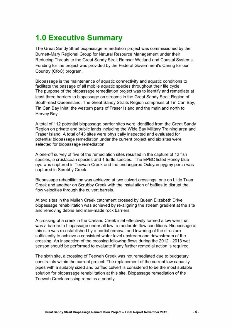
1.0 Executive Summary
The Great Sandy Strait biopassage remediation project was commissioned by the
Burnett-Mary Regional Group for Natural Resource Management under their
Reducing Threats to the Great Sandy Strait Ramsar Wetland and Coastal Systems.
Funding for the project was provided by the Federal Government’s Caring for our
Country (CfoC) program.
Biopassage is the maintenance of aquatic connectivity and aquatic conditions to facilitate the passage of all mobile aquatic species throughout their life cycle. The purpose of the biopassage remediation project was to identify and remediate at
least three barriers to biopassage on streams in the Great Sandy Strait Region of
South-east Queensland. The Great Sandy Straits Region comprises of Tin Can Bay,
Tin Can Bay Inlet, the western parts of Fraser Island and the mainland north to
Hervey Bay.
A total of 112 potential biopassage barrier sites were identified from the Great Sandy
Region on private and public lands including the Wide Bay Military Training area and
Fraser Island. A total of 43 sites were physically inspected and evaluated for
potential biopassage remediation under the current project and six sites were
selected for biopassage remediation.
A one-off survey of five of the remediation sites resulted in the capture of 12 fish
species, 5 crustacean species and 1 turtle species. The EPBC listed Honey blue-
eye was captured in Teewah Creek and the endangered Oxleyan pygmy perch was
captured in Scrubby Creek.
Biopassage rehabilitation was achieved at two culvert crossings, one on Little Tuan
Creek and another on Scrubby Creek with the installation of baffles to disrupt the
flow velocities through the culvert barrels.
At two sites in the Mullen Creek catchment crossed by Queen Elizabeth Drive
biopassage rehabilitation was achieved by re-aligning the stream gradient at the site
and removing debris and man-made rock barriers.
A crossing of a creek in the Carland Creek inlet effectively formed a low weir that
was a barrier to biopassage under all low to moderate flow conditions. Biopassage at
this site was re-established by a partial removal and lowering of the structure
sufficiently to achieve a consistent water level upstream and downstream of the
crossing. An inspection of the crossing following flows during the 2012 - 2013 wet
season should be performed to evaluate if any further remedial action is required.
The sixth site, a crossing of Teewah Creek was not remediated due to budgetary
constraints within the current project. The replacement of the current low capacity
pipes with a suitably sized and baffled culvert is considered to be the most suitable
solution for biopassage rehabilitation at this site. Biopassage remediation of the
Teewah Creek crossing remains a priority.

Great Sandy Strait Biopassage Remediation Project – Final Report November 2012 - 5 -
The ongoing development of South-east Queensland for residential housing will
intensify the impact on systems such as Teewah Creek. Measures to protect and
enhance aquatic systems in the Great Sandy Straits region will build resilience within
Enhanced management of Ramsar site wetlands within the Great Sandy Strait (GSS)
catchments these systems.
An important factor in maintaining fish passage at this site will be the maintenance of
the flow pathways achieved by the modifications. Erosion following major flood flows
may alter the hydraulics of the crossing and human interference by off-roaders and
structures built by local residents may re-establish the fish barrier effect. Educational
programs to inform the general public of the biopassage works performed in the
Great Sandy Straits and of the benefits of biopassage may reduce this issue.
The biopassage reports produced under the RTGSS project and the DEWHA funded
project in combination with the remediation projects provides an opportunity to
educate community stakeholders on appreciation of the importance of biopassage.
Apart from the Carland Creek site all of the sites remediated in the current project
are publicly accessible and are suitable for use as demonstration sites. It is
recommended that funding be sourced to remediate the priority biopassage barriers
identified under the RTGSS biopassage studies.
Great Sandy Strait Biopassage Remediation Project – Final Report November 2012 - 6 -
2.0 Introduction
The current project was commissioned by the Burnett-Mary Regional Group for
Natural Resource Management under their Reducing Threats to the Great Sandy
Strait Ramsar Wetland and Coastal Systems. Funding for the project was provided
by the Federal Government’s Caring for our Country (CfoC) program. The purpose of
the biopassage project was to identify and remediate at least three biopassage
barriers on streams in the Great Sandy Strait Region.
Two other projects involving identification of biopassage barriers ran concurrently
with the current project. Enhanced management of Ramsar site wetlands within the
Great Sandy Strait (GSS) catchments (Lawrence, 2012) and Biopassage
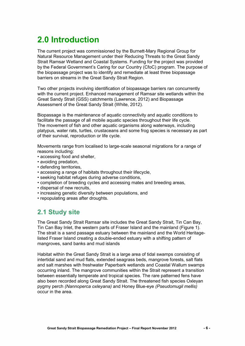
Assessment of the Great Sandy Strait (White, 2012). Biopassage is the maintenance of aquatic connectivity and aquatic conditions to facilitate the passage of all mobile aquatic species throughout their life cycle. The movement of fish and other aquatic organisms along waterways, including platypus, water rats, turtles, crustaceans and some frog species is necessary as part of their survival, reproduction or life cycle. Movements range from localised to large-scale seasonal migrations for a range of reasons including: • accessing food and shelter, • avoiding predation, • defending territories, • accessing a range of habitats throughout their lifecycle, • seeking habitat refuges during adverse conditions, • completion of breeding cycles and accessing mates and breeding areas, • dispersal of new recruits, • increasing genetic diversity between populations, and • repopulating areas after droughts.
2.1 Study site
The Great Sandy Strait Ramsar site includes the Great Sandy Strait, Tin Can Bay,
Tin Can Bay Inlet, the western parts of Fraser Island and the mainland (Figure 1).
The strait is a sand passage estuary between the mainland and the World Heritage-
listed Fraser Island creating a double-ended estuary with a shifting pattern of
mangroves, sand banks and mud islands
Habitat within the Great Sandy Strait is a large area of tidal swamps consisting of
intertidal sand and mud flats, extended seagrass beds, mangrove forests, salt flats
and salt marshes with freshwater Paperbark wetlands and Coastal Wallum swamps
occurring inland. The mangrove communities within the Strait represent a transition
between essentially temperate and tropical species. The rare patterned fens have
also been recorded along Great Sandy Strait. The threatened fish species Oxleyan
pygmy perch (Nannoperca oxleyana) and Honey Blue-eye (Pseudomugil mellis)
occur in the area.
Great Sandy Strait Biopassage Remediation Project – Final Report November 2012 - 7 -
3.0 Selection of Biopassage sites
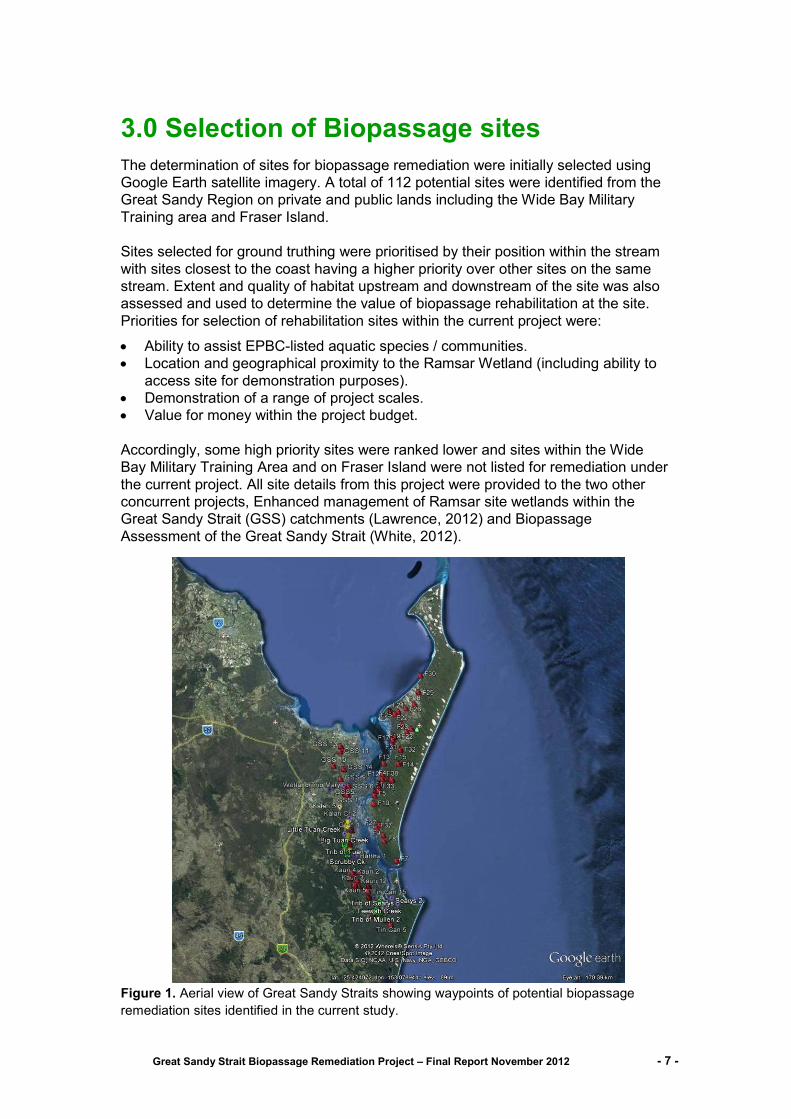
The determination of sites for biopassage remediation were initially selected using
Google Earth satellite imagery. A total of 112 potential sites were identified from the
Great Sandy Region on private and public lands including the Wide Bay Military
Training area and Fraser Island.
Sites selected for ground truthing were prioritised by their position within the stream
with sites closest to the coast having a higher priority over other sites on the same
stream. Extent and quality of habitat upstream and downstream of the site was also
assessed and used to determine the value of biopassage rehabilitation at the site.
Priorities for selection of rehabilitation sites within the current project were:
Ability to assist EPBC-listed aquatic species / communities.
Location and geographical proximity to the Ramsar Wetland (including ability to
access site for demonstration purposes).
Demonstration of a range of project scales.
Value for money within the project budget.
Accordingly, some high priority sites were ranked lower and sites within the Wide
Bay Military Training Area and on Fraser Island were not listed for remediation under
the current project. All site details from this project were provided to the two other
concurrent projects, Enhanced management of Ramsar site wetlands within the
Great Sandy Strait (GSS) catchments (Lawrence, 2012) and Biopassage
Assessment of the Great Sandy Strait (White, 2012).
Figure 1. Aerial view of Great Sandy Straits showing waypoints of potential biopassage
remediation sites identified in the current study.
Great Sandy Strait Biopassage Remediation Project – Final Report November 2012 - 8 -
A total of 43 sites were physically inspected and evaluated for potential biopassage
remediation under the current project. Six sites were selected for biopassage
remediation (Table 1) using the criteria detailed above and supported by the data
from the fish survey detailed in Section 4.
The Little Tuan Creek and Scrubby Creek sites were both culvert crossings over a
major road and are important tributaries of the Tuan Creek catchment. Opportunities
for biopassage rehabilitation at both sites was achieved with the installation of baffles
to disrupt the flow velocities through the culvert barrels.
The two sites Mullen Creek Lower and Trib of Mullen Ck were also the same type of
structure on the same system. Biopassage rehabilitation was achieved by adjusting
the stream gradient at the site and removing debris and man-made rock barriers.
The crossing at the Un-named Ck of Carland Ck inlet site effectively formed a low
weir that was a barrier to biopassage under all low to moderate flow conditions.
Biopassage at the site could be re-established by the installation of suitably sized
and baffled culverts or a complete removal or lowering of the structure.
Case studies detailing the biopassage rehabilitation works for each of the five sites
above are detailed in Section 5. Due to budgetary constraints within the current
project no rehabilitation works were performed at the Teewah Ck site. The
replacement of the current low capacity pipes with suitably sized and baffled culverts
is considered to be the most suitable solution for biopassage rehabilitation at this
site.
Table 1.The six sites selected for biopassage remediation within the current project.
Stream Name Nearest Town Ownership Structure
Type Remediation works
Little Tuan Ck Boonooroo Main Roads Built up road crossing Culvert type
Baffles on culvert walls.
Scrubby Ck Poona Main Roads Built up road crossing Culvert type
Baffles on culvert walls.
Trib of Mullen CK Tin Can Bay Gympie Regional Council
Low-level crossing
Re-instate stream gradient remove debris
Mullen Ck Lower Cooloola Cove Gympie Regional Council
Low-level crossing
Re-instate stream gradient remove debris
Un-named Ck of Carland Ck inlet
Cooloola Cove Gympie Regional Council
Built up road Crossing, No culvert
Remove structure or install culverts
Teewah Creek Tin Can Bay Gympie Regional Council
500mm pipe through road. Perched pipe.
Replace culvert pipes with rectangular box culvert
Great Sandy Strait Biopassage Remediation Project – Final Report November 2012 - 9 -
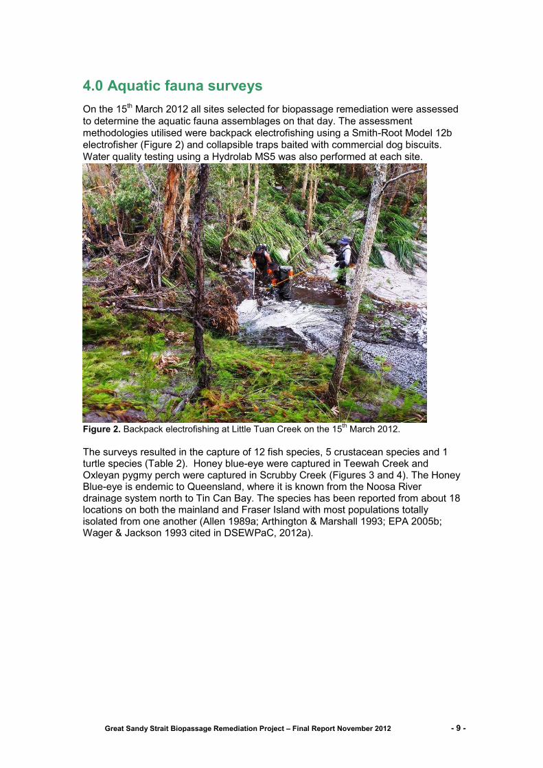
4.0 Aquatic fauna surveys
On the 15th March 2012 all sites selected for biopassage remediation were assessed
to determine the aquatic fauna assemblages on that day. The assessment
methodologies utilised were backpack electrofishing using a Smith-Root Model 12b
electrofisher (Figure 2) and collapsible traps baited with commercial dog biscuits.
Water quality testing using a Hydrolab MS5 was also performed at each site.
Figure 2. Backpack electrofishing at Little Tuan Creek on the 15th March 2012.
The surveys resulted in the capture of 12 fish species, 5 crustacean species and 1 turtle species (Table 2). Honey blue-eye were captured in Teewah Creek and Oxleyan pygmy perch were captured in Scrubby Creek (Figures 3 and 4). The Honey Blue-eye is endemic to Queensland, where it is known from the Noosa River drainage system north to Tin Can Bay. The species has been reported from about 18 locations on both the mainland and Fraser Island with most populations totally isolated from one another (Allen 1989a; Arthington & Marshall 1993; EPA 2005b; Wager & Jackson 1993 cited in DSEWPaC, 2012a).
Great Sandy Strait Biopassage Remediation Project – Final Report November 2012 - 10 -
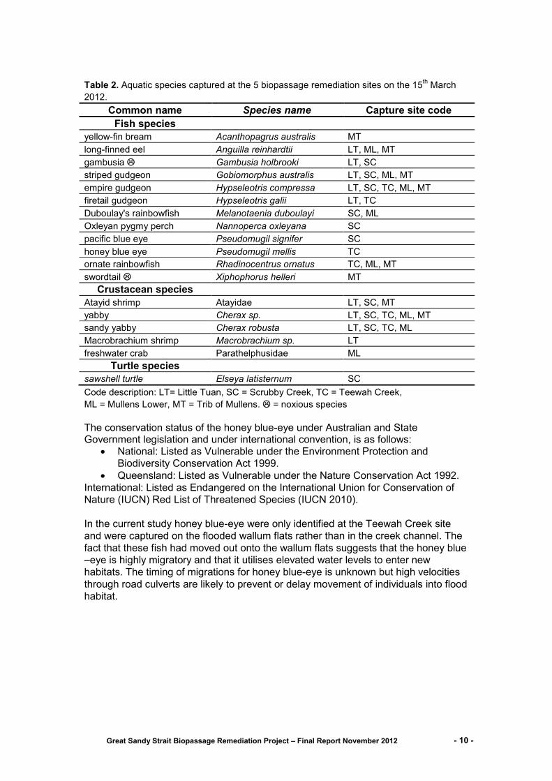
Table 2. Aquatic species captured at the 5 biopassage remediation sites on the 15th March
2012.
Common name Species name Capture site code
Fish species
yellow-fin bream Acanthopagrus australis MT
long-finned eel Anguilla reinhardtii LT, ML, MT
gambusia Gambusia holbrooki LT, SC
striped gudgeon Gobiomorphus australis LT, SC, ML, MT
empire gudgeon Hypseleotris compressa LT, SC, TC, ML, MT
firetail gudgeon Hypseleotris galii LT, TC
Duboulay's rainbowfish Melanotaenia duboulayi SC, ML
Oxleyan pygmy perch Nannoperca oxleyana SC
pacific blue eye Pseudomugil signifer SC
honey blue eye Pseudomugil mellis TC
ornate rainbowfish Rhadinocentrus ornatus TC, ML, MT
swordtail Xiphophorus helleri MT
Crustacean species
Atayid shrimp Atayidae LT, SC, MT
yabby Cherax sp. LT, SC, TC, ML, MT
sandy yabby Cherax robusta LT, SC, TC, ML
Macrobrachium shrimp Macrobrachium sp. LT
freshwater crab Parathelphusidae ML
Turtle species
sawshell turtle Elseya latisternum SC
Code description: LT= Little Tuan, SC = Scrubby Creek, TC = Teewah Creek,
ML = Mullens Lower, MT = Trib of Mullens. = noxious species
The conservation status of the honey blue-eye under Australian and State Government legislation and under international convention, is as follows:
National: Listed as Vulnerable under the Environment Protection and
Biodiversity Conservation Act 1999.
Queensland: Listed as Vulnerable under the Nature Conservation Act 1992.
International: Listed as Endangered on the International Union for Conservation of
Nature (IUCN) Red List of Threatened Species (IUCN 2010).
In the current study honey blue-eye were only identified at the Teewah Creek site
and were captured on the flooded wallum flats rather than in the creek channel. The
fact that these fish had moved out onto the wallum flats suggests that the honey blue
–eye is highly migratory and that it utilises elevated water levels to enter new
habitats. The timing of migrations for honey blue-eye is unknown but high velocities
through road culverts are likely to prevent or delay movement of individuals into flood
habitat.

Great Sandy Strait Biopassage Remediation Project – Final Report November 2012 - 11 -
Figure 3. Honey blue-eye captured at Teewah Creek on the 15th March 2012 .
The Oxleyan pygmy perch is restricted to coastal heath or wallum habitats (Leggett 1990) along the north coast of NSW and the south coast of Qld including Moreton Island (Lake 1971), Fraser Island (Wager 1992) and North Stradbroke Island (Arthington et al. 1996). Subtle differences in habitat and water quality or chance dispersal and extinction events, and the effects of recent habitat loss or degradation, appear to be the probable influences on the patchiness of this species throughout its geographical range (Arthington et al. 1996). Genetic analysis of six geographically isolated areas in Qld indicates that the levels of variation among populations of Nannoperca oxleyana are quite high. This suggests that dispersal among populations is extremely limited (Hughes et al. 1996). (DSEWPaC, 2012b). The current conservation status of the Oxleyan pygmy perch under Australian and State Government legislation and under international convention, is as follows:
National: Listed as Vulnerable under the Environment Protection and
Biodiversity Conservation Act 1999.
Queensland status: endangered and regulated under the Fisheries
(Freshwater) Management Plan 1993.
New South Wales: Recovery Plan for the Oxleyan pygmy perch (Nannoperca
oxleyana) (Department of Environment and Conservation, NSW, 2005) [State
Recovery Plan].
International: Listed as Endangered on the International Union for
Conservation of Nature (IUCN) Red List of Threatened Species (IUCN 2010).

Great Sandy Strait Biopassage Remediation Project – Final Report November 2012 - 12 -
Figure 4. Oxleyan pygmy perch captured at Scrubby Creek on the 15
th March 2012.
The occurrence of ornate rainbowfish has been documented from northern NSW to southern Qld in coastal streams as far north as Fraser Island with an isolated population identified in Waterpark Creek in central Qld. Ornate rainbowfish display within population colour morphs with individuals displaying either red or blue colourations. The dominant colouration of individuals in each population appears to determined by the level of tannin stain in the stream of origin. Red coloured individuals predominantly occur in highly stained waters and blue individuals from less stained waters (Hancox et al. 2010). The red coloured individual shown in Figure 5 below was captured from Teewah Creek, a highly tannin stained environment.
Figure 5. Ornate rainbowfish captured at Teewah Creek on the 15th March 2012 .
Great Sandy Strait Biopassage Remediation Project – Final Report November 2012 - 13 -
The noxious fish species gambusia was captured at the Little Tuan and Scrubby Creek sites and swordtail were captured at Mullens Upper site. Gambusia are an aggressive predator that attacks the fins of similar size and larger native fish and compete for food with native fish of the same trophic level. Swordtail are thought to be less aggressive than gambusia but are also highly fecund and would compete with native fish for food and habitat. The most abundant species at all sites was empire gudgeon, a highly migratory fish species that is often associated with coastal streams and is thought to benefit from free passage between estuarine and freshwater habitats. Similarly the striped gudgeon is known to utilise both estuarine and freshwater habitats although mass migrations have not been recorded. Eels and yellow-finned bream are catadromous and have an obligate requirement to spawn at sea and utilise freshwater habitats for food and shelter. All other fish species captured in the survey are potamodromous and may complete their life cycle entirely in freshwater. However as detailed in Section 2 for various reasons the free passage of all fish species is considered important and necessary.
Four species of crustacean were captured during the survey comprising of two
crayfish species, two shrimp species and one crab species. The importance of
migration for crustaceans captured in the current study has not been well
researched. Lee and Fielder (1979) documented the mass migration of
Macrobrachium australiense, which is most likely the same species captured in the
current study, climbing wetted vertical surfaces of dams. Migration was adversely
affected by rapidly flowing water. Large numbers of Macrobrachium sp. were
documented utilising the fishway to migrate upstream at the Paradise Dam
exclusively during low flow releases (DEEDI, Fisheries Qld, 2011). The results of
both of the abovementioned studies indicate low water velocities are vital for
successful migration of Macrobrachium spp.
At least two species of crayfish indigenous to south-eastern Queensland, the sand
yabby (Cherax robustus) (Figure 6) and swamp yabby (Tenuibranchiurus glypticus),
are particularly vulnerable to habitat loss and urban development. Lowering of the
water table, drainage of swamps, construction of roads and housing estates and
increased levels of pollution are all potentially threatening. The sand yabby (Cherax
robustus) is found only in wallum heathlands; adapted to living in soft acidic waters in
peaty sand areas. Restricted to coastal South-eastern Queensland as far north as
Fraser Island (Qld Museum Sciencentre, Sand Yabby, Cherax robustus, 2012).
In the current study the sand yabby was captured from all sites apart from Mullen
Upper. The migratory requirements of the sand yabby are unknown but it is likely to
be similar to other Cherax spp. in that has the ability to travel overland and is likely to
utilise elevated water levels to access new habitats. High water velocities through
culvert crossings and the construction of physically impassable culvert headwalls or
road decks are likely to impact on the successful passage of the sand yabby.
Great Sandy Strait Biopassage Remediation Project – Final Report November 2012 - 14 -
Figure 6. Sand yabby captured at Teewah Creek on the 15th March 2012.
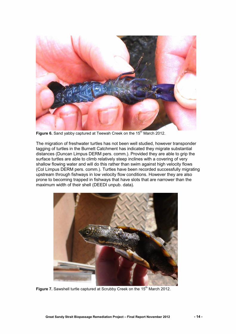
The migration of freshwater turtles has not been well studied, however transponder
tagging of turtles in the Burnett Catchment has indicated they migrate substantial
distances (Duncan Limpus DERM pers. comm.). Provided they are able to grip the
surface turtles are able to climb relatively steep inclines with a covering of very
shallow flowing water and will do this rather than swim against high velocity flows
(Col Limpus DERM pers. comm.). Turtles have been recorded successfully migrating
upstream through fishways in low velocity flow conditions. However they are also
prone to becoming trapped in fishways that have slots that are narrower than the
maximum width of their shell (DEEDI unpub. data).
Figure 7. Sawshell turtle captured at Scrubby Creek on the 15th March 2012.
Great Sandy Strait Biopassage Remediation Project – Final Report November 2012 - 15 -
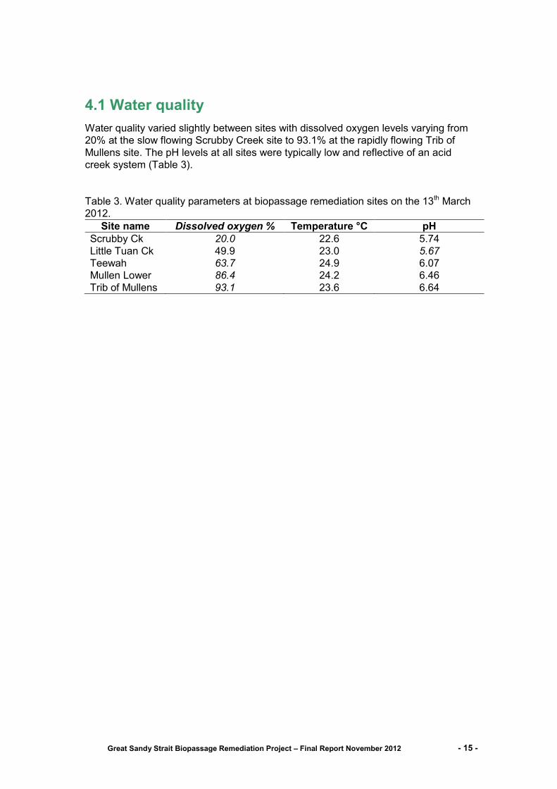
4.1 Water quality
Water quality varied slightly between sites with dissolved oxygen levels varying from
20% at the slow flowing Scrubby Creek site to 93.1% at the rapidly flowing Trib of
Mullens site. The pH levels at all sites were typically low and reflective of an acid
creek system (Table 3).
Table 3. Water quality parameters at biopassage remediation sites on the 13th March
2012.
Site name Dissolved oxygen % Temperature °C pH
Scrubby Ck 20.0 22.6 5.74
Little Tuan Ck 49.9 23.0 5.67
Teewah 63.7 24.9 6.07
Mullen Lower 86.4 24.2 6.46
Trib of Mullens 93.1 23.6 6.64
Great Sandy Strait Biopassage Remediation Project – Final Report November 2012 - 16 -
5.0 Case studies for sites selected for Biopassage remediation
Biopassage remediation works were performed at five of the six sites selected within
the current project. The following section provides case study details on the works
performed.
Site name: Little Tuan Creek Southing: 25.664122°
System: Little Tuan Creek Easting: 152.845818°
Nearest town: Boonooroo Approximate distance from coast: 5.79 km
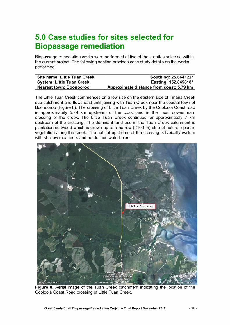
The Little Tuan Creek commences on a low rise on the eastern side of Tinana Creek
sub-catchment and flows east until joining with Tuan Creek near the coastal town of
Boonooroo (Figure 8). The crossing of Little Tuan Creek by the Cooloola Coast road
is approximately 5.79 km upstream of the coast and is the most downstream
crossing of the creek. The Little Tuan Creek continues for approximately 7 km
upstream of the crossing. The dominant land use in the Tuan Creek catchment is
plantation softwood which is grown up to a narrow (<100 m) strip of natural riparian
vegetation along the creek. The habitat upstream of the crossing is typically wallum
with shallow meanders and no defined waterholes.
Figure 8. Aerial image of the Tuan Creek catchment indicating the location of the
Cooloola Coast Road crossing of Little Tuan Creek.

Great Sandy Strait Biopassage Remediation Project – Final Report November 2012 - 17 -
The Little Tuan Creek crossing is a six cell rectangular box culvert set on a concrete
base that is perched above the natural level of the creek bed and approximately
equal to the commence to flow water level (Figure 9). The crossing was identified as
a barrier to fish movement during low to moderate flows. In a natural creek bed the
water forms a defined low flow channel of varying depths. Low flows over the
crossing pass through all six culvert barrels creating a shallow laminar flow that
restricts fish passage and increases predation by birds. No hydraulic studies of the
culvert were performed; however it is likely that at higher flows the increased water
velocities create a barrier to the successful passage of fish.
Figure 9. Cooloola Coast Road crossing of Little Tuan Creek prior to biopassage
remediation.
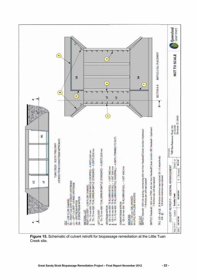
The biopassage remediation works for the Little Tuan Crossing consisted of the
installation of low sills on the culvert base and baffles on the outside culvert walls
(Figure 10). The function of the sills is to block low flows through five of the culvert
barrels thereby increasing the depth in the right bank side culvert to create a low flow
pathway for fish. The function of the baffles is to disrupt the flow patterns on the
culvert walls in a similar way to the natural vegetation in a creek. Baffles fitted to both
walls of the designated low flow culvert and to the outside wall of the left bank culvert
provide the best combination of hydraulic conditions for biopassage in multi-cell
culvert arrays.
Great Sandy Strait Biopassage Remediation Project – Final Report November 2012 - 18 -
Figure 10. Schematic of culvert retrofit for biopassage remediation at the Little Tuan
Creek site.
Great Sandy Strait Biopassage Remediation Project – Final Report November 2012 - 19 -
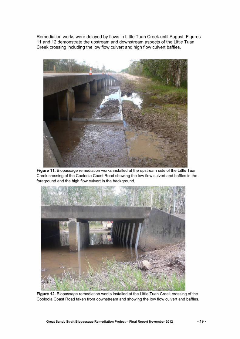
Remediation works were delayed by flows in Little Tuan Creek until August. Figures
11 and 12 demonstrate the upstream and downstream aspects of the Little Tuan
Creek crossing including the low flow culvert and high flow culvert baffles.
Figure 11. Biopassage remediation works installed at the upstream side of the Little Tuan
Creek crossing of the Cooloola Coast Road showing the low flow culvert and baffles in the
foreground and the high flow culvert in the background.
Figure 12. Biopassage remediation works installed at the Little Tuan Creek crossing of the
Cooloola Coast Road taken from downstream and showing the low flow culvert and baffles.

Great Sandy Strait Biopassage Remediation Project – Final Report November 2012 - 20 -
Site name: Scrubby Creek Southing: 25.747170°
System: Tuan Creek Easting: 152.857190°
Nearest town: Poona Approximate distance from coast: 10.21 km
Scrubby Creek is a southern tributary of Tuan Creek that commences on a low rise
adjacent to Logging Creek on the Tinana Creek sub-catchment and flows east until
joining with Tuan Creek near the coastal town of Boonooroo (Figure 13). The
crossing of Scrubby Creek by the Cooloola Coast road is approximately 10.2 km
upstream from the coast and is the most downstream crossing of the creek. Scrubby
Creek continues for approximately 8 km upstream of the crossing. The dominant
land use in the Tuan Creek catchment is plantation softwood which is grown up to a
narrow (<100 m) strip of natural riparian vegetation along the creek. The habitat
upstream of the crossing is typically wallum with shallow meanders and no defined
waterholes.
Figure 13. Aerial image of the Tuan Creek catchment indicating the location of the
Cooloola Coast Road crossing of Scrubby Creek
The Scrubby Creek crossing is a four cell rectangular box culvert set on a concrete
base that is perched above the natural level of the creek bed and slightly below the
commence to flow water level (Figure 14). The unmodified crossing was a barrier to
fish movement during low to moderate flows. In a natural creek bed the water forms
a defined low flow channel of varying depths. Low flows over the crossing pass
through all four culvert barrels creating a shallow laminar flow that restricts fish
passage and increases predation by birds. No hydraulic studies of the culvert were
performed; however it is likely that at elevated flows the higher water velocities
create a barrier for the passage of fish.
Great Sandy Strait Biopassage Remediation Project – Final Report November 2012 - 21 -
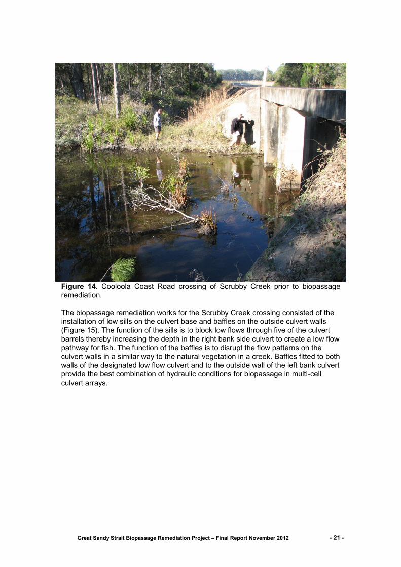
Figure 14. Cooloola Coast Road crossing of Scrubby Creek prior to biopassage
remediation.
The biopassage remediation works for the Scrubby Creek crossing consisted of the
installation of low sills on the culvert base and baffles on the outside culvert walls
(Figure 15). The function of the sills is to block low flows through five of the culvert
barrels thereby increasing the depth in the right bank side culvert to create a low flow
pathway for fish. The function of the baffles is to disrupt the flow patterns on the
culvert walls in a similar way to the natural vegetation in a creek. Baffles fitted to both
walls of the designated low flow culvert and to the outside wall of the left bank culvert
provide the best combination of hydraulic conditions for biopassage in multi-cell
culvert arrays.
Great Sandy Strait Biopassage Remediation Project – Final Report November 2012 - 22 -
Figure 15. Schematic of culvert retrofit for biopassage remediation at the Little Tuan
Creek site.

Great Sandy Strait Biopassage Remediation Project – Final Report November 2012 - 23 -
Remediation works were completed in May 2012. Almost immediately following
baffle installation a local rainfall event caused a minor flow in Scrubby Creek. Figure
16 below shows the low flow culvert during this flow event and also demonstrates the
effect that the baffles have on the flow patterns within the low flow culvert.
Figure 16. Biopassage remediation works installed at the Scrubby Creek crossing of the
Cooloola Coast Road showing the low flow culvert and baffles.
No assessment of the biopassage effectiveness of the culvert modifications were
performed in the current study. However a recent study of the improved passage of
fish through a single baffled culvert is documented in Berghuis (2012).
Great Sandy Strait Biopassage Remediation Project – Final Report November 2012 - 24 -
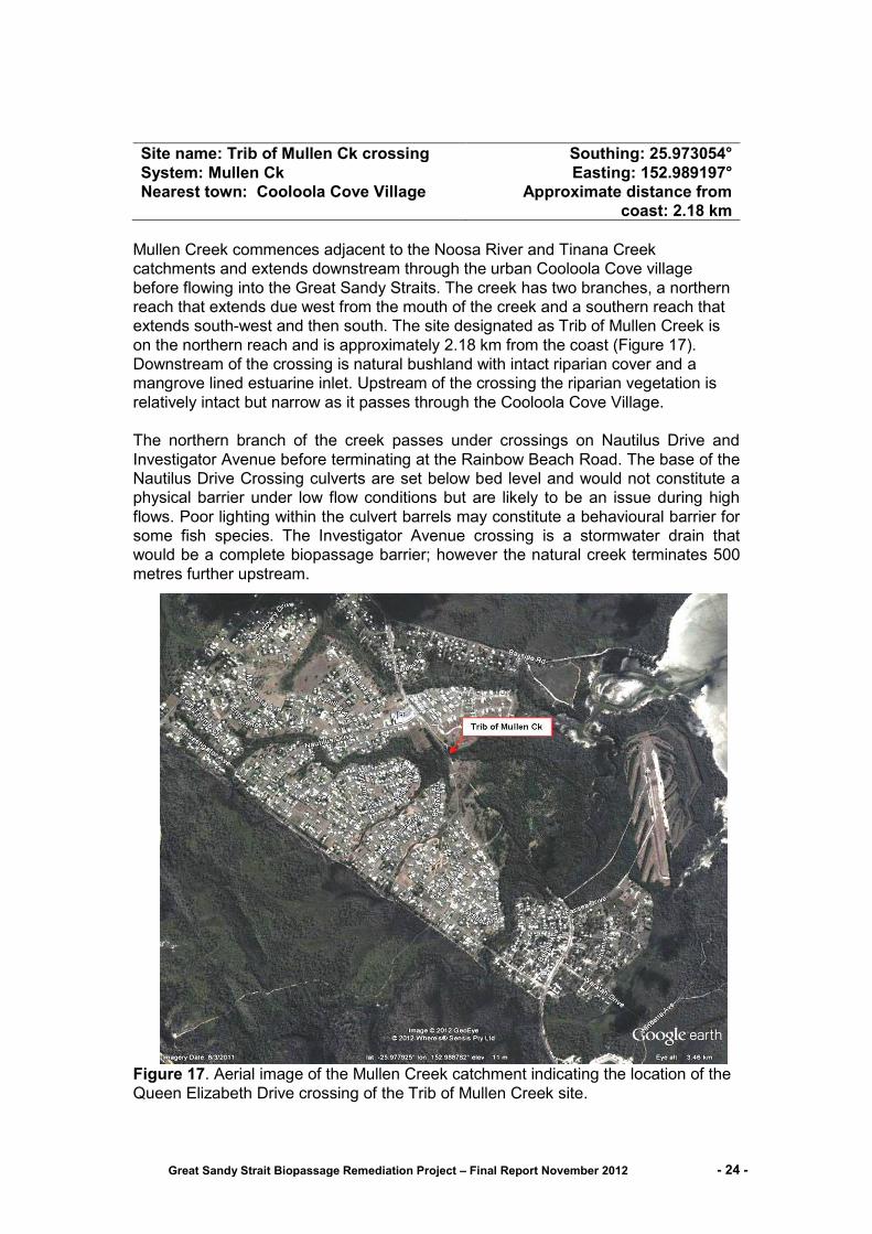
Site name: Trib of Mullen Ck crossing Southing: 25.973054°
System: Mullen Ck Easting: 152.989197°
Nearest town: Cooloola Cove Village Approximate distance from
coast: 2.18 km
Mullen Creek commences adjacent to the Noosa River and Tinana Creek
catchments and extends downstream through the urban Cooloola Cove village
before flowing into the Great Sandy Straits. The creek has two branches, a northern
reach that extends due west from the mouth of the creek and a southern reach that
extends south-west and then south. The site designated as Trib of Mullen Creek is
on the northern reach and is approximately 2.18 km from the coast (Figure 17).
Downstream of the crossing is natural bushland with intact riparian cover and a
mangrove lined estuarine inlet. Upstream of the crossing the riparian vegetation is
relatively intact but narrow as it passes through the Cooloola Cove Village.
The northern branch of the creek passes under crossings on Nautilus Drive and
Investigator Avenue before terminating at the Rainbow Beach Road. The base of the
Nautilus Drive Crossing culverts are set below bed level and would not constitute a
physical barrier under low flow conditions but are likely to be an issue during high
flows. Poor lighting within the culvert barrels may constitute a behavioural barrier for
some fish species. The Investigator Avenue crossing is a stormwater drain that
would be a complete biopassage barrier; however the natural creek terminates 500
metres further upstream.
Figure 17. Aerial image of the Mullen Creek catchment indicating the location of the
Queen Elizabeth Drive crossing of the Trib of Mullen Creek site.
Great Sandy Strait Biopassage Remediation Project – Final Report November 2012 - 25 -
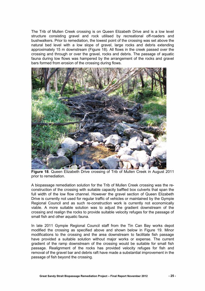
The Trib of Mullen Creek crossing is on Queen Elizabeth Drive and is a low level
structure consisting gravel and rock utilised by recreational off-roaders and
bushwalkers. Prior to remediation, the lowest point of the crossing was set above the
natural bed level with a low slope of gravel, large rocks and debris extending
approximately 15 m downstream (Figure 18). All flows in the creek passed over the
crossing and through or over the gravel, rocks and debris. The passage of aquatic
fauna during low flows was hampered by the arrangement of the rocks and gravel
bars formed from erosion of the crossing during flows.
Figure 18. Queen Elizabeth Drive crossing of Trib of Mullen Creek in August 2011
prior to remediation.
A biopassage remediation solution for the Trib of Mullen Creek crossing was the re-
construction of the crossing with suitable capacity baffled box culverts that span the
full width of the low flow channel. However the gravel section of Queen Elizabeth
Drive is currently not used for regular traffic of vehicles or maintained by the Gympie
Regional Council and as such re-construction work is currently not economically
viable. A more suitable solution was to adjust the gradient downstream of the
crossing and realign the rocks to provide suitable velocity refuges for the passage of
small fish and other aquatic fauna.
In late 2011 Gympie Regional Council staff from the Tin Can Bay works depot
modified the crossing as specified above and shown below in Figure 19. Minor
modifications to the crossing and the area downstream to facilitate fish passage
have provided a suitable solution without major works or expense. The current
gradient of the ramp downstream of the crossing would be suitable for small fish
passage. Realignment of the rocks has provided velocity refuges for fish and
removal of the gravel bar and debris raft have made a substantial improvement in the
passage of fish beyond the crossing.
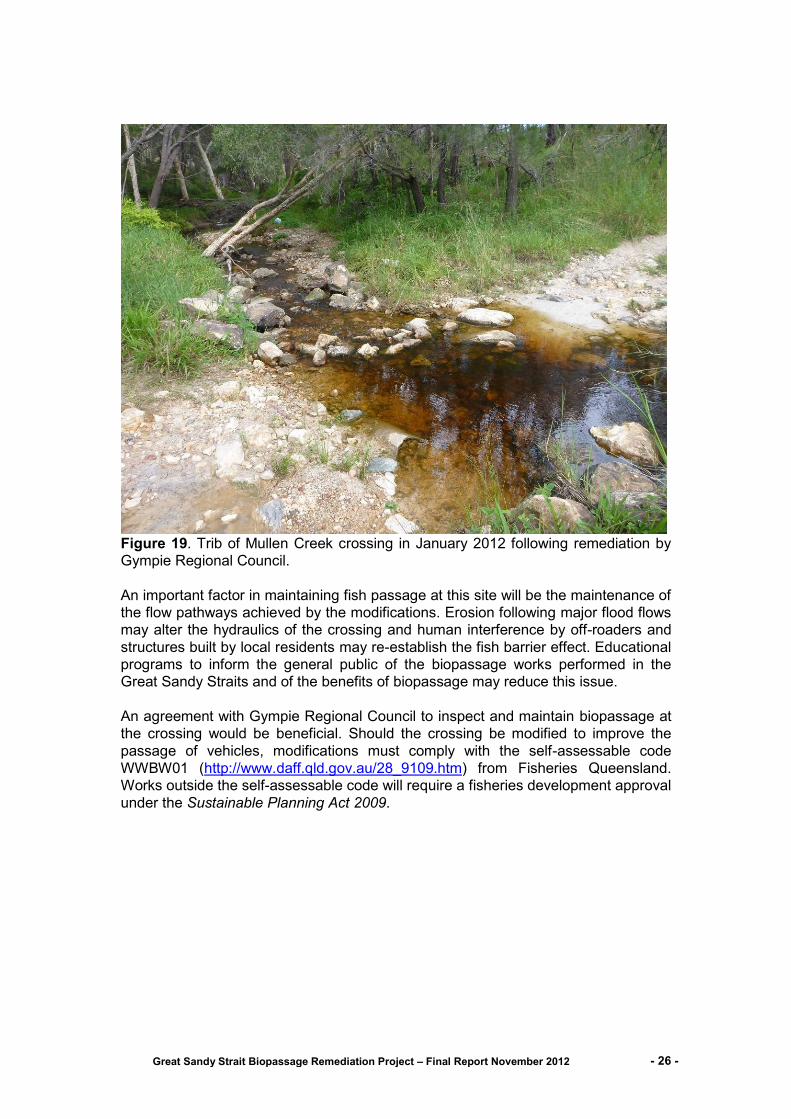
Great Sandy Strait Biopassage Remediation Project – Final Report November 2012 - 26 -
Figure 19. Trib of Mullen Creek crossing in January 2012 following remediation by
Gympie Regional Council.
An important factor in maintaining fish passage at this site will be the maintenance of
the flow pathways achieved by the modifications. Erosion following major flood flows
may alter the hydraulics of the crossing and human interference by off-roaders and
structures built by local residents may re-establish the fish barrier effect. Educational
programs to inform the general public of the biopassage works performed in the
Great Sandy Straits and of the benefits of biopassage may reduce this issue.
An agreement with Gympie Regional Council to inspect and maintain biopassage at
the crossing would be beneficial. Should the crossing be modified to improve the
passage of vehicles, modifications must comply with the self-assessable code
WWBW01 (http://www.daff.qld.gov.au/28_9109.htm) from Fisheries Queensland.
Works outside the self-assessable code will require a fisheries development approval
under the Sustainable Planning Act 2009.

Great Sandy Strait Biopassage Remediation Project – Final Report November 2012 - 27 -
Site name: Mullen Ck lower Southing: 25.982160°
System: Mullen Creek Easting: 152.996497°
Nearest town: Cooloola Cove Village Approximate distance from
coast: 3.04 km
Mullen Creek commences adjacent to the Noosa River and Tinana Creek
catchments and extends downstream through the urban Cooloola Cove Village
before flowing into the Great Sandy Straits. The creek has two branches, a northern
reach that extends due west from the mouth of the creek and a southern reach that
extends south-west and then south. The site designated Mullen Creek lower is on
the southern reach and is approximately 3.04 km from the coast (Figure 20).
Downstream of the crossing is natural bushland with intact riparian cover and the
mangrove lined inlet. Upstream of the crossing the riparian vegetation is relatively
intact but narrow as it passes through Cooloola Cove Village. The creek passes
under a crossing on Investigator Avenue before terminating at the Rainbow Beach
Road. The Investigator Avenue crossing is likely to be a major biopassage barrier
under all flow conditions. The creek terminates approximately 2 km upstream of the
crossing.
Figure 20. Aerial view of the Mullen Creek catchment indicating the location of the
Queen Elizabeth Drive crossing of the Mullen Creek Lower site
Great Sandy Strait Biopassage Remediation Project – Final Report November 2012 - 28 -
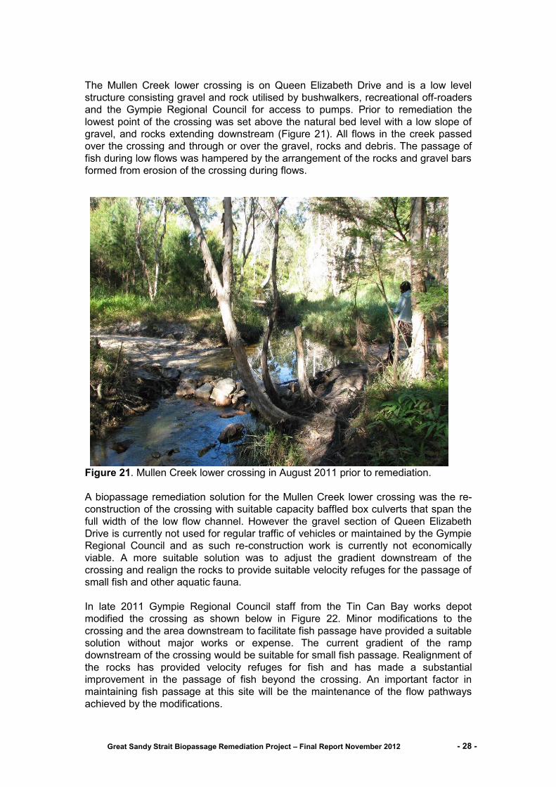
The Mullen Creek lower crossing is on Queen Elizabeth Drive and is a low level
structure consisting gravel and rock utilised by bushwalkers, recreational off-roaders
and the Gympie Regional Council for access to pumps. Prior to remediation the
lowest point of the crossing was set above the natural bed level with a low slope of
gravel, and rocks extending downstream (Figure 21). All flows in the creek passed
over the crossing and through or over the gravel, rocks and debris. The passage of
fish during low flows was hampered by the arrangement of the rocks and gravel bars
formed from erosion of the crossing during flows.
Figure 21. Mullen Creek lower crossing in August 2011 prior to remediation.
A biopassage remediation solution for the Mullen Creek lower crossing was the re-
construction of the crossing with suitable capacity baffled box culverts that span the
full width of the low flow channel. However the gravel section of Queen Elizabeth
Drive is currently not used for regular traffic of vehicles or maintained by the Gympie
Regional Council and as such re-construction work is currently not economically
viable. A more suitable solution was to adjust the gradient downstream of the
crossing and realign the rocks to provide suitable velocity refuges for the passage of
small fish and other aquatic fauna.
In late 2011 Gympie Regional Council staff from the Tin Can Bay works depot
modified the crossing as shown below in Figure 22. Minor modifications to the
crossing and the area downstream to facilitate fish passage have provided a suitable
solution without major works or expense. The current gradient of the ramp
downstream of the crossing would be suitable for small fish passage. Realignment of
the rocks has provided velocity refuges for fish and has made a substantial
improvement in the passage of fish beyond the crossing. An important factor in
maintaining fish passage at this site will be the maintenance of the flow pathways
achieved by the modifications.
Great Sandy Strait Biopassage Remediation Project – Final Report November 2012 - 29 -
Figure 22. Mullen Creek lower crossing in January 2012 following remediation by
Gympie Regional Council.
Erosion following major flood flows may alter the hydraulics of the crossing and
human interference by off-roaders and structures built by local residents may re-
establish the fish barrier effect. Educational programs to inform the general public of
the biopassage works performed in the Great Sandy Straits and of the benefits of
biopassage may reduce this issue.
An agreement with Gympie Regional Council to inspect and maintain biopassage at
the crossing would be beneficial. Should the crossing be modified to improve the
passage of vehicles, modifications must comply with the self-assessable code
WWBW01 (http://www.daff.qld.gov.au/28_9109.htm) from Fisheries Queensland.
Works outside the self-assessable code will require a fisheries development approval
under the Sustainable Planning Act 2009.
Great Sandy Strait Biopassage Remediation Project – Final Report November 2012 - 30 -
Site name: Un- named Creek of Carland Ck inlet Southing: 25.995955°
System: Carland Creek Easting: 153.007783°
Nearest town: Cooloola Cove Approximate distance
from coast: 1.41 km
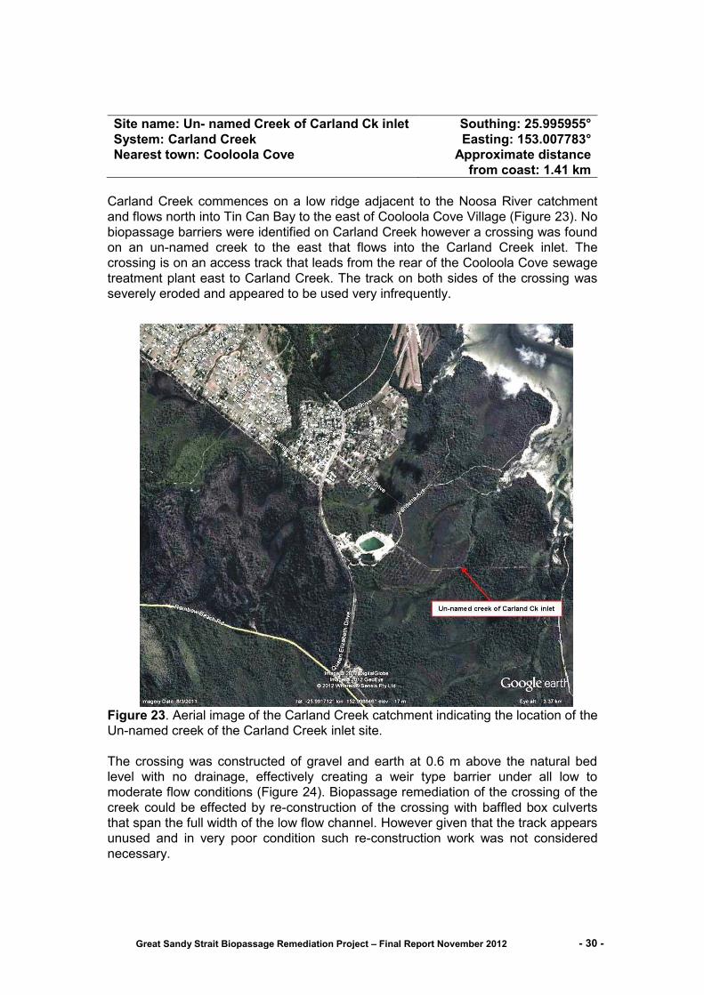
Carland Creek commences on a low ridge adjacent to the Noosa River catchment
and flows north into Tin Can Bay to the east of Cooloola Cove Village (Figure 23). No
biopassage barriers were identified on Carland Creek however a crossing was found
on an un-named creek to the east that flows into the Carland Creek inlet. The
crossing is on an access track that leads from the rear of the Cooloola Cove sewage
treatment plant east to Carland Creek. The track on both sides of the crossing was
severely eroded and appeared to be used very infrequently.
Figure 23. Aerial image of the Carland Creek catchment indicating the location of the
Un-named creek of the Carland Creek inlet site.
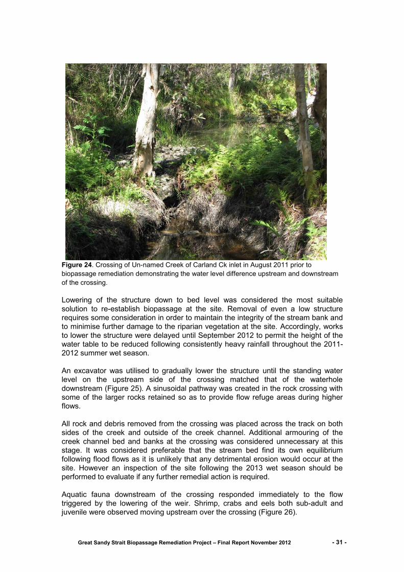
The crossing was constructed of gravel and earth at 0.6 m above the natural bed
level with no drainage, effectively creating a weir type barrier under all low to
moderate flow conditions (Figure 24). Biopassage remediation of the crossing of the
creek could be effected by re-construction of the crossing with baffled box culverts
that span the full width of the low flow channel. However given that the track appears
unused and in very poor condition such re-construction work was not considered
necessary.
Great Sandy Strait Biopassage Remediation Project – Final Report November 2012 - 31 -
Figure 24. Crossing of Un-named Creek of Carland Ck inlet in August 2011 prior to
biopassage remediation demonstrating the water level difference upstream and downstream
of the crossing.
Lowering of the structure down to bed level was considered the most suitable
solution to re-establish biopassage at the site. Removal of even a low structure
requires some consideration in order to maintain the integrity of the stream bank and
to minimise further damage to the riparian vegetation at the site. Accordingly, works
to lower the structure were delayed until September 2012 to permit the height of the
water table to be reduced following consistently heavy rainfall throughout the 2011-
2012 summer wet season.
An excavator was utilised to gradually lower the structure until the standing water
level on the upstream side of the crossing matched that of the waterhole
downstream (Figure 25). A sinusoidal pathway was created in the rock crossing with
some of the larger rocks retained so as to provide flow refuge areas during higher
flows.
All rock and debris removed from the crossing was placed across the track on both
sides of the creek and outside of the creek channel. Additional armouring of the
creek channel bed and banks at the crossing was considered unnecessary at this
stage. It was considered preferable that the stream bed find its own equilibrium
following flood flows as it is unlikely that any detrimental erosion would occur at the
site. However an inspection of the site following the 2013 wet season should be
performed to evaluate if any further remedial action is required.
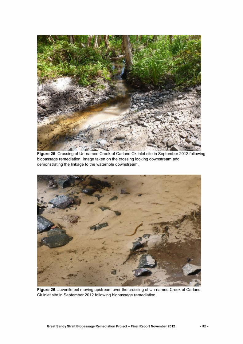
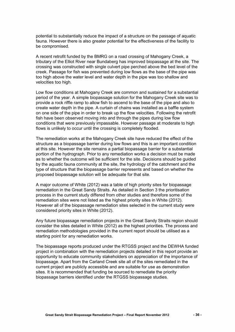
Aquatic fauna downstream of the crossing responded immediately to the flow
triggered by the lowering of the weir. Shrimp, crabs and eels both sub-adult and
juvenile were observed moving upstream over the crossing (Figure 26).
Great Sandy Strait Biopassage Remediation Project – Final Report November 2012 - 32 -
Figure 25. Crossing of Un-named Creek of Carland Ck inlet site in September 2012 following
biopassage remediation. Image taken on the crossing looking downstream and
demonstrating the linkage to the waterhole downstream.
Figure 26. Juvenile eel moving upstream over the crossing of Un-named Creek of Carland
Ck inlet site in September 2012 following biopassage remediation.

Great Sandy Strait Biopassage Remediation Project – Final Report November 2012 - 33 -
Site name: Teewah Creek crossing Southing: 25.939370°
System: Teewah Creek Easting: 152.995060°
Nearest town: Tin Can bay Approximate distance from coast: 3.18
km
Teewah Creek commences on a low ridge bordered by Bayside Road and flows
north-east into Tin Can Bay terminating to the south of Tin Can Bay Township
(Figure 27). The crossing of Teewah Creek is on Teewah Point Road a public road
that is used to access private properties and Teewah Point in the great Sandy
Straits. The crossing is approximately 3.18 km from the coast. Upstream of the
crossing is natural bushland with intact riparian cover and shallow but high quality
waterholes and downstream is paperbark wetland and the mangrove lined estuarine
inlet. The crossing is the only artificial barrier on the creek which terminates
approximately 2.5 km upstream. The quality of the habitat and data from the fish
survey in March 2012 indicates that remediation of biopassage to the crossing
should be given a high priority
Figure 27. Aerial image of the Teewah Creek catchment indicating the location of
the Teewah Creek crossing site on the Teewah Point Road.

Great Sandy Strait Biopassage Remediation Project – Final Report November 2012 - 34 -
The Teewah Creek crossing spans an approximately 4m low flow channel with flow
directed through a 0.5 m wide concrete pipe. The base of the pipe is set above the
natural creek bed level but 0.34 m below the commence to flow water level on the
downstream side (Figure 28).
Biopassage remediation could be effected by re-construction of the crossing with a
single 2.4 m wide box culvert that spans the low flow channel with baffling of the
culvert walls and roughness in the culvert base.
Figure 28. Downstream side of the Teewah Point Road crossing of Teewah Creek.
No biopassage remediation works were performed within the current project at the
Teewah Creek crossing. A cost estimate for the removal of the current pipe culvert
and replacement with a baffled 2.4 m wide box culvert was estimated by Gympie
Regional Council to be a minimum of $60,000 (Greg Ingham GRC pers com.). The
cost of remediating this site was beyond the budget of the current project. Funds of
approximately $15,000 were committed from an underspend in the Federal
Government funded Enhanced management of Ramsar site wetlands within the
Great Sandy Strait (GSS) catchments project. However no other funds to make up
the $45,000 shortfall were able to be sourced and the $15,000 was returned to the
funding body.
Biopassage remediation of the Teewah Creek crossing must continue to be a
priority. The ongoing development of South-east Queensland for residential housing
will intensify the impact on systems such as Teewah Creek. Measures to protect and
enhance aquatic systems in the Great Sandy Straits region will build resilience within
Enhanced management of Ramsar site wetlands within the Great Sandy Strait (GSS)
catchments these systems.

Great Sandy Strait Biopassage Remediation Project – Final Report November 2012 - 35 -
6.0 Future Biopassage Remediation
The initial decision process for remediating an existing biopassage barrier is detailed in the flowchart below (Figure 29). The first consideration when a biopassage barrier is identified should always be the option for removal of the structure or in the case of a stream crossing the construction of a bridge. A well planned weir removal or a suitably designed bridge has the potential to completely alleviate the barrier effect of a structure.
The cost of biopassage remediation is always a major consideration and the decision
not to completely alleviate the barrier effect of a structure is almost always an
economic one. Mitigation of the impacts of a waterway barrier requires consideration
as to whether the existing structure can be retrofitted or has to be replaced in order
to provide biopassage. Mitigation works have the potential to completely alleviate the
barrier effect, however this is rarely achieved.
It should be clear as to what the objective of the biopassage works is intended to be.
Replacement of the entire structure provides the opportunity to design the best
mitigation solution practical. An example of this is the Teewah Point Rd crossing of
Teewah Ck where replacement of small capacity pipes with a greater capacity
baffled rectangular box culvert. The suggested mitigation works would have resulted
in effective biopassage through the culvert for all low to moderate flows and over the
crossing on higher flows. Figure 29. Flowchart process for the provision of fish passage at new and existing waterway barriers.
The decision to retrofit a structure for biopassage rather than replace it is usually an
economic one. The retrofitting of an existing structure to provide biopassage has the
Barrier
Retrofit?
Mitigate
Removal or bridge?
Replace?
100% biopassage remediation achieved
Design options limited by existing structure, high potential for
compromises to functionality
Design options less limited by existing structure, greater opportunity to
maximise functionality
≈ 30% - 80% biopassage remediation achieved
≈ 60% - 100% biopassage remediation achieved
Great Sandy Strait Biopassage Remediation Project – Final Report November 2012 - 36 -
potential to substantially reduce the impact of a structure on the passage of aquatic
fauna. However there is also greater potential for the effectiveness of the facility to
be compromised.
A recent retrofit funded by the BMRG on a road crossing of Mahogany Creek, a
tributary of the Elliot River near Bundaberg has improved biopassage at the site. The
crossing was constructed with single culvert pipe perched above the bed level of the
creek. Passage for fish was prevented during low flows as the base of the pipe was
too high above the water level and water depth in the pipe was too shallow and
velocities too high.
Low flow conditions at Mahogany Creek are common and sustained for a substantial
period of the year. A simple biopassage solution for the Mahogany Creek site was to
provide a rock riffle ramp to allow fish to ascend to the base of the pipe and also to
create water depth in the pipe. A curtain of chains was installed as a baffle system
on one side of the pipe in order to break up the flow velocities. Following the retrofit
fish have been observed moving into and through the pipes during low flow
conditions that were previously impassable. However passage at moderate to high
flows is unlikely to occur until the crossing is completely flooded.
The remediation works at the Mahogany Creek site have reduced the effect of the
structure as a biopassage barrier during low flows and this is an important condition
at this site. However the site remains a partial biopassage barrier for a substantial
portion of the hydrograph. Prior to any remediation works a decision must be made
as to whether the outcome will be sufficient for the site. Decisions should be guided
by the aquatic fauna community at the site, the hydrology of the catchment and the
type of structure that the biopassage barrier represents and based on whether the
proposed biopassage solution will be adequate for that site.
A major outcome of White (2012) was a table of high priority sites for biopassage
remediation in the Great Sandy Straits. As detailed in Section 3 the prioritisation
process in the current study differed from other studies and therefore some of the
remediation sites were not listed as the highest priority sites in White (2012).
However all of the biopassage remediation sites selected in the current study were
considered priority sites in White (2012).
Any future biopassage remediation projects in the Great Sandy Straits region should
consider the sites detailed in White (2012) as the highest priorities. The process and
remediation methodologies provided in the current report should be utilised as a
starting point for any remediation works.
The biopassage reports produced under the RTGSS project and the DEWHA funded
project in combination with the remediation projects detailed in this report provide an
opportunity to educate community stakeholders on appreciation of the importance of
biopassage. Apart from the Carland Creek site all of the sites remediated in the
current project are publicly accessible and are suitable for use as demonstration
sites. It is recommended that funding be sourced to remediate the priority
biopassage barriers identified under the RTGSS biopassage studies.

Great Sandy Strait Biopassage Remediation Project – Final Report November 2012 - 37 -
7.0 Additional project activities
2011-2012, attendance and reporting to Biopassage Technical Working
Group on project progress.
Attendance at and participation in RTGSS steering committee meetings.
Contribution of site data and expertise to Enhanced management of Ramsar
site wetlands within the Great Sandy Strait (GSS) catchments (Lawrence,
2012)
Contribution of site data and expertise to Biopassage Assessment of the
Great Sandy Strait (White, 2012).
May 2012, Presentation on Great Sandy Strait Biopassage Remediation
Project Cooloola Coastcare Association.
November 2012 Media release to BMRG on Great Sandy Strait Biopassage
Remediation Project.

Great Sandy Strait Biopassage Remediation Project – Final Report November 2012 - 38 -
8.0 References
Berghuis (2012). Kenzlers Road culvert upgrade for fish passage. Department of
Agriculture, Fisheries and Forestry, 16 pp.
DEEDI Fisheries Qld (Broadfoot, C.D. and Berghuis, A.P.) (2011) Paradise Dam Upstream Fishway Monitoring Program Final Report, for Burnett Water Pty Ltd, contract dated 5 September 2007, 85pp.
Department of Sustainability, Environment, Water, Population and Communities
(2012a). Pseudomugil mellis in Species Profile and Threats Database, Department
of Sustainability, Environment, Water, Population and Communities, Canberra.
Available from: http://www.environment.gov.au/sprat. Accessed Mon, 13 Aug 2012.
Department of Sustainability, Environment, Water, Population and Communities
(2012b). Nannoperca oxleyana in Species Profile and Threats Database,
Department of Sustainability, Environment, Water, Population and Communities,
Canberra. Available from: http://www.environment.gov.au/sprat. Accessed Mon, 13
Aug 2012.
Hancox, D., C. J. Hoskin, et al. (2010). "Evening up the score: sexual selection
favours both alternatives in the colour-polymorphic ornate rainbowfish." Animal
Behaviour 80 (5): 845-851.
Lawrence, M, Sully, D, Couchman, D and Beumer, J (2012). Enhanced
management of Ramsar site wetlands within the Great Sandy Strait
catchments. Final Report to the Department of Environment, Water, Heritage and the
Arts. Fisheries Queensland (previously the Department of Employment, Economic
Development and Innovation), Department of Agriculture, Fisheries and Forestry,
77 pp (+++ Teewah Creek Appendix).
Lawrence, M, Sully, D, Couchman, D and Beumer, J (2012). Enhanced management
of Ramsar site wetlands within the Great Sandy Strait catchments. Wide Bay
Training Area. Supplement Report to the Department of Environment, Water,
Heritage and the Arts. Fisheries Queensland (previously the Department of Primary
Industries and Fisheries),Department of Agriculture, Fisheries and Forestry, [limited
circulation], 9 pp.
Qld Museum Sciencentre, (2012) Rare or threatened crustaceans, Sand Yabby
Cherax robustus
http://www.sciencentre.qm.qld.gov.au/Find+out+about/Animals+of+Queensland/Crus
taceans/Rare+or+threatened+crustaceans/Sand+Yabby Accessed Mon, 13 Aug
2012
White, L. (2012). Biopassage Assessment of the Great Sandy Strait. A Report Prepared by WetlandCare Australia for the Burnet Mary Regional Group. WetlandCare Australia, Ballina, NSW.