Gravimetric geoid of a part of south India and its ...
8
Gravimetric geoid of a part of south India and its comparison with global geopotential models and GPS-levelling data N Srinivas 1,∗ , V M Tiwari 1 , J S Tarial 2 , S Prajapti 3 , A E Meshram 1 , B Singh 1 and B Nagarajan 2 1 National Geophysical Research Institute (CSIR), Uppal Road, Hyderabad 500 606, India. 2 Indian Institute of Surveying and Mapping, Hyderabad, India. 3 Indian Institute of Geomagnetism, Navi Mumbai, India. ∗ Corresponding author. e-mail: [email protected] Precise information of geoid undulations is essential for obtaining the orthometric heights from Global Positioning System (GPS) measurements over any region; apart from providing the information of sub- surface density distribution. This paper presents computation of geoid undulations over a part of southern Indian region from terrestrial gravity and elevation data using remove–restore technique that involves spherical Fast Fourier Transform (FFT) to compute ‘Stokes’ coefficients. Computed geoid undulations are compared with geoid obtained from global geopotential models such as EGM2008 and EIGEN- GRACE02S and measured GPS-levelling records at 67 locations. Statistical analysis of comparison sug- gests that the computed gravimetric geoid model has a good match with the geoid determined from GPS-levelling with rms of 0.1 m whereas EGM2008 has 0.46 m. The differences of GPS-levelling with EGM2008 at majority of stations fall in the range of ±0.5 m, which indicates that EGM2008 may be used for orthometric height determination with an accuracy of <0.5 m in the south Indian region and offers a reasonably good transformation platform from ellipsoid to local datum. However, local determi- nation of geoid is necessary for better accuracy of orthometric height from GPS. The gravimetric geoid calculated from the available gravity data shows considerable improvement to the global model and can be used to achieve orthometric height with an accuracy of 0.1 m. 1. Introduction In recent years, improved accuracy of geodetic measurements from satellites have made it pos- sible to determine precise ellipsoidal coordinates; latitude, longitude and height above the ellipsoid using global positioning systems (GPS). Ellipsoidal heights are heights above a reference ellipsoid, e.g., WGS84 and the conversion of ellipsoidal height in- to the orthometric height or height above the geoid requires a correspondingly accurate knowledge of the geoid undulation (N). The knowledge of geoid undulation can be used to infer the subsurface mass distribution of the earth, in addition to the engineering applications of surveying. The recent gravity models, e.g., EGM2008, provide a global variation of geoid undulations though with less accuracy. Geoid heights over local area is obtained by subtracting the orthometric height (levelling) from ellipsoidal height (GPS) through the GPS- levelling observations or calculated from terres- trial gravity values due to the lack of spatial Keywords. Gravimetric geoid; EGM2008; south India; EIGEN-GRACE02S; GPS. J. Earth Syst. Sci. 121, No. 4, August 2012, pp. 1025–1032 c Indian Academy of Sciences 1025
Transcript of Gravimetric geoid of a part of south India and its ...

Gravimetric geoid of a part of south Indiaand its comparison with global geopotential
models and GPS-levelling data
N Srinivas1,∗, V M Tiwari
1, J S Tarial2, S Prajapti
3,A E Meshram
1, B Singh1 and B Nagarajan
2
1National Geophysical Research Institute (CSIR), Uppal Road, Hyderabad 500 606, India.2Indian Institute of Surveying and Mapping, Hyderabad, India.
3Indian Institute of Geomagnetism, Navi Mumbai, India.∗Corresponding author. e-mail: [email protected]
Precise information of geoid undulations is essential for obtaining the orthometric heights from GlobalPositioning System (GPS) measurements over any region; apart from providing the information of sub-surface density distribution. This paper presents computation of geoid undulations over a part of southernIndian region from terrestrial gravity and elevation data using remove–restore technique that involvesspherical Fast Fourier Transform (FFT) to compute ‘Stokes’ coefficients. Computed geoid undulationsare compared with geoid obtained from global geopotential models such as EGM2008 and EIGEN-GRACE02S and measured GPS-levelling records at 67 locations. Statistical analysis of comparison sug-gests that the computed gravimetric geoid model has a good match with the geoid determined fromGPS-levelling with rms of 0.1 m whereas EGM2008 has 0.46 m. The differences of GPS-levelling withEGM2008 at majority of stations fall in the range of ±0.5 m, which indicates that EGM2008 may beused for orthometric height determination with an accuracy of <0.5 m in the south Indian region andoffers a reasonably good transformation platform from ellipsoid to local datum. However, local determi-nation of geoid is necessary for better accuracy of orthometric height from GPS. The gravimetric geoidcalculated from the available gravity data shows considerable improvement to the global model and canbe used to achieve orthometric height with an accuracy of 0.1 m.
1. Introduction
In recent years, improved accuracy of geodeticmeasurements from satellites have made it pos-sible to determine precise ellipsoidal coordinates;latitude, longitude and height above the ellipsoidusing global positioning systems (GPS). Ellipsoidalheights are heights above a reference ellipsoid, e.g.,WGS84 and the conversion of ellipsoidal height in-to the orthometric height or height above the geoidrequires a correspondingly accurate knowledge of
the geoid undulation (N). The knowledge of geoidundulation can be used to infer the subsurfacemass distribution of the earth, in addition to theengineering applications of surveying. The recentgravity models, e.g., EGM2008, provide a globalvariation of geoid undulations though with lessaccuracy. Geoid heights over local area is obtainedby subtracting the orthometric height (levelling)from ellipsoidal height (GPS) through the GPS-levelling observations or calculated from terres-trial gravity values due to the lack of spatial
Keywords. Gravimetric geoid; EGM2008; south India; EIGEN-GRACE02S; GPS.
J. Earth Syst. Sci. 121, No. 4, August 2012, pp. 1025–1032c© Indian Academy of Sciences 1025

1026 N Srinivas et al.
resolutions and accuracy of global models. Determi-nation of geoid undulations over southern Indianregion is of specific importance because the largestgeoid depression in the world is centered to thesouth of India encompassing southern India (Marsh1979) and therefore a large spatial gradient ofgeoid undulation is observed in this region. Thegeoid height decreases from central Indian regionto south; reaching up to minimum value of −106 mlocated in the Indian Ocean.
Numerous global geopotential coefficient mod-els are available, which primarily present the longwavelength information about the geoid and thegeopotential. There are hybrid models as well.For example, EGM2008 that uses long wavelengthdata from satellite and short wavelength data fromavailable terrestrial gravity. These models providefairly good information over the region of smallgeoidal anomalies or when substantial terrestrialdata from a region are used in developing themodel. But, the regions which have large geoidalanomalies (i.e., south India) and enough terres-trial data are not included (i.e., from India) inthe development models; it is necessary to com-pare these models with computed geoid from thelocal gravity data. This work presents the compu-tation of high resolution gravimetric geoid using
spherical FFT over a part of south India regionand compares GPS-levelling data, satellite geopo-tential model – EIGEN-GRACE02S and EGM2008with local gravimetric geoid. This exercise is afirst attempt to compute the geoid undulationsconcurrently using gravity data and GPS-levellingobservations and compare them with geoid undula-tions obtained from global geopotential models oversouthern part of India.
2. Data
GPS measurements in campaign mode were carriedout at 44 first order levelling Bench Marks (BM) todetermine the ellipsoidal height. All the observa-tion points are connected by a closed GPS traversecircuit starting from the known station and closedat the other known station to check the consistencyand accuracy of observation points. GPS observa-tions in static mode are recorded for about 3 hoursat each location using Trimble 5700 dual frequencyGPS receivers. The GPS data are processed usingTrimble Geomatic Office software with 95% confi-dence limits using Hyderabad and Bangalore IGSstations as reference (Tarial 2010). The observa-tion points of the project area were connected in
Figure 1. Location of Digital Terrain Model over study area (latitude (12◦.5′ ≤ φ ≤ 18◦.5′) and longitude (75◦.5′ ≤ λ ≤79◦.5′) showing coordinates of GPS locations with known first order benchmarks (levelling).
Gravimetric geoid of south India and its comparison with GGM and GPS-levelling data 1027
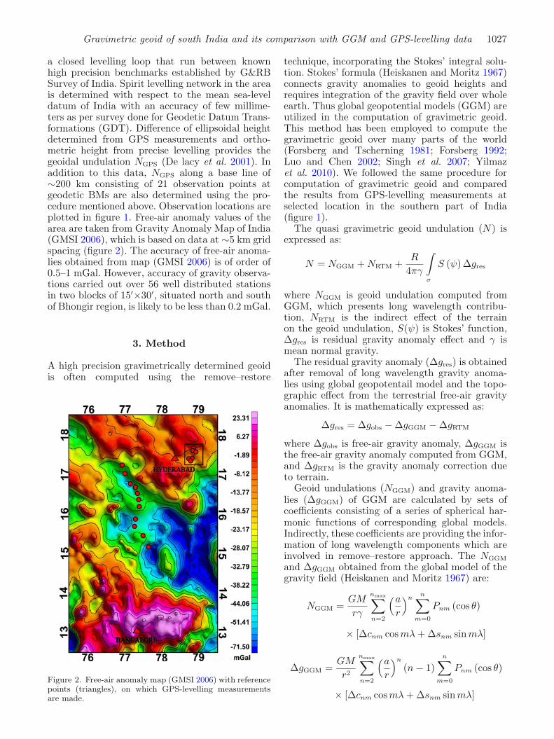
a closed levelling loop that run between knownhigh precision benchmarks established by G&RBSurvey of India. Spirit levelling network in the areais determined with respect to the mean sea-leveldatum of India with an accuracy of few millime-ters as per survey done for Geodetic Datum Trans-formations (GDT). Difference of ellipsoidal heightdetermined from GPS measurements and ortho-metric height from precise levelling provides thegeoidal undulation NGPS (De lacy et al. 2001). Inaddition to this data, NGPS along a base line of∼200 km consisting of 21 observation points atgeodetic BMs are also determined using the pro-cedure mentioned above. Observation locations areplotted in figure 1. Free-air anomaly values of thearea are taken from Gravity Anomaly Map of India(GMSI 2006), which is based on data at ∼5 km gridspacing (figure 2). The accuracy of free-air anoma-lies obtained from map (GMSI 2006) is of order of0.5–1 mGal. However, accuracy of gravity observa-tions carried out over 56 well distributed stationsin two blocks of 15′×30′, situated north and southof Bhongir region, is likely to be less than 0.2 mGal.
3. Method
A high precision gravimetrically determined geoidis often computed using the remove–restore
Figure 2. Free-air anomaly map (GMSI 2006) with referencepoints (triangles), on which GPS-levelling measurementsare made.
technique, incorporating the Stokes’ integral solu-tion. Stokes’ formula (Heiskanen and Moritz 1967)connects gravity anomalies to geoid heights andrequires integration of the gravity field over wholeearth. Thus global geopotential models (GGM) areutilized in the computation of gravimetric geoid.This method has been employed to compute thegravimetric geoid over many parts of the world(Forsberg and Tscherning 1981; Forsberg 1992;Luo and Chen 2002; Singh et al. 2007; Yilmazet al. 2010). We followed the same procedure forcomputation of gravimetric geoid and comparedthe results from GPS-levelling measurements atselected location in the southern part of India(figure 1).
The quasi gravimetric geoid undulation (N) isexpressed as:
N = NGGM + NRTM +R
4πγ
∫
σ
S (ψ) Δgres
where NGGM is geoid undulation computed fromGGM, which presents long wavelength contribu-tion, NRTM is the indirect effect of the terrainon the geoid undulation, S(ψ) is Stokes’ function,Δgres is residual gravity anomaly effect and γ ismean normal gravity.
The residual gravity anomaly (Δgres) is obtainedafter removal of long wavelength gravity anoma-lies using global geopotentail model and the topo-graphic effect from the terrestrial free-air gravityanomalies. It is mathematically expressed as:
Δgres = Δgobs − ΔgGGM − ΔgRTM
where Δgobs is free-air gravity anomaly, ΔgGGM isthe free-air gravity anomaly computed from GGM,and ΔgRTM is the gravity anomaly correction dueto terrain.
Geoid undulations (NGGM) and gravity anoma-lies (ΔgGGM) of GGM are calculated by sets ofcoefficients consisting of a series of spherical har-monic functions of corresponding global models.Indirectly, these coefficients are providing the infor-mation of long wavelength components which areinvolved in remove–restore approach. The NGGM
and ΔgGGM obtained from the global model of thegravity field (Heiskanen and Moritz 1967) are:
NGGM =GM
rγ
nmax∑n=2
(a
r
)nn∑
m=0
Pnm (cos θ)
× [Δcnm cos mλ + Δsnm sinmλ]
ΔgGGM =GM
r2
nmax∑n=2
(a
r
)n
(n − 1)n∑
m=0
Pnm (cos θ)
× [Δcnm cos mλ + Δsnm sinmλ]
1028 N Srinivas et al.
where GM is the geocentric gravitational constantreferring to the total mass (earth’s body plus atmo-sphere), (r, θ, λ) are the spherical polar coordinatesof the computation point (geocentric radius, colat-itudes and longitude, respectively), γ is the meannormal gravity, a is the semi major axis of the ellip-soidal earth model, ΔCnm and ΔSnm are the fullynormalized spherical harmonics coefficient of theGGM, Pnm(cos θ) are the fully normalized associ-ated Legendre polynomials, n and m are the degreeand order of the expansion of global geopotentialmodel.
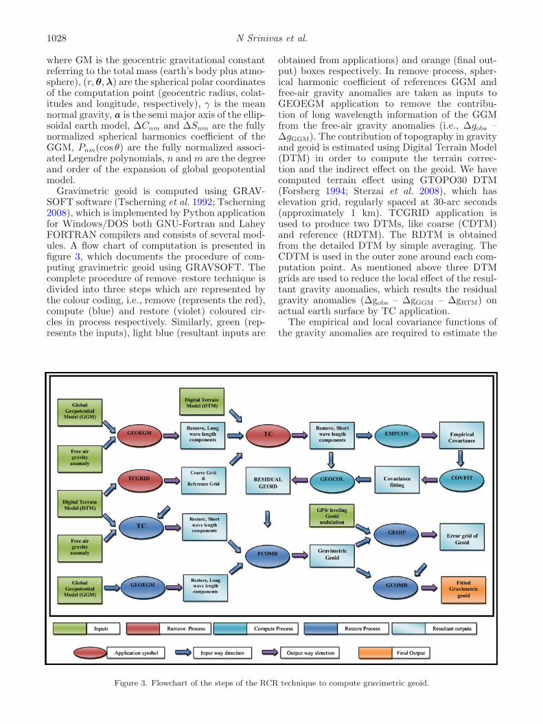
Gravimetric geoid is computed using GRAV-SOFT software (Tscherning et al. 1992; Tscherning2008), which is implemented by Python applicationfor Windows/DOS both GNU-Fortran and LaheyFORTRAN compilers and consists of several mod-ules. A flow chart of computation is presented infigure 3, which documents the procedure of com-puting gravimetric geoid using GRAVSOFT. Thecomplete procedure of remove–restore technique isdivided into three steps which are represented bythe colour coding, i.e., remove (represents the red),compute (blue) and restore (violet) coloured cir-cles in process respectively. Similarly, green (rep-resents the inputs), light blue (resultant inputs are
obtained from applications) and orange (final out-put) boxes respectively. In remove process, spher-ical harmonic coefficient of references GGM andfree-air gravity anomalies are taken as inputs toGEOEGM application to remove the contribu-tion of long wavelength information of the GGMfrom the free-air gravity anomalies (i.e., Δgobs –ΔgGGM). The contribution of topography in gravityand geoid is estimated using Digital Terrain Model(DTM) in order to compute the terrain correc-tion and the indirect effect on the geoid. We havecomputed terrain effect using GTOPO30 DTM(Forsberg 1994; Sterzai et al. 2008), which haselevation grid, regularly spaced at 30-arc seconds(approximately 1 km). TCGRID application isused to produce two DTMs, like coarse (CDTM)and reference (RDTM). The RDTM is obtainedfrom the detailed DTM by simple averaging. TheCDTM is used in the outer zone around each com-putation point. As mentioned above three DTMgrids are used to reduce the local effect of the resul-tant gravity anomalies, which results the residualgravity anomalies (Δgobs – ΔgGGM – ΔgRTM) onactual earth surface by TC application.
The empirical and local covariance functions ofthe gravity anomalies are required to estimate the
Figure 3. Flowchart of the steps of the RCR technique to compute gravimetric geoid.

Gravimetric geoid of south India and its comparison with GGM and GPS-levelling data 1029
residual geoid and these functions are determinedfrom the residual gravity anomalies to estimate thevalues of parameter to build the local covariancemodel. The actual use of covariance fitting involvesa local covariance function which requires the esti-mation of three parameters: the depth of the sphereof Bjerhammar (RB = −0.702 km), the scale fac-tor (AA = 1.01) and the variance of the gravityanomalies at zero height (VARG = 777.89 mgal2).Local covariance model is estimated using EMP-COV and COVFIT applications by the formula(Knudsen 1987) is:
COV (P, Q) = a
Nmax∑n=2
σ2n
(R2
rr1
)n+1
Pn (cos (ψ))
+∞∑
n=Nmax+1
A
Pntype (n)
(R2
B
rr1
)n+1
× Pn (cos (ψ))
where Pn cos(ψ) are the Legendre polynomials, aand A are the scale factor of the error degree vari-ance and scale factor of the degree variance respec-tively, R is the mean radius of the Earth, P andQ with radial distances r and r′, spherical distance(ψ) and σ2
n is error anomaly degree variances of thereference field.
The residual gravity anomalies (Δgres) have beensubsequently converted into residual geoid heights(NRes) by using the fast collocation method withoutcome values like depth of Bjerhammar sphere(RB), VARG and scale factor (AA) which areinputs for GEOCOL application. The gravimetricgeoid (N) was computed using FCOMB applica-tion, by the addition of geoid undulations withcontribution of global geopotential model (NGGM)and residual terrain effects (NRTM) to the residualgeoid undulation (NRES). In the end, geoid heightsof points are obtained by restoring the previousremoved components. The result of the gravimet-ric geoid refers to a global reference system, i.e.,global center of mass, average zero-potential sur-face, etc. Such a geoid may be offset by 1–2 mfrom the apparent geoid heights determined fromGPS on the benchmarks. The reason for the differ-ence is the assumption of zero level. Levelling zerorefers to local or regional mean sea-level, whichis different from the global, zero vertical datumdue to the sea-surface topography. Also, error inlong-wavelength geopotential models, underlyinglocal geoid estimation, may yield offsets of up to1 m or so. In the remove–restore technique, about99% of the geoid heights come from global model.GPS-levelling data is used to resolve the orthome-tric heights in local vertical datum to best fit the
Figure 4. Plots of (a) residual geoid and (b) gravimetric geoid.
1030 N Srinivas et al.
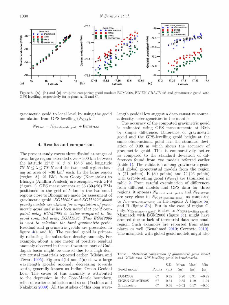
Figure 5. (a), (b) and (c) are plots comparing geoid models: EGM2008, EIGEN-GRACE02S and gravimetric geoid withGPS-levelling, respectively for regions A, B and C.
gravimetric geoid to local level by using the geoidundulation from GPS-levelling (NGPS).
NFitted = NGravimetric geoid + ErrorGrid
4. Results and comparison
The present study covers three dissimilar ranges ofarea; large region extended over ∼300 km betweenthe latitude 12◦.5′ ≤ φ ≤ 18◦.5′ and longitude75◦.5′ ≤ λ ≤ 79◦.5′ and the two small regions hav-ing an area of ∼30 km2 each. In the large region(region A), 21 BMs from Gooty (Karnataka) toBhongir (Andhra Pradesh) are occupied with GPS(figure 1). GPS measurements at 56 (30+26) BMspositioned in the grid of 5 km in the two smallregions close to Bhongir are made for assessment ofgravimetric geoid. EGM2008 and EGM1996 globalgravity models are utilized for computation of gravi-metric geoid and it has been noted that geoid com-puted using EGM2008 is better compared to thegeoid computed using EGM1996. Thus EGM2008is used to calculate the local gravimetric geoid.Residual and gravimetric geoids are presented infigure 4(a and b). The residual geoid is primar-ily reflecting the subsurface density anomaly. Forexample, about a one meter of positive residualanomaly observed in the southwestern part of Cud-dapah basin might be caused due to a high den-sity crustal materials reported earlier (Mishra andTiwari 1995). Figures 4(b) and 5(a) show a largewavelength geoidal anomaly decreasing towardssouth, generally known as Indian Ocean GeoidalLow. The cause of this anomaly is attributedto the depression in the Core-Mantle boundary,relict of earlier subduction and so on (Yoshida andNakakuki 2009). All the studies of this long wave-
length geoidal low suggest a deep causative source,a density heterogeneities in the mantle.
The accuracy of the computed gravimetric geoidis estimated using GPS measurements at BMsby simple difference. Difference of gravimetricgeoid and the GPS-levelling geoid height at thesame observational point has the standard devi-ation of 0.09 m which shows the accuracy ofgravimetric geoid. This is comparatively betteras compared to the standard deviation of dif-ferences found from two models referred earlier(table 1). The validation among gravimetric geoidand global geopotential models from the regionA (21 points), B (30 points) and C (26 points)with GPS-levelling geoid (NGPS) are tabulated intable 2. From careful examination of differencesfrom different models and GPS data for threeregions, it appears N(Gravimetric geoid) and NEGM2008
are very close to N(GPS-levelling geoid) as comparedto N(EIGEN-GRACE02S) in the regions A (figure 5a)and B (figure 5b). But in the case of region C,only N(Gravimetric geoid) is close to N(GPS-levelling geoid).Mismatch with EGM2008 (figure 5c), might havearoused due to lack of terrestrial data over smallregion. Such examples are reported from otherplaces as well (Benahmed 2010; Corchete 2010).The mismatch with global geoid models might also
Table 1. Statistical comparison of gravimetric geoid modeland GGMs with GPS-levelling geoid in benchmarks.
S.D. Mean Maxi Min
Geoid model Points (m) (m) (m) (m)
EGM2008 67 0.42 0.20 0.91 −0.22
EIGEN-GRACE02S 67 0.61 0.35 1.19 −1.04
Gravimetric 67 0.09 −0.02 0.17 −0.36

Gravimetric geoid of south India and its comparison with GGM and GPS-levelling data 1031
Table 2. Comparison of geoid undulation (N) accuracy with respect togeoids model in three dissimilar regions.
Region EGM2008 EIGEN-GRACE02S Gravimetric
(no. of points) rms (m) rms (m) rms (m)
A (21 points) 0.29 0.67 0.12
B (30 points) 0.15 0.2 0.1
C (26 points) 0.73 1 0.1
Figure 6. (a), (b) and (c) Histograms of the differences of NGPS-levelling geoid − NEGM2008, NGPS-levelling geoid −NEIGEN-GRACE02S and NGPS-levelling geoid − NGravimetric for regions A, B and C.
arise due to the fact that their spatial resolutionis limited. The EIGEN-GRACE02S gravity modelis derived solely from GRACE satellite data andreported to have 1 cm accuracy of geoid model witha spectral resolution up to degree and order 150(Reigber et al. 2005). From statistics of the differ-ences in benchmarks between EIGEN-GRACE02Sgeoid model and the GPS-levelling derived geoidheight shows the standard deviation and meanof about 0.61 and 0.35 m, respectively. Similarly,the standard deviation and mean of differencesin EGM2008 geoid model and the GPS-levellinggeoid height are 0.42 and 0.20 m, respectively. TheEGM2008 (Pavlis et al. 2008), provides spherical
harmonic expansion up to degree 2190 and order2159 to compute geoid at any place.
5. Conclusions
Geoid undulations over a part of southern Indianregion are computed from terrestrial gravity data,which allowed investigating the comparison ofgravimetric geoid with geoids from global geopo-tential model and GPS-levelling data. At firstglance, an agreement between GPS-levelling dataand global geopotential model is found on regionalscale (figure 6a and b). However, over small region

1032 N Srinivas et al.
(figure 6c), geoid from GPS-levelling is consider-ably different (in meter). Therefore, it is necessaryto compute gravimetric geoid from terrestrial datato achieve orthometric height in cm accuracy usingGPS. Results of present exercise can be viewed asfollows.
• EGM2008 can provide a transformation platformfrom ellipsoid to local datum. RMS differenceof 0.46 m is observed between EGM2008 andGPS-levelling data and therefore, EGM2008 canbe used in most of the surveys for geophysicalapplications. Nevertheless, a mismatch up to anorder of one meter restricts its use in engineeringapplications.
• Computation of local gravimetric geoid usingexisting gravity data from GMSI 2006 and ele-vation data from GTOPO30 can provide geoidalundulations that can be used to achieve ortho-metric height to the accuracy of about 10 cm(RMS 0.01 m).
Acknowledgements
The authors would like to thank the Director,NGRI for his support and permission to publishthis work. They are also thankful to C C Tscherning,for sharing GRAVSOFT and to Vagner Goncalvesfor fruitful discussions. IFCPAR is acknowledgedfor the financial support provided through aproject on Hydrology and Water Resources fromSpace over Indian region at NGRI.
References
Benahmed D S A 2010 Precision assessment of the ortho-metric heights determination in northern part of Algeriaby combining the GPS data and the local geoid model;Compt. Rendus Geosci. 342 87–94.
Corchete V 2010 The high-resolution gravimetric geoid ofItaly: ITG2009; J. African Earth Sci. 58 580–584.
De lacy M C, Caderot G R, Marin E, Ruiz A, Borque M J,Gil A J and Biagi L 2001 A gravimetric geoid computationand comparison with GPS results in northern andalusia(spain); Studia Geophys. Geod. 45 55–66.
Forsberg R 1992 Modelling the fine-structure of the geoid:Methods, data requirements and some results; Surv.Geophys. 14 403–418.
Forsberg R 1994 Terrain effects in Geoid computations;Lecture notes, School for the Determination and Use ofGeoid, Milano.
Forsberg R and Tscherning C C 1981 The use of height datain gravity field approximation by collocation; J. Geophys.Res. 86 7843–7854.
Gravity Map of Series of India (GMSI) 2006 Grav-ity anomaly maps of India on 1:2 million scale pub-lished by Geological Survey of India; GSI, Hyderabad,India.
Heiskanen W A and Moritz H 1967 Physical geodesy; W HFreeman, San Francisco.
Knudsen P 1987 Estimation and modelling of the localempirical covariance function using gravity data andsatellite altimeter data; J. Geophys. Res. 86 7843–7854.
Luo Z C and Chen Y Q 2002 Precise determination ofHong Kong geoid using heterogeneous data; FIG XXIIInternational Congress, Washington D.C., USA.
Marsh J G 1979 Satellite derived gravity maps; In: A geo-physical atlas for interpretation of satellite derived data,Section 2 (eds) Lowman P D and Fray H V, NASA,Greenbelt, USA.
Mishra D C and Tiwari V M 1995 An asymmetric basiclopolith below sediments in western Cuddapah basin –geophysical evidence; Proceedings of the GeologicalSociety of India; annual convention and seminar on‘Cuddapah basin’, Tirupati, India, pp. 31–41.
Pavlis N K, Holmes S A, Kenyon S C and Factor J K 2008An earth gravitational model to degree 2160: EGM2008;General Assembly of the European Geosciences Union,Vienna, Austria.
Reigber C, Schmidt R, Flechtner F, Konig R, Meyer U,Neumayer K H, Schwintzer P and Zhu S Y 2005 Earthgravity field model complete to degree and order 150from GRACE: EIGEN-GRACE02S; J. Geodyn. 39(1)1–10.
Singh S K, Nagarajan B and Garg P K 2007 Determinationof local gravimetric geoid; Coordinates 3 14–19.
Sterzai P, Coren F, Creati N, Marson N and Maso M2008 An improved geoid in north eastern Italy; Observingour Changing Earth International Association of GeodesySymposia 133(2) 427–430.
Tarial J S 2010 Determination of precise geoid from terres-trial gravity field and its comparison with geoid from gracesatellite gravity mission and global geopotential model ;Project Report, Indian Institute of Survey and Mapping,Hyderabad, India.
Tscherning C C 2008 Geoid determination by 3D least-squares collocation; Draft version.
Tscherning C C, Forsberg R and Knudsen P 1992 Descrip-tion of the GRAVSOFT package for geoid determination;Proceedings of First Continental Workshop on the Geoidin Europe, Prague, pp. 327–334.
Yilmaz I, Yilmaz M, Gullu M and Turgut B 2010 Evalua-tion of recent global geopotential models based on GPS-levelling data over Afyonkarahisar (Turkey); Sci. Res.Essays 5(5) 484–493.
Yoshida M and Nakakuki T 2009 Effects on the long-wavelength geoid anomaly of lateral viscosity variationscaused by stiff subducting slabs, weak plate marginsand lower mantle rheology; Phys. Earth Planet. Int. 172278–288.
MS received 22 June 2011; revised 27 February 2012; accepted 2 March 2012