Grade 9 Geography - Jeopardy ImmigrationLandforms of Canada Settlement Patterns First...
51
Grade 9 Geography - Jeopardy Immigration Landforms of Canada Settlement Patterns First Nations Precipitati on 1 1 1 1 1 2 2 2 2 2 3 3 3 3 3 4 4 4 4 4 5 5 5 5 5
-
date post
21-Dec-2015 -
Category
Documents
-
view
235 -
download
0
Transcript of Grade 9 Geography - Jeopardy ImmigrationLandforms of Canada Settlement Patterns First...
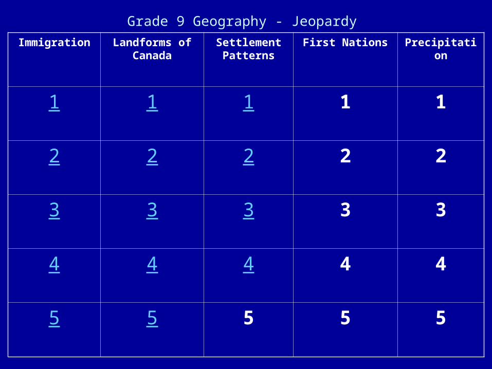
Grade 9 Geography - Jeopardy
Immigration Landforms of Canada
Settlement Patterns
First Nations Precipitation
1 1 1 1 1
2 2 2 2 2
3 3 3 3 3
4 4 4 4 4
5 5 5 5 5

The name for the “Turn of the Century” time period when
the greatest number of immigrants came to Canada .

What is the Great Expansion of
Western Canada OR
the Last Best West?

Job opportunities, peace and security, better
wages, good education and high quality of
health care.

What are Pull Factors?

The three Canadian cities where the majority of
immigrants choose to live.

What are Montreal, Toronto and
Vancouver?
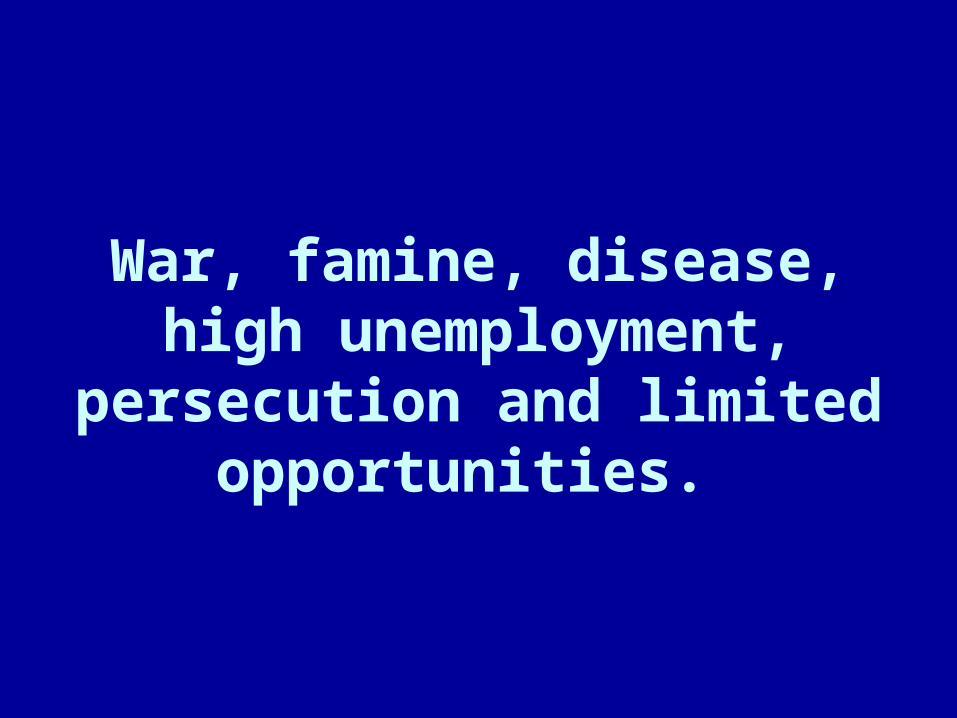
War, famine, disease, high unemployment, persecution and limited opportunities.

What are Push Factors?

The evaluation process used to determine whether or not a
person wishing to come to Canada would likely become
a successful resident of Canada.

What is the Point System?

This landform is composed of two rock types: igneous and
metamorphic.

What is the Canadian Shield?

Kingston is on the eastern edge of one part of this
low-land landform.

What is the Great Lakes-St. Lawrence
Lowland?

Over 50% of Canada’s population live in this
landform.

What is the Great Lakes-St. Lawrence
Lowland?

This landform consists of three mountain ranges
including the Rocky Mountains.

What is the Western Cordillera?

The type of glacier that spreads out to cover a very
large area of land.

What is a Continental Glacier?

In city planning, the nearness to markets, fresh water supplies, transportation
networks, raw materials and power.

What are Location Factors?

The pattern showing where people live in a certain area.

What is Population Distribution?

Low density development around a city

What is Urban Sprawl?

The number of customers needed to make a business
profitable OR allow a service such as a school to
be offered.
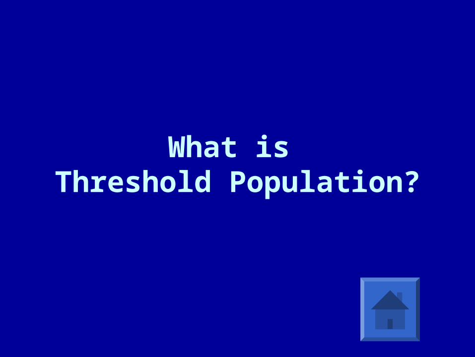
What is Threshold Population?

The process of changing from rural to urban.

What is Urbanization?

A Native group in which the members share a common
culture and history.

What is a First Nation?

Used by the British government to obtain land, it
is an area of land set aside for Status Indians.

What is a Reserve?
Special schools where First Nation children were sent “to save them from themselves”
and the children were not permitted to speak their
Native language or practice Nature culture.

What are Residential Schools?
The 1876 law that allowed the Canadian government to sign
treaties with First Nation groups so the First Nation
people would surrender claims to the land.

What is the Indian Act?
Canada’s newest territory

What is Nunavut?
Orographic OR
Relief Precipitation.

What is the type of precipitation that occurs when warm moist air is forced to rise over large
mountains?

This type of precipitation occurs when a cold air mass
meets a warm air mass.
What is Frontal or Cyclonic
Precipitation?

Unimpeded, fast-flowing air (up to 500 km/hr)
moving west to east at a very high altitude (8 000 -15 000 m).

What is the Jet Stream?

This precipitation occurs when air is heated over warm land resulting in the air rising

What isConvection Precipitation?

This leading edge of warm air.

What is a Warm Front?