GPS NETWORK FOR LOCAL DEFORMATION … GPS NETWORK FOR LOCAL DEFORMATION MONITORING IN THE ATLAS...
8
1 GPS NETWORK FOR LOCAL DEFORMATION MONITORING IN THE ATLAS MOUNTAINS OF MOROCCO A.J. GIL 1 , M.C. DE LACY 1 , A.M. RUIZ 1 , J. GALINDO-ZALDÍVAR 2 , P. AYARZA 3 A. TEIXELL 4 , F. ALVAREZ-LOBATO 3 , M.L. ARBOLEYA 4 , A. KCHIKACH 5 M. AMRHAR 5 , M. CHARROUD 6 , R. CARBONELL 7 and E. TESÓN 4 1 Departamento de Ingeniería Cartográfica, Geodesia y Fotogrametría Universidad de Jaén. Spain 2 Departamento de Geodinámica, Universidad de Granada. Spain 3 Departamento de Geología, Facultad de Ciencias, Universidad de Salamanca, Spain 4 Departament de Geologia, Universitat Autònoma de Barcelona, Bellaterra, 08193, Spain 5 Faculté des Sciences et Techniques, Université Cadi-Ayyad, BP549, Marrakech, Morocco 6 Département de Géologie, Faculté des Sciences et Techniques Fès-Saïss, Université Sidi Mohammed Ben Abdellah, BP 2202, Fes, Morocco 7 Instituto de Ciencias de la Tierra ‘Jaume Almera’, CSIC, Barcelona, 08028 Abstract: The Atlas Mountains of Morocco have been the target of several geophysical studies: gravity, refraction and MT surveys carried out during the 80’s and 90’s have helped to establish some of the main characteristics of this intracontinental orogen, such as its overall structure and modest crustal thickness. Later studies, based on structural geology, higher resolution gravity surveying and multidisciplinary potential field modelling indicated that the High Atlas crust is too thin to support its topography and that a mantle contribution is required. An astenospheric upwelling, which triggered the Eocene-to-recent Atlas magmatic activity was then proposed as the main cause of its topography. Crustal thickness happens to be the key to establish the position of the lithosphere-astenosphere boundary and therefore, to asses the real contribution of the mantle to the topography and accordingly the actual uplift. In the frame of a multidisciplinary project covering the described issues, a non-permanent GPS network have been established around the Ouarzazate Basin and surveyed for the first time in September 2007. This network is aimed to control the recent vertical and horizontal movements that affect the area in an attempt to constrain the current deformation rates in the Atlas system.
Transcript of GPS NETWORK FOR LOCAL DEFORMATION … GPS NETWORK FOR LOCAL DEFORMATION MONITORING IN THE ATLAS...

1
GPS NETWORK FOR LOCAL DEFORMATION MONITORING IN THE ATLAS MOUNTAINS OF MOROCCO
A.J. GIL1, M.C. DE LACY1, A.M. RUIZ1, J. GALINDO-ZALDÍVAR2, P. AYARZA3 A. TEIXELL4, F. ALVAREZ-LOBATO3, M.L. ARBOLEYA4, A. KCHIKACH5
M. AMRHAR5, M. CHARROUD6, R. CARBONELL7 and E. TESÓN4
1 Departamento de Ingeniería Cartográfica, Geodesia y Fotogrametría Universidad de Jaén. Spain
2Departamento de Geodinámica, Universidad de Granada. Spain 3Departamento de Geología, Facultad de Ciencias, Universidad de Salamanca, Spain
4Departament de Geologia, Universitat Autònoma de Barcelona, Bellaterra, 08193, Spain 5Faculté des Sciences et Techniques, Université Cadi-Ayyad, BP549, Marrakech, Morocco
6Département de Géologie, Faculté des Sciences et Techniques Fès-Saïss, Université Sidi Mohammed Ben Abdellah, BP 2202, Fes, Morocco
7Instituto de Ciencias de la Tierra ‘Jaume Almera’, CSIC, Barcelona, 08028
Abstract: The Atlas Mountains of Morocco have been the target of several geophysical studies: gravity, refraction and MT surveys carried out during the 80’s and 90’s have helped to establish some of the main characteristics of this intracontinental orogen, such as its overall structure and modest crustal thickness. Later studies, based on structural geology, higher resolution gravity surveying and multidisciplinary potential field modelling indicated that the High Atlas crust is too thin to support its topography and that a mantle contribution is required. An astenospheric upwelling, which triggered the Eocene-to-recent Atlas magmatic activity was then proposed as the main cause of its topography. Crustal thickness happens to be the key to establish the position of the lithosphere-astenosphere boundary and therefore, to asses the real contribution of the mantle to the topography and accordingly the actual uplift. In the frame of a multidisciplinary project covering the described issues, a non-permanent GPS network have been established around the Ouarzazate Basin and surveyed for the first time in September 2007. This network is aimed to control the recent vertical and horizontal movements that affect the area in an attempt to constrain the current deformation rates in the Atlas system.
2
1. INTRODUCTION
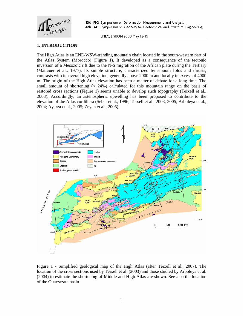
The High Atlas is an ENE-WSW-trending mountain chain located in the south-western part of the Atlas System (Morocco) (Figure 1). It developed as a consequence of the tectonic inversion of a Mesozoic rift due to the N-S migration of the African plate during the Tertiary (Mattauer et al., 1977). Its simple structure, characterized by smooth folds and thrusts, contrasts with its overall high elevation, generally above 2000 m and locally in excess of 4000 m. The origin of the High Atlas elevation has been a matter of debate for a long time. The small amount of shortening (< 24%) calculated for this mountain range on the basis of restored cross sections (Figure 1) seems unable to develop such topography (Teixell et al., 2003). Accordingly, an astenospheric upwelling has been proposed to contribute to the elevation of the Atlas cordillera (Seber et al., 1996; Teixell et al., 2003, 2005, Arboleya et al., 2004; Ayarza et al., 2005; Zeyen et al., 2005).
Figure 1 - Simplified geological map of the High Atlas (after Teixell et al., 2007). The location of the cross sections used by Teixell et al. (2003) and those studied by Arboleya et al. (2004) to estimate the shortening of Middle and High Atlas are shown. See also the location of the Ouarzazate basin.
3
The Ouarzazate basin is the best preserved foreland basin developed adjacent to the High Atlas and contains the best record of syn-orogenic sediments. It is bounded to the N by the south Atlas thrust front, which concentrates most of the deformation and shortening affecting the High Atlas. This thrust system, probably active from the Oligocene to the Quaternary, affects sediments from the Triasic to the Upper Eocene. The shortening ratio in this area has been calculated after detailed tectonic follow up and cross section restoration and has proven to be slow: 0.3 mm/year (Tesón and Teixell, 2006). However, this is an average velocity calculated from the Oligocene, and shortening velocities might be higher in some periods of time.
The asthenospheric upwelling affecting the High Atlas might respond for as much as 50% of its present day elevation (Teixell et al., 2005, 2007). This uplift may have been, however, partly compensated by flexural subsidence linked to the thrust load and led to the scarce development of foreland basins (Garcia-Castellanos et al., 2007). The age of this uplift is controversial. Geomorphologic evidences related with the present day elevation of undeformed marine and lacustrine sediments suggest that the mantle related uplift might have started 5 Ma ago (Babault et al., in press). That leads to an uplift rate of 0.2 mm/year on average, although again, this is an average and might have reached temporally higher values.
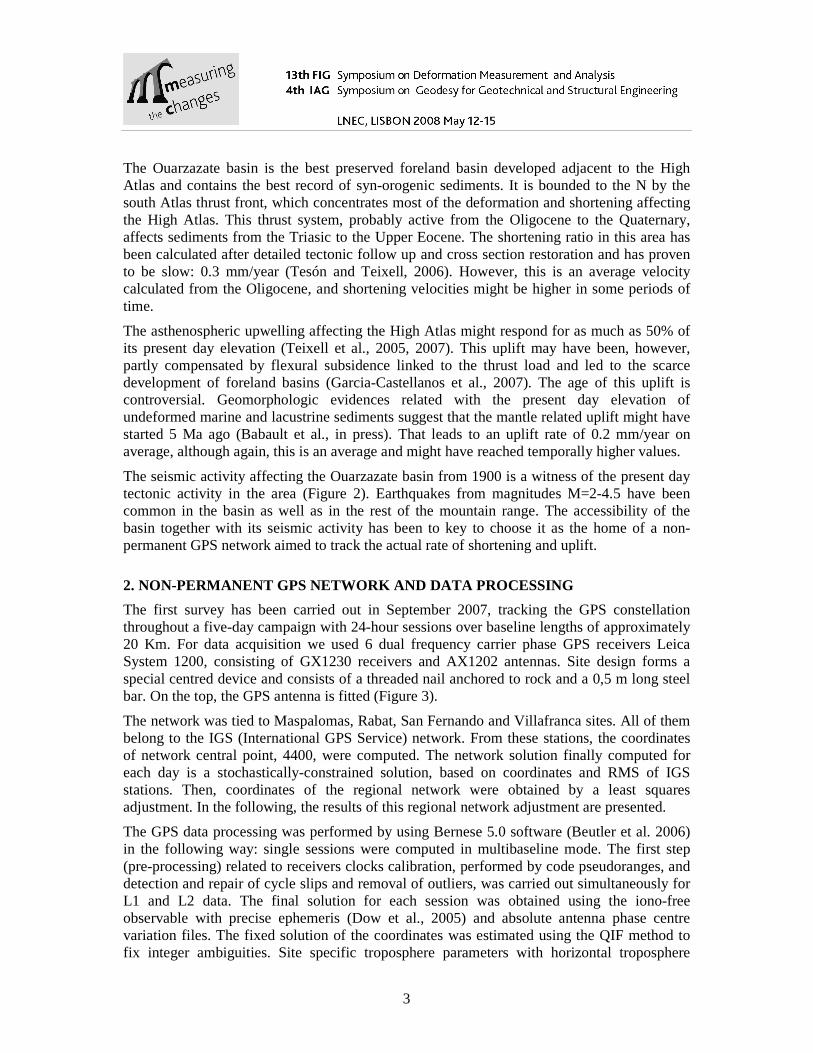
The seismic activity affecting the Ouarzazate basin from 1900 is a witness of the present day tectonic activity in the area (Figure 2). Earthquakes from magnitudes M=2-4.5 have been common in the basin as well as in the rest of the mountain range. The accessibility of the basin together with its seismic activity has been to key to choose it as the home of a non-permanent GPS network aimed to track the actual rate of shortening and uplift.
2. NON-PERMANENT GPS NETWORK AND DATA PROCESSING
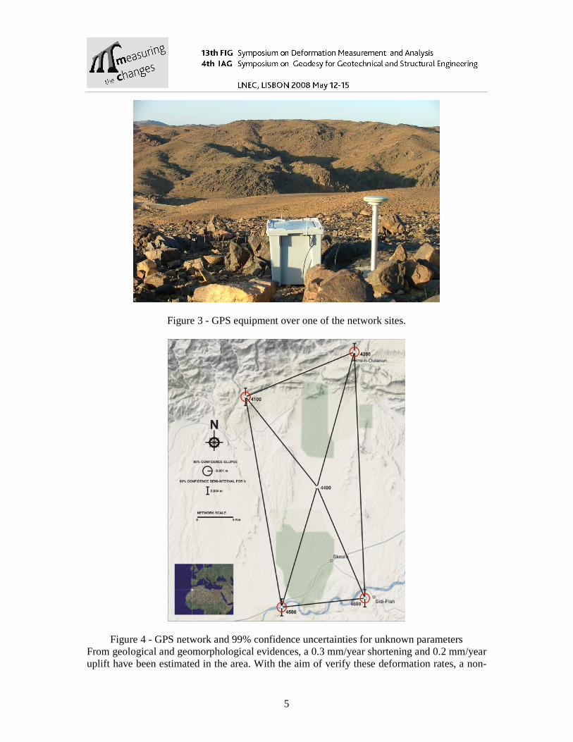
The first survey has been carried out in September 2007, tracking the GPS constellation throughout a five-day campaign with 24-hour sessions over baseline lengths of approximately 20 Km. For data acquisition we used 6 dual frequency carrier phase GPS receivers Leica System 1200, consisting of GX1230 receivers and AX1202 antennas. Site design forms a special centred device and consists of a threaded nail anchored to rock and a 0,5 m long steel bar. On the top, the GPS antenna is fitted (Figure 3).
The network was tied to Maspalomas, Rabat, San Fernando and Villafranca sites. All of them belong to the IGS (International GPS Service) network. From these stations, the coordinates of network central point, 4400, were computed. The network solution finally computed for each day is a stochastically-constrained solution, based on coordinates and RMS of IGS stations. Then, coordinates of the regional network were obtained by a least squares adjustment. In the following, the results of this regional network adjustment are presented.
The GPS data processing was performed by using Bernese 5.0 software (Beutler et al. 2006) in the following way: single sessions were computed in multibaseline mode. The first step (pre-processing) related to receivers clocks calibration, performed by code pseudoranges, and detection and repair of cycle slips and removal of outliers, was carried out simultaneously for L1 and L2 data. The final solution for each session was obtained using the iono-free observable with precise ephemeris (Dow et al., 2005) and absolute antenna phase centre variation files. The fixed solution of the coordinates was estimated using the QIF method to fix integer ambiguities. Site specific troposphere parameters with horizontal troposphere
4
gradients were estimated for all but the central station. From these results we used an intermediate program to produce GPS baselines with their covariance matrixes. Using the NETGPS software (Crespi, 1996) that performs the adjustment of GPS baselines accounting for their full covariance matrixes, a minimal-constrained network adjustment was done.
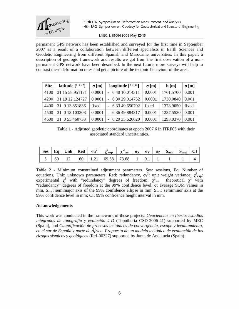
Table 1 shows the adjusted geodetic coordinates at epoch 2007.6 in ITRF05 and Table 2, the minimum constrained adjustment parameters. 99% confidence regions and height confidence intervals are drawn in Figure 4.
Figure 2- Topographic map of the Ouarzazate basin with the location of earthquake epicentres occurred from 1900 to 2007, as recorded by the Spanish Geographical Institute (black dots). These earthquakes have magnitudes M<4.7 and the size of the dot is related with the size of the earthquake. See also de location of the non-permanent GPS stations (red crosses).
3. CONCLUSION
The High Atlas is an ENE-WSW-trending mountain chain located in the south-western part of the Atlas System (Morocco). An astenospheric upwelling has been proposed to contribute to the elevation of the Atlas cordillera. The Ouarzazate basin is the best preserved foreland basin developed adjacent to the High Atlas and contains the best record of syn-orogenic sediments.
5
Figure 3 - GPS equipment over one of the network sites.
Figure 4 - GPS network and 99% confidence uncertainties for unknown parameters From geological and geomorphological evidences, a 0.3 mm/year shortening and 0.2 mm/year uplift have been estimated in the area. With the aim of verify these deformation rates, a non-
6
permanent GPS network has been established and surveyed for the first time in September 2007 as a result of a collaboration between different specialists in Earth Sciences and Geodetic Engineering from different Spanish and Marocaine universities. In this paper, a description of geologic framework and results we got from the first observation of a non-permanent GPS network have been described. In the next future, more surveys will help to contrast these deformation rates and get a picture of the tectonic behaviour of the area.
Site latitude [º ‘ ‘’] σ [m] longitude [º ‘ ‘’] σ [m] h [m] σ [m]
4100 31 15 58.951171 0.0001 - 6 40 10.014311 0.0001 1761,5700 0.001
4200 31 19 12.124727 0.0001 - 6 30 29.014752 0.0001 1730,0840 0.001
4400 31 9 13.851836 fixed - 6 33 49.650702 fixed 1378,9050 fixed
4500 31 0 13.103308 0.0001 - 6 36 49.884317 0.0001 1237,5530 0.001
4600 31 0 55.460733 0.0001 - 6 29 35.626620 0.0001 1293,0370 0.001
Table 1 - Adjusted geodetic coordinates at epoch 2007.6 in ITRF05 with their associated standard uncertainties.
Ses Eq Unk Red σ 02 χ
2exp χ
2teo σX σY σZ Smin Smaj CI
5 60 12 60 1.21 69.58 73.68 1 0.1 1 1 1 4 Table 2 - Minimum constrained adjustment parameters. Ses: sessions, Eq: Number of equations, Unk: unknown parameters, Red: redundancy, σ0
2: unit weight variance; χ2exp:
experimental χ2 with “redundancy” degrees of freedom; χ2teo theoretical χ2 with
“redundancy” degrees of freedom at the 99% confidence level; σ: average SQM values in mm, Smaj: semimajor axis of the 99% confidence ellipse in mm. Smin: semiminor axis at the 99% confidence level in mm; CI: 99% confidence height interval in mm. Acknowledgements This work was conducted in the framework of these projects: Geociencias en Iberia: estudios integrados de topografía y evolución 4-D (Topoiberia CSD-2006-41) supported by MEC (Spain), and Cuantificación de procesos tectónicos de convergencia, escape y levantamiento, en el sur de España y norte de África. Propuesta de un modelo tectónico de evaluación de los riesgos sísmicos y geológicos (Ref-00327) supported by Junta de Andalucía (Spain).

7
References Arboleya, M.L., Teixell, A., Charroud, M. y Julivert, M. (2004). A structural transect through the High and Middle Atlas of Morocco. Journal of African Earth Sciences, 39, 319-327. Ayarza, P., Alvarez-Lobato, F., Teixell, A., Arboleya, M.L.. Teson, E., Julivert, M. y Charroud, M. (2005). Crustal structure under the central High Atlas Mountains (Morocco) from geological and gravity data. Tectonophysics, 400: 67. Babault, J., Teixell, A., Arboleya, M.L. y Charroud, M (2008, in press) Geological evidence for long-wavelength surface uplift of the Atlas Mountains of Morocco. Terra Nova. Beutler G., Bock H., Brockmann E., Dach R., Fridez P., Gurtner W., Habrich H., Hugentobler U., Ineichen D., Jaeggi A., Meindl M., Mervart L., Rothacher M., Schaer S., Schmid R., Springer T., Steigenberger P., Svehla D., Thaller D., Urschl C. and Weber R. (2006) BERNESE GPS software version 5.0. Astronomical Institute, University of Berna. Crespi, M. (1996) Software Package for the Adjustment and the Analysis of GPS Control Network.Reports on Survey and Geodesy in memoria Prpff. Gubellini and G. Folloni. Edizione Nautilus, Bologna, 237-264. Dow J.M, Neilan R.E. and Gendt G. (2005) The International GPS Service (IGS): Celebrating the 10th Anniversary and Looking to the Next Decade, Adv. Space Res. 36, 3,320-326 doi:10.1016/j.asr.2005.05.125 García-Castellanos, D., Jiménez-Munt, I., Teixell, A.. Fernàndez, M., Arboleya, M.L., y Vergés, J. (2007). Numerical modelling constraints on the uplift of the Atlas mountains in Morocco. 1st MAPG International Convention-3rd meeting of the ILP task force Sedimentary Basins: The Geology of Vertical Movements, Abstract Book, Marrakech, p. 24. Mattauer, M., Tapponier, P. y Proust, F. (1977). Sur le mécanismes de formation des chaines intracontinentales : L’exemple des chaines atlasiques du Maroc. Bulletin Societé Géologique de France, 19: 521-526. Seber, D., M. Barazangi, B.A. Tadili, M. Ramdani, A. Ibenbrahim y Ben Sari, D. (1996). Three dimensional upper mantle structure beneath the intraplate Atlas and interplate Rif mountains of Morocco. Journal of Geophysical Research, 101: 3125-3138. Teixell, A., Arboleya, M.L., Julivert, M. y Charroud, M. (2003). Tectonic shortening and topography in the central High Atlas (Morocco). Tectonics, 22: 1051, doi: 10.1029. 2002TC001460. Teixell, A., Ayarza, P., Zeyen, H., Fernandez, M. y Arboleya. M.L. (2005). Effects of mantle upwelling in a compressional setting: the Atlas Mountains of Morocco. Terra Nova, 17, 456-461.
8
Teixell, A., Ayarza, P., Tesón, E., Babault, J. Alvarez-Lobato, F. Charroud, M. Julivert, M., Barbero, L.. Amrhar, M., and Arboleya, M.L. (2007). Geodinámica de las cordilleras del Alto y Medio Atlas: Síntesis de los conocimientos actuales. Revista de la Sociedad Geológica Española, 20 (3-4), 119-135. Tesón, E. y Teixell, A. (2006): Sequence of thrusting and syntectonic sedimentation in the eastern Sub-Atlas thrust belt (Dadès and Mgoun valleys, Morocco). International Journal of Earth Sciences, doi: 10.1007/s00531-006-0151. Zeyen, H., Ayarza, P., Fernàndez, M. y Rimi, A. (2005). Lithospheric structure under the western African-European plate boundary: a transect across the Atlas Mountains and the Gulf of Cadiz. Tectonics, 24, TC2001, doi:10.1029, 2004TC001639. Corresponding author contacts Antonio J. GIL
[email protected] Departamento de Ingeniería Cartográfica, Geodesia y Fotogrametría, Universidad de Jaén Spain
M.C. DE LACY: [email protected] A.M. RUIZ: [email protected] J. GALINDO-ZALDÍVAR: [email protected]


![Arc parallel shear deformation and escape flow in the ...as GPS deformation measurements or temperature and flow modeling at depth. [10] Based on the joint consideration of the results](https://static.fdocuments.in/doc/165x107/5e9a6f2ecf9782594a446f6b/arc-parallel-shear-deformation-and-escape-flow-in-the-as-gps-deformation-measurements.jpg)