Directorate Office Directorate of Education (Govt. of NCT ...

GOVERNMENT OF ODISHA
DIRECTORATE OF GEOLOGYBHU-BIGYAN BHAWAN, BHUBANESWAR-751 001
Phone: +91 674 2392 374 ; Fax:91 674 2391 776 ; E-mail: [email protected]
No. GXV(g)- 196/15 ___'From
DG Dt: 05.08.2015
SKSahuDeputy Director Geology & Authorised OfficerDirectorate of Geology, OdishaBhubaneswar- 751001
ToThe TahasildarNimapara Tahsil,District: Puri
Sub: Approval of Mining Plan in respect of Kushabhadra river sand quarry over an area of 16.00acres or 6.47 hect in ViII: Dhirapur, Dighalo & Garh Tusing under Nimapara Tahsil of PuriDistrict
Sir,
In exercise ofpowers conferred by the Clause4 and Rule 27 A of OMMC (Ammendment,Rules 2014 vide notification S.R.Ono.443/2014, Dt 16.09.2014 and no.7293/SM Dt 25.09.2014 ofSteel & Mines Department ,Govt. of Odisha & MM (Meetingj-25/2013-37606/RDM, BBSR,Dt10.12.2014 of R &DM Dept. The Mining Plan submitted by Sri Sujit Kumar Mohanty Regd No.RQP/GOA/204/2010/A concerning the above cited and applied quarry lease is hereby approved forfive years i.e. 2015-16 to 2019-2020 basing on the auction made by Tahasildar subject to thefollowing conditions:
1. The Mining Plan is approved without prejudice to any other law applied to the lease areafrom time to time whether made by the Central! State Govt/ any other authority.
2. .The Mining Plan is approved without prejudice to any other order or direction from thecourt of competent jurisdiction.
3. The approval of the said Mining Plan does not in any way imply the approval of the Govt interms of any other provisions und~~MC (amendment, rules 2~14j or any other law.
4. The sand quarry operation should be done below Water table."-"'____---
Two copies of the approved Mining Plan'are enclosed her with for further action at your end. it .
Yours faithfully,
~Jt.---~SK s.clhu
Deputy Director GeOlogy&62. 11" Authorised OfficerMemo No. .....'. ViDG Dt: 05;08.2015
Copy forwarded toVs KMohantv, RQP,3M3E Global,.1789/19 Nuasahi, Navapalli, BBSR-751012,Odisha / Sri Binod Kumar Pradhan, Lessee At- Barimundei, PS-Bal.anga,Dist- Puri, Odisha for
---.~¥$1<~4~\information and necessaryaction.
Deputy Director Geology&Authorised Officer
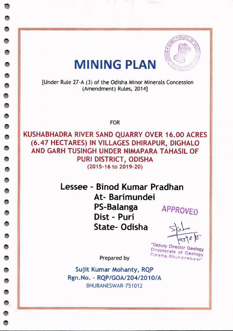
MINING PLAN[Under Rule 27-A (3) of the Odisha Minor Minerals Concession
(Amendment) Rules, 2014]
KUSHABHADRA RIVERSANDQUARRY OVER 16.00 ACRES(6.47 HECTARES) IN VILLAGES DHIRAPUR, DIGHALOAND GARH TUSINGH UNDER NIMAPARA TAHASIL OF
PURl DISTRICT, ODISHA(2015-16 to 2019-20)
Lessee - Binod Kumar PradhanAt- BarimundeiPS-BalangaDist - PuriState- Odisha
FOR
Prepared by
APPROVED
~\~~¥~"D ..eputy Director Geo]DIrectorate of G ogyOd· . eo logyIsha, 8hub~~.neswar"
Sujit Kumar Mohanty, RQPRgn.No. - RQP/GOA/204/2010/A
BHUBANESWAR-751012

CGNTENTS I
, , ,
SI. No. Title 1
Page1 Consent letter from Lessee ! I2 Certificate from RQP I
II
"I1---- --'-'-----~--,---,-,-+-~-,,----,------_.__ .._ ------.~-.-------.- ..-. ---3 Copy of RQPCertificate from! IBM ... I"I I-'--_._------- r--------1------. -.--------14 Certificate and Undertaking IV\-. _ .._-----_._-__ ._------- . -----5 Introduction 1 I
I --11---
6 Mining Plan in prescribed Form-ZB 37 Annexure j
I~8 Plates _J

List of 'AnnexureTitle No. I
ICopy of Tahasildar letter along- Iwith Land Schedule __JFeasibility Report of Revenue II
~
Inspector and LandSchedule ':
Declaration by Lessee and R.I. on III Ipillar posting on lease boundary--~Identity & Addressproofs of Lessee IV iCopyof RoR V---___ .____~___I

tntroduction:
Featured in Survey of India Toposheet No F45U4,
Kushabhadra River Sand quarry is an old Sairat sourceauctioned for long-term (5 years) lease with effect from
2015-16 to 2019-20 by the Tahasildar, Nimapara through
competitive bidding process. The prospective lessee Sri
Binod kumar Pradhan, being the highest bidder, has been
selected by the Tahasildar for operating the source after
completing all the formalities required as per existingrules.
This deposit is located at a distance of 3km from Nimapara
on river Kushabhadra. The operation of this deposit shall
fall within the administrative control of Tahasildar,Nimapara under Puri district.
Lease area over 16.00 acres is well connected to Tahasil
Headquarters Nimapara (3 km) and Pipili (23 km) on Pipili
Konark road. River Kushabhadraflows from north to southalong this section.
Keeping the deposit and its resource in view an attempt
has been made to prepare a sustainable plan for mining
with production schedule for coming five years. Theaverage annual production has been fixed at 4725 m3
considering a thickness of 1.50 m. _ __ ~~ ~,~."D t:::-....· t~epu Y orr or Geology
This Plan has been prepared basedon the precis~ja:naarmGp>fGeologyOd j s ha, 8 h u ba n eswa r"(Lease Plan) provided by the concerned Revenue Inspector
of Nimapara Tahasil and information COllecte~.duri~ ""
. 1 SUJltkUI.:'d"',RQP/GOAl204/2010fA

survery.
in future for various reasons including requirement for
scientific mining and protection of environment as per the
provisions provided in the OMMC(Amendment) Rules, 2014.
-~~'
·Deput~~~~I;gyDirectorate of Geology·r-. ,.j i Q ha , R h l!h :"1 n e s w ~. "
2
.... ":".1.
FORM-ZB
[See Rule 27-A (3) of the Odisha Minor Minerals Concession(Amendment) Rules, 2014]
MINING PLAN FORWiNNING OF RIVERSAND FROM DHIRAPUR,DIGHALO AND GARH TUSINGH VILLAGE UNDERTERUNDIA
PANCHAYAT, NIMAPARA TAHASIL OF PURl DISTRICT
(Category: B2)
1. Name & Address of the Lessee I Binod Kumar Pradhan
At- Barimundei
I PS-BalangaI Dist - PuriI State- Odisha
iKhata No. Plot No. j
326 8, 117 I414 248 j
ilocation map and surface plan Garh Tusingh 158 410 Ishowing the existing features of (NB: All the above four plots are Ithe area with contours at 2 m part plots) Iinterval) I Villages - Dhirapur, Dighato and i
I
APPROV~DArea- 16.00 acres '*, '(Location Map - Plate 11'0Ilny Ire ~ nu
Oirectora or ed,ogy• Tope-sheet - F45!:Jdisha stile °b'lGeology
, u alnesw~r"Co-ordinates I
j
Dhirapur: . _ _j'------------------'-3----- Sujit K~hanty
RQP/GOAl204/2010/A
2. Particulars of the
l---1
Ii
Ii
Area Mouza
(Acreage, Boundary Description Dhirapur
& Land Schedule): (Attach Dighalo
Garh Tusingh
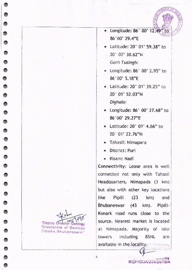
._----------,• Latitude: 20° 01' 59.38" to
20° 02' 30.62"N
Garb Tus;ngh:
• Longitude: 86c 00' 2.95" to86000' 5.18"E
IConnectivity: Lease area is well jI
connected not only with Tahasil IHeadquarters, Nimapada (3 krn) I
I
but also with other key locations II
and Ii
Pipili- II
~ I Konark road runs dose to the I
UD ~ n~ 'I·source. Nearest market is located Ieputy Dir ctor Geology I I
IDirectorate of Geolo~W I at Nirnapada. Majority of tete IOdlsha,8hubanesws'rn ! I
I I towers including BSNL are I
lavailable in the-,):6'c'~[ity~0- .' ,,"..,~',,~.II ~ \ rJ r: ~ I' 1______________________ ~ ~_:~; ,1 ,,1,0 I
4 ' '.Y... _. ~...,•...;...,1..RQP/GOAi204/20 1O/A
• Latitude: 200 01' 39.25" to200 01' 52.03"N
Dighalo:
• Longitude: 86° 00' 27.68" to86°00' 29.27"E
• Latitude: 20° 01' 4.66" to200 01' 22.76"N
• Tahasil: Nimapara
• District: Puri
• Kisam: Nadi
like Pipili (23
(43
km)
km).Bhubaneswar
-------------_._-----,---------- ---------_ .._----------------------
3.Status of the Lessee (Private Private Individual
individual/ Private Company/ IiI
Five years, from 2015-16 to 2019~
20 II I
5. Mineral intended to be won I River sand ----------~!I I
6. Name, Addr~si~e~ratio~lsu'tKumarM~nt;~------~
No. of RQP preparing the mining A/40, Nilakantha Nagar, Nayapalli,
plan with validity of IBhubaneswar-751012 IRecognition I Registration No.- I
I RQP/GOA/204/20101 A IValid upto- 21st October 2020 III
IOdisha, India
7. Order No. & date of I Letter no. 30271 Dtd. 17.6.2015 ofj
Competent Authority granting I Tahasildar, Nimapara Ithe concession I (Copy attached: Annexure-I) I(copy of the Order to be I I
II
8. If, forest area, whether forest No forest land is involved-~~~e::f]f'
I__ ~1~
clearance obtained (Attached °Deputy Director- ~eologyDirectorate of ~eo'oqyo r:i! Sh a, 8 h ub a nle S ltV.., r "
I
Public Sector Undertaking I Joint
Sector Undertaking! Others)
4. Period -of Concession
attached)
copy of forest clearance)
II
L________ ------' ,
Sujit KU~~hantYRQP/GOAl204/2010/A
5

9. Reserve (Estimation to be 'The river sand
based on the exploration, if any, derived from hard rock due toIcarried out in the area or on weathering, erosionand long term I
local parameters) transportation. Size of the sand
grain is small and shape is mostly
rounded because of long II
transportation from the source. IThese deposits are renewable I
I unlike other mineral deposits. It isI mostly difficult to assess the Ideposit of a specific stretch with I
I certainty as every year sand gets
I depositedthere in variouspatches
I along the river course. Unlike
I other mineral resources sand isformed and gets deposited
through majorly physical action.
However,the assessmenthasbeen
made basedon prevailing surface II
conditions. IThe resource/ reserve has been Iestimated based on surface area
method taking average thickness
i~~edepo:~ __ ~~.
" . ',"_i ,-, , \ ~ •• _..-.... .-. c,'
6

Block Surfacearea of Averageth
sand (rn") of sandA B
1 27821 1.5
I 2 5483 1.5~ =r---3 10682 1.5t-------- --------- -------
Total--
GEOLOGICALRESERVE-----,----------,---
41731.5
ickness Volumeof sand(m) (rn3)~~-+-----------~
C=A X B
,-----+---------18224.5 I
------+----16-023~
----6"5-979-1
PROVEO
Mineable reserve, as furnished below, hasbeen calculated by excluding
the reserve locked ill 7.5m safety zone from the geological reserve.r---r--------------M--IN-E-A-S-l-E--R-E-SE-R-V-E--------- -----TlY-----,r----~--=r"-~~~~---r---~~-~__,_=~-~-~~~~i JBlock Surface I I
area of Averagethickness I' Volumeof sand 1
sand (m'') of sand (m) (m3) cateogory_j'A B C=A X B
1---1-+---9-5-1-5----f-----1-.-5 ----+--14272.5 --12 1241 1.5 1861.s-~· 'I
~ PROVED3 5019 1.5 --t 7528.5 i I
I--_~ ~ ~i' ----- ITotal !I 23662.5 i
I~-------- ------ L_ _ __'
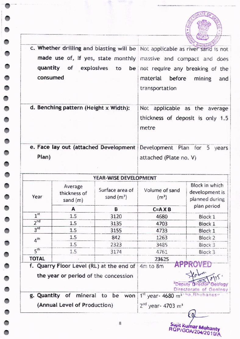
10. Miningi----------::-:-:::------:---------------------- -t-----:------------
a. Whether manual or semi- Manual
mechanized or mechanized
b. If semi-mechanized or mechanized, Not Applicable
number, type and capacity of Imachines to be used I I
L---- L _
SujitKu2:::antvRQP/GOAl204/2010/A
7
mining
quantity of _explosives
consumed
not
material
I transportation
d. Benching pattern (Height x Width): ~[ applicable as the average
thickness of deposit is only 1.5 II metre- t Ie. Face layout (attached Development Development -Plan for - 5yea-rsl
Plan) attached (Plate no. V)II Ih------------------------- ~ __
YEAR-WISE DEVELOPMENT IIAverage I I -----T~BIOCk i~hich II
I Surface area of I, Volume of sand development is Ithickness ofYear sand (m) sand (m2) (m") I planned during i
11-__ -;------1I-- A -+ ~ r C=A X B I.~~~".':'~~~I1" 1.5 3120 4680, Block1..
112'd 1.5 3135 4703 I Block1-11
1----3...,-,;rd,---+---1-.5----+I----__--3-15--5--- 4733 --I__~~ck _1__ ____, "
1.5 842 1263 1-- Block 2 'I' ,_
4th --+__r--- i ---------------1---------------------------- ----t-----------------------------------j
1.5 2323 J 3425 i Block:3 i1----5-;-;th;------1~---1--.5------- --- 3174-----1-------4"1 6i---------i-------B-iO~k-3----- ---I
TOTAL t----------t--------- 2362S-----l----------- -----1,f. Quarry Floor Level (RT) at the end of i 4rrl to 8m-----A-pp-ROVED--------Li
the year or period of the concession I ~~1"';; , iI aDepu~~~o'09Y~1I Directorate of Geoloqy
g. Quantity of mirleral to be won I 1st year- 4680 m3~h;:l,Rhubanes" .
(Annual Level of Production) __ i 2_- nd year- 4703 m3_' J__l_ -6J==-----
Sujit ku"ar MohanRQPIGOAl204120 1o~
8

~_\_ r,;;· _;..,......,,."'\-:!T':-i--
j3fd year- 4733 m3 ~J1-_i;;~?~:14th year- 4748 m3
15th year- 4761 m"
-. Ir-----:----=:---::---=-------::----------···---·--f---- ----------.-----------------
h. Quantity of overburden to be I Not applicable IRemoved (Show location of such Idisposal in Development Plan) I
1. Whether heavy blasting to be
III
I
measures II
including using safety tools will be I
I taken during mining/ raising of
II sand. Precautionary measureswill Ibe initiated for closing the I
I ,I operation and shifting the men I! Iand machineries prior to onset of I
imonsoon and in case of i
I unprecedented rainfall in the II catchment area leading to II submergence of the leasehold. II'
ISince the operation is in the,I
I downstream of river Kushabhadra II I
Iwater level will be closely I
monitored keeping in view the
I flow of water.!i
------------------~__ L .---~UJi~-~u~~:ntv . ·
RQP/GOAl204/20101A
adopted: If yes, location of nearest
habitation (to be shown in theSurface Plan)
j. Safety precautions to be adopted
APPROVED
.DeputY~~YDirectorate of Geology') d !sh :3 , 8 h I)h "'l n ., - , r "
Not applicable
required safety

O~P<1E O~'\ 0
~) ~O~ , bQ ,~,~,~ Cl• ,f~~ ~
-- k. Brief description on--meth()(fOf----------TN-otappllcable-----~~1;'L!StJ:F~~~{------i . ............~:-~~;:_,.-,.:;.'~'.~:."
procurement and storage of i -,' ; t,":,/I
explosives :
11. Waste Dispos-a-=-l----------------1 Notapplicable
t-~----r-- --------------------------
{c)Environmental safeguards for such Idisposal I
12 Mine drainage: j-General flow direction of river in
(Give details of total make of water I this section is from north to
during dry and rainy season and its III south. Work will continue only
method of handling) ,during summer months whenII there is no water in theII leasehold. Mining will be j
I restricted to water level only. I
I Hence there would not be any
processing including sizing, sorting, I I
generation of rejects/fines etc) i I14 a) No. of trees to be uprooted due-jNlr- -~---- ~~~;--i
. . . • i "Deputy-6i\:ic~brogy ito mlO1ngoperatlon. i Directorate of Geoloqy Ib) Programme of Plantation:-----------1About 150 R8~-naplt\rlfesfl~4t(l~bel
I planted along the river bank I
L __y j~l\"-jH I..\i l ;1ii. {,,1ohantyRQP/GOAl204/20 1OIA
(a) Location (show it in theDevelopment Plan)
---------1
(b) Area covered:
10

15 Manpower
a. Supervisory (inclusive of statutory 2 nos
personnel)I
b. Non- .. Supervisory (skilled, semi- t--:-1---:-6-n-o-s·.----:-(U-n-s-:-kl~·ll::--e---'d'--)-----
skilled 6: unskilled)1-.-----=----=------------ - -~--- r-~:::;__::.:=_:r~---------~-~.- -------_~
c. OMS I L 97 m Ir----:------=--~__:_------------ __~ .+------ __ _ j16 Use of Mineral : (Specification and I Exclusively used for the purpose i
I Imonthly quantity to be dispatched be I of construction of buildings and Ifurnished) I roads. Further, the material can I
I also be used for non-industrial f
I purposes. I
a. For domestic use About 788 m3 per month
considering 6 months productionI
I
------~-I~er annum on an average Ib. For export TNil i
r---------:-------:-c:----~-------------- ..----~--- ~ .__ ~17 Mine Closure Plan i !
f---~---::----- k-----~---------------.-------------.----~a. Describe the process/activitles to be I Since sand deposition is a natural i
iundertaken for reclamation and process, reclamation of the mined I
II
rehabilitation in respect of the out area shall take place in due:
course of time through I
I transportation of sand by water i
.__ 1 action. .. JThe proposed mined out areas will
o-k s:- I gradually get filled up by river,
" - - ~ ~ I sands transported with water IDepu y ector-Geology ! :1
nir~C'c!~~r~t!e,:f~Ge><"""I'J~ i from upstream directionf---:-:---~--:---------~--ll"--'----------h- ---·------------·-··-~-----1
I i1.Waste/reject dump I Not applicable tl~- J
11 ~1-.-..antv. " ...,.it ......I J
RQP/GOAJ204/20 10/;:.
following
I---l~·.---::-M::-::-i-ne-d--:-o-u~t~l-a-nd

-==----==-----:;--------iii. Top-soil stack and its utilization
(b) Financial assurance: (To
furnished as a bank guarantee in the Competent
respect of the area to be put to use execution and registration of theat the rate of Rs.per hectare) Lease deed
I
'-------;-----~------_j
~~t\1-),~"Deputy Ire~\.:Jeo ogyDirectorate of Geology.. -: , C".. ~ ~, Ph" h '" ""\0 S W '" ."
12SUjjtK~ntYRQP/GOAl204/201OJA

18. Certificate
II V:k, the holder of Quarry Lease (type of concession) for
river sand (mineral) over 16.00 acres, in Dhirapur, Dighalo and
Garh Tursingh (viHage/ f.or€st~ under Terundia Panchayat,.,..Nimapasa Tahasit of Puri District, hereby solemnly affirm that
the plans and programmes in this mining pl.anwill be scrupulously
implemented by me/ .!J5" and Ii We will be strictly held,
responsible for any deviation thereof. I! \lite also hereby certify ~
that the provisions of Mines and Minerals (Development, &,~,~;
Regulation) Act, 1957 and the Mines Act, 1952 and Rules and ~lrRegulations made under these Acts, along with the provisions of '(
Odisha Minor Minerals Concession Rules, 2004 will be strictly ,
adhered to while implementing this mining plan and wherever
specific permissions will be required, 1/ we will approach the
concerned authorities of Directorate General of Mines Safety and
the State Government as the case may be.
. IJ~ .- fLCIC{ I(LuVlo..Y Pv---. 0 I
, '-C1fuyv "
(Signature of the concessionaire)
~S'·DeputY~Dire'ctorGeot~gyDirectorate of GeoLoav

To,
7
Sri Binod Kumar Predhan, 5/0 late Natabar Pradhan
At-Barimundei, P.s- Balanga, Dist-Puri.
Sub:lease of sairat source vide case No 11/15-16 on long term basis i.e 15-16 to 19-~0,
[dt. 3,0.3.215.
i' •
i·" .. ,
Ref: your tendera\.~
Sir,
The sand of river Kushabhadra relating to land schedule given below has'beenapproved being the @ Rs218 per C M being the highest bidder. of the Source '
Hence you are hereby reqlJested to submit approve!mining plan iilJom) No, '>~Iof the said Source within the stipulated ~eriod as per the provisions laig;down in
OMMC (Ammended) Rule 2014 for further action at this end. .
Heceirt' of this letter may kindly be acknowledged,
Yours Sincerely
Memo No. Dt.
~/~\G "t'A~a aSlldat, Nimapar3.'t .., ),:,(\
Copy submitted to the Deputy Director Geology office of the Director GeologyBhubaneswar, Authorised Officer as per Govr. Notification No.1486/Dt,26.9,15 forfavour of information and necessary action.
'<'("~iTahasildar, Nirnapara
Memo No Dt.
Copy submitted to the COiiE:ctor,Puri/ Sub-Collector, Puri for favour of Vpur kindInformation and riecessarv (lct!on.
>\ f .Tahasildar, Nirnapara

OFFICE OF THE TAHASILDARNtMAPARA
SAH~AT CASE NO- 11115-16LAND SCHEDULE
Mouza Khata Plot Area 1/ 7(_~Dhirapur 326 8 A3.20 0 u t of A04-3-9dec,
117 AS.30 out of A08.35 dec.Dighalo 414 2-fhffl ~ q9 A05.00 out of A18~54 dec.Garh Thsingh 158 410 A2..S0 out of A03.42 dec.
Total A16.00 dec.
SujitK.t:ohlntvRQP/GOAl204120 10/14