
GOVERNMENT OF INDIA MINISTRY OF WATER RESOURCES...
17
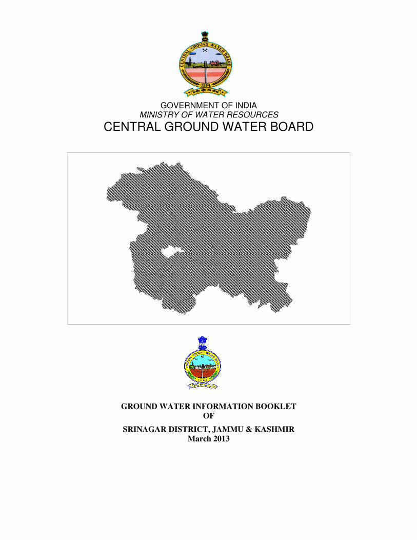
GOVERNMENT OF INDIA MINISTRY OF WATER RESOURCES CENTRAL GROUND WATER BOARD GROUND WATER INFORMATION BOOKLET OF SRINAGAR DISTRICT, JAMMU & KASHMIR March 2013
Transcript of GOVERNMENT OF INDIA MINISTRY OF WATER RESOURCES...
GOVERNMENT OF INDIA
MINISTRY OF WATER RESOURCES
CENTRAL GROUND WATER BOARD
GROUND WATER INFORMATION BOOKLET
OF
SRINAGAR DISTRICT, JAMMU & KASHMIR
March 2013

CONTENTS
SRINAGAR DISTRICT AT A GLANCE
1.0 INTRODUCTION
2.0 CLIMATE AND RAINFALL
3.0 GEOMORPHOLOGY AND SOILS
4.0 GROUND WATER SCENARIO
4.1 Geology
4.2 Hydrogeology
4.3 Depth to water level
4.4 Springs
4.5 Ground Water Resources
4.6 Ground Water Quality
4.7 Status of Ground Water Development
5.0 GROUND WATER MANAGEMENT STRATEGY
5.1 Ground Water Development
5.2 Snow Water Harvesting & Artificial Recharge
6.0 GROUND WATER RELATED ISSUES & PROBLEMS
7.0 AWARENESS & TRAINING ACTIVITY
8.0 AREAS NOTIFIED BY CGWA / SGWA
9.0 RECOMMENDATIONS

SRINAGAR DISTRICT AT A GLANCE
GENERAL INFORMATION Old Srinagar district
including new Srinagar and
Ganderbal districts 1.
i) Geographical area (sq km) 2,228
ii) Administrative Divisions (2009-10)
• Number of Tehsil
• Number of CD Blocks
• Number of Panchayats
• Number of Villages
3
5
113
170
iii) Population (2001 Census)
• Total population
• Population Density (per/sq km)
• SC Population
• ST Population
• Sex Ratio
• Muslims and Other Population
12,02,447 Persons
540
1,065 Persons
45,427 Persons
851
94.66% and 5.34%
iv) Average Annual Rainfall- 2011 (mm) 671 mm
GEOMORPHOLOGY
2. i) Major Physiographic units • High Hill Ranges
• Valleys & Terraces
ii) Important Lakes • Dal , Anchar
iii) Important Hill Range • Zabarvan mountains,
Hari Parbat
iv) Altitude • 1730 m amsl
v) Major Drainages
• Basin
• Sub Basin
vi) Rivers
Indus
Jhelum
Jhelum, Kankanag,Sindh
3. LAND USE (2009-10) (Sq.KM)
• Forest area
• Net area sown
380
388
4. MAJOR SOIL TYPES Hapludalfs and Ochraqualfs
5.
IRRIGATION (2009-10) (Sq.KM)
Net Area Irrigated
• Canals
• Wells
150.16
139.31

• Other Sources
• Tanks
4.28
2.96
3.61
6.
NUMBERS OF GROUND WATER
MONITORING WELLS OF CGWB
(As on 20.03.2013)
• No. of Dug Wells
• No. of Piezometers
02
03
7.
PREDOMINANT GEOLOGICAL FORMATIONS
• Quaternary Alluvium
• Tertiary (Karewas)
• Paleozoic
Sedimentary & Volcanic
rocks
HYDROGEOLOGY 8.
Major Water Bearing Formations
1. Consolidated sediments / Hard Rocks
(Fractured and jointed)
Covering major part
(50%)
• Yield prospects
• GW structures
Moderate (1-3.0 lps)
Springs/Percolation Wells /
Handpumps /Tubewells
2. Semi consolidated sediments
(Karewas)
Covering (25%)
• Yield prospects
• GW structures
Low (5-20 lps)
Springs/
Handpumps/Dugwells
3. Unconsolidated porous sediments
(Alluvium)
Valley area (25%)
• Yield prospects
• GW structures
Moderate (10-40 lps)
Tube wells/
Handpumps/Dugwells
Depth to water level (m bgl)
• Pre-monsoon
• Post - monsoon
2.00-3.00
1.50-2.50
9. GROUND WATER EXPLORATION BY
CGWB (As on 01.12.2012)
• No of wells drilled
• No. of Piezometer
17 EW
03
• Depth Range (m)
• Discharge (lps)
42.65-357.20
4.0-3000
10. GROUND WATER QUALITY
i) Range of Chemical constituents in Ground water
• EC (micro mhos/cm)
335 - 1380

• pH
• Chloride (mg/l)
• Fluoride (mg/l)
• Iron (mg/l)
7.00 – 7.69
7.1 - 92.00
0.01 – 0.42
0.03 – 0.16
11. DYNAMIC GROUND WATER
RESOURCES(2009)
Hectare meter
Annual Replenishable Ground Water Resources 14,895
Net Annual Ground Water Draft 9,277
Projected Demand for Domestic and Industrial
Uses up to 2025
12,368.40
Stage of Ground Water Development 62.28%
12. AWARENESS AND TRAINING ACTIVITY
Mass Awareness Programmes
01
Training programme 01
Work Shop
01
13. EFFORTS OF ARTIFICIAL RECHARGE &
RAINWATER HARVESTING
Nil
14. GROUND WATER CONTROL AND
REGULATION
Number of OE Blocks Nil
No of Critical Blocks Nil
No of blocks notified
Nil

GROUND WATER INFORMATION BOOKLET
OF
SRINAGAR DISTRICT, J & K STATE
1.0 INTRODUCTION
Srinagar district is located in the center of Kashmir valley. Etymologically,
‘Srinagar’ is composed of two Sanskrit words, namely, Sri – meaning abundance and
wealth, and Nagar – which means a city. It is the most pivotal center of economy of the
Kashmir Valley and the city of Srinagar has remained a center of tourist attraction for
centuries. It is situated on the bank of Jhelum River. District Baramulla occupies the
Northern and Western boundary whereas Badgam district forms the Western and South –
Western limits. In the south, Srinagar district is bounded by Pulwama district. The district
lies between 34o01’00” to 34
o29’10” North latitudes and 74
o33’30” to 75
o30’00” East
longitudes. (Plate-I)
Srinagar city is located about 300 km from Jammu and National Highway NH-IA
connects Srinagar with Jammu. All the major carrier operate regular daily flights to
Srinagar from Delhi, Mumbai and Jammu.
Srinagar District was bifurcated in to Srinagar & Ganderbal Districts in the year
2006. As the data for these separate districts was not available with the state
administration, this reports has taken into consideration older Srinagar District as a whole
including newly created Srinagar & Ganderbal Districts. For administrative purpose, the
district is divided into 3 tehsil and 5 blocks and 113 panchayats in the district.
District Srinagar is spread over an area of 2228 sq km comprising three Tehsils of
Srinagar district are, Srinagar, Ganderbal and Kangan and five administrative blocks. The
total population of the district as per 2001 Census was 12,02,447 persons of which
649491 is male population and 552956 is female population with a male / female sex
ratio of 851. The schedule caste population in the district is 1065 persons and scheduled
tribe population is 45,427, of the total population 946166 souls account for urban
population and 256281 as rural population. The growth rate of population during 1991-
2001 recorded an increase of 29.04%.

In Srinagar district major portion of cultivable land has irrigation facility. There is
network of canals and kholas which provide desirable irrigation facility during the
cropping season. During the year 2009-10, an area of 13931 ha was under canal
irrigation, 361 ha under tanks 428 ha under dug wells and tube wells. Net area under
irrigation was 15016 ha.
CGWB has carried out extensive hydrogeological studies both by conventional
and non-conventional methods in the district. Time to time CGWB has carried out
hydrogeological investigations in number of defence establishments in this district and
recommended suitable areas for ground water development. Under groundwater
exploration, 17 exploratory wells have been drilled ranging in depth from 42.0 m at
Pantha Chowk to 359.0 m at Karan Nagar in proper Srinagar while discharge varied from
240 lpm (Upper Ishber) to 3006 lpm (Badampur).
CGWB monitors 2 No’s NHNS stations where ground water levels and ground
water quality is monitored and constructed 3 Piezometers in 2012 in part of National
Aquifer Mapping Programme.
2.0 CLIMATE & RAINFALL
Srinagar district falls under the Temperate to Mediterranean type of climate and is
characterized by mild summers and chilling winters. Due to latitudinal variation from
1,600 meters to 5,000 meters above mean sea level there is a wide variation in climatic
conditions in different parts of the district experiencing a typical temperate climate in
high altitude which experience snowfall and severe cold in the winter and tropical climate
at low altitude. The winter commences from early November and lasts till end of March.
Most of the precipitation received during this period is in the form of snow & the
temperature, at times falls as low as –130C. In December-January the minimum
temperature is generally below freezing point. The period from March to June constitutes
warm summers with temperature rising upto 330C.
Precipitation takes place in the form of rainfall as well as snow with occasional
hailstorms. The average rainfall in the district is about 680 mm. About 60 to 70% of the
precipitation is received in the form of snow during December to February. March to
April are the months of heavy rainfall. May to September are relatively dry months.

3.0 GEOMORPHOLOGY AND SOIL TYPES
The district in general shows the conspicuous physiographic variations
comprising moderately high hills, mountain ranges and alluvial tract. Nearly 50% of the
area is covered by high hills characterized by hilly rugged and undulating topography.
The district forms a part of hilly terrain of the Great-Himalayas and consists of parallel
hill ranges. Flat alluvial terrain/Karewa table lands of late Pliocene to Pleistocene -
Recent sediments occur in the flood plains of rivers and major nallahs of the district. The
alluvial tract occupies the lower elevations and is located at a height of about 1600 meters
above mean sea level. (Plate-II)
The general topographic slope in the northern part is towards the south, in the
southern part is towards north while in the central part the master slope is towards west.
The district is bounded by the Great Himalayas on the South Eastern, Northern, &
North Western side, Jhelum River in the South & it extends and forms the contiguous
portion of the Kashmir Valley in the West. The highest peak is 5148 m above mean sea
level. There are many hill tops in the eastern part of the district with an average height of
3,000 to 4,500 m amsl. Alluvial fans are predominant feature occurring at foothills. In
the Valley portion typical Karewa table lands are noticed. These table lands are flat at the
top with a very gentle slope towards the valley in the periphery portion the Karewas abut
against the mountains.
3.1 SOILS
The soils of the Kashmir Valley are broadly divided into two types viz,
Hapludalfs & Ochraqualfs and the same is true for the Srinagar district also. These soils
are described below:-
i) Hapludalfs
These soils are found on Karewa tops & uplands with a slope variation of 1-3%,
These are very deep soils, well drained with moderate permeability. These soils are
severely eroded resulted in the formation of gullies and ravines.
These are medium to fine textural soils and the surface texture varies from clay
loam to silty clay loam. The colour of the soils varies from Yellowish Brown to dark
Brown. These soils are mostly used for cultivation of Wheat, Maize & pulses.

ii) Ochraqualfs
These soils are found in plain to mid upland topography. These soils are
moderately fine textured with clay loam as the predominant surface texture. The extent of
erosion on such soils is much less. These are dark brown to dark yellowish Brown in
colour. These soils are mostly used because of their low permeability for the cultivation
of Paddy, Mustard & at places Wheat.
3.2 LAKES
The most distinctive feature of the district is Dal lake in the Srinagar City having
an area of about 15 sq.km. This lake has unique life of its own with floating vegetable
gardens, fields of lotus blossom and communities depended upon Dal living in house
boats. The Shikaras with colourful appearance attracts tourists. Jhelum valley is
surrounded by Zabarwan Mountains in the East. Jhelum River flows almost through the
center of the Srinagar city. Another lake Anchar lies in north western part of the district.
4.0 GROUND WATER SCENARIO
4.1 GEOLOGY
The main geological formation in the district are Karewas & Paleozoic
Sedimentaries and Volcanics. These formations are overlain by a thin mantle of Recent
alluvium. The Karewas are overlying the folded Zeewan formation & Panjal volcanics.
In the northern extremity of the valley portion Karewa formations rests over the
Cambrio-Silurians. The general geological successions of the area is as under:-
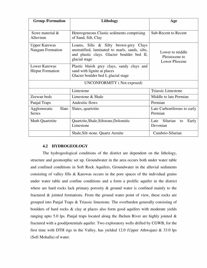
Group /Formation Lithology Age
Scree material &
Alluvium
Heterogeneous Clastic sediments comprising
of Sand, Silt, Clay
Sub-Recent to Recent
Upper Karewas
Naugam Formation
Loams, Silts & Silty brown-grey Clays
unstratified, laminated to marls, sands, silts,
and plastic clays. Glacier boulder bed II,
glacial stage
Lower Karewas
Hirpur Formation
Plastic bluish grey clays, sandy clays and
sand with lignite at places
Glacier boulder bed I, glacial stage
Lower to middle
Pleistocene to
Lower Pliocene
UNCONFORMITY ( Not exposed)
Limestone Triassic Limestone
Zeewan beds Limestone & Shale Middle to late Permian
Panjal Traps Andesitic flows Permian
Agglomreatic Slate
Series
Slates, quartztite Late Carboniferous to early
Permian
Muth Quartztite Quartzite,Shale,Siltstone,Dolomitic
Limestone
Late Silurian to Early
Devonian
Shale,Silt stone. Quartz Arenite Cambrio-Silurian
4.2 HYDROGEOLOGY
The hydrogeological conditions of the district are dependent on the lithology,
structure and geomorphic set up. Groundwater in the area occurs both under water table
and confined conditions in Soft Rock Aquifers, Groundwater in the alluvial sediments
consisting of valley fills & Karewas occurs in the pore spaces of the individual grains
under water table and confine conditions and a form a prolific aquifer in the district
where are hard rocks lack primary porosity & ground water is confined mainly to the
fractured & jointed formations. From the ground water point of view, these rocks are
grouped into Panjal Traps & Triassic limestone. The overburden generally consisting of
boulders of hard rocks & clay at places also form good aquifers with moderate yields
ranging upto 5.0 lps. Panjal traps located along the Jhelum River are highly jointed &
fractured with a good/potentials aquifer. Two exploratory wells drilled by CGWB, for the
first time with DTH rigs in the Valley, has yielded 12.0 (Upper Athwajan) & 33.0 lps
(Sofi Mohalla) of water.

4.3 DEPTH TO WATER LEVEL
Based on the data of water levels of permanent hydrograph network stations, it is
observed that the depth to water table varies widely in different hydro geomorphic
depending upon rainfall, the draft and the topography of the area. There were five
National Hydrograph Network Stations monitored up to the year 1989 by the Central
Ground Water Board in the district and the same are shown in Plate-III. All the five
hydrograph stations falls in Valley fills/ Karewas. At present only two National
Hydrograph Network Stations are being monitored from the year 2007
As there is no monsoon rainfall in the valley and precipitation is received in the
form of snow in the winter (December-March) & rain fall in the early summer (April-
May) is only due to western disturbances, the terms Pre-monsoon & Post-monsoon as
used in the other parts of the country are not relevant in the Kashmir Valley & Summer
and Winter water levels are used for these terms respectively. The depth to summer water
levels in the ranges from 1.5 to 4.00 m bgl (Plate-IV) while winter water levels vary from
1.75 to 6.00 m bgl. It is important to mention here that water level behavior in the
Kashmir Valley is entirely different from the other parts of the country. This is mainly
because of the fact that about 60 to 70% of the precipitation is received in the form of
snow during December to February while March to April are the months of heavy
rainfall. May to September are relatively dry months. Hence recharge to the ground water
takes place in the valley in the months of April to June with the melting of snow and with
the onset of rainfall. Therefore water level shows trends of rising from April onwards and
falling from August onwards.
4.4 SPRINGS
Ground water also emerges in the form of springs at contact of pervious and
impervious beds, along fault planes and other structural features. A good number of
springs are present in the district. Springs are formed when the water table is intercepted
by the topography like river terraces, the morainic masses and the alluvial fans.
In the Panjal Traps the springs are found in the joints & fissures where as in the
limestone formation the springs are seen in the solution cavity and cavernous structures.
The famous Chashma-Shahi spring emanate through this aquifer its water is sweet &

digestive and was used by the people from time immemorial. Pandit Nehru used to get
this water to Delhi.
4.5 GROUND WATER RESOURCES
The dynamic ground water resources of Srinagar district have been estimated for
valley areas only. Total area has been taken as unit for final computation Ground water
resources have been computed as per GEC 1997 methodology & are summarized as
under:-
1. Area considered for GW Assessment (valley area) 550 sq km
2. Annual Replenishable GW Resource during
monsoon & non-monsoon period
14,895 Ham
3. Annual Ground Water Draft 9277 Ham
4. Projected Demand for Future Domestic and
Industrial uses.
12368 Ham
5. Stage of Ground Water Development 62.28 %
The Stage of Ground Water Development was 62.28% as on 2009 which is
categorized as SAFE for future ground water development.
4.6 GROUND WATER QUALITY
The range of various parameters of samples collected from various sources
indicates the suitability of ground water for drinking purposes.
S.
N.
Constituents Range in Srinagar
district
Desirable limit Permissible limit
1. pH 7.00-7.69 6.5-8.5 6.5-8.5
2. EC mmho/cm 335-1380 300 1200
3. Ca ++
(mg/l) 44.0-112.0 75 200
4. Mg ++
(mg/l) 9.7-57.0 30 100
5. CO3 --(mg/l) - - -
6. HCO3 --(mg/l) 177-481 - -
7. Cl (mg/l) 7.1-92.0 250 1000
8. NO3(mg/l) 0.48-90 45 100
9. F(mg/l) 0.01-0.42 1.0 1.5
10. Na +(mg/l) 3.7-100.0 - -
11. K +
(mg/l) 0.2-80.0 - -
12. Fe++ 0.03-0.16 0.3 1.0
13. Total Hardness as Ca
CO3
105-425 300 600

4.7 STATUS OF GROUND WATER DEVELOPMENT
The Stage of Ground Water Development was 62.28% as on 2009 which is
categorized as SAFE for future ground water development. Ground water development in
the district is on moderate scale restricted to the valley portions. All the major irrigation
and drinking water supplies depend on Tube wells, natural springs and rivers and nalas.
In addition to this PHE department constructed number of handpumps in villages to
mitigate the drinking water problems. Public Health Engineering and Irrigation and Flood
control departments are the nodal agencies in the district concerned with the water
supplies for drinking and irrigation respectively. The depth of the hand pumps is about 60
to 70 m bgl. Under groundwater exploration, 17 exploratory wells have been drilled
ranging in depth from 42.0 m (Pantha Chowk) to 359.0 m (Karan Nagar in proper
Srinagar) while discharge varied from 240 lpm (Upper Ishber) to 3006 lpm (BadamPur).
5.0 GROUND WATER MANAGEMENT STRATEGY
5.1 GROUND WATER DEVELOPMENT
Most of the district is in concentrated in valley portion drained by major perennial
river Jhelum and its tributaries. In the past development of ground water was mainly
through dug wells and tubewells, base flow in nallas and also some springs has played a
major role for sustainable domestic and irrigational purposes. In some of the areas, at
present too these are the only sources of water. However, in recent years modern means
of ground water development have been employed. Public Health Engineering has been
constructing number of hand pumps and shallow-moderate depth tube wells for large-
scale water supplies.
5.2 SNOW HARVESTING AND ARTIFICIAL RECHARGE
Snow harvesting is a technique of preservation of snow and delaying the melting so that
snow melt water is available for longer duration in a year. Selection of sites for snow
harvesting shall depend on Insulation of an area, wind direction, wind velocity and
Relative Humidity.
6.0 GROUND WATER RELATED ISSUES & PROBLEMS
Chemically, ground water of the area is by and large fit for drinking and irrigation
requirements.
As depth to water level in the district is shallow there is no scope for artificial
recharge to ground water.
7.0 MASS AWARENESS & TRAINING ACTIVITY
A Mass Awareness Program on “Rainwater Harvesting and Artificial Recharge to
Ground Water” was organized by Central Ground Water Authority and Central Ground
Water Board, North Western Himalayan Region, Jammu, at Ganderbal, District Srinagar,
on 22.02.05 in association with the Department of Rural Development, Srinagar, J&K.
The officers from Sher-I-Kashmir Agriculture University of Science and Technology and
Department of Rural Development, Srinagar, participated in the Program.
Central Ground Water Board, North Western Himalayan Region, Jammu has
successfully organized a one day training Program on the Rainwater Harvesting and
Artificial recharge to ground water in association with Project Formulation Cell, Rural
Development Department, Srinagar at Lal Mandi Complex, Srinagar on 18.02.05. More
then hundred officers from various Departments participated in the training Program.
8.0 AREAS NOTIFIED BY CGWA / SGWA
The stage of ground water development in Srinagar district is 62.28% only and
falls in safe category. Thus, no area or block has been notified for groundwater
development point of view.

9.0 RECOMMENDATIONS
� As the Stage of Ground Water Development is only 62.28% as on March, 2009
which is categorized as SAFE for future ground water development there is
sufficient scope for the ground water development through construction of
different ground water structures.
� Since the depth to water levels in valley portions of the district are within 5 m bgl
the ground water development is required to be given a fillip by funding agencies
through State Government providing soft loans on liberal terms may be
considered by the State Government agencies for construction of Shallow Tube
wells, dug wells, hand pumps etc. The construction of such structure tapping the
shallow aquifers will also minimizes the chances of getting comparatively higher
Iron content which is regular problem in the Karewas.
� At moderate to higher reaches of the district the water conservation techniques are
required to be adopted wherein various structures like gabions, check dams,
contour bunding, treatment of catchments of village ponds etc. should be taken
up. This will help to mitigate drinking and irrigation water need of the villagers at
large.
� Since there are data gaps in monitoring of depth to water levels in the district it is
recommended to reestablish National Hydrograph Network Stations and / or
install piezometers so that behavioral changes of water levels could be observed
over a long period of time in order to know the trends.
-------------------------------------------------------------


Wells
feasible
Rigs suitable Depth of
well (m)
Discharge
(lpm)
Suitable artificial
recharge structures
Soft rock
aquifers
Tube well
Dug Well
Percussion,
Rotary, DTH
with Odex
Manual/Poclain
60 to
250�
6 to 10
150 to 1000
150 to 400
Hard rock
aquifers
Tube well
Dug Well
Spring
Development
DTH with
Odex
Manual/Poclain
40 to 80
4 to 8
150 to 600
150 to 600
30 to 1200
Check dam, Check
Dam cum ground
Water dam, Recharge
Shaft/pit
Hilly area
5 Water level contour (m bgl)
(Pre monsoon decadal mean, 1993-
2002)
• Springs
- - - - - - - Tehsil boundary � Tehsil HQ
District boundary � District HQ
Major Drainage Resevior
OTHER INFORMATIONS
Total area 2228 sq.km
No. of tehsils 5
Major drainage Jhelum, Sind Rivers
Population 1202447 (2001 Census)
Rainfall 671 mm
Temperature - 90 C to 35 C
Soft rock : - Alluvium, Karewas Regional geology
Hard rock : - Panjal traps
Ground water quality EC<750 micro mhos/cm at 250C
Stage of GW development 62.28 %
Name of watershed/ tehsil showing intensive GW Nil
LEGEND PLATE-V