GOING FOR GOLD beneath the Tanami - Geoscience … · GEOSCIENCE AUSTRALIA ISSUE 79 September 2005...
2
GEOSCIENCE AUSTRALIA ISSUE 79 September 2005 ISSUE 79 September 2005 Bruce Goleby A principal objective of Geoscience Australia’s North Australia Project is to assess the geology of the region and its known and potential mineral systems, particularly those associated with the gold deposits of the Tanami (see AusGeo News 74). The Tanami National Geoscience Accord (NGA) Project—a collaborative initiative between Geoscience Australia, the Northern Territory Geological Survey and the Geological Survey of Western Australia—evolved from this work to more directly target controls on lode gold mineralisation. GOING FOR GOLD beneath the Tanami A seismic acquisition project to identify big structures in the Tanami region will greatly assist mineral explorers. Figure 1. Location map of the Tanami region, northern Australia, showing the four Tanami traverses (05GA-T1 through to 05GA-T4). The dotted portion of 05GA-T1 indicates extra kilometres collected due to additional funding and excellent crew performance. A total of approximately 720 line kilometres were recorded. Locations of mineralisation are shown as circles. ▼ Figure 2. ANSIR (through Terrex Seismic Pty Ltd) seismic acquisition in operation in the Tanami with three IVI 60 000 lb vibrators operating on traverse 05GA-T2 to send signals through whole of crust and back. ▼ To answer questions arising from the newly constructed 3D model of the Tanami region (www.ga.gov.au/map/web3d/tanami/index.jsp), the collaborators agreed that collection of seismic data across the region was crucial. This data will greatly assist mineral explorers in discovering new mineral deposits. The seismic reflection technique is considered the most suitable method to understand Tanami architecture at depth, including the key regional structures and fluid pathways that operated as part of the region’s gold mineral system. To facilitate this, the Tanami Seismic Collaborative Research Project—involving the Tanami NGA Project partners plus Newmont Exploration Pty Ltd and Tanami Gold NL—designed a program of seismic traverses to focus on the crustal architecture of the region and key structures connected with gold mineralisation. Arrangements for the project began in April 2004, with the commencement of line preparation and surveying. Under the supervision of the Australian National Seismic Imaging Resource (ANSIR) through its facilities manager, Terrex Seismic Pty Ltd, seismic acquisition began in May 2005, working from west to east. The survey finished in early July, after completing all of traverse 05GA-T1.
Transcript of GOING FOR GOLD beneath the Tanami - Geoscience … · GEOSCIENCE AUSTRALIA ISSUE 79 September 2005...
GEOSCIENCE AUSTRALIA
ISSUE 79 September 2005
ISSUE 79 September 2005
Bruce Goleby
A principal objective of Geoscience Australia’s North Australia Project is to assess the geology of the region and its known and potential mineral systems, particularly those associated with the gold deposits of the Tanami (see AusGeo News 74).
The Tanami National Geoscience Accord (NGA) Project—a collaborative initiative between Geoscience Australia, the Northern Territory Geological Survey and the Geological Survey of Western Australia—evolved from this work to more directly target controls on lode gold mineralisation.
GOING FOR GOLD beneath the TanamiA seismic acquisition project to identify big structures in the Tanami region will greatly assist mineral explorers.
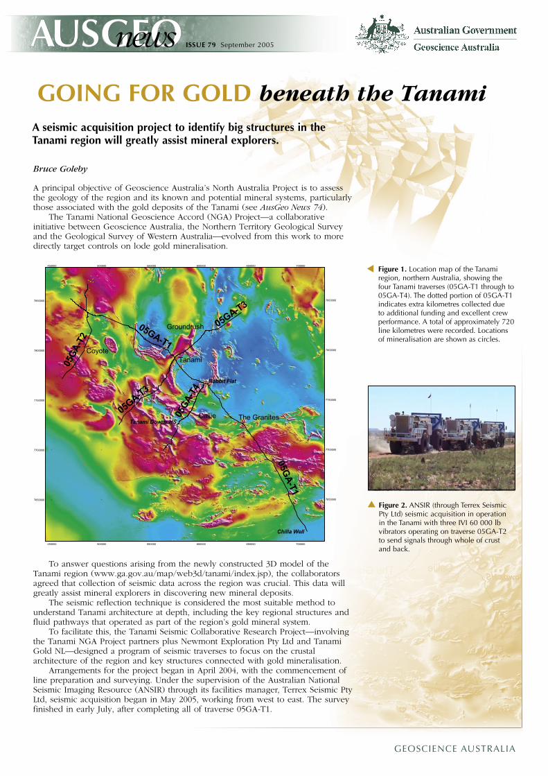
Figure 1. Location map of the Tanami region, northern Australia, showing the four Tanami traverses (05GA-T1 through to 05GA-T4). The dotted portion of 05GA-T1 indicates extra kilometres collected due to additional funding and excellent crew performance. A total of approximately 720 line kilometres were recorded. Locations of mineralisation are shown as circles.
▼
Figure 2. ANSIR (through Terrex Seismic Pty Ltd) seismic acquisition in operation in the Tanami with three IVI 60 000 lb vibrators operating on traverse 05GA-T2 to send signals through whole of crust and back.
▼
To answer questions arising from the newly constructed 3D model of the Tanami region (www.ga.gov.au/map/web3d/tanami/index.jsp), the collaborators agreed that collection of seismic data across the region was crucial. This data will greatly assist mineral explorers in discovering new mineral deposits.
The seismic reflection technique is considered the most suitable method to understand Tanami architecture at depth, including the key regional structures and fluid pathways that operated as part of the region’s gold mineral system.
To facilitate this, the Tanami Seismic Collaborative Research Project—involving the Tanami NGA Project partners plus Newmont Exploration Pty Ltd and Tanami Gold NL—designed a program of seismic traverses to focus on the crustal architecture of the region and key structures connected with gold mineralisation.
Arrangements for the project began in April 2004, with the commencement of line preparation and surveying. Under the supervision of the Australian National Seismic Imaging Resource (ANSIR) through its facilities manager, Terrex Seismic Pty Ltd, seismic acquisition began in May 2005, working from west to east. The survey finished in early July, after completing all of traverse 05GA-T1.
GEOSCIENCE AUSTRALIA
ISSUE 79 September 2005
The main objectives are to:• image the geometry of the main faults• determine a deformation sequence for these faults• identify any through-going crustal structures• determine stratigraphic thicknesses of the Tanami Group and granite body
geometries• determine relationships of the various stratigraphic packages to controlling
structures• investigate the relationship of mineralised domains to crustal scale
structures• identify Archaean basement and its relationship to the overlying Tanami
Group stratigraphy• investigate the character of the Tanami–Arunta boundary.
The Tanami seismic survey consists of four traverses totalling 724 kilometres (05GA-T1 through to 05GA-T4). Traverse 05GA-T1 is a northwest–southeast regional transect, while traverses 05GA-T2, 05GA-T3 and 05GA-T4 provide orthogonal 3D control on the geometry of the region’s main fault systems (figure 1). The seismic traverses run close to the Coyote, Tanami, Groundrush and Callie mine sites and will provide information on the deeper structures in these areas.
The seismic data provides valuable 3D information about the Tanami crust, and will also help mineral explorers find new mineral deposits. In conjunction with the seismic acquisition, the Northern Territory Geological Survey is collecting 400-metre gravity data along each of the seismic traverses. Geoscience Australia is also collecting wide-angle velocity data along regional traverse 05GA-T1.
The seismic data was acquired using ANSIR’s seismic reflection system, consisting of an ARAM24 (24-bit) seismic reflection recording system with 10 Hz geophones and three IVI 60 000 lb vibrators operating at all times (figure 2).
Processing began in June 2005, and is expected to be completed early in 2006. The five partners will begin interpretation in late 2005, and hope to have final interpreted sections by mid-2006.
The collaborators plan to hold a workshop on the seismic results soon after the data synthesis and final interpretations are completed. The results will be published as a Geoscience Australia Record in July–August 2006.
For more information phone Bruce Goleby on +61 2 6249 9404 (email [email protected]) or David Huston on +61 2 6249 9577 (email [email protected])
• A search on your special topic
• A customised bibliography
• An Alert profile for your particular field
• A document request
Information about:• Australian geoscience
• Papers from Australian geoscience conferences and journals
• The latest research in your particular field
• An Australian geographic location or a geological feature
Annual subscription costs start from $US95.00.
Try the 30 day free trial (http://www.ausgeoref.org)
AusGeoRef Australian Geoscience References
in collaboration with
For more information phone + 61 2 6249 9567 or e-mail Geoscience Australia’s Reference Library ([email protected])