GNSS Remote Sensing from Space: Selected … · • Development of a simulation tool for GNSS-R...
37
ICGPSRO 2018 April 20, Taipeh GNSS Remote Sensing from Space: Selected European and German Activities J. Wickert, E. Cardellach, C. Arras, A. Camps, C. Gommenginger, F. Flechtner, H. Fragner, S.V. Nghiem, N. Pierdicca, J. Saynisch, T. Schmidt, M. Semmling, and F. Zus MANY THANKS to NSPO for the invitation!
Transcript of GNSS Remote Sensing from Space: Selected … · • Development of a simulation tool for GNSS-R...
ICGPSRO 2018 April 20, Taipeh
GNSS Remote Sensing from Space: Selected European and German Activities
J. Wickert, E. Cardellach, C. Arras, A. Camps, C. Gommenginger,
F. Flechtner, H. Fragner, S.V. Nghiem, N. Pierdicca, J. Saynisch, T. Schmidt, M. Semmling, and F. Zus
MANY THANKS to NSPO for the invitation!

ICGPSRO 2018 April 20, Taipeh
These missions are introduced/reviewed
• GRACE-Follow On (U.S./Germany)
• GEROS-ISS (ESA)
• G-TERN (ESA)
• AtmoSat (Germany)
• PRETTY (Austria/ESA)

ICGPSRO 2018 April 20, Taipeh
GRACE-FO
Gravity Recovery And Climate Experiment– Follow On
ICGPSRO 2018 April 20, Taipeh
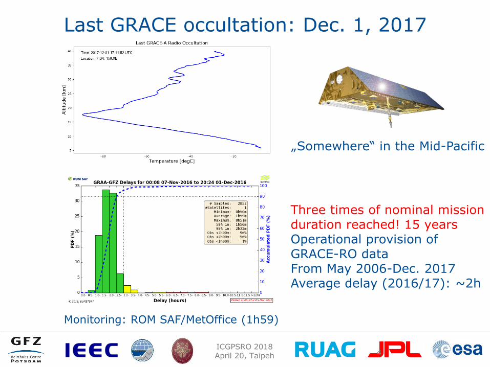
Last GRACE occultation: Dec. 1, 2017
4
Three times of nominal mission duration reached! 15 years Operational provision of GRACE-RO data From May 2006-Dec. 2017 Average delay (2016/17): ~2h
Monitoring: ROM SAF/MetOffice (1h59)
„Somewhere“ in the Mid-Pacific
ICGPSRO 2018 April 20, Taipeh
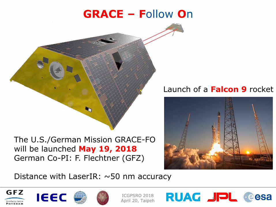
GRACE – Follow On
5
Launch of a Falcon 9 rocket
The U.S./German Mission GRACE-FO will be launched May 19, 2018 German Co-PI: F. Flechtner (GFZ) Distance with LaserIR: ~50 nm accuracy

ICGPSRO 2018 April 20, Taipeh
GNSS atmosphere sounding with GRACE-FO
New and improved GNSS receiver compared to GRACE: TriG
Aspects: Galileo ?, L2C/L5 is feasible, joint effort JPL/Moog/GFZ required
Activation not before launch+30d; forward/backward occultations, operational processing chain is prepared for data analysis
TriG RO receiver
ICGPSRO 2018 April 20, Taipeh
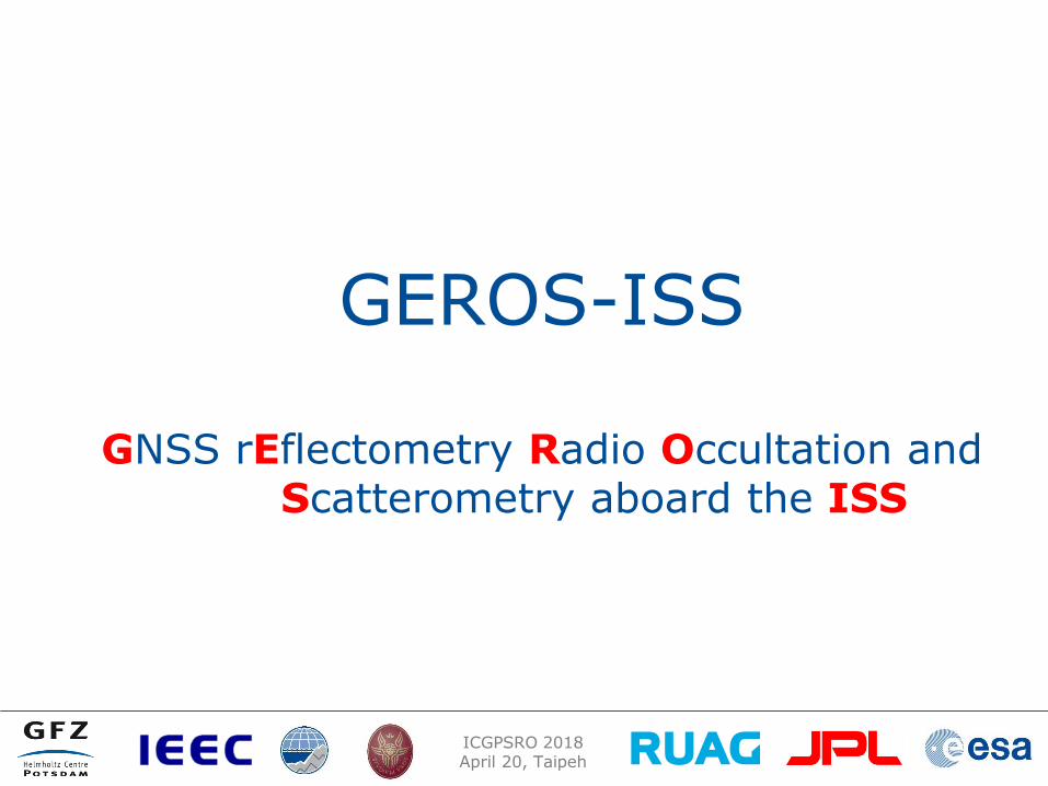
GEROS-ISS
GNSS rEflectometry Radio Occultation and Scatterometry aboard the ISS

ICGPSRO 2018 April 20, Taipeh
GPS (~30) Galileo (~30)
Atmosphere, Ionosphere, Water, Ice
Water & Ice & Land
+GLONASS (~24)
GNSS aboard ISS
Beidou (~30) Precise Orbit &
Ionosphere

ICGPSRO 2018 April 20, Taipeh
Mission idea: Mesoscale Ocean Currents (Eddies)
ICGPSRO 2018 April 20, Taipeh
GEROS-ISS: Status Interdisciplinary Science Advisory Group (SAG) 2013-2017 J. Wickert (Chair), E. Cardellach (Co-Chair), O. Andersen, B. Chapron, C. Gommenginger, N. Pierdicca, A. Jäggi, M. Martin-Neira, C.K. Shum, C. Zuffada
Initial Mission and System Requirements in 2013
Two industrial Phase A study finished 2016, ADS (Airbus Defense and Space, Spain), TAS (Thales Alenia Space, Italy).
Science Study GARCA (GNSS-R – Assessment of Requirements and Consolidation of Retrieval Algorithms, Final Report Nov 2016)
Flight campaigns May/Dec 2015
Three OSSE ocean observations (JPL, GFZ, NERSC)
Cost reduction exercise finished 2017 and EE-9 proposal with strong GEROS heritage submitted (G-TERN), no recent activity IEEE overview paper available (Wickert et al., 2016)
ICGPSRO 2018 April 20, Taipeh
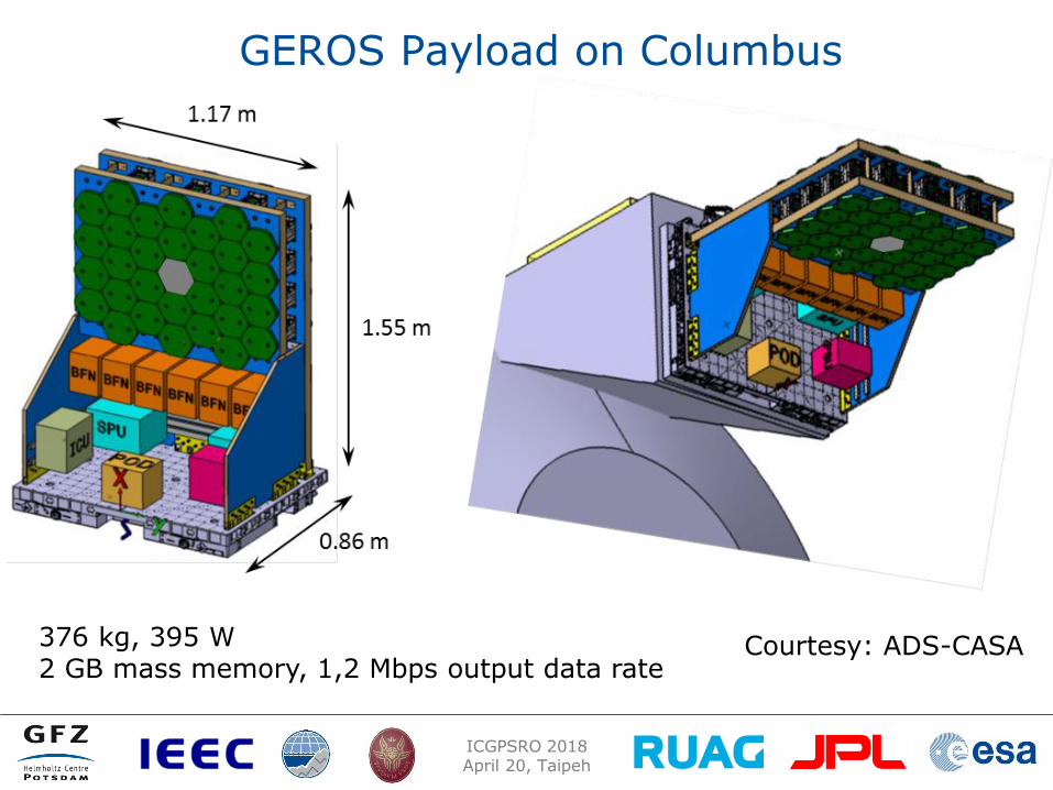
GEROS Payload on Columbus
Courtesy: ADS-CASA 376 kg, 395 W 2 GB mass memory, 1,2 Mbps output data rate
ICGPSRO 2018 April 20, Taipeh
Scientific activities
ICGPSRO 2018 April 20, Taipeh
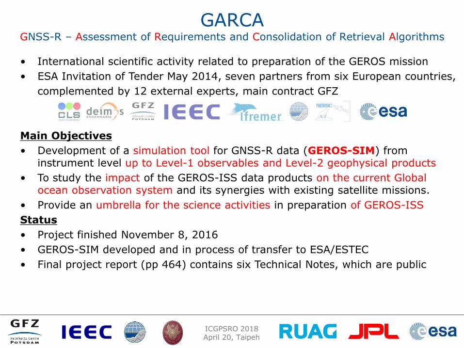
GARCA GNSS-R – Assessment of Requirements and Consolidation of Retrieval Algorithms
• International scientific activity related to preparation of the GEROS mission
• ESA Invitation of Tender May 2014, seven partners from six European countries,
complemented by 12 external experts, main contract GFZ
Main Objectives
• Development of a simulation tool for GNSS-R data (GEROS-SIM) from instrument level up to Level-1 observables and Level-2 geophysical products
• To study the impact of the GEROS-ISS data products on the current Global ocean observation system and its synergies with existing satellite missions.
• Provide an umbrella for the science activities in preparation of GEROS-ISS
Status
• Project finished November 8, 2016
• GEROS-SIM developed and in process of transfer to ESA/ESTEC
• Final project report (pp 464) contains six Technical Notes, which are public
ICGPSRO 2018 April 20, Taipeh
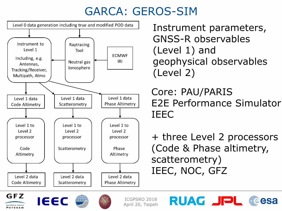
GARCA: GEROS-SIM
Instrument parameters, GNSS-R observables (Level 1) and geophysical observables (Level 2)
Core: PAU/PARIS E2E Performance Simulator IEEC + three Level 2 processors (Code & Phase altimetry, scatterometry) IEEC, NOC, GFZ
ICGPSRO 2018 April 20, Taipeh
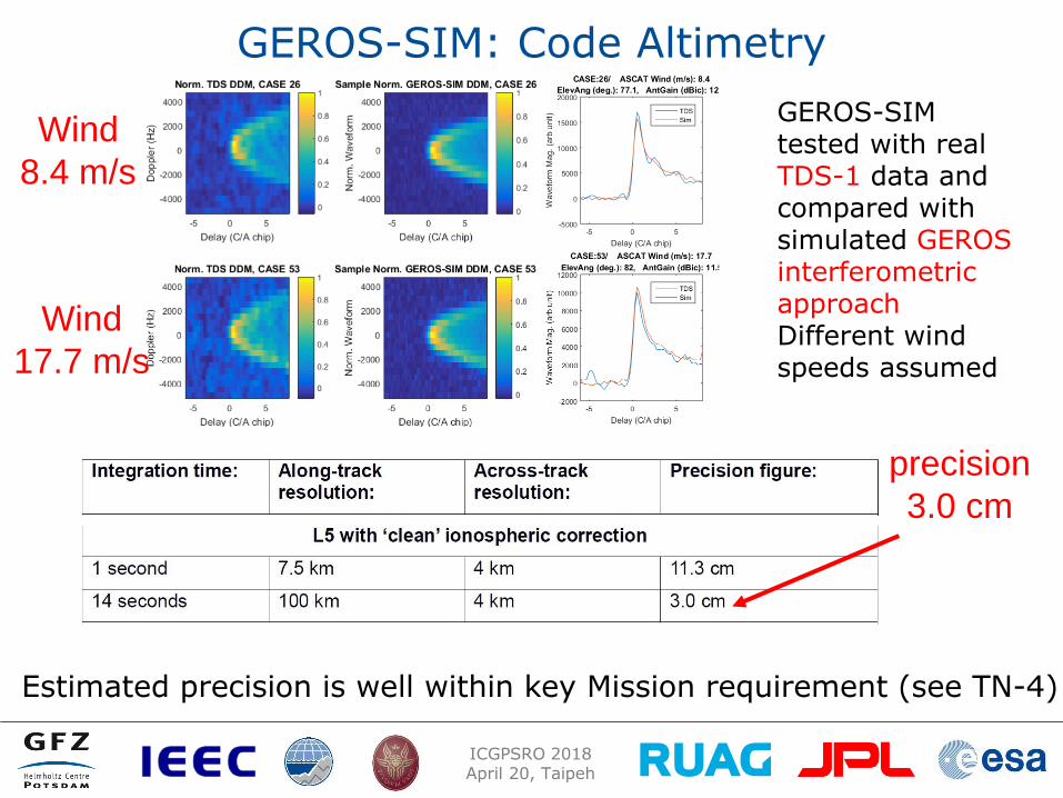
GEROS-SIM: Code Altimetry
Estimated precision is well within key Mission requirement (see TN-4)
GEROS-SIM tested with real TDS-1 data and compared with simulated GEROS interferometric approach Different wind speeds assumed
Wind
8.4 m/s
Wind
17.7 m/s
precision
3.0 cm
ICGPSRO 2018 April 20, Taipeh
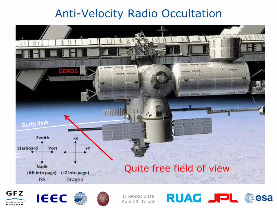
Anti-Velocity Radio Occultation
GEROS-ISS GEROS
Quite free field of view
ICGPSRO 2018 April 20, Taipeh
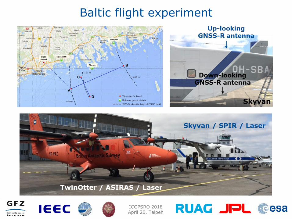
Baltic flight experiment
Skyvan / SPIR / Laser
TwinOtter / ASIRAS / Laser

ICGPSRO 2018 April 20, Taipeh
OSSE in South China Sea during Typhoon Rammsun
NERSC, Norway Three months of assimilation of simulated GNSS-R data in the model and data assimilation system with HYCOM model (5 km) on top of the operationally used Radar-Satellite data (4) also during typhoon period in July 2014
Simulated observations Three experiments: * GEROS-ISS (limited FoV) * Free Flyer FoV-1 (Jason like) * Free Flyer FoV-2 (Jason like)
Assumed errors (precision): 25 cm (10 km)
One example: (TN-5 GARCA) Improvement of SLA recon-struction with GNSS-R F-FoV2 compared to use of traditional altimetry satellite data only up to 50% (for GEROS up to 20%) Xie/Bertino et al. (NERSC, 2017)

ICGPSRO 2018 April 20, Taipeh
Earth Explorer 9 proposal
G-TERN
GNSS – Transpolar Earth Reflectometry exploriNg system

ICGPSRO 2018 April 20, Taipeh
Principal Investigators: E. Cardellach (IEEC, Spain) J. Wickert (GFZ, Germany) Interdisciplinary science team: Polar science Oceanography Sea level Climate Meteorology Land applications Geodesy and GNSS Space engineering Space weather 25 colleagues from 11 countries Industry team: 8 colleagues from 7 companies in 5 countries, including OHB (prime), Airbus, RUAG
ICGPSRO 2018 April 20, Taipeh
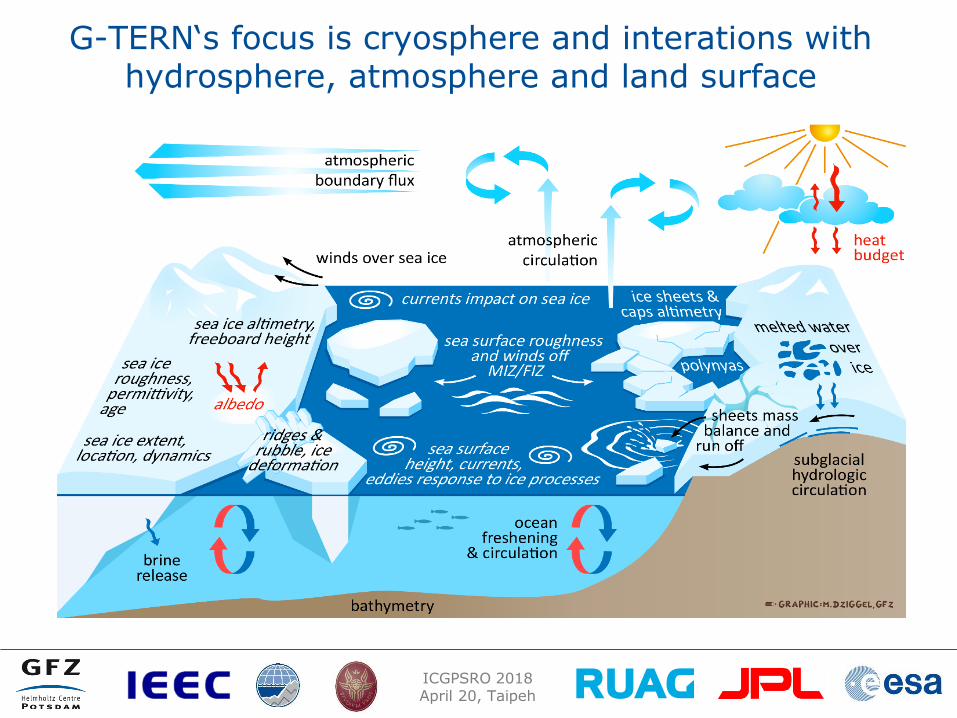
G-TERN‘s focus is cryosphere and interations with hydrosphere, atmosphere and land surface
ICGPSRO 2018 April 20, Taipeh
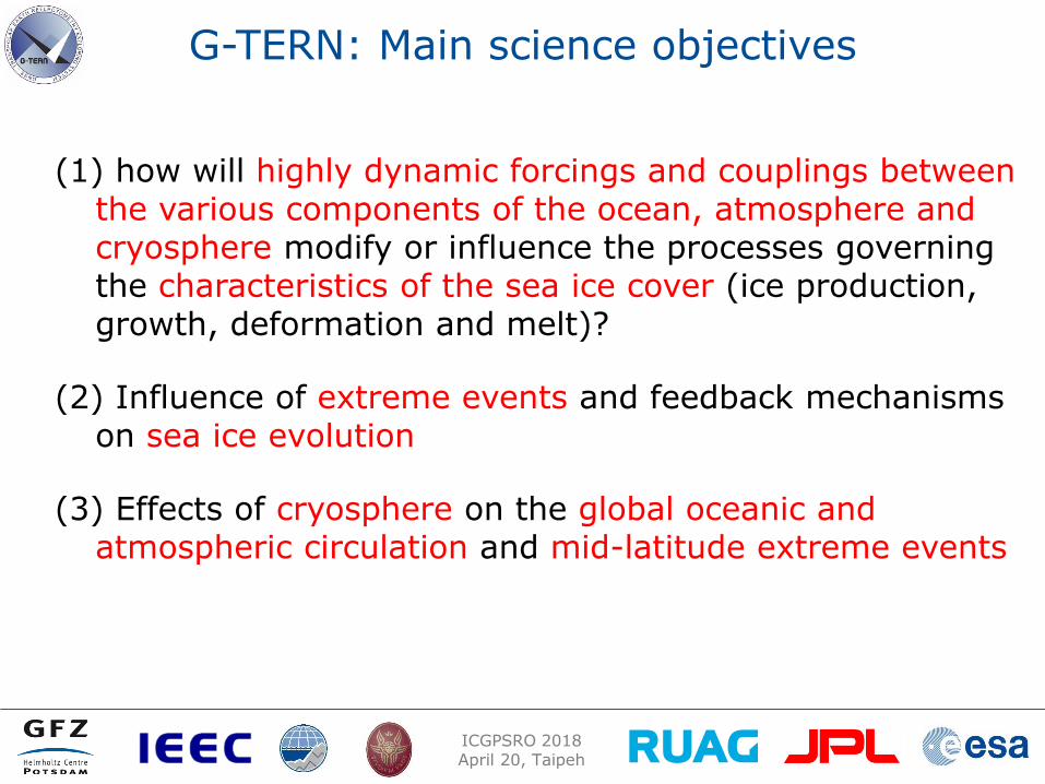
G-TERN: Main science objectives
(1) how will highly dynamic forcings and couplings between the various components of the ocean, atmosphere and cryosphere modify or influence the processes governing the characteristics of the sea ice cover (ice production, growth, deformation and melt)?
(2) Influence of extreme events and feedback mechanisms on sea ice evolution
(3) Effects of cryosphere on the global oceanic and atmospheric circulation and mid-latitude extreme events

ICGPSRO 2018 April 20, Taipeh
G-TERN: Secondary objectives (1/2) ..
potential to extract (additional) cryosphere data products as:
snow cover over sea ice, its thickness and density
sea ice permittivity, density and/or brine content
sea ice surface melt onset and melt pond fraction
distinction between modal (thermodynamic) and dynamical (deformation) growth of the sea ice?
ice sheets and large caps, their surface elevation changes, mass balance, run offs, melting episodes, surface and sub-surface snow properties
permafrost active layer changes, freeze and thaw phase, surface deformations
seasonal snow in mid latitudes, its thickness and snow properties
glacier evolution

ICGPSRO 2018 April 20, Taipeh
Main data products and observation requirements
Actual spatial resolution of 1-snapshot reflection: ~ 300-600 m when coherent (e.g. sea ice) ~10 km when diffuse (e.g. ocean)
ICGPSRO 2018 April 20, Taipeh
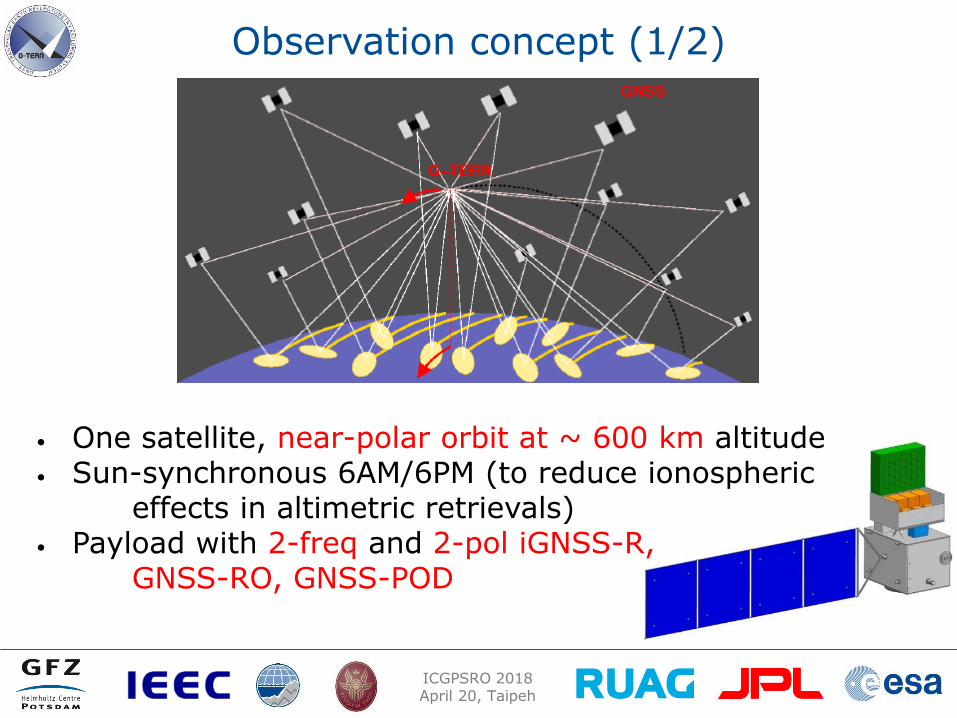
Observation concept (1/2)
• One satellite, near-polar orbit at ~ 600 km altitude • Sun-synchronous 6AM/6PM (to reduce ionospheric
effects in altimetric retrievals) • Payload with 2-freq and 2-pol iGNSS-R, GNSS-RO, GNSS-POD
ICGPSRO 2018 April 20, Taipeh
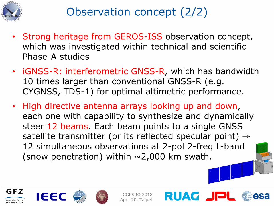
Observation concept (2/2)
• Strong heritage from GEROS-ISS observation concept, which was investigated within technical and scientific Phase-A studies
• iGNSS-R: interferometric GNSS-R, which has bandwidth 10 times larger than conventional GNSS-R (e.g. CYGNSS, TDS-1) for optimal altimetric performance.
• High directive antenna arrays looking up and down, each one with capability to synthesize and dynamically steer 12 beams. Each beam points to a single GNSS satellite transmitter (or its reflected specular point) →
12 simultaneous observations at 2-pol 2-freq L-band (snow penetration) within ~2,000 km swath.
ICGPSRO 2018 April 20, Taipeh
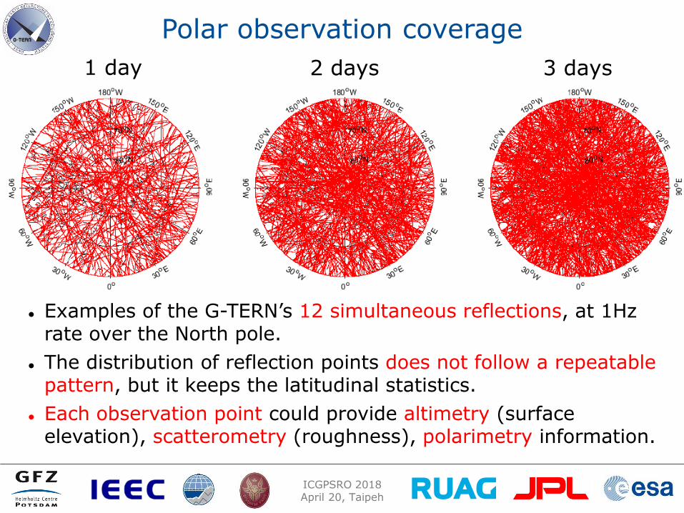
Polar observation coverage
Examples of the G-TERN’s 12 simultaneous reflections, at 1Hz rate over the North pole.
The distribution of reflection points does not follow a repeatable pattern, but it keeps the latitudinal statistics.
Each observation point could provide altimetry (surface elevation), scatterometry (roughness), polarimetry information.
1 day 2 days 3 days

ICGPSRO 2018 April 20, Taipeh
Examples with existing data (1/2)
GNSS-R phase delay altimetry over Hudson Bay sea ice (TDS-1 at ~50 deg incidence in raw sampling and processed on ground).
Dots: altimetric retrievals at 20 msec sampling using two different sets of corrections; Solid line: Canadian Geodetic Vertical Datum local geoid 2013.
RMS differences with the geoid are 2.6 and 3.5 cm
Fig. from: Li et al., 2017
ICGPSRO 2018 April 20, Taipeh
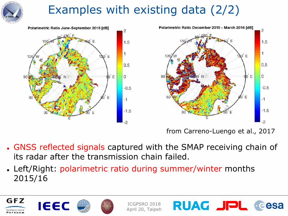
Examples with existing data (2/2)
GNSS reflected signals captured with the SMAP receiving chain of its radar after the transmission chain failed.
Left/Right: polarimetric ratio during summer/winter months 2015/16
from Carreno-Luengo et al., 2017

ICGPSRO 2018 April 20, Taipeh
Which missions were selected for EE9 Phase A ?
FORUM (Far-infrared Outgoing Radiation Understanding and Monitoring), better understanding of greenhouse effect (water vapor, cirrus clouds)
SKIM (Sea-surface KInematics Multiscale monitoring), novel wide-swath scanning multibeam radar altimeter to measure ocean-surface currents. Doppler technique offers more direct measurements than conventional satellite altimeters. One mission selected in 2020, launch expected for early 2025
What about G-TERN?
Among the 4 (non-selected) missions proposed for ancillary support. Scientific value of the new observation type for cryopshere is recognized. Further studies are recommended in cooperation with cryospheric community.
Recent IEEE overview paper available (Cardellach et al. 2018)

ICGPSRO 2018 April 20, Taipeh
AtmoSat: A potential GNSS-RO
platform with good chance

ICGPSRO 2018 April 20, Taipeh
AtmoSat
TriG RO receiver
• Satellite mission for the investigation of the atmospheric variability, Improvement of regional climate and mid term weather prediction
• KIT/FZJ leading, GFZ additional leading institution
• Strong heritage from PREMIER mission (proposed EE8 mission)
• Proposed in 2016 within large research structure investments in Germany (>50 Mio€)
• Scientific evaluation with highest possible result in July 2017, final decision summer 2018
• Key payload: GLORIA (3D atmosphere mapping); GFZ plans to provide TriG RO receiver
• Launch planned for 2023

ICGPSRO 2018 April 20, Taipeh
PRETTY Passive REflecTomeTrY
A cubesat for phase altimetry
ICGPSRO 2018 April 20, Taipeh
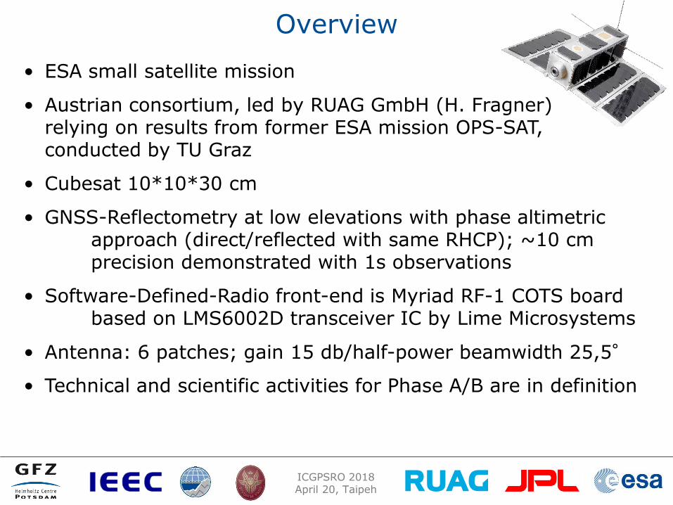
Overview
• ESA small satellite mission
• Austrian consortium, led by RUAG GmbH (H. Fragner) relying on results from former ESA mission OPS-SAT, conducted by TU Graz
• Cubesat 10*10*30 cm
• GNSS-Reflectometry at low elevations with phase altimetric approach (direct/reflected with same RHCP); ~10 cm precision demonstrated with 1s observations
• Software-Defined-Radio front-end is Myriad RF-1 COTS board based on LMS6002D transceiver IC by Lime Microsystems
• Antenna: 6 patches; gain 15 db/half-power beamwidth 25,5°
• Technical and scientific activities for Phase A/B are in definition

ICGPSRO 2018 April 20, Taipeh
PRETTY subsystem arrangement
ICGPSRO 2018 April 20, Taipeh
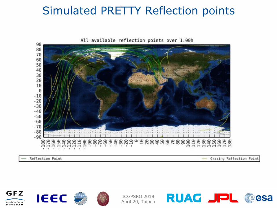
Simulated PRETTY Reflection points
ICGPSRO 2018 April 20, Taipeh
Summary
• Several selected recent European GNSS remote sensing mission were briefly reviewed.
• Launch of GRACE-FO for GNSS-RO is planned for May 19, 2018. Similar operational processing is planned as for GRACE.
• Extensive European activities within GEROS-ISS (GNSS-R/RO) mainly for ocean altimetry were summarized. Science Advisory Group finished activities.
• G-TERN is a combined GNSS-R/RO mission with focus to Cryosphere, proposed within Earth Explorer 9. G-TERN was recommended for further studies.
• AtmoSat is a german atmospheric science mission including GNSS-RO. Final decision expected for spring 2018.
• The Cubesat mission PRETTY and related science activities are in preparation.