GMES Services - ECMWF• Marine & Coastal Information Services Alcatel (F) • Flood & Fire Risk...
32
GMES Services presented by C. Zehner ESA/ESRIN
Transcript of GMES Services - ECMWF• Marine & Coastal Information Services Alcatel (F) • Flood & Fire Risk...

GMES Services
presented by C. ZehnerESA/ESRIN

• GMES Services Element• Background / Status
• GSE Contribution to Fast-Tracks• Engaged user base & documented requirements• Service Delivery & Qualification• 2008...
Outline

GMES Services Element
2003 2004 2005 2006
Consolidate 2 portfolios
Scale-up next 2 portfolios
Consolidate maritime security
Consolidate 10 Service Portfolios
Consolidate services
2007 2008 2009
Socio- economic Study Service evolution study
Scale-up 7 portfolios
Extensions to consolidated Service portfolios
Scale-up services

GSE Services Stage 2 : 2006 – 2008/9
2005 - 2008• Forest Monitoring Services GAF (D)• Land Information Infoterra (D)• Polar Information Services C-CORE (CDN)• Marine & Coastal Information Services Alcatel (F)• Flood & Fire Risk Services Infoterra (F)• Geo-hazard (Land motion) Information Servic NPA (UK)• Food Security Information Services Vito (B)
2006 - 2009• Atmospheric Monitoring Services DLR (D)• Humanitarian Aid Information Services Infoterra UK
2005 – 2007 (consolidation)• Maritime Security Telespazio (I)
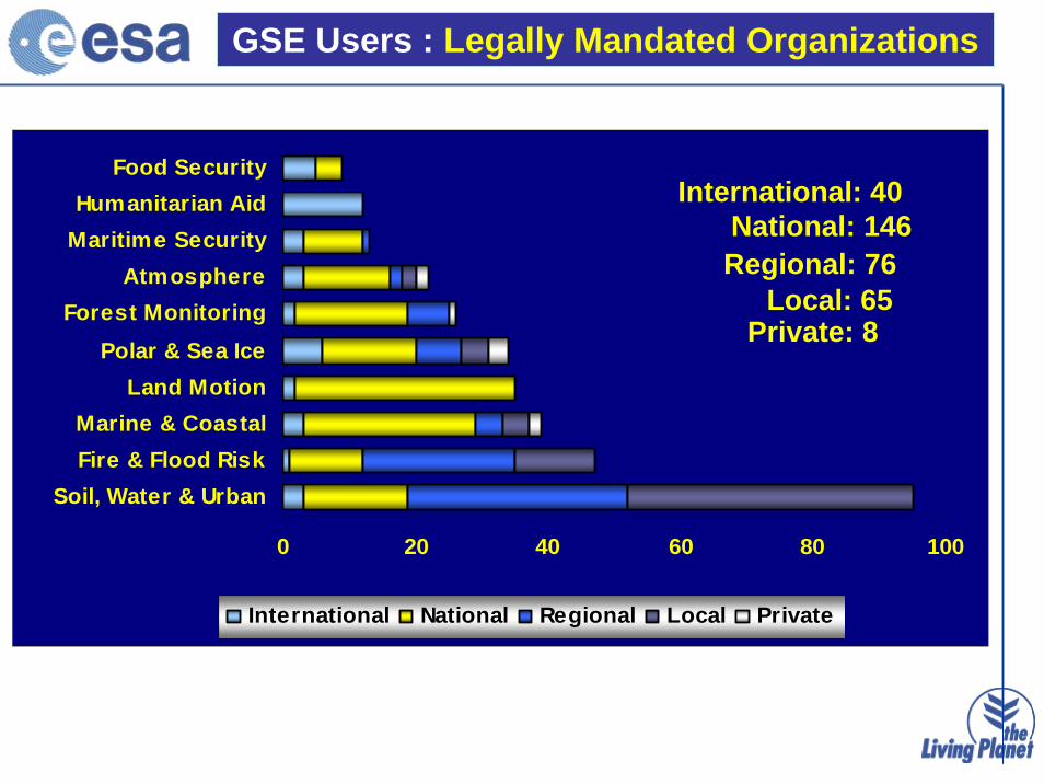
GSE Users : Legally Mandated Organizations
0 20 40 60 80 100
Soil, Water & UrbanFire & Flood RiskMarine & Coastal
Land MotionPolar & Sea Ice
Forest MonitoringAtmosphere
Maritime SecurityHumanitarian Aid
Food Security
International National Regional Local Private
International: 40National: 146Regional: 76
Local: 65Private: 8

GSE Users : in 35 Countries
0 10 20 30 40 50
IntOth
EU 25DFEI
UKCA
SB
FNN
GRA
NLP
CHIE
DKLU
Unique Users Users Accessing Additional Services
Unique Users: 316Users Accessing Multiple Services: 19
Number of Countries: 35

GSE Service Providers : Industry & Institutions
0 5 10 15 20 25
Marine & CoastalForest Monitoring
Polar & Sea IceSoil, Water & Urban
Fire & Flood RiskFood SecurityAtmosphere
Humanitarian AidMaritime Security
Land Motion
SME Pub Inst Gov Agency Large Co Univ
SME’s: 65Public Institutions: 29
Government Agencies: 12Large Companies: 11
Universities: 6

• readily accessible to users when needed• now & in future
• Reliable• consistently meet user-defined quality • & standards
• Affordable• overall benefits justify costs
What is a sustainable service ?
• Useful
• Available
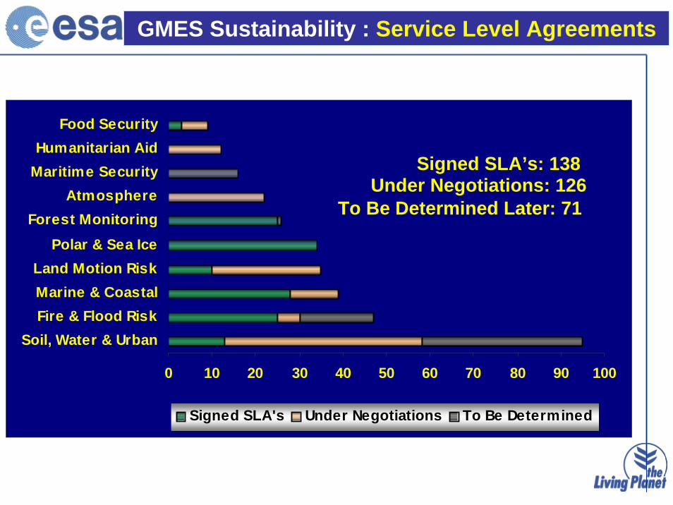
GMES Sustainability : Service Level Agreements
0 10 20 30 40 50 60 70 80 90 100
Soil, Water & UrbanFire & Flood RiskMarine & CoastalLand Motion Risk
Polar & Sea IceForest Monitoring
AtmosphereMaritime SecurityHumanitarian Aid
Food Security
Signed SLA's Under Negotiations To Be Determined
Signed SLA’s: 138Under Negotiations: 126
To Be Determined Later: 71
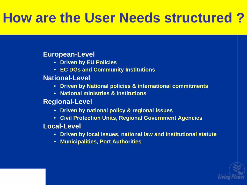
How are the User Needs structured ?
European-Level• Driven by EU Policies• EC DGs and Community Institutions
National-Level• Driven by National policies & international commitments• National ministries & Institutions
Regional-Level• Driven by national policy & regional issues• Civil Protection Units, Regional Government Agencies
Local-Level• Driven by local issues, national law and institutional statute• Municipalities, Port Authorities

Madrid
SAIL Region
Moselle-Sarre
Weser
Lake Constance Area
Jucar
Ljusnan Kokemäenjoki
Guadalquivir tributaries
Ebro
Adour-Garonne
Tajo
Düsseldorf
VicenzaVenezia
Bari
Impervious Areas
Water Quality
Overlap Areas
Irrigation
Urban Atlas Cities
GSE Land Services Delivery: 2006-2008
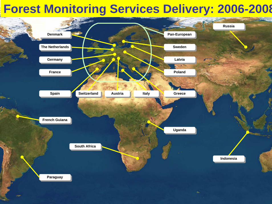
French Guiana
South Africa
Indonesia
Russia
Austria
Sweden
Latvia
Pan-European
Germany
The Netherlands
France
GreeceItalySwitzerlandSpain
Denmark
Uganda
Paraguay
Poland
Forest Monitoring Services Delivery: 2006-2008

Service PortfolioRoutine oil spill detectionPolluter identification (SAR + AIS fusion)Customised emergency responseDrift forecasting and impact assessmentOil spill statistics
Core users:MCA (UK)BfG (D)MUMM (B)NSD (NL)Prefet Maritime (F)SASEMAR (E)MMM (Gr)
Additional Users:Ministero dell’Ambiente (I)Polish Coast Guard (Pol)Swedish Coast Guard (Swe)SYKE (Fin)Estonian Coast Guard (Est)Irish Coast Guard (Ire)
Oil-Spill monitoring Services: 2006-2008

Water Quality Monitoring Services: 2006-2008

GSE Polar View Service Network
ManagerC-CORE
North American
Node
ManagerC-CORE
North American
Node
Managermet. no.(Norway)
Euro-RussianArcticNode
Managermet. no.(Norway)
Euro-RussianArcticNode
ManagerFIMR
(Finland)
BalticSea
Node
Manager
AntarcticNode
B.A.S.(U.K.)
Manager
AntarcticNode
B.A.S.(U.K.)
Program ManagerC-CORE
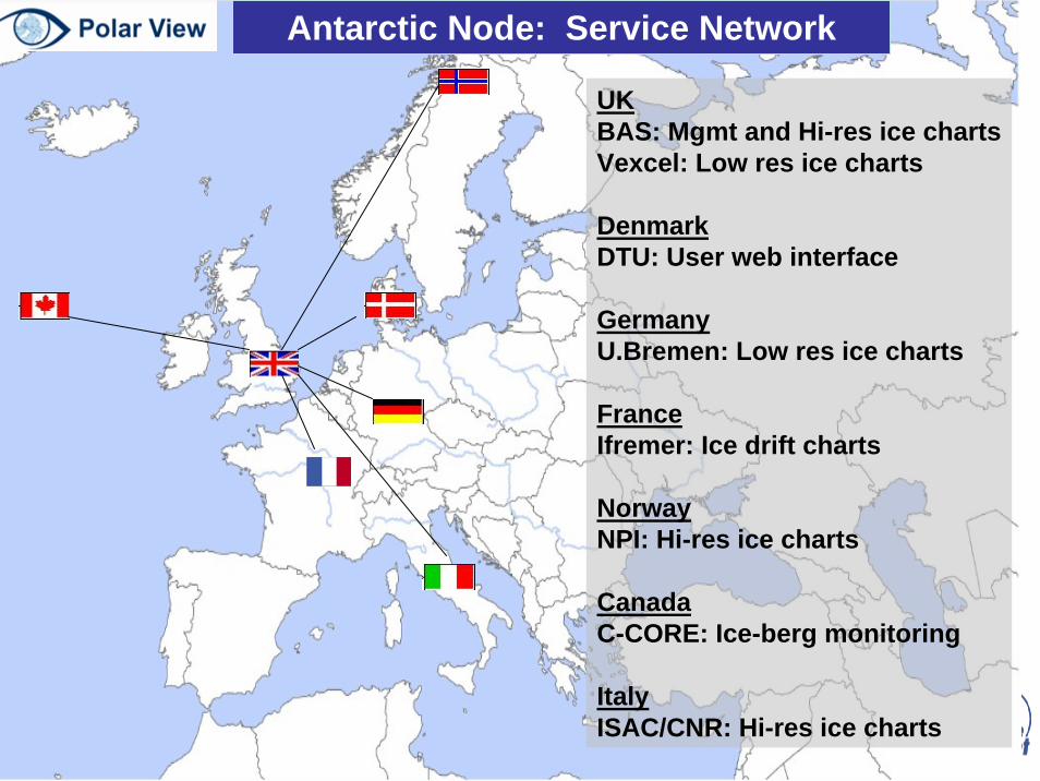
UKBAS: Mgmt and Hi-res ice chartsVexcel: Low res ice charts
DenmarkDTU: User web interface
GermanyU.Bremen: Low res ice charts
FranceIfremer: Ice drift charts
NorwayNPI: Hi-res ice charts
CanadaC-CORE: Ice-berg monitoring
ItalyISAC/CNR: Hi-res ice charts
Antarctic Node: Service Network

22 Service Level Agreements placed with user organisations (France 4, Italy 4, Spain 4, Germany 4, Sweden 2, Bulgaria 1, Slovakia 1, International 1)
ItalyARPA PiemonteDPC SiciliaDPC BasilicataDPC SavonaDPC TuscanyDPC Lazio
SwedenSRSA with Ljungan municipalitySRSA with Helge municipality
BulgariaMinistry ofEnvironment
SlovakiaDanube Water ManagementAuthority
Germany5 LandkreisWeser river
FranceEMZ East Defense ZoneEMZ West Defense ZoneEMZ South Defense Zone
SpainJunta Castilla y LeonJunta ExtremaduraJunta AndaluciaJunta Guadalajara
+ EU25All CHARTER authorized users
Fire & Flood Risk Services Delivery: 2006-2008

Assets Mapping
•Very high resolution mapsf
• human settlements changes in areas prone to forest fire & flood
Burn Scars Mapping
•Yearly maps
•burned areas
•1ha mapping unit,
•damage & fire risk assessment
Flash Flood Early WarningHourly Maps: RResolution 1km2:
risk of excessive runoffrisk of river flooding
Flood Risk Analysis
Flood risk maps based on historical flood events
Flood risk maps based on hydraulic simulations
Flood event databases
Forest Fire Services
Flood Services
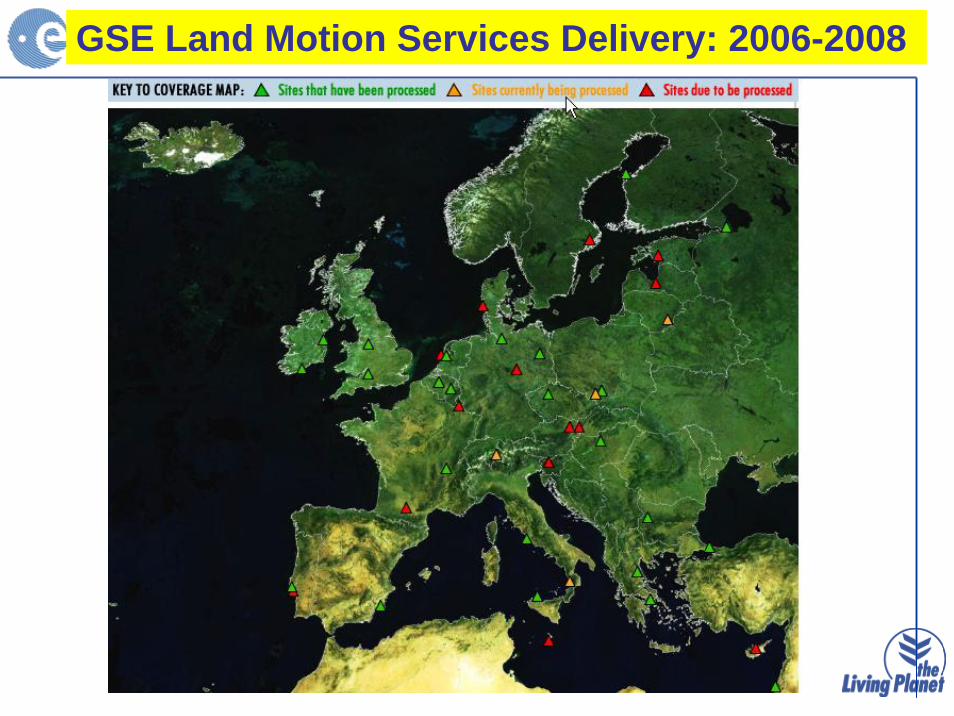
Land Motion Services 2006- 2008GSE Land Motion Services Delivery: 2006-2008

Respond – Service Coverage
Darfur Folio Tsunami Folio
Flood Flood FloodEarthquakeEarthquakeEpidemic
20
Respond Services Delivery: 2003-2006- 2009

www.gse-promote.org
PROMOTE : Air Quality Monitoring & Forecast services
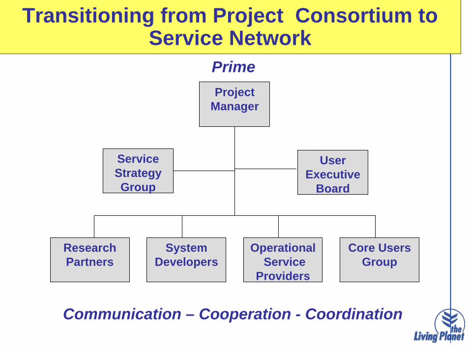
Transitioning from Project Consortium to Service Network
Project
Manager
ResearchPartners
SystemDevelopers
OperationalService
Providers
Core Users Group
ServiceStrategyGroup
Prime
Communication – Cooperation - Coordination
UserExecutive
Board

GSE Service Network ExampleOil Spill
Northern Europe oil spill surveillanceKSAT
Southern Europe oil spill surveillanceTelespazio
Spanish watersStarlab, GTD, GMV
French watersBoost, CLS, CEDRE
Greek watersHCMR
Northern Europe national usersMCA, BfG, NSD, MUMM, SCG, PCG,ECG, SYKE
French user - DAGM
Spanish users - SASEMAR, Puertos del Estados,Port Authorities (Gijon, Barcelona, Vigo)
Greek usersMin Mercantile Marine, Civil Protection
Italian usersMinistero Dell Ambiente, ARPA-Toscana/Liguria
Metocean analysis/forecastMercator, INGV, UK Met Office, Meteo France, Ifremer
Algal bloom alertMUMM
REMPEC
Baltic AISHelcom
MediterraneanAISSASEMAR, ICG, DAGM
Validation BureauBfG, DNV
Oil spill alert, polluter identification
Oil spill alert, polluter identification
Oil spill alert, polluter identification
Oil spill alert, drift forecast
Oil spill alert, polluter identification
Oil spill alert, drift forecast

• GSE Contributions to Fast Track? • Land, Ocean, Emergency, (Atmosphere)
• Core / Downstream paradigm? • Clarity needed
• Currently “Left out and lonely…”?• Ice & Polar services• Food Security• Land motion…
• GSE Services & Networks post 2008/9?
• GMES Service Evolution Study
• What can be declared “Operational” in 2008 ?• Operational vs Sustainable..
GMES Service Issues

GSE contributions to Fast Track Services
Land Fast Track
Service
Marine Fast Track
Service
Emergency Management Fast Track
GSE Land
GSE Forest Monitoring
GSE Flood & Fire
GSE Geo-hazard
GSE Marine & Coastal
GSE Polar
GSE Humanitarian
GSE Food Security
GSE Atmospheric

Layered Service Model
Observations
In-situ / Sentinels / National Missions
Core Services
Pan-European / Global / Generic
Downstream Services
National / Regional / Local / Customized / Localized
CLC 2006Pan-Euro Forest LayerPan-Euro Soil SealingEuropean Urban Atlas
National Land CoverRegional Planning
IrrigationWater Quality
Forest Management
LandsatSPOT / IRS
S-2
LAND
ERS / ENVISAT /RSATT/P - JASON
S-3 & S-1
Oil-Slick Detection/DriftIce Charts
Ocean State Variables NowcastsForecasts
Regional Sea State
HAB Alerts
MARINE
SPOT / HROENVISAT/ RSATVHR Missions
CHARTERS1 & S2
RAPID MAPPING
BASE MAPPING
Crisis MapsDamage Assesmnt Maps
Situation MapsRisk Assessment
EMERGENCY

• Services defined, used and evaluated by users• “Downstream” services…
• Documented traceability of user needs and performance• Service Level Agreements,• Technical Validation, User Utility Reports,
• Demonstrable “Fitness for purpose”• Wrt Policy needs
• Elements that can be declared “operational” in 2008• By users themselves
GSE Service Deliveries 2006 – 2008Contribution to FAST TRACK
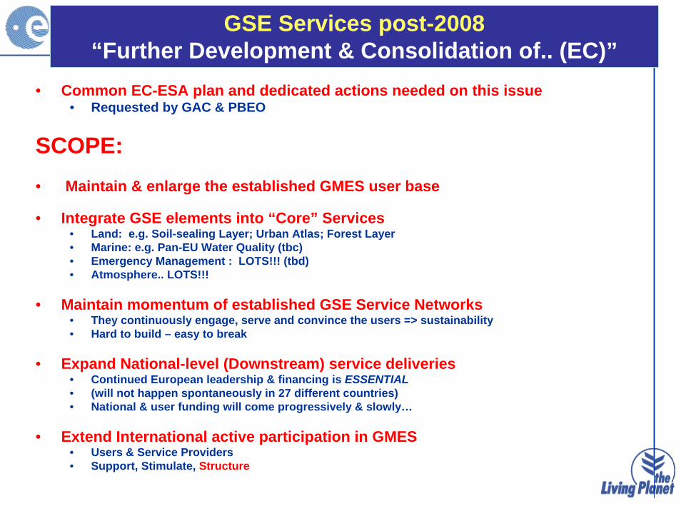
• Common EC-ESA plan and dedicated actions needed on this issue• Requested by GAC & PBEO
SCOPE:• Maintain & enlarge the established GMES user base
• Integrate GSE elements into “Core” Services • Land: e.g. Soil-sealing Layer; Urban Atlas; Forest Layer• Marine: e.g. Pan-EU Water Quality (tbc)• Emergency Management : LOTS!!! (tbd)• Atmosphere.. LOTS!!!
• Maintain momentum of established GSE Service Networks• They continuously engage, serve and convince the users => sustainability• Hard to build – easy to break
• Expand National-level (Downstream) service deliveries• Continued European leadership & financing is ESSENTIAL• (will not happen spontaneously in 27 different countries)• National & user funding will come progressively & slowly…
• Extend International active participation in GMES• Users & Service Providers• Support, Stimulate, Structure
GSE Services post-2008“Further Development & Consolidation of.. (EC)”

• Fast Track/Other Service Implementation plan (7 years)• Needed• Service “Delivery” or “Service Development” ?
• Roles of Industry vs Public institutions in GMES Service provision• Is there an industrial policy ?
• Service Delivery Organization• Monopolies, Cartels, Networks ?
• GMES Service Development Contracts• Statements of Work ? Calls ?
• Management of GMES SLAs• Who is the user ?• Who is the provider? • Who is the Sponsor ?
• Quality Assurance for GMES Services ?• Key issue• Added value of GMES (measurable)
GMES Service Issues
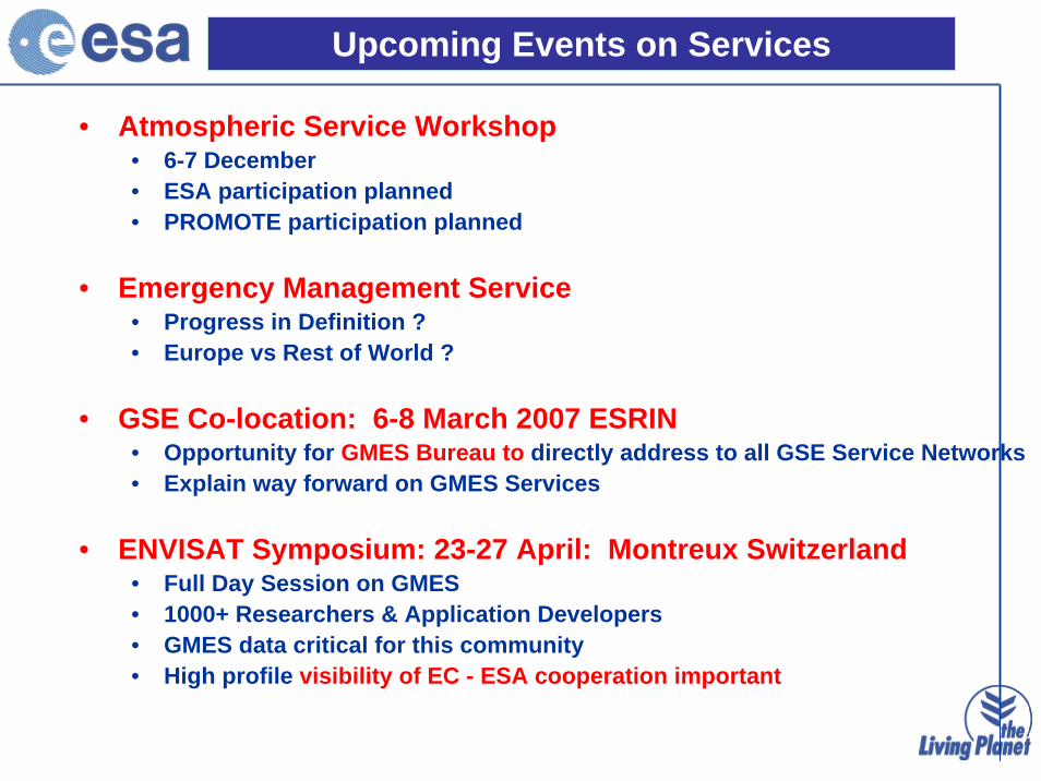
• Atmospheric Service Workshop• 6-7 December• ESA participation planned• PROMOTE participation planned
• Emergency Management Service• Progress in Definition ?• Europe vs Rest of World ?
• GSE Co-location: 6-8 March 2007 ESRIN • Opportunity for GMES Bureau to directly address to all GSE Service Networks• Explain way forward on GMES Services
• ENVISAT Symposium: 23-27 April: Montreux Switzerland • Full Day Session on GMES• 1000+ Researchers & Application Developers• GMES data critical for this community• High profile visibility of EC - ESA cooperation important
Upcoming Events on Services

GMES Services Evolution Study
Scope• Systems Analysis• Service & Users Segment • 1.5 Meuro / 12 months
Main Activities• Analyse services currently under development (GSE, EC FP6, nat)• Specify system requirements for architecture & infrastructure.
Deliverables• Requirements for all aspects implementation of GMES in the next
phase (including service, G/S & Space components),• Scenarios for service delivery with focus on EO components,• Conditions for evolution of services to operational status,• basic requirements (in longer term) for the overall architectural
structure of the GMES implementation.

Briefing Pack on GMES
Citizen
Dossiers : issues & implications for GMES services
2015 Services Portfolio
Implementation Action Plan
Services Roll-out Road Map
3. Bring New Perspectives
2. Initial systemdesigns (4 services)
4. Future Vision
1. Review current GMES services capabilities & status Civilian Risk
Land Cover Monitoring
Marine & Coastal Monitoring
Humanitarian Aid
Global Change Industry Strategi
cSecurity Technolog
y Services Architecture & Implementation requirements
Services segment Operational scenarios
Study Logic