Gloucestershire Emerging New Minerals Plan · village of Clearwell and just east of the hamlet of...
29
Gloucestershire Emerging New Minerals Plan Hydrogeological Assessment - Clearwell/Stowe Hill Gloucestershire County Council May 2016
Transcript of Gloucestershire Emerging New Minerals Plan · village of Clearwell and just east of the hamlet of...
Gloucestershire Emerging New Minerals Plan Hydrogeological Assessment - Clearwell/Stowe Hill Gloucestershire County Council
May 2016
Gloucestershire Emerging New Minerals Plan Hydrogeological Assessment - Clearwell/Stowe Hill
Atkins Hydrogeological Assessment - Clearwell/Stowe Hill | Revision 0 | 10 March 2016 |
5138628 ii
Notice
This document and its contents have been prepared and are intended solely for Gloucestershire County Council’s information and use in relation to the proposed minerals plan.
Atkins Limited assumes no responsibility to any other party in respect of or arising out of or in connection with this document and/or its contents.
This document has 28 pages including the cover.
Document history
Job number: 5138628 Document ref:
Revision Purpose description Originated Checked Reviewed Authorised Date
Rev 0 DRAFT SB KI RGM RGM June 2016
Client signoff
Client Gloucestershire County Council
Project Gloucestershire Emerging New Minerals Plan
Document title Hydrogeological Assessment - Clearwell/Stowe Hill
Job no. 5138628
Copy no.
Document reference

Gloucestershire Emerging New Minerals Plan Hydrogeological Assessment - Clearwell/Stowe Hill
Atkins Hydrogeological Assessment - Clearwell/Stowe Hill | Revision 0 | 10 March 2016 |
5138628 iii
Table of contents
Chapter Pages
Executive summary
1. Introduction 1 1.1. Background 1 1.2. Policy and legislative context 1
2. Assessment method 3 2.1. WFD WebTAG methodology 3
3. Baseline conditions 6 3.1. Site option 6 3.2. Surface water and drainage 6 3.3. Flood risk 7 3.4. Geology 8 3.5. Hydrogeology 9 3.6. Land designations 10
4. Hydrogeological and hydrological risk assessment 13 4.1. Review of activities proposed and potential impacts 13 4.2. Receptors 13 4.3. Identification of pathways 13 4.4. Appraisal of magnitude of impact on receptors 14 4.5. Mitigation measures 0 4.6. Residual effects 0
5. Site investigation and monitoring 1
6. Conclusions 2 6.1. Overall 2 6.2. Operation 2 6.3. Restoration 2
7. List of figures 3
Tables Table 2-1 Importance of water feature or resource 3 Table 2-2 Magnitude of potential impacts 4 Table 2-3 Significance of impacts 5 Table 3-1 Surface Water Bodies within 1 km of the site option 7 Table 3-2 Geological units present beneath the site option 8 Table 3-3 Summary of groundwater conditions from borehole data 10 Table 3-4 Summary of surface and groundwater monitoring stations Error! Bookmark not defined. Table 3-5 Groundwater Body WFD Status 10 Table 3-6 Historical Pollution Incidents 11 Table 3-7 Landfills and Historic Landfills 11 Table 3-8 Ecological sites within 1 km of the site option 11 Table 3-9 Type and number of surface water and groundwater abstractions within 1 km of the site option 12 Table 4-1 Sensitive Receptors at Clearwell/ Stowe Hill 13

Gloucestershire Emerging New Minerals Plan Hydrogeological Assessment - Clearwell/Stowe Hill
Atkins Hydrogeological Assessment - Clearwell/Stowe Hill | Revision 0 | 10 March 2016 |
5138628 iv
List of figures Figure 1 General site option location and layout
Figure 2 Detailed site option and parcels, OS mapping.
Figure 3 Surface water bodies and flood zones
Figure 4 Areas susceptible to groundwater flooding
Figure 5 Bedrock geology underlying the site
Figure 6 Designated Sites
Gloucestershire Emerging New Minerals Plan Hydrogeological Assessment - Clearwell/Stowe Hill
Atkins Hydrogeological Assessment - Clearwell/Stowe Hill | Revision 0 | 10 March 2016 |
5138628
Executive summary
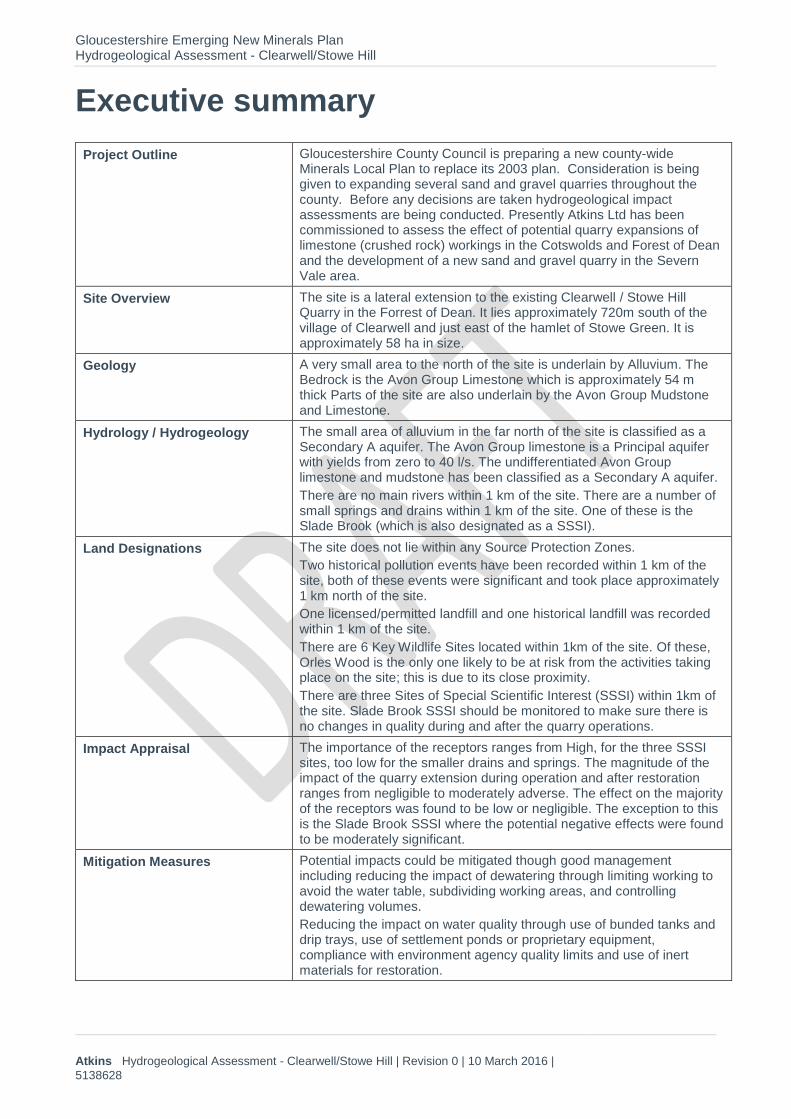
Project Outline Gloucestershire County Council is preparing a new county-wide Minerals Local Plan to replace its 2003 plan. Consideration is being given to expanding several sand and gravel quarries throughout the county. Before any decisions are taken hydrogeological impact assessments are being conducted. Presently Atkins Ltd has been commissioned to assess the effect of potential quarry expansions of limestone (crushed rock) workings in the Cotswolds and Forest of Dean and the development of a new sand and gravel quarry in the Severn Vale area.
Site Overview The site is a lateral extension to the existing Clearwell / Stowe Hill Quarry in the Forrest of Dean. It lies approximately 720m south of the village of Clearwell and just east of the hamlet of Stowe Green. It is approximately 58 ha in size.
Geology A very small area to the north of the site is underlain by Alluvium. The Bedrock is the Avon Group Limestone which is approximately 54 m thick Parts of the site are also underlain by the Avon Group Mudstone and Limestone.
Hydrology / Hydrogeology The small area of alluvium in the far north of the site is classified as a Secondary A aquifer. The Avon Group limestone is a Principal aquifer with yields from zero to 40 l/s. The undifferentiated Avon Group limestone and mudstone has been classified as a Secondary A aquifer.
There are no main rivers within 1 km of the site. There are a number of small springs and drains within 1 km of the site. One of these is the Slade Brook (which is also designated as a SSSI).
Land Designations The site does not lie within any Source Protection Zones.
Two historical pollution events have been recorded within 1 km of the site, both of these events were significant and took place approximately 1 km north of the site.
One licensed/permitted landfill and one historical landfill was recorded within 1 km of the site.
There are 6 Key Wildlife Sites located within 1km of the site. Of these, Orles Wood is the only one likely to be at risk from the activities taking place on the site; this is due to its close proximity.
There are three Sites of Special Scientific Interest (SSSI) within 1km of the site. Slade Brook SSSI should be monitored to make sure there is no changes in quality during and after the quarry operations.
Impact Appraisal The importance of the receptors ranges from High, for the three SSSI sites, too low for the smaller drains and springs. The magnitude of the impact of the quarry extension during operation and after restoration ranges from negligible to moderately adverse. The effect on the majority of the receptors was found to be low or negligible. The exception to this is the Slade Brook SSSI where the potential negative effects were found to be moderately significant.
Mitigation Measures Potential impacts could be mitigated though good management including reducing the impact of dewatering through limiting working to avoid the water table, subdividing working areas, and controlling dewatering volumes.
Reducing the impact on water quality through use of bunded tanks and drip trays, use of settlement ponds or proprietary equipment, compliance with environment agency quality limits and use of inert materials for restoration.

Gloucestershire Emerging New Minerals Plan Hydrogeological Assessment - Clearwell/Stowe Hill
Atkins Hydrogeological Assessment - Clearwell/Stowe Hill | Revision 0 | 10 March 2016 |
5138628 i
Reducing flood risk through placing infrastructure outside areas at risk of flooding, when storing materials in a flood risk area is necessary store materials in the areas with the lowest flood risk, provide flow balancing by use of sustainable urban drainage systems and provide a safe pathway for groundwater to move through the infilled site.
Continue monitoring the Slade Brook SSSI to assess the impact the extension of the quarry has on this waterbody so that any negative impacts can be quickly identified and mitigated.
Site Investigation and monitoring recommendations
It is considered that water quality and water levels monitoring of Slade Brook, along with the groundwater in the bedrock aquifer should be monitored to ensure they are not unduly compromised or affected during the development.
Conclusions Although there is an increased risk of flooding should further mineral extraction take place the mitigation measures set out in this report can be taken to reduce the significance of these impacts from major to minor.

Gloucestershire Emerging New Minerals Plan Hydrogeological Assessment - Clearwell/Stowe Hill
Atkins Hydrogeological Assessment - Clearwell/Stowe Hill | Revision 0 | 10 March 2016 |
5138628 1
1. Introduction
1.1. Background Gloucestershire County Council (herein referred to as “the County Council”) is the Mineral Local Planning Authority (MPA) for the entirety of Gloucestershire. The County Council is preparing a new county-wide Minerals Local Plan to replace its previously adopted minerals local plan, which has been in place since 2003.
As part of this work, Atkins Limited (Atkins) has been commissioned by the County Council to undertake a review of previous hydrological studies and undertake a hydrogeological assessment concerning a number of potential mineral extraction sites across the Cotswolds, Forest of Dean and Severn Vale mineral resource areas. These sites are described by the County Council as ‘site options’ and are currently under consideration for inclusion within the new county wide minerals local plan.
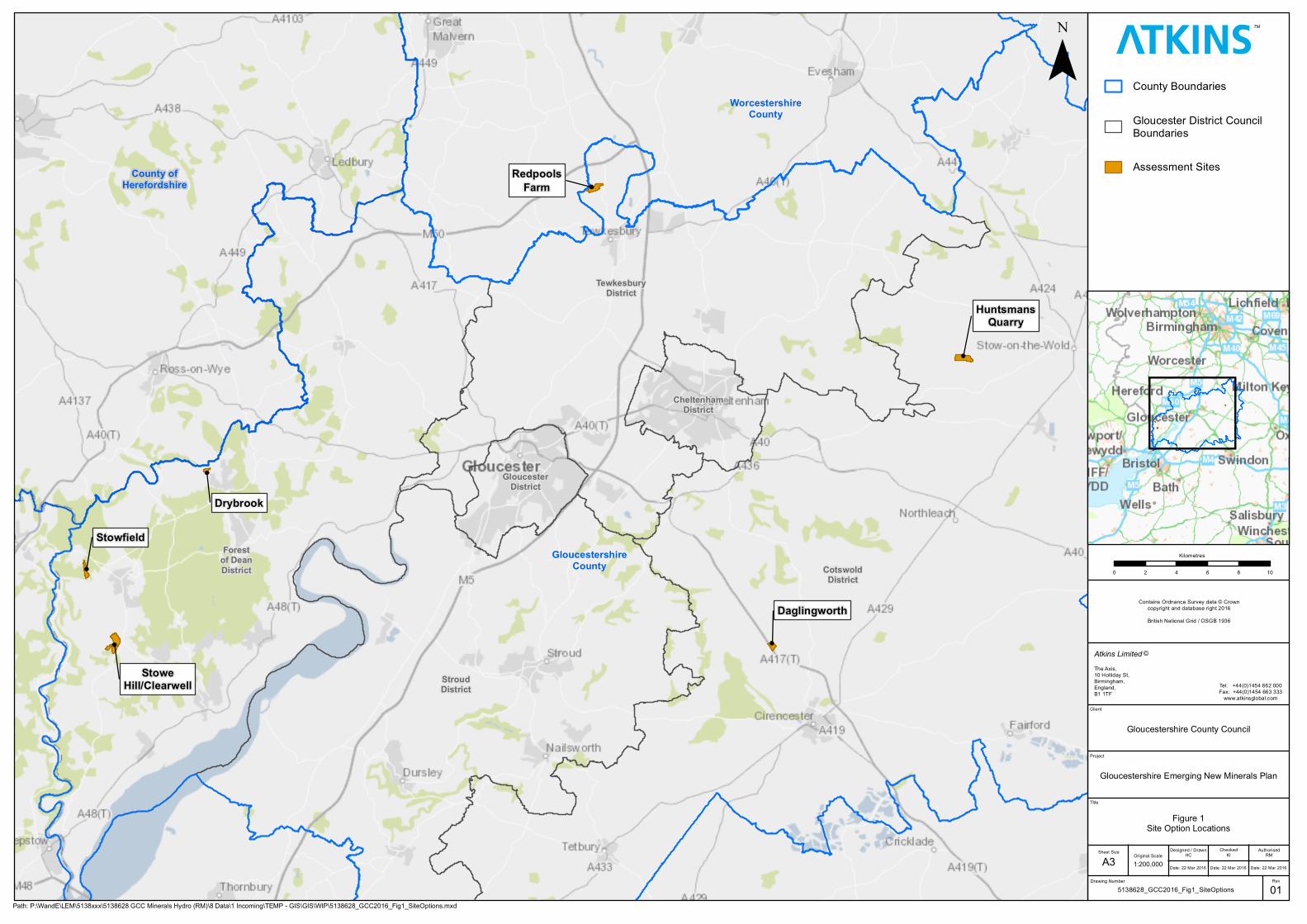
Atkins has completed hydrogeological impact assessments to cover each of the 6 extraction site options under consideration for inclusion within a new county wide minerals local plan. This equates to 5 quarries to extract crushed rock (limestone) and one for sand and gravels (see Figure 1 for the site option locations).
This report provides an appraisal and utilisation of existing local evidence, much of which has been provided by the County Council. This includes water resources information that has been submitted to accompany mineral planning applications, which are either likely to have an influence or encompass the areas identified as site options, and technical work in support of other environmental strategies, plans and proposals.
1.2. Policy and legislative context This initial hydrogeological assessment will be carried out line with the statutory and non-statutory guidance set out in the national, regional and local plans below:
EU Legislation:
Water Framework Directive (WFD)1
The Groundwater Directive (2006/118/EC)2.
UK legislation:
Town and Country Planning Act 1990 (as amended)
The Environmental Permitting (England and Wales) Regulations 2010 (as amended)
Floods and Water Management Act, 2010.
National policy:
Groundwater Protection: Policy and Practice (GP3)3
Catchment Flood Management Plans
The National Planning Policy Framework (NPPF)4 published in March 2012
The Planning Practice Guidance to the NPPF5.
1 Directive 2000/60/EC of the European Parliament and of the Council of 23 October 2000 establishing a framework for
Community action in the field of water policy. Strasbourg, European Parliament and European Council. 2 Directive 2006/118/EC of the European Parliament and of the Council of 12 December 2006 on the protection of groundwater against pollution and deterioration 3 Environment Agency, 2015. Groundwater protection: Principles and practice (GP3) [online] Available at https://www.gov.uk/government/publications/groundwater-protection-principles-and-practice-gp3 [Accessed 19 February 2015] 4 Department of Communities and Local Government, 2012. National Planning Policy Framework. DCLG, London. 5 Department of Communities and Local Government, n.d. Planning Practice Guidance [Online. Available at: http://planningguidance.planningportal.gov.uk/. Accessed on 27th March 2015.

Gloucestershire Emerging New Minerals Plan Hydrogeological Assessment - Clearwell/Stowe Hill
Atkins Hydrogeological Assessment - Clearwell/Stowe Hill | Revision 0 | 10 March 2016 |
5138628 2
Local policy:
Gloucestershire Waste Core Strategy6
Gloucestershire Revised Minerals and Waste Development Scheme (MWDS)7
6 Gloucestershire County Council, 2012. Gloucestershire Waste Core Strategy (WCS). Adopted 21st November 2012. 7 Gloucestershire County Council, 2013. Revised Minerals and Waste Development Scheme, 2013-2016.

Gloucestershire Emerging New Minerals Plan Hydrogeological Assessment - Clearwell/Stowe Hill
Atkins Hydrogeological Assessment - Clearwell/Stowe Hill | Revision 0 | 10 March 2016 |
5138628 3
2. Assessment method
2.1. WebTAG methodology Assessment criteria have been used based on the methodology for appraising the impact of projects (plan level appraisal) set out in the Department for Transport’s (DfT) Transport Analysis Guidance (TAG) Unit A3 Environmental Impact Appraisal8 and the specific guidance for the water environment sub-objective set out in TAG Unit 10.2 (10.2.12 Impact Appraisal)9. Although this methodology has been developed for the assessment of road and bridge projects it can be used to assess the impacts of other developments such as the proposed mineral extraction sites.
The methodology takes into account the importance of the feature (Table 2-1), magnitude and significance of predicted impacts on the water environment (Table 2-2).
The severity of a specific potential effect is then derived by considering both the importance (or sensitivity) of the feature and the magnitude of the impact (impacts must be quantified where possible, also estimating the change from the baseline conditions and the range of uncertainty). The significance of the effects must be identified. This has been addressed in the derivation of significance of potential effects matrix shown in Table 2-3 which gives the significance of effect as a function of the sensitivity of the receptor and magnitude of impact.
Table 2-1 Importance of water feature or resource
Importance Criteria Examples
Very High Feature with a high quality and rarity, regional or national scale and limited potential for substitution.
Aquifer providing potable water to a large population (Groundwater).
Important fish population (Surface water).
Floodplain or defence protecting more than 100 residential properties (Flood Risk).
High Feature with a high quality and rarity, local scale and limited potential for substitution.
Feature with a medium quality and rarity, regional or national scale and limited potential for substitution.
Water Framework Directive (WFD) “High” status water body (Surface water).
Aquifer providing potable water to a small population (Groundwater).
Notable fish population (Surface water).
Floodplain or defence protecting up to 10 industrial premises (Flood risk).
Medium Feature with a medium quality and rarity, local scale and limited potential for substitution.
Feature with a low quality and rarity, regional or national scale and limited potential for substitution.
WFD “Good” status water body (Surface water).
Aquifer providing abstraction water for agricultural or industrial use (Groundwater).
Floodplain or defence protecting up to 10 industrial premises (Flood risk).
Low Feature with a low quality and rarity, local scale and
WFD “Less than good” status (Surface water).
8 Department for Transport, 2014. Environmental Impacts Appraisal. November 2014, Transport Analysis Guidance (TAG 9 Department for Transport, 2014. Environmental Impacts Appraisal. Impacts on the Water Environment, Tag Unit A3 10.2. November 2014, Transport Analysis Guidance (TAG).

Gloucestershire Emerging New Minerals Plan Hydrogeological Assessment - Clearwell/Stowe Hill
Atkins Hydrogeological Assessment - Clearwell/Stowe Hill | Revision 0 | 10 March 2016 |
5138628 4
Importance Criteria Examples
limited potential for substitution.
Unproductive strata (Groundwater).
Floodplain with limited existing development (Flood risk).
Table 2-2 Magnitude of potential impacts
Magnitude Criteria Example
Large Adverse Results in loss of feature Loss of important fishery.
Change in WFD classification of river
reach.
Compromise employment source.
Loss of flood. storage/increased flood
risk
Pollution of potable source of
abstraction.
Moderate Adverse Results in adverse impact on integrity of feature or loss of part of feature.
Loss in productivity of a fishery.
Contribution of a significant proportion
of the effluent in the receiving river,
but deemed insufficient to change its’
WFD classification.
Reduction in the economic value of
the feature.
Slight Adverse Results in minor adverse impact on feature.
Measurable changes in feature, but of
limited size and/or proportion.
Negligible Results in an impact on feature but of insufficient magnitude to affect use/integrity.
Discharges to watercourse but no
significant loss in quality, fishery
productivity or biodiversity.
No significant impact on the economic
value of the feature.
No increase in flood risk.
Slight beneficial Results in minor beneficial impact on feature or a reduced risk of adverse effect occurring.
Measurable changes in feature, but of
limited size and/or proportion.

Gloucestershire Emerging New Minerals Plan Hydrogeological Assessment - Clearwell/Stowe Hill
Atkins Hydrogeological Assessment - Clearwell/Stowe Hill | Revision 0 | 10 March 2016 |
5138628 5
Moderate beneficial Results in moderate improvement of feature
Enhanced productivity of a fishery.
Reduction in a significant proportion of
the effluent in a receiving river, but not
sufficient to change its WFD
classification.
Moderate reduction in flood risk.
Large beneficial Results in major improvement of feature
Removal of major existing polluting
discharge to a watercourse.
Major reduction in flood risk.
Table 2-3 Significance of impacts
Magnitude of potential impact
Importance / Sensitivity of attribute
Very high High Medium Low
Large Adverse Very Significant Highly Significant Significant Low Significance
Moderate Adverse Highly Significant Significant Low Significance Insignificant
Slight Adverse Significant Low Significance Insignificant Insignificant
Negligible Low Significance Insignificant Insignificant Insignificant
In applying this methodology to both construction and operational stages, significant effects would be those of low significance or above. If an adverse significant effect is identified then potential mitigation measures have been developed to reduce or mitigate this effect. When beneficial impacts are identified, then opportunities for further environmental enhancement can be considered.
Gloucestershire Emerging New Minerals Plan Hydrogeological Assessment - Clearwell/Stowe Hill
Atkins Hydrogeological Assessment - Clearwell/Stowe Hill | Revision 0 | 10 March 2016 |
5138628 6
3. Baseline conditions
3.1. Site option The site option lies between the village of St. Briavels (1.8 km south west), and the village of Clearwell (720 m north) just east of the hamlet of Stowe Green and west of the Hamlet of Trow Green within the Forest of Dean Area of Outstanding National Beauty (AONB). The site has an approximate National Grid Reference of 357531, 206726. An overview plan of the site options is provided in Figure 1.
The site option is approximately 58 ha in size and is a lateral extension to the existing Stowe Hill/ Clearwell quarry. The current land use within the site option is a mixture of arable and grazing farmland. There is an existing farm building located to the east of the site which is part of Longley Farm. A detailed plan of the site option, with parcel outlines is provided on Figure 2.
The B4228 runs along the eastern extent of the site option, Clearwell Road runs along the northern extent. To the south the site is bordered by a forested area which is labelled as Bearse Common on the OS map. The existing Stowfield/Clearwell quarry bounds the site option to the west.
OS mapped topography indicates that the highest point on the site option is at 197 mAOD, near to the forested area towards the south of the site. The site slopes down to the north east towards Trowgreen Farm and to the south towards Slade Brook.
3.2. Surface water and drainage The surface water bodies within 1 km of the site, and their associated flood zones, are presented on Figure 3 and details of the main rivers, watercourses and rivers are presented within table 3-2.
3.2.1. Main rivers There are no main rivers within 1 km of the site option. The closest main rivers are the River Wye, approximately 2.5 km west of the site option.
3.2.2. Ordinary watercourses (Lead local flood authority) No watercourses are mapped within the site option, however within 1 km of the site option there are numerous watercourses shown on Ordnance Survey (OS) mapping. There is a small unnamed spring at the north border of the site. A tributary of Oakwood Brook is approximately 204 m east of the site, and a second tributary of this brook lies 703 m east of the site. A small spring is mapped 750 m south of the site and this spring flows into Slade Brook which is 890 m south of the site option. A small unnamed spring is marked immediately north of Clearwell Road, approximately 10 m north of the site boundary and a second unnamed spring is located approximately 868 m north of the site near Clearwell. The Valley Brook which is 2.5 km north west of the site option and the Cannop Brook is approximately 3.8 km east of the site.
3.2.3. Lakes and ponds No lakes or ponds are indicated within the site option on OS or satellite mapping. Noxton Pond lies approximately 500 m east of the site option. There are four small ponds in the southern section of the existing quarry. There are also three very small ponds in the southern section of the site, these are likely to be temporary water features associated with the quarry workings. These can be seen on the OS map provided in Figure 3.
3.2.4. Monitoring locations and groundwater flow The Centre of Ecology and Hydrology (CEH)10 have a number of surface water monitoring points throughout the UK. None of these are located within 1 km of the site option. The closest station is on the River Wye at Cadora in Wales, approximately 3.65 km to the north west of the site option. The available CEH monitoring stations are summarised in Error! Reference source not found. below
10 Centre for Hydrology and Ecology & British Geological Survey, 2008. UK Hydrometric Register

Gloucestershire Emerging New Minerals Plan Hydrogeological Assessment - Clearwell/Stowe Hill
Atkins Hydrogeological Assessment - Clearwell/Stowe Hill | Revision 0 | 10 March 2016 |
5138628 7
Table 3-1 Summary of surface water monitoring stations
Surface water monitoring station
Grid reference Area covered (km2)
Mean flow (m3/s)
Wye at Cadora
(Ref: 55001)
SO535090 4040 n/a
Cannop Brook at Parkend
(Ref: 54084)
SO616075 31.5 0.324
3.2.5. Water Framework Directive status
Table 3-2 Surface Water Bodies within 1 km of the site option
Water body name / ID
Location (NGR) Hydromorpho-logical status
Current ecological quality
(Certainty)
Current chemical quality
(Certainty)
Value/ Importance
Valley Brook – source to conf R Wye
(GB109055029670)
Moderate Good Good by 2027 Good by 2015 Probably at risk
Warth Brook – source to River Severn Estuary
(GB109054032530)
Moderate Good Good by 2027 Good by 2015 Probably at risk
Cannop Brook – source to River Severn Estuary
(GB109054032640)
Moderate Good Good by 2027 Good by 2015 Probably at risk
Source: The Environment Agency, 2015. WFD Cycle 2 Groundwater Body Classifications and Objectiveshttps://ea.sharefile.com/share?cmd=d&id=s0c6fa39b82a46e9a#/view/s0c6fa39b82a46e9a?_k=zbz7l8 Accessed on 17 February 2016
3.3. Flood risk This section summarises the relevant data on flooding that is available for the site option.
3.3.1. Surface water flooding Along the most south westerly boundary, the Environment Agency (EA)11 has highlighted a high to low risk from surface water flooding. This means the area is at risk from events with an annual probability of occurrence up to 3.3%.
11 Environment Agency, March 2016. Risk of Flooding from Surface Water [online] Available at: http://apps.environment-
agency.gov.uk/wiyby/. Accessed on the 7th of March 2016.

Gloucestershire Emerging New Minerals Plan Hydrogeological Assessment - Clearwell/Stowe Hill
Atkins Hydrogeological Assessment - Clearwell/Stowe Hill | Revision 0 | 10 March 2016 |
5138628 8
3.3.2. River flooding No Environment Agency flood zones exist within 1 km of the site option boundary, as mapped by the Environment Agency flooding from rivers and the sea map12 (Figure 3).
3.3.3. Groundwater flooding No information on the probability of groundwater flooding occurring is available, however information on the areas susceptible to groundwater flooding has been provided by the Environment Agency. As indicated on Figure 4, the majority of the site option is within an area where less than 25% of a 1 km grid square is susceptible to groundwater flooding13.
3.3.4. Sewer flooding As the site option is in a rural area and it is unlikely that significant discharges to sewers will be required, sewer flooding has not been considered.
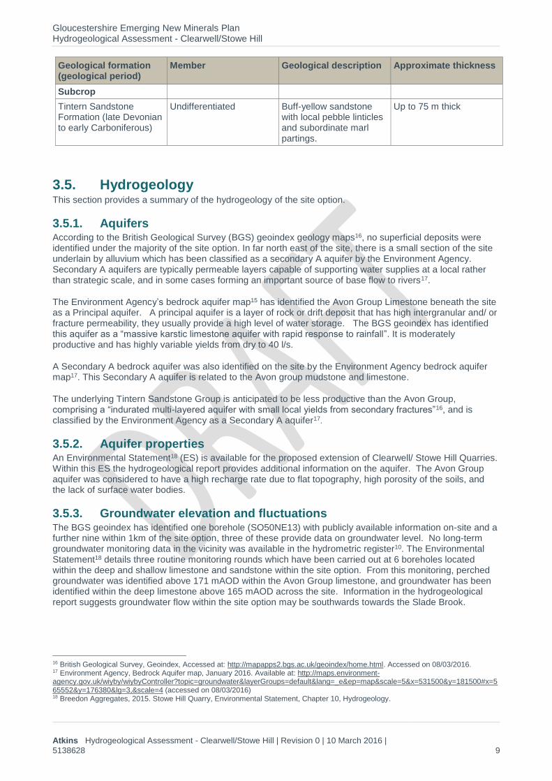
3.4. Geology This section provides a summary of the geology that underlies the site option. Based on information available in the BGS geoindex14, and information made available from the recent Planning Statement site investigation15 the geological units that are present beneath the site have been listed within Table 3-3. Borehole drilling during site investigations discovered the site option to be underlain by a laterally continuous, clean limestone deposit 8-12 m thick, overlying a shale band 0.7-3 m thick. Beneath the shale band, interbedded limestones and shales dominate. The interface between the Avon Group and Tintern Sandstone Group is identified ranging from 164 – 148 mAOD (21-39 mbgl)15.
Plans showing the bedrock geology underlying the site are provided in Figure 5.
Table 3-3 Geological units present beneath the site option
Geological formation (geological period)
Member Geological description Approximate thickness
Superficial deposits
Alluvium
(Flandrian age)
Undifferentiated Soft to firm consolidated, compressible silty clay.
N/A
Bedrock
Avon group – Limestone
(Courceyan Substage)
Undifferentiated Interbedded grey mudstone and thin to medium bedded skeletal packstones with one to several thick units of ooidal and skeletal grainstones.
Approximately 54 m
Avon Group - Mudstone and limestone interbedded
(Courceyan Substage)
Undifferentiated Interbedded grey mudstone and thin to medium bedded skeletal packstones with one to several thick units of ooidal and skeletal grainstones.
Approximately 54 m
12 Environment Agency, March 2016. Flood Map for Planning (Rivers and Sea) [Online]. Available at: http://maps.environment-agency.gov.uk/wiyby/. Accessed on 7th March 2016. 13 Environment Agency, 2015. Areas susceptible to Groundwater Flooding [GIS shapefile]. 14 British Geological Survey, Geoindex. Accessed at: http://mapapps2.bgs.ac.uk/geoindex/home.html. Accessed on 08/03/2016 15 Breedon Aggregates, 2015. Stowe Hill Quarry Extension Planning Statement. Appendix 1 – Site Investigation and
Geological Report.
Gloucestershire Emerging New Minerals Plan Hydrogeological Assessment - Clearwell/Stowe Hill
Atkins Hydrogeological Assessment - Clearwell/Stowe Hill | Revision 0 | 10 March 2016 |
5138628 9
Geological formation (geological period)
Member Geological description Approximate thickness
Subcrop
Tintern Sandstone Formation (late Devonian to early Carboniferous)
Undifferentiated Buff-yellow sandstone with local pebble linticles and subordinate marl partings.
Up to 75 m thick
3.5. Hydrogeology This section provides a summary of the hydrogeology of the site option.
3.5.1. Aquifers According to the British Geological Survey (BGS) geoindex geology maps16, no superficial deposits were identified under the majority of the site option. In far north east of the site, there is a small section of the site underlain by alluvium which has been classified as a secondary A aquifer by the Environment Agency. Secondary A aquifers are typically permeable layers capable of supporting water supplies at a local rather than strategic scale, and in some cases forming an important source of base flow to rivers17.
The Environment Agency’s bedrock aquifer map15 has identified the Avon Group Limestone beneath the site as a Principal aquifer. A principal aquifer is a layer of rock or drift deposit that has high intergranular and/ or fracture permeability, they usually provide a high level of water storage. The BGS geoindex has identified this aquifer as a “massive karstic limestone aquifer with rapid response to rainfall”. It is moderately productive and has highly variable yields from dry to 40 l/s.
A Secondary A bedrock aquifer was also identified on the site by the Environment Agency bedrock aquifer map17. This Secondary A aquifer is related to the Avon group mudstone and limestone.
The underlying Tintern Sandstone Group is anticipated to be less productive than the Avon Group, comprising a “indurated multi-layered aquifer with small local yields from secondary fractures”16, and is classified by the Environment Agency as a Secondary A aquifer17.
3.5.2. Aquifer properties An Environmental Statement18 (ES) is available for the proposed extension of Clearwell/ Stowe Hill Quarries. Within this ES the hydrogeological report provides additional information on the aquifer. The Avon Group aquifer was considered to have a high recharge rate due to flat topography, high porosity of the soils, and the lack of surface water bodies.
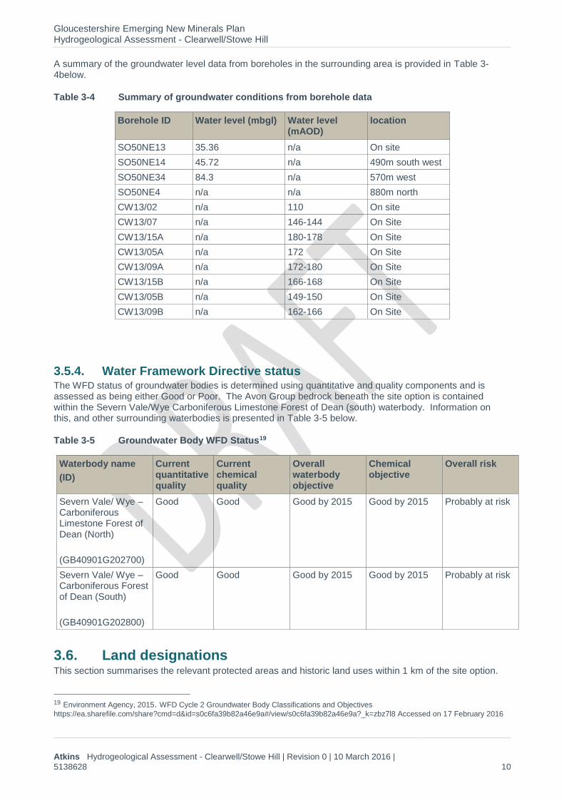
3.5.3. Groundwater elevation and fluctuations The BGS geoindex has identified one borehole (SO50NE13) with publicly available information on-site and a further nine within 1km of the site option, three of these provide data on groundwater level. No long-term groundwater monitoring data in the vicinity was available in the hydrometric register10. The Environmental Statement18 details three routine monitoring rounds which have been carried out at 6 boreholes located within the deep and shallow limestone and sandstone within the site option. From this monitoring, perched groundwater was identified above 171 mAOD within the Avon Group limestone, and groundwater has been identified within the deep limestone above 165 mAOD across the site. Information in the hydrogeological report suggests groundwater flow within the site option may be southwards towards the Slade Brook.
16 British Geological Survey, Geoindex, Accessed at: http://mapapps2.bgs.ac.uk/geoindex/home.html. Accessed on 08/03/2016. 17 Environment Agency, Bedrock Aquifer map, January 2016. Available at: http://maps.environment-agency.gov.uk/wiyby/wiybyController?topic=groundwater&layerGroups=default&lang=_e&ep=map&scale=5&x=531500&y=181500#x=565552&y=176380&lg=3,&scale=4 (accessed on 08/03/2016) 18 Breedon Aggregates, 2015. Stowe Hill Quarry, Environmental Statement, Chapter 10, Hydrogeology.
Gloucestershire Emerging New Minerals Plan Hydrogeological Assessment - Clearwell/Stowe Hill
Atkins Hydrogeological Assessment - Clearwell/Stowe Hill | Revision 0 | 10 March 2016 |
5138628 10
A summary of the groundwater level data from boreholes in the surrounding area is provided in Table 3-4below.
Table 3-4 Summary of groundwater conditions from borehole data
Borehole ID Water level (mbgl) Water level (mAOD)
location
SO50NE13 35.36 n/a On site
SO50NE14 45.72 n/a 490m south west
SO50NE34 84.3 n/a 570m west
SO50NE4 n/a n/a 880m north
CW13/02 n/a 110 On site
CW13/07 n/a 146-144 On Site
CW13/15A n/a 180-178 On Site
CW13/05A n/a 172 On Site
CW13/09A n/a 172-180 On Site
CW13/15B n/a 166-168 On Site
CW13/05B n/a 149-150 On Site
CW13/09B n/a 162-166 On Site
3.5.4. Water Framework Directive status The WFD status of groundwater bodies is determined using quantitative and quality components and is assessed as being either Good or Poor. The Avon Group bedrock beneath the site option is contained within the Severn Vale/Wye Carboniferous Limestone Forest of Dean (south) waterbody. Information on this, and other surrounding waterbodies is presented in Table 3-5 below.
Table 3-5 Groundwater Body WFD Status19
Waterbody name
(ID)
Current quantitative quality
Current chemical quality
Overall waterbody objective
Chemical objective
Overall risk
Severn Vale/ Wye – Carboniferous Limestone Forest of Dean (North)
(GB40901G202700)
Good Good Good by 2015 Good by 2015 Probably at risk
Severn Vale/ Wye – Carboniferous Forest of Dean (South)
(GB40901G202800)
Good Good Good by 2015 Good by 2015 Probably at risk
3.6. Land designations This section summarises the relevant protected areas and historic land uses within 1 km of the site option.
19 Environment Agency, 2015. WFD Cycle 2 Groundwater Body Classifications and Objectives
https://ea.sharefile.com/share?cmd=d&id=s0c6fa39b82a46e9a#/view/s0c6fa39b82a46e9a?_k=zbz7l8 Accessed on 17 February 2016
Gloucestershire Emerging New Minerals Plan Hydrogeological Assessment - Clearwell/Stowe Hill
Atkins Hydrogeological Assessment - Clearwell/Stowe Hill | Revision 0 | 10 March 2016 |
5138628 11
3.6.1. Source protection zones According to Environment Agency groundwater mapping, the site option does not lie within a groundwater Source Protection Zone20.
3.6.2. Historical land use and pollution incidents No pollution incidents were recorded on the site option, however two significant incidents were recorded by the Environment Agency approximately 1 km north east of the site at the New Dunn Works21. Details of these incidents are provided in Table 3-6. No impacts to water were recorded as a result of either incident.
Table 3-6 Historical Pollution Incidents
Date Approximate NGR Environmental impact
Incident number Pollutant
30/07/2015 SO5823308389 Significant 1359767 Other Pollutant
04/06/2014 SO5835908544 Significant 1242010 Inert materials and wastes
Specific wastes materials
According to the Environment Agency landfill mapping22 there is one licensed/permitted landfill and one historical landfill recorded within 1 km from the site (Table 3-7). Clay Woods Landfill is approximately 850 m north east of the site, this landfill took non-biodegradable wastes but its licence has now expired. The Fountain is a historical landfill located approximately 600 m north of the site option.
Table 3-7 Landfills and Historic Landfills
Landfill name Approximate NGR and distance from site option
Licence status Waste management licence number
IPPC reference number
Clay Woods Landfill SO5830608364 Expired 48190 EAEPR\EA/EPR/LP3698CG/A001
The Fountain SO5815807576 N/A N/A N/A
3.6.3. Protected areas According to information provided by Natural England23 and Magic Mapping24 the site lies within a Site of Special Scientific Interest (SSSI) impact zone and there are three SSSIs located within 1 km of the site option. These SSSIs, as well as Key Wildlife Sites, have been detailed in Table 3-8 below and are presented in Figure 6.
Table 3-8 Ecological sites within 1 km of the site option
20Environment Agency, Groundwater interactive map, January 2016. Accessed at: http://maps.environment-
agency.gov.uk/wiyby/wiybyController?topic=groundwater&layerGroups=default&lang=_e&ep=map&scale=4&x=565551.875&y=176380.3125 Accessed on 08/03/2016. 21 Environment Agency, Pollution incidents map, January, 2016. Accessed at: http://maps.environment-agency.gov.uk/wiyby/wiybyController?topic=pollution&layerGroups=default&lang=_e&ep=map&scale=4&x=565551.875&y=176380.3125 . Accessed on 08/03/2016. 22 Environment Agency, Landfills Interactive Map Jan 2016. Accessed at: http://maps.environment-agency.gov.uk/wiyby/wiybyController?topic=waste&layerGroups=default&lang=_e&ep=map&scale=4&x=565551.875&y=176380.3125. Accessed on 08/03/2016 23 KWS shapefiles, Natural England, May 2012 24 MAGIC, MAGIC Mapping Tools (2016), [online] available from: http://www.magic.gov.uk/MagicMap.aspx. Accessed on 17 February 2016

Gloucestershire Emerging New Minerals Plan Hydrogeological Assessment - Clearwell/Stowe Hill
Atkins Hydrogeological Assessment - Clearwell/Stowe Hill | Revision 0 | 10 March 2016 |
5138628 12
Type/ designation Name Location relative to the site option
Value
SSSI Tudor Farm Bank 680 m north High
SSSI Slade Brook 715 m south High
SSSI Old Bow & Old Ham Mines
705 m north High
Key Wildlife Site (KWS) Orles Wood Adjacent to the southern border of the site option
Medium
Key Wildlife Site Slade, Levshill & Slade Bottom Woods
575 m south Medium
Key Wildlife Site Noxton Pond 500 m east Medium
Key Wildlife Site Clearwell Valley 290 m north Medium
Key Wildlife Site Clearwell Meend 705 m north Medium
Key Wildlife Site Clearwell Old Wall 820 m south west Medium
3.6.4. Abstractions According to the Environment Agency interactive map, there are no abstractions present on the site25, all licenced and unlicensed abstractions within 1km of the site have been detailed in the Table 3-9 below.
Table 3-9 Type and number of surface water and groundwater abstractions within 1 km of the site option
WFD water body Name
Location Purpose Max annual abstraction (m3//year)
Maximum daily abstraction / volume (m3/day)
EAW Groundwater 438 m west Dust Suppression 68640 264
Details of private (unlicensed) supplies have been supplied by the relevant environmental health department, one potable water supply was identified 2 km north west of the site. The supply is for 1 domestic property and therefore the volume of water abstracted is likely to be low26.
25 Environment Agency, Water Abstraction Licences Interactive map, Jan 2016. Available at: http://maps.environment-
agency.gov.uk/wiyby/wiybyController?topic=water_abstractions&layerGroups=default&lang=_e&ep=map&scale=4&x=565551.875&y=176380.3125. Accessed on 08/03/2016 26 Forest of Dean County Council, March 2016, Pers. Comm.
Gloucestershire Emerging New Minerals Plan Hydrogeological Assessment - Clearwell/Stowe Hill
Atkins Hydrogeological Assessment - Clearwell/Stowe Hill | Revision 0 | 10 March 2016 |
5138628 13
4. Hydrogeological and hydrological risk assessment
4.1. Review of activities proposed and potential impacts It is proposed that GCC allocate several sites throughout the county for further mineral extraction and expansion. One of site which is being considered for mineral extraction is the site located at Clearwell/ Stowe Hill quarries. This study aims to carry out a hydrogeological assessment of the site area and examine the risks posed by any future development to specific receptors and the pathways that may cause this risk to affect receptors within the boundary of the proposed development area. For the purposes of this assessment it has been assumed that work has taken place and the quarried areas have been backfilled with clay, therefore this is an assessment of the worst case scenario.
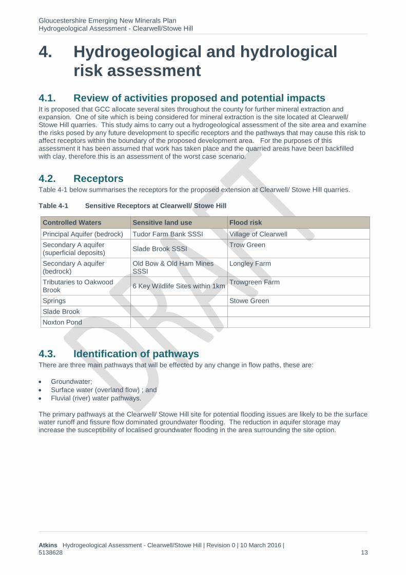
4.2. Receptors Table 4-1 below summarises the receptors for the proposed extension at Clearwell/ Stowe Hill quarries.
Table 4-1 Sensitive Receptors at Clearwell/ Stowe Hill
Controlled Waters Sensitive land use Flood risk
Principal Aquifer (bedrock) Tudor Farm Bank SSSI Village of Clearwell
Secondary A aquifer (superficial deposits)
Slade Brook SSSI Trow Green
Secondary A aquifer (bedrock)
Old Bow & Old Ham Mines SSSI
Longley Farm
Tributaries to Oakwood Brook
6 Key Wildlife Sites within 1km Trowgreen Farm
Springs Stowe Green
Slade Brook
Noxton Pond
4.3. Identification of pathways There are three main pathways that will be effected by any change in flow paths, these are:
Groundwater;
Surface water (overland flow) ; and
Fluvial (river) water pathways.
The primary pathways at the Clearwell/ Stowe Hill site for potential flooding issues are likely to be the surface water runoff and fissure flow dominated groundwater flooding. The reduction in aquifer storage may increase the susceptibility of localised groundwater flooding in the area surrounding the site option.
Gloucestershire Emerging New Minerals Plan Hydrogeological Assessment - Clearwell/Stowe Hill
Atkins Hydrogeological Assessment - Clearwell/Stowe Hill | Revision 0 | 10 March 2016 |
5138628 14
4.4. Appraisal of magnitude of impact on receptors
Receptor Importance Impact Magnitude Significance
During operation After restoration
Principal Aquifer Medium Potential for de-watering and diversion of groundwater away from this area of the aquifer. Decrease in water quality.
Moderate Adverse
De-watering activities and quarrying are likely to result in a decrease of water levels within the aquifer and have potential to decrease water quality.
Moderate Adverse
Restoration with lower permeability material is likely to decrease the recharge of water to this section of the aquifer and may decrease the water level.
Low Significance
Secondary A aquifer (Bedrock)
Medium Potential for de-watering and diversion of groundwater away from this area of the aquifer. Decrease in water quality.
Moderate Adverse
De-watering activities and quarrying are likely to result in a decrease of water levels within the aquifer and have potential to decrease water quality.
Moderate Adverse
Restoration with lower permeability material is likely to decrease the recharge of water to this section of the aquifer and may decrease the water level.
Low Significance
Secondary A aquifer (Superficial)
Low Potential for de-watering and diversion of groundwater away from this area of the aquifer. Decrease in water quality.
Negligible
De-watering activities and quarrying are likely to result in a decrease of water levels within the aquifer and have potential to decrease water quality.
Negligible
After restoration backfilling of the quarry area with impermeable materials is likely to restrict the flow of water through the aquifer.
Insignificant
Tributaries to Oakwood Brook
(204m)
Low Increase in suspended solids from quarrying activities and a potential for increase in overland flow. Changes to base flow as a result of dewatering and/or inert infill.
Slight Adverse
There may be an increase in suspended sediments in the surface run off due to the nature of the activities taking place on the quarry site. An increase in suspended sediment on the watercourse could lead to a decline in the overall quality of Oakwood Brook. De-watering activities during operations may result in diversion of water from the Slade Brook as groundwater flow paths are interrupted.
Slight Adverse
After the restoration the site is likely to be backfilled with lower permeability materials. This is likely to increase the overland flow into the water course and may cause a reduction in baseflow contribution by producing a barrier to groundwater flow
Insignificant
Gloucestershire Emerging New Minerals Plan Hydrogeological Assessment - Clearwell/Stowe Hill
Atkins Hydrogeological Assessment - Clearwell/Stowe Hill | Revision 0 | 10 March 2016 |
5138628 15
Receptor Importance Impact Magnitude Significance
During operation After restoration
Springs Low Potential for dewatering and reduction of groundwater level.
Slight adverse
Dewatering during the quarry works, may reduce the groundwater level, this could reduce the productivity of the nearby springs.
Slight Adverse
After the restoration the site is likely to be partially backfilled with impermeable materials. This is likely to alter the flow of ground water through the site, which may have an effect on the productivity of the nearby springs.
Insignificant
Slade Brook (SSSI) High Increase in suspended solids from quarrying activities and a potential for increase in overland flow. Changes to base flow as a result of dewatering and/or inert infill.
Potential for changes to carbonate content of groundwater leading to changes to Tufa formation processes.
Moderate Adverse
There may be an increase in suspended sediments in the surface run off due to the nature of the activities taking place on the quarry site. An increase in suspended sediment on the watercourse could lead to a decline in the overall quality.
De-watering activities during operations may result in diversion of water from the Slade Brook as groundwater flow paths are interrupted.
Changes to conservation status of the SSSI as a result of changes to flow or chemistry.
Moderate Adverse
After the restoration the site is likely to be partially backfilled with lower permeability materials. This is likely to increase the overland flow into the water course and may cause a reduction in baseflow contribution by producing a barrier to groundwater flow.
Changes to conservation status of the SSSI as a result of changes to flow or chemistry.
Significant
Noxton Pond Low Quarrying activities have the potential to increase the quantity of suspended solids in overland flow. Increase or decrease in water levels due to groundwater diversion and dewatering.
Slight Adverse
Increase in suspended solids in overland flow may cause an increase in suspended solids into the pond. Suspended solids can increase the turbidity of a water body, decreasing the water quality. However the distance of Noxton Pond from the site (500m) makes it unlikely that the any adverse effects from quarrying occur.
Slight Adverse
After restoration of the quarry area, backfilling with impermeable material may increase the volume of overland flow from the site, this could lead to an increase in the water level of the pond. Additionally the fill may introduce barriers to groundwater flow. The distance of Noxton Pond from the site option makes it unlikely that it will be negatively affected by quarrying activities.
Insignificant
Gloucestershire Emerging New Minerals Plan Hydrogeological Assessment - Clearwell/Stowe Hill
Atkins Hydrogeological Assessment - Clearwell/Stowe Hill | Revision 0 | 10 March 2016 |
5138628 16
Receptor Importance Impact Magnitude Significance
During operation After restoration
Tudor Farm Bank SSSI
High Changes to water availability, reduction in water quality.
Negligible
Tudor Farm SSSI is a calcareous grassland. It is possible that quarrying activities may have an effect on the quantity and quality of groundwater and overland flow to the site. However there is no information that suggests this SSSI is water dependant.
Negligible
After restoration, changes in groundwater and overland flow produced by backfilling with low permeability material have the potential to negatively impact this SSSI, however there is no information that suggests this SSSI is heavily water dependant.
Insignificant
Old Bow & Old Ham Mines SSSI
High Negative affect on Bat population.
Negligible
This SSSI is a known bat habitat. However the distance of this SSSI from the site makes it unlikely that there will be any negative affect on this SSSI.
Negligible
This SSSI is a known bat habitat. However the distance of this SSSI from the site makes it unlikely that there will be any negative affect on this SSSI.
Insignificant
6 Key Wildlife Sites within 1 km
Medium Increase in volume of suspended solids or change in water quality can impact sensitive aquatic wildlife.
Changes in groundwater levels and/or quality can impact sensitive vegetation.
Moderate Adverse
County Council Key Wildlife Sites are designated areas with a rich diversity of habitats that provide refuges and corridors for wildlife across Gloucestershire. Some of which may contain plant species sensitive to groundwater levels, or aquatic life sensitive to changes in water quality. Due to the relative distance of the KWS from the site option, it is considered unlikely that impacts will be felt at any site other than Orles Wood.
Moderate Adverse
The proximity of Orles Wood to the site option indicates the possibility that restoration using low permeability inert fill cause a negative impact due to localised changes in groundwater flow direction. This will need to be confirmed during the details work to support any application.
Low Significance
Flood Risk High Potential for an increase in the risk of flooding from surface water and groundwater.
Moderate Adverse
Dewatering is likely to be required during quarrying and discharge of this water may give rise to an increased risk of flooding if the capacity of the receiving stream is exceeded.
Moderate Adverse
Once that site has been backfilled with impermeable material, it is likely that this will increase surface pooling on the site.
The lower permeability materials are likely to block the migration of groundwater through the site and
Significant

Gloucestershire Emerging New Minerals Plan Hydrogeological Assessment - Clearwell/Stowe Hill
Atkins Hydrogeological Assessment - Clearwell/Stowe Hill | Revision 0 | 10 March 2016 |
5138628 17
Receptor Importance Impact Magnitude Significance
During operation After restoration
Any stockpiling of materials within areas susceptible to surface water flooding may increase the risk of flooding off site due to a reduction in flood plain storage.
therefore water levels may rise upgradient of the site. This may give rise to an increased risk of groundwater flooding locally.

Gloucestershire Emerging New Minerals Plan
Hydrogeological Assessment - Clearwell/Stowe Hill
Atkins Hydrogeological Assessment - Clearwell/Stowe Hill
| Revision 0 | 10 March 2016 | 5138628 0
4.5. Mitigation measures It is recognised that the proposed mineral extraction activities could, absent any mitigation, have various adverse impacts upon the water environment. However, it is anticipated that potential operators would, as part of their applications undertaken detailed site investigations and monitoring and provide a more detailed assessment of the impacts. Where a development is an EIA development this would be presented in the relevant chapter of the Environmental Statement as well as within a flood risk assessment compatible with the requirements of the NPPF. For non-EIA development it is still expected that the effects of the development on the water environment, and especially upon flood risk will be properly considered and documented. Where necessary it is expected that mitigation measures will be detailed within the application to reduce the impacts to acceptable levels.
Mitigation measures to reduce the impact of dewatering are likely to include some or all of:
Limiting working to avoid the water table only to avoid the need for dewatering
Subdivision of the working area into smaller cells to reduce the active perimeter;
Control of dewatering volumes, and if necessary suspension of pumping during storm event, to ensurereceiving waters have appropriate capacity for the flow.
Mitigation measures to reduce impact on water quality are likely to include some or all of:
Use of bunded tanks and drip trays to prevent spillages;
Use of settlement (silt) ponds or proprietary equipment to reduce the silt content of discharged water;
Compliance with quality limits set by the Environment Agency; and
Use of inert materials only for restoration.
Measures to minimise the impact of flood risk are likely to include some or all of:
Placing buildings, stockpiles and other infrastructure outside areas at risk of surface water floodingwhere ever possible;
Where storage within a flood risk areas is required, place it at as low a risk as possible, which willcommonly be as close to the edge of the zone as possible;
Provide flow balancing using sustainable drainage systems such that the greenfield (pre-development)rate of runoff is not exceeded in line with current SuDS guidance; and
Provide safe pathways for groundwater to move around or through the infilled site such the groundwaterlevels do not rise above the pre-development levels.
Slade Brook SSSI could be impacted by changes to flow or to the carbonate balance of the groundwater which could then impact the tufa formation which is the main interest feature. It is noted that extensive work, including flow and chemical monitoring, has been completed to assess the impact of the existing quarry on the brook. Reports have been submitted as part of an Environmental Statement15 which purport to show that the quarry is not adversely affecting the conservation status of the SSSI. A high level of assessment, including careful consideration of the water balance and any changes to water quality will be required as will on ongoing monitoring programme.
4.6. Residual effects If mitigation measures are implemented with the addition of a stringent monitoring programme, the residual effects of the mineral extraction activities at the Site located at Clearwell/ Stowe Hill should be negligible.
Gloucestershire Emerging New Minerals Plan
Hydrogeological Assessment - Clearwell/Stowe Hill
Atkins Hydrogeological Assessment - Clearwell/Stowe Hill
| Revision 0 | 10 March 2016 | 5138628 1
5. Site investigation and monitoring
It is recommended that the following parameters be monitored before, during and after quarry operations:
• Groundwater levels – Monthly monitoring for a period of 12 months prior to quarrying duringoperation (at a higher frequency if required) and during the aftercare and management period.Locations should be identified to provide good overage of the proposed site, taking into account theneed to understand groundwater/surface water interaction and should as far as possible be locatedso that they can function for the whole of the period required.
• Precipitation – Data can be collected from Environment Agency at the same times, and for the sameperiod, as groundwater levels are recorded.
• Water Quality – pH, dissolved oxygen, Biochemical Oxygen Demand (BOD), conductivity, ammonia,nitrates, suspended solids and other relevant chemical parameters should be measured to ensurethat Slade Brook does not suffer from increased contamination or from changes in groundwaterchemistry that may impact the tufa formation process.
• Flow and/or level in the Slade Brook may also require monitoring.

Gloucestershire Emerging New Minerals Plan
Hydrogeological Assessment - Clearwell/Stowe Hill
Atkins Hydrogeological Assessment - Clearwell/Stowe Hill
| Revision 0 | 10 March 2016 | 5138628 2
6. Conclusions
6.1. Overall The site at Clearwell/ Stowe Hill is a lateral extension under consideration by the GCC for further mineral extraction. The site slopes north east towards Trow Green and south towards Slade Brook. There are no major rivers within 1 km of the site, but there are numerous small springs and drains. Slade Brook SSSI lies within 1 km of the site, and may be negatively impacted by the quarry extension. There are 6 key wildlife sites within 1 km of the site option. The sites is in an area where <25 % of each 1 km square is at risk of groundwater flooding. There is no risk of flooding from rivers or the sea and there is a minimal risk of surface water flooding.
6.2. Operation Mineral extraction presents a series of risks to water quality, water resources and flood risk. However, subject to appropriate design, especially with regard to storage and stockpiles, and the inclusion of appropriate mitigation measures it is likely that any impacts can be reduced to acceptable levels.
Slade Brook is a significant distance from the site and long term monitoring information has shown little change in the quality of the brook due to existing quarrying activities. However, it is possible that the further quarrying at this site could have a negative effect on this SSSI by decreasing water quality and altering the hydrogeological regime of the water course.
6.3. Restoration It is likely that the site will be restored to agriculture using inert fill, at least in part. This restoration has the potential to increase flood risk, by increasing surface water runoff and damming groundwater flow paths.
Although there is an increased risk of flooding should mineral extraction take place the mitigation measures set out in this report can be taken to reduce the significance of these impacts.

Gloucestershire Emerging New Minerals Plan
Hydrogeological Assessment - Clearwell/Stowe Hill
Atkins Hydrogeological Assessment - Clearwell/Stowe Hill
| Revision 0 | 10 March 2016 | 5138628 3
7. List of figures
Figure 1 General site option location and layout
Figure 2 Detailed site option and parcels, OS mapping.
Figure 3 Surface water bodies and flood zones
Figure 4 Areas susceptible to groundwater flooding
Figure 5 Bedrock geology underlying the site
Figure 6 Designated Sites
Contains Ordnance Survey data © Crowncopyright and database right 2016British National Grid / OSGB 1936
Path: P:\WandE\LEM\5138xxx\5138628 GCC Minerals Hydro (RM)\8 Data\1 Incoming\TEMP - GIS\GIS\WIP\5138628_GCC2016_Fig1_SiteOptions.mxd
Gloucestershire Emerging New Minerals Plan
Figure 1Site Option Locations
5138628_GCC2016_Fig1_SiteOptions
Designed / DrawnHC
Rev
Date: 22 Mar 2016
Original Scale1:200,000
CheckedKI
AuthorisedRM
Date: 22 Mar 2016 Date: 22 Mar 2016
Gloucestershire County Council
Sheet Size
StoweHill/Clearwell
Drybrook
Daglingworth
HuntsmansQuarry
Stowfield
RedpoolsFarm
GloucestershireCounty
WorcestershireCounty
County ofHerefordshire
Forestof DeanDistrict Cotswold
District
StroudDistrict
TewkesburyDistrict
GloucesterDistrict
CheltenhamDistrict
0 2 4 6 8 10
Kilometres
A3
01
County Boundaries
Gloucester District CouncilBoundaries
Assessment Sites
¯TM
Project
Title
Drawing Number
Client
Atkins Limited ©The Axis,10 Holliday St,Birmingham,England,B1 1TF
Tel: +44(0)1454 662 000Fax: +44(0)1454 663 333
www.atkinsglobal.com

© Atkins Ltd except where stated otherwise. The Atkins logo, ‘Carbon Critical Design’ and the strapline ‘Plan Design Enable’ are trademarks of Atkins Ltd.
Dr Richard Mitchener Atkins The Axis 10 Holliday Street Birmingham B1 1TF