Global Spatial Data Infrastructure -...
25
Global Spatial Data Infrastructure Latin America and the Caribbean Newsletter SDI-LAC Newsletter Vol. 10, No.4 1 The Pan-American Institute of Geography and History (PAIGH), member organization of GSDI, and the Permanent Committee on Geospatial Data Infrastructure for the Americas (PC-IDEA), promote SDI development in the region. The newsletter is prepared by PAIGH for GSDI. Message from the Editor Input to this Issue Global and Regional SDI, News, Presentations IGS News, Links, Publications National SDI, News, Links, Presentations Articles and Publications of the Month Geospatial Research, Applications, Software, Data Training and Funding Opportunities, Awards Employment Opportunities Other Americas: Conferences, SDI Events (Year 2013) This SDI-LAC issue highlights the following updates: The Global and Regional SDI ; the Free Access SMIT Platform; Implementation of E ; W and GEOSS Cost-Benefit Analysis; EUROGEOSS Forestry Operating Capacity; SDI for Canterbury's recovery in NZ; the OGC ILAF Corner; the VALID online survey; and notes on relevant Conferences taking place worldwide. The IGS section includes comments on IGS Membership Renewal. The National SDI segment informs on the Provincial Award for IDEBA, and the 1st SDI Awareness Day in Córdoba, Argentina; the OSGeo- Web Mapping Workshop, and Seminar on GIS Quality Standards, in B g Kg g 2013 in Colombia; and 1st meeting of SNIEG National Advisory Council 2013 in Mexico. Articles and Publications of the month include the OGC Best Practices Document for Earth Observations; the Summary Report of IODE-XXII; an article on A Research Framework for Next Generati g ; the World Bank and ILC Publication on Land-Related Development Projects in Central America; and the EBM TOOLs Network Free guide to coastal climate planning tools. Geospatial Research and Applications underline the Launch of the Integrated Drought Management Programme; the Biodiversity Operating Capacity; Release of i3Geo version 4.7; and Brazilian SPRING GIS released to Free Software. The Training and Funding Opportunities section encompasses calls for internatio g g W Initiative; and the Pan-American Technical Cooperation Projects 2014. Finally, several Events taking place in the Americas are listed in the last section. Translation of SDI-LAC Portuguese is possible thanks to undergrad students from UNESP Mateus de Barros Manhani and Esrom A. Rissate Júnior, from UFPE Caroline Martins and the cartographic engineers: Alexandre Scussel, editorial assistant MundoGEO. Annette Pic, MSc in Remote Sensing; Camila Bassetto Guedes, advisor of the Operations Department of the DECEA; Edilce Figueiredo Burity, Technologist of IBGE/PE Geographic Information and Statistics; Edmilson Martinho Volpi, Natural Resources Secretary in SP; Eduardo Freitas, editor of the MundoGEO portal and magazine; Flávio Porfírio, UGP-Dam of the ITEP; Juan Carlos Gironda Mamani, a consultant in Geotechnology and IT solutions for Geoinformation; Rodrigo Quirino Technologist of IBGE/RJ Geographic Information and Statistics; Silvana Camboim Professor at UFPR; Silvane Paixão, PhD in Land Administration and Land Information Management. Under the general coordination of Silvane Paixão, and review of Eduardo Freitas. Back issues of the newsletter are at the GSDI website: http://www.gsdi.org/newsletters.asp Editor, Nancy Aguirre, Pan-American Institute of Geography and History (PAIGH), http://www.ipgh.org, [email protected] (Back to top) SDI - LAC April 2013 Vol. 10, No.4 Message from the Editor Spatial Data Infrastructure-Latin America and the Caribbean (SDI-LAC) is a regional, monthly, and free, electronic newsletter from the Global Spatial Data Infrastructure Association (GSDI). It focuses on aspects related with Spatial Data Infrastructure, and on GIS, remote sensing, and data management issues, related with SDI in Latin America and the Caribbean. It aims to raise awareness, provide useful information to strengthen national SDI initiatives, and support synchronization of regional efforts. GSDI Definition
Transcript of Global Spatial Data Infrastructure -...

Global Spatial Data Infrastructure
Latin America and the Caribbean Newsletter
SDI-LAC Newsletter Vol. 10, No.4 1
The Pan-American Institute of Geography and History (PAIGH), member organization of GSDI, and the Permanent Committee on Geospatial Data Infrastructure for the Americas (PC-IDEA), promote SDI development in the region. The newsletter is prepared by PAIGH for GSDI.
Message from the Editor Input to this Issue Global and Regional SDI, News, Presentations IGS News, Links, Publications National SDI, News, Links, Presentations Articles and Publications of the Month Geospatial Research, Applications, Software, Data Training and Funding Opportunities, Awards Employment Opportunities Other Americas: Conferences, SDI Events (Year 2013)
This SDI-LAC issue highlights the following updates: The Global and Regional SDI ; the Free Access SMIT Platform; Implementation of E ; W and GEOSS Cost-Benefit Analysis; EUROGEOSS Forestry Operating Capacity; SDI for Canterbury's recovery in NZ; the OGC ILAF Corner; the VALID online survey; and notes on relevant Conferences taking place worldwide. The IGS section includes comments on IGS Membership Renewal. The National SDI segment informs on the Provincial Award for IDEBA, and the 1st SDI Awareness Day in Córdoba, Argentina; the OSGeo- Web Mapping Workshop, and Seminar on GIS Quality Standards, in B g K g g 2013 in Colombia; and 1st meeting of SNIEG National Advisory Council 2013 in Mexico. Articles and Publications of the month include the OGC Best Practices Document for Earth Observations; the Summary Report of IODE-XXII; an article on A Research Framework for Next Generati g ; the World Bank and ILC Publication on Land-Related Development Projects in Central America; and the EBM TOOLs Network Free guide to coastal climate planning tools. Geospatial Research and Applications underline the Launch of the Integrated Drought Management Programme; the Biodiversity Operating Capacity; Release of i3Geo version 4.7; and Brazilian SPRING GIS released to Free Software. The
Training and Funding Opportunities section encompasses calls for internatio g g W Initiative; and the Pan-American Technical Cooperation Projects 2014. Finally, several Events taking place in the Americas are listed in the last section. Translation of SDI-LAC Portuguese is possible thanks to undergrad students from UNESP Mateus de Barros Manhani and Esrom A. Rissate Júnior, from UFPE Caroline Martins and the cartographic engineers: Alexandre Scussel, editorial assistant MundoGEO. Annette Pic, MSc in Remote Sensing; Camila Bassetto Guedes, advisor of the Operations Department of the DECEA; Edilce Figueiredo Burity, Technologist of IBGE/PE Geographic Information and Statistics; Edmilson Martinho Volpi, Natural Resources Secretary in SP; Eduardo Freitas, editor of the MundoGEO portal and magazine; Flávio Porfírio, UGP-Dam of the ITEP; Juan Carlos Gironda Mamani, a consultant in Geotechnology and IT solutions for Geoinformation; Rodrigo Quirino Technologist of IBGE/RJ Geographic Information and Statistics; Silvana Camboim Professor at UFPR; Silvane Paixão, PhD in Land Administration and Land Information Management. Under the general coordination of Silvane Paixão, and review of Eduardo Freitas. Back issues of the newsletter are at the GSDI website: http://www.gsdi.org/newsletters.asp Editor, Nancy Aguirre, Pan-American Institute of Geography and History (PAIGH), http://www.ipgh.org, [email protected]
(Back to top)
SDI-LAC April 2013 Vol. 10, No.4
Message from the Editor
Spatial Data Infrastructure-Latin America and the Caribbean (SDI-LAC) is a regional, monthly, and free, electronic newsletter from the Global Spatial Data Infrastructure Association (GSDI). It focuses on aspects related with Spatial Data Infrastructure, and on GIS, remote sensing, and data management issues, related with SDI in Latin America and the Caribbean. It aims to raise awareness, provide useful information to strengthen national SDI initiatives, and support synchronization of regional efforts.
GSDI Definition

Global Spatial Data Infrastructure
Latin America and the Caribbean Newsletter
SDI-LAC Newsletter Vol. 10, No.4 2
Thanks for their contributions to this SDI-LAC Newsletter issue to: Santiago Borrero Secretary General, Pan-American Institute of Geography and History, PAIGH, Mexico Arturo Brun-Martinez Architect, Colombia Joan Capdevila-Subirana Regional Service of the National Geographic Institute in Catalunya, Spain Sarah Carr Coordinator, EBM Tools Network, NatureServe, USA Maureen Duane Senior Faculty Research Assistant and Lab Manager, Laboratory for Applications of
Remote Sensing in Ecology, Oregon State University, USA Hanne Elster FIG Event and Office Coordinator, Denmark Kate Lance GSDI listserv moderator, USA Imma Serra National Geographic Information Center, National Geographic Institute, Spain Andrew Skidmore Professor, Department of Natural Resources, University of Twente – ITC, The
Netherlands Dagmar Wörister Department of Geography, Humboldt University in Berlin, Germany
(Back to top)
Call for Papers: GSDI 14 We are delighted to announce that the AfricaGIS 2013 and GSDI World Conference (GSDI 14) will be jointly held at the UN Economic Commission for Africa Conference Center in Addis Ababa from November 4-8, 2013. The conference theme is Spatial Enablement in Support of Economic Development and Poverty Reduction. AfricaGIS is the largest regularly occurring GIS conference in Africa with participants from the entirety of the continent. The GSDI World Conference has built a reputation for excellence in content and moves across the globe to offer geospatial specialists in all parts of the world opportunities to better exchange ideas and learn from global peers in building spatial data infrastructure. This joint conference offers numerous opportunities for oral presentations and refereed and non-refereed publication outlets. We invite presentations covering the full range of practice, development and research experiences that advance the practice and theory of spatially enabling citizens, government, and industry.
Input to this Issue
Global and Regional SDI, News, Presentations

Global Spatial Data Infrastructure
Latin America and the Caribbean Newsletter
SDI-LAC Newsletter Vol. 10, No.4 3
Primary organizers and hosts of this conference include the GSDI Association, EIS-Africa, the UN Economic Commission for Africa, EiABC - Addis Ababa University, and the International Geospatial Society. This call supports two primary forms of publication: (1) a conference proceedings with abstracts for all accepted submissions with refereed and non-refereed full papers for some of the submissions, and (2) a pre-conference published book containing fully refereed articles. The tentative title is Spatial Enablement in Support of Economic Development and Poverty Reduction: Research, Development and Education Perspectives. The book will be published as an open access book in various eReader formats. Important Dates Deadline for Submission of Abstracts: 15 May 2013 Deadline for Submission of Full Papers for Refereed Outlets: 15 May 2013 Deadline for Submission of Full Papers for Non-refereed Outlet: 1 Sept 2013 Deadline for Full Conference Registration Payment for All Presenters: 15 Sept 2013 Conference Dates: 4-8 Nov 2013 Important Links Joint Conference Call for Abstracts and Papers: http://www.gsdi.org/gsdiconf/gsdi14/papercall.html Conference Website: http://www.gsdi.org/gsdi14 Past GSDI World Conference Proceedings: http://www.gsdi.org/gsdiConferences Past open access Books affiliated with the conference: http://www.gsdi.org/openaccessbooks Other Important Dates: http://www.gsdi.org/gsdiconf/gsdi14/dates.html Please note that all EIS-Africa and IGS members (from selected developing nations) will receive greatly reduced registration fees to attend the conference and exhibition. We look forward to seeing you in Addis Ababa in November 2013.
GSDI Small Grants Project Reports: Gita Urban-Mathieux, FGDC Grants Coordinator and vice-Chair of the GSDI Societal Impacts Committee reports that 2011-12 GSDI Small Grants project reports have been received from the following regions: Central America - Gulf of Fonseca Surveying and Nautical Charting Stand Up and Planning Meeting; Pan American Institute of Geography and History Institutional, Strengthening and Technical Cooperation Committee: It was hosted a meeting that resulted in the creation of a steering committee to guide further action complete Gulf of Fonseca Hydrographic Survey and Nautical Charting. The Geographic Information Knowledge Network (GIKNet): The aim of the Geographic Information Knowledge Network (GIKNet) is to enhance communication and freely share knowledge among professionals in the global geographic information community. The GIKNet Community Registry permits individuals, government agencies, NGOs, companies and other institutions to record and publish details about themselves and submit relevant documents to the Spatial Documents Depot, which provides a search facility for locating information and documents submitted by GIKNetwork members. A comprehensive list of GI/SDI related discussion lists can be accessed from a single reference page. Access the GIKNetwork at this link: http://www.giknet.org/. The main categories under which documents can be referenced in the GIKNetwork include: GI Science: Education & Training; GI Science: Research; and SDI/GIS: Practice

Global Spatial Data Infrastructure
Latin America and the Caribbean Newsletter
SDI-LAC Newsletter Vol. 10, No.4 4
and Appli . k -mail lists and the LinkedIn GSDI Group. All members of the GSDI Association and IGS are encouraged to sign up for GIKNetwork and to submit documents relevant to any aspect of SDI development and deployment, globally. Current and past issues of the GSDI and IGS Global News available in pdf format are available at http://www.gsdi.org/newsletters#GSDI with direct access to the current news at http://memberservices.gsdi.org/files/?artifact_id=1216 Free Access SMIT Platform Source: http://smit.cathalac.org/demo/
The Mesoamerican Territorial Information System for Reducing Disaster Risk (in Spanish SMIT) now has a freely accessible web platform for everyone. The Project Central Executive Unit (CEU) is the Water Center for the Humid Tropics of Latin America and the Caribbean (CATHALAC), located in Panama. The Mesoamerican region, including Belize, Colombia, Costa Rica, El Salvador, Guatemala, Honduras, Mexico, Nicaragua, Panama and the Dominican Republic, is continuously exposed to different types of natural hazards and has a high degree of vulnerability. These events negatively affect development, jeopardizing not only the people but the physical infrastructure, mainly related to sectors such as education, health, transport,
telecommunications and electricity generation and distribution, taking countries to reorient their scarce public and private resources to investments towards relief and reconstruction activities, whenever disaster strikes. The SMIT has created this website as a knowledge management tool that will enable territorial planning and implement development actions considering threats or hazards in the Mesoamerican region. This site offers the following online tools: GeoPortal: Tool for recording, monitoring, spatial data metadata management, and Web Map Services (WMS). Online Maps: A system that provides the ability to visualize, combine, select and query layers of cartographic information and data. Forum: Section for discussion between the system users as to optimize data and information exchange in more efficient ways. Documentation: Tools to share manuals, guides, pictures, animations and videos that are structured in reference directories for proper monitoring of tasks and activities of member countries. Experimental SIRGAS Caster Source: http://www.sirgas.org/
Under the umbrella of the project SIRGAS in Real Time, a service called Experimental SIRGAS Caster has been implemented with the main purpose of publishing GNSS data in real time using NTRIP. This caster is hosted by the Laboratorio del Grupo de Geodesia Satelital de Rosario, at the Universidad Nacional de Rosario, Argentina. The identification of the caster is IP: 200.3.123.65 Port: 2101. The data access is free of charge; however, users are requested to fill a registration form out, where they accept the terms of use, and apply for a username and a password to have access to the data. At the moment, observations of some permanent GNSS stations in the region, as well as

Global Spatial Data Infrastructure
Latin America and the Caribbean Newsletter
SDI-LAC Newsletter Vol. 10, No.4 5
satellite ephemeris and clock corrections are published in real time. With this, (real time) applications based on relative positioning or on precise point positioning can be performed. Operators of SIRGAS-CON stations or SIRGAS National Data Centres interested in making their data through this caster available are welcome. The corresponding registration form is available at www.fceia.unr.edu.ar/gps/caster. The installation of this experimental service realizes one of the objectives outlined in the SIRGAS Resolution No. 2 of October 31, 2012, about the implementation of appropriate tools for real time data transmission and GNSS services under the umbrella of SIRGAS. SIRGAS recognizes the support of: - the Bundesamt für und Kartographie Geodäsie (BKG), Germany, and especially Georg Weber, for the technical
assistance to the project SIRGAS-RT and for providing us with the Professional NTRIP-Caster package; - the Universidad de la República, Uruguay and the National University Rosario, Argentina, for providing human
resources and infrastructure; - the members of the SIRGAS-RT project for the permanent contribution and help; - the national institutions contributing to the maintenance and extension of the SIRGAS Reference Frame for
subscribing their GNSS stations in the Experimental SIRGAS Caster. New Map Reveals Antarctica without Ice Source: http://www.gim-international.com/ Scientists at the British Antarctic Survey have been working with a host of international collaborators to present the . B g gorges and valleys much deeper than previously seen. In addition, the map allows scientists to analyze the bed below the Antarctic ice sheet in much greater detail. Several features of the bed have been revealed for the first time including a new deepest point. The bed under the Byrd Glacier in Victoria Land is 2,870 meters below sea level k g plates. The map was compiled using datasets collected from radio echo sounding measurements, seismic techniques, satellite readings and cartographic data. A number of key statistics emerge: - The volume of ice in Antarctica is 4.6% greater than previously thought - The mean bed depth of Antarctica, at 95 meters, is 60 m lower than estimated - The volume of ice that is grounded with a bed below sea level is 23% greater than originally thought meaning there is a larger volume of ice that is susceptible to rapid melting. The ice that rests just below sea level is vulnerable to warming from ocean currents - The total potential contribution to global sea level rise from Antarctica is 58 meters, similar to previous estimates but a much more accurate measurement - The new deepest point, under Byrd Glacier, is around 400 meters deeper than the previously identified deepest point. Peter Fretwell, British Antarctic Survey, explains the new Bedmap shows, with unprecedented detail, the bedrock beneath the ice sheets of Antarctica. Before we had a regional overview of the topography, but this new map, with its much higher resolution, shows the landscape itself; a complex landscape of mountains, hills and rolling plains, dissected by valleys troughs and deep gorges. Dr Hamish Pritchard, co-lead author of the study, commented that the Bedmap2 project is about more than making a map of the landscape. The data put together on the height and thickness of the ice and the shape of the landscape below are fundamental to modelling the behavior of the ice sheet in the future. This matters because in some places, ice along the edges of Antarctica is being lost rapidly to the sea, driving up sea level. Knowing how much the sea will rise is of global importance, and these maps are a step towards that goal. View the research paper here.

Global Spatial Data Infrastructure
Latin America and the Caribbean Newsletter
SDI-LAC Newsletter Vol. 10, No.4 6
Source: http://geodata.grid.unep.ch/
The Environmental Data Explorer is the authoritative source for data sets used by United Nations Environment Programme (UNEP) and its partners in the Global Environment Outlook (GEO) report and other integrated environment assessments. Its online database holds more than 500 different variables, as national, subregional, regional and global statistics or as geospatial data sets (maps), covering themes like Freshwater, Population, Forests, Emissions, Climate, Disasters, Health and GDP. Display them on-the-fly as maps, graphs, data tables or download the data in different formats. IRENA launches the Global Atlas for Solar and Wind Source: http://www.earthobservations.org The Global Atlas is the largest ever initiative undertaken to assess renewable energy potential on a global scale. The initiative is coordinated by the International Renewable Energy Agency (IRENA), and involves 39 countries. It provides high-quality resource maps from leading technical institutes worldwide, and simplified models for evaluating technical potential. The dataset is enriched by more detailed national atlases, validated against measurement campaigns. The Global Atlas aims to become a repository for high-quality renewable energy resource data and a catalyst to trigger planning, policy development and attract investors in emerging and new renewable energy markets. The system is entirely decentralized. Each country joining the Atlas may contribute datasets to the initiative through its national institute. The data layers and the web-services are hosted remotely, on the geo-servers of the project partners. No transfer of intellectual property or any central hosting of the data is involved. The data layers and web-services are registered in the Data Catalogue developed and operated by MINES ParisTech (OGC member). The Web-GIS Client: http://www.irena.org/GlobalAtlas The Catalog: http://geocatalog.webservice-energy.org A presentation video: http://youtu.be/mZMfqQcYYyc INSPIRE and GEOSS Cost-Benefit Analysis Source: http://www.eurogeoss.eu/
The central premise of the Infrastructure for Spatial Information of the European Community (INSPIRE) and the Global Earth Observation System of Systems (GEOSS) is that benefits and economies extend from a local to a national to a

Global Spatial Data Infrastructure
Latin America and the Caribbean Newsletter
SDI-LAC Newsletter Vol. 10, No.4 7
supra-national level and by linking the current existing Spatial data Infrastructures, a certain benefit arises. If INSPIRE and the GEOSS concept is to become a sustained and operational reality, it is necessary to move beyond the assumption that the benefits of international collaboration in this field far outweigh the incremental costs, to actually providing a rational, quantified and persuasive argument for a particular magnitude of investment. In order to be able to quantify the resulting benefit with respect to the investment, EuroGEOSS will make use of the so called benefit chain concept: Specifically, EuroGEOSS will develop methodologies and tools to assess societal benefits of INSPIRE and GEOSS for the three thematic areas of the EuroGEOSS project (Forestry, Drought and Biodiversity) as well as for other social benefit areas of GEOSS and undertake integrated benefit assessment. Moreover, EuroGEOSS will work ‘ g g ‘ geo-information. To aid in this effort, EuroGEOSS is performing a meta study on SDI related benefit assessment. EuroGEOSS has created a public bibliography online database to collect all relevant research. In the course of the Project, this information will be analyzed. Additionally, a Geo-Wiki is being developed to aid in both the validation of existing spatial information and the collection of new information through the powerful resource of crowdsourcing. A case study using a land cover validation Geo-Wiki will be demonstrated, in which the tool is used to validate existing global land cover products. Resulting data is then run through dependent models to show GEOSS derived benefits of better land cover information. Forestry Operating Capacity Source: http://www.eurogeoss.eu/
Development, implementation, monitoring and further improvement of environmental policies depend crucially on the availability of robust data on the state of the environment, pressures, impacts and responses. Forest data becomes essential to other themes like climate change, energy, biodiversity, deforestation and land management; and therefore contributes to the development of other cross - sectorial policies as well as serves for various analyses, models, and scenarios related to environment. However, information on forests is often scattered and difficult to access and use due to the lack of inter-connection between the systems and data structure established at the local, regional and global levels. In the framework of the EuroGEOSS project, a group will work on extending the capabilities of local, regional and global forest datasets and services into a global distributed database of forestry information, coupled with model servers that can provide vital forestry analysis tools to the
GEOSS community. The development will be based on the existing local (about 40 services and datasets from Spain are being considered for testing), regional (the prototypes of the European Forest Data Centre - EFDAC and the Observatory for Central African Forests - OFAC) and global (Forest Resource Monitoring data from FAO, global J j –TREES, etc.) systems. The result will allow the end-users through the interoperable web service to select the forest related data from different sources (global, regional, national) and use them to compute the various models and analysis. Land Information NZ will develop a specific Spatial Data Infrastructure (SDI) to assist Canterbury's recovery Source: Arturo Brun-Martinez Land Information NZ has secured funding and canvassed interest in work towards a specific Spatial Data Infrastructure ( ) q k . j nationwide SDI, which is still at the planning stage. The eight work streams involved in the Canterbury project are mostly concerned with sharing of spatial and property information between the various organizations participating in the recovery. Included in the aims of the work are interoperability of geographic information systems (GIS), spatial “ g k visualized by ” k g nd applying best practice in 3D and “ ” g g . g g . Management of property data, workflow management, access to and sharing of utilities data and workflow management also figure. The national SDI is a collaborative model, involving the New Zealand Geospatial Office and various organizations across government, industry, academia, and internationally.

Global Spatial Data Infrastructure
Latin America and the Caribbean Newsletter
SDI-LAC Newsletter Vol. 10, No.4 8
OGC ILAF Corner Source: Imma Serra and Joan Capdevila Did you know ... OGC, as a standards development organization, has a mission to promote the use of open standards and technologies in the arena of GIS and related areas. To do this, OGC requests and encourages worldwide participation of suppliers and users of these technologies. Implementing standard goes beyond its development. OGC, on behalf of its members, also seeks to ensure that standards are widely used. Market dynamics, barriers imposed by distance, language and cultural differences, etc.. has made OGC to promote organization of regional communities where its members, and anyone interested, may work in their countries and regions in a more close and comfortable manner. The aims and objectives of the various OGC regional organizations are different, as they must adapt to their particular needs and circumstances in each region. However, they share a number of common objectives, such as promoting membership, coordinate participation in OGC, promote policies and initiative development and cooperation based on the use of OGC standards, etc. Currently, the following forums exist at the regional and national levels: • Asia Forum • Australia and New Zealand Forum • European Forum • UK and Ireland Forum • France Forum • Iberian and Latin American Forum (ILAF) • India Forum • Korea Forum • Nordic Forum • North-American Forum OGC News The OGC approved "Semantic annotations in OGC standards" Best Practice Document. Link The SI Organization, Inc. becomes a principal member of OGC. Link The OGC invites comment on GeoSciML 4.0 Standards Working Group charter. Link OGC and buildingSMART International host Civil & Land Development Summit 2013. Link OGC requests implementations for compliance testing and offers free licenses. Link GEOSS Workshop Future Products. Link More on OGC at the Iberian and Latin American Forum of OGC webpage! FIG Working Week 2013 Source: Hanne Elster
FIG Working Week 2013, for the first time in the history of the International Federation of Surveyors (FIG) will be held in South Saharan Africa. W k g W k “ ”. recognizes the need to enhance the relevance and role of the surveying profession in the sustainability of our evolving and dynamic physical, social and economic environment. The Working Week takes place on May 6-10, 2013 in Abuja, Nigeria. For more information please go to the conference website www.fig.net/fig2013. Each day a plenary session will take place with high profile speakers. The technical programme will consist of more than 225 presentations and more than 15 special sessions. The sessions will both highlight the challenges of the region as well as focus on the international development. 1st draft of the technical programme will soon be available at the website. You will find the

Global Spatial Data Infrastructure
Latin America and the Caribbean Newsletter
SDI-LAC Newsletter Vol. 10, No.4 9
general programme at the conference website http://www.fig.net/fig2013/general_programme.pdf. Registration: https://www.fig.net/registrations/regform.asp?eventid=95. For exhibition opportunities please go to http://www.fig.net/fig2013/exhibition_opportunities.htm for detailed information. The Value of Geo-information: Participate in the VALID online survey Source: Santiago Borrero
How beneficial are geo-information products for disaster and risk management? Assessing the operational as well as strategic impact of geoinformation (e.g. risk maps, early warning, and damage maps) is a central question in this context. It can only be solved by integrating the knowledge and experience of end-users involved in emergency response, disaster preparedness or risk reduction activities, on an operational or strategic level. In the context of the VALID project, the project team has issued a survey which is online on http://www.un-spider.org/validsurvey. You are invited you to share your opinion on up to ten geo-information products that have been shortlisted in a previous user survey. If you wish to give your opinion in this user appraisal, kindly do so until 11 April 2013. VALID is an ongoing project jointly carried out by UNOOSA/UN-SPIDER and the Joint Board of Geospatial Information Societies (JB GIS). The objective of VALID is to produce a publication to give evidence of the benefits which can be realized by applying geoinformation to disaster and risk management. If you have any questions about the VALID project and the user appraisal, feel free to get in touch with Dr. Robert Backhaus ([email protected]). UN/Germany Expert Meeting on Space-based Information for Early Warning Source: Santiago Borrero The Expert Meeting will take place on 26-27 June 2013 in Bonn, Germany. The main objectives of the expert meeting are to raise awareness concerning the most recent advances regarding the use of space-based information in early warning systems and disaster preparedness; to identify and systematize areas where space-based information can improve the functionality of existing early warning systems; to identify knowledge management strategies that can facilitate access to and use of space-based information in early warning and preparedness; and to bridge the space and the early warning communities. The expert meeting is expected to bring together a selected number of participants from national, regional, and international public and private organizations representing the space as well as the disaster-risk and emergency response communities. Application Deadlines: 15 May 2013. For more information and to apply online, visit the UN-SPIDER Knowledge Portal: www.un-spider.org/earlywarning. Download the flyer (355 KB): http://www.un-spider.org/sites/default/files/SPIDER_EarlyWarning.pdf. If you have questions about the event, feel free to get in touch with Ms Antje HECHELTJEN: [email protected] or tel (0049) 228 815 0677 ForestSAT Source: Maureen Duane by way of Santiago Borrero The Steering Committee for ForestSAT, an international conference promoting science-based applications of remote sensing and other spatial data in forested ecosystems, solicits proposals for hosting and organizing the 6th ForestSAT conference in 2014. Please respond by May 3
rd. Questions can be directed to
(Back to top)

Global Spatial Data Infrastructure
Latin America and the Caribbean Newsletter
SDI-LAC Newsletter Vol. 10, No.4 10
IGS Reminders – Membership Renewal Source: News from the GSDI Association and the International Geospatial Society, Volume 3, Number 1, 2013 It is time to renew your membership in the International Geospatial Society (IGS). As a member you played a vital role in making the past year a great success. Activities and Benefits The International Geospatial Society (IGS) is the global society for geospatial specialists who want to affiliate with, help support, learn from and communicate with peer professionals across the world. Without the base financial support and volunteered personal time and effort of members the numerous activities in which IGS engages would not be possible. See a description of member benefits and the range of activities in which members have been engaged at http://www.igeoss.org/BenefitsOfJoining. In terms of new initiatives, the organization was able to implement a program to allow geospatial specialists in developing nations to provide services in lieu of dues. Those services consist of providing or updating each year a personal professional profile in the geographic knowledge network. This effort has provided a much broader geographic distribution of representation in the organization. See the full list of members at http://www.igeoss.org/members. We also expanded publication of GSDI and IGS Global News so it comes to you through email on a regular basis. The organization continues to advocate open access to geospatial conference proceedings, books, learning materials, newsletters and standards across global geospatial organizations to ensure that all are able to benefit from the resources being developed. Submitting your Dues or Maintaining Free Membership In order to renew your membership, please go to http://www.igeoss.org/join and pay the dues of $US50 by credit card ($25 for students). Dues payment is available only through use of a credit card. In the event that you are a citizen of and live within a qualifying economically disadvantaged nation, the online membership application at http://www.igeoss.org/join will provide you with the option of applying for free membership in IGS. The primary obligation is to provide the URL link to your professional profile in the GIKNetwork. Information provided by Marilyn Gallant, GSDI Business Manager ([email protected]).
(Back to top)
IGS News, Links, Publications

Global Spatial Data Infrastructure
Latin America and the Caribbean Newsletter
SDI-LAC Newsletter Vol. 10, No.4 11
ARGENTINA IDEBA Awarded Source: IDEBA Team by way of IDERA Subscriptions This event honors public and civil society organizations across the province. The Province distinguished an innovator in Public Management: IDEBA. In this occasion, among other initiatives, it was awarded the "Spatial Data Infrastructure of the Province of Buenos Aires (in Spanish IDEBA)" belonging to the Ministry of Government Undersecretary of Government of the Province of Buenos Aires with a "Special Mention" in the Project Category of Provincial Administration. The Award Ceremony was scheduled for March 20, with representatives of provincial, municipal and various social organizations. More information here. First SDI Awareness Day in the Province of Córdoba Source: http://www.idera.gob.ar/ 1st. Awareness Seminar on Spatial Data Infrastructure (SDI) took place on March 2013 in the city of Cordoba, Argentina , organized by the Spatial Data Infrastructure of the Republic of Argentina (in Spanish IDERA) and the Spatial Data Infrastructure of the Province of Córdoba (in Spanish IDECOR), through the Ministry of Planning, Investment and Financing Secretariat of Planning. The opening day focused on the importance of geographic information that is managed by SDI in different levels of implementation: Local, provincial, national and international. The Seminar was attended by technicians, professionals and officials from different organizations, agencies, autonomous agencies and government enterprises from the province of Córdoba, municipality of the city of Cordoba, the Argentine Army, and geographic information producers. The aim of the conference was to raise awareness to participants on Geographic Information Systems (GIS) and Spatial Data Infrastructure (SDI) concepts, and on the importance of these in decision making to the provincial and national governments. In the afternoon a working session was held at the meeting room of the Ministry of Planning, Investment and Financing, with participation of members of the IDECOR Coordinating Committee and the IDERA Executive Coordinator. More information here. BOLIVIA OSGeo Bolivia Organized Web Mapping Workshop Source: http://geo.gob.bo/ The Bolivian OSGeo community and GeoBolivia organized a Web Mapping Workshop on March 25, 2013. The event was attended by representatives from different institutions, including the Deputy Minister of Civil Defense - GEOSINAGER, the Amazonian Biodiversity Information System of Bolivia (in Spanish SIBAB), the Autonomous Municipal Government of La Paz, the Military Geographical Institute (in Spanish IGM), the Department of Geographic Engineering (in Spanish UMSA), and GeoBolivia.
National SDI, News, Links, Presentations

Global Spatial Data Infrastructure
Latin America and the Caribbean Newsletter
SDI-LAC Newsletter Vol. 10, No.4 12
Seminar on Geographic Information Quality Standards Source: http://geo.gob.bo/ The First seminar on Geographic Information Quality Standards was held on March 22 in coordination with the UMSA Institute of Geographical Research, GeoBolivia, and the IBNORCA (Bolivian Institute of Standardization and Quality) Committee 15.10 on Geographic Information, which currently develops the Geographic Information Use and Management Standardizing Task in Bolivia by way of adopting standards and rules to ensure interoperability between institutions and geographic information producers. This seminar introduced attendees to standardization processes framed in the ISO 19100 standards family, as well as on their basic rules, and the standards that have been approved to the date. COLOMBIA New Technologies for Measuring and Analyzing the Earth: GNSS Fundamentals Source: http://www.ideca.gov.co/
The Spatial Data Infrastructure for the Capital District (in Spanish IDECA), began implementing the Knowledge Management Plan scheduled for 2013, with the Conference "New Technologies for Measuring and Analyzing the Earth: GNSS Fundamentals." This training event was led by the National Geological Survey, with the active participation of district entities, as well as the Government of Cundinamarca, municipal governments and public utilities organizations. Participants received guidance on the main Fundamentals of Geodesy, the Conceptual difference between General and Applied Geodesy, Satellite Positioning Systems, Positioning Methods; the GEORED Project Background, GNSS Space technology; GNSS general and scientific applications; and relevant technical data analysis as to update, clarify, and appropriate pertinent concepts. Academic activities during a workshop on time series were designed as a learning reinforcement strategy. In addition, the objectives of the GNSS Space Geodetic Network for Bogotá DC were explained, which essentially seeks to: a) Acquire highly accurate coordinates, b) Provide highly accurate data for the
study of the Sabana de Bogotá subsidence, c) Provide highly accurate data for the study of tectonic deformation of the Sabana de Bogota, and d) Venture into complementary techniques such as Image Geodesy and Geodetic Leveling. MEXICO First Meeting of the National Advisory Council 2013 Source: http://www.snieg.mx/ First 2013 session of the Statistical and Geographical Information System (in Spanish SNIEG) National Advisory Council was recently held. This session was intended to presenting relevant aspects identified by the Law on SNIEG, and the draft Annual Program of Statistics and Geography 2013, which seeks to integrate specific activities to be implemented by the State units this year, as well as demonstrating progresses on the integration of the National Catalogue of Indicators aimed at offering information for the design, monitoring and evaluation of public policies nationwide both to the State and society. Main topics contributing to the system development were also highlighted; these included the work of State Units, the technical regulations applied for improving information quality, the information passed by the National Interest Governing Board that will be official and compulsory for all three levels of government, the system program documents, and the public information service, among other topics. This session was especially important because it was the first time that new federal administration members of the Council participate in the coordination and promotion of activities undertaken to strengthening the system.
(Back to top)

Global Spatial Data Infrastructure
Latin America and the Caribbean Newsletter
SDI-LAC Newsletter Vol. 10, No.4 13
The OGC announces Best Practices Document for Earth Observation Product, Service and Sensor Discovery Source: [email protected] The Open Geospatial Consortium (OGC®) has adopted as an official OGC Best Practice a document titled, "OGC EO Product Collection, Service and Sensor Discovery using the CS-W ebRIM Catalogue." This OGC Best Practices Document describes the relations that exist between several metadata conceptual models: Earth Observation (EO) Product, EO Product Collections, Sensors and Services. Specification of the linking between artifacts of these types is important for the process of cataloguing and discovering those artifacts. CSW, or "Catalog Service – Web," is one profile of the OGC Catalog Service Standard, which defines common interfaces to discover, browse, and query metadata about data, services, and other resources. Electronic Business using eXtensible Markup Language, or ebXML, is a family of XML based standards sponsored by OASIS and UN/CEFACT providing an open infrastructure that enables global use of electronic business information in an interoperable, secure, and consistent manner. ebRIM is the accompanying electronic business Registry Information Model. During the Heterogeneous Missions Accessibility (HMA) series of projects managed by the European Space Agency (ESA), the HMA stakeholders defined a minimal set of metadata elements that are required to describe a collection of EO products. The stakeholders also defined a minimal set of metadata elements required to describe the different Web service instances that are being deployed throughout the Ground Segments of the Global Monitoring for Environment and Security (GMES) Contributing Missions. These Web services include catalogue services for discovery of EO products, EO product collections and EO services, ordering services, feasibility analysis, Web map services and Web coverage services. This OGC Best Practice is a result of their efforts and discussions about these issues among the OGC membership. The document was finalized in the ESA General Support Technology Programme (GSTP) "Semantic-Web for Mediated Access Across Domains" (SMAAD) project. The OGC EO Product Collection, Service and Sensor Discovery using the CS-W ebRIM Catalogue document is available and free to the public at http://www.opengeospatial.org/standards/bp. Contact: [email protected] GIS Metadata Standard Deficiencies Source: Kate Lance The conception of GIS metadata standard was a long awaited breakthrough and raised hopes of the entire spatial community that finally it will be possible to have a consistent way of describing vast amount of geographic information created over the years but also new data generated on a daily basis. The expected benefits of the standard were far reaching because it would allow consistent cataloguing, discovery and sharing of all the information. In other words, if successfully implemented, it would deliver a great economic benefit for all. The concept of Spatial Data infrastructure ( ) … g . [The complete post may be found at: http://all-things-spatial.blogspot.com/] Summary Report of IODE-XXII now available Source: http://www.iode.org/ The Intergovernmental Oceanographic Commission (IOC) Committee on International Oceanographic Data and Information Exchange held its Twenty-second Session (IODE-XXII) in Ensenada, Mexico between 11 and 15 March 2013. The Session was attended by 78 participants from 37 IOC Member States and 14 organizations. The Session adopted 20 recommendations that provided a clear path to IODE's (International Oceanographic Data and Information Exchange) restructuring and re-organization. The key recommendations established a joint group of experts on marine information management; an ocean data standards and best practices project and associated clearing house for data/information management practices, the IODE Associate Data Unit and IODE Global Data Assembly Centres as new structural elements, the IODE Quality Management Framework, and also revised the IODE objectives. The Committee adopted a work plan and budget that, taking into account the UNESCO financial crisis, would be based mainly on income from extra-budgetary sources. The
Articles and Publications of the Month

Global Spatial Data Infrastructure
Latin America and the Caribbean Newsletter
SDI-LAC Newsletter Vol. 10, No.4 14
Committee re-elected Ms Sissy Iona (Greece) and Mr Ariel Troisi (Argentina) as IODE Co-Chairs. The report is available through http://www.iode.org/giode22. More information on the Session including the working documents is available at http://www.iode.org/iode22 World Bank and ILC Assess Land-Related Development Projects in Central America Source: http://larc.iisd.org/ As part of its Knowledge for Change Series, the International Land Coalition (ILC), with the World Bank, has released a report, titled "Reflections on 20 Years of Land-Related Development Projects in Central America: 10 things you might not expect, and future directions," which provides a critical assessment of the past and future of land policy reform projects in Central America. The report notes that, while property rights interventions have been largely effective for urban residence, they have not resulted in meeting poverty reduction goals for poor landholders. It highlights, however, achievements in the development of land information systems and the potential they hold for multi-purpose land management. The report calls for future projects to better integrate disaster risk reduction (DRR), poverty reduction and climate change considerations into their work while using spatial data more effectively. To improve future land projects, the paper urges project developers to: articulate project objectives and improve monitoring and evaluation; link urban projects to improved services and finance; approach rural projects through multi-sectorial, territorial approaches that address packages of uses; consider land redistribution efforts where households have holdings that are too small for sustainable management; design specialized projects for conflict areas; and integrate land use planning as part of territorial development. [Publication: Reflections on 20 Years of Land-Related Development Projects in Central America] EBM TOOLs Network Releases Free guide to coastal climate planning tools Source: Sarah Carr The potential impacts of climate change are already influencing the choices that coastal communities, resource managers, and conservation practitioners are making for ecosystems and infrastructure. To help planners and managers prepare for the far-reaching effects of these changes, the Ecosystem Based Management (EBM) Tools Network released a free publication, Tools for Coastal Climate Adaptation Planning: A guide for selecting tools to assist with ecosystem-based climate planning. Funded with the support of the David and Lucile Packard Foundation and the Keith Campbell Foundation for the Environment, full text can be downloaded for free at www.natureserve.org/climatetoolsguide.
(Back to top)
Launch of Integrated Drought Management Programme Source: http://sids-l.iisd.org
The Global Water Partnership (GWP) March edition of "News Flow" highlights the launch by the World Meteorological Organization (WMO) and GWP of a joint Integrated Drought Management Programme (IDMP) to improve monitoring and prevention of droughts. The Caribbean Weather Impacts Group (CARIWIG) organized a regional workshop in February 2013, in Jamaica, which gathered feedback from stakeholders across the Caribbean region, including GWP Caribbean, on the types of information managers and policymakers need to guide decision making and planning on
Geospatial Research, Applications, Software, Data

Global Spatial Data Infrastructure
Latin America and the Caribbean Newsletter
SDI-LAC Newsletter Vol. 10, No.4 15
climate change impacts on the agriculture, coastal resources and water sectors. CARWIG intends to share Caribbean specific climate change information through a web service that will include climate knowledge systems and weather-generator models. W W g z k “ g g F ” F . k g capacity on Integrated Urban Water Management (IUWM) and included participation from the public and private sectors. According to the GWP and WMO, the major output from the IDMP will be a coherent global framework for drought management, prediction and monitoring created through an interconnection of new and existing programmes and activities. Alongside the framework, IDMP will develop guidelines and tools, such as a Drought Help Desk to promote and support the development of sound and appropriate drought policies and management plans. The UN Development Programme (UNDP), the World Bank and the Swedish International Development Cooperation Agency (SIDA) founded the GWP in 1996 to promote IWRM. [IISD RS Story on the Launch of the Drought Programme] Biodiversity Operating Capacity Source: http://www.eurogeoss.eu/
In the framework of the EuroGEOSS project, the project partners of Work Package 4 will port the concepts developed in the African Protected Areas Assessment Tool (APAAT) to a Service Oriented Architecture. The result of this effort should lead to a Digital Observatory for Protected Areas (DOPA). The DOPA will be designed to allow the worldwide monitoring of protected areas by automatically processing data obtained through various web services. By using standard interoperable data formats, the outputs of the system should allow further use for modelling purposes. The advanced modelling capability of the system from multi-scale heterogeneous data sources will be illustrated through e-Habitat, a web processing service for modelling habitats as well as for assessing their irreplaceability. The inter-disciplinary interoperability of e-Habitat will allow coupling with other model services, including climate change web services that enable the biodiversity observatory to assess possible impacts of these changes on habitats and contribute a useful component for ecological forecasting. The use of open standards for spatial data and of open source programming languages for the development of the core functionalities of the system should encourage the participation of the scientific community beyond the current partnerships and favor the sharing of such an observatory which could be installed at any other location. New i3Geo final version available: 4.7 i3Geo Source: gvSIG News Office Is now available the i3Geo version 4.7, which can be downloaded from the project section of the i3Geo of the gvsig.org web [http://www.gvsig.org/web/projects/i3Geo/official/i3geo_4.7/descargas]. i3Geo is an application for developing interactive web maps, which integrates several open source applications into a single development platform, mainly Mapserver and OpenLayers, and with which you can modify the legend of the layers, apply filters, conduct analyses, etc. The most important new features included in this version are: - User control system - Generation system and analysis of statistical cartograms - Better integration with gvSIG - Optimization of automatic cache generation

Global Spatial Data Infrastructure
Latin America and the Caribbean Newsletter
SDI-LAC Newsletter Vol. 10, No.4 16
SPRING GIS is Now a Free Software Source: http://www.gacetatecnologica.com/; http://www.dpi.inpe.br/
The Georeferenced Information Processing System of the National Institute for Space Research of Brazil (in Portuguese INPE), released its source code under GPL. These news were expected after many years of development and availability of free access to the software; SPRING finally becomes a free software alternative. The news was released through the official website of the project: SPRING-GIS and DPI-INPE. SPRING is a powerful tool in remote sensing tasks and geographic information systems, led by INPE of Brazil. Its main uses include applications of information extraction from remote sensing and GIS, and practices as teaching tool in Brazilian universities and Institutes. For those who are interested, the software installers are available for Windows, Linux and different architectures, and the translation of the program and documents are found in Spanish, Portuguese, English and French. You can also access an excellent introduction to geoprocessing, data and software tutorials.
(Back to top)
- Source: NEMO News
The Caribbean Catastrophe Risk Insurance Facility (CCRIF) is now inviting applications from citizens of the Caribbean Community (CARICOM) countries and/or CCRIF countries wishing to obtain a Masters or MBA degree in areas related to disaster and/or risk management from universities in the United Kingdom, United States or Canada. The application deadline is April 20, 2013. For information on the scholarships and instructions on how to apply, applicants should visit the CCRIF extra-regional scholarship website at http://www.ccrif.org/content/extra-regional-scholarship or send an email with their enquiry to [email protected] OGC announces Climate-Hydrologic Information Sharing Pilot Demo webinar Source: OGC News
The Open Geospatial Consortium (OGC®) announced that it will demonstrate the results of the OGC Climate-Hydrologic Information Sharing Pilot, Phase 1 (CHISP-1) at a webinar to be held from 11:00 a.m. – 12:15 p.m. EDT on Tuesday, April 16, 2013. The public is invited to register for the webinar. After the webinar, detailed CHISP-1 Engineering Reports will be made available to the public on the OGC Public Engineering Report website. CHISP-1 is prototyping an innovative inter-disciplinary, inter-agency and international virtual observatory system for publishing water resources information collected from observations and forecasts in the U.S. and Canada, building on current networks and capabilities. CHISP-1 is designed to support:
Training and Funding Opportunities, Awards

Global Spatial Data Infrastructure
Latin America and the Caribbean Newsletter
SDI-LAC Newsletter Vol. 10, No.4 17
- Hydrologic modeling for historical and current stream flow and groundwater conditions. This requires the integration of trans-boundary stream flow and groundwater well data from the Canadian Groundwater Information Network and the US National Groundwater Monitoring Network, as well as national river network data from multiple agencies, including the US National Hydrography Dataset (NHD) and the Canadian National Hydrology Network (NHN). The demo focuses on cross-border communication about Souris River and Milk River water levels. The emphasis is on time series data and real-time flood monitoring.
- Modeling and assessment of nutrient load into the Great Lakes. This requires accessing water-quality data from multiple agencies and integrating the data with stream flow information for calculating loads. The emphasis is on discrete sampled water quality observations, linking those to specific NHD stream reaches and catchments, and additional metadata for sampled data.
CHISP-1 demonstrates how adherence to open service interface and encoding standards from the OGC in proprietary and open source software makes it possible to link hydrologic observations data to the stream network, enabling queries of conditions upstream from a given location to return data from all relevant gages and well locations. This has previously not been practical with the diverse data sources available. CHISP-1 also provides a model approach for bridging differences in semantics across information models and processes used by various data producers, to improve hydrologic and water quality modeling capabilities. The CHISP-1 Demo Webinar is being produced in cooperation with Directions Media. Call for Pan-American Technical Cooperation Projects - 2014 Source: http://www.ipgh.org/
The General Secretariat and the Commissions of PAIGH call for the submission of applications for the Pan-American TC Projects 2014. Deadline for receipt of applications at the General Secretariat of the Pan-American Institute of Geography and History (PAIGH) is Tuesday April 30, 2013. These projects must be directly linked to the implementation of the "Pan American Agenda 2010-2020" and will be submitted for consideration at the 79th Meeting of Authorities, to be held in June 2013. The PAIGH Technical Assistance Program aims at implementing dedicated actions in the
fields of Cartography, Geography, History and Geophysics as to contribute to regional integration and sustainable development in specific areas: climate change, territorial ordering, and natural disasters. Applications will only be considered for projects submitted exclusively to the General Secretariat of PAIGH that meet all requirements of the Pan-American Request for Technical Cooperation Projects 2014. Therefore, proposals that are incomplete, untimely, or submitted after 24:00 hrs of Mexico City time (-6 GMT) on 30 April 2013, will not be considered. Project application form is available at: http://www.ipgh.org/Cooperacion-Tecnica/ Call for Fund Projects in Information Technology FRIDA 2013 Source: http://www.cnsic.org.do
The Regional Fund for Digital Innovation in Latin America and the Caribbean (in Spanish FRIDA) announced his first call for funding research projects or implementation of the Information Society in the region. The first called "Awards +" recognize five outstanding proposals in the field of Information Technology and Communication (ICT), with emphasis on social inclusion and economic development, social and cultural development of the region. Additionally this first call

Global Spatial Data Infrastructure
Latin America and the Caribbean Newsletter
SDI-LAC Newsletter Vol. 10, No.4 18
includes grant funds to deepen or replicate the project or initiative submitted by the applicant organizations. The call will be open until May 31th and recognize those proposals that have made significant contributions in the field of ICT in the field of economic, social and cultural (see: www.programafrida.net/awards). Momentum for Change: Women for Results Source: Momentum for Change Team, UN Climate Change Secretariat by way of Santiago Borrero
The initiative recognizes the critical leadership and participation of women in addressing climate change, and is looking for inspiring examples of activities from around the world that demonstrate measurable impact on the ground and potential for scalability and transformational change. Momentum for Change: Women for Results is graciously funded by the Rockefeller Foundation. For more information, including how to submit an activity, please visit: http://unfccc.int/secretariat/momentum_for_change/items/7318.php Women for Results is part of the Momentum for Change initiative, which aims to provide a public platform to highlight broad-ranging climate change actions that are already achieving impacts on the ground, in addressing both climate change and wider economic, social and environmental issues. By demonstrating that climate action is achievable and economically attractive, and enhances efforts to drive sustainable development, Momentum for Change aims to inspire decision makers and the public at large to support immediate and ambitious climate action. Other focus areas of Momentum for Change in 2013 include:
Finance for Climate-Friendly Investment: recognizing successful financial innovations for adaptation and climate mitigation, implemented in partnership with the World Economic Forum. This call for applications will open on 12 April and close on 31 May. For more information, please visit: http://unfccc.int/secretariat/momentum_for_change/items/7319.php
Urban Poor: recognizing activities addressing climate change while improving the lives of the urban poor, implemented with the generous support of the Bill & Melinda Gates Foundation. This call will open on 17 May and close on 28 June. For more information, please visit: http://unfccc.int/secretariat/momentum_for_change/items/7370.php
A small number of these activities will be chosen by the Momentum for Change Advisory Panel as part of the 2013 Momentum for Change "lighthouse activities", and will be presented during a special event at COP 19/CMP 9, in Warsaw, Poland. For any questions, please contact the United Nations Climate Change secretariat at [email protected] Summer School on Sustainable Agriculture and the World Food System (11-25 August 2013) Source: http://www.worldfoodsystem.ethz.ch
The ETH Zurich World Food System Center is pleased to announce the call “ g W F ”. k g z g g g g ty students from a wide variety of disciplines and cultures. The program includes lectures, workshops, case studies, field trips and farm work together with faculty and experts from leading research institutes and the public, private and not for profit sectors. More information on the program, and how to apply, can be found in the brochure attached and on the website: http://www.worldfoodsystem.ethz.ch/education/summerschool Application Deadline: 26th April 2013. Please direct any questions to the Project Manager, Mr. Bastian Flury, at [email protected] (ETH_Zurich_WFSC_Summerschool_2013.pdf )
(Back to top)

Global Spatial Data Infrastructure
Latin America and the Caribbean Newsletter
SDI-LAC Newsletter Vol. 10, No.4 19
Positions at the University of Twente- Source: Andrew Skidmore Assistant Professor Remote Sensing for quantifying natural resources: The department of Natural Resources of the University of Twente deals with the acquisition and use of earth observation data and spatial information for the sustainable use and management of agricultural, forested and natural areas. Our activities are carried out in a multidisciplinary context, both in- and outside ITC. Interested candidates are invited to send their letter of application and detailed CV before 12 April 2013. We offer an inspiring and challenging international environment. You will be employed initially for a period of three years with an extension dependent on performance according to the Faculty Tenure Track conditions. Salary and conditions will be in accordance with the Collective Labor Agreement (CAO) of the Dutch Universities. Gross monthly salary depends on experience and qualifications, and range € .- € 5,020.- excluding allowances in accordance with the job profile Assistant Professor under the University System for Job Classification (UJC). Additional information about this position can be obtained from Ms. Ir. L.M. (Louise) van Leeuwen (e-mail: [email protected]) and Prof.Dr. A.K. (Andrew) Skidmore (e-mail: [email protected]). Researcher in Informatics / Geoinformatics: For the faculty of Geo-Information Science and Earth Observation (ITC), University of Twente, Enschede, The Netherlands we are looking for 1 researcher to work on the development of data analysis modules within a Web-based Spatial Decision Support System (SDSS). One of the main components of the project is the development of a Web-based SDSS to analyze the effect of risk reduction planning alternatives on reducing the risk now and in the future, and support decision makers in selecting the best alternatives. The duration for the position is from 1 July 2013 until 31 December 2014. The appointment will be given under Dutch law and in reference to the UT regulations. Salary and conditions will be in accordance with the Collective Labor Agreements of the Dutch Universities. The work is carried out in the University of Twente in Enschede. For detailed information on the position you can consult: Dr. C.J. van Westen, mailto: [email protected] or mrs. dr. M.F. Noomen, mailto: [email protected]. For information about University Twente, faculty ITC see http://www.itc.nl. The complete calls may be found at: http://www.utwente.nl/vacatures/en/ Reseacher PhD Position at Humboldt-Universität Berlin Source: Dagmar Wörister The Geography Department at Humboldt-Universität zu Berlin offers a 36 months “L g ” (starting June 1st 2013). The Humboldt University in Berlin, Germany, seeks a highly qualified and motivated candidate with an above-average degree (or equivalent) in geography, geoinformatics, remote sensing, environmental sciences, ecology, global change studies or similar fields. The successful applicant will develop his/her PhD research with a focus on carbon sequestration potential at regional scales in the project “CarBioCial” (http://www.carbiocial.de/). A sound knowledge in either remote sensing, statistics or spatio-temporal modelling as well as a dedicated interest in global change and land use change science is required. Working language in our department is English, Portuguese language skills would be an asset. We expect excellent command of the English language, good communication skills, and willingness to work in international research teams. Experience in scripting languages (e.g., Python, IDL), R, geographical information systems or digital image processing are highly welcome. The University works highly collaborative with researchers and science institutions worldwide and are active contributors to the IHDP/IGPB Global Land Project (http://www.globallandproject.org/) and organizers of the 2014 Global Land Project Open Science Meeting (http://www.glp-osm2014.org/). Researchers of all nationalities are welcome to apply. Humboldt-Universität zu Berlin strives to increase the share of women in research is a certified family-friendly university and strongly encourages women to apply. Please send your application including a letter of motivation, full CV, the names and contact details for two referees, and writing example (e.g. a research paper, a part of your thesis) at latest on 20th April 2013 in a single PDF file to Dagmar Wörister ([email protected]). Please include the reference number DR/045/13 in the content line of your email. More information at: http://www.geographie.hu-berlin.de/stellenausschreibungen/wimi/reseacher-phd-position
(Back to top)
Employment Opportunities

Global Spatial Data Infrastructure
Latin America and the Caribbean Newsletter
SDI-LAC Newsletter Vol. 10, No.4 20
VIBRANT, e-infrastructure to Connect the People, Data and Science of Biodiversity Solurce: http://aims.fao.org/ The Virtual Biodiversity Research and Access Network for Taxonomy (ViBRANT) project supports development of virtual research communities involved in biodiversity science. ViBRANT is funded by the European Union 7th Framework Programme within the Research Infrastructures group. ViBRANT helps biodiversity researchers from all corners of the world to work together in Virtual Research Communities. Each community website (Scratchpads) contains tools and services that enable users to study biodiversity in all its different facets. Scratchpads is the social media component of ViBRANT. ViBRANT aims to bridge the gap between the producers of taxonomic and systematic information and the communities that use it by using technology to help synthesize taxonomic data, making it more assessable and interchangeable for a range of different communities. Research Data Alliance Launched Source: http://www.iode.org/ The Research Data Alliance (RDA) is an organization that aims to accelerate and facilitate research data sharing and exchange. The work of the Research Data Alliance will primarily be undertaken through its working groups. Participation in working groups, starting new working groups, and attendance at the twice-yearly plenary meetings is open to all. The first plenary meeting was held in Gothenburg, Sweden between 18 and 20 March 2013. It was attended by over 200 participants from a wide variety of disciplines. The purpose of the Research Data Alliance is to accelerate international data-driven innovation and discovery by facilitating research data sharing and exchange, use and re-use, standards harmonization, and discoverability. This will be achieved through the development and adoption of infrastructure, policy, practice, standards, and other deliverables. The RDA will work through a number of working groups that will implement small-scale projects that should come up with clear deliverables within 18 months. The RDA is currently supported by the Australian Commonwealth Government through the Australian National Data Service supported by the National Collaborative Research Infrastructure Strategy Program and the Education Investment Fund (EIF) Super Science Initiative, the European Commission through the iCordi project funded under the 7th Framework Program, and the United States of America through the RDA/US activity funded by the National Science Foundation. More information on the RDA can be found on http://rd-alliance.org .
(Back to top)
6th
CPCI General Assembly and 3rd
Provincial Cadastre Meeting Source: http://www.catastrolatino.org/
The Cadastre Federal Council, is pleased to inform and invite you to participate in the International Symposium, the Sixth General Assembly of the Permanent Committee on Cadastre in Latin America (CPCI) and Third Provincial Cadastre Meeting that will be held on on May 6 - 11, in the City of Cordoba Argentina. The theme of the event is "Towards a modern cadastre" Advances and innovations in management processes and service delivery. Within the agenda of events is included the spatial data infrastructures (SDI): a)
Relations with the land registry records and the tax environment and b) Updating of cadastral data (rules, procedure and method). Participation of both members of the CPCI as those interested in participating as exhibitors or speakers are encouraged. Contact: [email protected]. More information here. IFIP 12th International Conference on Social Implications of Computers in Developing Countries Source: Kate Lance
The International Federation for Information Processing (IFIP) invites you to the 12th International Conference on Social Implications of Computers in Developing Countries. The conference will be held in Ocho Rios,
Other
Americas: Conferences, SDI Events

Global Spatial Data Infrastructure
Latin America and the Caribbean Newsletter
SDI-LAC Newsletter Vol. 10, No.4 21
Jamaica, on 19-22 May 2013. The Working Group 9.4 of the International Federation for Information Processing gathers scholars and practitioners that deal with the issue on how ICT affects social development. In the last three decades this issue has been attracting scholars from information systems and a variety of other areas such as development studies, political science, political economy, social anthropology, and sociology. The theme of the 12th International Conference of the IFIP 9.4 Working Group 2013 in J “ F .” theme is fundamental to the Working Group's research domain, namely how might information and communication technologies shape the future of development within developing counties. The conference seeks to not only present scholarly conference papers in and around the different tracks, but also to provoke thought and discussion in and around how to set the agenda for the future for ICT4D research and practice. Thus, Working Group 9.4 seeks to problematize the past, present and the future of ICT4D. To do this, the conference organizers welcome contributions from a wide range of perspectives. The Working Group wants to think through the future agenda in the area of ICT4D for theory, methodology and practice. This will require participants to not only make clear their own positions, but to encourage all to actively question them. The conference thus will seek to promote critical debate across a range of perspectives. UCGIS 2013 Symposium Source: http://ucgis2.org/
The Symposium will take place on May 21-23, in Washington DC, USA. Collaboration Across Communities: GIScience 2.0 and Beyond. Join us for a three-day symposium addressing issues of big data to little data, global to local spatial data infrastructures and systems architectures, and the potential roles for partnerships spanning academia, industry, government and professional societies. Join us in creating communities that lay the foundation for fostering
sustainable knowledge production from ever-increasing data streams in the ever-widening disciplines of GIScience. For more information, contact the program organizers, Steven Prager [email protected] or visit the conference site. LARS Latin American Remote Sensing Week - 2013 Source: http://www.snit.cl
On October 23
rd – 25
th, 2013, shall be the Latin
American Remote Sensing Week LARS 2013 second version, at the Catholic University in Santiago, Chile. The symposium is organized by the Chilean Air Force Photogrammetric Service (in Spanish SAF), and the International Society for Photogrammetry and Remote Sensing (ISPRS). This symposium seeks to raise awareness among specialists from different parts of the world, on the most recent scientific and technological advances in the areas of Remote Sensing, Photogrammetry, Geographic Information Systems, Spatial Data Infrastructure, Web Services, Mapping and Data Processing. And also, to share among participants the different applications of remote sensing for land management, environmental conservation and disaster management. Stakeholders are invited to visit the Web site at http://www.lars.cl and send their work to be presented in this symposium. 2013 Annual WB Land & Poverty Conference Source: http://www.landandpoverty.com
The Annual World Bank Conference on Land and Poverty, will be held in Washington, D.C, on April 8 – 11, 2013. The event brings together representatives from governments, civil society, academia, the private sector and the development community to discuss issues of concern to land practitioners and policymakers worldwide. This year's theme is Moving Towards Transparent Land Governance: Evidence-based Next Steps. More.
(Back to top)
Global Spatial Data Infrastructure
Latin America and the Caribbean Newsletter
SDI-LAC Newsletter Vol. 10, No.4 22
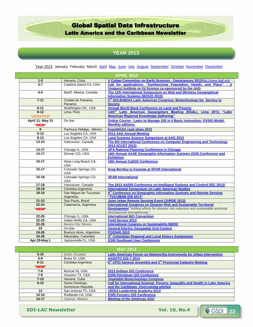
Year 2013 January February March April May June July August September October November December
APRIL 2013 1-5 Havana, Cuba V Cuban Convention on Earth Sciences - Geosciences 2013http://www.lagf.org/
3-7
Catalina Island CA, USA
Call for applications: "Synthesizing Population, Health, and Place" - A Vespucci Institute on GI Science co-sponsored by the AAG
4-5
Banff, Alberta, Canada
The 12th International Symposium on Web and Wireless Geographical Information Systems (W2GIS 2013)
7-11
Ciudad de Panama, Panama
3rd
SOLBABIAA Latin American Congress: Biotechnology for Service to Society
8-11 Washington DC, USA Annual World Bank Conference on Land and Poverty 8-12
*UPDATED*
Lima, Perú 14thth
L M ( L) L “L K ”
April 11- May 13
*NEW*
On line Online Course - Learn to Manage GIS in 4 Basic instruction: GVSIG Model. Monthly editions.
9 Pachuca Hidalgo, México ExpoSIGSA road show 2013
9-13 Los Angeles CA, USA 2013 AAG Annual Meeting
9-13 Los Angeles CA, USA Land Systems Science Symposium at AAG 2013
13-14
Vancouver, Canada The 5th International Conference on Computer Engineering and Technology 2013 (ICCET 2013)
13-17 Chicago IL, USA APA National Planning Conference in Chicago
14-17
Denver CO, USA 16th Annual AAAE Geographic Information Systems (GIS) Conference and Exhibition
15-17
West Long Beach CA, USA
19th Annual CalGIS Conference
15-17
Colorado Springs CO, USA
Greg Bentley to Keynote at SPAR International
15-18
Colorado Springs CO, USA
SPAR International
17-18 Vancouver, Canada The 2013 AASRI Conference on Intelligent Systems and Control (ISC 2013)
18-19 Córdoba-Argentina International Symposium on Latin American Studies
18-19 San Miguel de Tucumán, Argentina
4th
Conference on Geographic Information Systems and Remote Sensing “T M "
21-23 Sao Paulo, Brazil Joint Urban Remote Sensing Event (JURSE 2013)
22-24
*NEW*
Catamarca, Argentina
International Congress on Disaster Risk and Sustainable Territorial Development "Adding efforts for disaster risk reduction and sustainable territorial development strengthening "
22-25 Chicago IL, USA International BIO Convention
22-25 Indian Wells CA, USA Field Service 2013
22-25 Mexico City, Mexico International Congress on Sustainability IBERO
23 On line General Electric Geospatial Grid Contest
24-26 Buenos Aires, Argentina FOSS4G 2013
24-26 Manizales, Colombia 4th
Colombian Regional and Local History Symposium
Apr.29-May.1 Jacksonville FL, USA ESRI Southeast User Conference
MAY 2013 5-10 Quito, Ecuador Latin American Forum on Noteworthy Instruments for Urban Intervention
5-8 Boise ID, USA AASHTO GIS-T 2013
6-11
*NEW*
Córdoba Argentina 6th
CPCI General Assembly and 3rd
Provincial Cadastre Meeting
7-8 Muncie IN, USA 2013 Indiana GIS Conference
7-9 Houston TX, USA ESRI Petroleum GIS Conference
7-10 Havana, Cuba Vegetable Biotechnology Congress
8-10
Santo Domingo, Dominican Republic
Call for International Seminar: Poverty, Inequality and Health in Latin America and the Caribbean: Overcoming whirled
13 San Antonio TX, USA URISA Leadership Academy 2013 14-16 Redlands CA, USA ESRI Forestry GIS Conference
14-17 Cancun, Mexico Meeting of the Américas AGU
YEAR 2013

Global Spatial Data Infrastructure
Latin America and the Caribbean Newsletter
SDI-LAC Newsletter Vol. 10, No.4 23
14-17
Cancun, Mexico
Earthquakes and Tsunamis - Historical and Geological Records & Modeling at the AGU Meeting of the Americas
15-17
Webinar IV National Working days on Social History and Second Meeting of the International Network of Social History
17-27 San Francisco CA, USA International Conference on Software Engineering - ICSE 2013
19-22
*NEW*
Ocho Ríos, Jamaica IFIP 12th International Conference on Social Implications of Computers in Developing Countries
20
*NEW*
San Francisco CA, USA GTSE 2013 Workshop collocated with ICSE 2013
20-22 Washington DC, USA Location Intelligence &Oracle Spatial and Graph User Conference
20-23 Cincinnati OH, USA World Environmental & Water Resources Congress 2013
21-23
*NEW*
Washington DC, USA UCGIS 2013 Symposium
21-24
Denver CO, USA 2013 The National Map Users Conference and Community for Data Integration Workshop and Training
22-24
Ciudad de General Roca, Argentina
II Iberoamerican Meeting on Policy Management and Cultural Industries “Promoting Rights through Culture”
26
San Francisco CA, USA
GTSE 2013, SEMAT Workshop on a General Theory of Software Engineering (GTSE)
28-30 Buenos Aires, Argentina Argentinean Congress on Landscape Ecology CAEP 2013
May 28-Jun.1 Lawrence KS,USA Changing Nature: Migrations, Energies, Limits
May 30-Jun.1
*NEW*
Villa Mercedes, San Luis. Argentina
XXII Geography Teachers National Meeting "Reassessing spaces, histories and identities"
JUNE 2013 2-26
*NEW*
San José, Costa Rica 34th International Course on Protected Areas and Biological Corridors: Tools for Mitigation and Adaptation to Climate Change
3-5 State College PA, USA 2013 PA GIS Conference
3-6 Las Vegas, NV, USA Hexagon 2013
8-9 San Francisco CA, USA OpenStreetMap's Annual U.S. State of the Map Conference
Jun 10 – Jul 25
Atlanta GA, USA
Research Experiences for Undergraduates (REU) Site: Addressing Social and Environmental Disparities through Community Geography and Geographic Information Systems
12-14 México City, México SIGSA/ESRIUsers National Meeting 2013
12-15 San Jose, Costa Rica Third IUFRO Latin American Congress
13 Caracas, Venezuela Esri User Conference and National Envi 2013
17-20 Miami FL, USA ’ H 18-21 Sao Paulo, Brazil Mundo GEO#Connect Latin America 2013
19-20 São Paulo, Brazil Location Intelligence Brazil
18-21
Victoria BC, Canada CoastGIS 2013 Conference: Monitoring and Adapting to Change on the Coast The 11th International Symposium for GIS and Computer Cartography for Coastal Zone Management
19 Sao Paulo, Brazil Location Intelligence Brazil
25-27 Toronto, Canada Optech Third Imaging and Lidar Solutions Conference, ILSC 2013
JULY 2013 Jul.1 – Sep. 30
*NEW*
On line Learning Course: Integrated watershed management
Jul. 3 – Aug. 3
*NEW*
Fort Collins CO, USA
Protected Area Management Course
3-5
Tegucigalpa, Honduras
14th
Iberoamerican Conference on Geographic Information Systems (CONFIBSIG)
6-9 San Diego CA, USA ESRI Education GIS Conference
6-9 San Diego CA, USA ESRI Survey Summit
7-9 San Diego CA, USA ESRI Business and Location Analytics Summit
7-12 East Lansing MI, USA 15th International Medical Geography Symposium (IMGS 2013)
8-12 San Diego CA, USA ESRI International User Conference
8-13
*NEW*
Cartago, Turrialba, Costa Rica
IX International Course: Tools for Carbon Sequestration Monitoring Systems and Land Use
10
*NEW*
Montreal QC, Canada
CSWS 2013 Fourth Canadian Semantic Web Symposium

Global Spatial Data Infrastructure
Latin America and the Caribbean Newsletter
SDI-LAC Newsletter Vol. 10, No.4 24
15-25
*NEW*
Cartago, Turrialba, Costa Rica
International Course: Extension methodologies for sustainable rural development
22-24 San Jose CA, USA COM.Geo 2013
22-26 San Diego CA, USA CMSC 2013
22-26 Rockport Maine, USA 2013 MAPPS Summer Conference
23-26 Barquisimeto, Venezuela 5th International Congress on Historical Sciences in Venezuela (1st Call)
AUGUST 2013 1-4 Denver CO, USA NCGE 2013 National Conference on Geography Education
11-15 Newfoundland and Labrador, Canada
Canadian Association of Geographers 2013 Annual Meeting More: http://www.mun.ca/cag2013/
12-23
*NEW*
Cartago, Turrialba, Costa Rica
14th
International Course economic and institutional foundations for the Management and Assessment of Environmental Services
21-24 Colorado Springs, CO USA
GeoGathering 2013
25-29 Arlington VA, USA Advances in Geospatial Technologies for Health 26-27 Raleigh NC, USA 2
nd International Conference on Hydrology & Ground Water Expo
26-30
*NEW*
Turrialba, Costa Rica V Adaptation to Climate Change International Course: The Role of Ecosystem Services
29-31 Ibagué, Colombia 20th Colombian Congress of Geography
SEPTEMBER 2013 Sep. 2 – Nov.25
*NEW*
Turrialba, Costa Rica
E-Learning: Land use planning at the municipal level
7-10
Cambridge MA,USA
International Map Industry Association (IMIA) Americas Annual Meeting and Member Showcase
8-11 Daytona Beach FL, USA Lucity Annual Conference and Training (ACT) 2013
9-13
*NEW*
Turrialba, Costa Rica International Course of Forest Inventory Data Analysis
11-13 Rio de Janeiro, Brazil Latin America Geospatial Forum 2013
16-17
*NEW*
Buenos Aires, Argentina 2nd
UNI-COM Latin American Congress: Quality of Life in Latin America and the Caribbean
16-19 Providence RI, USA GIS-Pro 2013: URISA's 51st Annual Conference for GIS Professionals
16-27
*NEW*
Turrialba, Costa Rica
International Course: Using the SWAT Model as a tool for Watershed Management
17-20
*NEW*
La Plata, Argentina 7th
Argentine Congress on Hydrogeology and 6th
Hispano-Latin American Seminar on current topics in Groundwater Hydrology
23-25 Edmonton Alberta, Canada
Ga3 - Geospatial - anywhere, anytime for anyone
24-26 Atlanta GA, USA Conferencia Servicio de Campo del Este 2013
25-28
*NEW*
Lake Tahoe CA, USA
AAG Pacific Coast Division Fall Regional Meeting
25-27
*NEW*
Manizales, Colombia 2nd Colombian Bioinformatics Computational Biology Congress (CCBCOL)
Sep.30-Oct.4 Turrialba, Costa Rica Climate-smart Territories at the tropic.
Information: [email protected]
OCTOBER 2013 3-4
Polvorines, Argentina II National Congress on Geographic Information Technologies and II Days on
Geographic Information Systems Deadline for abstracts (300 words): April 30, 2013. E mail: [email protected] / [email protected]
4-5
Entre Ríos-Concordia, Argentina
26th
Foresting Working Days from Entre Rios
7-31
*NEW*
Turrialba, Costa Rica
25th
Intensive Course International Diversified Management of Natural Tropical Forests: Managing the Challenges of Climate Change
9-11 Buenos Aires, Argentina 4th Congress on Environmental Sciences
10-12 Omaha NE, USA AAG Great Plains/Rocky Mountains Division Regional Meeting
10-13
Oakland CA, USA North American Association for Environmental Education: 41st annual
conference
14-17 Belize Ciity, Belize ICRI 28th M ( M )

Global Spatial Data Infrastructure
Latin America and the Caribbean Newsletter
SDI-LAC Newsletter Vol. 10, No.4 25
16-18 Washington DC, USA GIS in Transit Conference
17-19 Eau Claire WI, EUA USA AAG West Lakes Division Regional Meeting
18-19 Worcester MA, USA New England/St. Lawrence Valley (NESTVAL) Division Regional Meeting
21-25
*NEW*
Ibagué, Tolima
10th
International Course Tools for Carbon Sequestration Monitoring Systems and Land Use
23-25
*NEW*
Santiago de Chile, Chile LARS Latin American Remote Sensing Week - 2013
23-26
*NEW*
Mendoza, Argentina
4th
National Congress on Geography of Public Universities and 10th
Cuyanas Workings day The complexity, permanent attribute of geography science
24-26 Nacogdoches TX, USA AAG Southwest Division (SWAAG) Annual Meeting
25-26 Toledo OH,USA AAG East Lakes Division Regional Meeting (jointly with CAG, Ontario)
27-31 Kansas City MO, USA National States Geographic Information Council (NSGIC) Annual Meeting 2013
Oct. 27 – Nov.1
*NEW*
Burlingame CA, USA ACM International Conference on Information and Knowledge Management (CIKM 2013)
Oct.30-Nov.2
Annapolis MD, USA
AAG Middle Atlantic Division Regional Meeting (jointly with AAG Applied Geography Specialty Group)
Oct.31-Nov.2 Tampa FL, USA Fifty-fourth Annual Meeting Society for the History of Discoveries
Oct.31-Nov.3
*NEW*
Trevelin – Chubut, Argentina
International Congress of Geography / Geography Week 74
NOVEMBER 2013 4-8 Addis Abbaba, Ethiopia. AfricaGIS 2013 Conference and the GSDI 14 World Conference
4-8
*NEW*
Turrialba, Costa Rica Biodiversity Analysis: from Functional Diversity to Ecosystem Services
6-9
Havana, Cuba 3rd International Congress on Local Development “ or Local Sustainable Development”
13-16
Atlanta GA, USA
60th Annual North American Meetings of the Regional Science Association International
21-24 Chicago IL, USA 38th
Annual Meeting of the Social Science History Association (SSHA)
24-26 Roanoke VA, USA Southeast (SEDAAG) Division Regional Meeting
Nov. 25 – Dec.6
*NEW*
Turrialba, Costa Rica International Course: Comprehensive Management of Irrigation: Resilience to natural hazards geological and climatic
DECEMBER 2013 2-6 Lima, Peru 15th UN Industrial Development Organization (UNIDO) Conference 2013
(Back to top)
(Back to top)
To subscribe to SDI-LAC, please do so online at: http://www.gsdi.org/newslist/gsdisubscribe.asp Nancy Aguirre, PAIGH, Editor [email protected] Global Spatial Data Infrastructure Association, http://www.gsdi.org
DISCLAIMER: GSDI, PAIGH and the Editor will not be held liable for any errors, mistakes, misprints or incorrect information from third parties. Copyright © 2013. All rights reserved.


![Spatial Data Infrastructure (SDI) “[Spatial Data Infrastructure] provides a basis for spatial data discovery, evaluation, and application for users and.](https://static.fdocuments.in/doc/165x107/56649d5f5503460f94a3f713/spatial-data-infrastructure-sdi-spatial-data-infrastructure-provides.jpg)