Global Positioning System(Report)
15
Global Positioning System by Mary E. Reece Submitted to Lawrence J. Clark, Professor of Technical Writing New Mexico Institute of Mining and Technology April 2000 Abstract This report explains what the Global Positioning System (GPS) is and how it is changing the world. The many applications of this system will be explained while concentrating on its impact on mining. New applications are currently being discovered and implemented while future applications may be limitless.
-
Upload
9533956818 -
Category
Documents
-
view
218 -
download
0
Transcript of Global Positioning System(Report)

8/2/2019 Global Positioning System(Report)
http://slidepdf.com/reader/full/global-positioning-systemreport 1/15
Global Positioning System
by Mary E. Reece
Submitted to Lawrence J. Clark, Professor of Technical WritingNew Mexico Institute of Mining and Technology
April 2000
Abstract
This report explains what the Global Positioning System (GPS) is and how it ischanging the world. The many applications of this system will be explained whileconcentrating on its impact on mining. New applications are currently being
discovered and implemented while future applications may be limitless.

8/2/2019 Global Positioning System(Report)
http://slidepdf.com/reader/full/global-positioning-systemreport 2/15
Table of Contents
Cover Page
Executive Summary
Introduction
Basic ConceptsWhat is GPS? Segments
History History of Navigation - includes descriptions and shortcomingss
of other navigational systemsHistory of GPS
How does it work?
Mathematical Basis Services (PPS vs. SPS) Augmentations
Applications Application categories Open-pit Mining
Conclusion
GPS Update (May 2000)
Glossary
Works Cited

8/2/2019 Global Positioning System(Report)
http://slidepdf.com/reader/full/global-positioning-systemreport 3/15
Executive Summary
There are many current uses for the Global Positioning System (GPS) andmany more that have not yet been thought of or implemented . This report willdemonstrate how much GPS has improved navigation and explain some of itslesser known applications. A comparison to other navigational systems and asection on how GPS works are included. The research for this report wasconcentrated in the field of open-pit mining and so this application of GPS will beexplained in greater detail than the other areas of applicability. Also explained ishow society is being affected by these applications and what future applicationsmay be in store.
Introduction
This report is about the Global Positioning System (GPS) and its manyapplications. The history of navigation and how GPS works are important forunderstanding this report and so each has its own section within the report. How itcompares to other navigational systems and its uses outside of navigation will bediscussed as well. The goal of this report is to explain how GPS technology isaffecting society. This report is intended for anyone who:- uses GPS in their job,
- uses GPS for leisure activities,- is curious about the applications, or- is curious about how it works,Actually, this report is for everyone since GPS affects us all whether we directlyuse it or not.
Ultimately, this report conveys that GPS is not just a navigational system. Agood analogy is the clock which was originally used as a navigational tool. Sincestars look different at different times, people who used celestial navigation neededto know what time of night it was. The market forecasters shortly after the
invention of the clock probably could not have imagined the impact thattimekeeping would have on the world or the other products and services that thistechnology would someday make possible. The same situation can be found nowwith GPS. In fact, it was first intended for military use but is now meetingnumerous civilian needs as well. We can only guess at some of the eventual usesthat this relatively new technology will bring about.
8/2/2019 Global Positioning System(Report)
http://slidepdf.com/reader/full/global-positioning-systemreport 4/15
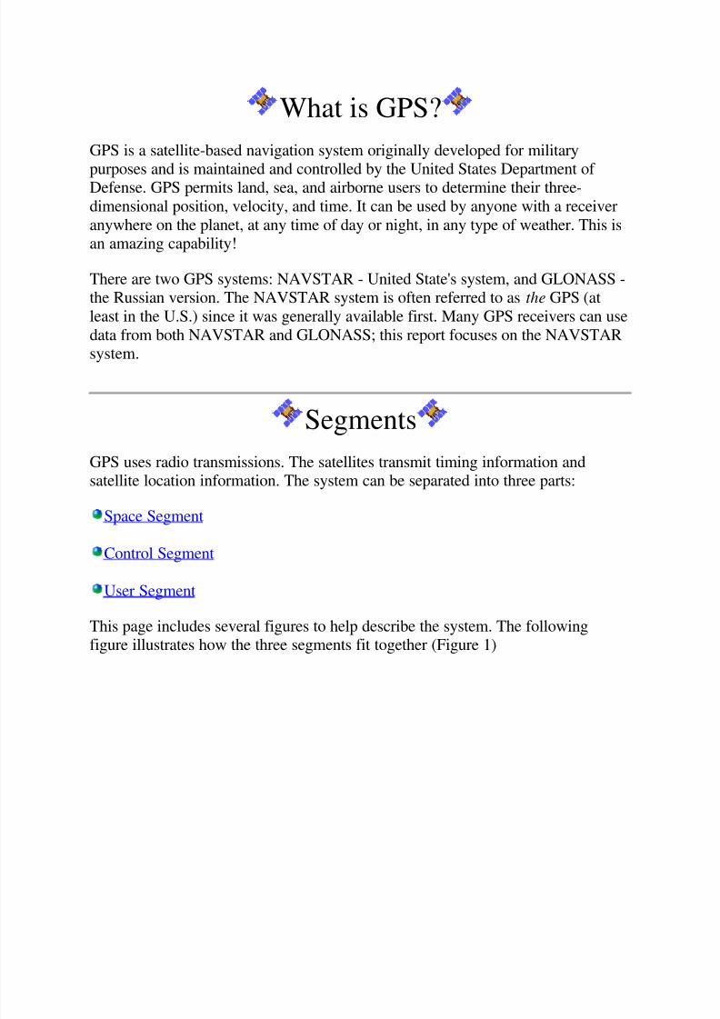
What is GPS?
GPS is a satellite-based navigation system originally developed for militarypurposes and is maintained and controlled by the United States Department of Defense. GPS permits land, sea, and airborne users to determine their three-dimensional position, velocity, and time. It can be used by anyone with a receiveranywhere on the planet, at any time of day or night, in any type of weather. This isan amazing capability!
There are two GPS systems: NAVSTAR - United State's system, and GLONASS -the Russian version. The NAVSTAR system is often referred to as the GPS (atleast in the U.S.) since it was generally available first. Many GPS receivers can usedata from both NAVSTAR and GLONASS; this report focuses on the NAVSTAR
system.
Segments
GPS uses radio transmissions. The satellites transmit timing information andsatellite location information. The system can be separated into three parts:
Space Segment
Control Segment
User Segment
This page includes several figures to help describe the system. The followingfigure illustrates how the three segments fit together (Figure 1)

8/2/2019 Global Positioning System(Report)
http://slidepdf.com/reader/full/global-positioning-systemreport 5/15
Figure 1 - GPS Segments
Space Segment
The space segment consists of the satellites themselves. According to the UnitedStates Naval Observatory, there are currently 27 operational GPS satellites about11,000 miles up in space. This constellation (see Figure 2 below) provides betweenfive and eight GPS satellites visible from any point on the earth. The nextscheduled launch is May 10, 2000.

8/2/2019 Global Positioning System(Report)
http://slidepdf.com/reader/full/global-positioning-systemreport 6/15
Figure 2 - The Space Segment
It takes each satellite about twelve hours to orbit the earth. There are six orbitalplanes with at least four satellites in each plane.
Control Segment
The control segment is a group of ground stations that monitor and operate theGPS satellites. There are monitoring stations spaced around the globe and oneMaster Control Station located in Colorado Springs, Colorado (see Figure 3
below). Each station sends information to the Control Station which then updatesand corrects the navigational message of the satellites. There are actually fivemajor monitoring systems, the figure below does not include the Hawaiian station.
Figure 3 - The Control Segment
User Segment
The user requires a GPS receiver in order to receive the transmissions from thesatellites. The GPS receiver calculates the location based on signals from thesatellites. The user does not transmit anything to the satellites and therefore thesatellites don't know the user is there. The only data the satellites receive is fromthe Master Control Station in Colorado. The users consist of both the military and
civilians.

8/2/2019 Global Positioning System(Report)
http://slidepdf.com/reader/full/global-positioning-systemreport 7/15
History of Navigation
GPS is primarily a navigational system, so a background on navigation will giveinsight as to how extraordinary the Global Positioning System is.
People first navigated only by means of landmarks - mountains, trees, or leavingtrails of stones. This would only work within a local area and the environment wassubject to change due to environmental factors such as natural disasters.
For traveling across the ocean a process called dead reckoning, which used amagnetic compass and required the calculation of how fast the ship was going, wasapplied. The measurement tools were crude and inaccurate. It was also a verycomplicated process.
When traveling over the ocean, people began using the stars as guidelines. Thestars appear different from different locations on Earth so analyzing the stars gavesailers the basic direction to follow. Celestial navigation was our primary means of navigation for hundreds of years. It was a time-consuming and complicated task of measuring the angles between stars - a process of triangulation. The degree of precision was limited. The sextant was developed during this time but since it onlymeasured latitude, a timepiece was also invented so that the longitude could alsobe calculated. This type of navigation only worked at night and in clear weatherwhich was a great disadvantage.
It was not until the 20th century that ground-based radio navigation systems wereintroduced. Some are still in use today. GPS is a satellite radio navigation system,but the first systems were ground-based. They work in the same way as does GPS:users (receivers) calculate how far away they are from a transmitting tower whoselocation is known. When several towers are used, the location can be pinpointed.This method of navigation was a great improvement, yet it had its own difficulties.An example of such a system is LORAN. Each tower had a range of about 500miles and had accuracy good to about 250 meters. LORAN was not a globalsystem and could not be used over the ocean. Because ground based systems sendsignals over the surface of the earth, only two-dimenstional location can bedetermined. The altitude cannot be calculated so this system could not be appliedto aviation. The accuracy of such systems could be affected by geography as well.The frequency of the signal affected accuracy; a higher frequency would allow forgreater accuracy, but the user would need to remain within the line of sight. Thefirst global navigation system was called OMEGA. It was a ground-based systembut has been terminated as of 1997.
Satellite navigation systems can provide high frequency signals allowing for high
accuracy, as well as global access because the satellites are so high up thatremaining within the line of sight of the satellites is easy.

8/2/2019 Global Positioning System(Report)
http://slidepdf.com/reader/full/global-positioning-systemreport 8/15
History of GPS
Prior to the development of the GPS system, the first satellite system was calledTransit and was operational begining in 1964. Transit had no timing devicesaboard the satellites and the time it took a receiver to calculate its position wasabout 15 minutes. Yet, much was learned from this system. GPS is a greatimprovement over the Transit system. The original use of GPS was as a militarypositioning, navigation, and weapons aiming system to replace not only Transit,but other navigation sytems as well. It has higher accuracy and stable atomicclocks on board to achieve precise time transfer. The first GPS satellite was
launched in 1978 and the first products for civilian consumers appeared in the mid1980's. It was in 1984 that President Reagan announced that a portion of thecapabilities of GPS would be made availabe to the civil community. The system isstill being improved and new, better satellites are still being launched to replaceolder ones.
How does GPS work?
Mathematical Basis
Each of the GPS satellites transmits radio signals. GPS receivers pick up thesesignals and measure the distance to a satellite by multiplying the speed of thesignal by the time it takes the signal to get there. The speed of the signal is thespeed of light and the time is encoded within the signal. The satellites also sendinformation on their exact location.
In order to find longitude, latitude, and altitude, four satellites are needed. If a
measurment is taken using just one satellite, then all that is known is that thereceiver is on the surface of a sphere with radius equal to the distance to thesatellite. If two satellites are used, then the receiver must be on the surface of bothspheres which is the intersection of the two spheres or the perimeter of a circle. If athird satellite is used, then the location of the user is narrowed down to the twopoints where the three spheres intersect. Three measurements are enough for landreceivers since the lower of the two points would be selected. But when in the airor space, four satellites are needed: the intersection of all four spheres will be thereceiver's location. When more than four satellites are used, greater accuracy canbe achieved.
8/2/2019 Global Positioning System(Report)
http://slidepdf.com/reader/full/global-positioning-systemreport 9/15
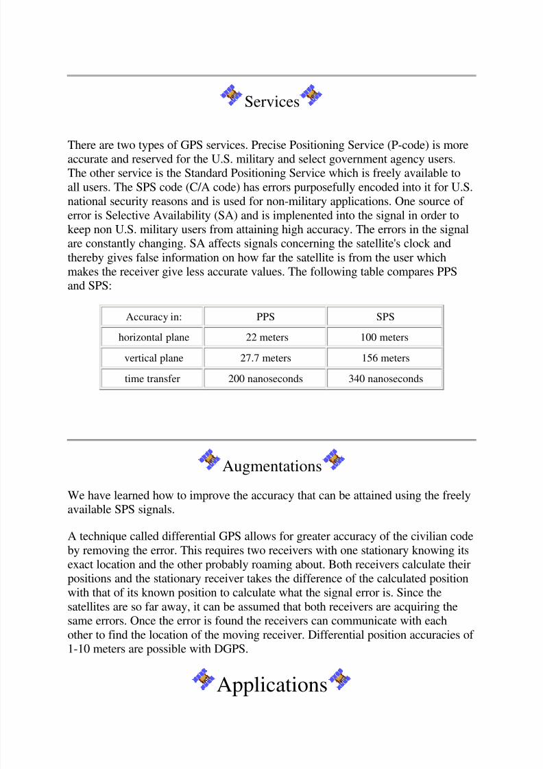
Services
There are two types of GPS services. Precise Positioning Service (P-code) is moreaccurate and reserved for the U.S. military and select government agency users.The other service is the Standard Positioning Service which is freely available toall users. The SPS code (C/A code) has errors purposefully encoded into it for U.S.national security reasons and is used for non-military applications. One source of error is Selective Availability (SA) and is implenented into the signal in order tokeep non U.S. military users from attaining high accuracy. The errors in the signalare constantly changing. SA affects signals concerning the satellite's clock andthereby gives false information on how far the satellite is from the user which
makes the receiver give less accurate values. The following table compares PPSand SPS:
Accuracy in: PPS SPS
horizontal plane 22 meters 100 meters
vertical plane 27.7 meters 156 meters
time transfer 200 nanoseconds 340 nanoseconds
Augmentations
We have learned how to improve the accuracy that can be attained using the freelyavailable SPS signals.
A technique called differential GPS allows for greater accuracy of the civilian codeby removing the error. This requires two receivers with one stationary knowing itsexact location and the other probably roaming about. Both receivers calculate theirpositions and the stationary receiver takes the difference of the calculated positionwith that of its known position to calculate what the signal error is. Since thesatellites are so far away, it can be assumed that both receivers are acquiring thesame errors. Once the error is found the receivers can communicate with eachother to find the location of the moving receiver. Differential position accuracies of 1-10 meters are possible with DGPS.
Applications

8/2/2019 Global Positioning System(Report)
http://slidepdf.com/reader/full/global-positioning-systemreport 10/15
The applications of the Global Positioning System fall into five categories:location, navigation, timing, mapping, and tracking. Each category contains uses
for the military, industry, transportation, recreation and science.
Location
This category is for position determination and is the most obvious use of theGlobal Positioning System. GPS is the first system that can give accurate andprecise measurements anytime, anywhere and under any weather conditions. Someexamples of applications within this category are:
1. Measuring the movement of volcanoes and glaciers.
2. Measuring the growth of mountains.3. Measuring the location of icebergs - this is very valuable to ship
captains helping them to avoid possible disasters.4. Storing the location of where you were - most GPS receivers on the
market will allow you to record a certain location. This allows you tofind it again with minimal effort and would prove useful in a hard tonavigate place such as a dense forest.
Navigation
Navigation is the process of getting from one location to another. This was thewhat the Global Positioning System was designed for. The GPS system allows usto navigate on water, air, or land. It allows planes to land in the middle of mountains and helps medical evacuation helicopters save precious time by takingthe best route.
Timing
GPS brings precise timing to the us all. Each satellite is equipped with anextremely precise atomic clock. This is why we can all synchronize our watches sowell and make sure international events are actually happening at the same time.
Mapping
This is used for creating maps by recording a series of locations. The best exampleis surveying where the DGPS technique is applied but with a twist. Instead of
making error corrections in real time, both the stationary and moving receiverscalculate their positions using the satellite signals. When the roving receiver is

8/2/2019 Global Positioning System(Report)
http://slidepdf.com/reader/full/global-positioning-systemreport 11/15
through making measurements, it then takes them back to the ground station whichhas already calculated the errors for each moment in time. At this time, theaccurate measurements are obtained.
Tracking
The applications in this category are ways of monitoring people and things such aspackages. This has been used along with wireless communications to keep track of some criminals. The suspect agrees to keep a GPS receiver and transmitting devicewith him at all times. If he goes where he's not allowed to, the authorities will benotified. This can also be used to track animals.
Many applications use a combination of the above categories. The following is alist of some additional areas where the global positioning service is being applied:
1. precision farming2. open-pit mining 3. oil exploration4. airport and harbor approaches5. animal migration and population studies6. vehicle tracking7. construction - tunnels, golf courses, roads, etc.
8. emergency services - the closest ambulance or fire truck is sent to anemergency, thereby saving time.
9. atmospheric studies - ozone layer, air quality, etc.10. archaeological explorations11. recreational activities - camping, boating, etc.12. astronomical telescope pointing13. networking - speed is increased, the Internet is highly synchronized
because of GPS.14. aiding the blind
Open-pit Mining
This is an area where very high precision is needed, regular DGPS techniques arenot accurate enough. DGPS improves the accuracy from hundreds of meters downto less than 10 meters, but a technique called Real Time Kinematic (GPS) canincrease the accuracy to within several centimeters. This RTK technique involvesnot only receiving signals from satellites but also receives correction information
from nearby reference points.

8/2/2019 Global Positioning System(Report)
http://slidepdf.com/reader/full/global-positioning-systemreport 12/15
RTK GPS is used in many other areas other than mining, but why does open-pitmining require such high accuracy? It can be used for measuring how steep a roadshould be, saving construction time. It can also be used for high accuracy withdrills and shovels. The main reason the high accuracy is needed is used for ore
control to make sure the different levels of ore containing dirt go to the rightplaces. Not all mines have the equipment to use RTK GPS yet, but it may becomenecessary as the minerals become less abundant and better techniques must beapplied.
Conclusion
The technology of the Global Positioning System is allowing for huge changes insociety. The applications using GPS are constantly growing. The cost of the
receivers is dropping while at the same time the accuracy of the system isimproving. This affects everyone with things such as faster Internet speed and saferplane landings.
Even though the system was originally developed for military purposes, civil salesnow exceed military sales (See Figure 1 below).
GPS Update
On May 1, 2000 President Clinton announced that the government will no longer
scramble signals from the GPS satellites. This means that civilians will be able toenjoy the high accuracy that the military has had for years. The DGPS techniquesand the equipment needed to use them will no longer be necessary to get the sameeffects on accuracy. The affects on society will be:
more reliable and accurate measurementsless costly to corporations - since the error removing equipment will no longer
be neededmore affordable and accessible to consumersgreater incentive for the development of new uses

8/2/2019 Global Positioning System(Report)
http://slidepdf.com/reader/full/global-positioning-systemreport 13/15
The accuracy should increase ten-fold, from 100 meter to 10 meter accuracy. The$8 billion dollar a year GPS industry should also see a much larger than expectedincrease in sales.
Glossary and Acronyms
C/A code -The standard (Course/Acquisition) GPS code. A sequence of 1023pseudo-random, binary, biphase modulations on the GPS carrier at a chip rate of 1.023 MHz. Also known as the "civilian code."
Control segment - A world-wide network of GPS monitor and control stationsthat ensure the accuracy of satellite positions and their clocks.
Differential positioning - Accurate measurement of the relative positions of tworeceivers tracking the same GPS signals.
DGPS - Differential GPS
Ephemeris - The predictions of current satellite position that are transmitted to theuser in the data message. A table given for successive days the positions of heavenly bodies.
GLONASS - GLObal NAvigation Satellite System - Russian
GPS - Global Positioning System
Latitude - the location on the Earth measuring how far north or south of theequator one is.
Longitude - the location on the Earth measured east or west
LORAN - LOng RAnge Navigation
Nautical mile - length measurement used in navigation and is 1/60 of 1 degree of the equator. One nautical mile is 6,080.2 feet whereas one mile is 5,280 feet.
NAVSTAR GPS - the Navigation Satellite Timing and Ranging GPS
P-code - The Precise code. A very long sequence of pseudo random binary biphasemodulations on the GPS carrier at a chip rate of 10.23 MHz which repeats aboutevery 267 days. Each one week segment of this code is unique to one GPS satelliteand is reset each week.
Precise Positioning Service (PPS) - The most accurate dynamic positioningpossible with standard GPS, based on the dual frequency P-code and no SA.

8/2/2019 Global Positioning System(Report)
http://slidepdf.com/reader/full/global-positioning-systemreport 14/15
Pseudolite - A ground-based differential GPS receiver which transmits a signallike that of an actual GPS satellite, and can be used for ranging.
RTK - Real Time Kinematic
Satellite constellation - The arrangement in space of a set of satellites.
Selective Availability (SA) - A policy adopted by the Department of Defense tointroduce some intentional clock noise into the GPS satellite signals therebydegrading their accuracy for civilian users.
Space segment - The part of the whole GPS system that is in space, i.e. thesatellites.
Standard Positioning Service (SPS) - The normal civilian positioning accuracyobtained by using the single frequency C/A code.
User segment - The part of the whole GPS system that includes the receivers of GPS signals.
Works Cited
Kaplan, E. (1996). Understanding GPS - Principles and Applications. Boston:Artech House.
U.S. Naval Observatory (2000). Current GPS Constellation.http://tycho.usno.navy.mil/gpscurr.html
Trimble Navigation Limited (1998). Putting GPS to Work.http://www.trimble.com/gps/puttinggps/gpsfram1.htm
The Aerospace Corporation (1999). GPS Elements.
http://www.aero.org/publications/GPSPRIMER/GPSElements.html
Dommety, G. and Jain, R. (1996). Potential Networking Applications of GPS Technical report TR-24. http://www.cis.ohio-state.edu/~jain/papers/gps.htm
Dana, P. (1999) Global Positioning System Overview.http://www.colorado.Edu/geography/gcraft/notes/gps/gps_f.html
Critical Technologies Institute (1995). A Policy Direction for the GlobalPositioning
System: Balancing National Security and Commercial Interests.

8/2/2019 Global Positioning System(Report)
http://slidepdf.com/reader/full/global-positioning-systemreport 15/15
http://www.rand.org/publications/RB/RB1501/RB1501.html
Holland, S. (2000, May 1). GPS Becomes 10X More Accurate. Reuters Limited.http://live.altavista.com/scripts/editorial.dll?efi=980&ern=y&ei=1751558