Global Geospatial Information Management in Tunisia...
22
Global Geospatial Information Management in Tunisia Situation and Future prospects Republic of Tunisia Ministry of National Defense National Mapping and Remote Sensing Center (NMRC) Qatar, February 2013
Transcript of Global Geospatial Information Management in Tunisia...

Global Geospatial Information Management in Tunisia
Situation and Future prospects
Republic of TunisiaMinistry of National Defense
National Mapping and Remote Sensing Center (NMRC)
Qatar, February 2013

Presentation outline
I. History
II. Organization of the geomatics’ sector in Tunisia
III. National schema of geomatic
Organisation of geomatic sector
Tunisian Marine charts
Geographical names Activity
IV. International activities
V. Material means
2

July 1886: Creation of the Survey Department
I. History
July 1988: Creation of the National Remote Sensing Centre (Law 83‐88)
September 1974: Creation of the Office of Topography and Cartography (Law 100‐74)
September 1966: Development of the first topographic map, scale 1/50 000 (Jerba), presented at the 2nd Regional
Conference for Africa Cartography held in Tunis
1980: Creation of CHOMN (Navy Centre for Hydrographic and Oceanographic )
1980: Creation of DSGHA (Defense’s Department of Geographical and Hydrographical Mapping )
3 National Center of Mapping and Remote Sensing 33 National Mapping and Remote Sensing Center
Survey Department OTC DSGHA NRSC merging DSGHA/NRSC
1886 1974 1980 1988 2004
May 2004: Fusion CNT/ DSGHA

Users
2004 situation of the geomatics’ sector in Tunisia
The Office of Topography and Cartography is directly responsible for carrying out production activities of basic geographical data (geodesy, topographic maps topographic, cadastral, ...)
In 2004 and following its merging with the Military Geographic and Hydrographic Services, the mission of NRC was expanded and reached new areas such as topography , cartography, gravimetry, etc..
Private Study OfficesPrivate sectors contribute significantly to the production and delivery of geospatial products and services including aerial photography, surveying, photogrammetry, establishing city plans, the implementation of Spatial Data Bases, the Geographic Information Systems and various other value‐added products derived from satellite imagery. 4
I. History

Main actors of public and private sectors in charge of Geospatial Information production
Noted : Lack of coordination between the different stakeholders Absence of a centralized database Absence of a common reference Non‐enforcement of existing standards 5
I. History

6
Like the network transportation and the communication, the
Geographic information becomes an indispensable element for
economic development. The Tunisian government has decided to
organize this sector in order to avoid the problems mentioned
above by :
‐separating missions between NCR and OTC
‐support national stakeholders with geospatial information.
II . Organization of the geomatics’ sector in Tunisia

New organisation of geomatics’ sector
227
the Office of Topography and Cartography became mainly responsible of cadastre and topography
By law 20/2009 the cartography production was assigned to NCR which became NCMR. Its new missions are then: Production of the basic maps, of marine charts, space maps, thematic maps and cities plans,surveying, leveling, gravity, etc..
Private Study Offices:Private sectors continue playing mainly the same role as before with a better developpment of P2P activities:‐production and delivery of geospatial products and services,‐ surveying,, establishing city plans, ‐implementation of Spatial Data Bases,G hi I f ti S t d i th l dd d d t
II . Organization of the geomatics’ sector in Tunisia
II . Organization of the geomatics sector in Tunisia

National schema of geomatic: Strategic Issues
Establish the foundation for common information base to meet theneeds of the masses;
Ensure transparency, coherence, coordination and cooperation between geographic information producers and users.
Generate a high level of employability of geomatics, surveying, computer scientists, technicians, managers, librarians / archivists.
III . NATIONAL SCHEMA OF GEOMATIC

NATIONAL INFOSTRUCTURE: OBJECTIVES
Allow users and producers of geographic information sector have a common digital geographic basis, reliable, centralized, available and non‐redundant;
Enable policy makers to have a global view of the territory;
Provide to the different national authorities technical tools enabling a better management and control of development projects.
Develop public‐private partnership.
III . NATIONAL INFRASTRUCTURE
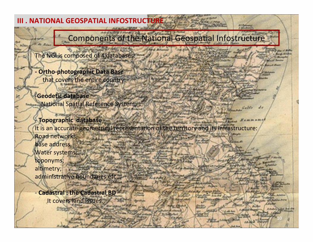
The NGI is composed of 4 databases:
‐ Ortho‐photographic Data Basethat covers the entire country.
‐Geodetic databaseNational Spatial Reference System.
‐ Topographic databaseIt is an accurate geometrical representation of the territory and its infrastructure:Road networks,base addressWater systems;toponyms;altimetry;administrative boundaries etc…
‐ Cadastral : the Cadastral BDIt covers land issues.
Components of the National Geospatial Infostructure
III . NATIONAL GEOSPATIAL INFOSTRUCTURE
10

NMRC is responsible to support national stakeholders with geospatial information , it
initiated a contract‐goal for the period 2012‐2021, whose objectives are:
1.A national topographic database at scale 1/2000 (NTDB2K) covering the tunisian big
cities,
2.A National Topographic Database 1:25,000 scale (NTDB25K) covering the northern and
central parts of Tunisia,
3.A national topographic database at scale 1:100,000 (NTDB100K) covering the southern
part of the country.
11 National Center of Mapping and Remote Sensing
Topographic Database
III . NATIONAL GEOSPATIAL INFRASTRUCTURE
Components of the National Geospatial Infrastructure

TNDB 2KTNDB 25K TNDB 100K
12 National Center of Mapping and Remote Sensing
Topographic Database
III . NATIONAL GEOSPATIAL INFRASTRUCTURE
Components of the National Geospatial Infrastructure
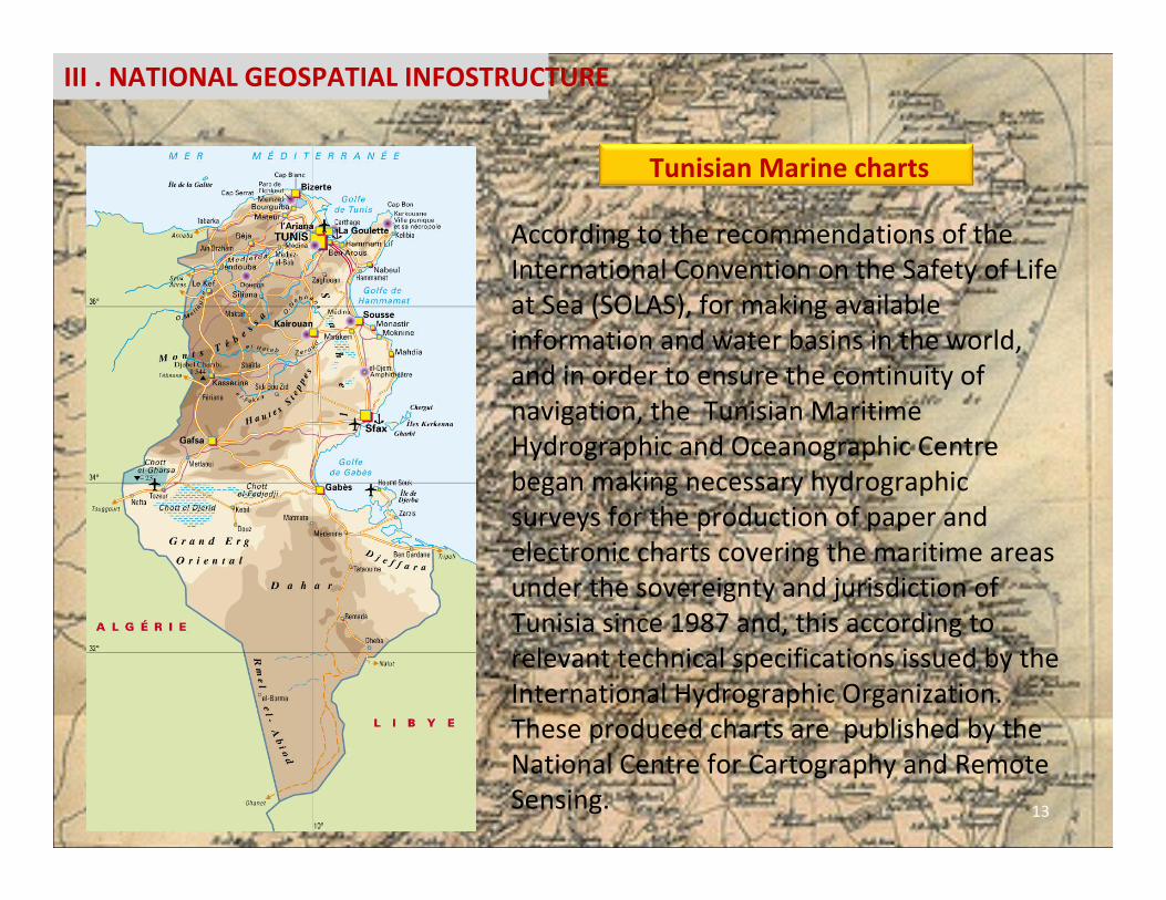
According to the recommendations of the International Convention on the Safety of Life at Sea (SOLAS), for making available information and water basins in the world, and in order to ensure the continuity of navigation, the Tunisian Maritime Hydrographic and Oceanographic Centre began making necessary hydrographic surveys for the production of paper and electronic charts covering the maritime areas under the sovereignty and jurisdiction of Tunisia since 1987 and, this according to relevant technical specifications issued by the International Hydrographic Organization. These produced charts are published by the National Centre for Cartography and Remote Sensing.
Tunisian Marine charts
13
III . NATIONAL GEOSPATIAL INFOSTRUCTURE

The National plan includes a series Ordnance Survey maps (paper and ENC) at different scales in accordance with international standards and recommendations:
Maps of ports:Large scale Maps (between 1: 5000 and 1: 15 000) are required for access to ports, port waters and areas with navigation in confined waters.Approach Maps:Medium scale maps (1: 25,000) are used for landings and for coastal navigation, as well as approaches to ports and tricky.Cabotage MapsThese are maps for coastal navigation (scale 1: 75,000), they are substantially parallel roads to the coast to ten or twenty nautical hazards.Landing Maps:They allow a ship to identify the coast as soon as possible (scale ranges1: 250 000), or the view is on the radar, and navigate along roads substantially parallel to the coast, at distances between 20 and 50 miles dangers. These maps, five in number, are part of a series of international maps.
Tunisian Marine charts
14
III . NATIONAL GEOSPATIAL INFOSTRUCTURE

Tunisian Marine charts published by NMRC
15
III . NATIONAL GEOSPATIAL INFOSTRUCTURE

• Geographical names constitue an integral part of the geospatial information.
• Tunisia has participated to UNGEGN meetings since 1982, through the Office of Topography and Cartography, main national mapping agency at that time.
• A restricted Geographical Name Committee was created in 1983 within OTC and held many meetings and workshops between experts from OTC and the concerned organizations, like the Geographic and Hydrographic Services of the Ministry of Defense (DSGHA, an institution merged to CNCT in 2004) and the Center of Economic and Social Studies and Researches (CERES), to study Beyrut 1972 transcription system before its implementation in the updating of its topographic maps .
• During the last 2 years and boosted by the UNGEGN recommandations and resolutions, the NMRC has presented a project for the creation of a National Toponymic Commission, Which project is pending approval.
16
III . NATIONAL GEOSPATIAL INFOSTRUCTURE
Geographical names activities

• NMRC is regularly and actively participating to all meetings and workshops related to the field either organized by ADEGN (Arabic Division of Experts on Geographical Names) , one of the 23 UNGEGN linguistic Divisions, or by UNGEGN. Without forgetting its participation to special meetings and workshops organized by UNECA/AUC to promote Toponymy in the African continent.
• At the national level NMRC participated In April 2007 with the Regional Centre of Remote Sensing for North African States (CRTEAN) and the African Organisation of Cartography and Remote Sensing (OACT ) to the organization of the 2nd Arabic seminar on the standardization of geographical names where a training course in toponymy was given by UNGEGN experts.
• Mme Naima Friha from the NMRC is the Vice Chairperson of the UNGEGN and also the Vice Chairperson of ADEGN
17
Geographical names activities

IV ‐ International activities
1818 National Mapping and Remote Sensing Center
• President of the Administrative Council of the OACT• Member of the International Astronautical Federation IAF• Member of The Committee on the peaceful of outer space
COPUOS.• Vice Chairperson of the United Nations Group of Experts
on Geographical Names (UNGEGN).
• President of the Administrative Council of the Regional Center for Remote Sensing of North African CountriesCRTEAN.
• The center also cooperates with similar centers in remote sensing: CRTS(Maroc), CNTS(Algérie), NARSS(Egypte), RJGC (Jordanie), GORS(Syrie)

1919 National Mapping and Remote Sensing Center
RADARSAT...RADARSAT...
INFOCARTO,CNES,IRD...INFOCARTO,CNES,IRD...
the center cooperate too with similar centers in
cartography and geospatial Information like:
‐ IGeoE: the army geographic institute of Portugal.
‐ IGMI : Military Geographical Institute of Italy.
‐ BGHOM : The geography, hydrography, oceanography
and meteorology office of French.
‐Geoinformation Office of the German Federal Armed
Forces (BGIO)
‐NGA: National Geospatial‐Intelligence Agency.
IV ‐ International activities

20 National Center of Mapping and Remote Sensing
V. material means
Scanner Work Station
Photogrammetry station Compute To Plate CTP
OFFSET Printing

21 National Center of Mapping and Remote Sensing
V. material means
Aircraft F406(Reims Aviation)
Digital Mapping Camera (DMC)(IGN)

Centre National de la Cartographie & de la TélédétectionRoute de la Marsa El Aouina – BP, 200 – Tunis Cedex
Contact Contact
www.cnct.defense.tn
+216.71.761.333
+216.71.760.890
Thank you for your attention
22