Global GeophysicalGlobal Geophysical - Open · PDF fileGlobal GeophysicalGlobal Geophysical...
8
Global Geophysical Global Geophysical Global Geophysical Global Geophysical Geophysical Service Solutions GLOBAL GEOPHYSICAL is a geophysical consultancy firm specializing in providing geophysical solutions to appropriate mining, environmental and engineering problems. Site-appropriate geophysical techniques best suited to a specific geological/geotechnical environment are combined to provide the following cost-effective service solutions: ENVIRONMENTAL Mapping of pollution plumes Preferential groundwater flow path & aquifers Landfill and waste dump investigations Structural geology, faults, fractures and dykes Locating buried objects ENGINEERING Mapping of bedrock topography and rippability Structural geology, faults, fractures and dykes Mapping of subsurface cavities and old mineworkings Mapping of subsurface services, pipes and leaks Road and pavement investigations Shear wave velocity measurements Concrete integrity& rebar Gravimetric dolomite investigations Road, water & sewer pipelines, contour and borehole surveying Resistivity for cathodic protection MINING & EXPLORATION Underground Mining: Roof integrity investigations Surface Mining: Mapping of subsurface cavities and old mineworkings Structural geology and mineralization Massive and disseminated sulphides Alluvial and kimberlite exploration Geophysical Techniques Seismic Refraction, Spectral Analysis of Surface Waves (MASW), Ground Conductivity (EM-31 and EM-34), Ground Penetrating Radar, Magnetometry , Gravity and Microgravity, Resistivity, Resistivity Tomography, Induced Polarization, Frequency Domain Fixed Loop EM GLOBAL GEOPHYSICAL believes that the successful execution of any geophysical project is determined in the initial planning of the geophysical survey in close conjunction with the Client. Clients are made fully aware of the limitations and deliverables of geophysical projects before commencement of fieldwork. GLOBAL GEOPHYSICAL has extensive experience in the successful execution of mining, environmental and engineering geophysical projects ranging from imaging underground geological features to large-scale geotechnical investigations. GLOBAL GEOPHYSICAL 2 Goerap Street, Erasmuskloof, Pretoria PO Box 11353, Erasmuskloof, Pretoria, South Africa Tel: +27 (0) 12 347-0078, Fax: +27 (0) 86 687-4281, Cel: +27 (0) 82 450-5077 Email: [email protected] Internet: http://www.globalgeo.co.za
Transcript of Global GeophysicalGlobal Geophysical - Open · PDF fileGlobal GeophysicalGlobal Geophysical...

Global GeophysicalGlobal GeophysicalGlobal GeophysicalGlobal Geophysical
Geophysical Service Solutions
GLOBAL GEOPHYSICAL is a geophysical consultancy firm specializing in providing geophysical solutions to appropriate
mining, environmental and engineering problems. Site-appropriate geophysical techniques best suited to a specific
geological/geotechnical environment are combined to provide the following cost-effective service solutions:
ENVIRONMENTAL
Mapping of pollution plumes
Preferential groundwater flow path & aquifers
Landfill and waste dump investigations
Structural geology, faults, fractures and dykes
Locating buried objects
ENGINEERING
Mapping of bedrock topography and rippability
Structural geology, faults, fractures and dykes
Mapping of subsurface cavities and old mineworkings
Mapping of subsurface services, pipes and leaks
Road and pavement investigations
Shear wave velocity measurements
Concrete integrity& rebar
Gravimetric dolomite investigations
Road, water & sewer pipelines, contour and borehole surveying
Resistivity for cathodic protection
MINING & EXPLORATION
Underground Mining: Roof integrity investigations
Surface Mining: Mapping of subsurface cavities and old mineworkings
Structural geology and mineralization
Massive and disseminated sulphides
Alluvial and kimberlite exploration
Geophysical Techniques
Seismic Refraction, Spectral Analysis of Surface Waves (MASW), Ground Conductivity (EM-31 and EM-34), Ground Penetrating Radar, Magnetometry , Gravity and Microgravity, Resistivity, Resistivity Tomography, Induced Polarization,
Frequency Domain Fixed Loop EM
GLOBAL GEOPHYSICAL believes that the successful execution of any geophysical project is determined in the initial planning
of the geophysical survey in close conjunction with the Client. Clients are made fully aware of the limitations and deliverables
of geophysical projects before commencement of fieldwork.
GLOBAL GEOPHYSICAL has extensive experience in the successful execution of mining, environmental and engineering
geophysical projects ranging from imaging underground geological features to large-scale geotechnical investigations.
GLOBAL GEOPHYSICAL 2 Goerap Street, Erasmuskloof, Pretoria
PO Box 11353, Erasmuskloof, Pretoria, South Africa Tel: +27 (0) 12 347-0078, Fax: +27 (0) 86 687-4281, Cel: +27 (0) 82 450-5077
Email: [email protected] Internet: http://www.globalgeo.co.za

Global GeophysicalGlobal GeophysicalGlobal GeophysicalGlobal Geophysical
Company Profile & Background
GLOBAL GEOPHYSICAL is a geophysical consultancy firm specializing in providing geophysical solutions to appropriate
mining, environmental and engineering problems. It was established in 2001 and is currently based in Pretoria.
The company was formed by Alten du Plessis who holds a Masters degree in Physics obtained from the University of
Stellenbosch in 1992. After spending one year at the Atomic Energy Corporation as a Researcher, and two years in the
Department of Mineral and Energy Affairs, he joined ISS International Limited in Welkom, specializing in the application of the
RockRadar Ground Penetrating Radar system. In 2001 he formed his own consultancy company which currently employ a junior
geophysicist and 2 field technicians.
GLOBAL GEOPHYSICAL has extensive experience in the successful execution of mining, environmental and engineering
geophysical projects ranging from imaging underground geological features, large-scale geotechnical investigations and mineral
exploration. Projects have been successfully completed in countries such as South Africa, Zimbabwe, Botswana, Tanzania,
Malawi. Major CLIENTS include Escom, Anglo Platinum, Anglo Coal, Sasol, Jones & Wagener Consulting Civil Engineers,
Horizon Blue Resources, Sasol, Etruscan Diamonds.
EQUIPMENT & SOFTWARE
GSSI SIR-3000 Ground Penetrating Radar system with 40, 100, 400, 500 & 900 MHz antennas
24 channel Geometrics SmartSeis Seismograph with roll-along capability
IRIS Elrec Pro and VIP4000 Induced Polarization System
AGI Supersting R8 Resistivity and IP system
Scintrex CG-5 Gravimeter
G5 Proton Magnetometer
Trimble R8GNSS GPS System
Omnistar VBS Survey System
ENCOM Profile Analyst 8.0 Geophysical Interpretation Software
EarthImager 2D Resistivity and IP Inversion Software
Res2dinv Resistivity & IP Processing & Interpretation Software
WinSeis Turbo Seismic Reflection Processing Software
SurfSeis Surface Wave Processing Software
SeisOpt2D Seismic Refraction Processing Software
Radan 6 Ground Penetrating Radar Software
GPR Slice 3D Radar Processing & Imaging Software
TYPICAL PROJECTS COMPLETED: 2005 TO 2008
• Mapping of Massive and Disseminated Sulphide Mineralization, Insizwa Complex, Kokstad, Eastern Cape using
Induced Polarization (IP) and Resistivity Tomography
• Multichannel Analysis of Surface Waves (MASW) Investigation at proposed nuclear power station site, Eastern Cape
• Multichannel Analysis of Surface Waves (MASW) Investigation to map rock fracturing and shear velocity at Kimberley
• Escom conductivity and resistivity measurement for Cathodic Protection at proposed Mmamabula, Dedisa, Victoria-West and
Bravo power stations using EM-34 and Resistivity
• Seismic Refraction Investigation at proposed Braamhoek & Lima Pump Storage Schemes for mapping bedrock topography
and structural geology
• Mapping of structural geology and depth of weathering at proposed Lwala Smelter, Burgersfort, Mmpumalanga,
• Micro-gravity survey for Meletse Golf Estate to map dolomite sinkholes and bedrock topography
• Resistivity Tomography Investigation at Algorax, Port Elizabeth, to characterize in-situ soilcrete
GLOBAL GEOPHYSICAL
2 Goerap Street, Erasmuskloof, Pretoria PO Box 11353, Erasmuskloof, Pretoria, South Africa
Tel: +27 (0) 12 347-00781, Fax: +27 (0) 86 687-4281, Cel: +27 (0) 82 450-5077 Email: [email protected] Internet: http://www.globalgeo.co.za

Global GeophysicalGlobal GeophysicalGlobal GeophysicalGlobal Geophysical
Environmental Geophysics
The use of geophysical methods in groundwater
contamination investigations requires an integrated
geophysical approach to provide useful solutions. GLOBAL
GEOPHYSICAL uses traditional and state-of-the-art
geophysical methods such as EM-31/EM-34, Magnetics,
Multichannel Analysis of Surface Waves (MASW) and
Seismic Refraction to map pollution plumes and preferential
groundwater flow paths between pollution source and
recipients.
GLOBAL GEOPHYSICAL also performs geophysical investigations for landfill and waste dump characterization. Geophysics
is the ideal non-destructive solution for investigating the subsurface and can provide cost-effective answers if used
appropriately and in suitable environments.
GLOBAL GEOPHYSICAL
2 Goerap Street, Erasmuskloof, Pretoria PO Box 11353, Erasmuskloof, Pretoria, South Africa
Tel: +27 (0) 12 347-0078, Fax: +27 (0) 86 687-4281, Cel: +27 (0) 82 450-5077 Email: [email protected] Internet: http://www.globalgeo.co.za
71
.5
72
.0
77.0
X +2 884 800
X +2 884 700
16 65.0
1 66 7.5
6 7.0
66.5
66 .0
65 .5
64 .5
64.0
63 .5
63.0
68.0
68.5
69. 0
69. 5
1670. 0
70.5
71
.0
167
2. 5
72. 0
71.5
74.5
74.0
16 75 .0
1 677 .5
167
2 .5
73
.0
73
.5
1677.5
76.5
77.0
78.5
78 .0
76 .0
1675.0
76.0
76.5
7 7.0
16
75.0
167
2. 5
7 0. 5
71. 0
77. 0
7 7.0
71.0
1677.5
1675
. 0
1675.0
77.0
76.5
76 .0
76. 0
75.5
76.0
7 6.5
74 .0
7 4.5
1 675.
0
74.5
75.5
76.0
76.5
77. 0
1675.0
167
5. 0
74 .5
1677.5
78 .0
78.5
79.0
79.5
7 8.5
79 .0
79 .5
79.5
75. 5
76.0
76.5
7 7.0
1677.5
78.0
7 9. 5
167
5.0
167
2 .5
71.5
71.0
16 7 0.0
69.5
69.0
1 66 7 .5
68 .0
68.5
74.5
78.0
75.5
75 .5
-82300.00 -82280.00 -82260.00 -82240.00 -82220.00 -82200.00 -82180.00 -82160.00 -82140.00-2884840.00
-2884820.00
-2884800.00
-2884780.00
-2884760.00
-2884740.00
-2884720.00
-2884700.00
-2884680.00
-2884660.00
-2884640.00
-2884620.00
100.00 200.00 300.00 400.00 500.00 600.00 700.00
20 40 60 80 100
Rayleigh wave phase velocity
-40
-20
Possible fracture zone
Resistivity to map preferential groundwater flow along a dyke in quartzite bedrock.
Dyke

-40.00 -30.00 -20.00 -10.00 0.00 10.00 20.00 30.00 40.00 50.00 60.00 70.00 80.00 90.00
Seismic velocity cross section
-25
-20
-15
-10
-5
0
Dep
th (
m)
Chainage (metres)
Global GeophysicalGlobal GeophysicalGlobal GeophysicalGlobal Geophysical
Engineering and Geotechnical Geophysics In addition to seismic refraction and ground penetrating
radar to map bedrock topography, quantitative
geophysical solutions are used in geotechnical and
engineering investigations.
For example, GLOBAL GEOPHYSICAL uses
Multichannel Analysis of Surface Waves (MASW) as a
solution to map shear wave velocities, which are used to
calculate the shear modulus profile of a site.
In-field data quality control is
implemented to ensure that data of
sufficient quality and volume is
collected to ensure quality results.
• Mapping of subsurface cavities and old mineworkings
• Mapping of subsurface services, pipes and leaks
• Mapping of bedrock topography
• Shear wave velocity measurements for geotechnical investigations
• Hi-Resolution structural investigations
• Road and pavement investigations • Characterization of site geology
Geophysical data is integrated with area plans, allowing visual interpretation and analysis. GLOBAL GEOPHYSICAL strives to deliver quantitative and useful answers to engineering and geotechnical problems, in providing solutions tailored to the specific needs of the CLIENT.
GLOBAL GEOPHYSICAL
2 Goerap Street, Erasmuskloof, Pretoria PO Box 11353, Erasmuskloof, Pretoria, South Africa
Tel: +27 (0) 12 347-0078, Fax: +27 (0) 86 687-4281, Cel: +27 (0) 82 450-5077 Email: [email protected] Internet: http://www.globalgeo.co.za
Shear modulus-depth profile
0
200
400
600
800
1000
1200
1400
1600
0 5 10 15 20 25
Depth (m)
Sh
ear
mo
du
lus G
: M
Pa
Global GeophysicalGlobal GeophysicalGlobal GeophysicalGlobal Geophysical
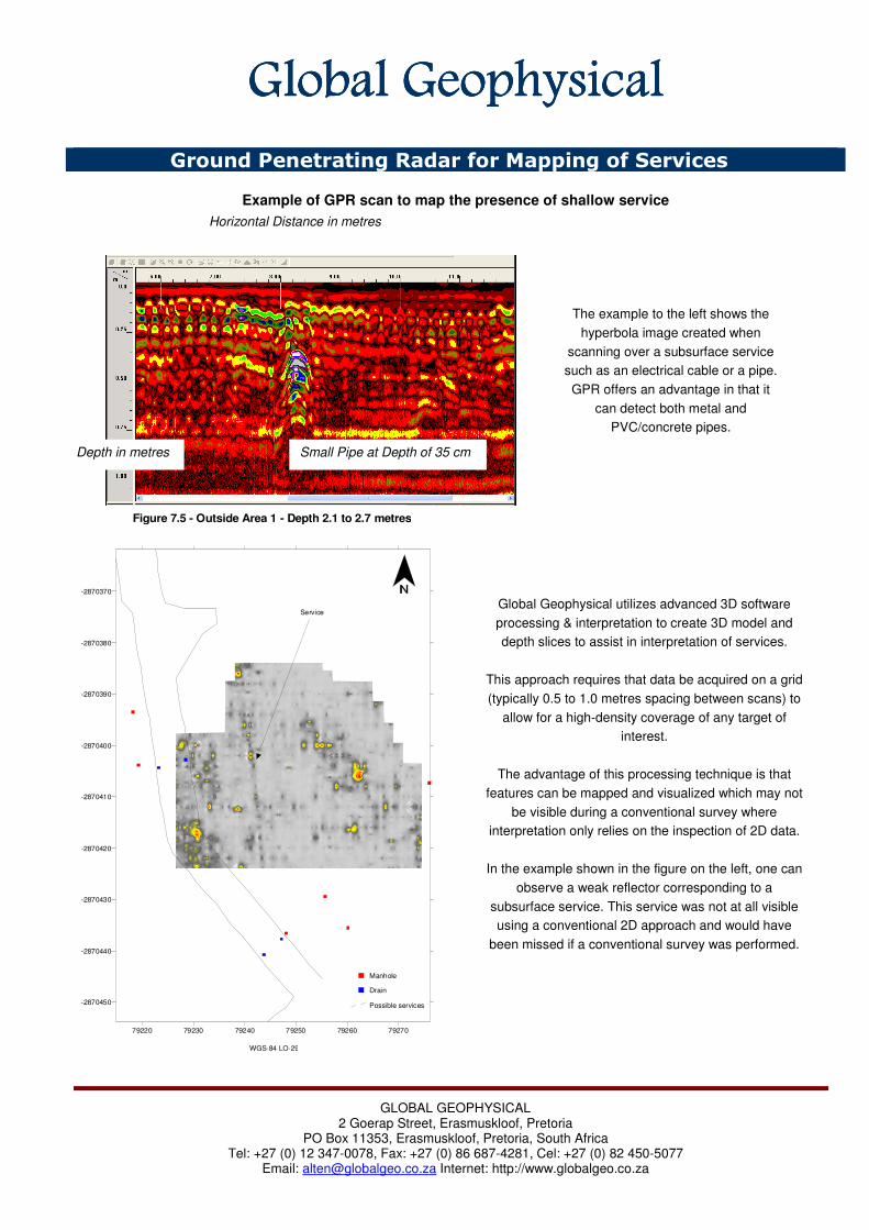
Ground Penetrating Radar for Mapping of Services
Example of GPR scan to map the presence of shallow service
GLOBAL GEOPHYSICAL
2 Goerap Street, Erasmuskloof, Pretoria PO Box 11353, Erasmuskloof, Pretoria, South Africa
Tel: +27 (0) 12 347-0078, Fax: +27 (0) 86 687-4281, Cel: +27 (0) 82 450-5077 Email: [email protected] Internet: http://www.globalgeo.co.za
Small Pipe at Depth of 35 cm Depth in metres
Horizontal Distance in metres
The example to the left shows the
hyperbola image created when
scanning over a subsurface service
such as an electrical cable or a pipe.
GPR offers an advantage in that it
can detect both metal and
PVC/concrete pipes.
79220 79230 79240 79250 79260 79270
-2870450
-2870440
-2870430
-2870420
-2870410
-2870400
-2870390
-2870380
-2870370
Figure 7.5 - Outside Area 1 - Depth 2.1 to 2.7 metres
WGS-84 LO-29
Manhole
Drain
Possible services
Service Global Geophysical utilizes advanced 3D software
processing & interpretation to create 3D model and
depth slices to assist in interpretation of services.
This approach requires that data be acquired on a grid
(typically 0.5 to 1.0 metres spacing between scans) to
allow for a high-density coverage of any target of
interest.
The advantage of this processing technique is that
features can be mapped and visualized which may not
be visible during a conventional survey where
interpretation only relies on the inspection of 2D data.
In the example shown in the figure on the left, one can
observe a weak reflector corresponding to a
subsurface service. This service was not at all visible
using a conventional 2D approach and would have
been missed if a conventional survey was performed.

Global GeophysicalGlobal GeophysicalGlobal GeophysicalGlobal Geophysical
Surface Waves for Shear Wave and Elastic Moduli Measurements
Multichannel Analysis of Surface Waves (MASW) is a relative new seismic approach to map shear wave velocity as a function of depth without the use of boreholes as required with borehole shear wave velocity measurements. The technique utilizes the dispersive nature of Surface Waves (also known as Rayleigh waves or Ground Roll), to determine shear wave velocity as a function of depth and distance. A shear wave velocity cross-section can be generated with shear wave velocities mapped for all layers of interest.
MASW offers the following advantages compared with Seismic Refraction and is often successful where Seismic Refraction has
failed:
• MASW utilizes high-energy surface waves and can be used in seismically noisy areas where Seismic Refraction body waves not have
sufficient signal to noise ratio for accurate first arrival picking.
• MASW does not suffer from velocity inversions and can be used in areas where a shallow high velocity layer underlain by softer
material makes Seismic Refraction unusable. For example, in areas of shallow calcrete underlain by softer sand before the deeper
bedrock layers, MASW will be able to map all the layers of interest.
• MASW can be used on tar/concrete surfaces without any problems where high velocity waves traveling through the upper surface may
interfere in normal Seismic Refraction studies.
• MASW offers improved lateral resolution compared with Seismic Refraction and may be used to map narrow faults and fracture zones.
Global Geophysical uses SurfSeis software developed by the Kansas Geological Survey which utilizes advanced processing tools
such as overtone analysis for proper selection of the fundamental Rayleigh mode. The use of a multi-channel approach allows for
a more quantitative analysis of surface waves.
TYPICAL APPLICATIONS
Mapping of Shear Wave Velocity
Bedrock Topography
Liquefaction Potential Studies
Mapping of Shear Modulus and other Elastic Moduli
Improved Site Characterization combining Shear with Compressional Wave Velocities
GLOBAL GEOPHYSICAL
2 Goerap Street, Erasmuskloof, Pretoria PO Box 11353, Erasmuskloof, Pretoria, South Africa
Tel: +27 (0) 12 347-0078, Fax: +27 (0) 86 687-4281, Cel: +27 (0) 82 450-5077 Email: [email protected] Internet: http://www.globalgeo.co.za
Multichannel Seimic Record
Advanced Overtone Analysis to distinguish between fundamental and
higher order Rayleigh modes and effective selection of only the
fundamental mode.
Inversion of Dispersion Curve to invert to shear
wave velocity from phase velocity.

Global GeophysicalGlobal GeophysicalGlobal GeophysicalGlobal Geophysical
Diamond Exploration
Global Geophysical employs a wide range of geophysical techniques for the location and delineation of Kimberlites and Alluvial
Diamond Deposits.
ALLUVIAL DIAMOND EXPLORATION
Other Geophysical Techniques Applicable to
Alluvial Diamond Exploration:
Resistivity, (Mapping of clay, gravel and bedrock
interfaces). Ground Penetrating Radar, (GPR), (Mapping depth to
bedrock in moderate conductive environments up to a
maximum depth of ± 30m).
Induced Polarisation, (Mapping of clay, gravel and bedrock
stratigraphy)
KIMBERLITE EXPLORATION
Other Geophysical techniques Applicable to
Kimberlite Exploration:
Micro Gravity Surveying, (Mapping depth of cover and
combined modeling of Magnetic and Gravity datasets).
Magnetotellurics (MT), (Mapping the orientation of the
kimberlite pipe and the delineation of it at great depths).
Seismic Refraction, (Mapping the depth of weathering with high
accuracy).
Electromagnetics, (EM), (Mapping of conductive overburden
and clays caused by weathering). Resistivity, (Mapping of resistive as well as conductive zones
associated with kimberlites). Induced Polarisation, (IP), (Measurement of the dispersive
effects caused by minerals such as clays or sulphides)
GLOBAL GEOPHYSICAL
2 Goerap Street, Erasmuskloof, Pretoria PO Box 11353, Erasmuskloof, Pretoria, South Africa
Tel: +27 (0) 12 347-0078, Fax: +27 (0) 86 687-4281, Cel: +27 (0) 82 450-5077 Email: [email protected] Internet: http://www.globalgeo.co.za
Using Micro-Gravity
surveying to delineate old
paleo-channels within
dolomite bedrock.
High resolution Ground
Magnetic Surveying to
locate and model
Kimberlite Pipe.
Target areas visible
as blue end of the
anomaly spectrum.
Kimberlite Center
Modeling capabilities
of magnetic datasets
and derivations of
key variables, such
as, depth to top of
kimberlite, width of
kimberlite and the
general shape of the
pipe.

Global GeophysicalGlobal GeophysicalGlobal GeophysicalGlobal Geophysical
Gold Exploration
Native gold has highly unusual physical properties, e.g., it has the
highest specific gravity of any natural material and is an excellent
conductor of electricity, it is present at best in amounts of a few
parts per million by volume and therefore cannot be directly
detected in-situ by any known geophysical methods.
Thus, those geophysical methods which offer the possibility of
being used in the exploration for gold deposits fall back on less
direct approaches, for example, the structural relationship of gold
deposits (using magnetics and gravity) and the detection of
associated or pathfinder minerals which may be present in much
larger amount than the gold itself.
Other Geophysical Techniques Applicable to Gold Exploration:
• Gravity
• Seismic Refraction - (Mapping buried river channels for placer gold deposits).
• Resistivity - (Mapping of conductive sulfides and mapping of resistive near surface zones of silification associated
with gold mineralisation.
• Induced Polarisation - (Mapping of metallic sulfides and quartz veins).
• Electromagnetics (EM) - Used where massive sulfides, conductive faults or fracture zones, or more resistive
silicified rocks may be associated with gold mineralisation.
GLOBAL GEOPHYSICAL
2 Goerap Street, Erasmuskloof, Pretoria PO Box 11353, Erasmuskloof, Pretoria, South Africa
Tel: +27 (0) 12 347-0078, Fax: +27 (0) 86 687-4281, Cel: +27 (0) 82 450-5077 Email: [email protected] Internet: http://www.globalgeo.co.za
Ground Magnetic Surveying is a
rapid and cost effective tool for
mapping local geology and
intrusions.
0 50 100 150 200 250 300 350 400 450 500 550 600 650 700 750 800
Line Chainage (m)
900
950
1000
1050
1100
1150
1200
1250
1300
1350
1400
Ele
va
tion (
m)
50
100
150
200
250
300
350
400
450
500
550
600
650
700
750
800
850
900
950
1000
1050
Resis
tivi
ty (
ohm
.m)
Conductive Zone coinciding with a
mapped magnetic lineament
Conductive Zone coinciding with
localized quartzite outcrop
Conductive Zone,(Associated with sulfide
mineralisation)Possible fault
location
Known DykePosition
Magnetotellurics (MT) is a state-of-the-art
geophysical technique used to image the
subsurface at great depths. The figure (left)
depicts the change in resistivity with depth. The
blue end of the color scale represents conductive
zones and the red/purple end of the color sale
represents resistive zones.
Linear Magnetic anomalies are
usually caused by dykes, in this
case these dykes may be
associated with gold mineralisation,
the pole reversal, (red and blue),
indicates an age difference.