GLENS FALLS MM S. Route 9 bridge spanning the Hudson River
51
GLENS FALLS MM HAER No. NY-270 100 to 450 fe«t west of the U. S. Route 9 bridge spanning the Hudson River i Glens Falls H/fep* Warren County ** "-'**- New York fly PHOTOGRAPHS WRITTEN HISTORICAL AND DESCRIPTIVE DATA HISTORIC AMERICAN ENGINEERING RECORD National Park Service Northeast Region U. S. Custom House 200 Chestnut Street Philadelphia, PA 19106
Transcript of GLENS FALLS MM S. Route 9 bridge spanning the Hudson River

GLENS FALLS MM HAER No. NY-270 100 to 450 fe«t west of the U. S. Route 9 bridge
spanning the Hudson River i Glens Falls H/fep* Warren County ** "-'**- New York fly
PHOTOGRAPHS
WRITTEN HISTORICAL AND DESCRIPTIVE DATA
HISTORIC AMERICAN ENGINEERING RECORD National Park Service
Northeast Region U. S. Custom House 200 Chestnut Street
Philadelphia, PA 19106

Location:
I- HISTORIC AMERICAN ENGINEERING RECORD
GLENS FALLS DAM HAER No. NY-270 V
100 to 450 feet west of the U. S. Route 9 bridge spanning the Hudson River Glens Falls, Warren County, New York
UTM: 18.610140.4795370 Glens Falls Quadrangle, New York 1:24,000
Date of Construction:
Initial construction: 1913-1915 Raised: 1923-24
Engineer: Not Known
Present Owner: Niagara Mohawk Power Corporation 300 Salina Boulevard Syracuse, New York
and Finch, Pruyn & Company, Inc. Glen Street Glens Falls, New York
Present Use: Hydroelectric generation
Significance: The 1913 Glens Falls Dam is architec a remarkably intact example of dam construction which reflects early twentieth century design and technology. The Dam once played an important role in the local industrial economy of the Glens Falls area by providing hydropower potential for the paper mills and other industries situated on both sides of the Hudson River. Still important today, the dam is used exclusively for electrical generation. Cooper's Cave, located 500 feet downstream from the Glens Falls Dam, was the setting for an action-filled scene at the beginning of James F. Cooper's nineteenth century novel of life on the colonial frontier, The Last of the Mohicans.
Project Information: A 1991 evaluation of the dam resulted in a directive mandating its redevelopment. As part of mitigating the adverse effects of redevelopment, the State Historic Preservation Office stipulated HAER documentation of both the existing structure and Cooper's Cave prior to the commencement of redevelopment. This HAER documentation was undertaken to fulfill that stipulation.
Jay W. Bouchard Hartgen Archeological Associates, Inc. 27 Jordan Road Troy, New York 12180

•
Glens Falls Dam HAERNo. NY-270 (Page 2)
INTRODUCTION
•
Historic American Engineering Record documentation has been undertaken for the Glens Falls Dam and Cooper's Cave. Although technically unassociated features, the Glens Falls Dam and Cooper's Cave lie within about 500 feet of one another, with the cave lying downstream from the dam. The owners of the Glens Falls Dam propose to redevelop the dam as part of compliance with a Federal Energy Regulatory Commission rinding. National Parks Service staff established the level of documentation for the Glens Falls Dam, which will be impacted by redevelopment, and Cooper's Cave, which will not be impacted by dam redevelopment. Documentation is provided below first for the Glens Falls Dam followed by documentation for Cooper's Cave.
The 1913 concrete Glens Falls Dam is one of a minimum of three structures to have spanned the Hudson River at Glens Falls from the late eighteenth to the twentieth centuries. The Glens Falls dams provided waterpower for a number of extractive industries that developed on both sides of the river. From the last half of the eighteenth century to the present, the list of industries that used waterpower from the dam included saw mills; grist mills; limestone or "marble" sawmills; a trip hammer; cotton factories; spoke and hub factories, sash and door factories, planing and turning mills, plaster mills, and paper mills. Today, two paper mills and a hydroelectric generating station are situated in the vicinity of the falls. The Finch, Pruyn & Company paper mill on the north side of the Hudson River and the Niagara Mohawk Power Corporation hydroelectric generating station on the south side share the flow of Hudson River water impounded behind the dam. The Encore Paper Company uses water from the Hudson River in the paper making process, but does not share in the hydropower potential of the dam. The Glens Falls Dam was built in 1913 by Finch, Pruyn & Company, a large locally-owned paper mill in Glens Falls on the north side of the Hudson River, and International Paper Company, a large company that today owns many paper mills in New York State and elsewhere in the United States. International Paper Company through its subsidiary International Hydroelectric Company, sold its interest in the South Glens Falls hydroelectric plant to Niagara Mohawk Corporation, a New York public utility, in 1953. Today, the dam is owned jointly by Finch, Pruyn & Company and Niagara Mohawk Power Corporation.
GEOGRAPHIC SETTING
Geographically, the City of Glens Falls, Warren County, New York; the Glens Falls Dam; and Cooper's Cave are all located in the Hudson Valley section of the St. Lawrence-Champlain Lowland. To the east lies the Taconic Mountains of the New England Uplands and to the west and north lies the Adirondack Low Mountains subregion of the Adirondack Uplands (Thompson 1966, Figure 9). The communities of Glens Falls and South Glens Falls are located on a major bend in the Hudson River. Glens Falls is in Warren County which is on the north side of the river. South Glens Falls is on the south side of the Hudson; it is in Saratoga County.
The primary bedrock of the area is Canajoharie shale, a member of the Middle and Upper Ordovician Lorraine, Trenton and Black River Group (Fisher, Isachsen, and Rickard 1970). In

•
Glens Falls Dam HAERNo. NY-270 (Page 3)
the vicinity of the Glens Falls Dam, the river bed lies on a band of Trenton and Black River Group Glens Falls Limestone. While the Canajoharie shale erodes readily, the Glens Falls limestone is somewhat more resistant to the action of water. It is for this reason that the falls at Glens Falls formed.
The Glens Falls limestone is an economically significant resource and historically has been used for building stone (foundations), architectural stone (floor tiling, mantels, wainscoting, table tops and other interior decorative work), burning for lime (for plaster and mortar and, possibly, for agricultural and other purposes as well), crushed stone, and portland cement (Newland 1916, 203; Ries 1901, 815, 816; Eckel 1901, 849, 850, 858, 859, 866-868). Although all of the uses were important to the Glens Falls economy in the past, only the crushed stone and portland cement industries survive today (King 1978, 56, 57).
GENERAL DESCRIPTION AND LOCATION OF THE GLENS FALLS DAM AND ASSOCIATED FEATURES
The Glens Falls Dam is situated at the head of Glens Falls on the Hudson River, a natural rock descent over Glens Falls limestone (WIDE-ANGLE VIEW OF THE GLENS FALLS DAM etc.; WEST-SOUTHWEST VIEW OF THE GLENS FALLS DAM AS SEEN FROM DOWNSTREAM BELOW THE GLENS FALLS BRIDGE; ACRES International Corporation drawing number 10084EC.002). The top of the falls is at an elevation of approximately 256 feet. A descent of 36 feet of the limestone bedrock occurs over a horizontal distance of 200 to 320 feet, culminating in a pool at the bottom of the falls with an elevation of 220 feet. Two channels have developed at the falls. The secondary channel lies toward the south side of the Hudson River. The main channel is closer to the north side of the river. Since the main channel carries more water than the secondary channel, it has eroded upstream at a faster rate. Therefore, the falls begin farther upstream on the north side of the river than on the south side. This difference in erosion rates has determined the position and shape of the Glens Falls Dam. Instead of being a single straight-line structure perpendicular to the water's flow, and spanning the river from bank to bank, the Glens Falls Dam is constructed in three sections that follow the arc of the highest part of the bedrock at the top of the falls.
The concrete Glens Falls Dam structure ranges from about nine to 13 feet high including five-foot high wooden flashboards along the top (Sheet 1-258, International Paper Company; Sheet 1-473, International Paper Company; Sheet 513-AX, Niagara Mohawk Power Corporation). The dam is 445 feet long and consists of three linear sections joined by massive angle joints. From south to north, the three sections are 70 feet, 235 feet, and 140 feet long. The Niagara Mohawk Power Corporation headgates at the south end of the dam are 120 feet long. The Finch, Pruyn & Company headgates and a short wing dam at the north end of the Glens Falls Dam are 180 feet long. The linear sections of the dam include 45, five to approximately eight foot high romanesque arches. The arches are eight feet deep and six feet wide. The dam is 15 feet wide at the base and four feet wide at the top. As originally designed, flashboards added an additional three feet to the height of the dam (Sheet 1-260, Finch, Pruyn & Company and International Paper Company. Today, the flashboards are five feet high.
Glens Falls Dam HAERNo. NY-270 (Page 4)
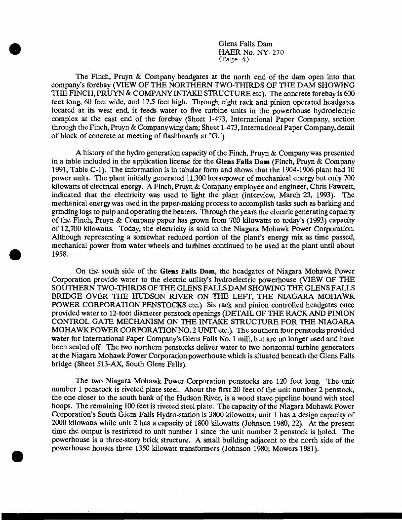
The Finch, Pruyn & Company headgates at the north end of the dam open into that company's forebay (VIEW OF THE NORTHERN TWO-THIRDS OF THE DAM SHOWING THE FINCH, PRUYN & COMPANY INTAKE STRUCTURE etc). The concrete forebay is 600 feet long, 60 feet wide, and 17.5 feet high. Through eight rack and pinion operated headgates located at its west end, it feeds water to five turbine units in the powerhouse hydroelectric complex at the east end of the forebay (Sheet 1-473, International Paper Company, section through the Finch, Pruyn & Company wing dam; Sheet 1-473, International Paper Company, detail of block of concrete at meeting of flashboards at "G.")
A history of the hydro generation capacity of the Finch, Pruyn & Company was presented in a table included in the application license for the Glens Falls Dam (Finch, Pruyn & Company 1991, Table C-l). The information is in tabular form and shows that the 1904-1906 plant had 10 power units. The plant initially generated 11,300 horsepower of mechanical energy but only 700 kilowatts of electrical energy. A Finch, Pruyn & Company employee and engineer, Chris Fawcett, indicated that the electricity was used to light the plant (interview, March 23, 1993). The mechanical energy was used in the paper-making process to accomplish tasks such as barking and grinding logs to pulp and operating the beaters. Through the years the electric generating capacity of the Finch, Pruyn & Company paper has grown from 700 kilowatts to today's (1993) capacity of 12,700 kilowatts. Today, the electricity is sold to the Niagara Mohawk Power Corporation. Although representing a somewhat reduced portion of the plant's energy mix as time passed, mechanical power from water wheels and turbines continued to be used at the plant until about 1958.
On the south side of the Glens Falls Dam, the headgates of Niagara Mohawk Power Corporation provide water to the electric utility's hydroelectric powerhouse (VIEW OF THE SOUTHERN TWO-THIRDS OF THE GLENS FALLS DAM SHOWING THE GLENS FALLS BRIDGE OVER THE HUDSON RIVER ON THE LEFT, THE NIAGARA MOHAWK POWER CORPORATION PENSTOCKS etc.) Six rack and pinion controlled headgates once provided water to 12-foot diameter penstock openings (DETAIL OF THE RACK AND PINION CONTROL GATE MECHANISM ON THE INTAKE STRUCTURE FOR THE NIAGARA MOHAWK POWER CORPORATION NO. 2 UNIT etc.). The southern four penstocks provided water for International Paper Company's Glens Falls No. 1 mill, but are no longer used and have been sealed off. The two northern penstocks deliver water to two horizontal turbine generators at the Niagara Mohawk Power Corporation powerhouse which is situated beneath the Glens Falls bridge (Sheet 513-AX, South Glens Falls).
The two Niagara Mohawk Power Corporation penstocks are 120 feet long. The unit number 1 penstock is riveted plate steel. About the first 20 feet of the unit number 2 penstock, the one closer to the south bank of the Hudson River, is a wood stave pipeline bound with steel hoops. The remaining 100 feet is riveted steel plate. The capacity of the Niagara Mohawk Power Corporation's South Glens Falls Hydro-station is 3800 kilowatts; unit 1 has a design capacity of 2000 kilowatts while unit 2 has a capacity of 1800 kilowatts (Johnson 1980, 22). At the present time the output is restricted to unit number 1 since the unit number 2 penstock is holed. The powerhouse is a three-story brick structure. A small building adjacent to the north side of the powerhouse houses three 1350 kilowatt transformers (Johnson 1980; Mowers 1981).

Glens Falls Dam HAERNo. NY-270 (Page 5)
A concrete log chute passes through the dam about 75 feet south of its north end. The chute is an original component of the dam's design (THE LOG CHUTE IN THE GLENS FALLS DAM; A CLOSEUP VIEW OF THE LOG CHUTE SHOWING THE TURN BELOW THE GLENS FALLS DAM). Downstream from the dam were two log ponds which also had concrete log chutes of similar concrete construction (Sheet 1-258, International Paper Company and Finch, Pruyn & Company; Sheet 1-473, International Paper Company). During log drives, the log chute in the dam and the log ponds below the dam provided a passageway for logs in the main channel of the Hudson River. The log chute at the dam was angled slightly to the north to direct logs toward the upper log pond. After passing through the log ponds and chutes, the logs continued downstream to paper mills located at the communities of Hudson Falls and Fort Edward.
The log chutes are trapezoidal in outline with nearly vertical outside walls and sloping inside walls. The concrete has weathered since the chutes were installed in 1913-1916 thus reducing somewhat their dimensions. Present-day measurements of the log chute in the Glens Falls Dam show that each wall is 19 to 20 inches across the top, 33 inches across the bottom, and 34 inches high. The two sides of the log chute form a trough that is 66 inches wide and 60 feet long. Blocked at the dam, little water now flows through the chute. The log drives for which the log chute and log ponds were constructed ceased in 1950 (King 1978, 62).
The concrete sides of the lower log pond are splayed to funnel logs to the downstream end (UPSTREAM VIEW SHOWING THE LOWER LOG POND LOG CHUTE IN THE MAIN CHANNEL OF THE HUDSON RIVER; THE LOWER LOG POND AND LOG CHUTE). The northern section has partly eroded away, and only iron anchors survive. Also trapezoidal in outline, similar to the log chute in the Glens Falls Dam, the height of the lower log pond chute varies from 18 inches at the upstream end to 42 inches at the downstream end. Likewise, the top of the chute walls are 18 inches wide upstream and 24 inches wide at the downstream end. The width of the log pond chute is 60 feet at the upstream end; the downstream opening is 15 feet wide.
A comparison of the 1913 and 1923 plans of the Glens Falls Dam with plans showing existing conditions in 1963 demonstrates that the only significant alteration was the heightening of the dam by a little more than three feet that occurred in 1923 and 1924 (compare typical cross sections through the dam on Sheet 1-258, International Paper Company and Finch, Pruyn & Company; Sheet 1-260, Finch, Pruyn & Company and International Paper Company; and Sheet 1-473, International Paper Company). How this was accomplished is shown on both the 1913 and 1923 plans. A note on the 1913 plan states that the three 12-inch square timbers that anchored planking to the top of the dam were to be removed before the heightening was undertaken. According to Chris Fawcett, Finch, Pruyn & Company civil engineer (interview, March 23,1993), the timbers were not removed before the dam was heightened. Personal observation by the writer confirms that timbers can be seen at the tops of some arches where the concrete has spalled. Other than heightening the dam by three feet, the only other alteration was to increase the height of the flashboards on top of the dam from three feet to five feet.
Several people who might have information about who designed the the Glens Falls Dam were interviewed. Included in the list were Chris Fawcett of Finch, Pruyn & Company (Interview,

Glens Falls Dam HAERNo. NY-270 (Page 6)
March 23, 1993); the engineering and design firm of Parsons-Brinckerhoff in New York (a company associated with the large early twentieth century Spier Falls hydroelectric project on the Hudson River-interview, Marsha Herman, April 1,1993); and a retired officer of the Glens Falls Cement Company (telephone interview, Burt Keene, April 1 and 8,1993), a likely provider of the concrete used in construction of the dam. None of these people could provide information about who designed the Glens Falls Dam. The ink on linen drawings which are included in this report bear the company name "International Paper Company," and the name of the draftsman and checker, but the engineer who designed the dam is not mentioned. Likewise, no information was available about the labor force or construction company that erected the Glens Falls Dam. Nor was this information available in any of the published works examined for this report.
THE ENGINEERING OF THE GLENS FALLS DAM by Frank E. Griggs, Ph.D.
The Glens Falls Dam was built in 1913 to replace a nineteenth century timber-framed dam that was located immediately upstream. Wooden dams on rivers and small streams were common in the United States. They were usually built to create mill ponds to run water wheels or turbines which in turn power machinery in the mills. The two standard wooden dams were cribs filled with rock or timber-framed. Wood crib dams were usually built on streams with sandy bottoms; timber-framed dams were used on rivers where bedrock was exposed on the streambed. If a wood frame dam was located on a streambed of bedrock, wood sills would be doweled to the stream bed with compression struts supporting a wooden barrier. A cross section of a typical wood frame dam is shown on the Figure entitled WOODEN DAM. Usually, fine-grained soil was placed on the lower portion of the upstream face of the dam to minimize leakage through the wooden barrier. ITie sloping upstream face was very flat so that the weight of the water on the dam contributed to greater overturning and sliding resistance.
Masonry gravity dams were developed in Europe and were built in the United States in the nineteenth and early twentieth centuries. This type of dam relied on its mass to prevent the dam from overturning or sliding downstream under the action of fluid pressure on the vertical, or near vertical, front face of the dam. This type of dam also used the mass of the masonry to prevent tension from developing between the stone blocks so that overturning or sliding of the upper portion of the dam with respect to the lower portion would not occur. The Spier Falls Dam, located on the Hudson River about six miles upstream from the Glens Falls Dam, was constructed in 1905 with the cross section of the dam and spillway shown in figures labeled SPIER FALLS DAM PROFILES. This dam was built of cyclopean concrete, that is, concrete packed around large rocks and boulders. This construction technique is similar to the one used in building the Croton Dam north of New York City. The cement for this dam was hauled from Glens Falls by teams of horses and all of the stone and aggregate were found within 12 miles of the site with the facing stone coming from Hadley just upstream from Glens Falls. The forces working on a gravity dam are shown in the figure called ILLUSTRATION OF MOMENTS AND SLIDING FORCES. The greatest depth of the dam is on the upstream portion. This gives the maximum moment arm about the toe of the dam to resist the overturning moment of the water against the dam.

Glens Falls Dam HAERNo. NY-270 (Page 7)
When concrete started to replace stone as the favored material of construction for gravity dams, the same profiles were adopted as were used for stone dams, even though the shear and tensile strength of the concrete eliminated, to a degree, the danger of tension cracks occurring on the upstream face. These dams were generally built of unreinforced concrete.
The last type of dam used was the buttress dam which is much like the wooden frame dam in concept. Buttresses of concrete were poured and anchored to the stream bedrock by keying them into the rock in excavated slots and/or doweling them to the stream bed. Then, either concrete plank or curved concrete panels were poured between the buttresses. This is similar to the methods used on the concrete dam at Sherman Island built a decade later a few miles upstream from the Glens Fa Ills Dam. Cross sections of the Sherman Island dam are presented on the figure called SHERMAN ISLAND DAM. The Sherman Island dam was built of reinforced concrete with the upstream face in two segments. The lower segment was on a slope of 5 on 12 with the upper segment on a 1 on 1 slope. The designer of both the Spier Falls and Sherman Island dams was H. deB. Parsons, a professor at Rensselaer Polytechnic Institute in Troy, New York.
It was in the evolving local, national, and international milieu of dam-building design and technology of the early twentieth century that the Glens Falls Dam was built in 1913. The builders of the Glens Falls Dam apparently were attempting to build a buttress dam of unreinforced concrete. Romanesque arch "cutouts" are an integral component of the dam; they consist of the semicircular arches and vertical sections below the arches. The cutouts on the downstream face of the dam left three foot wide ribs in place which acted like buttresses. The cutouts were poured monolithic with the actual impervious concrete barrier of the dam. This barrier was also at an unusual angle since it was too steep to rely on the weight of the water acting on the dam to give much additional stability. The buttresses were cast in recesses in the rock and doweled to the river bottom in the conventional manner. Given the tendency of concrete to shrink while curing, the cutouts created significant opportunities for cracking to occur both at each intersection of the curved top portion of the cutout with the vertical faces of the cutouts and between the 12x12 inch timbers and the cutouts. The dam was poured in complete segments (the buttress and the dam face poured together at the same time), varying in depth as the streambed changed in elevation. Great care was later taken in the Sherman Island Dam to pour the concrete in segments so as to minimize the cracking problem, possibly as a result of the experience on the Glens Falls Dam.
The Glens Falls Dam was built in two phases with the second 1923-24 phase consisting of heightening the original 1913 dam by a little more than three feet. The top face of the first phase of the dam had three large 12x12 inch timbers cast into the concrete. A wooden surface was then nailed to these timbers to protect the concrete from abrasion by debris passing over the dam. These members were much larger than needed to serve as nailers, so it is apparent that the designers of the first phase of the dam planned on using the slots formed, when the nailers were removed, as keyways for the second phase of the dam. A note on the September 23, 1913, drawing indicates that the designers were planning an extension to the top of the dam made from either rock and crib design or concrete (see the photographic copy of engineering drawing 1-258, detail showing cross sections through the dam). In either case, the slots would have been needed

Glens Falls Dam HAERNo. NY-270 (Page 8)
to anchor the extension to the lower portion of the dam. In addition to the three keyways on the top of the original dam, additional 1 1/2 inch square twist bars were doweled to the rock and to the lower portion of the dam to bond the upper portion to the lower part. The forces acting on the Glens Falls Dam for both phases are shown in the figure entitled FORCES WORKING ON THE GLENS FALLS DAM.
The wooden flashboards on top of the dam were then set into inserts cast in the concrete to increase the water level behind the dam by three feet. The total height of the Glens Falls Dam when completed with flashboards varied from shore to shore but was in the range of nine to 13 feet.
The design of the Glens Falls Dam is unusual in that it is neither a gravity dam, or a true buttress dam, at least in the style typical of the period. Given the unusual design of the dam, it may be possible that the plan was made by plant engineers associated with the Finch, Pruyn & Company or the International Paper Company. The drawings do not indicate the name of the designer, only the names of the draftsman, checker, and, where appropriate, the tracer. As a dam, therefore, it does not appear to have been engineered in the usual sense by an engineer who specialized in dam design and construction. The dam, however, lasted for over 80 years and, as a result, is testimony to the intuition of its designers and builders.
The Glens Falls Dam, therefore, while a functional success, can not be considered a reflection of the technology and design of the early twentieth century. Instead, it appears to have been the design of an individual, or individuals, who attempted to design a wood frame dam in concrete and, while successful, was not duplicated elsewhere or described in the literature of the time. It did not contribute to the advancement of dam design, either in the region or nationally.
RELATIONSHIP OF THE GLENS FALLS DAM TO OTHER NEW YORK DAMS
Duncan Hay's 1991A History of Hydroelectric Power in New York State was examined to determine how the Glens Falls Dam compared with other dams in the state. Hay collected information on approximately 250 operating and retired hydroelectric facilities in New York. Some of these were designed as hydroelectric dam structures; others, similar to the Glens Falls Dam, were converted from industrial uses to hydroelectric generation. The basic designs for New York hydroelectric dams are gravity and multiple arch buttress types, as discussed in the engineering section above. In Hay's study, when the type of dam was listed, there were, excluding the Glens Falls Dam, at least nine dams described as concrete arch or concrete multiple arch. None of these resembles the Glens Falls Dam. The Glens Falls Dam appears to be a unique design, at least within New York state.

Glens Falls Dam HAERNo. NY-270 (Page 9)
HISTORIC VIEWS OF THE GLENS FALLS DAM
A series of five historic photographs dating from 1909 and 1913 documents the condition and destruction of the interlocking timber dam that was the predecessor of the 1913 Glens Falls Dam. The pictures also show the aftermath of the flood that destroyed the pre-1913 dam, and the construction of the concrete Glens Falls Dam that is the subject of their HAER documentary report. These photographs are copies of original contact prints with dimensions of 6x29 inches. The photographs are discussed below.
Conditions as they were in 1909 are shown in the first photograph of the series (PANORAMIC VIEW EAST TO SOUTHWEST OF THE GLENS FALLS DAM TAKEN FROM THE WEST END OF THE FINCH, PRUYN & COMPANY INTAKE STRUCTURE). The view was taken from the Finch, Pruyn & Company intake structure. It shows the Finch, Pruyn & Company forebay on the left and proceeding around to the right shows, in succession, the Glens Falls bridge, the International Paper Company's Glens Falls Mill No. 1 on the south bank of the Hudson River, and the pre-1913 interlocking timber Glens Falls dam. The series of square structures in the Hudson River above the dam are part of the complex boom system that was used to sort and control the movement of logs during log drives. Many logs from the previous year's log drive are scattered over the bedrock in front of the dam.
The second historic view was taken on March 28,1913, from the roof of the Finch, Pruyn & Company powerhouse downstream from the Glens Falls bridge (PANORAMIC VIEW OF THE HUDSON RIVER AT GLENS FALLS DURING THE MARCH 1913 FLOOD etc.). It shows the near-record flood of that year. The bridge is not visible because the flood had washed it away on March 27 along with part of the pre-1913 interlocking timber Glens Falls dam.
The third historic view was taken at the end of June 1913 (PANORAMIC VIEW EAST TO SOUTHWEST OF THE GLENS FALLS DAM AFTER THE 1913 FLOOD etc.). This is a view from the same perspective as the first one. It shows the aftermath of the 1913 flood. On the left, the Glens Falls bridge has been temporarily replaced by two structures; the first is a footbridge near the level of the river. Above it is a temporary bridge for vehicular traffic. The temporary bridge is still being erected. On the right, the central part of the dam has been washed away. It was the 1913 flood that precipitated the replacement of the pre-1913 interlocking timber Glens Falls dam. Note that the Finch, Pruyn & Company intake structure on the left and the International Paper Company intake structure (later to become the Niagara Mohawk Power Corporation intake structure) in the background are already in place before construction of the concrete Glens Falls Dam commences.
The fourth historic photograph documenting the genesis of the concrete 1913 Glens Falls Dam is a view taken upstream from the pre-1913 interlocking timber dam (PANORAMIC VIEW NORTHEAST TO SOUTHEAST OF THE GLENS FALLS DAM UNDER CONSTRUCTION). The old dam was used as a coffer during the construction of the new dam. It is dated September 15,1913, and shows the Hudson River during a period of low flow. Represented are the upstream sides of forms used in pouring the 1913 concrete Glens Falls Dam. The forms are in various stages of construction. On the left side of the picture the forms appear to be nearly complete as
Glens Falls Dam HAER No. NY- 270 (Page 10)
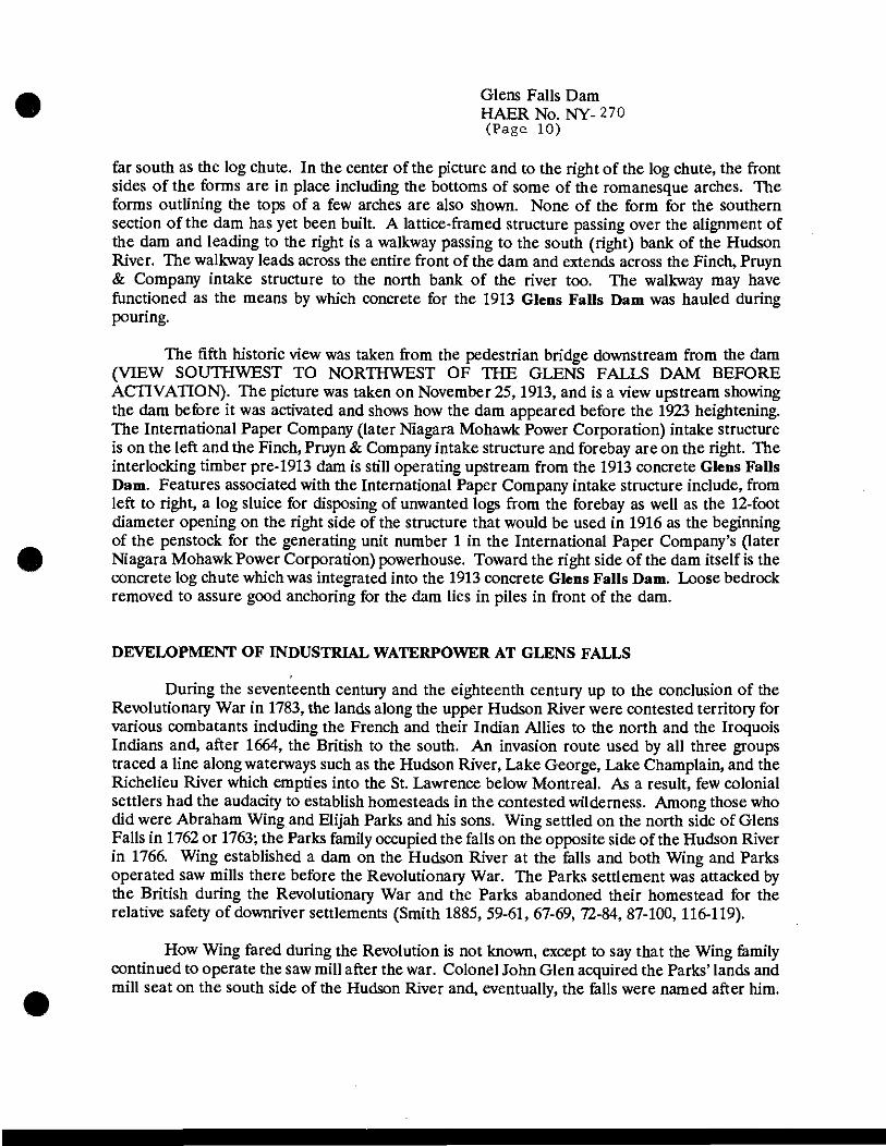
far south as the log chute. In the center of the picture and to the right of the log chute, the front sides of the forms are in place including the bottoms of some of the romanesque arches. The forms outlining the tops of a few arches are also shown. None of the form for the southern section of the dam has yet been built. A lattice-framed structure passing over the alignment of the dam and leading to the right is a walkway passing to the south (right) bank of the Hudson River. The walkway leads across the entire front of the dam and extends across the Finch, Pruyn & Company intake structure to the north bank of the river too. The walkway may have functioned as the means by which concrete for the 1913 Glens Falls Dam was hauled during pouring.
The fifth historic view was taken from the pedestrian bridge downstream from the dam (VIEW SOUTHWEST TO NORTHWEST OF THE GLENS FALLS DAM BEFORE ACTIVATION). The picture was taken on November 25,1913, and is a view upstream showing the dam before it was activated and shows how the dam appeared before the 1923 heightening. The International Paper Company (later Niagara Mohawk Power Corporation) intake structure is on the left and the Finch, Pruyn & Company intake structure and forebay are on the right. The interlocking timber pre-1913 dam is still operating upstream from the 1913 concrete Glens Falls Dam. Features associated with the International Paper Company intake structure include, from left to right, a log sluice for disposing of unwanted logs from the forebay as well as the 12-foot diameter opening on the right side of the structure that would be used in 1916 as the beginning of the penstock for the generating unit number 1 in the International Paper Company's (later Niagara Mohawk Power Corporation) powerhouse. Toward the right side of the dam itself is the concrete log chute which was integrated into the 1913 concrete Glens Falls Dam. Loose bedrock removed to assure good anchoring for the dam lies in piles in front of the dam.
DEVELOPMENT OF INDUSTRIAL WATERPOWER AT GLENS FALLS
During the seventeenth century and the eighteenth century up to the conclusion of the Revolutionary War in 1783, the lands along the upper Hudson River were contested territory for various combatants including the French and their Indian Allies to the north and the Iroquois Indians and, after 1664, the British to the south. An invasion route used by all three groups traced a line along waterways such as the Hudson River, Lake George, Lake Champlain, and the Richelieu River which empties into the St. Lawrence below Montreal. As a result, few colonial settlers had the audacity to establish homesteads in the contested wilderness. Among those who did were Abraham Wing and Elijah Parks and his sons. Wing settled on the north side of Glens Falls in 1762 or 1763; the Parks family occupied the falls on the opposite side of the Hudson River in 1766. Wing established a dam on the Hudson River at the falls and both Wing and Parks operated saw mills there before the Revolutionary War. The Parks settlement was attacked by the British during the Revolutionary War and the Parks abandoned their homestead for the relative safety of downriver settlements (Smith 1885, 59-61, 67-69, 72-84, 87-100, 116-119).
How Wing fared during the Revolution is not known, except to say that the Wing family continued to operate the saw mill after the war. Colonel John Glen acquired the Parks' lands and mill seat on the south side of the Hudson River and, eventually, the falls were named after him.
Glens Falls Dam HAERNo.NY-270 (Page 11)
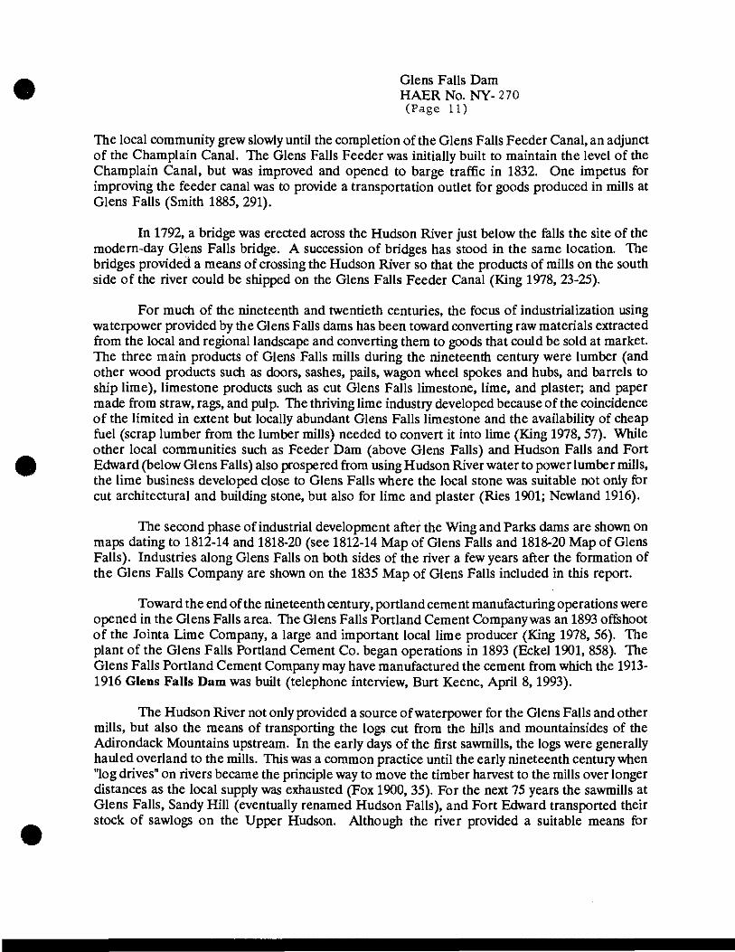
The local community grew slowly until the completion of the Glens Falls Feeder Canal, an adjunct of the Champlain Canal. The Glens Falls Feeder was initially built to maintain the level of the Champlain Canal, but was improved and opened to barge traffic in 1832. One impetus for improving the feeder canal was to provide a transportation outlet for goods produced in mills at Glens Falls (Smith 1885, 291).
In 1792, a bridge was erected across the Hudson River just below the falls the site of the modern-day Glens Falls bridge. A succession of bridges has stood in the same location. The bridges provided a means of crossing the Hudson River so that the products of mills on the south side of the river could be shipped on the Glens Falls Feeder Canal (King 1978, 23-25).
For much of the nineteenth and twentieth centuries, the focus of industrialization using waterpower provided by the Glens Falls dams has been toward converting raw materials extracted from the local and regional landscape and converting them to goods that could be sold at market. The three main products of Glens Falls mills during the nineteenth century were lumber (and other wood products such as doors, sashes, pails, wagon wheel spokes and hubs, and barrels to ship lime), limestone products such as cut Glens Falls limestone, lime, and plaster; and paper made from straw, rags, and pulp. The thriving lime industry developed because of the coincidence of the limited in extent but locally abundant Glens Falls limestone and the availability of cheap fuel (scrap lumber from the lumber mills) needed to convert it into lime (King 1978,57). While other local communities such as Feeder Dam (above Glens Falls) and Hudson Falls and Fort Edward (below Glens Falls) also prospered from using Hudson River water to power lumber mills, the lime business developed close to Glens Falls where the local stone was suitable not only for cut architectural and building stone, but also for lime and plaster (Ries 1901; Newland 1916).
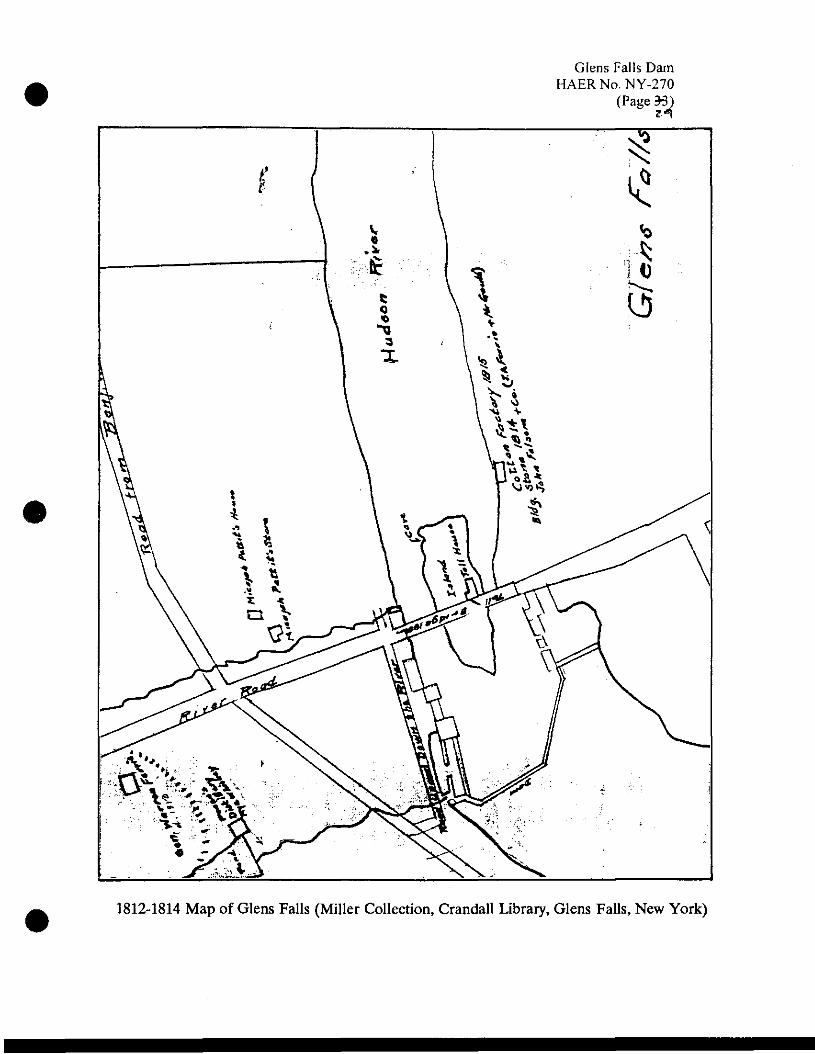
The second phase of industrial development after the Wing and Parks dams are shown on maps dating to 1812-14 and 1818-20 (see 1812-14 Map of Glens Falls and 1818-20 Map of Glens Falls). Industries along Glens Falls on both sides of the river a few years after the formation of the Glens Falls Company are shown on the 1835 Map of Glens Falls included in this report.
Toward the end of the nineteenth century, portland cement manufacturing operations were opened in the Glens Falls area. The Glens Falls Portland Cement Company was an 1893 offshoot of the Jointa Lime Company, a large and important local lime producer (King 1978, 56). The plant of the Glens Falls Portland Cement Co. began operations in 1893 (Eckel 1901, 858). The Glens Falls Portland Cement Company may have manufactured the cement from which the 1913- 1916 Glens Falls Dam was built (telephone interview, Burt Keene, April 8, 1993).
The Hudson River not only provided a source of waterpower for the Glens Falls and other mills, but also the means of transporting the logs cut from the hills and mountainsides of the Adirondack Mountains upstream. In the early days of the first sawmills, the logs were generally hauled overland to the mills. This was a common practice until the early nineteenth century when "log drives" on rivers became the principle way to move the timber harvest to the mills over longer distances as the local supply was exhausted (Fox 1900, 35). For the next 75 years the sawmills at Glens Falls, Sandy Hill (eventually renamed Hudson Falls), and Fort Edward transported their stock of sawlogs on the Upper Hudson. Although the river provided a suitable means for
Glens Falls Dam HAER No. NY-270 (Page 12)
transporting timber, being able to stop the log's progress downstream and route them to the correct sawmill was an obstacle in managing the log drives. The method adopted to solve this problem was called the "boom," a floating barricade which was designed to stop the logs at particular points along the river. At first, booms were erected by individual lumber companies, but these often failed resulting in the loss downstream of millions of logs. To correct the situation, the Hudson River Boom Association was organized in 1849 to construct the "Big Boom" at Glens Falls, permitting log sorting among the various mills (King 1978, 59).
In 1851, the equivalent of over 26 million board feet of lumber passed through the boom in the form of logs. In 1852, the volume increased to 69 million board feet and in 1872, the maximum was reached at almost 214 million board feet of lumber. By 1900, the volume had declined to 56 million board feet. At least part of the reduction was caused by the development of portable steam sawmills that could be set up in the woods. The product of the forest mills was carried to market by a network of railroads that developed across the Adirondacks during the last 30 years of the nineteenth century and the first decade of the twentieth century (Donaldson 1921, 2,133-141; Desormo 1974, 85-98; Fox 1900, 35-40). The grouping of mills around Glens Falls in the 1850s and 1860s is shown on the 1851 Bevan Map of Glens Falls, the 1856 Geil Map of South Glens Falls, and the 1866 Beers Map of South Glens Falls included in this report.
Throughout the nineteenth century, although there were several smaller mills, there were fewer than a dozen substantial mill seats available on both sides of the river at Glens Falls. On the north side was Abraham Wing's saw mill which survived until it was washed out by the flood of 1869 (King 1978, 48). The Wing saw mill was the first mill on the north side of the river and it was the one that was closest to the dam. The other three mill seats were owned by the Glens Falls Company, a consortium of New York City businessmen formed in the early 1830s who eventually owned three or more waterpowered mills which were, from upstream to downstream, a large saw mill just below Wing's west of the Glens Falls bridge, and a grist mill and stone saw mill, both just downstream from the bridge. Besides the mills, the Glens Falls Company also owned a large Glens Falls limestone quarry from which building stone and stone for burning for lime was taken. The Glens Falls Company also owned a plaster mill (see the Beers 1876 Map of Glens Falls).
Both the Wing and Glens Falls Company saw mills were destroyed in the flood of 1869, four years after the Glens Falls Company was purchased by Finch, Pruyn & Company, a firm owned by local Glens Falls residents (Brown 1963,161). Finch and Pruyn maintained the name of the Glens Falls Company until the beginning of the twentieth century (King 1978, 48-50; U.S. Census Office 1870). Both saw mills were quickly rebuilt and Finch, Pruyn & Company bought the Wing mill in 1876. With the acquisition of Wing's sawmill, Finch, Pruyn & Company controlled all the hydro-potential of the Glens Falls dam on the north side of the Hudson River (Hyde 1936,239). Besides the sawmills, Finch, Pruyn & Company, which maintained "Glens Falls Co." name until the beginning of the twentieth century, owned lumber, stone, lime, and grist mills.
From 1876 to 1904 Finch, Pruyn & Company maintained their series of lumber and planing mills west of the Glens Falls bridge and a grist and marble mill just downstream on the east side of the bridge. Sanborn insurance maps dating from 1884, 1890,1895, and 1901 show

•
Glens Falls Dam HAERNo. NY-270 (Page 13)
virtually no alterations in the sizes, types, and functions of mill buildings utilizing waterpower from the Glens Falls dam, an indication of the maturation of the lumber, lime, and grist milling business in Glens Falls at the time (see Sanborn 1884, Sheet 5; Sanborn 1890, Sheet 7; and Sanborn 1901, Sheet 17).
While nineteenth century paper making relied on straw and rags, at the end of the century new technology developed that allowed high-quality paper to be laid down with pulp from softwood logs. While the Adirondack Mountain forests had been selectively cut over for large softwood trees for lumber, the size of the log was immaterial to the paper-making processes. Therefore, clear cutting became a common practice when the wood was being delivered to paper rather than lumber mills (Donaldson 1921, 156, 157).
Discerning that an opportunity had been presented to reinvigorate local industry, Finch, Pruyn & Company decided to demolish all the lumber, grist, and marble mills and lime kilns and to convert the hydro-potential of their share of the Glens Falls flow to making paper (Brown 1963, 171). As a result of this decision, from 1904 to 1906, a new intake structure and 600 foot long power canal were built that extended from the head of the pre-1913 interlocking timber Glens Falls dam to the new 625 foot long plant located east of the Glens Falls bridge (see Sanborn 1905; Sheet 29). This plant, with later modifications and additions that resulted in at least a doubling of the area occupied by the original paper-making complex, is the Finch, Pruyn & Company mill that today operates along the north side of the Hudson River (see Sanborn 1911, Sheet 59 <)
Industries developed on the south side of the Hudson River at Glens Falls at about the same pace as they did on the north side. This was possible because a bridge link had been established as early as 1792 so that by the time the Glens Falls Feeder Canal was opened in 1831, a ready means was available of moving goods manufactured on the south side of the river to the canal for transport to market.
The industrial development on the south side of the Hudson River at the falls largely mirrored that on the north side with lumber and other woodworking mills, one grist mill, and stone works predominating. The Parks family and Colonel John Glen were the earliest developers of the waterpower potential on the south side of the falls. About 1792, John Folsom also settled in South Glens Falls and by 1806 he had established a cotton mill there as well as acquiring John Glen's saw and grist mills (Sylvester 1878, 428; see 1812-1814 Map of Glens Falls). Rather than being located close to the Glens Falls dam, the cotton mill was situated several hundred feet downstream from the falls. Sylvester (1878, 422) states that the cotton mill burned in 1832 and was not rebuilt. In the 1830s, Julius W. Rice owned these mill seats and developed waterpowered mills for woodworking and stone cutting. Rice leased these mills to various operators (Hyde 1936, 302).
By 1835, there were only three industrial concerns on the south side of the river: the Adams and Cronkhite's grist mill on the west side of the Glens Falls bridge; Hawley and Arm's saw, gang, shingle, lath, and edging mill on the east side; and the Julius Rice marble mill and quarry along the river bank farther downstream to the east (see 1835 Map of Glens Falls). The

Glens Falls Dam HAERNo.NY-270 (Page 14)
marble mill appears to have been situated at the same location as the cotton mill which burned in 1832 (see 1835 Map of Glens Falls). However, during the next 50 years, a number of short- term concerns made many wood-based products such as wagon hubs and spokes, pails, window sashes, and doors in South Glens Falls wood-working mills.
The largest of the 1860s South Glens Falls mills was the Glens Falls paper mill. It was established in 1862. The mill building was a large three-story wooden structure. White and brown manila paper, and newsprint were major products. The paper was made from rags and straw and, by 1871, the mill was producing two tons of paper daily (Brown 1963,162; Child 1871). In 1882, the mills were reorganized as the Glens Falls Paper Mill Company. The mill burned during the summer of 1883, but it was soon replaced by a much larger facility (Hyde 1936, 241-244; Brown 1963,162). Other than needing a substantial amount of water for processing and manufacturing, it is unclear just to what extent the Glens Falls Paper Mill Company used the waterpower available from the nineteenth century Glens Falls dam.
As the use of waterpower evolved in South Glens Falls, some early mills were relocated to different mill seats. For instance, the gristmill that had originally been situated west of the bridge was removed; its function was taken over by a new grist mill on the east side of the bridge (see Bevan 1851; Geil 1856). By the late 1870s, all of the wood-working enterprises in South Glens Falls were taken over by the large Morgan Lumber Company (see Beers 1876). It, along with the Glens Falls Paper Company dominated the South Glens Falls mill seats almost until the beginning of the twentieth century. According to Sylvester (1878, 428), the Morgan Lumber Company in the 1870s operated four sawmills, a planing mill and box factory, and a lime burning plant with four kilns.
Sanborn insurance maps for Glens Falls date from 1884,1890,1895,1901,1905,1911, and about 1952. By 1884, only three industries on the south side of the Hudson River were using waterpower from the Glens Falls dam. These were the Morgan Lumber Company, Lapham Grist Mill, and the Glens Falls Paper Company. Coincidentally, a Burleigh bird's-eye view of Glens Falls and the northern part of South Glens Falls was also published in 1884. It provides an interesting perspective on both communities. On the bird's-eye view, structures bearing the number 23 belonged to the Finch, Pruyn & Company; number 24, the Glens Falls Paper Mill Company; number 25, the Morgan Lumber Company; and number 26, the Lapham & Company grist mill (see the Bird's-eye View of Glens Falls).
On the 1884 Sanborn map, the Lapham & Co. Grist Mill stands east of the bridge and a few feet north of the Morgan Lumber Company's No. 2 mill, a position which is consistent with that shown on the 1876 Beers map of the decade before (see Sanborn 1884, Sheet 7). The Lapham & Co. Grist mill is also shown on Sanborn maps of 1890,1895, and 1901 (see Sanborn 1890, Sheet 8; Sanborn 1895, Sheet 21); Sanborn 1901, Sheet 21). The grist mill is not shown on the 1905 Sanborn map (see Sanborn 1905, Sheet 35); on the 1911 map the vacant former site is labeled "Old Foundation" (see Sanborn 1911; Sheet 65). King (1978, 28,29) says, "(i)t was originally built by Cheney and Arms and later occupied by Lapham and Parks until razed in 1906."

Glens Falls Dam HAERNo.NY-270 (Page 15)
On the 1884 Sanborn map, the Morgan Lumber Company facilities on the west side of the Glens Falls bridge included lumber sheds; a saw mill; and combined planing, sawing, and turning mill (see Sanborn 1884, Sheet 7). On the east side of the bridge were the office and two more saw mills. Other than evidencing decreasing activity and consolidation in the Morgan Lumber Company mills, no substantial changes occur west of the bridge until the mills are removed sometime between 1895 and 1901 (see Sanborn 1895, Sheet 8; Sanborn 1901, Sheet 21). The Sanborn map of 1895 shows that all of the Morgan Lumber Company facilities around the Glens Falls bridge had been acquired by the Glens Falls Paper Company. The Glens Falls Paper Company itself was taken over by International Paper Company in 1898 (Glens Falls Publishing Company 1908,10). The shutdown of the Morgan Lumber Company mills on the south side of the Hudson River reflected a general decrease in lumbering and saw milling activity along the Hudson River and its replacement by paper-making enterprises. By 1911, all of the mill buildings west of the bridge were demolished and replaced by a new intake structure that delivered water only to the International Paper Company, the surviving waterpower-using industry on the south side of the Hudson River (see Sanborn 1911, Sheet 65).
Founded in 1862, by 1884, the year after a major fire in the mill, the Glens Falls Paper Mill company consisted of a large complex of buildings paralleling the Hudson River; several associated smaller structures stood to the south and east of the complex (see Sanborn 1884, Sheet 7). Already existing mills such as the Morgan Lumber Company sawmills and the Lapham & Co. grist mill occupied the mill seats closest to the Glens Falls dam. As a result, the Glens Falls Paper Mill Company shared the half of the Hudson River's flow available on the south side of the river with those two businesses. However, as lumber and grain milling became less important to the local economy, both the lumber and the grist mills closed and their waterpower rights were acquired by Glens Falls Paper Mill Company. Eventually, even prosperous firms such as the locally-owned Glens Falls Paper Mill were taken over by larger interstate firms such as International Paper Company.
The evolution from lumber and milling to paper took only about ten years. First, the Glens Falls Paper Company bought out the Morgan Lumber Company in stages (see Sanborn 1890, Sheet 8; Sanborn 1895, Sheet 21); then the Glens Falls Paper Company itself was bought by International Paper in 1898 (see Sanborn 1901, Sheet 21; Glens Falls Publishing Company 1908,10). Finally, the Lapham & Co. grist mill was removed by 1905 or 1907 (see Sanborn 1905; Sheet 35; King 1978, 28, 29).
Also important to the transformation of the paper company facilities was the switch from rag and straw in paper-making to wood pulp. This refocusing of paper making was possible because techniques developed to use both soft and hardwoods for paper. This was a boon to local industry because it occurred at a time when lumbering was on the wane and a new extractive industry was needed if local businesses oriented toward using Adirondack Mountain forest products were to survive.
The reorientation of the local economy from lumbering to paper making is at least partly documented by the evolution of the sites of the two old Morgan Lumber Company mills on the east side of the Glens Falls bridge. Both mills are shown on the 1884 Sanborn map; but the

•
Glens Falls Dam HAERNo. NY-270 (Page 16)
western one was replaced by a pulp mill on the 1890 map. By 1895, the eastern Morgan sawmill was replaced by a second pulp mill facility. Concomitant changes occur to the remainder of the Glens Falls/International Paper Company complex during the next 20 years as straw sheds disappear, railroad sidings are installed to ship the mill's products to market, and the size of the manufacturing and storage facilities increased (see Sanborn 1895, Sheet 21; Sanborn 1901, Sheet 21; Sanborn 1905, Sheet 35; Sanborn 1911, Sheet 65).
As part of the changes to the South Glens Falls mills in the early twentieth century, International Paper Company replaced the intake west of the Glens Falls bridge with a new concrete structure sometime between 1905 and 1911 (see Sanborn 1905, Sheet 35; Sanborn 1911, Sheet 65). The new intake redirected the original water distribution from the old Lapham & Co. grist mill and the Morgan Lumber Company mills both east and west of the Glens Falls bridge to International Paper Company's facilities, all of which were east of the bridge. After the 1913 flood washed away the interlocking timber dam (King 1978,35), the International Paper Company intake structure was integrated into the new concrete Glens Falls Dam.
The International Paper Company continued to operate the South Glens Falls mill, which became known as the Glens Falls No. 1 mill, until about the 1930s when the facility was acquired by the Marinette Paper Company (Dunn 1974,441). Marinette became Scott Paper which closed the plant in 1956. The Patrician Paper Company operated there from 1958 to 1978 (see Sanborn 1911/63, Sheet 65) when Crown Zellerbach became the owner. In 1986 Crown Zellerbach sold to James River which subsequently sold to Encore Paper, the current owner and operator, in 1992 (interview, John Rafferty, April 8, 1993).
During the early twentieth century, the International Paper Company used waterpower both in the pulp mill east of the bridge and in the larger part of the complex to the east and south of the pulp mill. An August 1915 International Paper Company table entitled "Water Wheel Schedule for Glens Falls Mill No. 1" lists the number and power of the waterwheels located in all of the South Glens Falls mill buildings. In all, there were 11 waterwheels. Eight of the wheels (Numbers 1-8) were located in the pulp mill building. The other three were situated in the paper manufacturing plant to the southeast. Horsepower ratings for wheels that ground wood into pulp ranged from 590 for waterwheel 1 to 1035 for waterwheels 2, 3, and 4, and 140 for wheels 5, 6, and 7. Waterwheel 8, which operated barkers, screens, and pumps, generated 350 horsepower. In the main paper-making building waterwheels 9, 10, and 11 produced 113, 229, and 229 horsepower, respectively. Waterwheels 9, 10, and 11 ran the decker room, beaters, elevator, pumps, and the cutter room. In all, the 11 International Paper Company waterwheels produced 4790 horsepower, the equivalent of 3573 kilowatts of electrical power.
In 1916 and 1917, the International Paper Company built a hydroelectric generating station to provide electricity for their Glens Falls Paper Mill No. 1, The powerhouse was sited over the site of the old Lapham & Co. grist mill immediately to the north of the pulp mill (Johnson 1980, 21-23). The powerhouse was situated in such a manner that it partly extended beneath the Glens Falls bridge (see Sanborn 1911/63, Sheet 65; Sanborn 1911/81, Sheet 74). At first there was but one turbine, the one on the north side of the building (unit 1). The second, southern turbine and related penstock were added in 1924. The International Paper Company sold the hydroelectric

Glens Falls Dam HAERNo. NY-270 (Page 17)
station to International Hydroelectric System, which was a subsidiary of International Paper Company. In 1953 the property was transferred from the International Hydroelectric System to Niagara Mohawk Power Corporation. The Sanborn insurance map shows the hydrogenerating station as belonging to the Eastern New York Power Corporation. The Eastern New York Power Corporation was also a subsidiary of the International Hydroelectric System (New York Power and Light Corporation n.d.).
SIGNIFICANCE OF THE GLENS FALLS DAM
The significance of the Glens Falls Dam lies mostly in the contribution that the industries that used waterpower from the dam made to the local economy. The local economy was oriented toward extractive industries that took advantage of the natural resources that coincided at the falls. First, there were the falls themselves which provided, with the addition of the relatively low Glens Falls Dam, a fall of about 50 feet. Second, the Adirondack Mountains provided a large supply of saw logs that were transported by log drives on the Hudson River, a mode of transportation that delivered the logs directly to the mills at riverside. Third, the falls formed because the Hudson River could not easily erode the underlying Glens Falls limestone. The limestone itself was a valuable building material and was suitable for making lime and plaster as well. Fourth, the scrap lumber from the saw mills powered by water from the interlocking timber Glens Falls dam provided cheap fuel for burning the limestone to make lime. For much of the nineteenth century, stone saw mills and lumber mills were situated on both sides of the Hudson River and used waterpower from the falls to cut stone into architectural and building stone.
At the beginning of the twentieth century, both the limestone building material and lumber trades declined. They were subsequently replaced by paper making and portland cement manufacturing. The paper-making industry continued to rely on the supply of Adirondack Mountain trees and the cement industry used Glens Falls limestone as an important component in portland cement. Portland cement was a relatively new building material and not widely available in the early twentieth century when the 1913 Glens Falls Dam was constructed (telephone interview, Burt Keene, April 1 and 8,1993). Therefore, the local cement company may have provided the cement from which the 1913 Glens Falls Dam was constructed. Mechanical waterpower from the 1913 concrete Glens Falls Dam was used in paper mills on both sides of the Hudson River well into the twentieth century. Today, the Glens Falls Dam continues to supply waterpower for hydroelectric powerhouses on both sides of the Hudson River; paper making mills still operate on both sides of the Hudson River at Glens Falls.
The Glens Falls Dam appears to be a unique structure. It is neither a gravity dam nor a true buttress dam and no other examples of this type of dam construction are known to exist, at least in New York State. Simply stated, the Glens Falls Dam appears to be a wood framed dam form executed in unreinforced concrete. Although successful from the perspective of having survived in place without substantial repairs for 80 years, the design was not copied or adapted for use elsewhere. Despite having functioned well during an extended span of years, the Glens Falls Dam does not appear to have contributed to the general advancement of dam design.

•
Glens Falls Dam HAERNo. NY-270 (Page 18)
COOPER'S CAVE
[This description of Cooper's Cave is excerpted, with minor editing and additions, from the National Register of Historic Places nomination form completed by Douglas Dinsmore of Archaeological and Historical Consultants, Inc., Centre Hall, Pennsylvania. This form was submitted to the New York State Historic Preservation Office on December 14,1992. Cooper's Cave was declared eligible for National Register listing on January 22,1993 (Stokes 1993).]
Cooper's Cave is a 22-foot high natural chamber in a small unnamed limestone island at the foot of Glens Falls. It is approximately nine feet wide and is open at both ends. The cave is actually a conduit for the Hudson River. As the seasonal flow of the Hudson River increases, water flows through the cave from north to south. The length of the cave is about 35 feet. The entrance to the cave is about six feet above the mean river level of about 220 feet. A modern-day view of Cooper's Cave is shown in the view captioned "COOPER'S CAVE AS VIEWED FROM THE BANK OF THE HUDSON RIVER BELOW THE FINCH, PRUYN & COMPANY POWERHOUSE. An historic view of Cooper's Cave is provided as a xerox copy of a photograph labeled Nineteenth century view of Cooper's Cave.
Cooper's Cave was the setting for a scene from James Fenimore Cooper's 1826 novel The Last of the Mohicans. The scene occurred near the beginning of Cooper's novel and provided a mechanism to begin the action. The Last of the Mohicans was the second of a cycle of five narratives about the American frontier during the second half of the eighteenth century. This cycle is collectively called the "Leatherstocking Tales." Because Cooper's "Tales" became the scholarly embodiment of the American frontier spirit, themes and places identified with the "Tales" also became associated with the frontier spirit. Cooper's Cave was one of these places (Dinsmore 1992a).
By the last half of the nineteenth century, Cooper's Cave had become a local tourist attraction. The upper Hudson River and the Adirondack Mountains were popular tourist and resort areas for the burgeoning population of New York City. Although Glens Falls was primarily an industrial town, it also contained facilities for travellers and tourists. Cooper's Cave was visited often since, in the latter half of the nineteenth century Cooper's "Leatherstocking Tales" and the places mentioned in them were very popular. This popularity continued into the twentieth century and when the existing Glens Falls bridge was constructed in 1915, a spiral staircase leading down to the island and Cooper's Cave was included as part of the plans. The staircase was removed when the bridge was renovated in 1964.
In the mid-1820s, Cooper was travelling in northern New York with Edward Geoffrey Smith Stanley, the fourteenth Earl of Derby and three times the Prime Minister of England. In a letter to John Miller, Cooper mentioned that he and Stanley "were, together, in the caverns at Glens falls (sic), and it was there I determined to write the book" (Cooper 1960, 128). In a footnote, James Franklin Beard, who edited Cooper's letters and journals, noted that Cooper's daughter Susan stated that Stanley had suggested the area of Glens Falls and the cavern as "the very scene for a romance," and that Cooper promised to oblige (Cooper 1960, 128).
•
Glens Falls Dam HAERNo. NY-270 (Page 19)
In the sequence describing the encounter between Cooper's Hawk-eye and his allies and an enemy band of Huron Iroquois, Hawk-eye secrets a party of British refugees trying to escape from the Hurons in the cave and then skirmishes with his enemies. Cooper uses the sound of the water pouring over the falls and the rugged and erratic nature of the landscape to heighten the senses of tension and danger in the situation.
"(T)here are falls on two sides of us, and the river above and below. If you had daylight, it would be worth the trouble to step up on the height of this rocks, and look at the perversity of the water: It falls by no rule at all; sometimes it leaps, sometimes it tumbles; there, it skips; here, it shoots; in one place 'tis white as snow, and in another 'tis green as grass; hereabouts, it pitches into deep hollows, that rumble and quake the 'arth; and thereaway, it ripples and sings like a brook, fashioning whirlpools and gullies in the old stone, as if 'twas no harder than trodden clay" (Cooper 1826, 531).
Glens Falls Dam HAERNo. NY-270 (Page 20)
SOURCES OF INFORMATION/BIBLIOGRAPHY
A. Engineering Drawings
ACRES International Corporation Existing Conditions Site Plan. ACRES Project No. P10084.02. Drawing number 10084EC-002. Shows existing conditions and contours as of 1992. Original at ACRES International Corporation, 140 John James Audubon Parkway, Amherst, New York 14228.
Finch, Pruyn & Company and International Paper Company Drawing 1-260. Glens Falls Mill #1. Detail of concrete dam and head gate wall. Scale: 1/8" and 1/2" = 1 ft. July 3, 1913. Niagara Mohawk Power Corporation Index 2-S20-H2. Cross section of the Glens Falls Dam and three plans and profiles of the International Paper Company intake structure. Reposited at the Niagara Mohawk Power Corporation archives, 300 Erie Boulevard West, Syracuse, New York 13202.
International Paper Company Drawing 1-473. Glens Falls Mill No. 1. Completing crest of Dam owned by International Paper Co. and Finch, Pruyn Co. located on the Hudson River in the Towns of Queensbury & Moreau, Warren & Saratoga Counties, just west of the bridge between Village of South Glens Falls & City of Glens Falls. Scale 1" = 20'. Date: October 3,1923. Niagara Mohawk Power Corporation Index 2-S20-H2. Reposited at the Niagara Mohawk Power Corporation archives, 300 Erie Boulevard West, Syracuse, New York 13202.
International Paper Company and Finch Pruyn Company Drawing 1-258. Concrete Dam. Dam located on Hudson River in Towns of Queensbury & Moreau, Warren & Saratoga Counties, just west of bridge between Village of South Glens Falls and City of Glens Falls. Scale: 1" = 20 ft. Sept. 23, 1913. Reposited at the Niagara Mohawk Power Corporation Archives, 300 Erie Boulevard West, Syracuse, New York 13202. (Note: The title block was excluded in the large-scale photography of this sheet.)
Niagara Mohawk Power Corporation. South Glens Falls. Drawing 513-AX. Scale: 1"=40\ April 26, 1963. Plan of the Glens Falls Dam and twelve drawings showing cross sections through the dam; Niagara Mohawk Power Corporation's intake structure and powerhouse on the south side of the Hudson River; and the Finch, Pruyn & Company wing wall and headgates on the north side of the Hudson River. Niagara MohawkPower Corporation Index 2-S20-H2. Reposited at the Niagara Mohawk Power Corporation archives, 300 Erie Boulevard West, Syracuse, New York 13202.
•

Glens Falls Dam HAERNo. NY-270 (Page 21)
B. Historic Views
Five historic photographic views mounted in a single frame and showing the Glens Falls dam(s) between 1909 and 1913 are located in the Offices of Finch, Pruyn & Company, Glens Street, Glens Falls, New York 12801. The views were made from contact prints from a 6" x 29" negatives. Photographer, Beach? The subjects of the views are as follows:
• The pre-1913 Glens Falls dam before destruction in the 1913 flood and general conditions around the dam in 1909.
• The March 1913 flood as seen from the roof of the Finch, Pruyn & Company powerhouse roof showing the gap left by the washing away of the Glens Falls bridge. March 28, 1913.
• Aftermath of the flood showing temporary replacement bridges spanning the Hudson River and washed out section of the Glens Falls dam. June 1913.
• The new concrete Glens Falls dam under construction with the pre-1913 dam being used as a coffer. September 15, 1913.
• The completed, but not yet activated 1913 dam, with the pre-1913 dam still in place. November 25,1913.
View of Cooper's Cave. Late nineteenth century. The photograph collection of Crandall Library in Glens Falls, New York. Photographer unknown.
C. Interviews
Fawcett, Christopher B. Civil Project Engineer, Finch, Pruyn & Company, Glens Falls, New York. Interview with author at Finch, Pruyn & Company, 23 March 1993, concerning the history and historical documentation of the Glens Falls dam(s).
Herman, Marsha. Librarian at Parsons-Brinckerhoff, New York, New York. Telephone interview with author, 1 April 1993, concerning the possibility that Parsons-Brinckerhoff was involved with the design of the Glens Falls dam.
Keene, Bert. Former vice president, Glens Falls Cement Company, Glens Falls, New York. Telephone interviews with author, 1 April and 8 April 1993, concerning the source for concrete building material for the Glens Falls dam.
Rafferty, John Town of Moreau (South Glens Falls), Saratoga County, historian. Interview with author on 8 April 1993 concerning the occupational sequence of the Glens Falls Paper Mill.

Glens Falls Dam HAER No. NY-270 (Page 22)
D. Bibliography
Beers, Frederick W. 1876, County Atlas of Warren, New York. New York: F.W. Beers and Co. At the Manuscripts and History Section of the New York State Library.
Beers, S.N., and D.G. Beers. 1866. Atlas of Saratoga County, New York Philadelphia: Stone and Stewart Publishers. Reprint. Churchville, New York: Martin Wehle, 1978.
Bevan, John. 1851. Map of Glens Falls. Jersey City, New York: John Bevan. At the Manuscripts and History Section of the New York State Library.
Brown, William, H. 1963. History of Warren County, NY. Glens Falls, New York: Board of Supervisors of Warren County, N.Y.
Burleigh, L.R. 1884. Glens Falls, N.Y. Troy, New York: L.R. Burleigh. Lithograph. Reprint. At The Glens Falls - Queensbury Historical Society. Glens Falls, New York.
Chace, J. Jr. 1858. Map of Warren County, New York. Philadelphia: E.A Balch and W.O. Shearer. On microfilm at the Manuscript and History Section of the New York State Library.
Child, Hamilton. 1871. Gazetteer of Saratoga County and Queensbury. Syracuse, New York: Syracuse Journal Company.
Collamer & Associates, Inc. 1986. South Glens Falls Hydroelectric Power Project, Stage LA, Cultural Resources Study, South Glens Falls, New York. Prepared for Long Lake Energy Corporation. At the New York State Historic Preservation Office, Waterford, New York.
Cooper, James Fenimore. 1826. The Leatherstocking Tales. Vol 1. Reprint. New York: Library of America, 1985.
. 1960. The Letters and Journals of James Fenimore Cooper. Edited by James Franklin Beard. Cambridge, Mass: Belknap Press of Harvard University Press.
Desormo, Maitland C. 1974. The Heydays of the Adirondacks. Saranac Lake, New York: Adirondack Yesteryears Inc.
Dinsmore, Douglas. 1992a. National Register of Historic Places Registration Form for Cooper's Cave. Submitted to the New York State Historic Preservation Office, December 14, 1992. Centre Hall, Pennsylvania: Archaeological & Historical Consultants, Inc.
. 1992b. National Register of Historic Places Registration Form for the Glens Falls Dam. Submitted to the New York State Historic Preservation Office, December 14,1992. Centre, Hall, Pennsylvania: Archaeological & Historical Consultants, Inc.

Glens Falls Dam HAERNo. NY-270 (Page 23)
. 1992c. National Register of Historic Places Registration Form for the Glens Falls Hydroelectric Facility. Submitted to the New York State Historic Preservation Office, December 2, 1992. Centre Hall, Pennsylvania: Archaeological & Historical Consultants, Inc.
Disturnell, John. 1842.^4 Gazetteer of the State of New York. Albany: C. Van Benthuysen.
Donaldson, Alfred L. 1921. A History of the Adirondacks. 2 volumes. Reprint, with a new introduction by John J. Duquette. Harrison, New York: Harbor Hill Books, 1977.
Dunn, Violet B., editor-in-chief. 1974. Saratoga County Heritage. Saratoga County, New York.
Eckel, Edwin C. 1901. Cement Industry in New York. In Lime and Cement Industries of New York, by Heinrich Ries. Bulletin of the New York State Museum, No. 44, Vol. 8. Albany: The University of the State of New York.
Finch, Pruyn & Company. 1991. Application for New License, Major Project - Existing Dam. For the Glens Falls Hydroelectric Project (FERC Project No. 2385). Volume 1. Glens Falls, New York.
Fisher, Donald W., Yngvar W. Ishachsen, and Lawrence V. Rickard. 1970. Geologic Map of New York, Hudson-Mohawk Sheet. New York State Museum and Science Service Map and Chart Series No. 15. Albany: The University of the State of New York.
Fox, William. 1900. History of the Lumber Industry in the State of New York. In New York State Forest, Fish and Game Commission Annual Report for 1900. Reprint. Harbor Hill Books, 1976.
French, J.H. 1860. Gazetteer of New York State. Syracuse, New York: R. Pearsall Smith, Publisher.
Geil, Samuel. 1856. Map of Saratoga County, New York. On microfilm at the Manuscript and History Section of the New York State Library.
Glens Falls, New York, The Empire City. 1908. Glens Falls Publishing Co.
Gordon, Thomas F. 1836. Gazetteer of the State of New York. Philadelphia: T.K. and P.G. Collins, Printers.
Griggs, F.E. 1993. The Engineering of the Glens Falls Dam. Merrimack College, North Andover, Massachusetts.
Hay, Duncan. 1991. A History of Hydroelectric Power in New York State. 13 volumes. New York State Museum.
Holden, Austin. 1874. History of the Town of Queensbury, New York. Albany, New York: Joel Munsell Company.

Glens Falls Dam HAERNo.NY-270 (Page 24)
Hough, Franklin B. 1872. Gazetteer of the State of New York. Albany: Andrew Boyd.
Howe, George, E. 1903. "The Spier Falls Dam and Power Plant of the Hudson River Water Power Company." The Engineering Record, Vol. 47, No. 26 (June).
Hyde, Louis Fiske. 1936. History of Glens Falls, Mew York and Its Settlement. Glens Falls, New York: Privately Published.
International Paper Company. 1915. Water Wheel Schedule for Glens Falls Mill No. 1. Part of the Jack L. Mowers papers now in the possession of Pratt & Pratt, Archaeological Consultants, Inc., Syracuse, New York.
[International Paper Company?] n.d. Unlabeled plan showing International Paper Company's powerhouse and water wheels in the pulp mill south of the powerhouse, Glens Falls Mill No. 1. Part of the Jack L. Mowers papers now in the possession of Pratt & Pratt, Archaeological Consultants, Inc., Syracuse, New York.
Johnson, Crisfield. 1878. History of Washington County, New York. Philadelphia: Everts and Ensign.
Johnson, Neil H. 1980. Cultural Resources Survey of Four Hudson River Hydroelectric Plants, New York. Prepared by Clune and Johnson for Niagara Mohawk Power Corporation.
King, Robert N. 1978. Bridging the Years; Glens Falls, New York 1763-1978. Glens Falls Historical Association in cooperation with Crandall Library.
Long Lake Energy Corporation. 1986. South Glens Falls Hydroelectric Power Project at Glens Falls, New York, competing application for license major project - existing dam. 2 Volumes.
. 1987. South Glens Falls Hydroelectric Project, FERC No. 9703. Historical and Archaeological Resources, Additional Information.
Low Dams -A Manual of Design for Small Water Storage Projects. Subcommittee on Small Water Storage Projects of the Water Resources Committee of the National Resources Committee.
Map of Glens Falls. 1812-1814. Manuscript map in the Miller Collection, Crandall Library. Glens Falls, New York.
Map of Glens Falls. 1818-1820. Manuscript map in the Miller Collection, Crandall Library. Glens Falls, New York.
Map of Glens Falls, New York. 1835. Manuscript map in the Miller Collection, Crandall Library. Glens Falls, New York; blueprint copy at the Glens Falls-Queensbury Historical Association, Glens Falls, New York.

Glens Falls Dam HAER No. NY-270 (Page 25)
Mowers, Jack L. 1981. Report on visit to the Niagara Mohawk Power Corporation's South Glens Falls Hydro-station, Sept. 22 & 23,1981. Letter to Pratt & Pratt, Archaeological Consultants, Inc., 1220 Euclid Avenue, Syracuse, New York.
New York Power and Light Corporation, n.d. South Glens Falls Hydroelectric Station. Part of the Jack L. Mowers papers now in the possession of Pratt & Pratt, Archaeological Consultants, Inc., Syracuse, New York.
New York State Department of Transportation. 1991. Glens Falls Quadrangle, New York. 7.5* Series.
Newland, David H. 1916. The Quarry Materials of New York—Granite, Gneiss, Trap and Marble. New York State Museum Bulletin No. 181. Albany: The University of the State of New York.
Parsons, H. DeB. 1925. Sherman Island Dam and Power House. Transactions - ASCE. Paper No. 1573.
Pratt, Marjorie K. 1981. Cultural Resource Survey of the Hudson Falls and Fort Edward Hydroelectric Project in the Counties of Warren, Saratoga, and Washington, New York. Addendum, for Niagara Mohawk Power Corporation.
. 1986. Synopsis of Eligibility for the Cultural Remains Surrounding the Powerhouse in South Glens Falls, Saratoga County, New York. Prepared for Niagara Mohawk Power Corporation.
Pratt, Peter P. and Marjorie K. Pratt. 1978. Cultural Resource Survey of the Hudson Falls and Fort Edward Hydroelectric Project in the Counties of Warren, Saratoga and Washington, New York. Prepared for Niagara Mohawk Power Corporation.
Queensbury Before the Revolution, n.d. Manuscript map in the Miller Collection, Crandall Library. Glens Falls, New York.
Ries, Heinrich. 1901. The Lime and Cement Industries of New York. New York State Museum Bulletin No. 44, Vol. 8. Albany: The University of the State of New York.
Sanborn-Perris Map Company (Sanborn Map Company). 1884, 1890, 1895, 1901, 1905, 1911, 1952?. Fire Insurance Maps of Glens Falls. New York: Sanborn-Perris Map Company (Sanborn Map Company). New York. On microfilm at the Manuscript and History Section of the New York State Library.
Smith, H. Perry, editor. 1885. History of Warren County, New York. Syracuse, New York: D. Mason. Reprint. Interiaken, New York:Heart of the Lakes Publishing, 1981.
Spafford, Horatio Gates. 1824. A Gazetteer of the State of New York Reprint. Interiaken, New York: Heart of the Lakes Publishing, 1981.

Glens Falls Dam HAERNo.NY-270 (Page 26)
Stokes, Julia S., Deputy Commissioner for Historic Preservation. 1993. Letter of opinion to Robert Eggink, ACRES International Corporation, Amherst, New York, stating that the Glens Falls Dam and Cooper's Cave meet the criteria for inclusion in the National Register of Historic Places.
Sylvester, Nathaniel Bartlett. 1878. History of Saratoga County, New York Philadelphia: Everts and Ensign.
Thompson, John H., editor. 1966. The Geography of New York State. Syracuse, New York: Syracuse University Press.
United States Bureau of the Census. 1820. Census of Manufactures. On microfilm at the Manuscript and History Section of the New York State Library.
1860. Products of Industry. On microfilm at the Manuscript and History Section of the New York State Library.
. 1870. Products of Industry. On microfilm at the Manuscript and History Section of the New York State Library.
. 1880. Products of Industry. On microfilm at the Manuscript and History Section of the New York State Library.
Wegmann, Edward. 1927. The Design and Construction of Dams. John Wiley & Sons, Inc.

HMrR,MY 57-&LERU-
Glens Falls Dam HAER No. NY-270 (Page 27)
Location of the Glens Falls Dam New York State Department of Transportation 1991
IS Topographic Quadrangle

Glens Falls Dam HAERNo.NY-270
(Page|9)
UJ _1 EH O cc
< Q
(O -J -J
CO cc LU
E CO
SPIER FALLS DAM PROFILES (Howe 1903)
Glens Falls Dam HAERNo.NY-270
(Page 33;
1812-1814 Map of Glens Falls (Miller Collection, Crandall Library, Glens Falls, New York)

Glens Falls Dam HAER No. NY-270
(PageWjj
1818-1820 Map of Glens Falls (Miller Collection, Crandall Library, Glens Falls, New York)

Glens Falls Dam HAERNo.NY-270
(Page 3*)
1835 Map of Glens Falls (Miller Collection, Crandall Library, Glens Falls, New York)

Glens Falls Dam HAERNo.NY-270
(Page
Map of Glens Falls (Bevan 1851; Manuscript and History Section of the New York State Library)

Glens Falls Dam HAERNo.NY-270
(Page 3-?) 33
Hoi if V '* sin*-,-
.*"'. ' '- w ;t . • r
(ILI^S FALLS.
--JWj'I'.UXt.VJf.
;//..\v
^ /;..v
^
■ * ■ ■.»
/'.. r.»
■ .•
\
South Glens Falls (Geil 1856; on microfilm at the Manuscript and History Section of the New York State Library)

Glens Falls Dam HAERNo. NY-270
(Page ^
SOUTH GLUTS Till* XVBZXBI SZXXCTOST. V. Zaxj(mrJ>rr *»<U, GrooariM «d Proruioai, Boou.
atioes,«. . A- C(uhfaig,..3npt Q. P. Paiwr Co., P»por jr«mfMtiir™ U Wait«.„S*ia ucf Blintf M»aii&cto?r ^- /
•
Map of South Glens Falls (Beers 1866; Manuscript and History Section of the New York State Library)

Glens Falls Dam HAERNo.NY-270
(Page 39) w
till!
• Map of Glens Falls (Beers 1876; Manuscript and History Section of the New York State Library)

Glens Falls Dam HAER No. NY-270
(Page 40)
The next six maps represent development on the north side of the Hudson River. Sanborn 1884, Sheet 5 (On microfilm at the Manuscript and History Section of the New York State Library).

Giens Falls Dam HAER No. NY-270 '
Sanborn 1890, Sheet 7 (On microfilm at the Manuscript and History Section of the New York State Library)
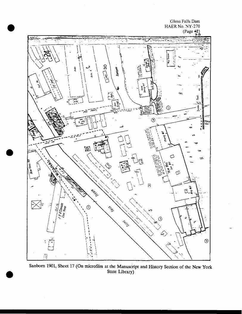
Glens Falls Dam HAER No. NY-270
<Page«£
•
Sanbom 1901, Sheet 17 (On microfilm at the Manuscript and History Section of the New York State Library)
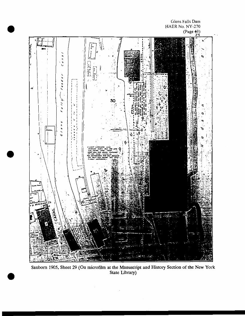
Glens Falls Dam HAER No. NY-270
(Page 43) 31
Sanborn 1905, Sheet 29 (On microfilm at the Manuscript and History Section of the New York State Library)
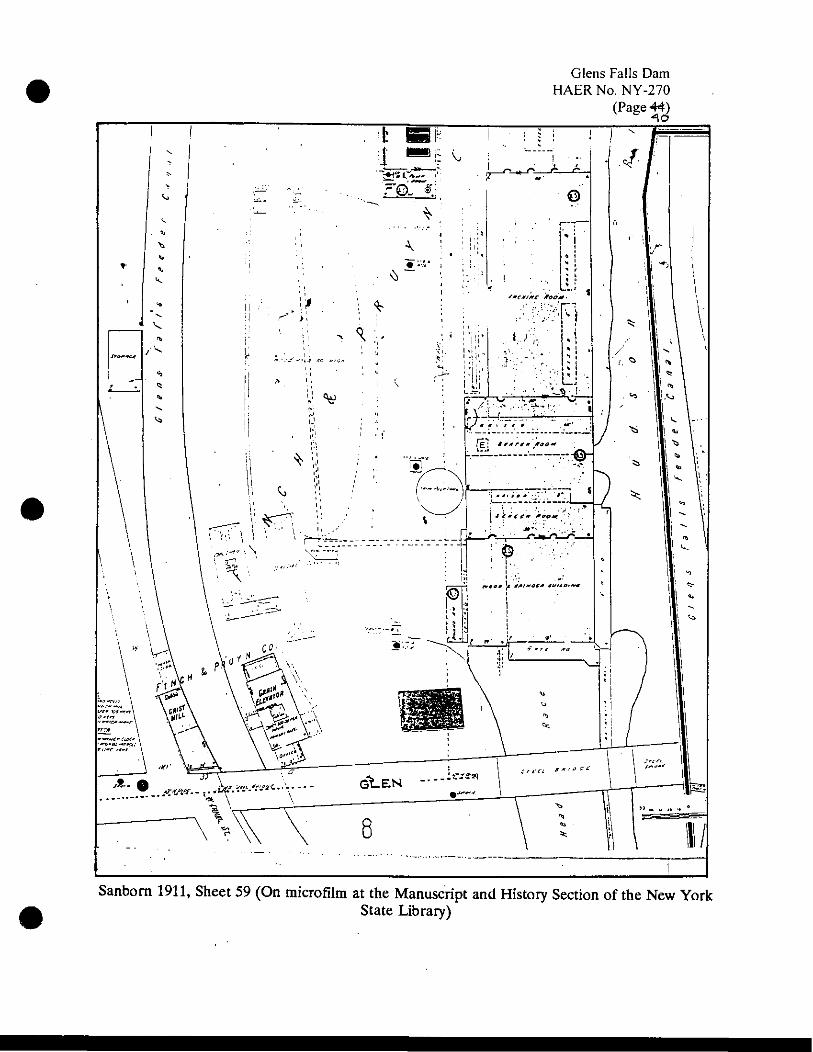
Glens Falls Dam HAERNo.NY-270
(Page**)
Sanborn 1911, Sheet 59 (On microfilm at the Manuscript and History Section of the New York State Library)

Glens Falls Dam HAERNo.NY-270 (Page 4ft)
*«r-f >. . \
s^m^
As m .. * - «ill Hrt
1ft to
^■r ~rr
N^VM
The next eight maps represent development on the south side of the Hudson River. Sanbom 1884, Sheet 7 (On microfilm at Manuscript and History Section of the New York State Library)

Glens Falls Dam HAERNo.NY-270
(Page«jft
Sanbora 1890, Sheet 8 (On microfilm at Manuscript and History Section of the New York State Library)

Glens Falls Dam HAERNo.NY-270
(Page**;
•
Sanbom 1895, Sheet 21 (On microfilm at Manuscript and History Section of the New York State Library)
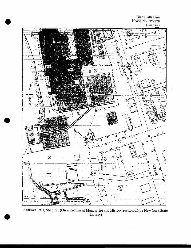
Glens Falls Dam HAERNo. NY-270
(Page 4%)
Sanborn 1901, Sheet 21 (On microfilm at Manuscript and History Section of the New York State Library)

Glens Fails Dam HAERNo.NY-270
(Page 50) ZI5
-col ; ""JZVvy
Sanborn 1905, Sheet 35 (On microfilm at Manuscript and History Section of the New York State Library)

•
Glens Falls Dam HAERNo.NY-270
(Page 54)
Sanborn 1911, Sheet 65 (On microfilm at Manuscript and History Section of the New York State Library)

Glens Falls Dam HAERNo.NY-270
(Page 52)
Sanborn 1911/63, Sheet 65 (On microfilm at Manuscript and History Section of the New York State Library)

Glens Falls Dam HAERNo.NY-270
(Page 5*]
Sanbora 1911/81, Sheet 74 (On microfilm at Manuscript and History Section of the New York State Library)

Glens Falls Dam HAERNo.NY-270
(Page 54)^
Bird's-eye View of Glens Falls (Burleigh 1884; Glens Falls Historical Association, Glens Falls)

Glens Falls Dam HAERNo.NY-270
(Page 5*) 5o
Cooper's Cave in the late nineteenth century (Crandall Library, Glens Falls, New York)