Gladstone Region Industrial Land Strategy Gladston… · in relation to that person or entity...
101
20090639_015_GRILS Final Report.docx Gladstone Region Industrial Land Strategy Final Report – Update July 2012 Gladstone Regional Council July 2012
Transcript of Gladstone Region Industrial Land Strategy Gladston… · in relation to that person or entity...
20090639_015_GRILS Final Report.docx
Gladstone Region Industrial Land Strategy Final Report – Update July 2012 Gladstone Regional Council July 2012

20090639_015_GRILS Final Report.docx
This report has been prepared on behalf of Gladstone Regional Council. SGS Economics and Planning and its associated consultants are not liable to any person or entity for any damage or loss that has occurred, or may occur, in relation to that person or entity taking or not taking action in respect of any representation, statement, opinion or advice referred to herein. SGS Economics and Planning Pty Ltd ACN 007 437 729 www.sgsep.com.au Offices in Brisbane, Canberra, Hobart, Melbourne, Sydney

Gladstone Region Industrial Land Strategy
TABLE OF CONTENTS
EXECUTIVE SUMMARY I Overview i Study Method ii Key Findings iii Recommendations vi
1 INTRODUCTION 1 1.1 Background 1 1.2 Purpose 1 1.3 Study Area 3 1.4 Study Method 4 1.5 A Consultative Approach 4
2 CONTEXTUAL ANALYSIS 5 2.1 Economic Context 5 2.2 Policy Framework 5 2.3 The Governance Framework 8
3 THE SUPPLY OF INDUSTRIAL LAND 9 3.1 Types of Industrial Land 9 3.2 Industrial Land Product 11
Industrial Development Approvals 11 Lot Sizes 13
3.3 Industrial Land Values 13 3.4 Factors Affecting Supply 15
Infrastructure 15 Location 15 Site constraints 15 Land Assembly Issues 15 Land Ownership 15 Withholding Issues 15 Efficient Use of Land 15 Highest and Best Use 15 Urban Encroachment 16 End User Requirements 16
3.5 Gladstone Region Industrial Sectors and Precincts 16 3.6 Gladstone Region Industrial Land Supply 18
4 INDUSTRIAL LAND DEMAND 20 4.1 Historical Consumption Rates 20 4.2 Factors Affecting Industrial Land Demand 20
Population and Settlement 20 Economic Cycles 21 Labour Force Participation 21

Gladstone Region Industrial Land Strategy
Industry Requirements 21 Supporting Industry 21 Key Infrastructure 22
4.3 Industrial Land Forecast 22 4.4 Distribution of Forecast Industrial Land Demand 28 4.5 Forecast Industrial Land Demand Adjustments 28 4.6 Perceived Industrial Market Needs 28 4.7 Meeting Industry Needs through the Planning and Development Framework 29
Planning Regulation and Governance Issues 29 Site Design 30
5 THE GLADSTONE REGION INDUSTRIAL LAND STRATEGY 31 5.1 Extensions to Existing Industrial Precincts 33
Hanson Road Extension Area 33 Barney Point Extension Area 35 Toolooa Extension Area 36 Calliope Extension Area 37 Boyne Island – Tannum Sands Extension Area 38
5.2 New Industrial Land 40 Red Rover Road Investigation Area 40 Tannum Sands Investigation Area 42 Agnes Water Bicentennial Drive Investigation Area 43
5.3 Noxious and Hazardous Industry and High Impact Industry Co-location Opportunities 44 QAL Alumina Refinery 45 Boyne Smelters Limited, Aluminium Smelter 47 Gladstone Power Station 48
6 INDUSTRIAL PLANNING AND DEVELOPMENT FRAMEWORK 49 6.1 Implementation 49 6.2 State Planning Instruments 50
Queensland Planning Provisions 50 6.3 Local Planning Instruments 50
Strategic Framework 50 Zones 54 Precincts of Zones 58 Level of Assessment 59 Industry Codes 61 Industry Activity Code 62
7 APPENDICES 69 7.1 Appendix A – Consultation List 69 7.2 Appendix B – Industrial Zoned Land Supply Analysis 72 7.3 Appendix C – Consultation Findings 84

Gladstone Region Industrial Land Strategy i
EXECUTIVE SUMMARY
Overview
Significant structural reform of Queensland’s planning and development framework, recent local government reform, and the continued economic uncertainty caused by the 2008 global financial crisis, have culminated to provide an array of complex and varying requirements and considerations for the provision of industrial land within the Gladstone Region. The Gladstone Region is synonymous with industrial activity. Industry employs approximately 37% of the work force, accounting for approximately 9,400 people. With such a large proportion of the labour force supported by the industry sector, the need for the protection and continual availability of industrial land is emphasised. The emerging Liquefied Natural Gas (LNG) industry provides a significant opportunity for the Gladstone Region, with seven LNG plants proposed in the Gladstone State Development Area (GSDA). Three LNG plants are currently under construction and these alone are expected to generate 18,000 jobs in Queensland and increase gross state product by over $3 billion. It is likely the LNG industry will generate its own industrial chain requirements, with potential facilities being located within the Gladstone Region. An adequate supply of urban land across the broad land use categories is important for social, economic and environmental reasons. By determining the amount and location of land available for different land uses, planning policies can influence the location, size, and scale of business activities, and, in turn, the type and cost of land and properties. Industrial land values can adjust in response to demand and supply. If considered in isolation, the trend in price of land will reflect the underlying changes in the demand for and supply of land. If land is in short supply relative to demand, competition among consumers will bid up the market price. As the price rises, suppliers will seek to develop more land, or to utilise the existing supply to offer more blocks of the type that consumers are seeking. The rise in price also means that the cost will exceed the affordability of some potential purchasers, dampening demand growth. The Gladstone Region Industrial Land Strategy focuses on the adequacy of long term supply with respect to underlying demand. Underlying demand is estimated based on the expected ratio of land required relative to population, employment, industrial activity, and other factors that affect land use. Unless the supply side constraints of a property shortfall are addressed, including consideration of the appropriateness of supply relative to demand, there will be implications for the availability and affordability of industrial land. A shortage in the supply of land for industrial uses, is likely to increase prices of existing industrial land, thereby raising the cost (including opportunity costs) of doing business in the Gladstone Region. Issues of affordability can affect both the level and range of business activities in a region. An increase in business costs impacts the viability of both incumbent firms and new entrants to the market. Moreover, a limited supply can restrict choices for existing businesses to expand within an existing market, or importantly for the LNG and energy sectors, move into new and emerging markets. The requirement to prepare a new Planning Scheme for the Gladstone Region provides an opportunity to facilitate and improve the strategic planning of industrial land within the GRC area and appropriately cater for the projected industrial land demand. Specifically, the aims of the Industrial Land Strategy are to:
Broadly identify the existing supply and future demand for industrial land in the Gladstone region taking into consideration the economic opportunities and competitive advantages for the development of a broad range of industrial activities that will influence the development of the study area within the short (5-10 years), medium (10-15 years) and long-term (15+ years);

Gladstone Region Industrial Land Strategy ii
Identify land which may be suitable for industrial development and inform the Council of the relevant characteristics and constraints including the required infrastructure, affecting the future ecologically sustainable development of these areas and the industrial uses that could be appropriately established;
Prepare the design and siting guidelines and other planning tools for existing and any new industrial areas; and
Establish a suitable monitoring program to ensure that industrial land supply meets actual demand. As part of Gladstone Regional Council’s requirement to prepare a new Planning Scheme compliant with the Sustainable Planning Act 2009 (SPA), Gladstone Regional Council (GRC) commissioned SGS Economics and Planning Pty Ltd to prepare an Industrial Land Strategy (ILS) for the purpose of providing input regarding the likely future need for, and location of, additional industrial land within the Gladstone Region for the next 20 years and beyond.
Study Method
The ILS was developed over a 9 month period and is the culmination of the three study stages outlined below. An extensive amount of research was undertaken in Stage 1 to develop an understanding of the Gladstone Region context, current industrial market conditions and the planning and development framework affecting the supply and demand for industrial land. A number of site visits were conducted and the Region’s industrial land supply was mapped and quantified. Stage 2 focussed on industrial land demand and analysed global trends, economic activity and the socio demographic profile of the Gladstone Region. Market trends relating to the provision and operation of industrial land were identified and historical consumption rates were established. A demand forecast model was established to estimate the demand for industrial land in the short, medium and long term. Stage 3 reconciled data produced in Stage 1 and 2 and assessed the quality of the existing industrial land stock and its ability to meet market needs. A gap analysis of industrial land supply and demand was undertaken to ascertain the shortfall or surplus of industrial land. Future industry areas were identified to cater for future demand and prioritised against key market criteria. Implementation mechanisms were identified to inform the preparation of a new Gladstone Region Planning Scheme. Prior to acceptance of the Final ILS, Gladstone Regional Council commissioned a further work to extend the scope of the ILS to include consideration of the supply and demand for research and technology industry uses. In July 2012 the ILS was updated to include current population projections provided by the Office of Economic and Statistical Research. The study process is illustrated in Figure 2 below.
FIG URE 1. GLAD STO NE REGIO N I ND U STRI AL L AND STR ATEGY ST UDY ME THO D
Source: SGS Economics and Planning, 2012
Stage 1: Gladstone Region Industrial Development Context and Industrial Land Supply Analysis
Stage 2: Gladstone Region Industrial Land Demand Analysis
Stage 3: Gladstone Region Industrial Land Development Investment Opportunity Identification
Addendum 1: Update to include consideration of Research and Technology Industry
Addendum 2: Update to reflect amended OESR 2011 population projections

Gladstone Region Industrial Land Strategy iii
Key Findings
The design and locational requirements for industry sectors differ based on end user needs. However, the planning for further industrial land should consider:
The more efficient use and extension of existing industrial sites and precincts, particularly those with high locational values;
An appropriate balance of smaller lots to cater for small to medium enterprise and larger lots to cater for larger industry types;
Facilitation of a streamlined regulatory environment that provides regulation for a purpose, minimises regulation where possible, and encourages robust and well made development applications;
The relationship between industrial land, employment, population and the need for industry services in appropriate locations.
Analysis of the above figures indicate that the development and release of industrial land within Gladstone City has slowed in recent years, possibly due to the impact of the Global Financial Crisis (GFC), and development activity, in the form of development approvals, broadly correspond with industrial land release. It is possible that the relationship between industrial development approvals and land release stems from the under supply of industrial land and the demand of the market to develop such land as it becomes available. Alternatively, development approvals and industrial land release in Gladstone City simply correspond with economic cycles, as evidenced by the impact of the GFC and reduced industrial development activity. Trends over the past 5 years show a strong demand for lots 5,000m² and below, and consultation findings suggest that lots between 2,000m² and 5,000m² and above 1 ha are in greatest demand. Consistent with analysis of existing industrial precincts, consultation findings also indicated that suitable lots above 1 ha were scarce due to past development practices to subdivide larger lots in an attempt to maximise development returns or make lot parcels more affordable. While the Gladstone Region business environment is dominated by small to medium enterprise (SMEs), whose end user requirements are consistent with demand trends, a mix of lot sizes is considered essential for the long term sustainability of industrial land provision to ensure all industry sectors are catered for. A recent trend is also the construction of industrial units. Historically this style of property has struggled in regional markets such as Gladstone, however they do provide an affordable alternative to larger holdings and allow clustering of service activities for small business. In general however owner occupiers from the service industry sector appear to desire land holdings, perhaps based on the requirement to utilise additional land areas attached to workshop/warehouse scenario or the perceived benefits of capital growth within the land component over time. Whatever the reason, it appears private sector development of industrial land has been largely catered for by entrepreneurial developers somewhat misaligned with market needs or seeking to maximise return. This is evidenced by the involvement of industrial land provision by the Department of Local Government and Planning’s (DLGP) Property Services Group, and, to a lesser extent, development of industrial land by the Gladstone Ports Corporation (GPC). State government facilitation of industrial land occurs where there is perceived market or planning failure, supporting the postulation that the private sector has sought short term gain over addressing market needs. Factors affecting the supply of appropriate industrial land include:
Infrastructure availability
Location relative to end user markets and needs
Site constraints restricting development of land
Land assembly issues
Land ownership
Withholding issues
Efficient use of land
Highest and best use of land
Urban encroachment

Gladstone Region Industrial Land Strategy iv
End user requirements Twelve existing industrial precincts exist in with the Gladstone Region, including:
Barney Point Industry Area
Blain Drive Industrial Area
Callemondah Industrial Estate
Clinton Industrial Estate
Hanson Road Mixed Business and Industry Area
South Trees Industrial Area
Toolooa Industrial Area
Boyne Island-Tannum Sands Industrial Area
Calliope Industrial Area
Agnes Water General Industry
Agnes Water Light Industry
Miriam Vale Currently there is approximately 505.7 hectares of total industrial zoned land within the identified industrial precincts of the Gladstone Region. Of this, approximately 171.9 hectares is developed for industrial purposes and 13.7 hectares is developed for other purposes. Of the remaining 320.1 hectares of vacant industrial zoned land, 95.3 ha is serviced, or has the potential to be serviced with reticulated infrastructure through the priority infrastructure plan, and is considered net industrial land supply. The remaining 220.7 hectares of unserviced industrial zoned land, is considered raw industrial land and would equate to 110.35 hectares of net land supply. Taking into account existing development approvals and industrially appropriate strategic port land, approximately 33.7 ha of additional development ready net industrial land is available to the industry sector in the short-term, or within the next 10 years providing the planning regulation appropriately supports such development. Relative to population, settlement patterns and access to markets, the Miriam Vale sector has a disproportionate supply of industrial zoned land compared with other sectors. Much of this land is unserviced, and in most cases does not have the ability to be serviced in the medium to long-term. Inappropriately zoned land distorts industrial land supply estimates and is particularly the case for Agnes Water and a significant proportion of vacant land within the South Trees precinct.
TABLE 1 . GLAD STO NE REGIO N I ND U STRI AL L AND SUPPLY
Planning Sector Short Term Supply
2011-2020
Medium Term Supply
2021-2025
Long Term Supply
2025 - 2031
Gladstone City 85.9 ha 0 ha 0 ha
Calliope 9.5 ha 8.7 ha 0 ha
Miriam Vale 5.9 ha 2.4 ha 0 ha
Gladstone Region Total 101.3 ha 10.1 ha 0 ha
Source: SGS Economics and Planning, 2010
A total of 111.4ha of existing and approved net industrial land is considered available in the Gladstone Region to 2031. Population growth can be relied upon as an indicator for growth within the region, however does not simplistically translate to predicting future industrial land demand, as it does for residential land types. The key demand drivers identified for Gladstone Region industrial land include:
Population and settlement patterns
Economic cycles
Labour force participation
Industry requirements
Supporting industry
Key infrastructure

Gladstone Region Industrial Land Strategy v
2011 OESR population projections for the Gladstone Region estimate the current population of about 63,000 people will grow to approximately 111,670 by 2031. This has been revised upwards from the 2008 estimates provided utilised in the original ILS demand projections and suggests approximately 13,000 more people will reside in the region by 2031.
TABLE 2 . TOTAL GL AD STO NE R EGI O N INDU STR IAL LAND D E MAND, 2 011 MED IU M S ERIES FORECAST BY STANDARD I ND U STRY ZONE
QPP Standard Industry Zone Land Area Change (ha) 2006-2031
Noxious and Hazardous Industry 126.21
High Impact Industry 34.03
Medium Impact Industry 19.76
Low Impact Industry 117.65
Waterfront and Marine Industry 100.71
High Technology Industry 4.19 Community Purposes (Utility Installations excl network infrastructure) 16.21
Total 418.77 Source: SGS Economics and Planning, 2012
Industry sectors identified as being more appropriately located on land outside the jurisdiction of Council, or provided by other government agencies, and excluded from the ILS include:
High impact industry such as ‘beverages and tobacco products’ and ‘rubber and plastic products’;
Noxious and hazardous industry such as ‘petroleum and coal products’, ‘basic metals and products’ and ‘chemicals manufacturing’;
Waterfront and marine industry such as ‘water transport’ and port related facilities; and
Government controlled transport related industry such as passenger rail and airport services and associated infrastructure.
Extractive industry due to site specific development requirements.
TABLE 3 . REVISED I ND U STRY LAN D D EMAND BY QPP ZONE TYPE
QPP Standard Industry Zone Site Area Change (ha) 2006-2031
Noxious and Hazardous Industry 0.30
High Impact Industry 34.03
Medium Impact Industry 15.01
Low Impact Industry 119.17
High Technology Industry 2.26
Community Purposes (Utility Installation excl network infrastructure) 11.72
Total 182.49 Source: SGS Economics and Planning, 2012
distribution and concentration of land demand varies across the region based on economic activity, population growth, urban settlements and end user needs. Table 12 provides a general benchmark as to the distribution of industrial land demand across the Gladstone Region based on estimated employment change by planning sector and average employee to land area ratios.
TABLE 4 . REVISED NET I NDU STRI AL LAND DEM AND FOR EC AST BY PLANNING SECTOR TO 2031
Planning Sector Site Area (sqm) Net Site Area (ha)
Gladstone & Calliope 1,677,384 167.74
Miriam Vale 147,488 14.75 Source: SGS Economics and Planning, 2012

Gladstone Region Industrial Land Strategy vi
Recommendations
Based on a forecast demand of 182ha of net industrial land out to 2031, it is recommended a minimum of 320ha raw land should be identified as industry investigation areas to allow a rolling stock of industrial land to be under investigation and ensure a perpetual 20 year supply of industrial land is planned for and available when required. Extensions to existing industrial precincts refer to land adjoining existing industry activities that has the potential to be developed for industrial purposes. These areas generally represent opportunities for the short to medium term provision of industrial land. Potential extension areas have been identified at:
Hanson Road Precinct
Barney Point Precinct
Toolooa Precinct
Calliope Precinct
Boyne Tannum Precinct Extensions to industrial precincts represent 94 ha of new industrial land for the Gladstone Region which is broadly suitable for mixed use, low impact and limited medium impact industry. Given the largely developed nature of these areas, they are considered to represent approximately 65ha of net industrial land. The ILS has identified 8 potential industrial areas that are subject to further investigation. Of these 3 were considered priority sites, when analysed against established assessment criteria, that could potentially be available in the short to medium term. The 8 new industrial areas include:
Red Rover Road
Calliope River Mouth
Calliope North
Calliope East
Boyne Tannum North
Boyne Tannum South
Tannum Sands STP
Agnes Water Bicentennial Drive The following sites were considered priority sites:
Red Rover Road
Tannum Sands STP
Agnes Water Bicentennial Drive.
Priority sites represent approximately 230 ha of raw, or 115 ha of net industrial land for the Gladstone Region which, subject to further investigation may be suitable for mixed use, low impact and medium impact industry. Combined extension and new industrial areas indentified above represent approximately 180ha of net industrial land area. The availability, quality and delivery of industrial land crosses a number of plans, strategies and jurisdictions within the Gladstone Region. Implementation of the ILS will rely on existing planning mechanisms within the planning and development framework, as well as ensuring its principles are incorporated into future planning strategies. The ILS is intended to be dynamic in that it can be reviewed and amended in response to economic activity such as major projects, population forecasts or changes to legislation or regulation. The ILS is intended to be a non-statutory document, however elements are to be given statutory weight through alignment of the Gladstone Region Planning Scheme. On this basis, a necessary component to the effective implementation of the ILS is the continual monitoring of economic activity and take up of industrial land. Monitoring will ensure an appropriate stock of industrial land is available relative to industry demand through the timely release of industrial land identified within the ILS. It is recommended that precincts are utilised to achieve specific industrial outcomes for a number of localities such as:
preserving an appropriate mix of lot sizes within a given area to ensure a variety industry sectors are catered for;
supporting or discouraging particular industry types within a precinct;
minimising planning regulation for supported industry types within appropriate precincts; and

Gladstone Region Industrial Land Strategy vii
protect industrial areas from incompatible development. It is recommended the ILS be used as a guide in developing suitable precinct planning outcomes where appropriate. General topics suitable for inclusion in the Industry Zone Codes include:
Protection of industrial areas
Buffer requirements
Interface treatments
Lot size and mix
Built form
Density
Visual amenity
Emissions including noise, air pollutants, light, waste and stormwater
Stormwater management
Security
Public Safety
Vehicular Access and Car Parking
Energy efficiency
Sustainability
Structure planning

Gladstone Region Industrial Land Strategy 1
1 INTRODUCTION
1.1 Background
Significant structural reform of Queensland’s planning and development framework, recent local government reform, and the continued economic uncertainty caused by the 2008 global financial crisis, have culminated to provide an array of complex and varying requirements and considerations for the provision of industrial land within the Gladstone Region. This Industrial Land Strategy is Gladstone Regional Council’s response to the future of industrial land provision within the Gladstone Region. The Gladstone Regional Council (GRC) was created in March 2008 by the amalgamation of the former Gladstone City Council, Calliope Shire Council and Miriam Vale Shire Council. It lies some 514km north of Brisbane and its economy is based largely on industry attracted by its natural deepwater harbour and proximity to primary resources. The GRC area currently has a resident population of approximately 59,000 mostly within its major urban centres of Gladstone, Calliope, Boyne Island, Tannum Sands and Agnes Water. The remainder of the population is dispersed in a number of smaller villages, rural residential communities and the broader rural area. The population is predicted to grow by about 2.95% per annum through to 2031 when it could have a population of about 111,000.
In 1993 an area of approximately 6,800 hectares of land north-west of Gladstone was identified as being broadly suitable for major industrial development and was purchased by the State and declared a State Development Area (the GSDA). The GSDA has been amended several times and now comprises approximately 28,000 hectares, the most recent extension being onto Curtis Island. A number of Liquefied Natural Gas (LNG) plants are proposed to establish operations in the GSDA. These may also generate their own industrial chain requirements, with potential facilities being located within the Gladstone Region. Although the GSDA has been established to provide for major industrial development of regional, state and national significance, there is purported to be a lack of future industrial land supply within the remaining GRC area to provide for the growth of general and service industry to cater for the needs of the growing population of the Gladstone region, and potentially the LNG sector. By nature, population servicing industry needs to be located in proximity to the catchments being serviced, whereas large scale industrial development such as intended within the GSDA requires significant separation from sensitive uses due to potential environmental impacts.
The Industrial Land Strategy (ILS) and the provision of future industrial land for the Gladstone Region, considers the relationships between population and jobs, and the relationship between population and the need for industry services.
1.2 Purpose
The requirement to prepare a new Planning Scheme for the Gladstone Region provides an opportunity to facilitate and improve the strategic planning of industrial land within the GRC area and appropriately cater for the projected industrial land demand. Specifically, the aims of the Industrial Land Strategy are to:

Gladstone Region Industrial Land Strategy 2
Broadly identify the existing supply and future demand for industrial land in the Gladstone region taking into consideration the economic opportunities and competitive advantages for the development of a broad range of industrial activities that will influence the development of the study area within the short (5-10 years), medium (10-15 years) and long-term (15+ years);
Identify land which may be suitable for industrial development and inform the Council of the relevant characteristics and constraints including the required infrastructure, affecting the future ecologically sustainable development of these areas and the industrial uses that could be appropriately established;
Prepare the design and siting guidelines and other planning tools for existing and any new industrial areas; and
Establish a suitable monitoring program to ensure that industrial land supply meets actual demand. As part of Gladstone Regional Council’s requirement to prepare a new Planning Scheme compliant with the Sustainable Planning Act 2009 (SPA), Gladstone Regional Council (GRC) commissioned SGS Economics and Planning Pty Ltd to prepare an Industrial Land Strategy (ILS) for the purpose of providing input regarding the likely future need for, and location of, additional industrial land within the Gladstone Region for the next 20 years and beyond. This ILS focuses on low and medium impact industry, service industry, research and technology industry and warehousing needs as defined by the Queensland Planning Provision version 2 (QPP), but also considers the needs of high impact industry, noxious and hazardous industry, and waterfront and marine industry. High impact and noxious and hazardous industries represent the most intensive type of industrial development. These industries are likely to require significant infrastructure and land resources such as increased requirements for land area, buffer areas, power, water, gas, roads, rail and port access. Due to these specific requirements, the Gladstone State Development Area has been identified as more appropriate to locate these types of uses and therefore a specific land demand forecast for high impact industry and noxious and hazardous industry has been refined to include those types of industry likely to be located outside the GSDA. High impact and noxious and hazardous industries currently exist within the Gladstone Region Local Government Area (LGA). It is also recognised that not all high impact and noxious and hazardous industries may be suitable for location within the GSDA. Therefore, it is recommended that locations for high impact and noxious and hazardous industries are considered at the precinct design stage for industry investigation areas or a located in proximity to existing high impact or hazardous and noxious industries where appropriate. Furthermore, a majority of land with access to the waterfront within the Gladstone metropolitan area is under the jurisdiction of the Gladstone Ports Corporation as Strategic Port Land. Thus waterfront and marine industry requiring direct waterfront location has been identified as being more appropriately located within Strategic Port Land and is also not included in this ILS. Other definitions within the QPP that can be broadly categorised as industrial activities include extractive industry, and some utility installations, excluding low impact network infrastructure. Extractive industry has not been considered as part of this ILS given its specific land requirements, particularly the presence of extractive material. Utility installations, excluding their associated network infrastructure, have been considered under the ILS including an estimated land demand. For the purposes of this study it is recommended utility installations be considered synonymous with the medium impact industry based on their likely impact and compatibility with such uses. The QPP also provides for mixed use zones which cater for service industry and low-impact industrial uses among other commercial and residential uses. Consideration as to the appropriateness and effectiveness of a mixed use zone in preserving industrial land for industrial purposes has been considered within this ILS. While a mixed industry zone may be appropriate in some circumstances, particularly within the Hanson Road Precinct, it may prove difficult to regulate in terms of industrial land preservation due to encroachment of non-industrial uses. The ILS is the final stage of a three stage study process which, to date, has identified, documented and analysed the Gladstone Region context, industrial development, and supply and demand of industrial land. The aim of the ILS is to provide a high level strategic framework for the supply and management of industrial land that will ensure the ongoing economic growth of the Gladstone Region.
Gladstone Region Industrial Land Strategy 3
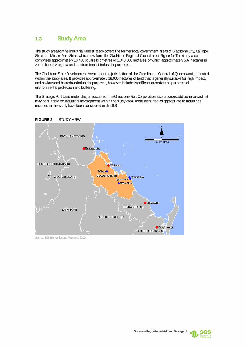
1.3 Study Area
The study area for the industrial land strategy covers the former local government areas of Gladstone City, Calliope Shire and Miriam Vale Shire, which now form the Gladstone Regional Council area (Figure 1). The study area comprises approximately 10,488 square kilometres or 1,048,800 hectares, of which approximately 507 hectares is zoned for service, low and medium impact industrial purposes. The Gladstone State Development Area under the jurisdiction of the Coordinator-General of Queensland, is located within the study area. It provides approximately 28,000 hectares of land that is generally suitable for high impact, and noxious and hazardous industrial purposes, however includes significant areas for the purposes of environmental protection and buffering. The Strategic Port Land under the jurisdiction of the Gladstone Port Corporation also provides additional areas that may be suitable for industrial development within the study area. Areas identified as appropriate to industries included in this study have been considered in this ILS.
FIG URE 2. ST UDY AREA
Source: SGS Economics and Planning, 2010

Gladstone Region Industrial Land Strategy 4
1.4 Study Method
In order to address the aims of the ILS, the study was undertaken over three stages, as illustrated in Figure 2 below.
FIG URE 3. GLAD STO NE REGIO N I ND U STRI AL L AND STR ATEGY ST UDY METHO D
Source: SGS Economics and Planning, 2010
The ILS was developed over a 9 month period and is the culmination of the three study stages outlined above. An extensive amount of research was undertaken in Stage 1 to develop an understanding of the Gladstone Region context, current industrial market conditions and the planning and development framework affecting the supply and demand for industrial land. A number of site visits were conducted and the Region’s industrial land supply was mapped and quantified. Stage 2 focussed on industrial land demand and analysed global trends, economic activity and the socio demographic profile of the Gladstone Region. Market trends relating to the provision and operation of industrial land were identified and historical consumption rates were established. A demand forecast model was established to estimate the demand for industrial land in the short, medium and long term. Stage 3 reconciled data produced in Stage 1 and 2 and assessed the quality of the existing industrial land stock and its ability to meet market needs. A gap analysis of industrial land supply and demand was undertaken to ascertain the shortfall or surplus of industrial land. Future industry areas were identified to cater for future demand and prioritised against key market criteria. Implementation mechanisms were identified to inform the preparation of a new Gladstone Region Planning Scheme.
1.5 A Consultative Approach
Targeted consultation was undertaken during preparation of the ILS with key government and industry representatives and industrial land stakeholders. Information garnered from the consultation process offered guidance with respect to the commercial realities of providing industrial land, perceived needs of government and industry, and a realistic perspective of what is occurring within the industrial property market in Gladstone. Consultation findings provided valuable information regarding the assumptions made with regard to developing an industrial land demand forecast and challenges and issues that exist with the provision of industrial land currently. Consultation findings contributed to the formation of the ILS; in particular items contained in sections 3.1, 4.3, 4.4, 5.2 and 5.4 of this report. Appendix A contains a complete list of stakeholders consulted throughout the course of the study.
Stage 1: Gladstone Region Industrial Development Context and Industrial Land Supply Analysis
Stage 2: Gladstone Region Industrial Land Demand Analysis
Stage 3: Gladstone Region Industrial Land Development Investment Opportunity Identification

Gladstone Region Industrial Land Strategy 5
2 CONTEXTUAL ANALYSIS The supply and demand of industrial land and associated needs of industry and industrial development are influenced by global, national, state and local economic trends and associated policies, strategies and legislation. The preparation of the ILS has considered the economic context and commercial reality of industrial land use planning in detail, including the current planning framework and governance arrangements in the Gladstone Region, and trends in the need, demand and supply of industrial land.
2.1 Economic Context
The recent economic history of the Gladstone Region is synonymous with boom and bust cycles that rest on the back of the resources industry and associated projects. Development and investment has risen and fallen with construction projects, such as the QAL refinery in the late 1960s, the Boyne smelter in the early 1980s, Orica, renovations to the power station, continued port extension, Cement Australia, and recently Rio Tinto Yarwun. Traditionally the Gladstone Region, particularly northern metropolitan areas, has been linked since the 1960s with aluminium. Bauxite from Weipa in North Queensland is refined into alumina at the largest alumina refinery in the world, the Queensland Alumina Limited (QAL) plant. Alumina is converted into aluminium at Boyne Smelters Limited (BSL), requiring about half the energy generated by the power station. Gladstone is also the site of Queensland's fledgling $40 billion liquefied natural gas industry, which the state government expects will generate 18,000 jobs across a region of 55,000 people. However, recent concern over the environmental impacts of coal seam gas extraction, has led to an uncertainty about whether the short to medium term growth of the Region would actually occur at the rate anticipated. Optimism and business confidence is returning however buoyed by strong demand from China for mineral and energy commodities with forecasts indicating strong short term growth driven by higher export prices and volumes for most commodities. It remains to be seen if this will translate to development commitment and speculative interest in the Gladstone industrial land market.
2.2 Policy Framework
Significant reform to both local government and the land use planning and development framework in Queensland has occurred in recent years culminating in the amalgamation of local government areas throughout the State and the introduction of the Sustainable Planning Act 2009 and the Local Government Act 2009. The Gladstone Region faces significant challenges as a result of the reforms, and given their currency, it is necessary to explore the new legislation and policy requirements, existing policies, plans and strategies and any transitional arrangements in detail in order to understand their impacts on the Gladstone Region in terms of industrial land supply, demand and governance. A summary of the legislation, policy, strategies and plans that form the planning and development framework for the Gladstone Region are summarised in the table below.

Gladstone Region Industrial Land Strategy 6
TABLE 1 . GLAD STO NE REGIO N PL A NNI NG AND DEVELO PME N T FR AMEWOR K
Planning Document Role and Responsibility
Legislation
Sustainable Planning Act 2009 Provides the overall planning process required to implement state and local planning instruments, assess development applications, prepare priority infrastructure plans, appeals to the Planning and Environment Court in Queensland and is accompanied by statutory guidelines and definitions.
Local Government Act 2009 Provides a principles-based framework for decision making and governance for Local Governments. In essence it provides the guiding principles, for which Councils should plan, operate and account for the management and delivery of public services. The LG Act aims to give local governments flexibility to decide processes that suit their size, location and administrative circumstances, as long as the processes are rational, justifiable and transparent.
State Development and Public Works Organisation Act 1971
Provides for state planning and development through a coordinated system of public works organisation and for environmental coordination. It provides the person holding the office of the Coordinator-General with significant powers to manage major projects, coordinate environmental impact assessments and direct programs of works on a whole-of-government basis.
Transport Infrastructure Act 1994 Establishes the regime under which Port Authorities operate –within an overall strategic framework for operation of Government owned corporations. It designates Queensland’s Port Authorities as landowners and land managers to have statutory authority over “Strategic Port Land”
State Planning Instruments
Queensland Planning Provisions The QPP provide a consistent structure for planning schemes and standard provisions for implementing integrated planning at the local level. The QPP contains both mandatory and non-mandatory parts. It outlines a mandatory: Structure; Format; Standard use and administrative definitions; Standard zones and codes; Limited prescribed levels of assessment; and Standard overlays.
Regulatory Provisions The Wide Bay Burnett Regulatory Provisions currently in draft format are designed to protect regional planning priorities during the preparation and implementation of a statutory regional plan for the wide bay burnett region. Notably, the former Miriam Vale shire area is excluded from the draft provisions, and will be incorporated into future Central Queensland Regional planning.
State Planning Policies Numerous State Planning Policies (SPPs) exist within Queensland and have a direct affect in the assessment of relevant development applications and indirect affect through the alignment of regional and local planning schemes. Those SPPs not adequately reflected in existing planning schemes within the Gladstone Region will be considered in the preparation of the Strategy. Notably the State Planning Policy – Coastal Protection and State Planning Policy Air, Noise and Hazardous Materials 2009 are in draft format and require consideration.
Port of Gladstone Strategic Plan The 50-year Strategic Plan first appeared in 1992 and was updated in 2008 which indicates that the Port of Gladstone harbour will be able to accommodate up to 300 million tonnes (Mt) per annum of export product within the next 50 years. The main focus of the port’s future growth will be the Western Basin Development, which will have a capacity to move 150 to 200Mt of product annually. GPC has completed a Channel Duplication Study to identify the strategic development of dredged access to the port to cater for long term industrial growth and have conducted the Environmental Impact Statement (EIS) for dredging works. A final decision on the EIS is expected in 2010.
Port of Gladstone Land Use Plan The Port of Gladstone Land Use Plan (LUP) 1999 currently in effect is a time damaged document and represents the first land use plan for the Port. It lacks detailed planning, however adequately identifies the extent of GPC land holding, land title and future intent and any reclamation works.

Gladstone Region Industrial Land Strategy 7
Planning Document Role and Responsibility
A statement of proposals was released for the Port of Gladstone and Port Alma Land Use Plan Review in early 2010. Legislative changes effected since the adoption of the current land use plan add detail and clarify land use planning processes for port authorities, in a similar vein to the preparation of planning schemes. A draft LUP for the Port of Gladstone was released in October 2010. It adds detail and rigor to the 1999 LUP by clearly conveying its application, purpose, legislative context, interpretation and desired overall outcomes. The primary component of the draft LUP is the identification of Port Planning Localities and Land Use Precincts which describe the intent for each and built form, infrastructure, environmental and social outcomes, and consistent uses. The LUP is supported by a non-statutory Gladstone Port Development Code which will provide further detail for development design and assessment on strategic port land. It is noted that the extent of strategic port land identified in the LUP 1999 and draft LUP 2010 differ, particularly with regard to strategic port land in existing urban areas such as Hanson Road.
Gladstone State Development Area
The Gladstone State Development Area comprises some 28,000 hectares and provides land for industrial development of national, State and regional significance and complementary industrial, infrastructure and service uses. A Development Scheme and Precinct Map govern development within the GSDA. The precinct map identifies areas considered broadly suitable for various types of industrial and infrastructure development and identifies a dedicated materials transportation and services corridor and buffer area separating the corridor from land use outside the GSDA. It is noted that the GSDA is to be maintained and protected from incompatible development, including incompatible industrial development. Support and service industries to major projects within the GSDA should be investigated and land use requirements assessed to determine the suitability of the GSDA for support and service industry outside the Gladstone Region Planning Scheme area.
Regional Planning Instruments
The Central Queensland Regional Plan 2002
The Central Queensland Regional Plan gives limited attention to sub regional narratives and gives limited guidance to the Gladstone Region. Since its inception in 2002 many of the specific actions and strategies have been completed or are otherwise outdated. The Plan requires review and amendment to reflect current planning legislation, issues, opportunities and directions. While the broad actions and strategies within the document remain relevant, it has resulted in various plans, strategies, alliances and documents that sit side by side and has resulted in a wealth of guidance information and increased complexity that would benefit from integration and, in some cases, statutory recognition.
The Wide Bay Burnett Regional Plan 2007
Is of little relevance given the former Miriam Vale Shire is now excluded from the draft Wide Bay Burnett State Planning Regulatory Provisions 2010 which have statutory effect until the draft Wide Bay Burnett Regional Plan 2010 is implemented. The former Miriam Vale Shire will be included in Central Queensland regional planning processes to reflect the 2008 local government boundary changes.
The Gladstone Region Integrated Transport Plan 2001-2030
The Gladstone Integrated Regional Transport Plan (GIRTP) was developed to guide the region's transport needs for the future. The plan sets a framework for the future development of the region's transport network up to 2030. The plan aims to meet emerging transport needs for the Gladstone area, in response to regional growth in population, employment and industry. The GIRTP comprises a Vision, Guiding Principles, Key Planning Assumptions and eight action plans. It came into effect in 2002 and is somewhat outdated given the time elapsed since its inception. Consequently the timing of action items are now into the medium and long term scenarios of the GRITP and therefore lacks short term guidance and up to date planning. The GIRTP recognizes Gladstone’s future transport system is tied to the ongoing pattern of Gladstone’s growth as an industrial centre, and that the level and pattern of industrial development and growth is the single most important factor affecting the region’s transport system.
The Central Queensland Strategy for Sustainability – 2004 and
Is the regional plan for the management of the natural resources and environments of the river catchments of the Central Queensland Region.

Gladstone Region Industrial Land Strategy 8
Planning Document Role and Responsibility
Beyond
Local Planning Instruments
Gladstone City Planning Scheme Identifies the strategic and statutory planning framework for the appropriate location and design of industrial activities, including levels of assessment for industrial uses for the former Gladstone City Council area
Calliope Shire Planning Scheme Identifies the strategic and statutory planning framework for the appropriate location and design of industrial activities, including levels of assessment for industrial uses for the former Calliope Shire area.
Miriam Vale Shire Planning Scheme
Identifies the strategic and statutory planning framework for the appropriate location and design of industrial activities, including levels of assessment for industrial uses for the former Miriam Vale Shire area.
Gladstone Region Economic Development Strategy
Provides recommendations and actions that promote, inter alia, the: growth and diversification of the Gladstone Region’s economic base, building on its industrial strength, its established manufacturing and world class port infrastructure to become Australia's premier 21st Century industrial region. continual development of local business and industry from within the region, and across all communities, providing a diversity of sustainable employment and career opportunities for the region's residents.
Source: SGS Economics and Planning, 2010
2.3 The Governance Framework
The unique attributes of the Gladstone Region such as a deep water port, proximity to primary resources, significant infrastructure such as rail, power and water have culminated to produce a somewhat complex governance environment. The diverse needs of State Government, Local Government, industry, transport, and infrastructure provision are managed and supplied under multiple jurisdictions. The GSDA is under the jurisdiction of the Coordinator-General of the Department of Local Government and Planning (DLGP) and comprises its own development scheme and policy directions. Similarly, the Gladstone Port Authority (GPA) controls all strategic port land, land which is identified as important to the ongoing operation and management of the Port of Gladstone and identified as such under the Port of Gladstone Land Use Plan. These lands, outside the control of GRC have direct relationships with the supply and demand for industrial land within the GRC area, and have been considered in the preparation of the ILS.

Gladstone Region Industrial Land Strategy 9
3 THE SUPPLY OF INDUSTRIAL LAND
3.1 Types of Industrial Land
For the purposes of the ILS the supply of industrial land is described through the ability of the land to provide industrial development and the type of industrial development it provides for. The first considers the capacity of industrial land in terms of broad constraints and delivery/availability to the market and has been further defined as:
Vacant unserviced land – requires significant planning and development before it is available to the market for industrial use
Vacant serviced land – land that is development ready and immediately available to the market for industrial use
Developed serviced land – land that is occupied and has been developed for industrial purposes
Developed unserviced land – land that is occupied and developed for industrial purposes however is unsuitable for industry requiring reticulated infrastructure;
Industrial land developed for another purpose – land identified as being suitable for industrial purposes however is occupied and has been developed for other purposes.
The above criterion allows the types of industrial land availability to be quantified within the Gladstone Region and gives an accurate picture of the ability of industrial zoned land to provide development-ready land within a given timeframe. Section 4.5 of this report details the availability of industrial land within the Gladstone Region. Within the general supply of industrial land are areas suitable for specific industrial uses. A range of industrial use zones and definitions have been utilised within the former planning schemes of Gladstone City, Calliope Shire and Miriam Vale Shire. The Queensland Planning Provisions (QPP) provides unanimity between local government planning scheme structure and definitions and provides a suite of standard industrial use zones and definitions to be used in Queensland planning schemes. Level 2 standard zones and their associated purpose and outcomes have been considered as part of this strategy. Existing industrial zones, existing land uses and precinct analysis have been considered to reconcile previous discrepancies between former local government planning schemes and introduce appropriate QPP zones. The ILS therefore anticipates the use of the following QPP zones for industrial activities within the Gladstone Region when drafting of the new planning scheme:
Low impact industry zone
Medium impact industry zone
High impact industry zone
Noxious and hazardous industry zone
Waterfront marine industry zone
High technology industry zone
Industry investigation zone
Mixed use zone
Extractive industry zone Given the high level nature of this ILS the location of specific industry zones have not been identified as part of the ILS. Instead, existing industrial precincts have been identified along with recommendations as to the appropriate allocation of QPP compliant zones from those identified in previous planning schemes. Potentially suitable areas to accommodate industrial land uses are identified for further investigation.

Gladstone Region Industrial Land Strategy 10
Accordingly, this ILS takes a macro-level approach. Those areas considered broadly appropriate to accommodate industrial activities could be zoned industry investigation under the new planning scheme in response to demand in the medium to long term. Micro-level analysis will be required to allocate specific zones or precincts to existing and future industry areas and uses for appropriate zones within the new planning scheme and respond to short term demand. For the purpose of the ILS, the industry use definitions of the QPP to be accommodated through the ILS are provided in Table 2.
TABLE 2 . TYPES O F I NDU STR IAL L A N D U SES
QPP Uses QPP Definition Examples
Medium Impact Industry
Premises used for industrial activities that have moderate impacts on non industrial uses and where impacts such as noise and air emissions are required to be mitigated.
Beverage production, concrete batching plants, tyre manufacturing and retreading, surface coating, metal recovery, junk yard, fuel depot
Low Impact Industry Premises used for low impact industrial activities which have minimal impacts on non industrial uses and where impacts such as noise and air emissions are able to be readily mitigated.
small engine repair workshop, vehicle workshop, cabinet making, shop fitting, sign writing, tyre depot
Service Industry Premises used for industrial activities where manufactured goods are repaired, restored or serviced or commercial services are provided. The uses are not an environmentally relevant activity and any impacts on surrounding uses are contained within the site.
audio visual equipment repair, bicycle repairs, clock and watch repairs, computer repairs, domestic appliance repairs, dry cleaning, hand engraving, film processing, hot bread shop, jewellery making, laundromat, locksmith, picture framing, plan printing, screen printing, shoe repairs, tailor
Research and Technology Industry
Premises used for innovative and emerging technology industries involved in research design, manufacture, assembly, testing, maintenance and storage of machinery, equipment and components. The use may include emerging industries such as energy, aerospace and biotechnology.
Aeronautical engineering, computer component manufacturing, medical laboratories.
Warehouse Premises used for the storage and distribution of goods, whether or not in a building, including self-storage facilities or storage yards. The use may include sale of goods by wholesale where ancillary to the use.
self storage sheds
Outdoor Sales Premises used for the display, sale, hire or lease of products where the use is conducted wholly or predominantly outdoors and may include construction, industrial or farm plant and equipment, vehicles, boats and caravans.
Agricultural machinery sales yard, motor vehicles sales yard
Utility Installation (excluding network infrastructure)
Premises used to provide the public with the following services:
Supply of water, hydraulic power, electricity or gas;
Sewerage or drainage services;
Transport services including road, rail or water;
Waste management facilities
The use includes maintenance and storage depots and other facilities for the operation of the use.
Sewerage treatment plance, mail depot, pumping station.
Source: Queensland Planning Provisions V2.0, 2012
Other industrial land uses identified within the QPP include:
High Impact Industry
Noxious and Hazardous Industry
Waterfront and Marine Industry
Extractive Industry

Gladstone Region Industrial Land Strategy 11
While these industry types have been considered generally to assess their impacts on the industrial land use classifications within the ILS, these uses and their associated land demand have been excluded from the ILS on the basis:
High impact and noxious and hazardous industries that are compatible with the intent of the GSDA Development Scheme should be located within the GSDA where possible, in consultation with GRC and DLGP. It is acknowledged that high impact and noxious and hazardous industry uses currently exist outside the GSDA within the Gladstone Region. These uses should be zoned as such under a new planning scheme to ensure the viability of their ongoing operation and to protect existing land use rights;
Waterfront and marine industry require waterfront land which is generally under the jurisdiction of Gladstone Ports Corporation (GPC) and should be located on strategic port land where possible;
Extractive industry has significantly different locational requirements than other industry uses given it is dependent upon the location of extractive commodities and required to be located at the source of extraction.
In other words, the land requirements and associated land demand for high impact and noxious hazardous industry, waterfront and marine industry, and extractive industry has not been included in land demand forecasts in this ILS. It is noted high impact, noxious and hazardous and waterfront and marine industries exist within the Gladstone Region and some future uses may not be suitable for location within the GSDA or on strategic port land. Accordingly, difficult to locate industries should be considered at the structure planning stage of industry investigation areas and are addressed through local planning instruments at section 6.3 of this ILS. Finally, the QPP defines a utility installation as “Premises used to provide the public with the following services: supply of water, hydraulic power, electricity or gas; sewerage or drainage services; transport services including road, rail or water; waste management facilities; network infrastructure. The use includes maintenance and storage depots and other facilities for the operation of the use”. Under the QPP the Gladstone Power Station would be defined a “utility installation”. Given its proximity to the Gladstone metropolitan area and obviousness to residents, it has been considered appropriate to consider utility installations within this ILS, however network infrastructure has been excluded from assessment on the basis it is more appropriately dealt with under the priority infrastructure plan.
3.2 Industrial Land Product
Industry employs approximately 37% of the work force within the Gladstone Region, accounting for approximately 9,400 people. With such a large proportion of the labour force supported by the industry sector, the need for the protection and continual availability of industrial land is emphasised. The design and locational requirements for industry sectors differ based on end user needs. However, the planning for further industrial land should consider:
The more efficient use and extension of existing industrial sites and precincts, particularly those with high locational values;
An appropriate balance of smaller lots to cater for small to medium enterprise and larger lots to cater for larger industry types;
Facilitation of a streamlined regulatory environment that provides regulation for a purpose, minimises regulation where possible, and encourages robust and well made development applications;
The relationship between industrial land, employment, population and the need for industry services in appropriate locations.
Industrial Development Approvals
The approval of industrial development applications provides a good indicator of industrial land development activity and, to some extent, industrial land consumption trends. While it is noted that development approvals do

Gladstone Region Industrial Land Strategy 12
not necessarily translate to development activity, it provides a good indication of economic activity at the time of approval. This data can be reconciled with ABS non-residential building approvals to ascertain trends in industrial development activity. Figures 3 and 4 show the volume of industrial development approvals and the approximate area of industrial land subdivisions for Gladstone City between the 7
th September 2005 and 7
th September 2010.
FIG URE 4. VOLUME O F INDU ST RI AL D EVELOPMENT APP ROVAL S I N GLAD STO NE CITY 200 5-2010
Source: Gladstone Regional Council with SGS Interpretations, 2010
FIG URE 5. APPROXI M ATE AREA O F I NDU STRI AL L AND P ROD UCE D THRO UGH SUBD IV I SIO N APPROVAL S
Source: Gladstone Regional Council with SGS Interpretations, 2010
1 1
24
19
8 6
0
5
10
15
20
25
30
2005 2006 2007 2008 2009 2010
De
velo
pm
en
t A
pp
rova
ls
Year
Development Approvals
9.5
0
9
4.5
1.5
0
1
2
3
4
5
6
7
8
9
10
2005 2006 2007 2008 2009
He
ctar
es
Year
Area

Gladstone Region Industrial Land Strategy 13
Analysis of the above figures indicate that the development and release of industrial land within Gladstone City has slowed in recent years, possibly due to the impact of the Global Financial Crisis (GFC), and development activity, in the form of development approvals, broadly correspond with industrial land release. It is possible that the relationship between industrial development approvals and land release stems from the under supply of industrial land and the demand of the market to develop such land as it becomes available. Alternatively, development approvals and industrial land release in Gladstone City simply correspond with economic cycles, as evidenced by the impact of the GFC and reduced industrial development activity.
Lot Sizes
Trends over the past 5 years show a strong demand for lots 5,000m² and below, and consultation findings suggest that lots between 2,000m² and 5,000m² and above 1 ha are in greatest demand. Consistent with analysis of existing industrial precincts, consultation findings also indicated that suitable lots above 1 ha were scarce due to past development practices to subdivide larger lots in an attempt to maximise development returns or make lot parcels more affordable. While the Gladstone Region business environment is dominated by small to medium enterprise (SMEs), whose end user requirements are consistent with demand trends, a mix of lot sizes is considered essential for the long term sustainability of industrial land provision to ensure all industry sectors are catered for.
3.3 Industrial Land Values
The Gladstone industrial market has a history of periodic fluctuations corresponding to the boom bust cycles created by the resources sector and speculative investment. It appears historic development practices have attempted to maximise investment returns through the development of smaller lots with an area of around 2,000m². Other development practices have appeared to fragment larger industrial lot holdings in a bid to maximise returns during periods of economic prosperity. A recent trend is also the construction of industrial units. Historically this style of property has struggled in regional markets such as Gladstone, however they do provide an affordable alternative to larger holdings and allow clustering of service activities for small business. In general however owner occupiers from the service industry sector appear to desire land holdings, perhaps based on the requirement to utilise additional land areas attached to workshop/warehouse scenario or the perceived benefits of capital growth within the land component over time. Whatever the reason, it appears private sector development of industrial land has been largely catered for by entrepreneurial developers somewhat misaligned with market needs or seeking to maximise return. This is evidenced by the involvement of industrial land provision by the Department of Local Government and Planning’s (DLGP) Property Services Group, and, to a lesser extent, development of industrial land by the Gladstone Ports Corporation (GPC). State government facilitation of industrial land occurs where there is perceived market or planning failure, supporting the postulation that the private sector has sought short term gain over addressing market needs. DLGP and the GPC have delivered what many property analysts, real estate agents and SMEs believe to be the highest quality industrial developments within the Gladstone Region, namely the Clinton and Hanson Road industrial areas. According to Heron Todd White market commentary on the Gladstone industrial property market for the June quarter of 2010, industrial land has moved upward from being in a state of recovery at the beginning of 2010 to currently at the bottom of the market, with the volume of property sales remaining steady and rental vacancy and rate remaining stable. An over-supply of rental property appears to be available relative to demand. This accords with the advice of several commercial real estate brokers consulted within the Gladstone Region, suggesting activity within the industrial property market is currently slow, although optimistic.

Gladstone Region Industrial Land Strategy 14
Table 3 below shows the industrial land values within the Gladstone Region during 2010 established through consultation with local real estate agents and property valuers.
TABLE 3 . EST IM ATED I NDU STRI AL LAND VALU ES 20 10
Location Un-serviced Vacant Land Serviced Vacant Land Developed Serviced Land Commentary
Gladstone Sector
Clinton Industrial Estate
n/a Start at $230/m² and up to $300/m²
Lease rates start at $125/m² GFA for large industrial sheds >1000m²; No data available for developed sales.
Highly sought after industrial estate, performed well in comparison to other areas through GFC.
Callemondah Industrial Estate
n/a Approx $200 to 220/m² Lease rates start at $125/m² GFA
Significant amount of vacant buildings; performed poorly through GFC
Hanson Road Mixed Business and Industry Precinct
n/a Approx $200 to $250/m² Developed site sales range between $250 to $350/m²; Leases start at approx $135/m²
Highly sought after, premier light industry location, potential sales of up to $350.
Barney Point Light Industry Areas
n/a Approx $150 to $160/m² Average performing area with limited heavy vehicle access. Synergy with Port Central advantage.
Toolooa Industrial Area n/a Approx $150 to $180 Lease rates start at $135; Developed land starts at approx $200/m²
Mixed industry area comprising range of uses; Attractive to industry servicing QAL or population services; Large QAL holdings.
South Trees Industrial Areas
n/a Approx $150 to $160/m² Lease rates start at $135/m² ; Limited data for developed sites.
Wrong side of town, potentially attractive to industry servicing QAL or Boyne Smelters
Calliope Sector
Boyne Island/Tannum Sands Industrial Areas
n/a Limited sales data available.
Calliope Industrial Areas n/a Limited sales data available.
Miriam Vale
Agnes Waters General and Local Industrial Land
$30 - $35 per m2 General Industry
Approx $150 - $180/m² Light Industry (includes on-site services)
Approx $80/m² GFA lease; and $150/m² land
Sales and leasing data is varied, particularly due to amount of industry type uses outside industry zoned areas.
Miriam Vale Industrial Land
n/a n/a n/a Limited data and sales history available.
Source: SGS Economics and Planning, 2010
Analysis of the above 2010 industrial land values indicates land values differ between planning sectors and precincts. Limited data was available for the Calliope Sector based on the recentness of industrial areas and the limited sales data established. The same was true for Miriam Vale due to the limited scale of the industry sector. Generally, however, industrial property values indicate the market preference is for a mix of lot sizes with access to the arterial road network on unconstrained land as evidenced by higher values being placed on land within the Clinton, Callemondah and Hanson Road Precincts. Un-serviced lots were significantly less based on end user needs and the cost of providing reticulated infrastructure.

Gladstone Region Industrial Land Strategy 15
3.4 Factors Affecting Supply
In order to develop an appropriate framework for the delivery of industrial land that meets end user needs, factors affecting industrial land supply need to be understood. A number of factors affect supply that have been identified throughout the study process, and are discussed below.
Infrastructure
Appropriately serviced land has been identified as the primary factor influencing the establishment or relocation of industrial activities. Infrastructure includes an appropriate supply of electricity, water, vehicular access, and telecommunications infrastructure.
Location
The appropriate location of industrial land for end users is synonymous with appropriate infrastructure provision, meaning the appropriate location of industrial land is relative to end user markets and needs. For service industry uses this means location to population and urban settlements, for freight and logistic services access to the arterial road network is paramount, and for industries servicing other markets proximity to those markets is often necessary.
Site constraints
Site constraints may include environmental and conservation areas, wetlands, topography and steep slopes, proximity to sensitive uses, or buffer areas, all of which may restrict the ability of industrial zone land to be developed.
Land Assembly Issues
Land assembly issues include the problems faced by developers or users in attempting to assemble separately owned parcels of land, or where other interests in a property associated with tenure impair the ability to provide conditions suitable for development. For example fragmented land ownership, small lot holdings or withholding landowners may restrict the ability to assemble an appropriate site for industrial development.
Land Ownership
Land ownership can contribute to land assembly problems, however is an issue in its own right in cases where land owners simply do not want to develop industrial zoned land for any number of commercial or personal reasons.
Withholding Issues
Withholding issues include issues related to vacant industrial zoned land held by property owners for the purposes other than industrial development, such as holding for future expansion, buffering to existing industrial activity, or land banking for investment purposes.
Efficient Use of Land
The efficient use of land or better site utilization can result in less land being required to develop industrial activities and effectively increase the area of available supply.
Highest and Best Use
Industrial zoned land developed for another higher order use, particularly in mixed use precincts or older industrial areas, constrain the supply of industrial zoned land.

Gladstone Region Industrial Land Strategy 16
Urban Encroachment
Encroachment of sensitive land uses to existing industrial precincts can change the industrial activities suitable on industrial zoned land, require existing industries to reduce external impacts, stifle expansion of industrial precincts, or in some cases require industry to relocate.
End User Requirements
An oversupply of inappropriate industrial zoned land represents an undersupply to many industry sector end users. Meeting the needs of end users is paramount in providing an adequate industrial land supply that caters for the needs of all industrial sectors.
3.5 Gladstone Region Industrial Sectors and Precincts
Given the significant area the Gladstone Region covers, different localities produce differing industrial land supply and demand characteristics. For the purpose of analysis, the Gladstone Region has been divided into broad sectors with related industrial land requirements which follow the former local government boundaries of:
Gladstone City
Calliope Shire; and
Miriam Vale Shire. Existing industrial zoned land and land suitable for industrial development was identified through previous study tasks to identify the types of industrial land available. The industrial precincts identified are included in Table 4 below.
TABLE 4 . GLAD STO NE REGIO N I ND U STRI AL PR ECI NCTS
Planning Sector Industrial Precinct
Gladstone City Barney Point Industry Area
Blain Drive Industrial Area
Callemondah Industrial Estate
Clinton Industrial Estate
Hanson Road Mixed Business and Industry Area
South Trees Industrial Area
Toolooa Industrial Area
Calliope Boyne Island-Tannum Sands Industrial Area
Calliope Industrial Area
Miriam Vale Agnes Water General Industry
Agnes Water Light Industry
Miriam Vale Source: SGS Economics and Planning, 2010
Figure 5 maps each planning sector and precinct within the Gladstone Region and describes the type of industrial land by market status and industry use.

Gladstone Region Industrial Land Strategy 17
FIG URE 6. GLAD STO NE REGIO N PL A NNI NG SECTORS AND P RECI NCT S
Source: SGS Economics and Planning, 2010

Gladstone Region Industrial Land Strategy 18
3.6 Gladstone Region Industrial Land Supply
A detailed assessment of all industrial zoned land within the Gladstone Region was undertaken to understand the existing supply and the status of that supply to inform the ILS. The supply analysis has considered both ‘net’ and ‘raw’ industrial land supply. For the purpose of this ILS, ‘net’ industrial land is described as actual or anticipated industrial allotments that are or would be available to the market in a development ready state. ‘Raw’ industrial land is described as larger areas of industrial zoned land that require significant development to allow industrial land use establishment. This may include, for example, areas within an industry zone unsuitable for development such as flood liable land, overland flow paths, steep slopes, bushland, waterways etc., plus land set aside for roads and utility easements. Based on the previous experience of the consultant team between 30 and 50 per cent of raw industrial land is required for other purposes, giving a net industrial supply of between 50 and 70 per cent of raw industrial land area. Raw industry land is described as unserviced vacant land, and net land supply is described as serviced vacant land in the table below. A summary of the industrial land stocktake is provided in Table 5 with detailed figures provided at Appendix B.
TABLE 5 . IND U STRI AL L AND SUPP LY BY LAND TYPE
Industrial Precinct Serviced Vacant Land (ha)
Unserviced Vacant Land (ha)
Serviced Developed Land (ha)
Unserviced Developed Land (ha)
Developed for Another Purpose
Total (ha)
Gladstone City Sector
Barney Point 2.1 0 1.9 0 2.2 6.2
Blain Drive 5.1 0 13.4 0 0 18.6
Callemondah 7.6 0 13.5 0 0 21.1
Clinton 36.8 0 24.9 0 0 61.7
Hanson Road 6.6 0 41.5 0 0 48.1
South Trees 17.2 9.8 12.1 0 0 39.0
Toolooa 10.5 0 37.0 0 0 47.5
Sector Total (ha) 85.9 9.8 144.4 0 2.2 242.2
Calliope Sector
Boyne Island – Tannum Sands
9.1 12.8 8.6 0 0 30.5
Calliope 0.5 4.5 7.3 0 0 12.3
Sector Total (ha) 9.5 17.4 16 0 0 42.8
Miriam Vale Sector
Agnes Water – Medium Impact
0 166.8 0 3.4 0 170.2
Agnes Water – Low Impact
0 2.2 0 1.3 11.6 15.0
Miriam Vale 0 24.7 4.0 6.8 0 35.6
Sector Total (ha) 0 193.6 4.0 11.5 11.6 220.8
Industrial Land Total (ha)
95.3 220.7 164.4 11.5 13.7 505.7
Source: Gladstone Regional Council GIS Data with SGS Economics and Planning Interpretations (figures may not sum due to rounding), 2010
A broad picture of the industrial land supply pipeline for the Gladstone Region can be postulated from Table 5, based on existing industry zoned land and its development status. Currently there is approximately 505.7 hectares of total industrial zoned land within the identified industrial precincts of the Gladstone Region. Of this, approximately 171.9 hectares is developed for industrial purposes and 13.7 hectares is developed for other purposes.

Gladstone Region Industrial Land Strategy 19
Of the remaining 320.1 hectares of vacant industrial zoned land, 95.3 ha is serviced, or has the potential to be serviced with reticulated infrastructure through the priority infrastructure plan, and is considered net industrial land supply. The remaining 220.7 hectares of unserviced industrial zoned land, is considered raw industrial land and would equate to 110.35 hectares of net land supply. It is noted a development approval outside industrial zoned land exists in Calliope which can be reasonably expected to be provided within the short-term comprising an expected net land area of approximately 24.7 ha. Furthermore, the Gladstone Port Authority has reclaimed and developed strategic port land to the west of the Hanson Road precinct and is suitable for industrial purposes. Consultation findings indicate land not adjoining the waterfront will be transferred to the jurisdiction of Council upon amendment of the Port of Gladstone land use plan. Accordingly, a further 9.0 ha of development ready net land area would be available to the industrial market in the short-term. Taking into account existing development approvals and industrially appropriate strategic port land, approximately 33.7 ha of additional development ready net industrial land is available to the industry sector in the short-term, or within the next 10 years providing the planning regulation appropriately supports such development. While total industrial land provides a broad picture of the industrial land market in the Gladstone Region, further analysis is required to determine the quality of industrial land and its ability to meet end user needs. While industrial land has been analysed in detail at the precinct level, analysis of planning sectors provides a broad picture of the distribution of industrial land. Relative to population, settlement patterns and access to markets, the Miriam Vale sector has a disproportionate supply of industrial zoned land compared with other sectors. Much of this land is unserviced, and in most cases does not have the ability to be serviced in the medium to long-term. Inappropriately zoned land distorts industrial land supply estimates and is particularly the case for Agnes Water and a significant proportion of vacant land within the South Trees precinct. On this basis, it is recommended that vacant industrial land outside of long-term future reticulated infrastructure networks be excluded from supply estimates to better reflect the commercial nature of existing industrial land supply, where appropriate. Furthermore, industrial zoned land developed for another, higher order purpose should be excluded from supply estimates based on land assembly and commercial constraints. Table 6 below provides a summary of the short, medium and long-term supply of net industrial land by planning sector within the Gladstone Region.
TABLE 6 . GLAD STO NE REGIO N I ND U STRI AL L AND SUPPLY
Planning Sector Short Term Supply
2011-2020
Medium Term Supply
2021-2025
Long Term Supply
2025 - 2031
Gladstone City 85.9 ha 0 ha 0 ha
Calliope 9.5 ha 8.7 ha 0 ha
Miriam Vale 5.9 ha 2.4 ha 0 ha
Gladstone Region Total 101.3 ha 10.1 ha 0 ha
Source: SGS Economics and Planning, 2010
A total of 111.4ha of existing and approved net industrial land is considered available in the Gladstone Region to 2031.

Gladstone Region Industrial Land Strategy 20
4 INDUSTRIAL LAND DEMAND
4.1 Historical Consumption Rates
The historical consumption rate for industrial land has varied over the last 5 years within the Gladstone Region, and has also varied within localities of the Gladstone Region. It is anticipated that future consumption rates will continue to be relatively uncertain given current global economic conditions, fluctuating commodity prices, and the relative uncertainty of the developing LNG sector, or at least until LNG construction commences. Based on analysis of development approvals and subdivisions for industrial land between 2005 and 2010, as detailed in section 4.1 of this report, the average consumption rate of industrial land within the Gladstone Sector was approximately 4.9 hectares per annum. This does not however consider the availability of existing stock and the supply and consumption of land in other sectors.
4.2 Factors Affecting Industrial Land Demand
The demand for industrial land generally derives from a local, national or international demand for goods and services, with value adding to both locally generated products and products generated in other regions. Population growth can be relied upon as an indicator for growth within the region, however does not simplistically translate to predicting future industrial land demand, as it does for residential land types. The key demand drivers identified for Gladstone Region industrial land include:
Population and settlement patterns
Economic cycles
Labour force participation
Industry requirements
Supporting industry
Key infrastructure
Population and Settlement
Office of Economic and Statistical Research (OESR) projects Gladstone Region’s current population of about 63,000 people will grow to approximately 111,670 by 2031. In terms of the spatial distribution of people and urban settlements, it is anticipated that approximately half this growth will occur in Gladstone City, and just over a third of the growth in the Calliope Sector (in and around the urban settlements of Calliope and Boyne Island - Tannum Sands). Table 7 shows the population forecasts for the Gladstone Region by statistical areas from 2006 to 2031. Broadly, the statistical areas of Gladstone, Calliope Part A, Calliope Part B and Miriam Vale translate to the planning sectors of Gladstone City, Calliope and Boyne Island – Tannum Sands, Calliope Rural Areas and Miriam Vale and Agnes Water, respectively.

Gladstone Region Industrial Land Strategy 21
TABLE 7 . GLAD STO NE REGIO N POP U LATIO N FOREC AST S BY STATIST IC AL DIV IS ION 20 06-2031
2006 2011 2016 2021 2026 2031
Gladstone (R) – Gladstone (Gladstone City)
30,928 35,365 41,465 47,176 53,565 60,208
Gladstone (R) - Calliope Pt A (Calliope, Boyne Island and Tannum Sands)
14,679 18,069 22,208 26,360 31,119 36,558
Gladstone (R) - Calliope Pt B (Calliope Rural Areas and Settlements)
2,876 3,136 3,328 3,480 3,549 3,582
Gladstone (R) - Miriam Vale (Miriam Vale and Agnes Water)
5,458 6,412 7,459 8,640 9,941 11,341
Gladstone (RC) 53,941 62,982 74,460 85,656 98,174 111,689 Source: OESR Population Projections, 2012
Economic Cycles
The economic climate has a significant influence on demand levels as can been seen through historic trends in the Gladstone Region due to its heavy reliance on the resource sector and major projects potentially attracted to the GSDA.
Labour Force Participation
The level of employment and the economic climate are directly related. Employment level and its relationship with industrial land is the link between the ratio of employees to industrial land area. Many variables can play a role in the ratio of employees to land area and include population growth, technology, access to finance, government regulation, industry trends and economic cycles.
Industry Requirements
Industry requirements are continually changing through technological advancements and innovation. Industry trends such as the reduction of employees to land area, reduction in land area requirements to satisfy operational needs, and sustainable development practices have, and will continue to change the land requirements of industry sectors. Other industry requirements include appropriate access to transport infrastructure, reticulated infrastructure, access to markets, and the ability to operate in an unconstrained environment influence the demand for types of industrial land. For example, this study has identified the service industry sector requires land that has the ability to comprise a workshop or warehouse component and on-site office that has access to population settlements suitable vehicular access away from sensitive uses. In general, lots above 2,000m and sub 5,000m² in appropriate locations cater for a large proportion of service industry needs. These requirements need to be considered and translated into planning regulations through the Gladstone Region Planning Scheme.
Supporting Industry
Industrial land demand needs to make allowance for other supporting industry requirements. New and emerging industry sectors attracted to the Gladstone Region through key infrastructure and competitive advantages need to be considered in the demand for industrial land. While the type and scale of supporting industry is difficult to determine, creating an environment that supports their set up and caters for their land requirements is critical.

Gladstone Region Industrial Land Strategy 22
Key Infrastructure
The importance of infrastructure provision and access has been emphasised throughout this study and directly relates to location and investment decisions of industry. The Gladstone Region has existing infrastructure that provides a competitive advantage to the region in attracting a range of industry sectors. Appropriate infrastructure promotes private sector investment and demand for industrial land. All levels of Government have recognized the strategic importance of Gladstone to the industrial sector and significant government investment is currently underway or proposed to maximize the industrial opportunities of the Region. Seven LNG plants are proposed for construction within the GSDA. Due to favourable trading conditions and commodity prices for LNG compared with other resources it is expected a majority of these projects will proceed in the medium to long-term, despite the impacts of the GFC. The direct impact of the CSG to LNG sector on industrial property is likely to be relatively limited in the long-term. The sector will generate ongoing service and parts demand, but there is unlikely to be associated processing and related industries that mineral industries attract to a region. During the construction phase, the sector is likely to have a significant impact on the local Gladstone market, including storage facilities for construction materials. The size of the proposed LNG projects may also prompt the expansion of some manufacturers of components, either locally in Gladstone or within markets such as Brisbane, which could feasibly service the demand. A notable impact of the LNG sector will be the shutdown procedures required by LNG plants for maintenance procedures. Maintenance can involve the management of all aspects of structural, mechanical, piping, electrical, instrumentation and civil works including the planning, management and execution of shutdowns. It can also require civil, structural and mechanical project work, maintenance services to vehicles and mobile plant and technical writing to facilitate project implementation and scoping. Shutdowns typically last for 4 to 8 weeks, however require months of planning. During peak periods up to 500 personnel may be required to maintain an LNG plant. Due to the varied and unpredictable nature of maintenance requirements it is anticipated most maintenance support services could be located within the low and medium impact industry areas.
4.3 Industrial Land Forecast
Using the key drivers for industrial land demand (identified in section 5.2) the projected area of industrial land required for the Gladstone Region to 2031 was generated through the method described below and illustrated in Figure 6.

Gladstone Region Industrial Land Strategy 23
FIG URE 7. GLAD STO NE REGIO N I ND U STRI AL L AND DEM A ND FOR ECAST METHOD
Source: SGS Economics and Planning, 2012
The population projections prepared for the region by OESR, were reconciled with existing trends for the Gladstone Region with regard to the demographic indicators of age structure, labour force participation, unemployment and employment self-sufficiency (the ratio of total jobs to employed residents), to project the total employment that could be expected in the region over a 20 year period to 2031. A breakdown of industry sectors that could be expected in the Gladstone Region to 2031 was developed through a number of steps. Initially, a Gross Domestic Product forecast for the whole of Australia was developed using the Treasury Macroeconomic Model (TRYM). The outcomes were then combined with industry state shares and value added to employment ratios to develop a forecast of industry employment for Queensland. South East Queensland was removed from the forecast to better describe regional Queensland, which was then further reduced to represent the Gladstone Region. The industry forecast and the population-derived employment forecast were then reconciled to develop an appropriate employment forecast by industry sector for the Gladstone Region. Benchmarked employee, floorspace and site cover ratios for industry types, developed by SGS Economics and Planning, were applied to the industry employment forecasts which provided an estimated forecast of industrial land demand for the Gladstone Region to 2031. Only industry sectors that generate demand for industrial land have been included in this assessment. It is noted only part of the construction industry’s total floorspace demand equates to industrial floorspace which has been included in this analysis.
Benchmark Employee to Floorspace Ratios
Demographic Indicators
OESR Population Projections
Gross Domestic Product
Industry State Shares
Value added employment ratios

Gladstone Region Industrial Land Strategy 24
TABLE 8 . GLAD STO NE REGIO N I ND U STRI AL L AND DEM AND, ME DIU M SERIES FOR EC AST
Industry Employment Change 2006-2031
Floorspace (sqm) per employee
Floorspace Change 2006-2031
Floorspace to Site Area Ratio
Site Area Change (sqm) 2006-2031
Site Area Change (ha) 2006-2031
Manufacturing/Processing Sector
Meat and Dairy Products 15 100 1,511 50% 3,022 0.30
Other Food Products 26 80 2,083 50% 4,165 0.42
Beverages, Tobacco Products 0 80 0 50% 0 0.00
Textiles -5 60 -322 50% -645 -0.06
Clothing and Footwear -10 90 -863 50% -1,726 -0.17
Wood and Wood Products -22 45 -1,001 50% -2,002 -0.20
Paper, Printing and Publishing 17 70 1,216 50% 2,431 0.24
Petroleum and Coal Products 1,955 200 391,064 50% 782,128 78.21
Chemicals 157 200 31,435 50% 62,870 6.29
Rubber and Plastic Products 27 150 4,010 50% 8,019 0.80
Non-metallic Mineral Products 323 80 25,847 50% 51,694 5.17
Basic Metals and Products 1,725 120 207,056 50% 414,112 41.41
Fabricated Metal Products 159 30 4,784 50% 9,568 0.96
Transport Equipment 479 50 23,969 50% 47,937 4.79
Photographic & Scientific Equipment Manuf. 39 30 1,168 50% 2,336 0.23
Electronic Equipment Manufacturing 41 30 1,244 50% 2,488 0.25
Other Machinery & Equipment (req. floorspace) 161 60 9,669 50% 19,338 1.93
Miscellaneous Manufacturing 32 65 2,084 50% 4,169 0.42
Sub-total 5,122 704,951 1,409,903 140.99
Transport/Freight Oriented Sector
Wholesale Trade 408 220 89,699 30% 298,998 29.90
Road Transport 542 220 119,254 30% 397,513 39.75
Rail Transport 448 220 98,637 30% 328,789 32.88
Water Transport 145 220 31,862 30% 106,206 10.62
Air and Space Transport 56 220 12,255 30% 40,848 4.08
Other Transport 13 220 2,859 30% 9,531 0.95
Services to Road Transport 39 220 8,578 30% 28,594 2.86
Services to Water Transport 1,228 220 270,260 30% 900,866 90.09

Gladstone Region Industrial Land Strategy 25
Services to Air Transport 6 220 1,225 30% 4,085 0.41
Other Services to Transport 110 220 24,101 30% 80,335 8.03
Storage 141 220 31,032 30% 103,441 10.34
Sub-total 950 208,953 696,511 229.92
General Service Industry Sector
Construction (requiring floorspace) 1,026 150 153,885 60% 256,475 25.65
Repairs 318 55 17,476 60% 29,127 2.91
Sub-total 1,344 171,361 285,602 28.56
Utilities Sector
Electricity, Gas & Water Supply 269 120 32,296 30% 107,653 10.77
Communication Services 225 120 27,019 40% 67,547 6.75
Sub-total 494 59,315 175,200 17.52
Property and Business Services
Scientific Research 198 30 5,929 50% 11,858 1.19
Health and Community Services
Pathology Services 99 30 2,956 50% 5,912 0.59
Total Industrial
Total 7,909 1,144,581 2,567,216 418.77 Source: SGS Economics and Planning, 2012

Gladstone Region Industrial Land Strategy 26
Table 8 shows the forecasts of the likely demand for all industrial land that will be generated by increases in the workforce across all industrial sectors. Many industrial sectors relate to industrial activity that are better described by different land use types under the QPP or are more appropriately located on land outside the jurisdiction of the Gladstone Regional Council. Accordingly the 4 digit ANZIC codes for industry sectors were further analysed and cross referenced with the QPP standard use definitions and zones. A ‘best fit’ standard industry zone was allocated to each industry sector, shown in Table 9.
TABLE 9 . BEST F IT I ND U STRY STANDARD ZO NES BY IN DU STRY SECTOR
Industry QPP Industry Zone
Manufacturing/Processing Sector
Meat and Dairy Products Noxious and Hazardous Industry
Other Food Products High Impact Industry
Beverages, Tobacco Products High Impact Industry
Textiles High Impact Industry
Clothing and Footwear Medium Impact Industry
Wood and Wood Products Medium Impact Industry
Paper, Printing and Publishing Medium Impact Industry
Petroleum and Coal Products Noxious and Hazardous Industry
Chemicals Noxious and Hazardous Industry
Rubber and Plastic Products High Impact Industry
Non-metallic Mineral Products Medium Impact Industry
Basic Metals and Products Noxious and Hazardous Industry
Fabricated Metal Products Medium Impact Industry
Transport Equipment Medium Impact Industry
Photographic and Scientific Equipment Manufacturing High Technology Industry
Electronic Equipment Manufacturing High Technology Industry
Other Machinery and Equipment (requiring floorspace) High Technology Industry
Miscellaneous Manufacturing Low Impact Industry
Transport/Freight Oriented Sector
Wholesale Trade Medium and Low Impact Industry
Road Transport Low Impact Industry
Rail Transport High Impact Industry
Water Transport Waterfront and Marine Industry
Air and Space Transport Community Purposes
Other Transport Community Purposes
Services to Road Transport Low Impact Industry
Services to Water Transport Waterfront and Marine Industry
Services to Air Transport Community Purposes
Other Services to Transport Low Impact Industry
Storage Low Impact Industry
General Service Industry Sector
Construction (requiring floorspace) Low Impact Industry
Repairs Low Impact Industry
Utilities Sector
Electricity, Gas & Water Supply Community Purpose (Utility Installation –excluding network infrastructure)
Communication Services Low Impact Industry
Property and Business Services
Scientific Research High Technology Industry
Health and Community Services
Pathology Services High Technology Industry

Gladstone Region Industrial Land Strategy 27
Source: Queensland Planning Provisions Version 2.0 with SGS Interpretations, 2011
TABLE 1 0. TOTAL GL AD STO NE R EGIO N INDU STR IAL LAND DE MAND, ME DIU M SERIES FORECAST BY STANDARD I ND U STRY ZONE
QPP Standard Industry Zone Land Area Change (ha) 2006-2031
Noxious and Hazardous Industry 126.21
High Impact Industry 34.03
Medium Impact Industry 19.76
Low Impact Industry 117.65
Waterfront and Marine Industry 100.71
High Technology Industry 4.19
Community Purposes (Utility Installations) 16.21
Total 418.77 Source: SGS Economics and Planning, 2012
For the purposes of the ILS, a revised forecast excluding industry sectors managed by other government agencies has been developed and shown in Table 11. Industry sectors identified as being more appropriately located on land outside the jurisdiction of Council, or provided by other government agencies, and excluded from the ILS include:
High impact industry such as ‘beverages and tobacco products’ and ‘rubber and plastic products’;
Noxious and hazardous industry such as ‘petroleum and coal products’, ‘basic metals and products’ and ‘chemicals manufacturing’;
Waterfront and marine industry such as ‘water transport’ and port related facilities; and
Government controlled transport related industry such as passenger rail and airport services and associated infrastructure.
Extractive industry is also excluded from this ILS due to its site specific development requirements. Given a best fit method has been applied to industry sectors to allocate an appropriate QPP zone, a number of industry sectors may contribute to the industrial land demand across a number of zones. This is particularly evident for industry sectors comprising medium and low impact industry activities, as well as what could be described as ‘utility installations’ by the QPP, however provided by the private sector for private purposes. An example of this is freight railway yards near the Gladstone Airport operating in association with mining infrastructure. For these types of cases an estimate of the proportion of land required by standard zones has been undertaken based on the consultant teams past experience in calculating industrial land demand and knowledge of the Gladstone Region’s industrial activity by sector type. In other words, industry sectors appropriately located within the GSDA or on strategic port land have been excluded from the revised industrial land demand forecast and generally include noxious and hazardous industry, high impact industry and waterfront marine industry. Limited high impact and noxious and hazardous industry considered suitable for location outside the GSDA have been retained in industrial land demand estimates to ensure suitable land is allocated within the Gladstone Region Planning Scheme.
TABLE 1 1. REVISED I ND U STRY LAN D D EMAND BY QPP ZONE TYPE
QPP Standard Industry Zone Site Area Change (ha) 2006-2031
Noxious and Hazardous Industry 0.30
High Impact Industry 34.03
Medium Impact Industry 15.01
Low Impact Industry 119.17
High Technology Industry 2.26
Community Purposes (Utility Installation excl network infrastructure) 11.72
Total 182.49

Gladstone Region Industrial Land Strategy 28
Source: SGS Economics and Planning, 2012
4.4 Distribution of Forecast Industrial Land Demand
Table 11 forecasts the industrial land demand for the Gladstone Region, however the distribution and concentration of land demand varies across the region based on economic activity, population growth, urban settlements and end user needs. While it is impossible to establish demand at the local level, a broad analysis of industrial land demand by planning sector was undertaken to provide a benchmark as to the broad distribution of industrial land. The primary reason for this benchmark is to separate the very different industrial land demand of the Miriam Vale sector with that of the inter-related demands of the Gladstone and Calliope Sectors. Table 12 provides a general benchmark as to the distribution of industrial land demand across the Gladstone Region based on estimated employment change by planning sector and average employee to land area ratios.
TABLE 1 2. REVISED NET I NDU STRI AL LAND DEM AND FOR EC AST BY PLANNING SECTOR TO 2031
Planning Sector Site Area (sqm) Site Area (ha)
Gladstone & Calliope 1,677,384 167.74
Miriam Vale 147,488 14.75 Source: SGS Economics and Planning, 2012
4.5 Forecast Industrial Land Demand Adjustments
The forecast industrial land demand represents the developable land required for employment and industry sector activity. It does not, however, account for property development requirements and standards such as roads, buffer areas, site constraints and land assembly issues. Land allocated for industry purposes does not represent the total land required to facilitate development ready industrial land. In other words, a land contingency is required to allow for the difference between ‘raw industry land area’ and ‘net industry land area’. DLGP advises 50% of raw industrial land is required to accommodate development requirements such as road reserves, access requirements and environmental constraints, thereby producing 50% net end user developable area. The consultant team’s experience suggests this can be as little as 30% depending on the constraints of the site, but advocate 50% when planning for industrial investigation areas. Accordingly, raw industrial land needs to be doubled to ensure net industrial land demand is accommodated. The adjusted forecast industrial land demand by planning sector to 2031 is shown in Table 13.
TABLE 1 3. ADJU STE D R AW I NDU STR IAL LAND DEM AND BY P LANNING SECTOR TO 20 31
Planning Sector Site Area (sqm) Site Area (ha)
Gladstone & Calliope 1,677,384 167.74
Miriam Vale 147,488 14.75 Source: SGS Economics and Planning, 2012
4.6 Perceived Industrial Market Needs
Gladstone Region Industrial Land Strategy 29
Targeted consultation with government and industry representatives was undertaken as part of this study to identify market trends, end user needs and fundamentals in the industrial property market. A summary of the key consultation findings are outlined in Section 5.5 below and include issues relating to specific design issues and broader planning preferences for future industrial land as it relates to a Gladstone Region ILS. A full report of consultation findings is provided at Appendix C.
4.7 Meeting Industry Needs through the Planning and Development Framework
A recurrent theme throughout the ILS is the need to provide quality industrial land. Requirements for industrial land largely relate to the location of the land and its ability to meet end user requirements. As noted in the industrial land supply analysis (section 4.6) there is currently an abundance of poor quality industrial zoned land within the Gladstone Region, particularly within the Miriam Vale sector, that is unlikely to meet critical end user requirements, and therefore has not been considered in supply assessments despite its industry zoning. Research and consultation findings identified a number of requirements and preferences for the identification, provision and management of industrial land which can be broadly grouped under themes of planning regulation issues and design specific issues.
Planning Regulation and Governance Issues
Planning for industrial land, including the mechanisms used to ensure that land is suitable to cater for end user requirements, was seen as the most significant issue facing government and industry alike. Key regulatory issues relating to the provision of industrial land are identified as:
1. A long term approach is needed in planning for future industrial areas which should focus on developing strategic locations for end user and allows protection and growth for end users.
2. Industrial land occupiers are generally not property developers and normally seek sites that fit individual
user preferences that are development ready. Planning for industry requirements needs to start with planning guidance to property developers that encourages the development of land while meeting end user needs;
3. Planning regulation should stipulate what end user needs are in relation to economic and market trends,
in line with Regional economic strategies. Ultimately the ILS should be dynamic and complement economic development strategies including targeting specific industry sectors and their land requirements.
4. Planning regulation generally lags behind economic cycles and trends. Amending planning schemes and
policies to respond to changing economic conditions or strategies is time consuming and compounds the problem of providing suitable land within an appropriate timeframe. Consideration should be given to timely monitoring of economic conditions and variables influencing the demand for industrial land so that industrial land is available when the market needs it.
5. Access to utilities, particularly power and reticulated infrastructure, is seen as paramount to attracting
industry to the region and meeting end user needs. Future industrial land should have the ability to access and be supplied with suitable infrastructure. Coordination of infrastructure planning and the ILS is considered necessary.
6. While the Gladstone Region is known as an industrial location, particularly Gladstone City and its
surrounds, residents have become increasingly concerned with the location of industrial land and its impacts on the environment and residential amenity. Difficult to locate and high impact industry should be located away from residential areas to ensure urban amenity is preserved and continues to attract residents to the region.

Gladstone Region Industrial Land Strategy 30
7. Planning regulation should, where possible, be minimised, to encourage and allow SMEs and start up
companies to establish in the region at appropriate locations in response to market trends.
Site Design
While planning regulation and governance inform the broad framework for the provision of industrial land, consideration of end user requirements in site design is also seen as essential in developing an appropriate supply of quality industrial land. Design requirements of end users should inform specific development outcomes for property developers. Specific design issues that should be addressed through the planning framework include:
1. A mix of lot sizes should be provided, including larger lots of more than 10,000m² to cater for a variety of end user and industry sector needs;
2. A mix of lot sizes should be protected at the precinct level to ensure end user needs are maintained and
protected, and larger lot holdings are not inappropriately fragmented.
3. Incorporation of mixed uses, local services and social amenities should be considered in precinct design to allow co-location of supply chain elements and provide employees and customers with access to day to day services.
4. Ensure adequate vehicular access, including B-Double and heavy vehicle access where appropriate, is
available to end users.
5. Where possible, incorporate buffer areas into the broader planning regime rather than being an on-site requirement for individual lots or end users.
6. Promote the efficient use of space through shared infrastructure arrangements such as office space,
storage space, reciprocal access easements etc.

Gladstone Region Industrial Land Strategy 31
5 THE GLADSTONE REGION INDUSTRIAL LAND STRATEGY
The objective of the ILS is to ensure the Gladstone Region is supplied with an ongoing supply of industrial zoned land for the next 20 years and beyond. A gap analysis of the identified supply and demand for industrial land was undertaken for each planning sector and is illustrated in Figure 7.
FIG URE 8. GLAD STO NE REGIO N NET I ND U STRI AL L AND G AP ANALYSI S BY PL ANNI NG SECTOR
Source: SGS Economics and Planning, 2012
It is estimated that the Calliope and Gladstone sectors having a combined shortfall of approximately 63.5ha of net industrial land, with Miriam Vale having a shortfall of approximately 6.5ha of suitable net industrial land to 2031. With anticipated demand expected to be between 70ha (under a medium growth scenario) and 81ha (under a high growth scenario) by 2031, or approximately 140ha to 162ha of additional raw industrial zoned land to be allocated through the new Gladstone Region planning scheme, it is essential that a robust and dynamic strategic planning framework is in place to allow forward planning to be undertaken and meet the forecast demand as required. Ultimately, the ILS will contribute to the ongoing economic growth and sustainability of the Gladstone Region and Queensland as a whole. In assessing existing industrial land to inform the location and suitability of QPP compliant zones, reference should be given to the breakdown of land demand for QPP industry zone types, to ensure industry zoned land suitable for end user needs is provided.
63.64 ha
6.45 ha
0 50 100 150 200
Gladstone/Calliope
Miriam Vale
Hectares
Supply
Demand

Gladstone Region Industrial Land Strategy 32
Once the gap between supply and demand of industrial land is stabilised in each planning sector, an industrial land bank can be established to cater for the ongoing needs to identify industrial land for future development. The industrial land bank would represent strategic locations that are:
broadly suitable for industrial activity;
protected for industry activity through planning regulation; and
subject to future planning investigations to determine their suitability for industrial development. Based on a forecast demand of 182ha of net industrial land out to 2031, it is recommended a minimum of 360ha raw land should be identified as industry investigation areas to allow a rolling stock of industrial land to be under investigation and ensure a perpetual 20 year supply of industrial land is planned for and available when required. Industrial land assessment criteria were established through empirical and market research to identify strategic locations with industrial value, and to assess existing industrial precincts to determine the quality of industrial land supplied. This assessment enabled industrial precincts and investigation areas to be ranked and prioritised. Assessment criteria were broadly grouped under the following headings:
Land Status – Land ownership, lot size, zone;
Accessibility – location in relation to freight connections, workforce, supply chains and service providers;
Constraints –environmental, geotechnical or drainage constraints;
Land Use Interface – surrounding land uses and distance to sensitive uses;
Infrastructure Status – existing and the ability for future reticulated sewer and water access;
Design Considerations – commentary regarding design issues and outcomes; and
Community Expectations –public interest issues regarding site development. The ILS proposes to supply additional industrial land through the consolidation of existing industrial activities, extensions to existing industrial precincts and the establishment of new industrial areas. The ILS has identified 5 extensions to industrial precincts and 8 investigation areas that could meet the industrial land needs of the Gladstone Region to the year 2031. Of the potentially suitable new industrial land identified, a number of areas have been given priority status based on location and site assessment. Ongoing monitoring and investigations are essential to the success of the ILS to identify and protect further possible future sites for industrial activity and to inform the appropriate release of industrial land in response to economic drivers. This will ensure a sustained 15 to 20 year supply of industrial land will be provided throughout the Gladstone Region to 2031 and beyond. The following sections of this report provide a preliminary analysis of potentially suitable industrial land locations. Further investigations, including detailed site assessment should be undertaken by Gladstone Regional Council prior to recommending that an area be zoned industry under the planning scheme. It is noted the potentially suitable industry areas identified exceed the amount of land required to accommodate demand and provide an industrial land bank. Only those areas deemed most suitable for industrial purposes, in accordance with future industry land area forecasts and zone need be included as an industry zone within a new planning scheme.

Gladstone Region Industrial Land Strategy 33
5.1 Extensions to Existing Industrial Precincts
Extensions to existing industrial precincts refer to land adjoining existing industry activities that has the potential to be developed for industrial purposes. These areas generally represent opportunities for the short to medium term provision of industrial land. Potential extension areas have been identified at:
Hanson Road Precinct
Barney Point Precinct
Toolooa Precinct
Calliope Precinct
Boyne Tannum Precinct Extensions to industrial precincts represent 94 ha of new industrial land for the Gladstone Region which is broadly suitable for mixed use, low impact and limited medium impact industry. The following figures and tables provide an overview of each extension area that can be utilised to inform further investigations, local planning instruments and directions.
Hanson Road Extension Area
The Hanson Road Extension Area represents 9.1 hectares of land suitable for mixed use and low impact industry uses in the short-term. It is noted that this land is currently identified as strategic port land under the Gladstone Port Land Use Plan 1999, however it is anticipated this area is to be divested to the jurisdiction of Gladstone Regional Council with the adoption of the draft Land Use Plan 2010.

Gladstone Region Industrial Land Strategy 34
FIG URE 9. HANSO N ROAD INDU STRY EXTENSIO N AREA
Source: SGS Economics and Planning, 2010
TABLE 1 4. HANSO N ROAD E XTENSIO N AREA SWOT ANALYSI S
Criteria SWOT Comments Hanson Road Extension Area
Key: √ - strength, x - weakness, ● - opportunity, ♠ - threat, n/a - not applicable/negligible impact
Land Status √● Land owned by the Port of Gladstone
Site works underway for industrial subdivision
Land anticipated to be released to the private market and removed as strategic port land to an appropriate zone under a new planning scheme
Lot Size √ Currently large lots however anticipated to be subdivided prior to land release
Accessibility (vehicular)
√ Well located in relation to arterial and sub-arterial road network
Reasonable heavy vehicle access Accessibility (workforce)
√ Good access to Gladstone residential area and city centre
Proximity to Markets √● Good access to GSDA, Port, medium impact industries, city centre and global and interstate markets
Constraints √♠ Development activity by GPC has largely de-constrained the area
Potential flooding and storm surge impacts should be investigated Coastal Management ♠ Affected by storm surge which may expose future uses to higher risks regarding
climate change, sea level rise and natural hazards. Topography √ Reclaimed land that is generally flat
Land Use Interface √ Area is surrounded by strategic port land and mixed industry and business zone
Infrastructure Status √ The area has immediate access to reticulated infrastructure
Development Design ● Separation of low impact industry and business activities should be considered through planning instruments such as precinct controls
Community Expectations
√ Low impact and mixed use zone consistent with community expectations for this part of the city.
Preferred and Potential End Users
Mixed use area suitable for low impact industry to be encouraged at the western portion exploiting access to GSDA and medium impact industries to the west and making transition to medium impact industrial areas.
Compatible business activities should be encouraged at the eastern portion of the site
Suitable for a mix of lot sizes between 1,000m² and 5,000m²
Source: SGS Economics and Planning, 2010

Gladstone Region Industrial Land Strategy 35
Barney Point Extension Area
Barney Point Extension Area represents 19.2 hectares of land currently designated as Major Industry and Strategic Port Land. Further investigations are required to determine the suitability of land for medium and low impact industry and mixed use zones. Part of the extension area is already utilised for industry activities and as such approximately half of the area or 10 hectares may be suitable for new industry activity. Consultation with the Port of Gladstone is required to determine suitability.
FIG URE 10. BAR NEY POI NT E XTENSI O N AREA
Source: SGS Economics and Planning, 2010
TABLE 1 5. BAR NEY P OI NT E XTE NSI O N AREA SWOT ANALYSI S
Criteria SWOT Comments
Barney Point Extension Area
Key: √ - strength, x - weakness, ● - opportunity, ♠ - threat, n/a - not applicable/negligible impact
Land Status √● Partly owned by the Port of Gladstone, which is likely to be available to the private market upon assessment of its strategic importance to Port activities
Industry activities currently exist within the extension area
Major industry zoning potentially better suited to medium impact industry uses Lot Size √ Large lot sizes provide opportunity for structure planning
Accessibility (vehicular)
√♠ Poor heavy vehicle access
Reasonable medium rigid vehicle access Accessibility (workforce)
√ Within proximity to city centre and high density residential areas
Reasonable public transport connections Proximity to Markets √● Well located with regard to Port activities
Constraints ♠ Residential land uses exist within 250m of the proposed extension area
Potential drainage and flooding issues Coastal Management ♠ Storm surge affects the extension area which may expose future development to
increased risk of sea level rise and climate change impacts. Topography √ Generally flat
Land Use Interface ♠ Railway line adjoins eastern and southern boundary

Gladstone Region Industrial Land Strategy 36
Criteria SWOT Comments
Strategic port land to the north
Industry activities to west
Residential land uses within 250m to the east an Infrastructure Status √ Reticulated water and sewer are available at the site
Development Design n/a Low impact industries should be encouraged that support Port activities and have minimal impacts to nearby residential zones.
Community Expectations
√ Low impact zone consistent with community expectations for this part of the city providing impacts to residential areas are mitigated.
Preferred and Potential End Users
Low impact industry, service industry and warehousing that protect sensitive land uses to the north, and provide synergies with Port Central activities.
Potential medium impact industry within existing major industry zone.
Mix of lot sizes between 1,000m² and 5,000m²
Toolooa Extension Area
Toolooa Extension Area represents 30.6 hectares of land of which approximately 15 hectares may be suitable for low impact and service industry uses within a low impact or mixed use zone.
FIG URE 11. TOOLOOA EXTE NSIO N AR EA
Source: SGS Economics and Planning, 2010
TABLE 1 6. TOOLOOA EXTE NSIO N AR EA SWOT ANALYSI S
Criteria SWOT Comments
Toolooa Extension Area
Key: √ - strength, x - weakness, ● - opportunity, ♠ - threat, n/a - not applicable/negligible impact
Land Status √● Extension area provided over one lot thereby minimising land assembly issues
Lot Size √ Large lot size allows structure planning to be undertaken
Accessibility (vehicular)
√ Reasonable vehicular access to Gladstone Benaraby Road
Accessibility (workforce)
√ Well located with regard to residential areas
Good public transport connections Proximity to Markets √● Well located with regard to urban areas and general population
Synergies available with commercial uses along Toolooa Road and Gladstone Benaraby Road

Gladstone Region Industrial Land Strategy 37
Criteria SWOT Comments
Constraints ♠ No physical constraints identified
Proximity to sensitive land uses requires consideration Coastal Management n/a Not applicable
Topography √ Gently undulating with drainage line at the centre of the site
Land Use Interface √ Railway line adjoins northern boundary
Toolooa State High School within 250m of site boundary to the north
Residential zone within 250m of site boundary to the south and west. Infrastructure Status √ Reticulated water and sewer available
Development Design n/a Impacts of industry activities require minimisation at site boundaries
Drainage requires consideration in development design Community Expectations
♠ Site should cater for population servicing industry that minimise impacts to surrounding sensitive uses
Appropriate buffer distances should be established and maintained
Preferred and Potential End Users
Mixed Use, Service Industry and Warehousing to be located at perimeter of precinct and utilised as buffer area to sensitive land uses and low impact industry at the centre of the area.
Potentially mixed use zone or low impact industry with uses restricted at the perimeter of the site through precinct controls.
Provision of a mix of lot sizes from 1,000² to 5,000m² Source: SGS Economics and Planning, 2010
Calliope Extension Area
Calliope Extension Area represents 29.9 hectares of land generally suitable for low and medium impact industry uses.
FIG URE 12. CALL IOPE INDU STRY EX TENSIO N AREA
Source: SGS Economics and Planning, 2010

Gladstone Region Industrial Land Strategy 38
TABLE 1 7. CALL IOPE E XTENSIO N A REA SWOT ANALYSI S
Criteria SWOT Comments
Calliope Extension Area
Key: √ - strength, x - weakness, ● - opportunity, ♠ - threat, n/a - not applicable/negligible impact
Land Status √● Limited lot holdings limit land assembly issues
Development approval for industrial subdivision exists potentially allowing the site to be available in the short term.
Lot Size √ Large lots allow for structure planning
Accessibility (vehicular)
√ Heavy vehicle movements may dominate the town centre from the Bruce Highway causing residential and traffic disturbance. Alternative site should be identified at the northern side of township.
Accessibility (workforce)
√ Good access to Calliope residential areas and future urban areas
Proximity to Markets √● Reasonable access to existing industry activity, urban populations
Constraints ♠ Freight movements through residential areas
Coastal Management n/a Not applicable
Topography √ Undulating with general fall from north to south
Land Use Interface √ Rural uses and areas of open space surround site
Existing industrial activity adjoins northern boundary Infrastructure Status √ Ability to be serviced by reticulated infrastructure in the short to medium term
Development Design n/a Not applicable
Community Expectations
♠ Freight movements through urban areas may threaten long term viability of some industry activities
Preferred and Potential End Users
Low Impact Industry with limited medium impact industry potentially located to the south.
Mix of lot sizes from 1,000m² to 1 hectare Source: SGS Economics and Planning, 2010
Boyne Island – Tannum Sands Extension Area
The Boyne Island – Tannum Sands Extension Area represents a total area of 165 hectares, which is constrained by steep slopes and undulating topography. It adjoins the southern boundary of existing industrial activities and may be suitable for up to 30 hectares of low to medium impact industry that respects the natural features of the area and manages impacts to the Boyne River.

Gladstone Region Industrial Land Strategy 39
FIG URE 13. BOYNE I SL AND – TANNUM SAND S INDU STR Y EXTENSI ON AREA
Source: SGS Economics and Planning, 2010
TABLE 1 8. BOYNE I SL AND – TANNUM SAND S E XTENSI O N AREA SWOT ANALYS I S
Criteria SWOT Comments
Boyne Island – Tannum Sands Extension Area
Key: √ - strength, x - weakness, ● - opportunity, ♠ - threat, n/a - not applicable/negligible impact
Land Status √ Limited individual land holdings limit land assembly constraints
Lot Size √ Large lots provide opportunity for structure planning
Accessibility (vehicular)
√ Reasonable access to Gladstone Benaraby Road
Potential future access over Boyne River to the south of Tannum Sands Sewerage Treatment Plant
Accessibility (workforce)
√ Reasonable access to residential areas and urban expansion areas
Proximity to Markets √● Good access to QAL Boyne Smelter
Reasonable access to urban and residential settlements and expansion areas Constraints ♠ Steep slopes exist
Potential Flooding
Buffer to Boyne River required
Potential acid sulphate soils
Vegetation status unknown Coastal Management ♠ Potential storm surge areas which may threaten and expose areas to the risk of
sea level rise and natural hazards. Topography x A ridge runs east west through the centre of site
Steep slopes exist which may limit developable area and provide commercial development constraints
Land Use Interface √ Bounded by Boyne Island Wastewater Treatment Plant, Boyne River and Pioneer Industrial Estate
Infrastructure Status √ Has the ability to be serviced in the medium term by reticulated infrastructure
Development Design Further investigations required to determine site suitability
Community Expectations
√ Generally away from sensitive land uses and extending existing industry area in line with community expectations
Preferred and Potential End Users
Land could be identified as industry investigation area to determine the suitability of the land for industrial activity, however, if deemed appropriate likely to comprise:

Gladstone Region Industrial Land Strategy 40
Low Impact Industry uses with potential for limited medium impact uses that are not hazardous or offensive.
Mix of lot sizes predominantly between 1,000m² and 5,000m² with medium impact lots at approximately 1 hectare.
Source: SGS Economics and Planning, 2010
5.2 New Industrial Land
The ILS has identified 8 potential industrial areas that are subject to further investigation. Of these 3 were considered priority sites, when analysed against established assessment criteria, that could potentially be available in the short to medium term. The 8 new industrial areas include:
Red Rover Road
Calliope River Mouth
Calliope North
Calliope East
Boyne Tannum North
Boyne Tannum South
Tannum Sands STP
Agnes Water Bicentennial Drive The following sites were considered priority sites:
Red Rover Road
Tannum Sands STP
Agnes Water Bicentennial Drive. The following maps and tables provide an overview of the priority new industrial areas that consider preferred and potential end users, end user requirements, known constraints and key attributes. Priority sites represent approximately 230 ha of raw industrial land for the Gladstone Region which, subject to further investigation may be suitable for mixed use, low impact and medium impact industry.
Red Rover Road Investigation Area
Red Rover Road is considered a priority investigation area that represents 87.7 hectares of land, of which approximately 70 hectares could be suitable for medium impact industry activities.

Gladstone Region Industrial Land Strategy 41
FIG URE 14. RED ROVER ROAD INVES T I G ATION AR EA
Source: SGS Economics and Planning, 2010
TABLE 1 9. RED ROVER ROAD INDU STRY INVEST IG ATIO N AREA SWOT ANALYSI S
Criteria SWOT Comments
Red Rover Road Investigation Area
Key: √ - strength, x - weakness, ● - opportunity, ♠ - threat, n/a - not applicable/negligible impact
Land Status √● Zoned Rural
Primarily owned by State Government (DLGP) Lot Size √ Large lot sizes allow for structure planning
Accessibility (vehicular)
√ Well located in terms of arterial and sub-arterial road network
Accessibility (workforce)
√ Reasonable proximity to residential areas and Gladstone City
Proximity to Markets √● Well located in relation to GSDA, Port, medium impact industry area, airport and rail.
Constraints ♠ Calliope river adjoins northern boundary
NRG power station to north requires buffering and protection.
Airport safety affects part of the site Coastal Management ♠ Storm surge influences part of the site
Topography n/a Steep slopes toward Calliope River however southern areas generally flat due to quarrying activity of the Gladstone Airport
Land Use Interface √ Well located with regard to sensitive land uses, adequate separation distances exist
Infrastructure Status √ The land falls within the Gladstone City water and sewer network areas
Development Design n/a Suitable for medium impact industries
Mix of lots, focussing on larger lots
Buffer to Calliope River and NRG power station
Potential synergies with GSDA and Port
Constraints need consideration Community Expectations
√ Located on the right side of town
Appropriate for industrial development Preferred and Potential End Users
Medium Impact Industry with a mix of lot sizes from 4,000m² to 4 hectares. Potential to accommodate limited high impact industry that are not hazardous or offensive, or low impact industry away from high impact industry uses.

Gladstone Region Industrial Land Strategy 42
Tannum Sands Investigation Area
Tannum Sands Investigation Area represents an area 105.3 hectares, of which 80 hectares is likely to be broadly suitable for medium impact and low impact industry activities. Industry activities would utilise part of the buffer area of the Tannum Sands Sewerage Treatment Plant.
FIG URE 15. TANNUM SANDS I NVEST I G ATIO N AREA
Source: SGS Economics and Planning, 2010
TABLE 2 0. TANNUM SANDS I ND U STR Y INVEST IG ATIO N AREA SWOT ANALYSI S
Criteria SWOT Comments
Tannum Sands Investigation Area
Key: √ - strength, x - weakness, ● - opportunity, ♠ - threat, n/a - not applicable/negligible impact
Land Status √ One large lot owned by Local Government prevents land assembly issues
Lot Size √ Large lot allow for structure planning
Accessibility (vehicular)
√ Reasonable access to arterial road network via Tannum Sands Road
Potential future road connection over Boyne River connecting to Gladstone Benaraby Road
Accessibility (workforce)
√ Well located in relation to the urban areas of Boyne Island and Tannum Sands
Proximity to Markets √● Reasonable access to Boyne Smelter and interstate markets
Constraints Tannum Sands Sewerage Treatment Plant (STP) exists at the site and a minimum buffer area of 500m should be provided
Coastal Management n/a Storm surge
Topography n/a Undulating
Land Use Interface √ Suitable separation distances to sensitive land uses and urban expansion areas for low and medium impact industry
Sewerage Treatment Plant requires adequate buffering, however industry appropriate within buffer zone to sensitive land uses
Infrastructure Status √ Although not identified within the sewer and water network area, it is likely reticulate water and sewer would be available in the medium term.

Gladstone Region Industrial Land Strategy 43
Development Design n/a Suitable for medium and low impact industry activities
Sensitive land use encroachment protected by existence of STP
Flooding and storm surge requires investigation
Run off to Boyne River requires management Community Expectations
√ Freight movements through Calliope minimised
Suitable buffers exist to sensitive land uses Preferred and Potential End Users
Medium and Low Impact Industry with a mix of lot sizes from 2,000m² to 2 hectares.
Source: SGS Economics and Planning, 2010
Agnes Water Bicentennial Drive Investigation Area
Agnes Water Bicentennial Drive Investigation Area represents an area of 19 hectares which is broadly suitable for low impact and service industry uses.
FIG URE 16. AG NES WATER B ICE NTE N NI AL DR IVE I NVEST I G ATIO N AREA
Source: SGS Economics and Planning, 2010
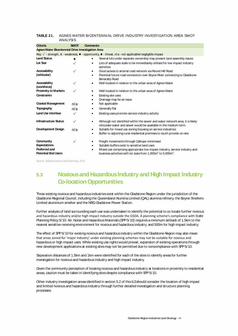
Gladstone Region Industrial Land Strategy 44
TABLE 2 1. AG NES WATER B ICE NTE N NI AL DR IVE I ND U STRY I NVEST IG ATIO N AREA SWOT ANALYSI S
Criteria SWOT Comments
Agnes Water Bicentennial Drive Investigation Area
Key: √ - strength, x - weakness, ● - opportunity, ♠ - threat, n/a - not applicable/negligible impact
Land Status ♠ Several lots under separate ownership may present land assembly issues
Lot Size √ Lots of adequate scale to be immediately utilised for low impact industry activities
Accessibility (vehicular)
√ Good access to arterial road network via Round Hill Road
Potential future road connection over Boyne River connecting to Gladstone Benaraby Road
Accessibility (workforce)
√ Well located in relation to the urban area of Agnes Water
Proximity to Markets √ Well located in relation to the urban area of Agnes Water
Constraints Existing site uses
Drainage may be an issue Coastal Management n/a Not applicable
Topography n/a Generally flat
Land Use Interface √ Existing uses promote service industry activity
Infrastructure Status √ Although not identified within the sewer and water network area, it is likely reticulate water and sewer would be available in the medium term.
Development Design n/a Suitable for mixed use zoning focusing on service industries
Buffer to adjoining rural residential premises to south provide on-site
Community Expectations
√ Freight movements through Calliope minimised
Suitable buffers exist to sensitive land uses Preferred and Potential End Users
Mixed use comprising appropriate low impact industry, service industry and business activities with lot sizes from 1,000m² to 5,000m².
Source: SGS Economics and Planning, 2010
5.3 Noxious and Hazardous Industry and High Impact Industry Co-location Opportunities
Three existing noxious and hazardous industries exist within the Gladstone Region under the jurisdiction of the Gladstone Regional Council, including the Queensland Alumina Limited (QAL) alumina refinery, the Boyne Smelters Limited aluminium smelter and the NRG Gladstone Power Station. Further analysis of land surrounding each use was undertaken to identify the potential to co-locate further noxious and hazardous industry and/or high impact industry outside the GSDA. A planning scheme’s compliance with State Planning Policy 5/10: Air, Noise and Hazardous Materials (SPP 5/10) requires a minimum setback of 1.5km to the nearest sensitive receiving environment for noxious and hazardous industry, and 500m for high impact industry. The effect of SPP 5/10 for existing noxious and hazardous industry within the Gladstone Region may also mean that areas zoned for ‘major industry’ under existing planning schemes may not be suitable for noxious and hazardous or high impact uses. While existing use rights would prevail, expansion of existing operations through new development applications at existing sites may not be permitted due to noncompliance with SPP 5/10. Separation distances of 1.5km and 1km were identified for each of the sites to identify areas for further investigation for noxious and hazardous industry and high impact industry. Given the community perception of locating noxious and hazardous industry at locations in proximity to residential areas, caution must be taken in identifying sites despite compliance with SPP 5/10. Other industry investigation areas identified in section 5.2 of this ILS should consider the location of high impact and limited noxious and hazardous industry through further detailed investigation and structure planning processes.

Gladstone Region Industrial Land Strategy 45
QAL Alumina Refinery
The existing operations of the QAL alumina refinery are buffered by the rural zoning of land under the Gladstone City Planning Scheme. SPP 5/10 requires a minimum separation distance of 1.5km to the nearest sensitive receiving environment for new noxious and hazardous industry use of the site. Figure 16 below shows the QAL site and 1km and 1.5km separation distances. Given the site’s proximity to existing sensitive land uses, particularly Toolooa State High School and residential zones, it is unlikely further development for noxious and hazardous industry would comply with the separation distances of SPP 5/10. Potential does exist however, for the use of limited areas of land to the south of the site for high impact industry uses where they do not encroach within a 500m separation distance to sensitive uses or land zoned for sensitive uses.

Gladstone Region Industrial Land Strategy 46
FIG URE 17. QAL ALU MI NA REF INERY 1 . 5KM AND 1K M SEPAR ATIO N DI STANCES
Source: SGS Economics and Planning, 2010

Gladstone Region Industrial Land Strategy 47
Boyne Smelters Limited, Aluminium Smelter
The Boyne Smelters Limited aluminium smelter operations are buffered by rural and open space zones under the existing Calliope Planning Scheme. Residential areas are located within 1km of existing operations and land zoned for major industry. Any potential for expansion of the existing major industry zone to accommodate further industry activities would occur to the east. Almost all land to the north, south and east of the existing major industry zone is used for the management of ‘red mud’, a waste product of the bauxite refining process. It is unlikely suitable land within 1km of existing BSL operations would be suitable for further noxious and hazardous industry or high impact industry.
FIG URE 18. BOYNE SMELTERS 1 . 5KM AND 1K M SEPAR ATIO N D I STANCES
Source: SGS Economics and Planning, 2010

Gladstone Region Industrial Land Strategy 48
Gladstone Power Station
The QPP version 2.0 technically defines the Gladstone Power Station as a utility installation and therefore may be exempt from the provisions of SPP 5/10. Nevertheless, the offsite impacts of the Power Station are similar to that of a noxious and hazardous industry and therefore should be treated as such for the purposes of this ILS. No sensitive land uses exist within a 1km separation distance to the power station site, however limited land suitable for industry activities exists within this area. Land currently zoned rural to the south of the power station and Calliope River within 1km from the power station site boundary is considered potentially suitable for high impact industry uses and is recommended for further detailed investigation by the Gladstone Regional Council.
FIG URE 19. NRG POWER STATIO N 1 . 5K M AND 1 KM SE PARAT I ON D I STANC ES
Source: SGS Economics and Planning, 2010

Gladstone Region Industrial Land Strategy 49
6 INDUSTRIAL PLANNING AND DEVELOPMENT FRAMEWORK
6.1 Implementation
The availability, quality and delivery of industrial land crosses a number of plans, strategies and jurisdictions within the Gladstone Region. Implementation of the ILS will rely on existing planning mechanisms within the planning and development framework, as well as ensuring its principles are incorporated into future planning strategies. The ILS is intended to be dynamic in that it can be reviewed and amended in response to economic activity such as major projects, population forecasts or changes to legislation or regulation. The ILS is intended to be a non-statutory document, however elements are to be given statutory weight through alignment of the Gladstone Region Planning Scheme. On this basis, a necessary component to the effective implementation of the ILS is the continual monitoring of economic activity and take up of industrial land. Monitoring will ensure an appropriate stock of industrial land is available relative to industry demand through the timely release of industrial land identified within the ILS. This will allow the ILS to respond to industry needs through the early release of industrial land identified as being required in the long term should economic activity dictate so, alternatively industrial land identified for release in the medium-term may be held as long-term industrial land should monitoring indicate an adequate supply. Currently, the Gladstone Region does not currently form part of a statutory regional plan however, when one is developed the ILS should inform, and be informed, by its content. Figure 19 broadly illustrates the planning and development framework of the Gladstone Region and its relationship with the ILS.
FIG URE 20. IND U STRI AL L AND STRATEGY IM PLEME NTAT ION
Source: SGS Economics and Planning, 2010
Strategic Planning
Implementation and Coordination
Statutory Planning
•Economic Development Strategy
•Industrial Land Strategy
•Future Central QLD Regional Plan
•Monitor Economic Activity, Population Growth and Take-up of Industrial Land
•Amend ILS as necessary
•Gladstone Region Planning Scheme
•Port of Gladstone Land Use Plan
•GSDA Development Scheme

Gladstone Region Industrial Land Strategy 50
6.2 State Planning Instruments
While the ILS is a non-statutory strategic document, it is intended to be given statutory weight through the alignment of the Gladstone Region Planning Scheme and by informing a future statutory Regional Plan. Other state planning instruments relevant to the implementation of the ILS include state planning policies and standard planning scheme provisions. While state planning policies (SPPs) have been given broad consideration in the identification of industry investigation areas, detailed assessment is required upon further investigation and should be done so in coordination with the preparation of a new planning scheme. It is noted a number of draft SSPs were under preparation at the time of developing the ILS. State Planning Policy 5/10: Air, Noise and Hazardous Materials (SPP 5/10) was adopted in December 2010 and has direct relevance to the planning, management and development of industrial land. SPP 5/10 aims to protect the environmental values, human safety, and the viability of industrial development through appropriate planning and, where necessary, separation of industrial development from sensitive uses. The ILS addresses the recommendations of the SPP 5/10 through incorporation of its elements in the analysis existing industrial zoned land and providing measures to reduce the conflicts between sensitive land uses and industry through location and local planning instruments such as codes and overlays.
Queensland Planning Provisions
All Queensland planning schemes are required by SPA to comply with the Queensland Planning Provisions (QPP) which provide a consistent format and structure for planning schemes. The QPP provides tools to facilitate the implementation of the ILS at the statutory level through local planning instruments. The QPP provide mandatory and optional components. Elements of the QPP recommended to be utilised for the implementation of the ILS include:
Strategic outcomes, themes and elements
Levels of assessment
Zones
Overlays
Precincts of Zones
Planning scheme policies Implementation of the ILS through the above elements and local planning instruments are discussed in section 6.3 below.
6.3 Local Planning Instruments
Elements of the QPP recommended to be utilised to implement the ILS are discussed in detail below.
Strategic Framework
The strategic framework sets the policy position for the whole planning scheme area and must include the following headings:
Theme;
Strategic outcomes;
Elements;
Specific outcomes;

Gladstone Region Industrial Land Strategy 51
Land use strategies. Industrial land is an element of economic development and therefore is identified within the economic development theme.
Strategic Outcomes The QPP provides a suggested strategic outcome for this theme, which states:
“Economic benefits are maximised through a range of strategies that promote appropriate land uses and minimise conflicts with strategic economic infrastructure. Clustering, co-location and innovative land uses achieve synergies that utilise existing and planned infrastructure and provide opportunities for growth in primary industries and commercial and administrative activities. The provision of land for activities such as tourism, services, research and development and the arts ensures economic diversity and greater variety of employment, as well as meeting the changing needs of the community”.
While the above overall outcome could suffice, additional options for inclusion could include:
“The Gladstone Region’s role as an industrial driver of the Queensland economy is furthered through the appropriate location and supply of industrial (and employment) areas, based on their commercial viability and proximity to necessary infrastructure, transport routes and markets, and are protected from incompatible land uses and development”.
Specific Outcomes and Land Use Strategies for Industrial Land Options for specific outcomes and associated land use strategies for industrial land are provided in Table 22.

Gladstone Region Industrial Land Strategy 52
TABLE 2 2. SU G GESTED SPECI FI C O U TCOMES AND LAND U SE ST R ATEG IES FOR I NDU S TRY ZONE D L AND
Specific Outcomes Land Use Strategies
Ensure an adequate supply of industrial land through monitoring of major project commitment; population growth; and, industrial land take up.
Establish monitoring programmes to inform and update industrial land supply and demand projections.
Encourage the co-location of industrial areas and major infrastructure such as the Port of Gladstone, arterial roads, rail infrastructure, electricity infrastructure, high impact industries, and the GSDA.
Industrial land is located in proximity to the GSDA, major infrastructure, or where there is demonstrated need, where appropriate.
Integrate infrastructure planning with the provision of industrial land.
Medium to long term industrial land supplies are located in areas that have the ability to be serviced by necessary trunk infrastructure under the Priority Infrastructure Plan.
Identify and protect strategic and future industrial land from incompatible land uses.
Medium to long term industrial land areas identified within the ILS are protected from incompatible land uses through industry investigation zones and appropriate buffer distances.
Extend existing industrial precincts where appropriate.
Existing industrial precincts identified within the ILS maximise the efficient use of land by extending industrial land areas, where appropriate.
Consolidate and promote the efficient use of industrial zoned land.
The efficiency of industrial land is promoted through the consolidation of industrial areas and the use of reciprocal infrastructure and services such as access easements, office space and social amenities.
The location of industry zones and uses are suitably located away from sensitive receiving environments and protected from encroachment by incompatible uses by complying with the requirements of State Planning Policy 5/10 Air, Noise and Hazardous Materials
Industrial land uses (particularly uses for medium impact, high impact, extractive, and noxious and hazardous industry) are directed away from land uses that are sensitive or at risk from the impacts of industry.
Industry zones (particularly medium impact, high impact, extractive, and noxious and hazardous industry zones) are protected from encroachment by sensitive land uses.
Industrial land within a state development area, enterprise opportunity area or emerging major employment area in a regional plan, is protected from encroachment by sensitive land uses.
Intensive animal industries are directed away from urban areas and protected from encroachment by sensitive land uses.
Where appropriate, encourage high impact industry and noxious and hazardous industry to locate within the GSDA.
Appropriate precincts of the GSDA are identified as a High Impact Industry Zone that can cater for noxious and hazardous industries.
High impact and noxious hazardous industry not suitable for location within the GSDA is accommodated at suitable locations within existing industry zones.
Existing industry precincts and new industry areas are structure planned, or contain precincts that identify locations suitable for high impact or noxious and hazardous industry.
Where appropriate, encourage marine and waterfront industry to locate on strategic port land.
Strategic Port Land suitable for industrial development as provided for in the Port of Gladstone Land Use Plan is identified as a Waterfront and Marine Industry Zone.

Gladstone Region Industrial Land Strategy 53
Specific Outcomes Land Use Strategies
Waterfront and marine industry and port services not located on strategic port land are suitably located away from land uses that may be sensitive or impacted by industry activity, have access to necessary infrastructure and services and does not adversely impact the operations of the Port of Gladstone.
Existing and new industry areas are structure planned, or contain precincts that identify locations suitable for waterfront and marine industry.
Employment areas are located within proximity to urban settlements to provide essential commercial services to residents and improve journey to work distances and time.
Industry servicing local needs is identified as Low Impact Industry, Service Industry or Mixed Use Zones depending on their function and proximity to sensitive land uses.
Encourage the use of appropriate land uses as buffers between industrial areas and sensitive land uses.
Appropriate land separation distances between industrial land and sensitive land uses are zoned Limited Development, Recreation, Centres, or Mixed Use depending on the sensitivity of the nearest non-industrial urban environment.
Existing and new industry areas contain precincts that allocate appropriate industrial uses to areas based on their impact and sensitivity to nearby land uses and land use zones.
Allow flexibility to accommodate a mix of service industry uses in townships.
Allow for flexibility within the township zone code to establish low-impact industries based on their impact to surrounding land uses.
Encourage appropriate home based businesses with minimal impact to adjoining residential uses, particularly in villages, townships and rural residential areas.
Provide for appropriate low-impact industry uses that service the local market to be established under self, compliance, code and impact assessable assessment levels under a home-based business code.
Encourage utility installations, excluding network infrastructure, to be co-located with industry areas in proximity to the catchments they intend to service.
Consider locations for utility installations, particularly those with off-site impacts, when identifying industry investigation areas or when structure planning industry investigation areas.
Source: SGS Economics and Planning, 2010

Gladstone Region Industrial Land Strategy 54
Zones
The zones determined to best reflect the local context of the Gladstone Region provided within the QPP for industrial uses are provided in Table 23 below. For each zone, the QPP provides a standard purpose statement and suggested overall outcomes which can be adopted by the local government. The standard purpose statement for each zone is mandatory however must be refined to reflect the local context, however suggested overall outcomes can be utilised, modified or redrafted by the local government. The overall outcomes provided within the QPP considered appropriate to industrial land within the Gladstone Region are provided in the final column of Table 23. It is noted that a High Technology Zone has not been recommended for the Gladstone Region given the limited demand expected for this zone type. Instead, areas suitable for research and technology type uses should be identified within precincts of local plans or structure plans, or suitably facilitated within mixed use zones where appropriate.
TABLE 2 3. RECOM MENDED I ND U STRY ZO NES AND OVER ALL OU TCOMES
Zone Purpose Statement Overall Outcomes
Low Impact Industry (1) The purpose of the zone is to provide for service and low-impact industry uses. It may include non-industrial and business uses that support the industrial activities where they do not compromise the long-term use of the land for industrial purposes. Activities considered appropriate in this zone are defined as low-impact industry or service industry in the schedule of definitions. (2) The local government purpose is to ensure suitably located areas and precincts, with proximity and access to markets and infrastructure, are available within the Gladstone Region that protect, encourage and facilitate investment in low impact industry, service industry and warehouse uses that meet end user needs. Business activities that support the long term use and primary use of the zone for industrial purposes, facilitate the co-location of supply chain elements, and provide employees and customers with access to day to day services, are supported.
A range of industrial uses that satisfy the purpose of the zone will be facilitated.
Non-industrial uses, such as offices, short- term accommodation and retail uses, which are ancillary to and directly support the industrial area are facilitated.
Uses and works for industrial purposes are located, designed and managed to maintain safety to people, avoid significant adverse effects on the natural environment and minimise impacts on adjacent nonindustrial land.
Development is designed to incorporate sustainable practices including maximising energy efficiency, water conservation and transport use.
Development is reflective of and responsive to the environmental constraints of the land.
The scale, character and built form of development contributes to a high standard of amenity.
Development has access to development infrastructure and essential services.
The viability of both existing and future low impact industry uses are protected from the intrusion of incompatible uses.
Adverse impacts on natural features and processes both on-site and from adjoining areas are minimised through location, design, operation and management of development.
Industrial uses are adequately separated from sensitive land uses to minimise the likelihood of environmental harm or environmental nuisance occurring.
Development provides a range and mix of lot sizes to meet end user needs, including larger lots, and prevents the inefficient fragmentation of industrial land.
Medium Impact Industry
The purpose of the zone is to provide for medium impact industry uses. It may include non-industrial and business uses that support the industrial activities where they do not compromise the long-term use of the land for industrial purposes.
A range of industrial uses that satisfy the intent of the zone will be facilitated.
Residential uses are not located within close proximity to the industrial uses and activities in the zone.
Service and low-impact industry uses may be appropriate where they are not detrimentally

Gladstone Region Industrial Land Strategy 55
Zone Purpose Statement Overall Outcomes
Activities considered appropriate in this zone are defined as medium impact industry in the schedule of definitions. (2) The local government purpose is to ensure suitably located areas and precincts, with proximity and access to markets and infrastructure, are available within the Gladstone Region that protect, encourage and facilitate investment in medium impact industry and warehouse uses that meet end user needs. Medium impact industry zones facilitate favourable market conditions for medium impact industry end users by protecting medium impact industry from encroachment by incompatible land uses and are suitably distanced from land uses that are sensitive or at risk from the impacts of industry. Areas suitable for high impact industry and noxious and hazardous industry not suitable for location within the Gladstone State Development Area are directed toward suitable locations within the medium industry zone and protected by precinct provisions. Limited lower order industrial activities and business activities that support the long term use of the land for industrial purposes, facilitate the co-location of supply chain elements, and provide employees with access to day to day services, may be supported.
affected by or compromise the operations of medium impact industry uses, or affect the supply of medium impact industry land.
Non-industrial uses, such as offices, short- term accommodation and retail uses, which are ancillary to and directly support the industrial area are facilitated.
Uses and works for industrial purposes are located, designed and managed to maintain safety to people, avoid significant adverse effects on the natural environment and minimise impacts on adjacent nonindustrial land.
Development is designed to incorporate sustainable practices including maximising energy efficiency, water conservation and transport use.
Development is reflective of and responsive to the environmental constraints of the land.
The scale, character and built form of development contributes to a high standard of amenity.
Development has access to development infrastructure and essential services.
The viability of both existing and future medium impact industry uses are protected from the intrusion of incompatible uses.
Adverse impacts on natural features and processes both on-site and in adjoining areas are minimised through location, design, operation and management of development.
Industrial uses are adequately separated from sensitive land uses to minimise the likelihood of environmental harm or environmental nuisance occurring.
Development provides a range and mix of lot sizes to meet end user needs, including larger lots, and prevents the inefficient fragmentation of industrial land .
High Impact Industry (1) The purpose of the zone is to provide for high impact industry uses. It may include non-industrial and business uses that support the industrial activities where they do not compromise the long-term use of the land for industrial purposes. Activities considered appropriate in this zone are defined as high impact industry in the schedule of definitions. (2) The local government purpose is to minimize the impacts of high impact industry on the health, wellbeing, amenity and safety of communities and individuals while protecting existing and future high impact industries from encroachment by incompatible land uses. High impact industries are encouraged to locate within the GSDA. Where high impact industries are unsuitable for location within the GSDA, they are located
A range of industrial uses that satisfy the intent of the zone will be facilitated.
Residential uses are not located within close proximity to the industrial uses and activities in the zone.
Industrial business activity is facilitated where it is appropriately located and designed to protect industrial activities from encroachment by nonindustrial uses.
Non-industrial uses, such as offices, short-term accommodation and retail uses, which are ancillary to and directly support the industrial area are facilitated.
Uses and works for industrial purposes are located, designed and managed to maintain safety to people, avoid significant adverse effects on the natural environment and minimise impacts on adjacent nonindustrial land.
Development maximises the use of existing transport infrastructure and has access to the appropriate level of transport infrastructure (railways and motorways) and facilities such as airports and seaports.
Development is designed to incorporate sustainable practices including maximising energy efficiency, water conservation and

Gladstone Region Industrial Land Strategy 56
Zone Purpose Statement Overall Outcomes
transport use.
Development is reflective of and responsive to the environmental constraints of the land.
The scale, character and built form of development contributes to a high standard of amenity.
Development has access to development infrastructure and essential services.
The viability of both existing and future service industry uses are protected from the intrusion of incompatible uses.
Any sensitive uses located in the service industry zone do not compromise the viability of both existing and future industry uses in any other industry zone.
Adverse impacts on natural features and processes both on-site and from adjoining areas are minimised through location, design, operation and management of development.
Industrial uses are adequately separated from sensitive land uses to minimise the likelihood of environmental harm or environmental nuisance occurring.
Hazardous and Noxious Industry
(1) The purpose of the zone is to provide for noxious and hazardous industry uses. It may include non-industrial and business uses that support the industrial activities where they do not compromise the long-term use of the land for industrial purposes. Activities considered appropriate in this zone are defined as noxious and hazardous industry in the schedule of definitions. (2) The local government purpose is to minimize the impacts of hazardous and noxious industry on the health, wellbeing, amenity and safety of communities and individuals while protecting existing and future hazardous and noxious industries from encroachment by incompatible land uses.
A range of noxious and hazardous industrial uses that satisfy the intent of the zone will be facilitated.
Residential uses are not located within close proximity to the industrial uses and activities in the zone.
Non-industrial uses, such as offices and retail uses, which are ancillary to and directly support the industrial area are facilitated.
Uses and works for noxious and hazardous industrial purposes are located, designed and managed to maintain safety to people, avoid significant adverse effects on the natural environment and minimize impacts on adjacent non-industrial land having regard to the inherent risks associated with these types of industries.
Development is designed to incorporate sustainable practices including maximising energy efficiency, water conservation and transport use.
Development is reflective of and responsive to the environmental constraints of the land.
The scale, character and built form of development contributes to a high standard of amenity.
Development has access to development infrastructure and essential services.
The viability of both existing and future noxious and hazardous industry uses are protected from the intrusion of incompatible uses.
Any sensitive uses located in the noxious and hazardous industry zone do not compromise the viability of both existing and future industry uses in any other industry zone.
Adverse impacts on natural features and processes both on-site and from adjoining areas are minimised through location, design, operation and management of development.
Industrial uses are adequately separated from sensitive land uses to minimise the likelihood of environmental harm or environmental
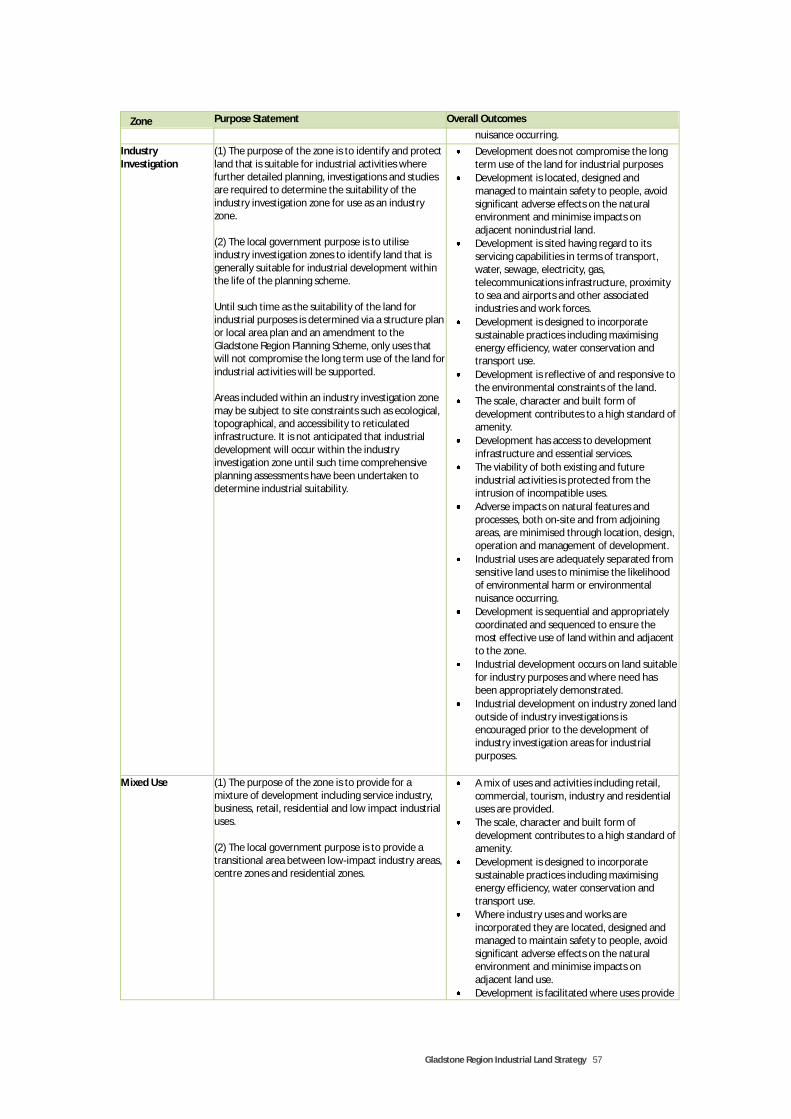
Gladstone Region Industrial Land Strategy 57
Zone Purpose Statement Overall Outcomes
nuisance occurring.
Industry Investigation
(1) The purpose of the zone is to identify and protect land that is suitable for industrial activities where further detailed planning, investigations and studies are required to determine the suitability of the industry investigation zone for use as an industry zone. (2) The local government purpose is to utilise industry investigation zones to identify land that is generally suitable for industrial development within the life of the planning scheme. Until such time as the suitability of the land for industrial purposes is determined via a structure plan or local area plan and an amendment to the Gladstone Region Planning Scheme, only uses that will not compromise the long term use of the land for industrial activities will be supported. Areas included within an industry investigation zone may be subject to site constraints such as ecological, topographical, and accessibility to reticulated infrastructure. It is not anticipated that industrial development will occur within the industry investigation zone until such time comprehensive planning assessments have been undertaken to determine industrial suitability.
Development does not compromise the long term use of the land for industrial purposes
Development is located, designed and managed to maintain safety to people, avoid significant adverse effects on the natural environment and minimise impacts on adjacent nonindustrial land.
Development is sited having regard to its servicing capabilities in terms of transport, water, sewage, electricity, gas, telecommunications infrastructure, proximity to sea and airports and other associated industries and work forces.
Development is designed to incorporate sustainable practices including maximising energy efficiency, water conservation and transport use.
Development is reflective of and responsive to the environmental constraints of the land.
The scale, character and built form of development contributes to a high standard of amenity.
Development has access to development infrastructure and essential services.
The viability of both existing and future industrial activities is protected from the intrusion of incompatible uses.
Adverse impacts on natural features and processes, both on-site and from adjoining areas, are minimised through location, design, operation and management of development.
Industrial uses are adequately separated from sensitive land uses to minimise the likelihood of environmental harm or environmental nuisance occurring.
Development is sequential and appropriately coordinated and sequenced to ensure the most effective use of land within and adjacent to the zone.
Industrial development occurs on land suitable for industry purposes and where need has been appropriately demonstrated.
Industrial development on industry zoned land outside of industry investigations is encouraged prior to the development of industry investigation areas for industrial purposes.
Mixed Use (1) The purpose of the zone is to provide for a mixture of development including service industry, business, retail, residential and low impact industrial uses. (2) The local government purpose is to provide a transitional area between low-impact industry areas, centre zones and residential zones.
A mix of uses and activities including retail, commercial, tourism, industry and residential uses are provided.
The scale, character and built form of development contributes to a high standard of amenity.
Development is designed to incorporate sustainable practices including maximising energy efficiency, water conservation and transport use.
Where industry uses and works are incorporated they are located, designed and managed to maintain safety to people, avoid significant adverse effects on the natural environment and minimise impacts on adjacent land use.
Development is facilitated where uses provide

Gladstone Region Industrial Land Strategy 58
Zone Purpose Statement Overall Outcomes
a compact urban form.
Development activates street frontages, promotes a mix of employment opportunities and enhances walking, cycling and public transport use.
New development complements and preserves existing heritage and character.
Development is reflective of and responsive to the environmental constraints of the land.
Development has access to development infrastructure and essential services.
Significant historical, architectural, topographic, landscape, scenic, social, recreational and cultural features and associations, as well as natural habitat areas, wildlife corridors, wetlands and waterway corridors are protected and enhanced.
Source: SGS Economics and Planning, 2011
FIG URE 21. EXI ST I NG AND PROPO SE D I ND U STRY ZONING FR AME WORK
Source: SGS Economics and Planning, 2010
Precincts of Zones
For the purpose of clarity and ease of understanding, the overall purpose of the planning scheme should be to minimise planning regulation. The use of planning tools such as precincts and local area plans have the ability to minimise regulation through providing specific directions for a given area and altering the overall outcomes or levels of assessment. While the use of precincts has been used in the ILS to identify industrial areas within the Gladstone Region, they may not necessarily transfer directly to the use of precincts within the planning scheme. For example, industrial precincts may be amalgamated to provide a broader area planning intent, such as the area comprising the Blain

Gladstone Region Industrial Land Strategy 59
Drive, Clinton and Callemondah industry areas. In some circumstances the use of industry zones may be appropriate to achieve the outcomes of particular industry areas. On balance, however, it is recommended that precincts are utilised to achieve specific industrial outcomes for a number of localities such as:
preserving an appropriate mix of lot sizes within a given area to ensure a variety industry sectors are catered for;
supporting or discouraging particular industry types within a precinct;
minimising planning regulation for supported industry types within appropriate precincts; and
protect industrial areas from incompatible development. It is recommended the ILS be used as a guide in developing suitable precinct planning outcomes where appropriate.
Level of Assessment
The QPP stipulates tables of assessment are provided for zones, local plans, overlays and reconfiguring a lot and operational works (if used) and that each zone, local plan and overlay have their own table. Levels of assessment are to be determined by the local government, however the QPP recommends that the levels of assessment tables be grouped by categories of land use such as residential or industrial. Table 24 provides possible levels of assessment for the industry category of zones for relevant defined uses under Schedule 1 of the QPP.

Gladstone Region Industrial Land Strategy 60
TABLE 2 4. SU G GESTED LEVEL OF A SSESSME NT FOR INDU ST RY ZO NE TYPES
Use Category Defined Use Level of Assessment Assessment Criteria
Low Impact Industry Zone
Business Activity bulk landscape supplies Code/Impact Low impact industry zone code
Industry design code
Precinct intent and outcomes where applicable
Relevant overlay codes
Specific use and development codes
food & drink outlet Code/Impact
garden centre Code/Impact
hardware and trade supplies Code/Impact
office Code/Impact
outdoor sales Code/Impact
sales office Compliance
service industry Compliance/Code
shop Code/Impact
showroom Code/Impact
Rural Activity agricultural supplies store Code/impact
rural industry Impact
wholesale nursery Impact
Industry Activity service industry Compliance/Code
low impact industry Compliance/Code
medium impact industry Impact
high impact industry Impact
noxious & hazardous industry Impact
research & technology industry Code/Impact
warehouse Code/Impact
waterfront & marine industry Impact
Recreation Activity indoor sport and recreation Code/Impact
Medium Impact Industry
Business Activity bulk landscape supplies Code/Impact Medium impact industry zone code
Industry design code
Precinct intent and outcomes where applicable
Relevant overlay codes
Specific use and development codes
food & drink outlet Code/Impact
garden centre Impact
hardware and trade supplies Impact
office Code/Impact
outdoor sales Code/Impact
sales office Compliance
service industry Impact
shop Impact
showroom Impact
Rural Activity agricultural supplies store Code/Impact
rural industry Code/Impact
wholesale nursery Impact
Industry Activity service industry Impact
low impact industry Impact
medium impact industry Compliance/Code
high impact industry Impact
noxious & hazardous industry Impact
research & technology industry Code/Impact
warehouse Compliance/Code
waterfront & marine industry Impact
Recreation Activity indoor sport and recreation Impact
Other Utility installation Code/Impact
High Impact Industry Zone
All Activities All uses Impact Gladstone State Development Area Development Scheme
Noxious and Hazardous Industry Zone
All Activities All uses Impact Gladstone State

Gladstone Region Industrial Land Strategy 61
Use Category Defined Use Level of Assessment Assessment Criteria
Development Area Development Scheme
Waterfront and Marine Industry Zone
All Activities Waterfront and marine industry Impact
Mixed Use Zone
Business Activity bulk landscape supplies Code/Impact Mixed use zone code
Industry design code
Precinct intent and outcomes where applicable
Relevant overlay codes
Specific use and development codes
food & drink outlet Compliance/Code
garden centre Code/Impact
hardware and trade supplies Code/Impact
office Code/Impact
outdoor sales Code/Impact
sales office Code/Impact
service industry Code/Impact
shop Code/Impact
showroom Code/Impact
Rural Activity agricultural supplies store Impact
rural industry Impact
wholesale nursery Impact
Industry Activity service industry Code/Impact
low impact industry Code/Impact
medium impact industry Impact
high impact industry Impact
noxious & hazardous industry Impact
research & technology industry Code/Impact
warehouse Code/Impact
waterfront & marine industry Impact
Recreation Activity indoor sport & recreation Code/Impact
Industry Investigation Zone
All Activities All uses Impact Industry investigation zone code; and/or
Subject to detailed structure plan
Source: SGS Economics and Planning, 2011
Industry Codes
Industrial land use and development has been regulated in each planning sector through their respective planning schemes. Upon review of industry codes relating to each planning sector a number of consistent outcomes are identified, including:
Limiting commercial and business services within industrial zoned areas;
Preserve land within industry zones for industry uses;
Protect industrial zoned land from encroaching incompatible land uses;
Provide adequate buffers between industrial areas and sensitive land uses;
Managing the land use interface between industrial zoned land and other land uses;
Minimising emissions and mitigating the adverse environmental, visual, odour, acoustic, waste impacts of industrial land uses;
Minimising impacts on surrounding land uses;
Incorporating landscaping and design elements to provide attractive street frontages and screens; and
Protecting the existing road network from transport servicing industrial areas. Despite these areas of consistency, the outcomes for industrial areas vary between precincts and planning sectors. For example, it is inappropriate to have the same standards for industrial development in Agnes Waters and Gladstone City given the difference in local characteristics and economic conditions. While overall outcomes may

Gladstone Region Industrial Land Strategy 62
be similar, acceptable solutions may warrant variations between precincts and planning sectors to reflect local conditions or specific directions for particular localities. General topics suitable for inclusion in the Industry Zone Codes include:
Protection of industrial areas;
Buffer requirements;
Interface treatments;
Lot size and mix;
Built form;
Density;
Visual amenity;
Emissions including noise, air pollutants, light, waste and stormwater;
Stormwater management;
Security;
Public Safety;
Vehicular Access and Car Parking;
Energy efficiency;
Sustainability; and
Structure planning. The QPP requires each zone to have a zone code, which must include:
A mandatory purpose statement;
A local government purpose statement; and
Overall outcomes that achieve the purpose of the code. The QPP also identifies mechanisms which codes may also include, such as:
Performance outcomes and acceptable solutions;
Graphics to articulate criteria for assessment; and
Altering provisions for precincts An Industry Activity Code is provided below that provides performance outcomes and acceptable solutions that further the implementation of the ILS and would be suitable, with local refinement, for the inclusion in the Gladstone Region Planning Scheme.
Industry Activity Code
The purpose of the code will be achieved through the following overall outcomes: a) establish industrial activities in appropriate locations that meet end user needs in terms of proximity to
infrastructure, transport, markets and sensitive land uses; b) provide for a range of industrial activities to facilitate sustainable economic development for the Region; c) establish and operate industrial activity on premises within the Low Impact Industry Zone, Medium
Impact Industry Zone and Mixed Use Zone; d) encourage high impact and noxious and hazardous industries to locate within the Gladstone State
Development Area; e) facilitate high impact and noxious and hazardous industries that cannot be located within the Gladstone
State Development Area within appropriate high impact and noxious and hazardous industry zones or appropriate precincts of the medium impact industry zone;
f) establish industrial activity that is compatible with the outcomes of industrial precincts; g) provide industrial development that caters for various industry sectors and end users needs; h) protect industrial zoned land and industry investigation zones from incompatible development; i) protect sensitive land uses from the effects of industrial development; j) provide for the efficient use of industry zoned land and buffer areas; k) ensure industry activity operates within acceptable environmental standards and manages operational
risks and hazards and polluting emissions

Gladstone Region Industrial Land Strategy 63
TABLE 2 5. SU G GESTED PER FORM ANC E OUTCOMES AND AC CEP TABLE OU TCO MES FOR IND U STRY COD ES
PO Performance Outcomes AO Acceptable Outcomes
Site Suitability and Separation
PO1 Industry and industry compatible uses are established on appropriate sites that do not compromise the ongoing operations and future economic opportunities of industrial zones to cater for industrial activities, including industrial land in a state development area. Industry sensitive land uses are located at an appropriate distance from industrial activities with regard to:
Noise;
Odour;
Air quality;
Lighting;
Hours of operation; and
Heavy vehicle movements.
AO1.1 A01.2 AO1.3 AO1.4
Industry activities are located in zones or precincts intended to support the proposed use. Minimum separation distances between industrial development and industry sensitive development are:
Medium Impact Industry – 250m
High Impact Industry – 500m
Noxious and Hazardous Industry – 1500m Compatible development that does not compromise the ongoing operations of higher order industrial development is encouraged within minimum separation distances in accordance with Figure 21. High impact and noxious and hazardous industries are located within the Gladstone State Development Area; or Where high impact and noxious and hazardous industries are not suitable for location within the GSDA they are located within industrial zoned areas in accordance with AO1.1 and 1.2
PO2 Industrial development (particularly high impact, noxious and hazardous and extractive industries) does not result in sensitive land use being exposed to industrial air, noise, and odour emissions that impact human health, amenity and well being.
AO2.1 AO2.2
The use is designed to ensure that:
the indoor noise objectives set out in the Environmental Protection (Noise) Policy 2008 are met
the air quality objectives in the Environmental Protection (Air) Policy 2008, and any relevant national or international standard (for example, the World Health Organisation Guidelines for Air Quality 2000) are met.
Design measures could include:
landscaping;
setting back sensitive land uses from existing and future industrial noise sources
positioning buildings in the most appropriate geographic locations (e.g. placing bedrooms away from existing and future industrial noise sources)
using barriers, mounds and fences
screening sensitive land uses from industrial noise sources.
Note: air and/or noise impact assessments should be prepared by a suitably qualified professional to demonstrate compliance with acceptable outcome AO2.1. Noxious and offensive odours are not experienced at the location of sensitive uses. Note: the Queensland Odour Impact Assessment Guideline provides a methodology for assessing odour impacts.
Other uses compatible with industrial activity are provided to serve the immediate workforce, have a direct nexus to industrial activities, and are easily accessed by businesses and employees within industry zones.
Compatible business, rural, and recreational activities: are located central to the industrial area it serves; or are located on a collector, or higher order road; and do not exceed 250m² of gross floor area.
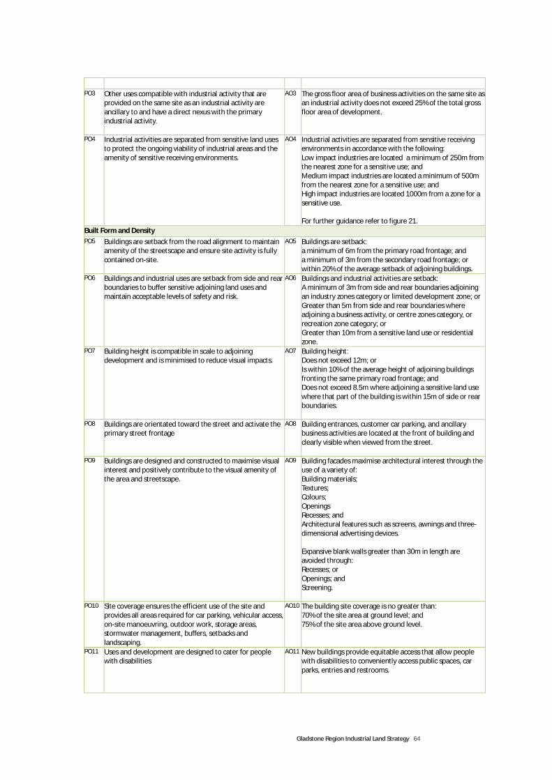
Gladstone Region Industrial Land Strategy 64
PO3 Other uses compatible with industrial activity that are provided on the same site as an industrial activity are ancillary to and have a direct nexus with the primary industrial activity.
AO3 The gross floor area of business activities on the same site as an industrial activity does not exceed 25% of the total gross floor area of development.
PO4 Industrial activities are separated from sensitive land uses to protect the ongoing viability of industrial areas and the amenity of sensitive receiving environments.
AO4 Industrial activities are separated from sensitive receiving environments in accordance with the following: Low impact industries are located a minimum of 250m from the nearest zone for a sensitive use; and Medium impact industries are located a minimum of 500m from the nearest zone for a sensitive use; and High impact industries are located 1000m from a zone for a sensitive use. For further guidance refer to figure 21.
Built Form and Density
PO5 Buildings are setback from the road alignment to maintain amenity of the streetscape and ensure site activity is fully contained on-site.
AO5 Buildings are setback: a minimum of 6m from the primary road frontage; and a minimum of 3m from the secondary road frontage; or within 20% of the average setback of adjoining buildings.
PO6 Buildings and industrial uses are setback from side and rear boundaries to buffer sensitive adjoining land uses and maintain acceptable levels of safety and risk.
AO6 Buildings and industrial activities are setback: A minimum of 3m from side and rear boundaries adjoining an industry zones category or limited development zone; or Greater than 5m from side and rear boundaries where adjoining a business activity, or centre zones category, or recreation zone category; or Greater than 10m from a sensitive land use or residential zone.
PO7 Building height is compatible in scale to adjoining development and is minimised to reduce visual impacts.
AO7 Building height: Does not exceed 12m; or Is within 10% of the average height of adjoining buildings fronting the same primary road frontage; and Does not exceed 8.5m where adjoining a sensitive land use where that part of the building is within 15m of side or rear boundaries.
PO8 Buildings are orientated toward the street and activate the primary street frontage
AO8 Building entrances, customer car parking, and ancillary business activities are located at the front of building and clearly visible when viewed from the street.
PO9 Buildings are designed and constructed to maximise visual interest and positively contribute to the visual amenity of the area and streetscape.
AO9 Building facades maximise architectural interest through the use of a variety of: Building materials; Textures; Colours; Openings Recesses; and Architectural features such as screens, awnings and three-dimensional advertising devices. Expansive blank walls greater than 30m in length are avoided through: Recesses; or Openings; and Screening.
PO10 Site coverage ensures the efficient use of the site and provides all areas required for car parking, vehicular access, on-site manoeuvring, outdoor work, storage areas, stormwater management, buffers, setbacks and landscaping.
AO10 The building site coverage is no greater than: 70% of the site area at ground level; and 75% of the site area above ground level.
PO11 Uses and development are designed to cater for people with disabilities
AO11 New buildings provide equitable access that allow people with disabilities to conveniently access public spaces, car parks, entries and restrooms.
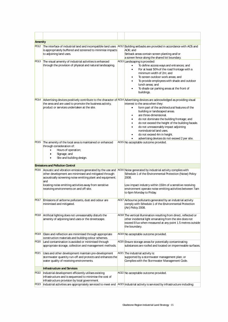
Gladstone Region Industrial Land Strategy 65
Amenity
PO12 The interface of industrial land and incompatible land uses is appropriately buffered and screened to minimise impacts to adjoining land uses.
AO12 Building setbacks are provided in accordance with AO5 and AO6; and Setback areas contain screen planting and/or a screen fence along the shared lot boundary.
PO13 The visual amenity of industrial activities is enhanced through the provision of physical and natural landscaping.
AO13 Landscaping is provided:
To define access ways and entrances; and
For at least 50% of the road frontage with a minimum width of 2m; and
To screen outdoor work areas; and
To provide employees with shade and outdoor lunch areas; and
To shade car parking areas at the front of buildings.
PO14 Advertising devices positively contribute to the character of
the area and are used to promote the business activity, product or services undertaken at the site.
AO14 Advertising devices are acknowledged as providing visual interest to the area when they:
form part of the architectural features of the building or landscaped areas.
are three-dimensional.
do not dominate the building frontage; and
do not exceed the height of the building facade.
do not unreasonably impact adjoining nonindustrial land uses.
do not exceed 4m in height.
advertising devices do not exceed 2 per site. PO15 The amenity of the local area is maintained or enhanced
through consideration of:
Hours of operation;
Signage; and
Site and building design.
AO15 No acceptable outcome provided.
Emissions and Pollution Control
PO16 Acoustic and vibration emissions generated by the use and other development are minimised and mitigated through: acoustically screening noise emitting plant and equipment; and locating noise emitting activities away from sensitive receiving environments on and off-site.
AO16 Noise generated by industrial activity complies with Schedule 1 of the Environmental Protection (Noise) Policy 2008. Low impact industry within 150m of a sensitive receiving environment operate noise emitting activities between 7am to 6pm Monday to Friday.
PO17 Emissions of airborne pollutants, dust and odour are minimised and mitigated.
AO17 Airbourne pollutants generated by an industrial activity comply with Schedule 1 of the Environmental Protection (Air) Policy 2008.
PO18 Artificial lighting does not unreasonably disturb the amenity of adjoining land uses or the streetscape.
AO18 The vertical illumination resulting from direct, reflected or other incidental light emanating from the site does not exceed 8 lux when measured at any point 1.5 metres outside the boundary.
PO19 Glare and reflection are minimised through appropriate construction materials and building colour schemes.
AO19 No acceptable outcome provided.
PO20 Land contamination is avoided or minimised through appropriate storage, collection and management methods.
AO20 Ensure storage areas for potentially contaminating substances are roofed and located on impermeable surfaces.
PO21 Uses and other development maintain pre-development stormwater quantity run-off and protects and enhances the water quality of receiving environments.
AO21 The industrial activity is: supported by a stormwater management plan; or Complies with the Stormwater Management Code.
Infrastructure and Services
PO22 Industrial development efficiently utilises existing infrastructure and is sequenced to minimise the cost of infrastructure provision by local government.
AO22 No acceptable outcome provided.
PO23 Industrial activities are appropriately serviced to meet end AO23 Industrial activity is serviced by infrastructure including:

Gladstone Region Industrial Land Strategy 66
user needs and standards. Reticulated water; and Reticulate sewerage; and Electricity; and Telecommunications.
PO24 Stormwater management is incorporated into site design and layout and meets run-off quantity and quality objectives.
AO24 The industrial activity is: supported by a stormwater management plan; or Complies with the Stormwater Management Code.
PO25 Waste and recycling are managed to minimise impacts on the environment and adjoining properties.
AO25 Waste and recycling storage areas: Are provided on-site; Are located on impermeable surfaces; Are of adequate volume to cater for the waste generated by the use; Are screened to maintain the visual amenity of the area.
Security
PO26 Buildings and spaces are designed in accordance with the principles of Crime Prevention Through Environmental Design (CPTED), including: Facilitation of casual surveillance Minimisation of concealed areas Illumination of public areas and access ways; Creation of legible space and buildings
AO26 No acceptable solution provided.
PO27 Screening and fences are designed to contribute to the streetscape, protect private property, allow surveillance of the street from the building, and are not overly intrusive or dominating
AO27 Screening and fences: Allow the building to be visible from the road frontage; Security fencing is parallel to the building facade, or behind the front boundary setback.
Vehicular Access and Car Parking
PO28 Vehicle access, car parks and service delivery areas minimise vehicular, cyclist and pedestrian conflicts on and off-site.
AO28 Industrial development ensures: All vehicles are capable of entering and leaving the site in a forward motion; Adequate area is provided on-site for vehicle manoeuvring; Heavy vehicle movements are separated from light vehicle movement, where possible; Pedestrian movement and access are separated from vehicular movement areas; Vehicular movement and car parking areas are clearly articulated through line marking and signage.
PO29 Vehicular access and car parking cater for the type and volume of vehicles accessing the site.
AO29 Vehicular access and car parking areas: Are accessed via a driveway crossover that is of suitable width to cater the expected volume of vehicles accessing the site; Provide adequate vehicle queing space on-site commensurate with the number of vehicles likely to utilise the site; Provide staff and customer car parking in accordance with Council’s car parking standards; Distinguish staff and customer car parking spaces.
PO30 Traffic and pedestrian access is safe and convenient. AO30 Vehicular and pedestrian access are: provided from the primary road frontage; and visible and legible when viewed from the street.
Lot Size and Mix
PO31 Industrial zones provide lots that cater for a variety end user needs.
AO31 Industry activities have the following minimum lot sizes: Service Industry - 1,000m² and 20m frontage; Low Impact Industry – 2,000m² and 30m frontage; Medium Impact Industry – 3,000m² and 40m frontage; High impact industry – 10,000m² and 60m frontage. AND Minimum lot sizes and frontages can be less than the identified minimum where reciprocal access easements are shared between two lots that allow shared vehicular access and manoeuvring over a shared lot boundary. The reduction in area and frontage is directly equivalent to the area and frontage saved by each respective lot by sharing access

Gladstone Region Industrial Land Strategy 67
arrangements.
PO32 Industrial zones and precincts provide a mix of lot sizes that cater for a variety industry sectors.
A032 Industrial subdivisions and estates provide a mix of lots sizes with a minimum of 30% of the developable area of an industrial precinct dedicated to lots greater than twice the minimum lot size for each respective zone.
Source: SGS Economics and Planning, 2011
FIG URE 22. ACCEPTABLE MI NI MU M S E PAR ATIO N DI STANCES BETWEEN SE NSIT IVE LA ND USES AND I ND U STRY US ES
Source: SGS Economics and Planning, 2010
250m
High Impact Industry Residential
Activity Zone
Low Impact Industry
Medium Impact
Industry
Noxious and Hazardous Industry
250m 1000m
1,500m
500m

Gladstone Region Industrial Land Strategy 68

Gladstone Region Industrial Land Strategy 69
7 APPENDICES
7.1 Appendix A – Consultation List
Name
Organisation
Tracey Beath Department of Environment & Resource Management
Don Arnold Department of Environment & Resource Management
Peter Dougherty Department of Employment, Economic Development & Innovation, Gladstone Centre
Donn Berghofer Department of Infrastructure & Planning (State Development Areas)
Theo Riethmuller Department of Infrastructure & Planning (State Development Areas)
Ben Thurecht Department of Infrastructure & Planning (Industrial Land Analysis & Planning)
Bob Abnett Department of Infrastructure & Planning (Industrial Land Analysis & Planning)
John White Department of Infrastructure & Planning (Property Services Group)
Shane Jahnke Department of Infrastructure & Planning (Property Services Group)
Don Cook Department of Infrastructure & Planning (Central Queensland)
Ray Ford Department of Transport & Main Roads
Paul Shelton Department of Transport & Main Roads
Glenn Churchill Gladstone Area Promotion & Development Limited
Sandra Prizeman Gladstone Area Promotion & Development Limited
Gary Scanlan Gladstone Economic & Industry Development Board
Les Salter Gladstone Engineers Alliance
Sarah Hunter Gladstone Ports Authority
Russell Schuler Gladstone Regional Council
Doug Betts Gladstone Regional Council
Craig P Gladstone Regional Council
Andrew Gladstone Regional Council
Pamela Hitchcock Origin Energy
Gordon Christian Harcourts Agnes Water
Peter White Raine & Horne
In addition to the above, two meetings were held with the GRC in January and February, 2010. The first was an informal meeting with Council managers to provide an overview of the study requirements and context, an outline of key planning and demographic assumptions, and highlight current and expected industrial planning issues within the Gladstone Region. The meeting also provided an opportunity to meet Council staff and other consultants engaged in providing other sectoral studies to inform the new Gladstone Region Planning Scheme. The second meeting was a Full Council Meeting and signified the formal commencement of the study. It involved a presentation of the study approach to Councillors, the Mayor and CEO of the GRC and allowed opportunity for questions, answers and discussion. A key outcome of the Full Council Meeting was confirmation of the study area, in that areas of the Gladstone Region outside the jurisdiction of Council should be included in consideration of the Strategy recommendations and outcomes.

Gladstone Region Industrial Land Strategy 70

Gladstone Region Industrial Land Strategy 71

Gladstone Region Industrial Land Strategy 72
7.2 Appendix B – Industrial Zoned Land Supply Analysis

Gladstone Region Industrial Land Strategy 73

Gladstone Region Industrial Land Strategy 74

Gladstone Region Industrial Land Strategy 75

Gladstone Region Industrial Land Strategy 76

Gladstone Region Industrial Land Strategy 77

Gladstone Region Industrial Land Strategy 78

Gladstone Region Industrial Land Strategy 79

Gladstone Region Industrial Land Strategy 80

Gladstone Region Industrial Land Strategy 81

Gladstone Region Industrial Land Strategy 82

Gladstone Region Industrial Land Strategy 83

Gladstone Region Industrial Land Strategy 84
7.3 Appendix C – Consultation Findings
Key industry issues in Gladstone Region There was unanimous consensus that the impact of proposed major projects within the Gladstone State Development Area (GSDA) particularly with regard to construction and operational workforces, support industry requirements, and associated infrastructure requirements were the most pressing issues relating to Industrial development in Gladstone. Other issues include the limited supply of quality local industry zoned land, land availability for major industry support activities within the Gladstone Regional Council Area, the availability of vacant serviced land (reticulated infrastructure, telecommunications and broadband) in general away from residential areas, lack of population servicing industry such as vehicle repairs, panel beaters, spray painters etc.) All stakeholders agreed there were significant challenges regarding the existing zoning provisions, sequencing of development and provision of infrastructure for industrial land at Agnes Waters.
Industrial developments Of the existing industrial developments there was general consensus that the Clinton Industrial Estate off Red Rover Road provided the best quality industrial land within the Gladstone Region and was the primary area of ‘shovel-ready’ vacant industrial land in Gladstone. ‘Quality’ referred to price, location, access and choice. A number of existing industrial areas or precincts were identified, these include:
The Clinton Industrial Estate
Callemondah Industrial Estate
Hansen Road Mixed Industry and Business Area
Port Central
Barney Point Precinct
Toolooa Precinct
South Trees Precinct
Pioneer Drive, Boyne Island Rd
Calliope Industrial Area
Miriam Vale Industrial Areas
Agnes Waters General Industry Area
Agnes Waters Light Industry Area A number of proposed or potential industrial areas were identified as being under investigation or assessment including:
The Department of Local Government and Planning (DLGP) Property Services Group proposal at Blain Drive, south of the existing local industry area and vacant land to the south of Gladstone Power Plant on the western side of Red Rover Road;
DLGP Property Services Group land holding for short to medium term industrial development to the north of Red Rover Road and south west of the NRG Power Plant;
DLGP Property Services Group land holding of NRG ash pond disposal area;
An application for 70 industrial lots to the south of existing local industry zoned area at Calliope;
Gladstone Port Corporation industrial subdivision on reclaimed land on the northern side of Hansen Road and west of the Hansen Road mixed business and industry area.
Vacant lots of light industrial land at Clinton Industrial Estate – Reservoir Precinct;
Gladstone Port Authority Strategic Port Land to the south of Fisherman’s Landing currently under reclamation works.
Nature of industrial land demand There was general consensus that there is an undersupply of local industrial land, particularly of ‘quality’ industrial land, within the Gladstone Region.

Gladstone Region Industrial Land Strategy 85
Quality industrial land was described as land with access to reticulated infrastructure, transport routes and freight access, free of potential land use conflicts and in proximity to employment, population and commercial services/synergies. With the progressive development of the GSDA it was identified a need for industrial land, particularly support industry land in proximity to the GSDA and on the ‘right side of town’, being to the west or north west of Gladstone City to minimise freight, transport and land use conflicts within the City. ‘Support industry’, being industry required for service provision to major industrial projects within the GSDA require significantly larger parcels of land that can be provided in or near existing urban areas. Requests for lot sizes in the order of 15 to 30 ha were identified as an emerging trend, particularly for construction requirements for major projects such as powder coating of pipeline lengths for gas transmission. The likely level of demand for support industry uses garnered mixed responses, however, generally it was agreed further research as to the type and needs of support industry was required to establish the nature of demand and land use requirements. Notwithstanding, with the development of LNG projects, a need for thermodynamic sector industries was identified as an opportunity. There also appears to be a shortage of service industry land and land uses within Gladstone City such as motor vehicle repairs, panel beating, spray painting etc. Some attribute this to the lack of available and affordable suitable land for small businesses and start up businesses. Major constraints identified as affecting the provision of future industrial land included access to reticulated services, access to infrastructure including internet and mobile phone coverage, lot size, ownership and tenure to off existing and future industrial zoned land, as well as community expectations to house industry away from urban areas.
What is the availability of infrastructure in each industrial area identified and/or the ability to provide the necessary infrastructure in future? Industrial zoned land at Agnes Waters was identified as being problematic in terms of location and access to infrastructure. Land use planning within the locality was generally perceived as poor, particularly in terms of development and infrastructure sequencing and regulation of supply and demand for commercial and industrial land areas. Reticulated infrastructure away from urban areas was seen as problematic, with the GSDA identified as one of the only locations to provide necessary infrastructure outside the urban footprint of Gladstone City and in proximity to major projects.
What are the regulatory provisions that influence the suitability of existing and future industrial locations in the region? The policy and literature review confirmed the array of land use planning and development policy and plans affecting the region. Stakeholders acknowledged the policy environment was confusing and would benefit from state and local government integration, or as a minimum coordination of land uses and assessment processes within the GSDA, strategic port land and Council jurisdictions. This included acknowledgement of major projects and associated infrastructure and service requirements across jurisdictional boundaries. The primary regulatory documents affecting the designation of industrial locations include the former Gladstone City, Calliope Shire and Miriam Vale Shire planning schemes, the GSDA Development Scheme and the Gladstone Port Authority (GPA) Land Use Plan.
Gladstone State Development Area The GSDA development scheme is directed toward major industry and restricts developers in establishing a ‘shovel-ready’ site or an industrial estate for multiple industrial use types, through the regulatory requirements.

Gladstone Region Industrial Land Strategy 86
While the GSDA development scheme may support medium and light industry uses, proponents consider it unviable or are generally unwilling to develop raw land to development ready sites. The GSDA was broadly flagged as the most appropriate location for difficult to locate support industry within the Gladstone Region. However, GSDA land was seen as both a constraint and opportunity for the provision of support industry. Constraining factors included its jurisdiction (i.e. outside of Council control) and the potential for encroaching support industries to compromise the operation of existing and future major industry. Currently, the GSDA could not be relied upon for short to medium term industrial land supply until further negotiation with the State and associated investigations are undertaken. It was seen as an opportunity in that it has the potential to provide suitable and appropriately located land in Government ownership with access to commercial and workforce areas, away from incompatible sensitive land uses.
Gladstone Port Authority The GPA Land Use Plan identifies strategic port land, some of which is available for industrial use. In general, existing port land suitable for industrial purposes is provided to the market on a lease basis only. Industrial uses considered suitable for obtaining industrial land leases must require port facilities or access to the port. Hanson Road Industrial Estate provides some existing and future land available for industrial development which occurs on this basis.
The GPA acts as a development proponent also and is reclaiming and subdividing strategic port land, currently the western portion of the Hanson Rd Industrial Estate. Some land may be available for commercial industrial purposes in the future near Fishermans Landing and south of the Wiggins Coal Terminal. Limited to no land is available under the current land use plan for private industrial land development. Industrial land use requirements are provided by the GPA through development activities and leases. A new Gladstone Port Land Use Plan is currently under preparation which is likely to provide greater scope for the development of strategic port land by the private market.
Planning Schemes Planning Schemes were generally seen as providing effective controls for industrial development on industrial zone land. Existing overlays and zoning patterns are the primary factors influencing the provision of existing and future industrial land under Council jurisdiction. Land outside urban areas was generally constrained due to the availability of services and infrastructure and the significant investment required to locate infrastructure away from sensitive land uses. Infrastructure contributions and associated development costs were seen as a constraining factor to the development of industrial land. Assessment timeframes for suitable industrial uses on industrial zoned land should be minimised. Villages within the region would benefit from less regulation than higher order centres with regard to industrial land use, to ensure required services are not constrained through land tenure and ownership issues. Entrepreneurial activities should be encouraged through the new planning scheme in these areas through compliance assessment and home based businesses.
What is the competitiveness of the region and its ‘economic communities’ as an industry location (advantages and disadvantages, and how it compares to other competing locations)? There was an overwhelming consensus that the Gladstone Region, particularly Gladstone City and surrounds, was extremely competitive as an industry location primarily due to existing and proposed major industry and available

Gladstone Region Industrial Land Strategy 87
land for such activities, major supporting infrastructure in the form of Port, Rail and Freight facilities forming international and interstate connections, and the flow on effects of such activities. The impending population and employment surge generated by committed LNG projects was largely seen as an economic opportunity - if planned for and managed adequately. Supporting services and industry to major industry as well as increased population are essential to ensure economic benefits of major projects are maximised within the region. Other competitive advantages include tourism and lifestyle opportunities in the form of access to the Great Barrier Reef, islands, beaches, national parks, fishing and recreational pursuits. The Gladstone Region also possesses outstanding academic and sporting facilities in relation to the population size and facility catchments. There was also agreement on the challenges associated with the provision of heavy and support industries, these include the stigma attached to industrial based towns and the detrimental environmental impacts they may produce. Whether real or perceived, particularly with regard to the visual amenity and air quality issues, strategy and policy should be implemented to ensure workforces and population is retained. Difficult to locate support industries should be away from existing residential and urban settlements, and preferably located near the industries they service. Best practice environmental controls should be a requirement of all new industry and monitored continually. Labour supply, particularly for service and support industry may become an issue when skilled labour is recruited for major industry operations.
What are the prospects for the future (and anticipated demand for industrial land)? There was overwhelming consensus that the demand for industrial land will increase significantly in the short to medium term, generated by services required for the construction and operational phases of the major LNG projects committed and proposed in the GSDA and associated population increases. Both service and support industry land will be required to allow the provision of industrial uses that service the increased population and provide required services to major industrial activities. A mixed response was received regarding the adequacy of local industrial land supply. About two thirds considered there to be an inadequate supply, particularly from an industry perspective. The remaining third considered mooted land, particularly provided by government allowed for significant medium term growth.
What are the key (qualitative) locational attributes required for industrial land? Land to be considered for industrial use should be evaluated through a number of key criteria, however priorities differ depending on the type of industrial uses catered for. Key locational criteria garnered from consultation includes:
The land should be void of development prohibitive constraints such as flooding, storm tide inundation, potential sea level rise, valued ecological and biodiversity areas, other valuable features identified within the planning scheme;
it should have highway access or alternative access from another arterial or major road;
all services (power, water, sewerage, internet and mobile phone coverage) should be available, and where unavailable, the potential should be available in the medium to long term;
the land should not be required for higher order uses, such as major projects, tourism or centre activities;
it should be of sufficient size and of suitable topography to allow for a variety of lot sizes to be developed, commensurate with end user needs;
it should be accessible to the workforce and population/commercial activities it services;
heavy emitting industrial activities should be located away from urban areas and sensitive land uses as far as practical;
light industrial areas can be used as buffer mechanisms to heavy industrial

Gladstone Region Industrial Land Strategy 88
there should be sufficient buffer distances to residential and other sensitive land uses including screening and visual amenity considerations;
the land should be available for development through suitable existing lot configuration, tenure and ownership; and
regular shaped blocks should be possible.
What are stakeholder perceptions of planning or market failures in the provision of quality serviced industrial land? Development of existing industrial zoned land has occurred under ‘hit and miss’ scenarios. Much of the unsuccessful industrial development has been created in ‘surge era’s’ where private landholders attempt to capitalise opportunistic economic conditions without sufficient understanding of the market and end user requirements. The most successful industrial developments have occurred by government intervention (in the case of Clinton Industrial Estate and to some extent the Hanson Road Mixed Business Area).
What can the Industrial Land Strategy do to support industrial development in the region? There was broad support to locate ‘difficult to locate’ support industry uses within the GSDA boundaries, with medium impact industry uses located and encouraged to expand toward the north west of Gladstone. Local industry was seen to be more compatible with other urban land uses and could be located near population catchments they service or used as a buffer mechanism for medium, heavy and support industry uses. Criteria for the location for future industrial land should consider all planning studies underway or completed as part of assessment criteria, for example a number of plans and studies relevant to industry location are earmarked for commencement or completion within the next 1 to 3 years such as a statutory Central Queensland Regional Plan, the Gladstone Region Priority Infrastructure Plan, the Gladstone Port Authority Land Use Plan etc. The Strategy should inform and be informed by such plans and studies. In doing so, the Strategy should be a ‘live’ document that monitors progress and recommendations of plans, studies and particularly the progress and impacts of major projects within the region. Flexibility is required to ensure the Strategy can be updated in a timely and efficient manner as information from monitoring activities comes to hand. This could require medium to long term industrial land to be identified as investigation areas. Minimise regulation for industrial uses and maximise self and compliance assessable uses that comply with planning scheme outcomes to minimise approval timeframes and encourage start up companies and SMEs. Assist in the production of ‘shovel-ready’ sites to minimise planning and regulatory responsibilities of industry enterprises wishing to establish in the area. Ensure land is serviced by appropriate infrastructure, particularly reticulated services and transport infrastructure. Freight and commuter traffic should be separated where possible. Plan for target industries by providing suitable land at suitable locations and minimise regulatory and approvals processes through providing a mix of lots sizes, flexibility in zones and having regulation for a purpose. Locate industrial land away from incompatible land uses including environmental constraints and allow for expansion where possible. A perpetual 20 year land supply should be provided to ensure demand is catered for and ensure land prices are affordable. Investigate opportunities for Commonwealth and State government funding and support for critical infrastructure, particularly reticulated services and transport infrastructure.

Gladstone Region Industrial Land Strategy 89
Establish a monitoring tool for major project progress that triggers land release in line with anticipated demand. Ensure Council have a full understanding of the types of industries major projects will require to support and service them.
www.sgsep.com.au
Contact us BRISBANE
PO Box 117 Level 1, 76 McLachlan Street Fortitude Valley QLD 4006
+61 7 3124 9026 [email protected]
CANBERRA
Level 1, 55 Woolley Street Dickson ACT 2602
+61 2 6262 7603 [email protected]
HOBART
Unit 2, 5 King Street Bellerive TAS 7018
+61 (0)439 941 934 [email protected]
MELBOURNE
Level 5, 171 La Trobe Street Melbourne VIC 3000
+61 3 8616 0331 [email protected]
SYDNEY
Suite 12, 50 Reservoir Street Surry Hills NSW 2010
+61 2 8307 0121 [email protected]