Glaciers of the Himalayas
24
Glaciers of the Himalayas Nontechnical Summary 210099 Nontechnical Summary.indd 1 6/10/21 1:42 PM
Transcript of Glaciers of the Himalayas

Glaciers of the HimalayasNontechnical Summary
210099 Nontechnical Summary.indd 1 6/10/21 1:42 PM

210099 Nontechnical Summary.indd 2 6/10/21 1:42 PM

3
Acknowledgments
This book was prepared by a team led by Muthukumara Mani (lead economist) under the guidance of Hans Timmer (chief economist) and Hartwig Schafer (vice president) of the South Asia Region of the World Bank. The core team members included Thomas Mosier, Kiran Pandey, Gary Kleiman, Jorge Escurra, Kavita MacLeod, Michael Norton, and Takahiro Yamada. The team was supported in the climate and black carbon model-ing work by a team of eminent researchers, including Rebecca Adams-Selin, Matthew J. Alvarado, Richard Armstrong, Christopher Brodowski, Mary Jo Brodzik, Judith Curry, Gregory Faluvegi, Eric Hunt, Rajesh Kumar, Chantelle R. Lonsdale, Drew Shindell, Violeta Toma, Peter Webster, and Ekbordin Winijkul.
The team greatly benefited from insightful comments and guidance from internal peer reviewers—Sameer Akbar, Nagaraja Rao Harshadeep, Claudia Sadoff, Ernesto Sanchez-Triana, and Elena Strukova. The team is also grateful to other colleagues from the World Bank for their thoughtful comments and suggestions at various stages of the book’s development, including, most notably, Junaid Ahmad, Najy Benhassine, Cecile Fruman, Faris H. Hadad-Zervos, Abhas Jha, Elena Karaban, Henry G. R. Kerali, Kseniya Lvovsky, William Rex, Lynne Sherburne-Benz, Shaffiq Somani, Mercy Tembon, Govinda R. Timilsina, and William Young.
The team was ably guided by an external advisory committee, including Piers Forster (University of Leeds), Anil Kulkarni (Divecha Centre, Indian Institute of Science), Arun Shrestha (International Centre for Integrated Mountain Development), and Yangyang Xu (National Center for Atmospheric Research). The team would also like to thank participants at the “Cryosphere, Glacier Melting, and Implications on Mountain Economy in the HKHK Region: Trans-boundary Solutions for Resilient Mountain Society” conference jointly organized by the Nepal Ministry of Forest and Environment, the World Bank, the Centre for Green Economy Development–Nepal (CGED), and
210099 Nontechnical Summary.indd 3 6/10/21 1:42 PM

4 l Glaciers of the himalayas
the International Centre for Integrated Mountain Development (ICIMOD), held in Kathmandu, Nepal on September 17–18, 2018.
The book could not have been produced without the support of Bruno Bonansea, Yann Doignon, Mary Fisk, Elena Karaban, and Jewel McFadden. Thomas Cohen provided excellent editorial support.
The team gratefully acknowledges timely financial support from the South Asia Water Initiative, a trust fund supported by the United Kingdom’s Foreign, Commonwealth and Development Office, Australia’s Department of Foreign Affairs, and Norway.
In producing this report, the World Bank emphasizes that climate change initiatives and projects shall respect the sovereignty of the countries involved and notes that find-ings and conclusions in the report may not reflect the views of individual countries or their acceptance of those views.
210099 Nontechnical Summary.indd 4 6/10/21 1:42 PM

5
Nontechnical Summary
Introduction
The impacts of climate change have been well documented in recent decades as the world has struggled to minimize global warming and adapt to an altered planet. Glaciers of the Himalayas provides new research on a specific chain of impacts that will nega-tively affect the human and economic well-being of hundreds of millions of people: the climate pollution responsible for melting glaciers and altering hydrology in the world’s highest mountains.
We know from previous studies that glaciers throughout the world are melting faster and that annual snowmelt is decreasing as temperatures rise and patterns of precipita-tion shift due to climate change. These impacts threaten the long-term stability of water resources for regions dependent on mountain runoff that supplies vital river basins. Both short-term and long-term impacts of these changes have been analyzed, adding to the evidence calling for strong international action to reduce global greenhouse gas (GHG) emissions.
This book adds a new dimension to the research on melting glaciers by examining the regional and local causes and impacts and developing policy proposals for responding to them. It focuses on the Himalaya, Karakoram, and Hindu Kush (HKHK) mountain ranges of South Asia, which contain almost 55,000 glaciers that store more freshwater than anywhere but the North and South Poles.
Using a highly specialized combination of modeling, the research analyzes how climate pollutants affect HKHK glaciers and precipitation, including the origins and effects of air-borne pollution, particularly anthropogenic black carbon (BC), which specifically increases glacial melting. Prior studies have associated the regional loss of glacier mass either with global warming or with changes to surface reflectivity associ-ated with the deposition of air pollution on glacier surfaces, but not with both.
210099 Nontechnical Summary.indd 5 6/10/21 1:42 PM

6 l Glaciers of the himalayas
A key finding of the book is that fully implementing current BC emissions reduc-tion policies in South Asia could reduce BC deposition in the region by 23 percent. BC emissions could be reduced by an additional 50 percent by enacting and implementing new policies that are currently economically and technically feasible. Such information helps to inform regional and local policies to reduce BC emissions, in coordination with international approaches such as the Paris Climate Agreement.
The policy proposals presented in the book would improve air quality and water resource management and offer multiple benefits for health and economic outcomes. Reducing pollution and bolstering the resilience of agriculture, water, and energy resources would create a “quadruple win” for focused climate action at a time of increas-ing competition for resources. By contrast, a business-as-usual scenario would have multiple negative impacts, accelerating glacier melt and threatening human and eco-nomic well-being in the region.
Background
Climate change is altering the hydrologic cycle in South Asia, causing glaciers to melt, seasonal snow melt to decrease, and patterns of precipitation to change. The impacts pose significant risks in coming decades to the stability of regional water resources. By 2050, between 1.5 billion and 1.7 billion people in South Asia are projected to be exposed to water scarcity.
Glaciers help to moderate flows in the region’s major rivers by providing a source of meltwater in hot, dry periods and storing water during colder, wetter periods. Shrinking glaciers lead to more flooding and more droughts. A recent World Bank report esti-mates that increasing temperatures and changing patterns of monsoon rainfall due to climate change could lower the living standards of half of South Asia’s population by 2050 (Mani et al. 2018).
In the HKHK mountain ranges of South Asia, air-borne pollutants—particularly black carbon deposited as a result of human activities such as burning fossil fuels, bio-fuels, and biomass—also are accelerating glacier and snow melt. The almost 55,000 glaciers in HKHK contain an estimated 163 cubic kilometers of ice reserves that feed mostly into three major rivers in the region: the Indus, Ganges, and Brahmaputra. The basins of these three rivers are home to 750 million people (table 1).
The HKHK glaciers are melting faster than the global average ice mass, retreating at a rate of between 0.3 meters per year and 1.0 meter per year, with the highest rates in the east. Field, satellite, and weather records confirm that 9 percent of the ice area present in the early 1970s had disappeared by the early 2000s. Scenario studies—for example, Shea et al. (2015)—project that glacier mass within the Everest region will decrease 39–52 percent by 2050 relative to present day.
The changes in water supply caused by melting glaciers affect every community and household and every sector and industry. Water produced in the HKHK is critical to the
210099 Nontechnical Summary.indd 6 6/10/21 1:42 PM

NoNtechNical summary l 7
livelihoods and economies of local and downstream areas. People residing in the rural areas of these basins derive their livelihoods primarily from agriculture, which is a vital source of food for those residing in the region’s urban communities. Water from the headwaters also contributes significantly to energy production in the region (Gautam, Timilsina, and Acharya 2013; Mirza et al. 2008).
In the short term, glacial melt contributes to disasters such as flash floods, landslides, soil erosion, and glacial lake outburst floods, with mountain communities especially vulnerable. At the same time, the increase in melting water could compensate for falling groundwater levels downstream. In the long term, however, decreased water flow from glaciers will cause worsening water shortages that endanger the livelihood of down-stream rural communities. Map 1 shows the changes in glacial elevation in the HKHK.
Melting and thinning of glaciers also may affect the production of hydropower, which is a key source of renewable energy for a region where more than 500 million people lack access to modern energy cooking services.1 In the short term, increased water flows from melting glaciers could increase floods that affect hydropower facilities, while in the long term, water flow may become insufficient for operating the facilities.
Glacier areas also are important to the national tourism industry. The melting of gla-ciers threatens both local glacier-related tourism as well as infrastructure that facilitates tourism in downstream areas. Potential damages incurred by other sectors (infrastruc-ture, hydropower, water supply) will also have an adverse impact on the larger tourist industry.
Recent evidence suggests that BC deposits are responsible for more than 50 percent of the accelerating glacier and snow melt in the HKHK mountains. BC is a product of incomplete combustion from human activities such as industrial and vehicular emis-sions, biomass burning, and forest fires. BC emitted and carried by the wind within the region is darkening glacier surfaces, which increases the absorption of sunlight by glaciers, and raising air temperatures, which increases glacier melt.
TABLE 1 Characteristics of South Asian River Basins
Parameter Indus Ganges Brahmaputra
total area (square kilometers) 1,005,786 990,316 525,797
total population (thousands) 209,619 477,937 62,421
annual basin precipitation (millimeters) 423 1,035 1,071
upstream area (%) 40 14 68
Glaciated area (%) 2.2 1.0 3.1
annual upstream precipitation (%) 36 11 40
annual downstream precipitation (%) 64 89 60
irrigated area (square kilometers) 144,900 156,300 5,989
Net irrigation water demand (millimeters) 908 716 480
Source: adapted from immerzeel, van Beek, and Bierkens 2010. Note: upstream refers to the area above 2,000 meters.
210099 Nontechnical Summary.indd 7 6/10/21 1:42 PM

8 l Glaciers of the himalayas
The role of black carbon has important policy implications. Unlike GHG emissions, BC is short-lived and can be eliminated from the atmosphere if emissions stop. As a result, local policies to reduce air pollutants can help to reduce the melting of gla-ciers almost immediately. This book provides new research on how the BC reduc-tion policies of South Asian countries may affect glacier formation and melt. Through historic analysis, the book assesses the relative impact that each source of black car-bon (diesel engines, brick making, cookstoves fueled by biomass, open fires, kerosene wick lanterns, and agricultural practices) has on snow and glacier dynamics. Through the calculation of emission sensitivities, the book simulates how BC emissions inter-act with projected climate scenarios. It also estimates the extent to which these glacial processes affect water resources in downstream river basins of the Indus, Ganges, and Brahmaputra and presents scenarios until 2040 to align with a reasonable policy-making time horizon.
Methodology
This book examines whether BC policies undertaken by the South Asian countries could have an impact on glaciers and therefore on water resources in the HKHK within the context of a changing global climate. The methodology used incorporates climate change and BC scenarios into a mountain hydrology model to gauge the overall sensi-tivity of Himalayan water resources (glaciers and snow) to climate change and aerosol
MAP 1 Changes in Glacial Elevation in the Himalaya, Karakoram, and Hindu Kush Region, 2003–08
–1.7–0.8–0.5–0.3–0.150
+0.15
0.05
Standard error
Elevation difference trend (m yr–1)
0.10
0.20
Major river
River basin
ICESat glacier
Zones
Source: Kääb et al. 2015.
210099 Nontechnical Summary.indd 8 6/10/21 1:42 PM

NoNtechNical summary l 9
pollution, such as BC. The analysis focuses on estimating the incremental impacts that implementing additional BC reduction polices could have on the availability of water resources in the 2040s.
BC is more heterogeneous than GHGs and depends on regional and transport condi-tions. It has generally not been modeled at a large scale over long periods of time. This book was formulated jointly with a complementary study that focused specifically on understanding the current sources and deposition of BC in the Himalayan glaciers and developed two scenarios of BC deposition in the 2040s. The first scenario assumes that countries in the region take no further control measures beyond their current com-mitments. The second scenario assumes that countries implement all measures with beneficial air quality and climate impacts.
In this book, BC mitigation policy is examined in the context of global climate change using a nested modeling approach, with new global climate model (GCM) simulations conducted with a low-aerosol (and BC) scenario in the context of representative con-centration pathway (RCP) 4.5. The GCM temperature and precipitation outputs and the regional climate model BC outputs are then examined in a conceptual cryosphere hydrology framework (CCHF) model, which assesses the impact of both climate and BC emissions and deposition on the total availability and distribution of water in the HKHK region in the 2040s relative to the reference period (1985–2015).
CCHF includes physical representations of more than 21 physical processes con-strained by the topography and initial inventory and state of glaciers (location, depth, and debris cover). CCHF also uses topographical data and the initial properties of glaciers (location, depth, and debris cover) as inputs. A simplified schematic of the modeling approach is shown in figure 1.
The book leverages existing work on selecting GCMs appropriate for the South Asia region.2 It assess the ensemble of GCMs in Mani et al. (2018) and selects 8 of the 11 as an ensemble because they best represent historic climate in South Asia and data are publicly available for them. The selected climate models are then used to form ensemble climate projections for the RCP 4.5 (standard) and RCP 4.5 (mitigation) scenarios.
In this book, BC transport is assessed using representative years from the Goddard Institute for Space Studies (GISS) climate simulation for the historic period and the 2040s as input to the Weather Research and Forecasting (WRF) Model coupled with Chemistry (WRF-Chem) model (Grell et al. 2005) to understand the impacts of regional emissions and transport on the wet and dry deposition of BC in the HKHK region at high spatial resolution. WRF-Chem is a regional meteorological model that accurately represents atmospheric chemistry and tracks the transport of BC from emission source to deposition; it is implemented here at a spatial resolution of 12 kilometers for India and the HKHK region.
The novel GISS climate model runs provide a basis for understanding potential chan-ges in the larger-scale transport of aerosols (including BC) between regions (for exam-ple, dust travels from the Middle East to Asia) and within the South Asia region. The
210099 Nontechnical Summary.indd 9 6/10/21 1:42 PM

10 l Glaciers of the himalayas
differences in temperature and precipitation present in the GISS RCP 4.5 (standard) and RCP 4.5 (mitigation) scenarios are then applied to the other GCMs in the ensemble. The scenarios also include a sensitivity analysis for the three distinct phases of the El Niño–Southern Oscillation (ENSO) cycle.
Findings and Policy Proposals
Melting glaciers, loss of seasonal snow, and changes in precipitation pose significant risks to the water resources in the South Asia region and will only get worse. The find-ings suggest not only that South Asia’s water towers are threatened by climate change, but also that the impacts on glaciers and availability of water may differ substantially among basins.
BC emissions by South Asian countries play a measurable role in glacier, snow, and water. Global climate change and BC emissions from outside the region also have a significant impact. This book finds that, in addition to the threats from global climate change, BC produced and circulated within the region darkens glacier surfaces, increas-ing glaciers’ absorption of sunlight, and raises air temperatures, increasing glacier melt.
As expected, each country has a strong influence on anthropogenic BC deposition within its own jurisdiction, but there is also significant cross-boundary transport of BC in South Asia. For the HKHK region, Bangladesh and Myanmar generally have a negligible impact on cross-boundary BC, while China, India, Nepal, and Pakistan have noticeable impacts.
FIGURE 1 Schematic of the Modeling Methodology
Topograpy andglacier data
Climate changedata
(historic andfuture)
CCHF model
Local impactsRegionalimpacts
Black carbondata
Source: original figure prepared for this publication.Note: cchf = conceptual cryosphere hydrology framework.
210099 Nontechnical Summary.indd 10 6/10/21 1:42 PM

NoNtechNical summary l 11
Full implementation of current BC emissions policies in South Asia can reduce BC deposition in the region 23 percent. Even then, the amount of water released from gla-cier melt is projected to increase in absolute volume and as a share of the total water production in the 2040s in the upstream areas of the Indus, Ganges, and Brahmaputra basins. BC emissions can be reduced an additional 50 percent, which would hold glacier melt to current levels, if countries would enact and implement new policies that are currently economically and technically feasible.
Managing BC emissions in South Asia carries the potential to achieve global and regional climate benefits, while also capitalizing on several regional and local co-benefits across the region. For example, cleaner cooking and burning can reduce BC deposits on glaciers, improve local air quality, mitigate global climate change (and thus help the region to meet its climate targets), and achieve long-term energy security, especially after switching to solar and other clean energy solutions—outcomes that would amount to a “quadruple win” in development policy.
Improving the efficiency of brick kilns could be key to managing BC in South Asia. Industry (primarily brick kilns) and residential burning of solid fuel together account for 45–66 percent of the regional anthropogenic BC deposition, followed by on-road diesel fuels (7–18 percent) and open burning (less than 3 percent in all seasons). Several factors influence BC emissions from brick making, including the technology used, the fuel source, and how the brick kiln is operated and maintained. Some modest up-front investments would pay off quickly. A recent World Bank report identifies a few cost-effective technology solutions geared toward cleaner brick kiln operations that could be implemented with government incentives (Eil et al. 2020).
Cleaner cookstoves and especially cleaner fuels are also key to reducing BC. Several programs in the region have supported cleaner cookstoves but met with only limited success, in some cases due to behavioral aspects or lack of an affordable supply chain. Switching to a cleaner fuel, which would entail moving from biomass or coal to kero-sene or liquefied petroleum gas in the short run and to solar in the long run, is more promising. In India, the central government and some state governments have launched programs to implement fuel switching among low-income households in urban and rural areas. These successful programs could potentially be replicated in other parts of the region. The World Bank has established a US$500 million Clean Cooking Fund to galvanize political commitment and investment to achieve universal access to modern energy cooking services by 2030.
Reducing the use of diesel fuel can have a direct impact on cutting BC deposition in the HKHK. Historically, high-income countries have used improved fuel quality and higher vehicle emissions standards to control and reduce BC emissions from diesel fuel combustion. New vehicles should be equipped with diesel particulate filters that meet strict emissions standards (Euro 6/VI). However, this approach requires invest-ing in and upgrading refineries to produce the needed ultra-low-sulfur diesel or else importing it to ensure sufficient supplies. Other beneficial programs include replacing, retrofitting, inspecting, and maintaining vehicles, along with complementary policies
210099 Nontechnical Summary.indd 11 6/10/21 1:42 PM

12 l Glaciers of the himalayas
to discourage demand for travel and long-term growth in emissions, such as fuel taxes, congestion charges, and logistics management. The World Bank is a partner in the Climate and Clean Air Coalition, which supports strategies to reduce BC emissions from existing fleets, and the Sustainable Mobility for All partnership, which promotes reducing excess road use, expanding the share of greener and safer transport modes and creating new ones, and avoiding unnecessary trips.
Managing water resources now is key to mitigating glacier melt in the future. The inefficient allocation and use of water will further worsen the impacts of melting glaciers on water supply, both upstream and downstream. Improving the institutions for basin-based water management and using price signals are key elements of more efficient water management.
Countries in South Asia need to manage their hydropower and storage resources care-fully. Hydropower from the HKHK mountain systems is a resource for the region’s growing energy needs and for enhancing economic prosperity through energy trade and security. Hydropower also can provide local, national, and global environmental benefits by reducing the consumption of fuelwood and fossil fuels. Hydropower developers that are still planning and building their projects need to take into account the possibility of changing water flows. Increased water flow from glacier melt and more variable precipitation may boost the case for undertaking large water storage projects to stabilize availability over the years.
Regional cooperation can be an effective transboundary solution, helping countries in the HKHK to manage glaciers and related natural assets collaboratively. The HKHK mountain ranges span 2,400 kilometers across six nations (Afghanistan, Bhutan, China, India, Nepal, and Pakistan). The commonality of BC challenges and uncertain-ties posed by climate change suggest that engaging jointly in adaptation strategies to counteract predicted changes in snow cover and glaciers would bring many benefits. A first step in regional cooperation is to exchange information about BC emissions, changing water flows, best practices, and forecasting exercises. Improved information sharing can also help countries to work together to manage natural disasters caused by melting glaciers.
Conclusions
This report makes clear that water management policies cannot be based on past expe-rience. Current trends lead to a different and more challenging future, so policies must be designed to reverse the melting of glaciers and other outcomes. This report is meant to guide forward-looking policies and influence public opinion at large.
Success will require active and agile cooperation between researchers and policy makers so that both groups can continue to learn. To support an open dialogue, the CCHF model developed in this book is an open-source, state-of-the-art model that is now available for others to use and improve on.
The overall objective is also to provide sound analytical underpinnings for policy making, investments, and other initiatives that could be supported further by World
210099 Nontechnical Summary.indd 12 6/10/21 1:42 PM

NoNtechNical summary l 13
Bank–financed operations. The team has deliberately focused on the scientific aspects to provide a solid understanding of the subject. It is expected that the findings will be especially useful to future task teams who are preparing hydro investments or agricul-ture and livelihood projects in the region or undertaking climate- and water-related economic and sector work at the sub-basin level. In other words, the report should pro-vide a “public good” for future use by task teams who can then customize the findings to suit their specific needs. Future research could focus on quantifying the potential eco-nomic impacts of climate change on the Himalayan glaciers across countries or sectors.
Notes
1. See https://www.worldbank.org/en/topic/energy/publication/the-state-of-access-to-modern -energy-cooking-services.
2. Mani et al. (2018) review 18 global climate models of the Coupled Model Intercomparison Project (CMIP5) and select 11 based on their performance in modeling historic South Asian climate. They use these 11 climate models as an ensemble to project long-term changes in average temperature and precipitation in the region.
References
Eil, A., J. Li, P. Baral, and E. Saikawa. 2020. Dirty Stacks, High Stakes: An Overview of Brick Sector in South Asia. Washington, DC: World Bank.
Gautam, M. R., G. R. Timilsina, and K. Acharya. 2013. “Climate Change in the Himalayas: Current State of Knowledge.” Policy Research Working Paper 6516, World Bank, Washington, DC.
Gertler, C. G., S. P. Puppala, A. Panday, D. Stumm, and J. Shea. 2016. “Black Carbon and the Himalayan Cryosphere: A Review.” Atmospheric Environment 125 (pt. B): 404–17.
Grell, G. A., S. E. Peckham, R. Schmitz, S. A. McKeen, G. Frost, W. C. Skamarock, and B. Elder. 2005. “Fully Coupled ‘Online’ Chemistry within the WRF Model.” Atmospheric Environment 39 (37): 6957–75.
Immerzeel, W. W., L. P. H. van Beek, and M. F. P. Bierkens. 2010. “Climate Change Will Affect the Asian Water Towers.” Science 328 (5984): 1382–85. doi:10.1126/science.1183188.
Kaab, A., D. Treichler, C. Nuth, and E. Berthier. 2015. “Brief Communication: Contending Estimates of 2003–2008 Glacier Mass Balance over the Pamir–Karakoram–Himalaya.” The Cryosphere 9 (2): 557–64.
Mani, M., S. Bandyopadhyay, S. Chonabayashi, A. Markandya, and T. Mosier. 2018. South Asia’s Hotspots: The Impact of Temperature and Precipitation Changes on Living Standards. South Asia Development Matters. Washington, DC: World Bank.
Mirza, U. K., N. Ahmad, T. Majeed, and K. Harijan. 2008. “Hydropower Use in Pakistan: Past, Present, and Future.” Renewable and Sustainable Energy Reviews 12 (6): 1641–51.
Shea, J. M., W. W. Immerzeel, P. Wagnon, C. Vincent, and S. Bajracharya. 2015. “Modelling Glacier Change in the Everest Region, Nepal Himalaya.” The Cryosphere 9 (3): 1105–28. doi:10.5194 /tc-9-1105-2015.
210099 Nontechnical Summary.indd 13 6/10/21 1:42 PM

210099 Nontechnical Summary.indd 14 6/10/21 1:42 PM
15
APPENDIX A
Additional Maps from Glaciers of the Himalayas: Climate Change, Black
Carbon, and Regional Resilience
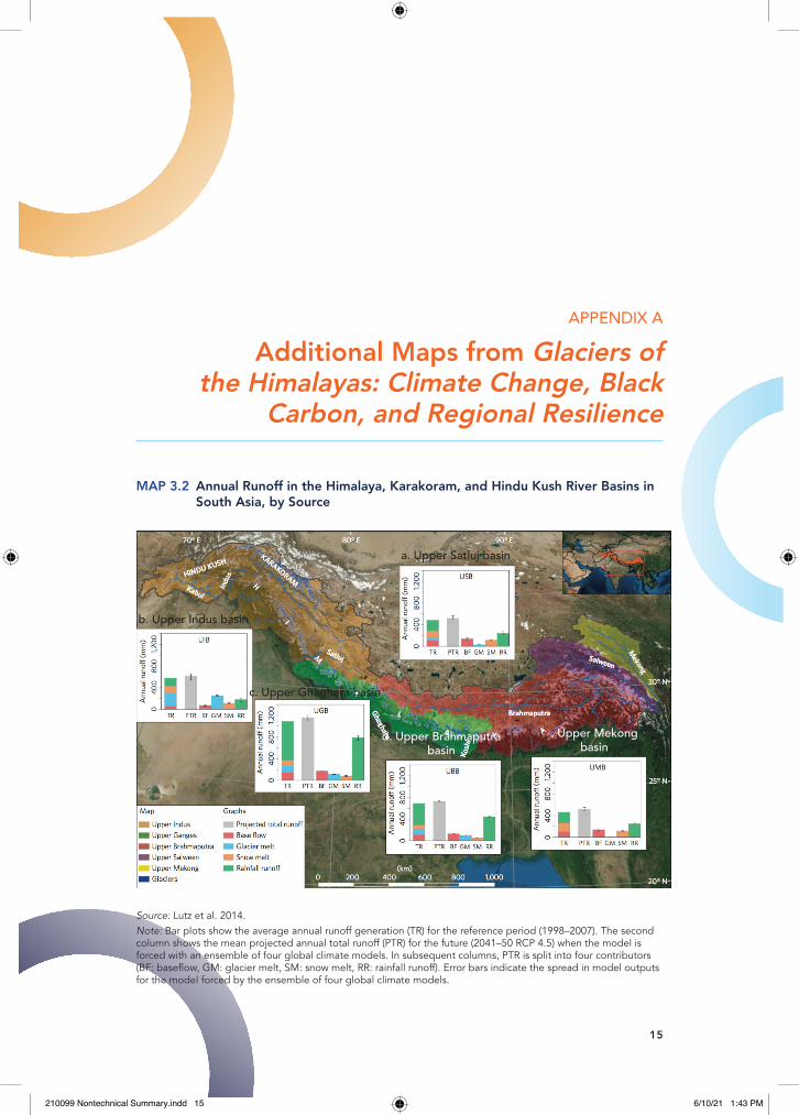
Source: lutz et al. 2014.Note: Bar plots show the average annual runoff generation (tr) for the reference period (1998–2007). the second column shows the mean projected annual total runoff (Ptr) for the future (2041–50 rcP 4.5) when the model is forced with an ensemble of four global climate models. in subsequent columns, Ptr is split into four contributors (Bf: baseflow, Gm: glacier melt, sm: snow melt, rr: rainfall runoff). error bars indicate the spread in model outputs for the model forced by the ensemble of four global climate models.
MAP 3.2 Annual Runoff in the Himalaya, Karakoram, and Hindu Kush River Basins in South Asia, by Source
a. Upper Satluj basin
b. Upper Indus basin
c. Upper Ghaghara basin
d. Upper Brahmaputrabasin
. Upper Mekongbasin
210099 Nontechnical Summary.indd 15 6/10/21 1:43 PM

16 l Glaciers of the himalayas
MAP 5.1 Black Carbon Emissions in Regions Adjacent to the Himalaya, Karakoram, and Hindu Kush Region, 2005
Source: adapted from Gertler et al. 2016.Note: the chart shows particularly large emissions along the Gangetic plain, which can be swept into the himalaya, Karakoram, and hindu Kush region seasonally by monsoon systems. Bc = black carbon. rcP = representative concentration pathway. units are Bc emissions (kgm−2s−1).
210099 Nontechnical Summary.indd 16 6/10/21 1:43 PM

aDDitioNal maPs from Glaciers of the himalayas l 17
MAP 5.2 A Modeling Domain for Air Pollution Covering Most of South Asia, Including High-Altitude Portions of the Tibetan Plateau
Source: original map created for this publication, based on publicly available climate data sets. Note: this map displays the Weather research and forecasting 2-meter surface temperature (K) on april 27 at 08:30 Z (13:30 local sidereal time) on the native 12-kilometer grid. the high-altitude portions of the tibetan plateau are colored blue-green.
210099 Nontechnical Summary.indd 17 6/10/21 1:43 PM

18 l Glaciers of the himalayas
Source: Based on data from the hadley centre for climate Prediction and research regional climate model (hadrm3P).
MAP 6.1 Water Production in the Upper Ganges and Upper Brahmaputra Basins
210099 Nontechnical Summary.indd 18 6/10/21 1:43 PM

Source: Based on data from the hadley centre for climate Prediction and research regional climate model (hadrm3P).Note: Dashes indicate that differences are smaller than 95% confidence intervals.
MAP 6.2 Difference between the RCP 4.5 (Standard) Average Temperature for 2030–59 and the Historic Long-Term Average Temperature in the Himalaya, Karakoram, and Hindu Kush Region
aDDitioNal maPs from Glaciers of the himalayas l 19
210099 Nontechnical Summary.indd 19 6/10/21 1:43 PM

20 l Glaciers of the himalayas
Source: Based on data from the hadley centre for climate Prediction and research regional climate model (hadrm3P).Note: Dashes indicate that differences are smaller than 95% confidence intervals.
MAP 6.3 Average Temperature and Precipitation in the RCP 4.5 (Mitigation) and RCP 4.5 (Standard) Scenarios in the Himalaya, Karakoram, and Hindu Kush Region, 2030–59
210099 Nontechnical Summary.indd 20 6/10/21 1:43 PM

Source: Based on data from the hadley centre for climate Prediction and research regional climate model (hadrm3P).
MAP 6.4 Total Water Runoff, Rainfall Runoff, and Water Released from Snow Melt and Ice Melt in the Himalaya, Karakoram, and Hindu Kush Region, from the Six Global Climate Models
Source: Based on data from the hadley centre for climate Prediction and research regional climate model (hadrm3P).
MAP 6.5 Variations in the Decadal Average Projections of Total Water Runoff, Rainfall Runoff, and Water Released from Snow Melt and Ice Melt: RCP 4.5 (Mitigation) Scenario
aDDitioNal maPs from Glaciers of the himalayas l 21
210099 Nontechnical Summary.indd 21 6/10/21 1:43 PM

22 l Glaciers of the himalayas
Source: Based on Winsemius et al. 2015.Note: Winsemius et al. (2015) use hydrological data for 1960–99 to generate flood inundations for the 10 years of a flood-return period. the estimation follows the baseline socioeconomic and hydrological scenarios. the light blue line denotes the indus, Ganges, and Brahmaputra basins. the dark blue line denotes 2,000 meters of altitude in the himalaya, Karakoram, and hindu Kush region.
MAP E.1 Estimated Number of Flood-Affected Population (Millions), by Basin, 2010
210099 Nontechnical Summary.indd 22 6/10/21 1:43 PM

MAP E.2 Historical Mean Indicators of Glacier Melt and Estimated Flood-Affected Population in South Asia
Source: Based on Winsemius et al. 2015.Note: Winsemius et al. (2015) use hydrological data for 1960–99 to generate flood inundations for the 10 years of a flood-return period. the overlay presents the simulation results. the estimation follows the baseline socioeconomic and hydrologic scenarios. the light blue line denotes the indus, Ganges, and Brahmaputra basins. the dark blue line denotes 2,000 meters of altitude in the himalaya, Karakoram, and hindu Kush region.
aDDitioNal maPs from Glaciers of the himalayas l 23
210099 Nontechnical Summary.indd 23 6/10/21 1:43 PM

210099 Nontechnical Summary.indd 24 6/10/21 1:43 PM