Gisburn forest and stocks A683 A6068 - Web Design km (0.25 miles) If you like your downhill bike...
2
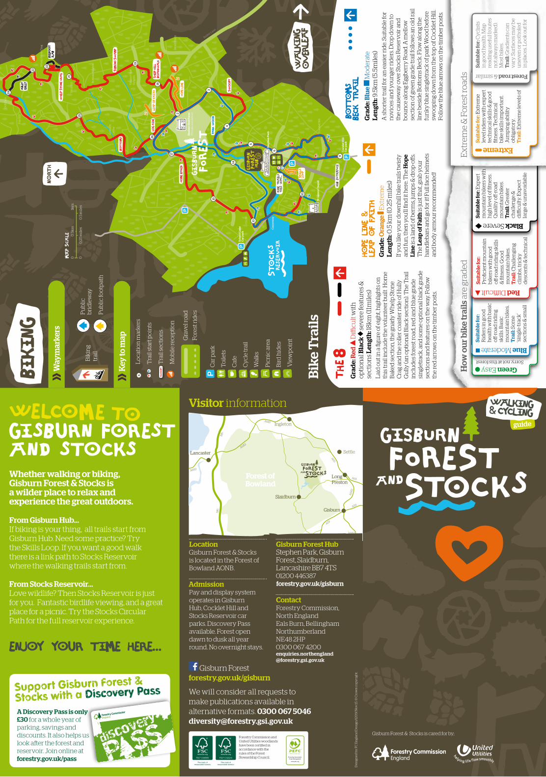
13 14 15 17 26 25 24 23 22 21 19 18 2 3 4 10 9 6 5 St James Chapel School Lane Car park Cocklet Hill Car park Stephen Park Cocklet Hill Dob Dale Fair Hill Whelp Stone Crag Herd Hill Bottom Heights Hesbert Hall Heights Geldard Laithe Heath Farm Circle Hesbert Hall Farm (Private residence) School Lane Bailey Lane Egg Berry Road Causeway Bigfoot slab Whelp Stone Crag Simons Swamp Log Ride Home Baked Park Wood Swoopy Hope Line Skills LoOP Ride trails this way... HuB ENTRANCE Sheep Hill Boardwalk Leap of Faith Bottoms Hully Gully Bottoms Beck Trail Grade: Blue Moderate Length: 9.5km (5.5miles) A shorter trail for an easier ride. Suitable for novices and younger riders. Drop down to the causeway over Stocks Reservoir and bounce along Eggberry Road. A mellow section of green grade trail follows an old rail line beside Bottoms Beck. Flow along the funky blue singletrack of park Wood before swooping down from the top of Cocklet Hill. Follow the blue arrows on the timber posts. Grade: Red Difficult with optional Black severe features & sections Length: 18km (11miles) Laid out in a figure of eight, highlights on this trail include the volunteer built Home Baked section, the gnarly Whelp Stone Crag and the roller coaster ride of Hully Gully (an optional Black section). The Trail includes forest road, red and blue grade singletrack, and some optional black grade sections and features on the way. Follow the red arrows on the timber posts. Hope Line & Leap of Faith Grade: Orange Extreme Length: 0.5 km (0.25 miles) If you like your downhill bike trails twisty and fun, then you’ll find it here. The Hope Line is a land of berms, jumps & drop-offs. The Leap of Faith is just that, grab your handlebars and go for it! Full face helmets and body armour recommended! How our bike trails are graded Green Easy Sorry, not at this forest Suitable for: Riders in good health with basic off-road riding skills. Basic mountain bikes. Trail: Some ‘single-track’ sections & small Blue Moderate Red Difficult Suitable for: Proficient mountain bikers with good off-road riding skills & fitness. Good mountain bikes. Trail: Challenging climbs, tricky descents & technical Black Severe Suitable for: Expert mountain bikers with high level of fitness. Quality off-road mountain bikes. Trail: Greater challenge & difficulty. Expect large & unavoidable Extreme Suitable for: Extreme level riders with expert technical skills & good fitness. Technical bike skills important. Jumping ability obligatory. Trail: Extreme levels of Extreme & Forest roads Suitable for: Cyclists in good health. Map reading useful (routes not always marked). Most bikes. Trail: Gradients can vary. Surfaces may be uneven or potholed in places. Look out for Forest road & similar Lancaster Lancaster Long Preston Long Preston Gisburn Gisburn Slaidburn Slaidburn A682 A59 A682 A59 A65 A65 A687 A683 A683 M6 M6 Forest of Bowland Forest of Bowland Ingleton Settle We will consider all requests to make publications available in alternative formats. 0300 067 5046 [email protected] Designed by FC England Design/1209/Nov 15. © Crown copyright. FSC® C123214 FSC® C005555 Forestry Commission and United Utilities woodlands have been certified in accordance with the rules of the Forest Stewardship Council. Visitor information Location Gisburn Forest & Stocks is located in the Forest of Bowland AONB. Admission Pay and display system operates in Gisburn Hub, Cocklet Hill and Stocks Reservoir car parks. Discovery Pass available. Forest open dawn to dusk all year round. No overnight stays. Gisburn Forest Hub Stephen Park, Gisburn Forest, Slaidburn, Lancashire BB7 4TS 01200 446387 forestry.gov.uk/gisburn Contact Forestry Commission, North England Eals Burn, Bellingham Northumberland NE48 2HP 0300 067 4200 enquiries.northengland @forestry.gsi.gov.uk north biking Biking trail Public bridleway Public footpath Waymarkers Car park Toilets Cafe Cycle trail Walks Picnic area Bird hides Viewpoint Gravel road Forest rides 6 Location markers Trail start points Swoopy Trail sections Mobile reception Key to map 0 1km 0.5km 0.5 miles 0.25 miles 0 MAP Scale Bike Trails guide Walking & Cycling Gisburn Forest & Stocks is cared for by; Walking overleaf Support Gisburn Forest & Stocks with a Discovery Pass A Discovery Pass is only £30 for a whole year of parking, savings and discounts. It also helps us look aſter the forest and reservoir. Join online at forestry.gov.uk/pass Whether walking or biking, Gisburn Forest & Stocks is a wilder place to relax and experience the great outdoors. From Gisburn Hub... If biking is your thing, all trails start from Gisburn Hub. Need some practice? Try the Skills Loop. If you want a good walk there is a link path to Stocks Reservoir where the walking trails start from. From Stocks Reservoir... Love wildlife? Then Stocks Reservoir is just for you. Fantastic birdlife viewing, and a great place for a picnic. Try the Stocks Circular Path for the full reservoir experience. Enjoy your time here... Welcome Gisburn forest and stocks to Gisburn Forest forestry.gov.uk/gisburn
Transcript of Gisburn forest and stocks A683 A6068 - Web Design km (0.25 miles) If you like your downhill bike...
13
14
15
17
26
25
24
23
22
21
19
18
2
3
4
10
9
6
5
St J
ames
Ch
apel
Sch
oo
l Lan
eC
ar p
ark
Co
ckle
t Hil
lC
ar p
ark
Step
hen
Par
k Co
ckle
t Hil
l
Do
b D
ale
Fai
r Hil
l
Wh
elp
Sto
ne
Cra
g
Her
d H
ill B
ott
om
Hei
ghts
Hes
ber
t Hal
l H
eigh
ts
Gel
dar
d
Lai
the
Hea
th F
arm
Cir
cle
Hes
ber
t Hal
l Far
m(P
riv
ate
resi
den
ce)
School Lane
Bailey Lane
Egg Berry R
oad
Cau
sew
ay
Bigfo
ot
sla
b
Whelp Stone Crag
Simons Swamp
Log Ride
Home Baked
Park W
ood
Swoopy
Hope Line
Skills
LoOP
Ride trails
this way...
HuB EN
TRANCE
Sheep Hill
Boardwalk
Lea
p of Fa
ith
Bottoms
Hully
Gully
Bottoms
Beck Trail
Gra
de:
Blu
e
Mo
der
ate
Len
gth
: 9.5
km
(5.5
mile
s)A
sh
ort
er tr
ail f
or a
n e
asie
r rid
e. S
uit
able
for
nov
ices
an
d y
ou
nge
r rid
ers.
Dro
p d
own
to
the
cau
sew
ay o
ver S
tock
s R
eser
voir
an
d
bo
un
ce a
lon
g E
ggb
erry
Ro
ad. A
mel
low
se
ctio
n o
f gre
en g
rad
e tr
ail f
ollo
ws
an o
ld ra
il lin
e b
esid
e B
ott
om
s B
eck.
Flo
w a
lon
g th
e fu
nky
blu
e si
ngl
etra
ck o
f par
k W
oo
d b
efo
re
swo
op
ing
dow
n fr
om
the
top
of C
ock
let H
ill.
Follo
w th
e b
lue
arro
ws
on
the
tim
ber
po
sts.
Gra
de:
Red
D
ifficu
lt w
ith
o
pti
on
al B
lack
s
ever
e fe
atu
res
&
sect
ion
s Le
ngt
h: 1
8k
m (1
1mile
s)L
aid
ou
t in
a fi
gure
of e
igh
t, h
igh
ligh
ts o
n
this
trai
l in
clu
de
the
volu
nte
er b
uilt
Ho
me
Bak
ed s
ecti
on
, th
e gn
arly
Wh
elp
Sto
ne
Cra
g an
d th
e ro
ller c
oas
ter r
ide
of H
ully
G
ully
(an
op
tio
nal
Bla
ck s
ecti
on
). T
he
Tra
il in
clu
des
fore
st ro
ad, r
ed a
nd
blu
e gr
ade
sin
glet
rack
, an
d s
om
e o
pti
on
al b
lack
gra
de
sect
ion
s an
d fe
atu
res
on
the
way
. Fo
llow
th
e re
d a
rrow
s o
n th
e ti
mb
er p
ost
s.
Hope Line &
Leap of Fa
ith
Gra
de:
Ora
nge
E
xtr
eme
Len
gth
: 0.5
km
(0.2
5 m
iles)
If y
ou
like
yo
ur d
own
hill
bik
e tr
ails
twis
ty
and
fun
, th
en y
ou
’ll fi
nd
it h
ere.
Th
e H
ope
Lin
e is
a la
nd
of b
erm
s, ju
mp
s &
dro
p-o
ffs.
Th
e Le
ap o
f Fai
th is
just
that
, gra
b y
ou
r h
and
leb
ars
and
go
for i
t! Fu
ll fa
ce h
elm
ets
and
bo
dy
arm
ou
r rec
om
men
ded
!
How
ou
r bik
e tr
ails
are
gra
ded
Green Easy Sorry, not at this forest
Suit
able
for:
R
ider
s in
go
od
h
ealt
h w
ith
bas
ic
off
-ro
ad r
idin
g sk
ills
. Bas
ic
mo
un
tain
bik
es.
Tra
il: S
om
e ‘s
ingl
e-t
rack
’ se
ctio
ns
& s
mal
l
Blue Moderate
Red Difficult Su
itab
le fo
r:
Pro
ficie
nt m
ou
nta
in
bik
ers
wit
h g
oo
d
off
-ro
ad ri
din
g sk
ills
& fi
tnes
s. G
oo
d
mo
un
tain
bik
es.
Tra
il: C
hal
len
gin
g cl
imb
s, tr
ick
y
des
cen
ts &
tech
nic
al
Black Severe
Suit
able
for:
Ex
per
t m
ou
nta
in b
iker
s w
ith
h
igh
lev
el o
f fitn
ess.
Q
ual
ity
off
-ro
ad
mo
un
tain
bik
es.
Tra
il: G
reat
er
chal
len
ge &
d
ifficu
lty.
Ex
pec
t la
rge
& u
nav
oid
able
Extreme
Suit
able
for:
Ex
trem
e le
vel
rid
ers
wit
h e
xp
ert
tech
nic
al s
kil
ls &
go
od
fit
nes
s. T
ech
nic
al
bik
e sk
ills
imp
ort
ant.
Jum
pin
g ab
ilit
y
ob
liga
tory
. T
rail
: Ex
trem
e le
vel
s o
f
Ex
trem
e &
Fo
rest
road
s
Suit
able
for:
Cyc
lists
in
go
od
hea
lth
. Map
re
adin
g u
sefu
l (ro
ute
s n
ot a
lway
s m
arke
d).
Mo
st b
ikes
. T
rail
: Gra
die
nts
can
v
ary.
Su
rfac
es m
ay b
e u
nev
en o
r po
tho
led
in
pla
ces.
Lo
ok
ou
t fo
r
Forest road & similar
LancasterLancaster
Long PrestonLong Preston
GisburnGisburn
SlaidburnSlaidburn
A68
2
A59
A56
A6068
A682
A59
A65
A65
A687
A683
A683
M6
M6
M6
Forest ofBowlandForest ofBowland
Ingleton
Settle
We will consider all requests to make publications available in alternative formats. 0300 067 5046 [email protected]
De
sign
ed
by
FC
En
glan
d D
esi
gn/1
209
/No
v 15
. © C
row
n c
op
yri
ght.
FSC® C123214FSC® C005555
Forestry Commission and United Utilities woodlands have been certi�ed in accordance with the rules of the Forest Stewardship Council.
Visitor information
LocationGisburn Forest & Stocks is located in the Forest of Bowland AONB. AdmissionPay and display system operates in Gisburn Hub, Cocklet Hill and Stocks Reservoir car parks. Discovery Pass available. Forest open dawn to dusk all year round. No overnight stays.
Gisburn Forest Hub Stephen Park, Gisburn Forest, Slaidburn, Lancashire BB7 4TS01200 446387forestry.gov.uk/gisburn
ContactForestry Commission,North England Eals Burn, BellinghamNorthumberland NE48 2HP0300 067 4200enquiries.northengland @forestry.gsi.gov.uk
north
biking
Bik
ing
trai
l
Pu
blic
b
rid
lew
ay
Pu
blic
foo
tpat
h
Way
mar
kers
Car
par
k
To
ilets
Caf
e
Cyc
le tr
ail
Wal
ks
Pic
nic
are
a
Bir
d h
ides
Vie
wp
oin
tGra
vel r
oad
Fore
st ri
des
6
Lo
cati
on
mar
kers
T
rail
star
t po
ints
Swoopy
Tra
il se
ctio
ns
M
ob
ile re
cep
tio
n
Key
to m
ap
01k
m0
.5k
m
0.5
mil
es
0.2
5 m
ile
s0MAP Scale
Bik
e T
rail
s
guide
Walking & Cycling
Gisburn Forest & Stocks is cared for by;
Walking
overleaf
Support Gisburn Forest &
Stocks with a Discovery Pass
A Discovery Pass is only £30 for a whole year of parking, savings and discounts. It also helps us look after the forest and reservoir. Join online at forestry.gov.uk/pass
Whether walking or biking, Gisburn Forest & Stocks is a wilder place to relax and experience the great outdoors.
From Gisburn Hub...If biking is your thing, all trails start from Gisburn Hub. Need some practice? Try the Skills Loop. If you want a good walk there is a link path to Stocks Reservoir where the walking trails start from.
From Stocks Reservoir...Love wildlife? Then Stocks Reservoir is just for you. Fantastic birdlife viewing, and a great place for a picnic. Try the Stocks Circular Path for the full reservoir experience.
Enjoy your time here...
WelcomeGisburn forest and stocks
to
Gisburn Forestforestry.gov.uk/gisburn
Rushton Hill
Ten Acre Hill
Black House
Hollins House
Board House
Fishing Lodge
New House Hasgill Beck
To
Cla
ph
am
Treatment Works
No public
vehicle access
Eak Hill
Footbridge
Hesbert Hall Farm(Private residence)
Bailey Lane
Dalehead Chapel and Heritage Centre
Stocks Reservoir Car park
Stephen Park
Cocklet Hill
Dob Dale
Fair Hill
Whelp Stone Crag
Herd Hill
Bottom Heights
Hesbert Hall Heights
Bottoms Beck
Geldard Laithe
Heath Farm
School Lane
Egg Berry Road
Causeway
To Slaid
burn
To B
enth
am
Car park
Toilets
Cafe
Cycle trail
Walks
Picnic area
Bird hides
Viewpoint
Gravel road
Forest rides
Key to map
Biking trail
Permissive footpath
Public footpath
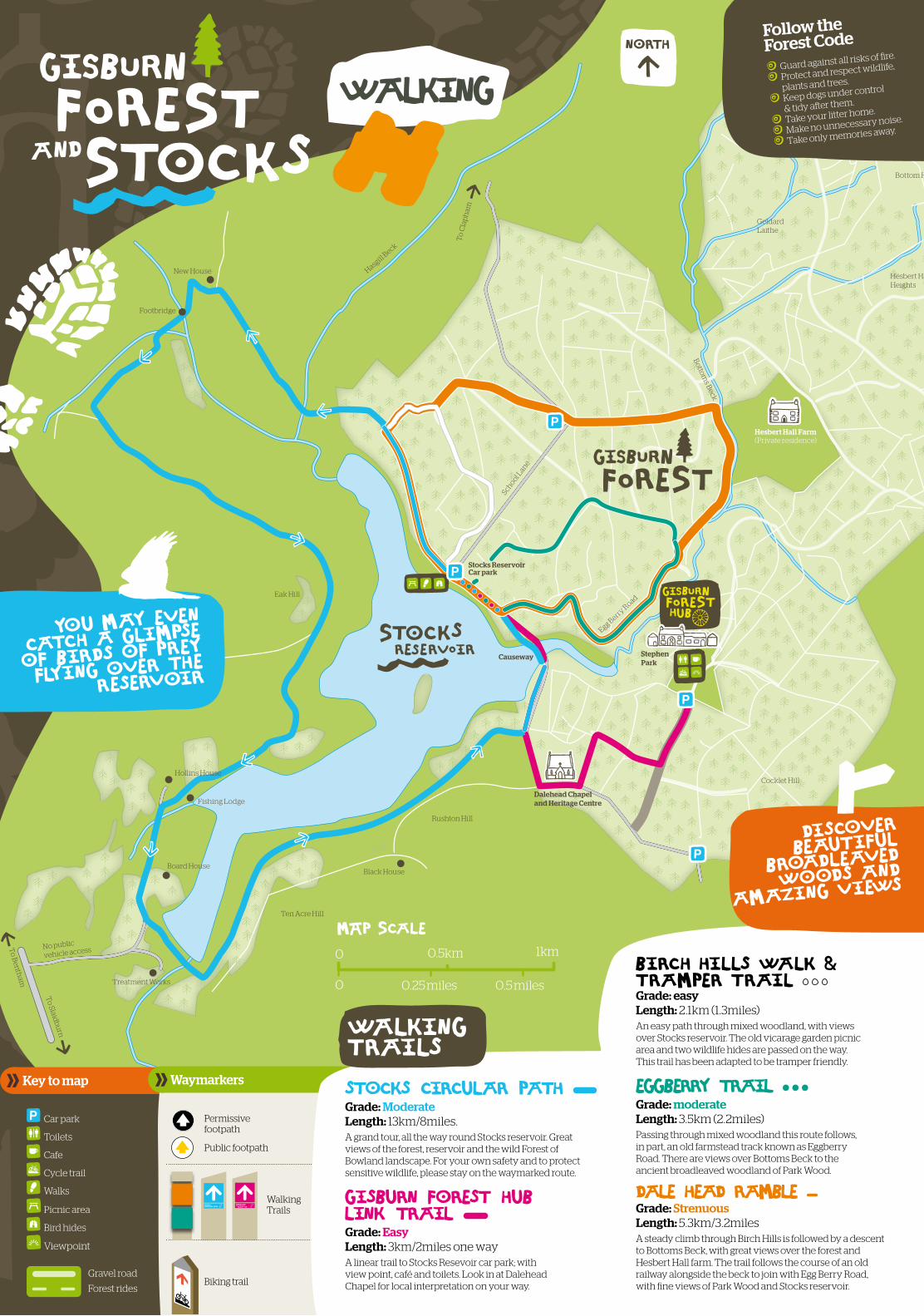
Walking Trails
Waymarkers
north
Walking trails
stocks circular path Grade: Moderate Length: 13km/8miles.A grand tour, all the way round Stocks reservoir. Great views of the forest, reservoir and the wild Forest of Bowland landscape. For your own safety and to protect sensitive wildlife, please stay on the waymarked route.
GIsburn Forest hub Link trail Grade: Easy Length: 3km/2miles one wayA linear trail to Stocks Resevoir car park; with view point, café and toilets. Look in at Dalehead Chapel for local interpretation on your way.
Birch Hills walk & tramper trail Grade: easy Length: 2.1km (1.3miles)An easy path through mixed woodland, with views over Stocks reservoir. The old vicarage garden picnic area and two wildlife hides are passed on the way. This trail has been adapted to be tramper friendly.
EggBerry trail Grade: moderate Length: 3.5km (2.2miles)Passing through mixed woodland this route follows, in part, an old farmstead track known as Eggberry Road. There are views over Bottoms Beck to the ancient broadleaved woodland of Park Wood.
Dale Head Ramble Grade: Strenuous Length: 5.3km/3.2milesA steady climb through Birch Hills is followed by a descent to Bottoms Beck, with great views over the forest and Hesbert Hall farm. The trail follows the course of an old railway alongside the beck to join with Egg Berry Road, with fine views of Park Wood and Stocks reservoir.
0 1km0.5km
0.5 miles0.25 miles0
MAP Scale
discover
beautiful
broadleaved
woods and
amazing views
Follow the Forest Code
You may even
catch a glimpse
of birds of prey
flying over the
reservoir
Guard against all risks of fire.
Protect and respect wildlife,
plants and trees.
Keep dogs under control
& tidy after them.
Take your litter home.
Make no unnecessary noise.
Take only memories away.
Walking