GIS Training Opportunity with National Geospatial ...geospatial intelligence, or GEOINT, for the...
19
1 1 GIS Training Opportunity with National Geospatial Intelligence Agency (NGA) College Laura Muhs, EVBL GIS PM NAVFAC HQ October 2018
Transcript of GIS Training Opportunity with National Geospatial ...geospatial intelligence, or GEOINT, for the...
1 1
GIS Training Opportunity with
National Geospatial
Intelligence Agency (NGA)
College
Laura Muhs, EVBL GIS PM
NAVFAC HQ
October 2018

2 2
National Geospatial-Intelligence Agency
(NGA)
• NGA is the nation's primary source of geospatial intelligence, or GEOINT, for the Department of Defense and the U.S. Intelligence Community.
• NGA provides GEOINT in support of U.S. national security and defense, as well as disaster relief.
• GEOINT is the exploitation and analysis of imagery and geospatial information that describes, assesses and visually depicts physical features and geographically referenced activities on the Earth.
• NGA College (NGC) was established to “enable access to the highest-quality learning experts, tools, and solutions for the GEOINT enterprise.”
• NGC’s teaching strategy is 30% lecture and 70% guided/practical exercises.
https://www.nga.mil/Pages/Default.aspx

3 3
NGA - GIS Training Options
NGC Classroom Training -
Dedicated computer lab classrooms at the
NGA HQs (in Springfield, VA or St. Louis,
MO) and Extended Learning Sites (in
Denver, CO; Honolulu, HI; and Tampa,
FL).
–Course offerings for all classes listed on
slide 4 available in October for upcoming
FY.
–See slides 6, 9, 11, 13, 15,17 and 18 for
class-specific schedules.
–Class availability is first come, first
served.
–Only cost to student is travel costs to
training location.
–Registration for non-NGA students is via
email to the NGC Registrar.
• Email: [email protected]
• Phone: 571-558-2968
Mobile Training Teams (MTTs) -
MTTs provide agency-specific training
opportunities throughout the country, per
agency request.
–Requesting agency responsible for
coordinating MTT.
–NGC provides laptops loaded with
software and exercises, and two (2)
instructors.
–Only cost to requesting agency is
student’s travel costs to training location.
–Only GIS 2101 is being offered at
NAVFAC-specific sites. See slide 7 for
MTT schedule.
–To register or request a MTT, contact
Laura Muhs, NAVFAC HQ at
[email protected] or 202-685-9128.
The NGC offers free classroom-based GIS courses to all Federal Government employees.

4 4
NGA - GIS Curriculum
• Fundamentals of GIS (GIS 2101)
– OR GIS Equivalency Testing (GIS 2111) (students may try and test out of GIS 2101)
–See slides 5, 6 & 7 for more information.
• Intermediate GIS for Analysis (GIS 3201)
–Pre-requisite is GIS 2101 or GIS 2111
–See slides 8 & 9 for more information.
• Geodatabase Design and Maintenance (GIS 3301)
–Pre-requisite is GIS 2101 or GIS 2111
–See slides 10 & 11 for more information.
• Advanced GIS using Models (GIS 4401)
–Pre-requisite is GIS 3201
–See slides 12 & 13 for more information.
• Advanced GIS using Scripts (GIS 4411)
–Pre-requisite is GIS 3201
–See slides 14 & 15 for more information.
• Geospatial Thinking (CRTH 2130)
–CRTH 2130 is not part of the NGC GIS curriculum for learning how to use the ArcGIS
software.
–See slides 16 & 17 for more information.
All NGA GIS courses must
be taken in sequential
order. However, NGA
offers an equivalency test
to test out of GIS 2101.
(See slide 18 for details.)
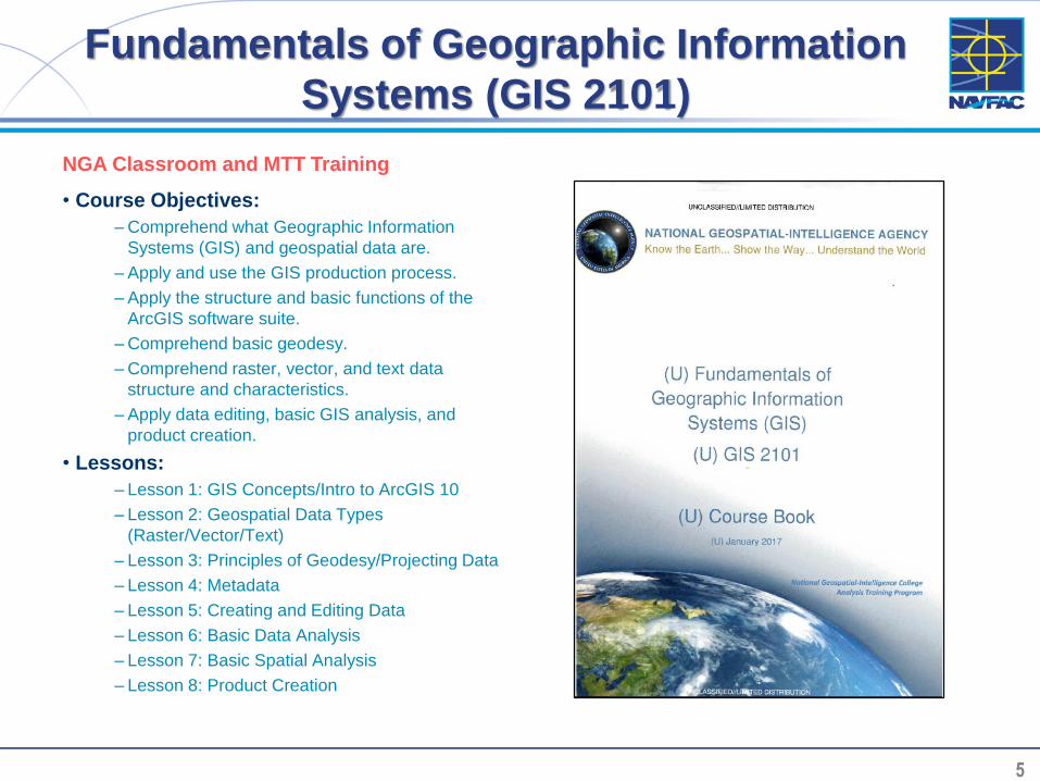
5 5
Fundamentals of Geographic Information
Systems (GIS 2101)
• Course Objectives:
– Comprehend what Geographic Information
Systems (GIS) and geospatial data are.
– Apply and use the GIS production process.
– Apply the structure and basic functions of the
ArcGIS software suite.
– Comprehend basic geodesy.
– Comprehend raster, vector, and text data
structure and characteristics.
– Apply data editing, basic GIS analysis, and
product creation.
• Lessons:
– Lesson 1: GIS Concepts/Intro to ArcGIS 10
– Lesson 2: Geospatial Data Types
(Raster/Vector/Text)
– Lesson 3: Principles of Geodesy/Projecting Data
– Lesson 4: Metadata
– Lesson 5: Creating and Editing Data
– Lesson 6: Basic Data Analysis
– Lesson 7: Basic Spatial Analysis
– Lesson 8: Product Creation
NGA Classroom and MTT Training

6 6
Fundamentals of Geographic Information
Systems (GIS 2101)NGA Classroom Course Offerings (FY19):• October 15-19, 2018 NGA College West (St. Louis, MO)
• October 15-19, 2018 NGA College East (Springfield, VA)
• October 29 – November 2, 2018 NGA College East (Springfield, VA)
• November 26-30, 2018 NGA College West (St. Louis, MO)
• November 26-30, 2018 NGA College East (Springfield, VA)
• November 26-30, 2018 ELS Honolulu
• December 3-7, 2018 ELS Molesworth (Adjunct)
• December 10-14, 2018 ELS Denver
• December 17-21, 2018 NGA College East (Springfield, VA)
• January 7-11, 2019 ELS Tampa
• January 7-11, 2019 NGA College West (St. Louis, MO)
• January 7-11, 2019 NGA College East (Springfield, VA)
• January 28 - February 1, 2019 NGA College East (Springfield, VA)
• February 11-15, 2019 ELS Honolulu
• February 25 – March 1, 2019 NGA College West (St. Louis, MO)
• February 25 – March 1, 2019 NGA College East (Springfield, VA)
• March 4-8, 2019 ELS Tampa
• March 25-29, 2019 NGA College East (Springfield, VA)
• March 25-29, 2019 ELS Honolulu
• April 8-12, 2019 NGA College East (Springfield, VA)
• April 29 – May 3, 2019 NGA College West (St. Louis, MO)
• April 29 – May 3, 2019 NGA College East (Springfield, VA)
• May 20-24, 2019 NGA College East (Springfield, VA)
• June 10-14, 2019 NGA College West (St. Louis, MO)
• June 10-14, 2019 NGA College East (Springfield, VA)
• July 8-12, 2019 NGA College East (Springfield, VA)
• July 22-26, 2019 NGA College West (St. Louis, MO)
• July 29 – August 2, 2019 NGA College East (Springfield, VA)
• August 19 -23, 2019 NGA College East (Springfield, VA)
• September 9-13, 2019 NGA College East (Springfield, VA)
• September 23-27, 2019 NGA College West (St. Louis, MO)
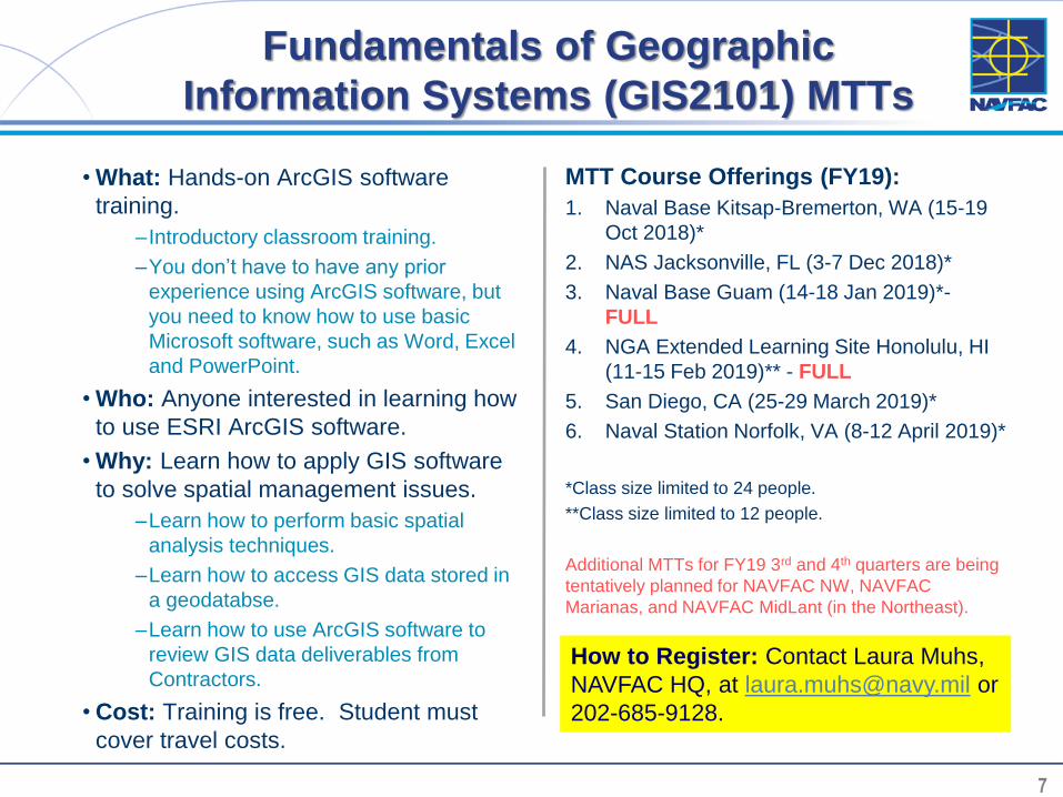
7 7
Fundamentals of Geographic
Information Systems (GIS2101) MTTs
• What: Hands-on ArcGIS software
training.
– Introductory classroom training.
–You don’t have to have any prior
experience using ArcGIS software, but
you need to know how to use basic
Microsoft software, such as Word, Excel
and PowerPoint.
• Who: Anyone interested in learning how
to use ESRI ArcGIS software.
• Why: Learn how to apply GIS software
to solve spatial management issues.
–Learn how to perform basic spatial
analysis techniques.
–Learn how to access GIS data stored in
a geodatabse.
–Learn how to use ArcGIS software to
review GIS data deliverables from
Contractors.
• Cost: Training is free. Student must
cover travel costs.
MTT Course Offerings (FY19):
1. Naval Base Kitsap-Bremerton, WA (15-19
Oct 2018)*
2. NAS Jacksonville, FL (3-7 Dec 2018)*
3. Naval Base Guam (14-18 Jan 2019)*-
FULL
4. NGA Extended Learning Site Honolulu, HI
(11-15 Feb 2019)** - FULL
5. San Diego, CA (25-29 March 2019)*
6. Naval Station Norfolk, VA (8-12 April 2019)*
*Class size limited to 24 people.
**Class size limited to 12 people.
Additional MTTs for FY19 3rd and 4th quarters are being
tentatively planned for NAVFAC NW, NAVFAC
Marianas, and NAVFAC MidLant (in the Northeast).
How to Register: Contact Laura Muhs,
NAVFAC HQ, at [email protected] or
202-685-9128.

8 8
Intermediate GIS for Analysis
(GIS 3201)
• Course Objectives:
– Prepare geospatial data for exploitation.
– Analyze geospatial problems using
intermediate-level analysis concepts, functions
and tools.
– Modify geoprocesses using intermediate-level
GIS utilities.
• Lessons:
– Lesson 1: Fundamentals Refresher
– Lesson 2: Managing Data with a Geodatabase
– Lesson 3: Geocoding
– Lesson 4: Geostatistical Analysis
– Lesson 5: Network Analysis
– Lesson 6: Raster Analysis
– Lesson 7: Introduction to Models
– Lesson 8: Introduction to Scripts
NGA Classroom Training

9 9
Intermediate GIS for Analysis
(GIS 3201)NGA Classroom Course Offerings (FY19):
• October 22-26, 2018 NCE College Classrooms (Springfield, VA)
• October 22-26, 2018 NCW-Building 36 (St. Louis, MO)
• December 3-7, 2018 ELS Honolulu
• December 3-7, 2018 NCE College Classrooms (Springfield, VA)
• January 14-18, 2019 NCW-Building 36 (St. Louis, MO)
• January 14-18, 2019 ELS Tampa
• February 4-8, 2019 ELS Molesworth (Adjunct)
• February 4-8, 2019 NCW-Building 36 (St. Louis, MO)
• February 4-8, 2019 NCE College Classrooms (Springfield, VA)
• February 4-8, 2019 NCE College Classrooms (Springfield, VA)
• February 25 – March 1, 2019 ELS Denver
• March 11-15, 2019 ELS Tampa
• March 25-29, 2019 NCE College Classrooms (Springfield, VA)
• April 1-5, 2019 NCW-Building 36 (St. Louis, MO)
• April 15-19, 2019 NCE College Classrooms (Springfield, VA)
• May 13-17, 2019 NCE College Classrooms (Springfield, VA)
• June 17-21, 2019 NCE College Classrooms (Springfield, VA)
• July 15-19, 2019 NCE College Classrooms (Springfield, VA)
• July 29 – August 2, 2019 NCW-Building 36 (St. Louis, MO)
• August 5-9, 2019 NCE College Classrooms (Springfield, VA)
• August 12-16, 2019 NCE College Classrooms (Springfield, VA)
• August 12-16, 2019 NCW-Building 36 (St. Louis, MO)
• September 16-20, 2019 NCE College Classrooms (Springfield, VA)

10 10
Geodatabase Design and Maintenance
Course (GIS 3301)
• Course Objectives:
– Develop basic data elements in a geodatabase.
– Employ advanced data elements in a
geodatabase.
– Manage a geodatabase using behaviors and
administrative techniques.
• Lessons:
– Lesson 1: The Geodatabase
– Lesson 2: Basic Elements
– Lesson 3: Domains & Subtypes
– Lesson 4: Topological Elements
– Lesson 5: Terrain Datasets
– Lesson 6: Cartographic Elements
– Lesson 7: Geodatabase Management
NGA Classroom Training

11 11
Geodatabase Design and
Maintenance Course (GIS 3301)
NGA Classroom Course Offerings (FY19):
• November 5-9, 2018 NCE College Classrooms (Springfield, VA)
• December 3-7, 2018 NCW-Building 36 (St. Louis, MO)
• February 11-15, 2019 NCW-Building 36 (St. Louis, MO)
• February 11-15, 2019 NCE College Classrooms (Springfield, VA)
• February 11-15, 2019 NCE College Classrooms (Springfield, VA)
• April 1-5, 2019 NCE College Classrooms (Springfield, VA)
• April 15-19, 2019 NCW-Building 36 (St. Louis, MO)
• May 6-10, 2019 NCE College Classrooms (Springfield, VA)
• May 20-24, 2019 NCE College Classrooms (Springfield, VA)
• July 22- 26, 2019 NCE College Classrooms (Springfield, VA)
• August 5-9, 2019 NCW-Building 36 (St. Louis, MO)
• August 19-23, 2019 NCE College Classrooms (Springfield, VA)
• August 19-23, 2019 NCW-Building 36(St. Louis, MO)

12 12
Advanced Geographic Information Systems
Using Models (GIS 4401)
• Course Objectives:
– Analyze and troubleshoot a model.
– Create a flowchart to apply to an analytical
problem.
– Create a model.
– Share an automated workflow.
• Lessons:
– Lesson 1: Flowcharting
– Lesson 2: Building a Model
– Lesson 3: Analyzing Models
– Lesson 4: Sharing an Automated Workflow
NGA Classroom Training
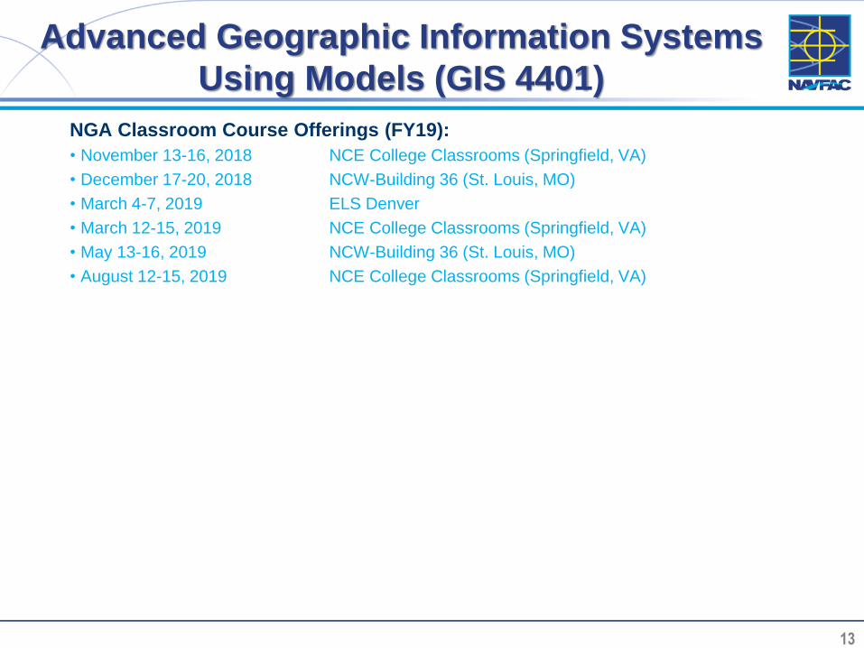
13 13
Advanced Geographic Information Systems
Using Models (GIS 4401)
NGA Classroom Course Offerings (FY19):
• November 13-16, 2018 NCE College Classrooms (Springfield, VA)
• December 17-20, 2018 NCW-Building 36 (St. Louis, MO)
• March 4-7, 2019 ELS Denver
• March 12-15, 2019 NCE College Classrooms (Springfield, VA)
• May 13-16, 2019 NCW-Building 36 (St. Louis, MO)
• August 12-15, 2019 NCE College Classrooms (Springfield, VA)
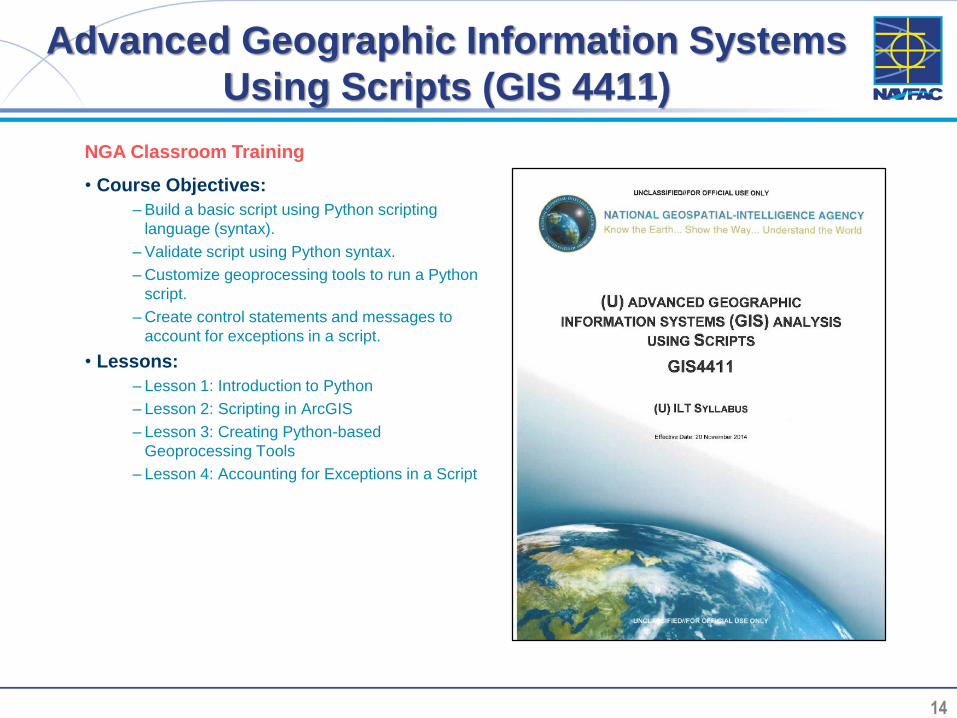
14 14
Advanced Geographic Information Systems
Using Scripts (GIS 4411)
• Course Objectives:
– Build a basic script using Python scripting
language (syntax).
– Validate script using Python syntax.
– Customize geoprocessing tools to run a Python
script.
– Create control statements and messages to
account for exceptions in a script.
• Lessons:
– Lesson 1: Introduction to Python
– Lesson 2: Scripting in ArcGIS
– Lesson 3: Creating Python-based
Geoprocessing Tools
– Lesson 4: Accounting for Exceptions in a Script
NGA Classroom Training

15 15
Advanced Geographic Information
Systems Using Scripts (GIS 4411)
NGA Classroom Course Offerings (FY19):
• September 17-21, 2018 NCE College Classrooms (Springfield, VA)
• September 24-28, 2018 NCW-Building 36 (St. Louis, MO)
• December 10-14, 2018 NCE College Classrooms (Springfield, VA)
• January 28 – February 1, 2019 NCW-Building 36 (St. Louis, MO)
• January 28 – February 1, 2019 ELS Tampa
• March 18-22, 2019 NCE College Classrooms (Springfield, VA)
• June 24-28, 2019 NCE College Classrooms (Springfield, VA)
• July 8-12, 2019 NCW-Building 36 (St. Louis, MO)
• September 23-27, 2019 NCE College Classrooms (Springfield, VA)

16 16
Geospatial Thinking
(CRTH 2130)
• Course Objectives:
– Describe the importance of spatial thinking to
GEOINT.
– Explain the relationship between GEOINT tolls
and spatial thinking.
– Define scientific methods.
– Discern spatial bias and spatial error in
GEOINT products.
– Deconstruct intelligence products using spatial
thinking techniques.
• Lessons:
– Lesson 1: The Concept of Space
– Lesson 2: Applying Tools of Representation to
Spatial Thinking
– Lesson 3: Using the Scientific Method to Solve
Spatial Problems
– Lesson 4: Spatial Thinking Biases and Pitfalls
Note: CRTH 2130 is not part of the NGC GIS
curriculum for learning how to use the ArcGIS
software.
NGA Classroom Training
17 17
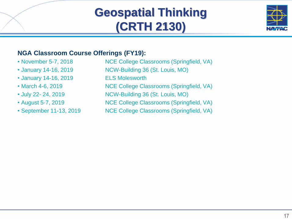
Geospatial Thinking
(CRTH 2130)
NGA Classroom Course Offerings (FY19):
• November 5-7, 2018 NCE College Classrooms (Springfield, VA)
• January 14-16, 2019 NCW-Building 36 (St. Louis, MO)
• January 14-16, 2019 ELS Molesworth
• March 4-6, 2019 NCE College Classrooms (Springfield, VA)
• July 22- 24, 2019 NCW-Building 36 (St. Louis, MO)
• August 5-7, 2019 NCE College Classrooms (Springfield, VA)
• September 11-13, 2019 NCE College Classrooms (Springfield, VA)
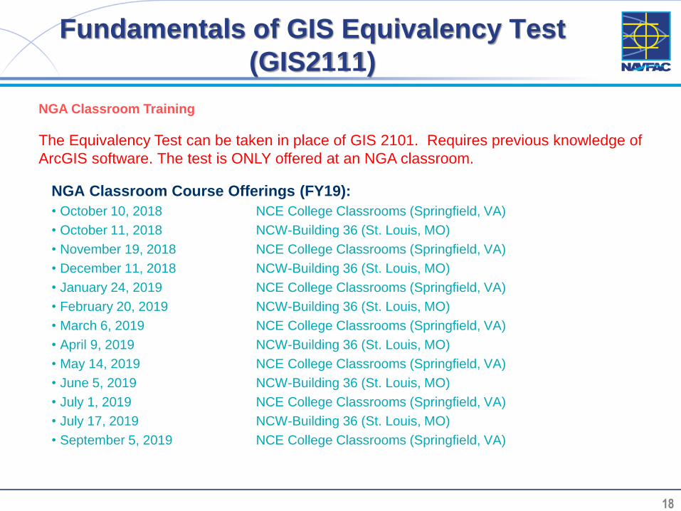
18 18
Fundamentals of GIS Equivalency Test
(GIS2111)
NGA Classroom Course Offerings (FY19):
• October 10, 2018 NCE College Classrooms (Springfield, VA)
• October 11, 2018 NCW-Building 36 (St. Louis, MO)
• November 19, 2018 NCE College Classrooms (Springfield, VA)
• December 11, 2018 NCW-Building 36 (St. Louis, MO)
• January 24, 2019 NCE College Classrooms (Springfield, VA)
• February 20, 2019 NCW-Building 36 (St. Louis, MO)
• March 6, 2019 NCE College Classrooms (Springfield, VA)
• April 9, 2019 NCW-Building 36 (St. Louis, MO)
• May 14, 2019 NCE College Classrooms (Springfield, VA)
• June 5, 2019 NCW-Building 36 (St. Louis, MO)
• July 1, 2019 NCE College Classrooms (Springfield, VA)
• July 17, 2019 NCW-Building 36 (St. Louis, MO)
• September 5, 2019 NCE College Classrooms (Springfield, VA)
The Equivalency Test can be taken in place of GIS 2101. Requires previous knowledge of
ArcGIS software. The test is ONLY offered at an NGA classroom.
NGA Classroom Training

19 19
FOR MORE INFORMATION
Contact Laura Muhs, NAVFAC HQ
202-685-9128