GIS Solutions for Retail - Esri/media/Files/Pdfs/library/...GIS Solutions for Retail ... for a...
12
GIS Solutions for Retail Understand Your Business From a New Perspective
Transcript of GIS Solutions for Retail - Esri/media/Files/Pdfs/library/...GIS Solutions for Retail ... for a...

GIS Solutions for RetailUnderstand Your Business From a New Perspective

GIS: Visualize, Analyze, and Leverage Your Data
ESRI gives business professionals better tools to visualize, analyze, and leverage their business data in order to improve efficiency and decision making.
GIS, a Tool That Means Business
Approximately 80 percent of all business data are related to loca-
tion. Businesses manage a world of information about sales, cus-
tomers, inventory, demographic profiles, mailing lists, and so much
more. No matter what industry you are in, business success means
making wiser decisions faster than your competition. Being able to
understand the market and obtain information quickly so you can
take fast action is key. The intuitive power of maps often reveals
trends, patterns, and opportunities that may not be detected in tabu-
lar data alone. Maps are the key to success in business.
GIS by ESRI™
Geographic information systems (GIS) software is a tool for making maps, analyzing data, and reporting your results. Since 1969, ESRI has been helping people solve real-world geographic and business problems. Today more than 100,000 organizations around the world use ESRI’s leading edge technology to manage location information. By visualizing their information, businesses and government agencies have a better way to organize and visualize their data for improved communications and enhanced decision making.
A GIS uses computers, software, and data to leverage the fun-damental principle of geography—that location is important to business. GIS takes the numbers and data from the rows and columns in databases and spreadsheets and puts them on a map. Placing your data on a map highlights where you have customers around your store locations and identifies what their demographic profile is. It allows you to view, understand, question, interpret, analyze, and visualize your data in ways simply not possible in rows and columns of a spreadsheet.
www.esri.com/retail

Advances in technology are rewriting the rules of the game in increasingly rapid cycles. ESRI believes that the future success of retail, real estate, and restaurants will be determined to a large degree by the competitive advantages of investing in and imple-menting smart technology. GIS is one of the smart technologies that will give you this competitive advantage. It is encouraging to see our users take the lead in implementing smart GIS technol-ogy on projects that will bring value to their organization and improve their bottom line. GIS adds spatial intelligence, the one true source of sustainable competitive advantage, to your organization.
In today’s fiercely competitive environment, retailers must use every advantage to acquire and retain customers, plan market expansion and contraction, locate profitable sites, stay abreast of changing consumer tastes, and act faster than the competi-tion. To help companies achieve these goals, ESRI believes in a basic principle that has guided our company for more than 30 years—Geography Matters™.
Geography fundamentally influences and connects culture, busi-ness, society, and lifestyle. Geography answers many business and marketing queries. We are committed to the idea that tools that leverage geography, such as GIS, are smart for business and should become as common in business as back-office account-ing systems. ESRI can help your company achieve even greater productivity through the implementation of these tools.
ESRI has the data, technology, Web services, and infrastructure to support retailers in the implementation of solutions that foster growth. We develop applications that will precisely mine customer information. ESRI Business Information Solutions (ESRI BIS™) demographic, segmentation, and third party data sets reveal trends and untapped opportunities, then integrate these sources into an enterprise platform consisting of mobile, desk-top, and Web services technology. Our solutions are affordable and scalable and reduce costs by enabling departments to share data and applications. IT departments will save time and increase productivity by maintaining a single software platform and one set of data. Our software technology also reaches across your organization to embed real-time, live transaction data stored in your data warehouses or just in a Microsoft® Access database. Our solutions grow as your business grows.
Part of our credo is that the human factor should figure promi-nently into every successful technology conversion. ESRI’s teams of dedicated experts carefully guide our clients through every stage of systems creation—from inspiration, invention, integra-tion, and implementation to a successful conclusion. We take great pride in fostering long-term relationships with our clients. Our staff members always go the extra mile to resolve issues, answer questions, or just be there for our clients. Your success is our success.

Map Your Way to Business Success!GIS can be applied to many aspects of retail business, here is a sample of some relevant business applications.
Delivery Routing/Fleet Management
Demographic Analysis
Trade Area Analysis
Site Selection
Real Estate/Store Development Applications
Demographic AnalysisDemographic analysis is the basis for many other business func-tions: customer service, site analysis, and marketing. Understand-ing your customers and their socioeconomic and purchasing behavior is essential to making good business decisions.
Trade Area AnalysisGeography is critical to the commercial real estate market. A less than optimal business location can make or break a business, no matter how good the service or product
Supply Chain Operations Applications
Delivery Routing/Fleet ManagementGIS integrates mapping analysis into decision support for everything from calculated arrival times to customer sites and schedule requests.
Competitive Market AnalysisLosing customers to the competition costs you money. Knowing the types of products, promotions, and services that will attract profitable customers in your trade area can help create customer loyalty and prevent cannibalization.
Site SelectionGIS can help you find the right site for your next store, distribution center, or service department. With GIS, you can blend customer surveys with census data to visualize market penetration, market share, and trade areas. When markets change, GIS can help you plan exit strategies and asset disposal.
Competitive Market Analysis

Facilities Management
Internet Store Locator
Marketing/Advertising
Target Marketing/Direct Mail
Marketing/Advertising Applications
Marketing/AdvertisingWhat works in Atlanta might not always work in Seattle. GIS market analysis tools can help you determine which products and promotions match the lifestyles and buying patterns of your cus-tomers. Create a multidimensional snapshot of trends to create trade areas, predict sales, design sales territories, plan media, and much more.
Target Marketing/Direct MailKnowing and understanding your customers’ likes and dislikes are integral to the success of a direct mail campaign. GIS enables you to identify who your most valuable customers are, under-stand their demographic characteristics, measure their direct mail response by product category or promotion, and target where new customers with similar demographic characteristics are located.
IT/IS Department Applications
Internet Store LocatorProspective customers visiting your Web site can display maps and get driving directions to your various store locations. Gain more flexibility in your Internet map publishing process.
Facilities Management Applications
Facilities ManagementFacilities management is the practice of coordinating the physical workplace with the people and work of an organization. Businesses know that it is vital to maintain a well-managed and efficient facility. GIS enhances the ability to provide current information and maps, locating facilities, such as conference rooms, restrooms, and emergency exits, within an organization.

Here’s How Geography Matters to Your Organization
IT/IS Department Real Estate/Store Development
Marketing/ Advertising
Merchandising
• Web-based store locator
• Manage spatial data
• Integrate with corporate databases
• Spatially enable all departments
• Facilitate spatial data sharing and exchange
• Enterprise mapping and analysis
• Evaluate sites
• Analyze your competition
• Profile customers
• Manage store portfolio
• Define traffic patterns
• Evaluate market potential
• Analyze trade areas
• Forecast and model sales
• Evaluate advertising effectiveness
• Focus advertising campaigns
• Define targets
• Analyze markets
• Develop target promo- tions and campaigns
• Geocode customers
• Understand customer spending
• Rank store locations by type and merchan- dise mix
• Analyze market demographics
• Evaluate cross sell and up sell opportunities
• Analyze trade area
• Segment customers by lifestyle and product category
• Model store customer databases
Peet’s Coffee & Tea, Inc., Utilizes RouteMAP IMS for Both Customers and Resellers
Peet’s Coffee & Tea, Inc., a specialty coffee roaster and marketer, utilizes ESRI® RouteMAP™ Internet Map Server (IMS) in conjunction with its commercial Web site at www.peets.com. “We were looking for a cost-effective solution that provides customers with fast and efficient directions,” says Melissa West, Webmaster at Peet’s Coffee & Tea. “We also wanted to be able to keep the content as fresh and up-to-date as possible. As Peet’s continues to expand its distribution through new retail locations and partnerships with grocery stores and food service outlets nationwide, it is important that our customers know how accessible and convenient it has become to find and buy our products. This program has worked out very well.”

Here’s How Geography Matters to Your Organization
Retail Operations Supply Chain Operations
Facilities Management
• District/Zone map changes
• Analyze markets
• Penetrate markets
• Profile customers
• Forecast market potential
• Score and predict consumer buying behavior
• Integrate in-store, catalog, and Internet market analyses
• Locate distribution centers (DC)
• Deliver and route from DC to store locations
• Reduce product cycle time
• Enable just-in-time scheduling
• Minimize overtime
• Schedule and manage your fleet
• Provide dispatcher summary reports
• Map headquarters
• Map departmental areas/zones
• Map and locate
- Restrooms
- Emergency exits
- Fire extinguishers
- Conference rooms
- Public telephones
- Stairs
- Elevators
- Parking
- Printers
- Copiers
Geography Matters to Coinstar
GIS is used for a vast array of business applications. Coinstar today maintains two GIS staff members who perform analyses for several departments across the enterprise including marketing research and analysis, retail account development (sales), coin services, field opera-tions, installations, and finance. “We’ve seen a number of benefits including more informed planning and decision making, optimized allo-cation of resources, and improved performance,” says Bill Gottlieb, Marketing Research & Metrics director at Coinstar. “GIS has proven itself over and over again as a technological tool for many facets of our business. It’s more than just computer mapping. It’s real data integration, analysis, and visualization.”

“There was a great deal of work involved in customiz-ing the site the way ExxonMobil wanted it. We per-formed extensive customization for the search criteria, since we wanted to give users a lot of flexibility based on the feedback we received. We looked at a number of solutions quite rigorously, and we really liked the ESRI software.”
Jack Brown, President, Web MarketingConsultant to ExxonMobil
ESRI® GIS solutions can help you make better decisions, save money, and provide better customer service. No other company offers a complete suite of software programs that meets the needs of all departments within your organiza-tion. ESRI has combined its GIS software with industry specific data and functionality to create a complete solu-tion for your business needs.
ArcGIS Business Analyst
ArcGIS® Business Analyst is a unique set of tools and data designed specifically for business applications. It allows you to analyze markets and customers, see trends and patterns on maps, and generate comprehensive demographic reports. The software has an easy-to-use wizard interface that guides you through complex business tasks. Because the data and analysis procedures are built in, you can focus on results rather than the details of the underlying technology.
Community Coder
This geocoding software appends geographic coordinates and data variables to each record in a cus-tomer file singly or in batch mode for more targeted messaging and better customer and prospect identification.
Portfolio
ESRI BIS Portfolio software combines the most current ESRI BIS data with Allocate data compression and/or Solocast segmenta-tion to help you run reports, make maps, build customer profiles, and perform other marketing applications right from your PC desktop.
The seamless integration of Allocate and Solocast software and data components permits them to be used together or separately.
ArcLogistics Route
ArcLogistics™ Route is a stand-alone end user application designed to solve vehicle routing and scheduling problems, enabling you to create and
manage sets of routes for your fleets of vehicles. Logistics professionals use ArcLogistics Route to geocode stops; optimize routes and schedules; and output maps, directions, and reports. ArcLogistics Route assigns customers to vehicles and determines the optimal stop sequences to minimize costs and honor time windows. Routes are built based on actual network drive times (not straight-line distances).
Business Software Solutions
MobileApplications
ArcPad®
ESRI BIS Data
DemographicsSegmentation
Consumer ExpenditureMarket Potential
Retail MarketPlaceBusiness
Shopping CenterTraffic Counts
CommunityInfo
Enterprise GISSoftware
ArcGIS
Business Analystfor the Enterprise
Tools forCustom Internet
Solutions
ArcIMS®
ArcSDE®
RouteMAP IMS
ArcWeb Services
Publications
Community Sourcebooks
ZIP CodeDemographics
CountyDemographics
OnlineSolutions
ArcWebSM Services
Business AnalystOnline
My BusinessAnalyst Online
Analytical Services
SegmentationAnalysis
Data Appending
Response Modeling
Customer Profiling
Mapping
Sales Forecasting
Address Geocoding
Site Scoring
DataDeliverables
DVDs
CDs
Online
Hard-Copy Reports
Desktop Toolsfor Business
Analysis
Portfolio
Allocate
Solocast
ArcGIS BusinessAnalyst
Community™ Coder
CommunitySourcebook•America™
With ArcReader™
YourData
Business AnalystWeb ServicesArcLogistics Route

The following industries benefit from ESRI BIS’ products, services, and solutions.
• Retail
• Real Estate
• Restaurants
• Media and Agencies
• Financial and Insurance
• Utilities and Telecommunications
• Health Care
• Nonprofits
• Entertainment
• Federal, State, and Local Government
ESRI BIS software and Web services solutions—from desk-top to enterprise—let you harness the power of accurate, comprehensive data for reports, maps, and analyses that solve your research and marketing needs.
Business Analyst Online
Access ESRI BIS data and mapping instantly from Business Analyst Online either à la carte or via flexible subscription plans. Interactive features, such as project saving, thematic mapping, hand drawn polygons, and presentation quality output, will increase your organization’s efficiencies.
My Business Analyst Online
My Business Analyst Online allows you the use of the ESRI BIS Web site data reporting and mapping capabilities customized with your organization’s look and feel to share across your organization.
Web Services
Use Business Analyst Web services to empower your desktop and Web applications with leading edge GIS technology and exten-sive business, demographic, and consumer household data.
RouteMAP IMS
RouteMAP™ IMS is an affordable out-of-the-box Internet map server that helps companies add mapping and routing capabilities to their Web
sites. RouteMAP IMS is software that resides on your server, allowing you to change, edit, and serve an unlimited number of maps and routes, while giving you total control of content and the user interface. RouteMAP IMS enables you to generate more business activity for your company by allowing prospective customers visiting your Web site to display maps and get driving directions to your various business locations.
Community Sourcebook•America With ArcReader
This CD–ROM combines demographic data from the Community Sourcebook of ZIP Code Demographics and the Community Sourcebook of County Demographics with proprietary query, sort, and report software. ESRI’s ArcReader software allows you to easily view, explore, display, and print maps.
Business Software Solutions
MobileApplications
ArcPad®
ESRI BIS Data
DemographicsSegmentation
Consumer ExpenditureMarket Potential
Retail MarketPlaceBusiness
Shopping CenterTraffic Counts
CommunityInfo
Enterprise GISSoftware
ArcGIS
Business Analystfor the Enterprise
Tools forCustom Internet
Solutions
ArcIMS®
ArcSDE®
RouteMAP IMS
ArcWeb Services
Publications
Community Sourcebooks
ZIP CodeDemographics
CountyDemographics
OnlineSolutions
ArcWebSM Services
Business AnalystOnline
My BusinessAnalyst Online
Analytical Services
SegmentationAnalysis
Data Appending
Response Modeling
Customer Profiling
Mapping
Sales Forecasting
Address Geocoding
Site Scoring
DataDeliverables
DVDs
CDs
Online
Hard-Copy Reports
Desktop Toolsfor Business
Analysis
Portfolio
Allocate
Solocast
ArcGIS BusinessAnalyst
Community™ Coder
CommunitySourcebook•America™
With ArcReader™
YourData
Business AnalystWeb ServicesArcLogistics Route

Data Packages
Industry specific data packages from ESRI BIS help businesses and agencies better understand their markets and constituencies.
CommunityInfo: CommunityInfo™-related data tables include current information about the people, workers, and spending patterns by community. Designed to help government agencies, organiza-tions, and businesses better understand their market area and constituencies, CommunityInfo’s nine industry specific packages are easily integrated into ArcGIS technology. CommunityInfo data is available for economic development, education, financial ser-vices, health and human services, homeland security, insurance, retail, restaurants, and census.
Sourcebooks: The ESRI BIS ZIP Code and county sourcebooks are the definitive demographic data reference tools used by companies, public agencies, universities, and public libraries for quick and easy demographic research. The Community Sourcebook of ZIP Code Demographics and the Community Sourcebook of County Demographics contain four pages of demographic data for every U.S. ZIP Code and county, respectively, arranged in an easy-to-read format along with methodology statements, maps, and other important reference information.
ESRI BIS Data The ESRI BIS team of expert data developers uses proven methodologies to carefully review and verify all data products. Users can depend on accurate and timely data updates and delivery from ESRI BIS. Data is available in a variety of deliv-erables including DVD, CD, hard-copy reports, printed books, and online. ESRI BIS data seamlessly integrates into software products and is available through project work, by license, and on the ESRI BIS Web site.
Databases
ESRI BIS provides an extensive range of data to fit the needs of users in any organization.
Demographics: ESRI BIS demographic data includes current-year estimates and five-year forecasts. For a complete list of the ESRI BIS demographic vari-ables, please refer to Electronic America, the online data catalog, at www.esribis.com/data.
Segmentation: The Community Tapestry™ segmentation system provides an accurate, detailed description of America’s neighborhoods. U.S. residential areas are divided into 65 segments based on their socioeconomic and demographic composition. With Tapestry you can profile consumers based on standard geo-graphic areas, user-defined areas, customer addresses, or site locations.
Consumer Expenditure: This comprehensive database, developed by ESRI BIS, is based on a combination of the latest Consumer Expenditure Surveys (CEX) from the Bureau of Labor Statistics. Data is reported by product or service and includes total expenditures, average spending per household, and a Spending Potential Index (SPI).
Market Potential: The ESRI BIS Market Potential database includes data for goods, services, attitudes, and activities collected from Mediamark Research, Inc. The database projects the expected number of consumers and provides Market Potential Indices (MPI).
Retail MarketPlace: This database enables businesses to analyze both supply (retail sales) and demand (consumer spending or retail potential) for retail trade and food services and drinking establishments. In addition, the leakage/surplus estimate in this database allows users to compare consumer spending by house-holds to retail sales by businesses and quickly analyze the potential of future sites.
Business: ESRI BIS’ business data is extracted from a comprehensive list of businesses licensed from infoUSA, Inc. The business list contains data on more than 11 million U.S. businesses including name and location, franchise code, industrial classification code, number of employees, and sales.
Shopping Center: ESRI BIS offers two options for shopping center informa-tion—National Research Bureau and Directory of Major Malls. The National Research Bureau (NRB) database provides accurate, complete, and current data for all shopping centers with three or more stores regardless of gross leasable area (GLA). The database includes more than 40,000 centers of every size and type. The Directory of Major Malls (DMM) database includes informa-tion about shopping centers with a GLA of 250,000 square feet or more.
Traffic Counts: ESRI BIS’ traffic count data comes from MPSI/DataMetrix and provides the most current and extensive U.S. traffic data for trade analysis, routing, or mathematical modeling.
www.esribis.com/data

ArcGIS
ArcGIS is used for the creation, management, inte-gration, analysis, display, and dissemination of spatial data. Strong visualization, editing, and
analysis, along with advanced data management, distinguish the ArcGIS software family as the leading GIS software.
Users can deploy multiple ArcGIS client (ArcView, ArcEditor, ArcInfo) seats, ArcGIS servers (ArcSDE and ArcIMS), and mobile technology (ArcPad) to meet their needs for scalable GIS solutions.
ArcView, ArcEditor, and ArcInfo
ArcView, ArcEditor, and ArcInfo are collectively known as ArcGIS Desktop. ArcGIS Desktop provides a scalable system for data visualization, query, analysis, and management along with the ability to create and edit geographic data.
ArcIMS
ArcIMS software is the foundation for distributing GIS data and applications on the Internet. By providing a common platform for exchanging and sharing GIS resources, ArcIMS provides unique opportunities to leverage data from within the organization and to integrate information from other agencies.
ArcSDE
ArcSDE is an application server that facilitates storing and man-aging spatial data in a relational database management system. ArcSDE allows you to openly manage spatial data in one of four commercial databases (IBM® DB2® and Informix®, Microsoft SQL Server™, and Oracle®) and to serve ESRI’s file-based data. ArcSDE plays a fundamental role in a multiuser GIS and delivers spatial data to desktop, Web-based, and mobile client applications.
ArcPad
ArcPad software is a mobile geographic information system technology. ArcPad provides database access, mapping, GIS, and global positioning system (GPS) integration out in the field via handheld and mobile devices. Data collection with ArcPad is fast and easy and significantly improved with immediate data valida-tion and availability.
ArcWeb Services
ArcWeb Services are ESRI’s family of hosted GIS Web services. They offer a way to provide GIS content and capabilities for your applications without having to host the data or develop the necessary tools. The result is significant savings of time, expense, and computer resources.
ESRI GIS Software ESRI offers a total range of software solutions for every company, from the one-person entrepreneur using a PC to the most advanced corporate enterprise environment. Used by more organizations than all other GIS software combined, ESRI is the world leader in GIS technology. The following ESRI software programs have been designed especially for business.
™
™
®
™
Australia www.esriaustralia.com.au
Belgium/Luxembourg www.esribelux.com
Bulgaria www.esribulgaria.com
Canada www.esricanada.com
China (Beijing) www.esrichina-bj.cn
China (Hong Kong) www.esrichina-hk.com
Finland www.esri-finland.com
France www.esrifrance.fr
Germany/Switzerland www.esri-germany.de
www.esri-suisse.ch
Hungary www.esrihu.hu
India www.esriindia.com
Indonesia/Malaysia 62-21-527-1023 603-7874-9930
Italy www.esriitalia.it
Japan www.esrij.com
Korea www.esrikr.co.kr
Netherlands www.esrinl.com
Poland www.gis.com.pl
Portugal www.esri-portugal.pt
Romania www.esriro.ro
Singapore www.esrisa.com
Spain www.esri-es.com
Sweden www.esri-sweden.com
Thailand www.esrith.com
United Kingdom www.esriuk.com
Venezuela www.esriven.com
No. GS-35F-5086H
Printed in USA96820INLD12M4/04sp
Copyright © 2004 ESRI. All rights reserved. ESRI, GIS by ESRI, ArcExplorer, the ArcGIS logo, Geography Matters, RouteMAP, ArcWeb, ArcView, ArcIMS, the ESRI globe logo, ArcInfo, ArcEditor, ArcSDE, ArcGIS, @esri.com, www.esri.com, ArcLogistics, the ArcLogistics Route logo, ArcReader, ArcPad, ArcMap, and the RouteMAP IMS logo are trademarks, registered trademarks, or service marks of ESRI in the United States, the European Community, or certain other jurisdictions. Other companies and products mentioned herein are trademarks or registered trademarks of their respective trademark owners.
Place ESRI business partner or distributor address here.
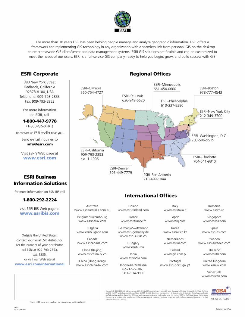
For more than 30 years ESRI has been helping people manage and analyze geographic information. ESRI offers a framework for implementing GIS technology in any organization with a seamless link from personal GIS on the desktop
to enterprisewide GIS client/server and data management systems. ESRI GIS solutions are flexible and can be customized to meet the needs of our users. ESRI is a full-service GIS company, ready to help you begin, grow, and build success with GIS.
International Offices
380 New York Street Redlands, California 92373-8100, USA
Telephone: 909-793-2853 Fax: 909-793-5953
For more information on ESRI, call
1-800-447-9778 (1-800-GIS-XPRT)
or contact an ESRI reseller near you.
Send e-mail inquiries to [email protected]
Visit ESRI’s Web page at www.esri.com
ESRI Corporate
Outside the United States,
contact your local ESRI distributor.
For the number of your distributor,
call ESRI at 909-793-2853,
ext. 1235,
or visit our Web site at www.esri.com/international
Regional Offices
ESRI–Minneapolis 651-454-0600ESRI–Olympia
360-754-4727ESRI–Boston 978-777-4543
ESRI–California 909-793-2853 ext. 1-1906
ESRI–Denver 303-449-7779
ESRI–San Antonio 210-499-1044
ESRI–Charlotte 704-541-9810
ESRI–Washington, D.C. 703-506-9515
ESRI–St. Louis 636-949-6620 ESRI–Philadelphia
610-337-8380
ESRI–New York City 212-349-3700
for more information on ESRI BIS,call
1-800-292-2224
visit ESRI BIS Web page at www.esribis.com
ESRI BusinessInformation Solutions