GIS Mapping of Gas Pipeline Distribution Network · GIS Mapping of Gas Pipeline Distribution...
14
GIS Mapping of Gas Pipeline Distribution Network Institute of Geology University of the Punjab, Pakistan www.pu.edu.pk Furqan Iqbal PhD Student at Punjab University, Pakistan Phone: 0470432323, +923344055563 Email: [email protected]
Transcript of GIS Mapping of Gas Pipeline Distribution Network · GIS Mapping of Gas Pipeline Distribution...

GIS Mapping of Gas Pipeline Distribution Network
Institute of Geology
University of the Punjab, Pakistan
www.pu.edu.pk
Furqan Iqbal
PhD Student at Punjab University, Pakistan
Phone: 0470432323, +923344055563
Email: [email protected]

Institute of Geology
University of the Punjab, Pakistan
www.pu.edu.pk
Furqan Iqbal Furqan Iqbal earned his master degree in space science form university of the Punjab with distinction in 2005 and he has eight years of working experience on Satellite Imageries and GIS. He is working in the capacity of Manager dealing with GIS and Survey in Oil and gas sector, Moreover
he have M.Phil in TQM and he is student of PhD in Geomatics in University of the Punjab .


Content
1.Introduction
2.Methodology 3.GIS based Analysis 4.Conclusion
Institute of Geology
University of the Punjab, Pakistan
www.pu.edu.pk

Abstract This research work primarily centered about the digital mapping and infrastructure management of Natural gas distribution network in Geographical Information System (GIS) for operational planning and management. Traditionally Natural gas distribution network managed manually on paper maps and information collected with the help of field survey and observations of ground staff, it has many faults such as complexity in probing earlier records and revision updates, its time consuming and resource intensive task. On the other hand deploying GIS digital maps, Roads, buildings and network digitally mapped. Different gas distribution network features like town border stations, valves; Cathodic protection stations, High pressure and industrial consumers are mapped in layers and overlaid on the base map. A refined database has been drafted digitally, which stores the needed information for decision making, future planning and analysis such as location of nearest valve for meeting emergencies, location of main and branch pipelines, pressure of town border stations etc. Digital mapping of Natural gas distribution network in GIS can help in planning operations and maintenance, easy retrieval of records, cost exclusion of site surveys for new projects and improving material management. The integrations of analytical tools and spatial database will be allowing planning more economically and efficiently for natural gas distribution network.
Institute of Geology
University of the Punjab, Pakistan
www.pu.edu.pk

Introduction
•Gas Network Data •Labor intensive Field Survey •Need of Resource Planning •GIS based Database Management •This research work primarily centered about the digital mapping and infrastructure management of Natural gas distribution network in Geographical Information System (GIS) for operational planning and management

Methodology
o Collection of Manual Drawings and scanning
o Satellite Image Processing and Base Map Preparation
o Digitization of Parcels and Roads o Rectification and Digitization of Manual
Drawings o Regional Data Verification and Validation
o Ground Truthing and Verification
o Process and Analyze the data
o Result valuation and Decision Making Institute of Geology
University of the Punjab, Pakistan
www.pu.edu.pk

Institute of Geology
University of the Punjab, Pakistan
www.pu.edu.pk
GIS resource person
Large Scale Scanner
Resources used
Plotter
User
Infrastructure data
GIS based Vector Data
Attribute Data
Survey

Natural Gas Network Database
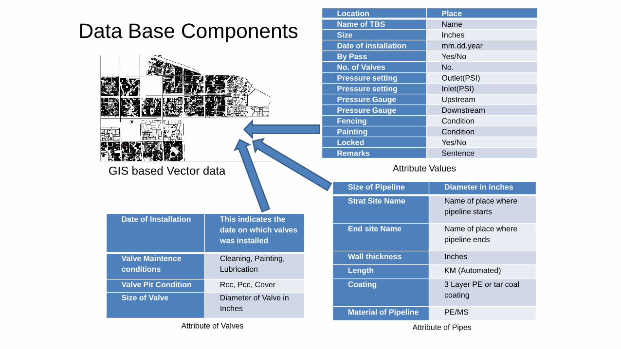
Data Base Components
Size of Pipeline Diameter in inches
Strat Site Name Name of place where
pipeline starts
End site Name Name of place where
pipeline ends
Wall thickness Inches
Length KM (Automated)
Coating 3 Layer PE or tar coal
coating
Material of Pipeline PE/MS
Date of Installation This indicates the
date on which valves
was installed
Valve Maintence
conditions
Cleaning, Painting,
Lubrication
Valve Pit Condition Rcc, Pcc, Cover
Size of Valve Diameter of Valve in
Inches
Attribute of Valves
Location Place
Name of TBS Name
Size Inches
Date of installation mm.dd.year
By Pass Yes/No
No. of Valves No.
Pressure setting Outlet(PSI)
Pressure setting Inlet(PSI)
Pressure Gauge Upstream
Pressure Gauge Downstream
Fencing Condition
Painting Condition
Locked Yes/No
Remarks Sentence
Attribute Values GIS based Vector data
Attribute of Pipes

GIS based Analysis required everyday
Query Percentage of queries How many Pipelines in KMs of Specific
Diameter in an area?
40%
Measuring the length of Pipeline on
screen?
20%
Editing and drawing new features? 1%
How to Search a Place by its name? 1%
Coordinate of Specific Point in the map
with its name or coordinates?
1%
Map creation on specific scale? 30%
How to Share data with others in .JPG
format?
5%
How to Draw coordinate of specific
place on the map?
4%

Conclusions
•Proposal Preparation
•Help in Centralized Management •Mitigation of Manual Drawings •Mitigation of Staff •Compliance of Regulations
Institute of Geology
University of the Punjab, Pakistan
www.pu.edu.pk

References •Goodchild, M. .. (1992). Geographical Information Science. Santa Barbarar, CA 93106, U.S.A: National Center for Geographical Information and Analysis, Univeristy of California. •Haining, R. (2008). Entrprise GIS Powring the utility of the future. Sydney, Australia: GITA. •Iqbal, F. a. (2010). Energy for Pakistan: A sustainable strategic contingency perspective. . 1st international conference on Sustainable urbanization (pp. 15-20). Hong Kong: Uni of Hong Kong. •Iqbal, F. a. (2011). Geoinformatics based agro ecological modeling for Sustainable agriculture. First international Symposium (pp. 70-75). Jedha, Saudi Arabia: King AbdullAziz University. •Iqbal, F., & Mehdi, M. (2008). Detection of suitable soils for Zero-Till Wheat Cultivation in Pakistan using GITs. . Earth Observation and Remote Sensing Applications (pp. 1-6). Beijing- China : IEEE. •Pakistan, G. o. (2009). Oil and Gad Regulatory Authority. Islamabad: Govt. of Pakistan. •Pickering, D. (1994). Utility mapping and record keeping for infrastructure (Vol. 4). (4, Ed.) Washington D.C., U.S.A: World Bank and Urban Management Program. •Salo, J. E. (2002). How a utiliity using asset management to become more compitative. Procedding ot water envirnment federation (pp. 788-800). WEFTEC. •Weibin, Y. Z. (2006). Study and progress of integrity management system for oil and gas pipline. Oil and Gas Storage and transportation, 50-60.
Institute of Geology
University of the Punjab, Pakistan
www.pu.edu.pk
Thanks
Institute of Geology
University of the Punjab, Pakistan
www.pu.edu.pk
Furqan Iqbal
Officer Sui Northern Gas Pipelines Limited
Phone: 0470432323, +923344055563
Email: [email protected]
www.sngpl.com.pk