GIS INTERFACE FOR ANNAGNPS - University of...
31
GIS INTERFACE FOR ANNAGNPS DEM, LAND USE/LAND COVER, AND SOIL DATA PREPARATION VOLUME 2: PROCEDURES OF DATA PREPARATION
Transcript of GIS INTERFACE FOR ANNAGNPS - University of...

GIS INTERFACE FOR ANNAGNPS
DEM, LAND USE/LAND COVER, AND SOIL DATA PREPARATION
VOLUME 2: PROCEDURES OF DATA PREPARATION
GIS INTERFACE FOR ANNAGNPS
DEM, LAND USE/LAND COVER, AND SOIL DATA PREPARATION
VOLUME 2: PROCEDURES OF DATA PREPARATION
SEPTEMBER 2003
CENTRAL PLAINS CENTER FOR BIOASSESSMENT KANSAS BIOLOGICAL SURVEY
AND KANSAS GEOLOGICAL SURVEY
UNIVERSITY OF KANSAS AND
NATURAL RESOURCES CONSERVATION SERVICE U.S. DEPARTMENT OF AGRICULTURE
AND U.S. ENVIRONMENTAL PROTECTION AGENCY
REGION VII

ACKNOWLEDGMENT
This report of AnnAGNPS-GIS data preparation was organized with assistance primarily from Jeff Anderson of the Kansas Biological Survey. Technical information from Dr. Xiaoyoung Zhan of the Kansas Geological Survey and Kevin Dobbs and Jerry Whistle of the Kansas Biological Survey are gratefully acknowledged
Special thanks are given to Lyle Frees of the Natural Resource Conservation Service, U.S. Department of Agriculture; Dr. Sean Kruger of the Department of Environment and Natural Resources, South Dakota for their help in assisting the data preparation and/or reviewing the report.
The assistance, advice, and comments of the Center Plains Center for BioAssessment director, Dr. Donald G. Huggins, have been of great value in preparing this report. Editorial comments from associate director of Center Plains Center for BioAssessment, Ms. Debbie Baker, greatly enhance the quality of this report. This project is funded from the U.S. Environmental Protection Agency through award number X-99797001-0 to the Kansas Biological Survey.

TABLE OF CONTENTS
1. PREPARATION OF DEM DATA................................................................................. 1 1.1. Locate DEM Data .................................................................................................... 1 1.2. Identify DEMs for a Study Area.............................................................................. 2 1.3. Download DEMs ..................................................................................................... 3 1.4. View DEMs ............................................................................................................. 3 1.5. Merge DEMs converted Grids ................................................................................. 5
1.5.1. Copy the Avenue merging script ....................................................................... 5 1.5.2. Load the script .................................................................................................. 6 1.5.3. Running the script ............................................................................................. 6
2. PREPARATION OF LAND USE/LAND COVER DATA ........................................... 9 2.1. Locate Land Use/Land Cover Data ......................................................................... 9 2.2. Identify Land Use/Land Cover Data for a Study Area ............................................ 9 2.3. Download Land Use/Land Cover Data.................................................................. 10 2.4. View Land Use/Land Cover .................................................................................. 11 2.5. Merge Land Use/Land Cover ................................................................................ 12 2.6. Dissolve Land Use/Land Cover ............................................................................. 15
3. PREPARATION OF SOIL DATA............................................................................... 23 3.1. Locate and Download Soil Data ........................................................................... 23 3.2. Add MUID Codes and Calculate Area and Perimeter .......................................... 24 3.3. Merge Soil Data ..................................................................................................... 26
REFERENCES ................................................................................................................. 27

DATA PREPARATION____________________________________________________
This report provides a general guidance for users to gather DEMs, land use/land cover, and soil data of interest prior to the use of AnnAGNPS watershed model and its interface. This guidance outlines steps using ArcView� (v3.3) primarily for Kansas, these steps may be applied to other states. The Spatial Analyst� extension is required for merging DEMs grid data while the Geoprocessing� and Projection Utility Wizard� extensions are needed for merging, dissolving, and projecting both land use/land cover and/or soil data.
The merging steps may be used to join DEMs and land use and soil coverages
together from different counties for a large watershed. However, extensive efforts and time may be required using these steps if elevation or other factors (e.g., datum and projection) considerably vary between counties. For example, the Clinton Lake watershed encompasses nearly 95,320 ha and is comprised of four counties (Douglas, Shawnee, Osage, and Wabaunsee), which includes at least 10 DEMs that need to be merged in order to produce a complete watershed coverage. Though seamless DEMs were created in the same county, marked difference was noted along some of the county boundaries. Thus, the national seamless DEM database (http://seamless.usgs.gov) from the U.S. Geological Survey is used because it provides fairly high resolution 30-m DEMS for watershed modeling. The downloaded seamless data needs to be reprojected with the aid of Arc/Info, however. Users should use whichever is appropriate for their study. 1. PREPARATION OF DEM DATA
1.1. Locate DEM Data Kansas – Data Access and Support Center (DASC) of the Kansas Geological
Survey (KGS) (http://gisdasc.kgs.ukans.edu/) Missouri – Missouri Spatial Data Information Service of the University of
Missouri-Columbia (http://msdis.missouri.edu/) Iowa – Iowa Geographic Image Map Server of the Iowa State University
(http://ortho.gis.iastate.edu/) Nebraska – Institute of Agriculture and Natural Resources of the University of
Nebraska-Lincoln (http://csd.unl.edu/csd/genlinfo/datasets.html) United States – National Elevation Dataset (NED) of the U.S. Geological Survey
(http://seamless.usgs.gov)
1
DATA PREPARATION____________________________________________________
1.2. Identify DEMs for a Study Area
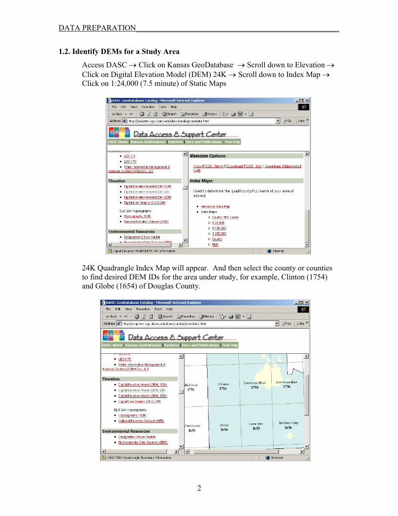
Access DASC � Click on Kansas GeoDatabase � Scroll down to Elevation � Click on Digital Elevation Model (DEM) 24K � Scroll down to Index Map � Click on 1:24,000 (7.5 minute) of Static Maps
24K Quadrangle Index Map will appear. And then select the county or counties to find desired DEM IDs for the area under study, for example, Clinton (1754) and Globe (1654) of Douglas County.
2

DATA PREPARATION____________________________________________________
1.3. Download DEMs
Access DASC � Click on Kansas GeoDatabase � Scroll down to Elevation � Click on Digital Elevation Model (DEM) 24K � Click on Download Data (or ftp://gisdasc.kgs.ukans.edu/gisdata/dem/dem_24k or using WS FTP to connect to gisdasc.kgs.ku.edu with username:anonymous and password:your@emailaddress)
Click on row 16 to find 1654 for Globe and download it. Likewise, click on row 17 to locate 1754 for Clinton and then download it. Then, unzip the downloaded DEM files.
1.4. View DEMs
Open ArcView (v3.3) � Load Spatial Analyst extension � Click on Import Data Source � Select USGS DEM (import file type) � Click on OK (the USGS DEMs will be converted to grid files)
3

DATA PREPARATION____________________________________________________
Select the downloaded DEMs
Name Output Grid Files (Clinton/1754 and Globe/1654).
4
DATA PREPARATION____________________________________________________
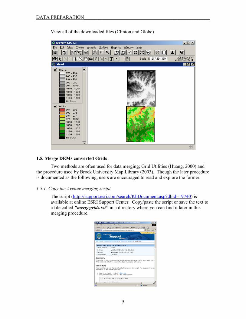
View all of the downloaded files (Clinton and Globe).
1.5. Merge DEMs converted Grids Two methods are often used for data merging; Grid Utilities (Huang, 2000) and
the procedure used by Brock University Map Library (2003). Though the later procedure is documented as the following, users are encouraged to read and explore the former. 1.5.1. Copy the Avenue merging script
The script (http://support.esri.com/search/KbDocument.asp?dbid=19740) is available at online ESRI Support Center. Copy/paste the script or save the text to a file called "mergegrids.txt" in a directory where you can find it later in this merging procedure.
5

DATA PREPARATION____________________________________________________
1.5.2. Load the script Click on the Scripts option, and then click New. A blank script window appears. Option 1: Copy and Paste the script.
Option 2: From the Script dropdown menu, choose Load Text File. In the Load Script dialogue box, browse to the directory where you saved the script earlier, select the file and click OK.
Click the compile button to compile the script file.
1.5.3. Running the script Complete the following steps in precise order. Prior to that, ensure the Script window active (i.e., title bar in dark blue color).
1. Click the View window showing the DEMs to be merged. 2. Click the first DEM in the legend to make it active. 3. Click the script window title bar to activate it. 4. Click the run button . You will be prompted with the Create Grid
Mosaic dialogue box. Select one or more (hold shift key) DEMs to merge with the first DEM and click OK.
6

DATA PREPARATION____________________________________________________
The merged grid is added to your View. Turn the new layer on to see the merged file.
7
DATA PREPARATION____________________________________________________
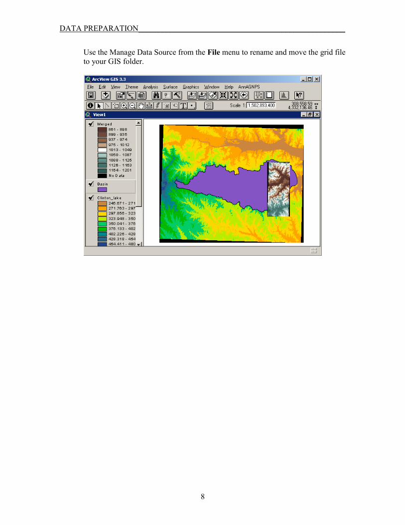
Use the Manage Data Source from the File menu to rename and move the grid file to your GIS folder.
8
DATA PREPARATION____________________________________________________
2. PREPARATION OF LAND USE/LAND COVER DATA
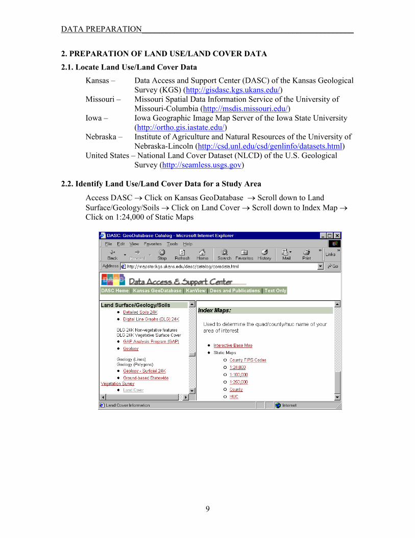
2.1. Locate Land Use/Land Cover Data Kansas – Data Access and Support Center (DASC) of the Kansas Geological
Survey (KGS) (http://gisdasc.kgs.ukans.edu/) Missouri – Missouri Spatial Data Information Service of the University of
Missouri-Columbia (http://msdis.missouri.edu/) Iowa – Iowa Geographic Image Map Server of the Iowa State University
(http://ortho.gis.iastate.edu/) Nebraska – Institute of Agriculture and Natural Resources of the University of
Nebraska-Lincoln (http://csd.unl.edu/csd/genlinfo/datasets.html) United States – National Land Cover Dataset (NLCD) of the U.S. Geological
Survey (http://seamless.usgs.gov) 2.2. Identify Land Use/Land Cover Data for a Study Area
Access DASC � Click on Kansas GeoDatabase � Scroll down to Land Surface/Geology/Soils � Click on Land Cover � Scroll down to Index Map � Click on 1:24,000 of Static Maps
9

DATA PREPARATION____________________________________________________
24K Quadrangle Index Map will appear.
2.3. Download Land Use/Land Cover Data
Access DASC � Click on Kansas GeoDatabase � Scroll down to Land Surface/Geology/Soils � Click on Land Cover � Scroll down to click on Download Data (or ftp://gisdasc.kgs.ukans.edu/gisdata/landcove or using WS FTP to connect to gisdasc.kgs.ku.edu with username:anonymous and password:your@emailaddress)
10
DATA PREPARATION____________________________________________________
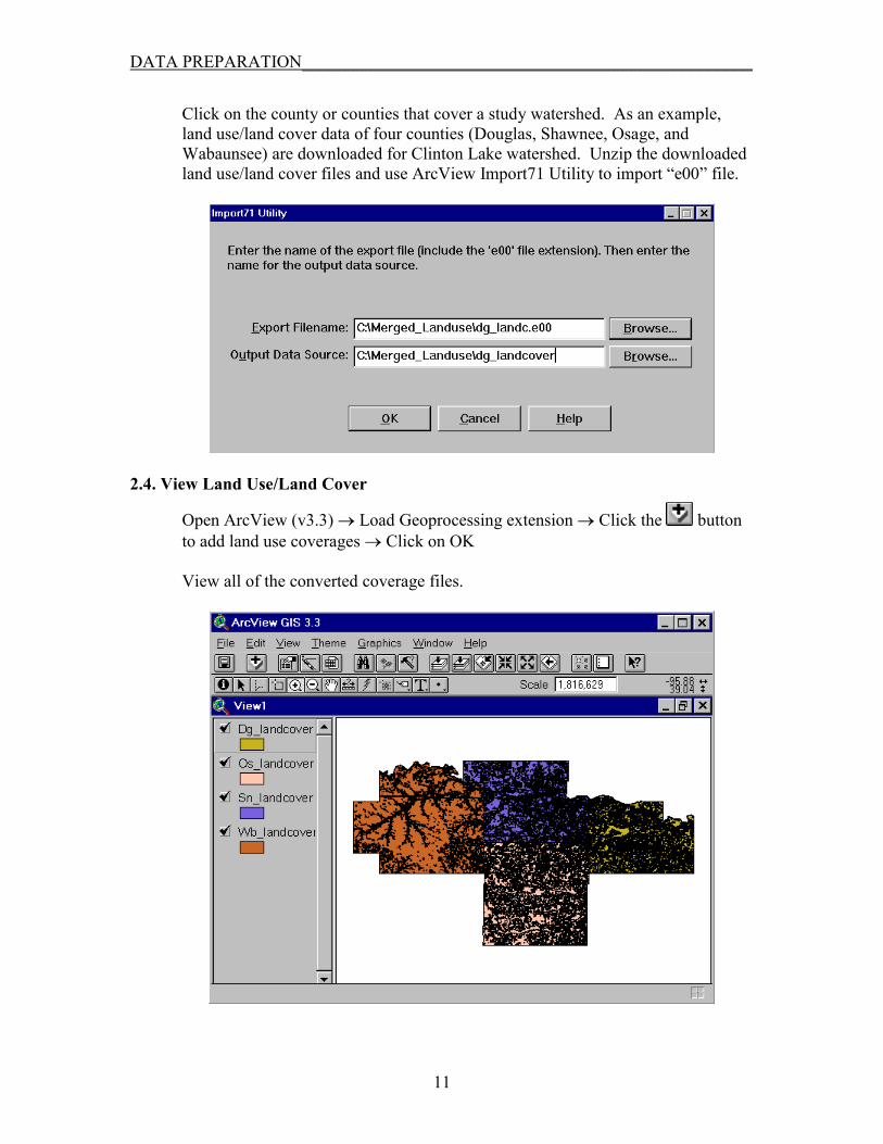
Click on the county or counties that cover a study watershed. As an example, land use/land cover data of four counties (Douglas, Shawnee, Osage, and Wabaunsee) are downloaded for Clinton Lake watershed. Unzip the downloaded land use/land cover files and use ArcView Import71 Utility to import “e00” file.
2.4. View Land Use/Land Cover
Open ArcView (v3.3) � Load Geoprocessing extension � Click the button to add land use coverages � Click on OK
View all of the converted coverage files.
11
DATA PREPARATION____________________________________________________
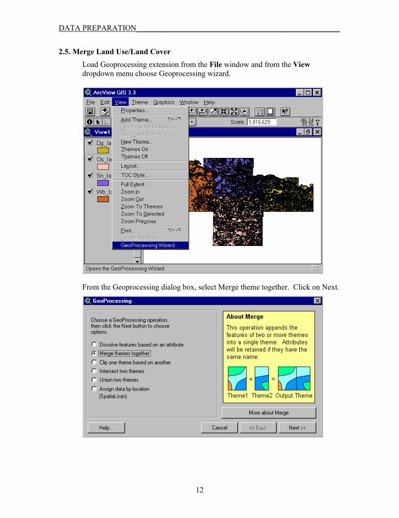
2.5. Merge Land Use/Land Cover Load Geoprocessing extension from the File window and from the View dropdown menu choose Geoprocessing wizard.
From the Geoprocessing dialog box, select Merge theme together. Click on Next.
12
DATA PREPARATION____________________________________________________
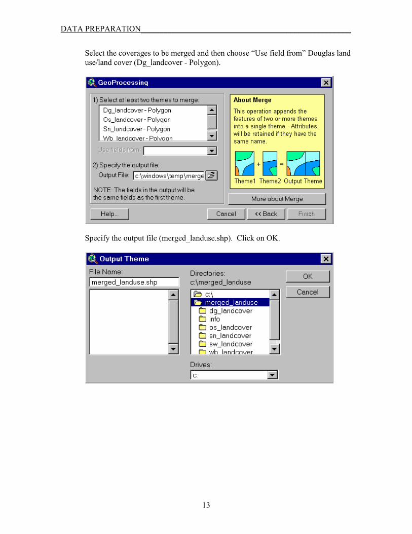
Select the coverages to be merged and then choose “Use field from” Douglas land use/land cover (Dg_landcover - Polygon).
Specify the output file (merged_landuse.shp). Click on OK.
13
DATA PREPARATION____________________________________________________
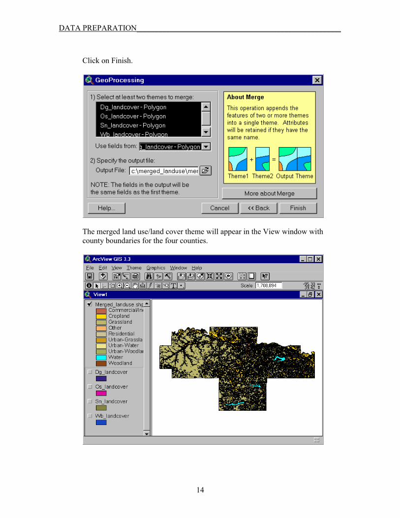
Click on Finish.
The merged land use/land cover theme will appear in the View window with county boundaries for the four counties.
14
DATA PREPARATION____________________________________________________
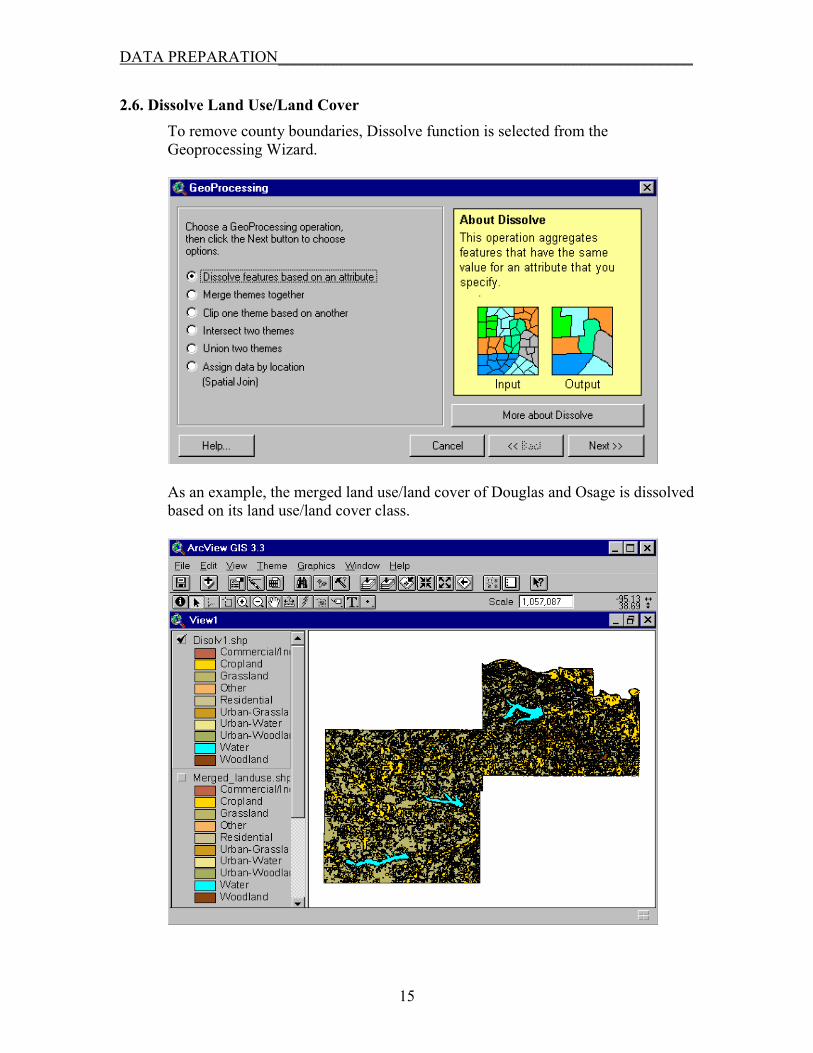
2.6. Dissolve Land Use/Land Cover To remove county boundaries, Dissolve function is selected from the Geoprocessing Wizard.
As an example, the merged land use/land cover of Douglas and Osage is dissolved based on its land use/land cover class.
15

DATA PREPARATION____________________________________________________
Users have another approach to prepare land use/land cover data by accessing online National Land Cover Dataset (NLCD) at http://seamless.usgs.gov as the following. Selected NLCD from the online USGS website (http://seamless.usgs.gov) and click on View and Order Data Sets.
You will be prompted to Seamless Data Distribution System Viewer to select your study area.
16

DATA PREPARATION____________________________________________________
Use Zoom In function to a desired size of this study site and then click on the
button to download the selected area.
Import the downloaded land use/land cover as grid through Spatial Analyst extension. (A land use/land cover class field can be added into its associated table.)
17
DATA PREPARATION____________________________________________________
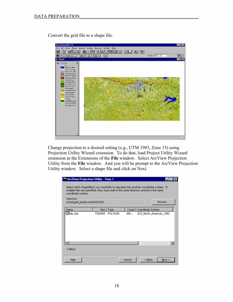
Convert the grid file to a shape file.
Change projection to a desired setting (e.g., UTM 1983, Zone 15) using Projection Utility Wizard extension. To do that, load Project Utility Wizard extension in the Extensions of the File window. Select ArcView Projection Utility from the File window. And you will be prompt to the ArcView Projection Utility window. Select a shape file and click on Next.
18
DATA PREPARATION____________________________________________________
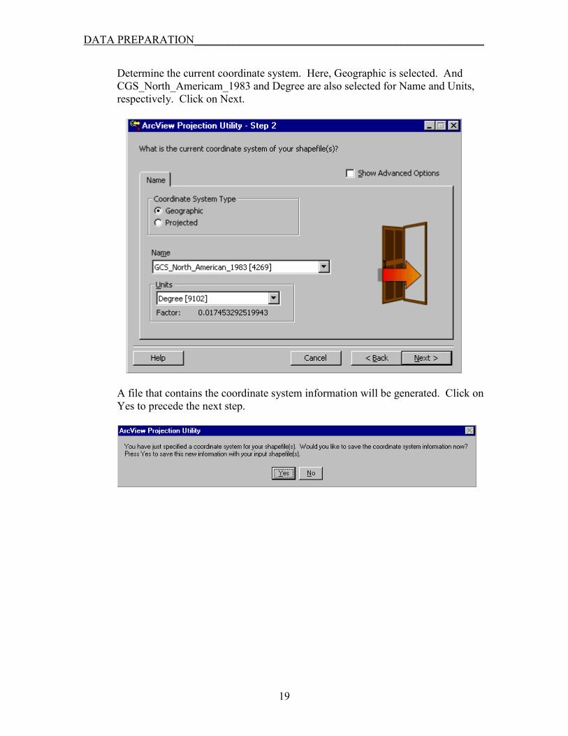
Determine the current coordinate system. Here, Geographic is selected. And CGS_North_Americam_1983 and Degree are also selected for Name and Units, respectively. Click on Next.
A file that contains the coordinate system information will be generated. Click on Yes to precede the next step.
19

DATA PREPARATION____________________________________________________
Select a proper setting for a new coordinate system and Click on Next.
You will be prompt to a new window and asked where to save to the projected file (e.g., newshape_utm15.shp) from Browse. Click on the button Save and then the Next button to finish the projection process.
20

DATA PREPARATION____________________________________________________
Preferably, this projected file is organized in a new View with the same projection for a better data manipulation.
Use the Dissolve function of Geoprocessing extension to aggregate land use/land cover polygons and specify the output file.
21
DATA PREPARATION____________________________________________________
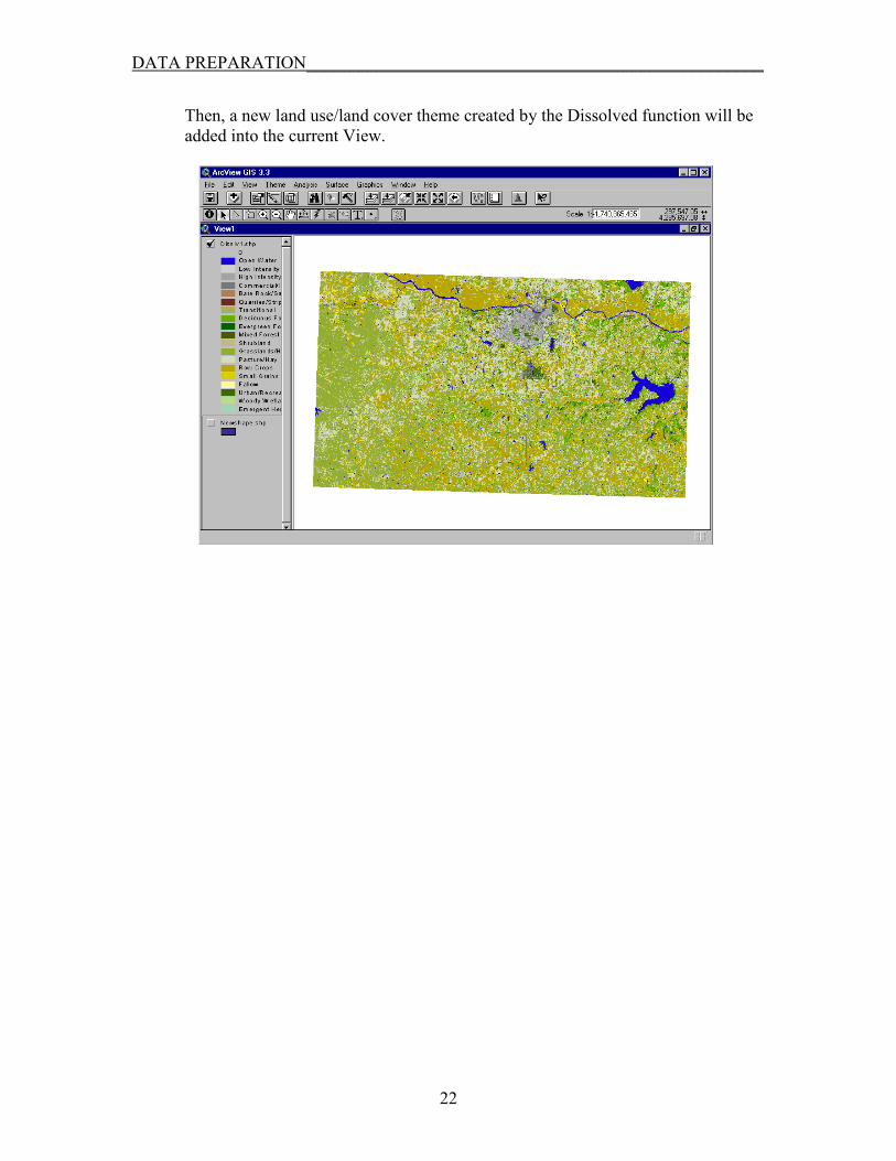
Then, a new land use/land cover theme created by the Dissolved function will be added into the current View.
22

DATA PREPARATION____________________________________________________
3. PREPARATION OF SOIL DATA 3.1. Locate and Download Soil Data
The Soil Survey Geographic (SSURGO v2) soil information is primarily used for this watershed and lake modeling project. Soil coverage data can be downloaded from the Natural Resources Conservation Service website at http://www.ftw.nrcs.usda.gov/ssurgo_ftp3.html for the county or counties that covers the study watershed. State soil data of Kansas (STATSGO or SSURGO v1) can be also accessed at the DASC website (http://gisdasc.kgs.ukans.edu/).
As an example, four county soil data (KS-197, KS-177, KS-139 and KS-045) are downloaded from NRCS website and converted to shape files for Clinton Lake watershed.
Then these data are projected to match the DEM projection (e.g., UTM-1983, Zoom 15). To do that, load Project Utility Wizard extension in the Extensions of the File window. Select ArcView Projection Utility from the File window. And use the same steps documented in the land use/land cover section.
23

DATA PREPARATION____________________________________________________
3.2. Add MUID Codes and Calculate Area and Perimeter To properly identify soil data, MUID needs to be created to the projected data by adding county codes. Click the table button for a selected data. From the Table window, select Start Editing.
Then, select Add Field from the Edit dropdown menu
24

DATA PREPARATION____________________________________________________
Assign the field properties from the Field Definition window.
Make Calculator active and add the Muid codes (“045”+[Musym]). The unique code for Douglas county is 045. Click on OK.
To change area and perimeter values, highlight the Area (and then perimeter) field and select Calculator. Type [shape].returnarea code to change area value and [shape].returnlength for perimeter value. Save the changes by selecting Stop Editing from the Edit window. These steps need to be used for each soil theme.
25

DATA PREPARATION____________________________________________________
3.3. Merge Soil Data Load Geoprocessing extension from the Extensions of the File window. And follow the merging steps described in the land use/land cover section. Select the desired counties and set an appropriate output file name. Click on OK to finish the process.
26
DATA PREPARATION____________________________________________________
REFERENCES Brock University Map Library, 2003. Internet accessed – April 2, 2003 at URL http://www.brocku.ca/maplibrary/procedures/DEMmerge.htm. Huang, M.L. 2000. Grid Utilities (v1.1). Internet accessed – April 8, 2003 at URL http://arcscripts.esri.com/details.asp?dbid=10199
27