
GIS-based Decision Support System (DSS) for Recommending Retail Outlet Locations
11
Information and Knowledge Management www.iiste.org ISSN 2224-5758 (Paper) ISSN 2224-896X (Online) Vol.3, No.4, 2013 57 GIS-based Decision Support System (DSS) for Recommending Retail Outlet Locations Sreekanth PD 1* , Kumar KV 1 , Soam SK 1 , Rao NH 1 and Bhaskar Kannoju 2 1. Department of ICM, National Academy of Agricultural Research Management, Hyderabad, Andhra Pradesh, India 2. Adepto Geo Informatics, Hyderabad, Andhra Pradesh, India * E-mail of the corresponding author: [email protected] Abstract Many Information Technology (IT) tools play a vital role in the business world due to their wider applicability. Extremely competitive retail environment necessitates retailers to choose new store locations strategically. GIS with its capability to manage, display and analyze business information spatially, is emerging as one of the powerful location intelligence IT tool. The purpose of this paper is to explore the possibility of strategic retail outlet location through online Decision Support System (DSS) in Hyderabad Metropolitan city, India. The procedure makes use of data, information and software from Web-based Geographical Information Systems (GIS) to generate online analysis, mapping and visualization systems. These procedures are integrated and synchronized with appropriate data layers (multi data layer system) to arrive at better decisions. This DSS combines different data layers through spatial methodological analysis to arrive at possible solution for ideal retail store location. Keywords: Retail store site selection; spatial data layers; open source web GIS; DSS. 1. Introduction The retail industry is focused on the sale of goods or merchandise from a specific location for direct consumption by the purchaser. The Indian retail industry is the fifth largest in the world comprising of both organized and unorganized sectors. The Indian retail industry is the fastest growing industries of India, especially over the last few years accounting for over 10 per cent of the country’s GDP and around 8 per cent of the employment (Indian Retail Industry, 2012), (Dhanabhakyam, 2012). The Indian retail market is expected to grow to US $833 billion by 2013 and to $1.3 trillion by 2018, at a CAGR of 10 per cent (A. T. Kearney, Report, 2008). Retail site selection is a very important decision and has to be done carefully because the success or failure of a business depends to a great extent on its location (Khan, 1992; Khan, 1999). An ideal location is one of the most important elements that customers consider while choosing a store. When chosen, a retailer must live with the site for many years because of the financial intricacies involved. Due to dearth of land in cities it is mostly hard to find ideal retail shop location (Levy 2001). The specific site selection involves several criterion viz., size/characteristics of population, income potential, level of competition, existing retail locations, access to transportation, availability of parking, attributes of nearby stores, accessibility of major highway/other road networks, number and types of stores in area etc., (Barry Berman and Evans, 2010). Analyzing the above parameters for retail site selection manually is a cumbersome and time consuming process. In recent past, DSS are being employed by retailers as vital support for making crucial decisions for both day-to-day activities to long term strategic decision making like location of new stores. A DSS is an integrated set of computer tool that allows decision makers to interact directly with computers to create information useful in making semi-structured and unstructured decisions. The software components for DSS is a problem processing system which is made up of several components that perform various processing tasks supported by a knowledge system that provides data and artificial intelligence capabilities to the DSS (Sanjay Kumar 2011). Further, the web Geographic Information System (GIS) has been in use as input to DSS by retailers (Syed Nasirin, 2003). The research in this context during the last decade focused on utilizing GIS as one of the crucial Information Technology (IT) application for spatial analysis/site decision (M.F. Goodchild, 1991, M.W. Michelsen 1994, I. Clarke, 1995, J.F. Tayman 1995) and determining the appropriate promotional media mainly through GIS clustering feature.
-
Upload
alexander-decker -
Category
Documents
-
view
213 -
download
0
description
Â
Transcript of GIS-based Decision Support System (DSS) for Recommending Retail Outlet Locations

Information and Knowledge Management www.iiste.org ISSN 2224-5758 (Paper) ISSN 2224-896X (Online) Vol.3, No.4, 2013
57
GIS-based Decision Support System (DSS) for Recommending
Retail Outlet Locations
Sreekanth PD1*
, Kumar KV1, Soam SK
1, Rao NH
1 and Bhaskar Kannoju
2
1. Department of ICM, National Academy of Agricultural Research Management, Hyderabad, Andhra Pradesh,
India
2. Adepto Geo Informatics, Hyderabad, Andhra Pradesh, India
* E-mail of the corresponding author: [email protected]
Abstract
Many Information Technology (IT) tools play a vital role in the business world due to their wider
applicability. Extremely competitive retail environment necessitates retailers to choose new store locations
strategically. GIS with its capability to manage, display and analyze business information spatially, is emerging as
one of the powerful location intelligence IT tool. The purpose of this paper is to explore the possibility of strategic
retail outlet location through online Decision Support System (DSS) in Hyderabad Metropolitan city, India. The
procedure makes use of data, information and software from Web-based Geographical Information Systems (GIS) to
generate online analysis, mapping and visualization systems. These procedures are integrated and synchronized with
appropriate data layers (multi data layer system) to arrive at better decisions. This DSS combines different data
layers through spatial methodological analysis to arrive at possible solution for ideal retail store location.
Keywords: Retail store site selection; spatial data layers; open source web GIS; DSS.
1. Introduction
The retail industry is focused on the sale of goods or merchandise from a specific location for direct
consumption by the purchaser. The Indian retail industry is the fifth largest in the world comprising of both
organized and unorganized sectors. The Indian retail industry is the fastest growing industries of India, especially
over the last few years accounting for over 10 per cent of the country’s GDP and around 8 per cent of the
employment (Indian Retail Industry, 2012), (Dhanabhakyam, 2012). The Indian retail market is expected to grow to
US $833 billion by 2013 and to $1.3 trillion by 2018, at a CAGR of 10 per cent (A. T. Kearney, Report, 2008).
Retail site selection is a very important decision and has to be done carefully because the success or failure of a
business depends to a great extent on its location (Khan, 1992; Khan, 1999). An ideal location is one of the most
important elements that customers consider while choosing a store. When chosen, a retailer must live with the site for
many years because of the financial intricacies involved. Due to dearth of land in cities it is mostly hard to find
ideal retail shop location (Levy 2001). The specific site selection involves several criterion viz., size/characteristics
of population, income potential, level of competition, existing retail locations, access to transportation, availability of
parking, attributes of nearby stores, accessibility of major highway/other road networks, number and types of stores
in area etc., (Barry Berman and Evans, 2010).
Analyzing the above parameters for retail site selection manually is a cumbersome and time consuming process.
In recent past, DSS are being employed by retailers as vital support for making crucial decisions for both day-to-day
activities to long term strategic decision making like location of new stores. A DSS is an integrated set of computer
tool that allows decision makers to interact directly with computers to create information useful in making
semi-structured and unstructured decisions. The software components for DSS is a problem processing system which
is made up of several components that perform various processing tasks supported by a knowledge system that
provides data and artificial intelligence capabilities to the DSS (Sanjay Kumar 2011). Further, the web Geographic
Information System (GIS) has been in use as input to DSS by retailers (Syed Nasirin, 2003). The research in this
context during the last decade focused on utilizing GIS as one of the crucial Information Technology (IT) application
for spatial analysis/site decision (M.F. Goodchild, 1991, M.W. Michelsen 1994, I. Clarke, 1995, J.F. Tayman 1995)
and determining the appropriate promotional media mainly through GIS clustering feature.

Information and Knowledge Management www.iiste.org ISSN 2224-5758 (Paper) ISSN 2224-896X (Online) Vol.3, No.4, 2013
58
A GIS is an organized collection of computer hardware, software, geographic and personnel data designed to
efficiently capture, store, update, manipulate, analyze and display many forms of geographically referenced
information (ESRI, 1995). Presently, internet is becoming a popular global common platform where organizations
and business people communicate with each other to carry out various commercial activities to provide value-added
services to their clientele (Fensel, D 2002). Thus, Web GIS holds the potential to make distributed geographic
information (DGI) available to a very large worldwide audience. In principle, the Web GIS is available for the public
to participate in finding the solutions to a wide variety of real-world spatial problems and allows the users to examine
the spatial information and meta-data (ISPRS, 2006). Thereby, the user has choice to add own information in
multimedia formats, and discuss as well as share the datasets forming interested own communities. Further, the
spatial datasets can be examined and manipulated in person to run “what if” scenario models to reach an informed
decision. Thus, web services allow implementation of a decentralized paradigm for creation of a complex distributed
applications from multiple GIS services which provide limited functions to the local data (Lazarova and Angelova,
2008). In the present study, the main focus was to assess the characteristics of markets, existing competition and
population demographics to create proximity analysis for understanding the market areas to provide spatial DSS for
identifying potential market areas for establishing the future retail stores in Hyderabad (17.3667° N, 78.4667° E),
India.
2. Methodology
The input data for all layers in the present study were purchased from MapmyIndia.com and the information
regarding the existing major retail stores was collected from search engines (Figure 1).
During development of web-based DSS, the main emphasis was given for the ease of use and support for open
standards in order to enable the user to quickly share their geospatial information in an interoperable way. With the
recent research on adopting web services for various GIS applications, the issue of sharing spatial data has taken a
new dimension. With web services, it becomes possible for applications to acquire and integrate spatial data from
heterogeneous sources in real time over the web. The Open Geospatial Consortium (OGC) web services provide a
vendor-neutral interoperable framework for web-based discovery, access, integration, analysis and visualization of
multiple online geospatial data sources (Sanjay Kumar 2011). The details of components used for establishing the
DSS in the present study are given herewith.
a. Server
i. GeoServer
GeoServer - an open-source server written in Java was used that allows users to share and edit geospatial data.
Designed for interoperability, it publishes data from any major spatial data source using open standards. Being a
community-driven project, GeoServer is developed, tested, and supported by a diverse group of individuals and
organizations from around the world. GeoServer is the reference implementation of the OGC Web Feature Service
(WFS) and Web Coverage Service (WCS) standards, as well as a high performance certified compliant Web Map
Service (WMS). GeoServer forms a core component of the Geospatial Web
(http://geoserver.org/display/GEOS/Welcome).
ii. Apache
The Apache HTTP Server commonly referred as Apache, notable for playing a key role in the initial growth of
the World Wide Web is used as web server software. Apache is developed and maintained by an open community of
developers under the auspices of the Apache Software Foundation. The application is available for a wide variety of
operating systems, including Unix, FreeBSD, Linux, Solaris, Novell NetWare, Mac OS X, Microsoft Windows, OS/2,
TPF, and eComStation. Released under the Apache License, Apache is open-source software
(http://en.wikipedia.org/wiki/Apache_HTTP_Server).
b. Coding/ Scripting
i. HTML
Hyper Text Markup Language (HTML), the main markup language for web pages was used for scripting.
Usually HTML elements are the basic building-blocks of web pages and allow images/objects embedding to create

Information and Knowledge Management www.iiste.org ISSN 2224-5758 (Paper) ISSN 2224-896X (Online) Vol.3, No.4, 2013
59
interactive forms. It provides a means to create structured documents by denoting structural semantics for text such
as headings, paragraphs, lists, links, quotes and other items. It can embedded scripts in languages such as JavaScript
which affect the behaviour of HTML web pages (http://en.wikipedia.org/wiki/HTML).
ii. PHP
PHP is a general-purpose server-side scripting language originally designed for web development to produce
dynamic web pages. It is one of the first developed server-side scripting languages to be embedded into an HTML
source document, rather than calling an external file to process data. Ultimately, the code is interpreted by a web
server with a PHP processor module which generates the resulting web page. It also has evolved to include a
command-line interface capability and can be used in standalone graphical applications
(http://en.wikipedia.org/wiki/PHP#cite_note-1).
iii. JavaScript
JavaScript is a prototype-based scripting language that is dynamic, weakly typed and has first-class functions. It
is a multi-paradigm language, supporting object-oriented, imperative, and functional programming styles. JavaScript
was formalized in the ECMA Script language standard and is primarily used in the form of client-side JavaScript,
implemented as part of a web browser in order to provide enhanced user interfaces and dynamic websites. This
enables programmatic access to computational objects within a host environment
(http://en.wikipedia.org/wiki/JavaScript#cite_note-ECMA-262-4).
c. Libraries
i. jQuery
jQuery is a cross-browser JavaScript library designed to simplify the client-side scripting of HTML. jQuery is
free, open source software, dual-licensed under the MIT License or GNU General Public License, Version 2. jQuery's
syntax is designed to make it easier to navigate a document, select DOM elements, create animations, handle events,
and develop Ajax applications. jQuery also provides capabilities for developers to create plug-ins on top of the
JavaScript library. This enables developers to create abstractions for low-level interaction and animation, advanced
effects and high-level, theme-able widgets. The modular approach to the jQuery library allows the creation of
powerful dynamic web pages and web applications (http://en.wikipedia.org/wiki/JQuery).
ii. jQuery UI
jQuery UI is a JavaScript library that provides abstractions for low-level interaction and animation, advanced
effects and high-level, themeable widgets, built on top of the jQuery JavaScript library, that can be used to build
interactive web applications. jQuery UI is free, open source software, dual-licensed under the MIT License and the
GNU General Public License, Version 2 (http://en.wikipedia.org/wiki/JQuery_UI).
d. Technology
i. AJAX
AJAX, an acronym for Asynchronous JavaScript and XML, is a group of interrelated web development
techniques used on the client-side to create asynchronous web applications. With Ajax, web applications can send
data to, and retrieve data from, a server asynchronously (in the background) without interfering with the display and
behavior of the existing page. JavaScript and the XMLHttpRequest object provide a method for exchanging data
asynchronously between browser and server to avoid full page reloads (http://en.wikipedia. org/ wiki/ Ajax_%28
programming%29).
ii. GeoWebCache
GeoWebCache is a Java web application used to cache map tiles coming from a variety of sources such as OGC
Web Map Service (WMS). It implements various service interfaces (such as WMS-C, WMTS, TMS, Google Maps
KML, Virtual Earth) in order to accelerate and optimize map image delivery. It can also recombine tiles to work with
regular WMS clients. GeoWebCache is licensed under the GNU Lesser General Public License (LGPL)
(http://geowebcache.org/).

Information and Knowledge Management www.iiste.org ISSN 2224-5758 (Paper) ISSN 2224-896X (Online) Vol.3, No.4, 2013
60
e. Style
i. Cascading Style Sheets (CSS)
CSS is a style sheet language used for describing the presentation semantics (the look and formatting) of a
document written in a markup language. It’s most common application is to style web pages written in HTML and
XHTML, but can also be applied to any kind of XML document, including plain XML, SVG and XUL. CSS is
designed primarily to enable the separation of document content (written in HTML or a similar markup language)
from document presentation, including elements such as the layout, colors, and fonts. This separation can improve
content accessibility, provide more flexibility and control in the specification of presentation characteristics, enable
multiple pages to share formatting, and reduce complexity and repetition in the structural content
(http://en.wikipedia.org/wiki/ Cascading _Style_Sheets).
ii. Styler
Styler is built on open standards, using the Styled Layer Descriptor (SLD) XML language at the center. It is
rendered with the Web Map Service (WMS) standard, which has extensions to render remote SLDs, and uses REST
calls to persist styles to servers. It is built with GeoServer as an initial target, but the emphasis on open standards and
flexible design should make it adaptable to any WMS server
(http://gis.stackexchange.com/questions/25070/text-layer-styling-in-geoserver).
f. Databases
i. PostgreSQL
PostgreSQL, often simply Postgres, is an object-relational database management system (ORDBMS) available for
many platforms including Linux, FreeBSD, Solaris, Microsoft Windows and Mac OS X. It is released under the
PostgreSQL License, which is an MIT-style License, and is thus free and open source software. PostgreSQL is
developed by the PostgreSQL Global Development Group, consisting of a handful of volunteers employed and
supervised by companies such as Red Hat and EnterpriseDB (http://en.wikipedia.org/wiki/PostgreSQL#cite_note-4).
ii. PostGIS
PostGIS is an open source software program that adds support for geographic objects to the PostgreSQL
object-relational database. PostGIS follows the Simple Features for SQL specification from the Open Geospatial
Consortium (OGC). The PostGIS implementation is based on "light-weight" geometries and indexes optimized to
reduce disk and memory footprint. Using light-weight geometries helps, servers increase the amount of data migrated
up from physical disk storage into RAM, improving query performance substantially
(http://en.wikipedia.org/wiki/PostGIS).
This application was developed on GeoServer (Server-Client) technology and this is the most leading GIS server
in the world. To bring online this application we followed the prototype given below.
• Storing the spatial data into PostgreSQL/PostGIS database (It provides data security also)
• Creating Web Map Services (WMS AQ) for the data using GeoServer
• Styling (Symbology) the data layers.
• Creating Geo Web Caches (GWC) for faster rendering of the data
• Developing the application using Open Layers API where front end will be generated along with Jquery.
The user friendly interface will be developed in such as way that it will provide easy access to the
information.
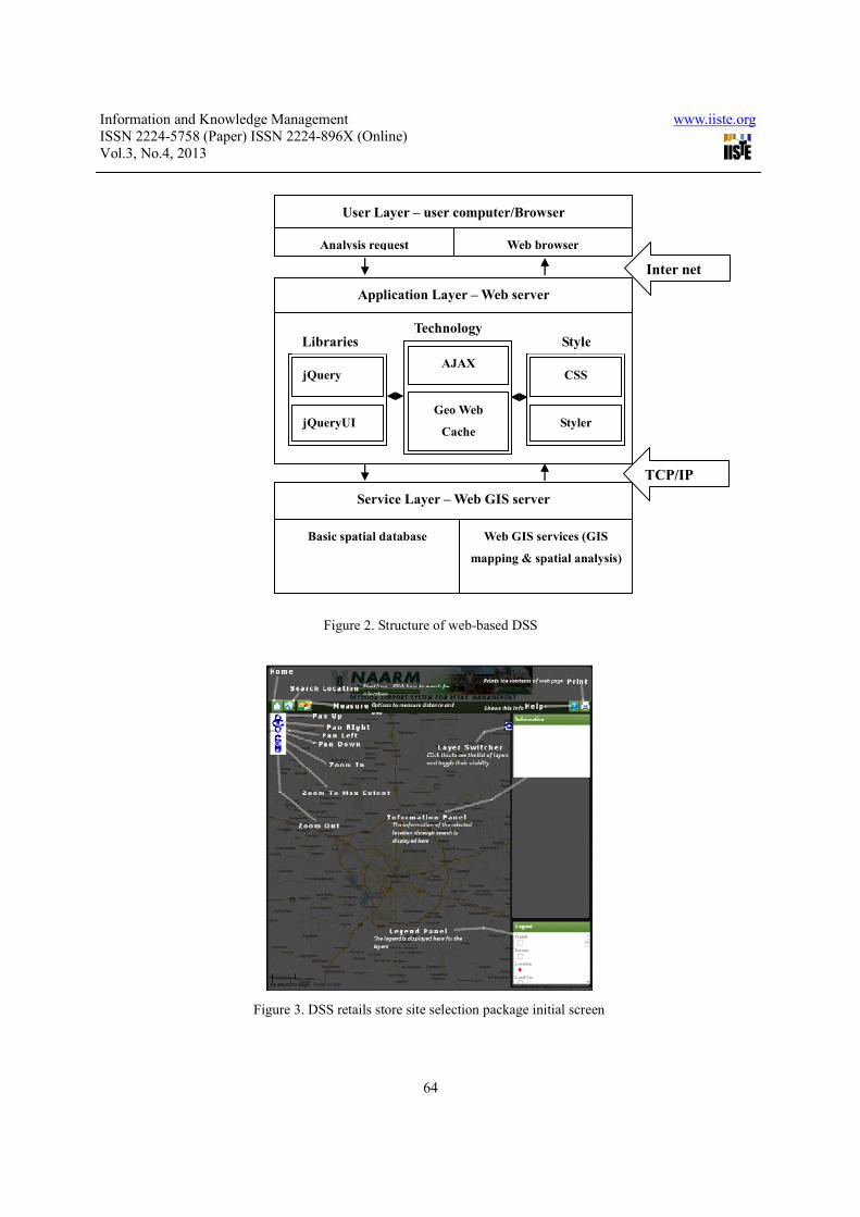
The DSS retail store site selection database structure is explained below (Figure 2).
In computing network design, user layer is described as a client and the other two layers within the network
which were used to store the comprehensive databases to ran more complicated applications are described as servers
(Lihua Zhao, 2005).
User layer:

Information and Knowledge Management www.iiste.org ISSN 2224-5758 (Paper) ISSN 2224-896X (Online) Vol.3, No.4, 2013
61
It is GUI interface for users,
Request sending – sending the request to the server about location wise or store wise analysis
Web browser – To receive and display the result of analysis from the server.
Application layer:
To meet the variety needs from the different users, application layer is designed to provide a comprehensive
analysis module. Here, internet is the connection link between the requests from client-side and result analysis
provided from service-side. After receiving a query from user, application layer will collect raw data from database
through service layer, analyze the content, gives the output in anattractive and appealing display to the user according
to the need-based queries.
Service layer:
This layer consist of two key components, one is relational database system and another is WebGIS module.
This relational database system stores and provides geo referenced datasets requested by the applications in the
application layer. The requested spatial analysis and geographical mapping tasks will be fulfilled by GIS module.
TCP/IP, a spatial language is used to link this layer with the application layer.
3. Results and Discussion
The spatial DSS described here is based on a GIS which offers functions for management, visualization and
elementary analysis of the spatial data involved. It is easy to update the database and by using GeoWebCache, a
unique feature of web GIS provides a fast accessing. The present study comprised different information layers viz.,
city limit, extended area, locality, sub-locality, road network, railway network, land use, ward, pincode and house
hold income of about 152 wards (election wards) and their sub wards in Greater Hyderabad Municipal Corporation
along with sampled ten major branded retail stores. Further, the geographic information (point features) of
corresponding 200 outlets of above sampled major retail stores was also added to the above database, that are
unevenly spread throughout the Hyderabad Metropolitan area.
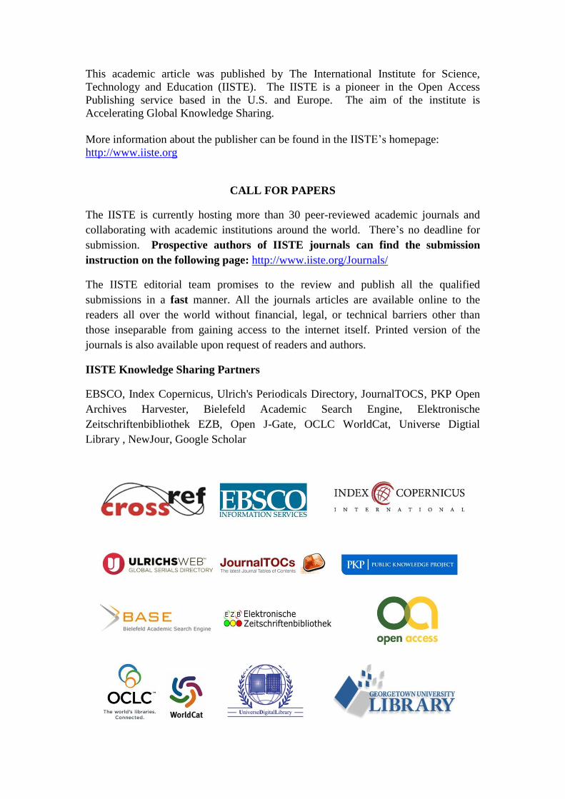
Before booting the main user-interface feature, the developed DSS provides an initial screen that gives the user a
bird’s eye view of all available controls and panels that flashes for six sec thereby helping the user to visualize about
the package (Figure 3).
The main user-interface page provides three panels viz., display panel (provides information in GUI mode),
information panel (provides reports in numerical format based on user queries) and legend panel (explains the
legends appeared in display panel). This user interface webpage also provides drop-down searching options of
locationwise and storewise retail store data with buffering area range of ~250 to 5000 Mts analytical option. This
page further provides distance measurement option between stores (point feature), length of road network (line
feature) and area (polygon feature) along with pan (up, down, right and left) and zoom options viz., zoom in, zoom
to maximum extend and zoom out, for better display comprehension. It also provides layer switcher which helps
user to change back end layer according to the user requisite. Thus, the user have option to choose the available back
end layers among hassle free public domains viz., google streets, google satellite, google hybrid, yahoo streets, yahoo
satellite, yahoo hybrid, bing streets etc., (Figure 4) without any restrictions. Using location-wise option, user can
select a location, sub location and buffer parameter that will provide geospatial information about the existing retail
stores within the sub locality and within the given buffer area limits along with corresponding wards information,
ward/subward wise house hold information, income category etc., (Figure 5).
By using store-wise search tool, location wise and buffer range (between ~250 to 5000 Mts) information about
specific store will be provided. Here, the output report will provide the information within that locality and within
the given buffer parameter range how many retail stores are existing along with wards information, ward-wise house
hold information, income category, etc. (Figure 6). Further, the measurement tools available will help to calculate
distance between two point features or line features or polygon features. The GUI output reports are printable either
in MS Excel or MS Word.

Information and Knowledge Management www.iiste.org ISSN 2224-5758 (Paper) ISSN 2224-896X (Online) Vol.3, No.4, 2013
62
4. Conclusion
The technical constraints involved in the utilization of GIS for retail site selection decision making have been
eroded over the last decade due to reduced cost of computing power, increased availability of digital map data,
availability of open source software’s with integration databases, and growth in use of the Internet for sharing
software and data (http://business.redlands.edu/grant/Logistics.pdf). However numerous opportunities to exploit
geographical relationships and constraints within retail site selection decision-making still exist. The present study is
a preliminary step for utilising the geospatial data for identifying the suitable retail site with limited time limit. This
study introduces a new, simple analysis tool that helps retail managers to explore alternative proposals for their major
retail developments thereby provides strategic decision making. Thus, the retail managers can go beyond regular
customary procedures by using GIS tools to integrate, visualize and analyze their options before making investment.
This study clearly reveals the fact that, WebGIS DSS can help integrate the spatial information and bridge human
analytical skills with their machine process ability. This WebGIS-based DSS provides the possibility to find a new
location for retail store using both spatial and attribute data analysis. However, the present DSS package can be
further improved by adding related data layers to get more accurate and feasible solutions for retail management.
Acknowledgement
First author gratefully acknowledges the financial support given by National Agriculture Innovation Project
(NAIP), New Delhi. The support provided by the Director, NAARM, Hyderabad for carrying out this study is
gratefully acknowledged.
References
A T Kearney’s Report, June (2008).
Ajax (programming), (accessed May 2012), http://en.wikipedia.org/wiki/Ajax_%28programming%29.
Apache HTTP Server, (accessed May 2012), http://en.wikipedia.org/wiki/Apache_HTTP_Server.
Avijit Sarkar. GIS Applications in Logistics: A Literature Review, (accessed May 2012),
http://business.redlands.edu/grant/Logistics.pdf.
Barry Berman and Joel R Evans. Trade areas and retail site selection (2010), In Retail Management: A Strategic
Approach, 11th Edition, Published by Prentice Hall.
Cascading Style Sheets, (accessed May 2012), http://en.wikipedia.org/wiki/Cascading_Style_Sheets.
Clarke, I Rowley J. (1995), A case for spatial decision-supprot system in retail location planning, International
Journal of Retail and Distribution Management, 3, Pp. 4-10.
Dhanabhakyam M, and Shanthi A. (accessed May 2012), Indian Retail Industry – Its growth, challenges and
opportunities,
http://www.fibre2fashion.com/industry-article/free-retail-industry-article/indian-retail-industry-its-growth-challenges
-and-opportunities/indian-retail-industry-its-growth-challenges-and-opportunities1.asp.
ESRI. (1995), Understanding GIS: The ARC/INFO Method, Geoinformation International, UK, Pp.1-2.
Fensel, D. and Bussler, C. (2002), The Web service modelling framework WSMF. Electronic Commerce Research
and Applications, 1(2), Pp. 113-137.
Geo Server, (accessed May 2012), http://geoserver.org/display/GEOS/Welcome.
Geo web cache, (accessed May 2012), http://geowebcache.org/.
Geographic Information Systems, (accessed May 2012),
http://gis.stackexchange.com/questions/25070/text-layer-styling-in-geoserver.
Goodchild. M.F. (1991), Geographic information systems, Journal of Retailing, 67(1), Pp. 3-15.
HTML, (accessed May 2012), http://en.wikipedia.org/wiki/HTML.
Indian Retail Industry, (accessed May 2012), http://business.mapsofindia.com/india-retail-industry/.

Information and Knowledge Management www.iiste.org ISSN 2224-5758 (Paper) ISSN 2224-896X (Online) Vol.3, No.4, 2013
63
ISPRS, (2006), Web GIS: Technology and its applications,.
JavaScript, (accessed May 2012), http://en.wikipedia.org/wiki/JavaScript#cite_note-ECMA-262-4.
JQuery UI, (accessed May 2012), http://en.wikipedia.org/wiki/JQuery_UI.
JQuery, (accessed May 2012), http://en.wikipedia.org/wiki/JQuery.
Khan, M. A. (1999), Restaurant franchising (2nd ed.). New York: John Wiley & Sons, Inc.
Khan, M. A. (1992), Restaurant franchising. New York: Van Nostrand Reinhold.
Lazarova, M and Angelova M. (2008), GIS Web services for distributed computing systems. Presented at
International Scientific Conference Computer Science’2008, Pp. 1010-1015.
LEVY and WEITZ. (2001), Retailing Management, 4th edition, McGraw-Hill, New York, Pp. 259.
Lihua Zhao, Hongwei Lu and Yousheng Yu. (December 2005), Designing and Implementing an Online
Web-GIS-based Decision Support System. Proceedings of the fifth International Conference on Electronic Business,
Hong Kong, 5-9, Pp. 117-124.
Michelsen Jr., M.W. (1994), GIS: guides marketers into future, business Marketing, 29.
PHP, (accessed May 2012), http://en.wikipedia.org/wiki/PHP#cite_note-1.
PostGIS, (accessed May 2012), http://en.wikipedia.org/wiki/PostGIS.
PostgreSql, (accessed May 2012), http://en.wikipedia.org/wiki/PostgreSQL#cite_note-4.
Sanjay Kumar and Suneeta Agrawal. (January, 2011), (accessed May 2012),GIS as a decision support system for
supply chain management, Geo Special World Forum, 18-21, Ref.No: PN-253.
http://www.geospatialworldforum.org/2011/proceeding/pdf/sanjayfullpaper.pdf.
Syed Nasirin and David F. Birks. (2003), DSS Implementation in the UK retail organizations: a GIS perpective,
Information & management, 40, 325-336.
Tayman, J.F. and Pol, L. (1995), Retail site selection and geographic information systems, Journal of Applied
Business Research, 11(2), Pp. 46-54.
Figure 1. Associated data layers considered for web-based DSS for new retail store site selection
Site Selection
City Limit
&
Extended
Existing
major retail
stores Info.
House hold
&
income Locality
&
Sub locality
Road & Rail
Network
Land use
Ward Info.
Information and Knowledge Management www.iiste.org ISSN 2224-5758 (Paper) ISSN 2224-896X (Online) Vol.3, No.4, 2013
64
Figure 2. Structure of web-based DSS
Figure 3. DSS retails store site selection package initial screen
Technology
User Layer – user computer/Browser
Analysis request Web browser
Application Layer – Web server
Service Layer – Web GIS server
Basic spatial database Web GIS services (GIS
mapping & spatial analysis)
Inter net
TCP/IP
jQuery
jQueryUI
AJAX
Geo Web
Cache
CSS
Styler
Libraries Style

Information and Knowledge Management www.iiste.org ISSN 2224-5758 (Paper) ISSN 2224-896X (Online) Vol.3, No.4, 2013
65
Figure 4. Main user-interface showing different panels a. display
panel b. information panel c. legend panel along with menu
options
Figure 5. Drop-down user query selection criteria giving search options location wise, store wise with buffer
parameter
a b
c

Information and Knowledge Management www.iiste.org ISSN 2224-5758 (Paper) ISSN 2224-896X (Online) Vol.3, No.4, 2013
66
Figure 6. Output of developed spatial DSS according to the chosen criteria
This academic article was published by The International Institute for Science,
Technology and Education (IISTE). The IISTE is a pioneer in the Open Access
Publishing service based in the U.S. and Europe. The aim of the institute is
Accelerating Global Knowledge Sharing.
More information about the publisher can be found in the IISTE’s homepage:
http://www.iiste.org
CALL FOR PAPERS
The IISTE is currently hosting more than 30 peer-reviewed academic journals and
collaborating with academic institutions around the world. There’s no deadline for
submission. Prospective authors of IISTE journals can find the submission
instruction on the following page: http://www.iiste.org/Journals/
The IISTE editorial team promises to the review and publish all the qualified
submissions in a fast manner. All the journals articles are available online to the
readers all over the world without financial, legal, or technical barriers other than
those inseparable from gaining access to the internet itself. Printed version of the
journals is also available upon request of readers and authors.
IISTE Knowledge Sharing Partners
EBSCO, Index Copernicus, Ulrich's Periodicals Directory, JournalTOCS, PKP Open
Archives Harvester, Bielefeld Academic Search Engine, Elektronische
Zeitschriftenbibliothek EZB, Open J-Gate, OCLC WorldCat, Universe Digtial
Library , NewJour, Google Scholar