GIS 550 Geospatial Structures and Web Services, Professor Hugh
17
GIS 550 Geospatial Structures and Web Services, Professor Hugh Devine, Spring 2012 Brenda McLuskie, bhmclusk, [email protected] Bhmclusk_Capstone.pdf , Due 3/23/12 GIS 550, Geospatial Data Structures and Web Services, Professor Hugh Devine, Spring 2012 Brenda McLuskie, [email protected] Bhmclusk_Capstone.pdf , Due 3/23/12 GIS550 Capstone Assignment: New River Gorge National River Proposed High Power Transmission Line Development Impact Study Objectives 1. Populatean ArcSDEgeodatabase from existing data. 2. Populate aPostgreSQL tabular database using data froma Microsoft Access database. 3. Create a web based mapping application that allows for the query and display of the database. 4. Create a web based mapping application that allows for interactive spatial analysis of the database. Deliverables A .pdf report that documents your application.Be sure to useappropriate headingsand include images and text that highlight your efforts. Documentationshould include: 1. The URL of your web application http://virginislands.cnr.ncsu.edu/bhmclusk_capstone/default.aspx 2. Screen capture(s)of your initial web mapping application.
Transcript of GIS 550 Geospatial Structures and Web Services, Professor Hugh

GIS 550
Geospatial Structures and Web Services, Professor Hugh Devine, Spring 2012
Brenda McLuskie, bhmclusk, [email protected]
Bhmclusk_Capstone.pdf , Due 3/23/12
GIS 550, Geospatial Data Structures and Web Services, Professor Hugh Devine, Spring 2012
Brenda McLuskie, [email protected] Bhmclusk_Capstone.pdf , Due 3/23/12
GIS550 Capstone Assignment: New River Gorge National River Proposed High Power Transmission Line Development Impact Study Objectives 1. Populatean ArcSDEgeodatabase from existing data.
2. Populate aPostgreSQL tabular database using data froma Microsoft Access database.
3. Create a web based mapping application that allows for the query and display of the database.
4. Create a web based mapping application that allows for interactive spatial analysis of the database. Deliverables A .pdf report that documents your application.Be sure to useappropriate headingsand include images and text that highlight your efforts. Documentationshould include:
1. The URL of your web application
http://virginislands.cnr.ncsu.edu/bhmclusk_capstone/default.aspx
2. Screen capture(s)of your initial web mapping application.
GIS 550
Geospatial Structures and Web Services, Professor Hugh Devine, Spring 2012
Brenda McLuskie, bhmclusk, [email protected]
Bhmclusk_Capstone.pdf , Due 3/23/12
GIS 550, Geospatial Data Structures and Web Services, Professor Hugh Devine, Spring 2012
Brenda McLuskie, [email protected] Bhmclusk_Capstone.pdf , Due 3/23/12
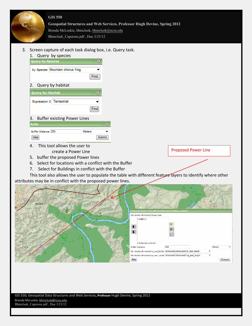
3. Screen capture of each task dialog box, i.e. Query task. 1. Query by species
2. Query by habitat
3. Buffer existing Power Lines
4. This tool allows the user to
create a Power Line 5. buffer the proposed Power lines 6. Select for locations with a conflict with the Buffer 7. Select for Buildings in conflict with the Buffer
This tool also allows the user to populate the table with different feature layers to identify where other attributes may be in conflict with the proposed power lines.
Proposed Power Line

GIS 550
Geospatial Structures and Web Services, Professor Hugh Devine, Spring 2012
Brenda McLuskie, bhmclusk, [email protected]
Bhmclusk_Capstone.pdf , Due 3/23/12
GIS 550, Geospatial Data Structures and Web Services, Professor Hugh Devine, Spring 2012
Brenda McLuskie, [email protected] Bhmclusk_Capstone.pdf , Due 3/23/12
8. Print tasks
Add pointers here
4. Screen capture of each task result. 1. Query of Species Result

GIS 550
Geospatial Structures and Web Services, Professor Hugh Devine, Spring 2012
Brenda McLuskie, bhmclusk, [email protected]
Bhmclusk_Capstone.pdf , Due 3/23/12
GIS 550, Geospatial Data Structures and Web Services, Professor Hugh Devine, Spring 2012
Brenda McLuskie, [email protected] Bhmclusk_Capstone.pdf , Due 3/23/12
2. Query for habitat type
GIS 550
Geospatial Structures and Web Services, Professor Hugh Devine, Spring 2012
Brenda McLuskie, bhmclusk, [email protected]
Bhmclusk_Capstone.pdf , Due 3/23/12
GIS 550, Geospatial Data Structures and Web Services, Professor Hugh Devine, Spring 2012
Brenda McLuskie, [email protected] Bhmclusk_Capstone.pdf , Due 3/23/12
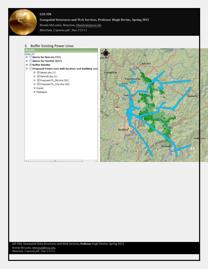
3. Buffer Existing Power Lines

GIS 550
Geospatial Structures and Web Services, Professor Hugh Devine, Spring 2012
Brenda McLuskie, bhmclusk, [email protected]
Bhmclusk_Capstone.pdf , Due 3/23/12
GIS 550, Geospatial Data Structures and Web Services, Professor Hugh Devine, Spring 2012
Brenda McLuskie, [email protected] Bhmclusk_Capstone.pdf , Due 3/23/12
4. One tool was used to create the new power line, 5. Buffer the proposed line 6. find locations 7. find buildings with conflict of the proposed Power Line.
Zoom to buildings

GIS 550
Geospatial Structures and Web Services, Professor Hugh Devine, Spring 2012
Brenda McLuskie, bhmclusk, [email protected]
Bhmclusk_Capstone.pdf , Due 3/23/12
GIS 550, Geospatial Data Structures and Web Services, Professor Hugh Devine, Spring 2012
Brenda McLuskie, [email protected] Bhmclusk_Capstone.pdf , Due 3/23/12
8. Print Results a.
.
GIS 550
Geospatial Structures and Web Services, Professor Hugh Devine, Spring 2012
Brenda McLuskie, bhmclusk, [email protected]
Bhmclusk_Capstone.pdf , Due 3/23/12
GIS 550, Geospatial Data Structures and Web Services, Professor Hugh Devine, Spring 2012
Brenda McLuskie, [email protected] Bhmclusk_Capstone.pdf , Due 3/23/12
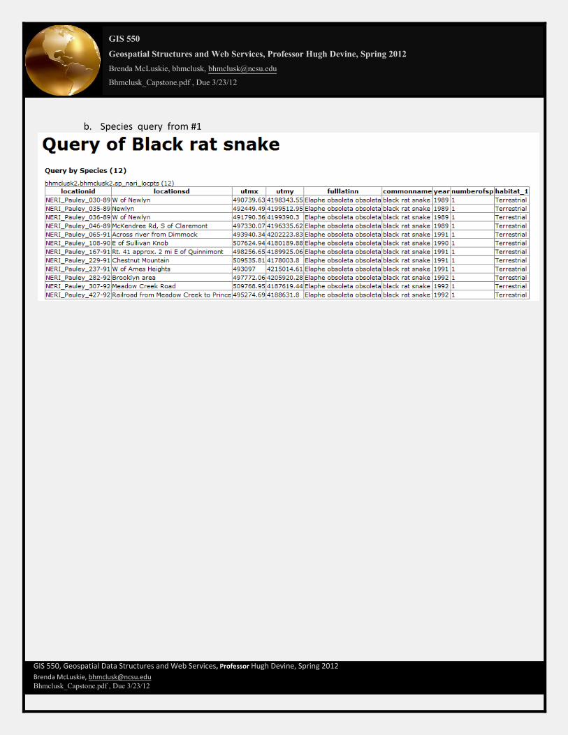
b. Species query from #1

GIS 550
Geospatial Structures and Web Services, Professor Hugh Devine, Spring 2012
Brenda McLuskie, bhmclusk, [email protected]
Bhmclusk_Capstone.pdf , Due 3/23/12
GIS 550, Geospatial Data Structures and Web Services, Professor Hugh Devine, Spring 2012
Brenda McLuskie, [email protected] Bhmclusk_Capstone.pdf , Due 3/23/12
c. Species in conflinct with the proposed Power Line #6 d. Buildings in conflict with the Proposed power Lines #7

GIS 550
Geospatial Structures and Web Services, Professor Hugh Devine, Spring 2012
Brenda McLuskie, bhmclusk, [email protected]
Bhmclusk_Capstone.pdf , Due 3/23/12
GIS 550, Geospatial Data Structures and Web Services, Professor Hugh Devine, Spring 2012
Brenda McLuskie, [email protected] Bhmclusk_Capstone.pdf , Due 3/23/12
5. Screen capture of each model used to create your geoprocessing tasks. a. Screen capture of Buffer

GIS 550
Geospatial Structures and Web Services, Professor Hugh Devine, Spring 2012
Brenda McLuskie, bhmclusk, [email protected]
Bhmclusk_Capstone.pdf , Due 3/23/12
GIS 550, Geospatial Data Structures and Web Services, Professor Hugh Devine, Spring 2012
Brenda McLuskie, [email protected] Bhmclusk_Capstone.pdf , Due 3/23/12
b. Screen Capture of Proposed Lines, Buffer, clip for Location and clip for Buildings
6. A screen capture of your Dia diagram.
GIS 550
Geospatial Structures and Web Services, Professor Hugh Devine, Spring 2012
Brenda McLuskie, bhmclusk, [email protected]
Bhmclusk_Capstone.pdf , Due 3/23/12
GIS 550, Geospatial Data Structures and Web Services, Professor Hugh Devine, Spring 2012
Brenda McLuskie, [email protected] Bhmclusk_Capstone.pdf , Due 3/23/12
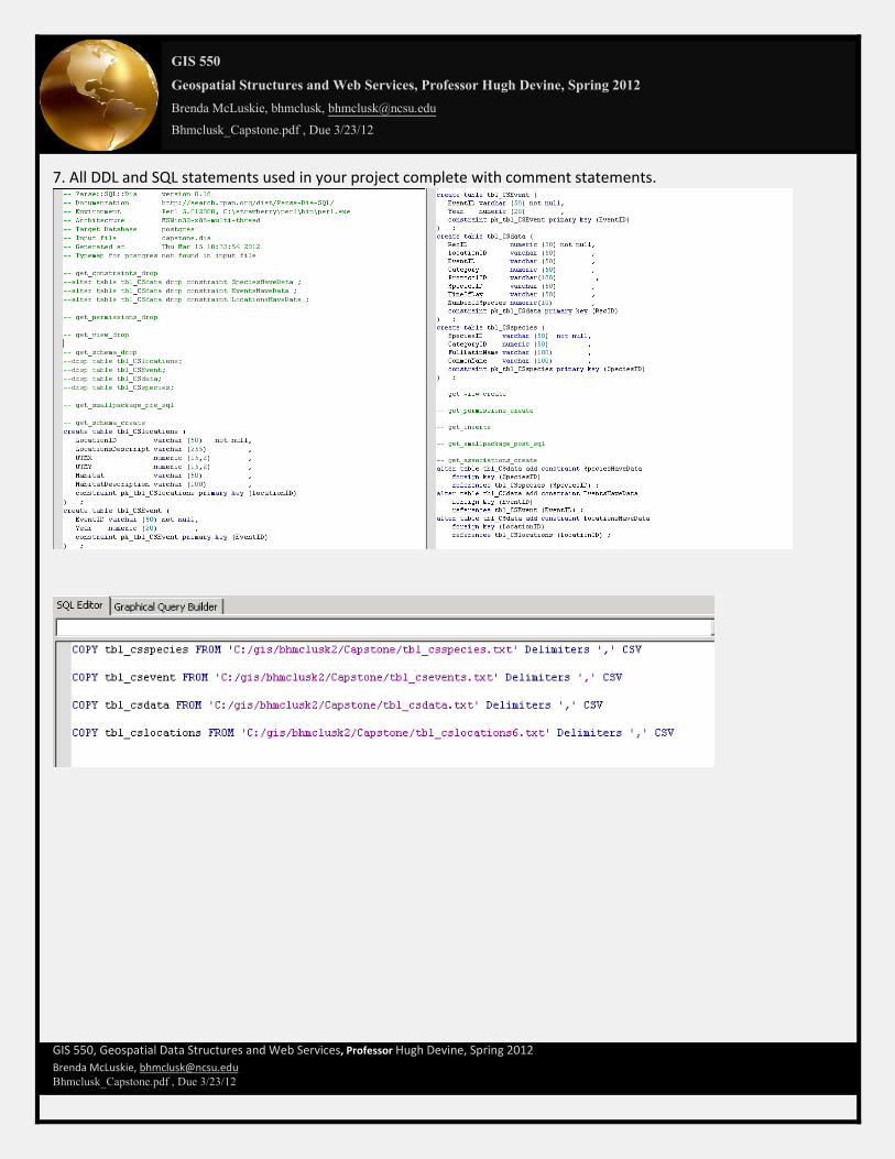
7. All DDL and SQL statements used in your project complete with comment statements.

GIS 550
Geospatial Structures and Web Services, Professor Hugh Devine, Spring 2012
Brenda McLuskie, bhmclusk, [email protected]
Bhmclusk_Capstone.pdf , Due 3/23/12
GIS 550, Geospatial Data Structures and Web Services, Professor Hugh Devine, Spring 2012
Brenda McLuskie, [email protected] Bhmclusk_Capstone.pdf , Due 3/23/12
8.

GIS 550
Geospatial Structures and Web Services, Professor Hugh Devine, Spring 2012
Brenda McLuskie, bhmclusk, [email protected]
Bhmclusk_Capstone.pdf , Due 3/23/12
GIS 550, Geospatial Data Structures and Web Services, Professor Hugh Devine, Spring 2012
Brenda McLuskie, [email protected] Bhmclusk_Capstone.pdf , Due 3/23/12
9. Screen capture(s) of your PostgreSQL schema and examples of each table populated with observation data. Schema

GIS 550
Geospatial Structures and Web Services, Professor Hugh Devine, Spring 2012
Brenda McLuskie, bhmclusk, [email protected]
Bhmclusk_Capstone.pdf , Due 3/23/12
GIS 550, Geospatial Data Structures and Web Services, Professor Hugh Devine, Spring 2012
Brenda McLuskie, [email protected] Bhmclusk_Capstone.pdf , Due 3/23/12
Table data
GIS 550
Geospatial Structures and Web Services, Professor Hugh Devine, Spring 2012
Brenda McLuskie, bhmclusk, [email protected]
Bhmclusk_Capstone.pdf , Due 3/23/12
GIS 550, Geospatial Data Structures and Web Services, Professor Hugh Devine, Spring 2012
Brenda McLuskie, [email protected] Bhmclusk_Capstone.pdf , Due 3/23/12
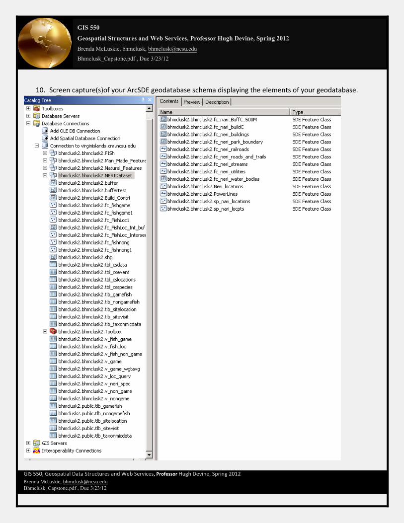
10. Screen capture(s)of your ArcSDE geodatabase schema displaying the elements of your geodatabase.

GIS 550
Geospatial Structures and Web Services, Professor Hugh Devine, Spring 2012
Brenda McLuskie, bhmclusk, [email protected]
Bhmclusk_Capstone.pdf , Due 3/23/12
GIS 550, Geospatial Data Structures and Web Services, Professor Hugh Devine, Spring 2012
Brenda McLuskie, [email protected] Bhmclusk_Capstone.pdf , Due 3/23/12
Thank you very much for allowing me extra time to complete this project. I had two major problems that had to be resolved before this project could be completed.
1. I mistakenly used Intersect instead of Clip in my models. This caused the models to work incorrectly. I had a great deal of difficulty identifying this issue because of the problem described below. 2. Internet Information Services were not installed correctly to run the ArcGIS Manager. I am unsure why ISS
was required . I identified the issue in http://help.arcgis.com/en/arcgisdesktop/10.0/help/index.html#//000400000029000000 . This caused the application to not update the server log, outputs, not allow the printing of tables, not allow query of output table and general mayhem. Once I installed the IIS services including the application development features this software works great. My output tables now display features, my display is now showing correctly, and the print tables’ capability now works. I am unclear exactly what Service is the key one that is required but I installed everything and the problem is resolved.
3. For future notice ISS services are also needed for Open Geo Services to run. Thanks again Brenda McLuskie