GIFTS FROM THE WAVES
66
JOHNSTONE CENTRE OF PARKS, RECREATION AND HERITAGE REPORT Nº 23 GIFTS FROM THE WAVES A case of marine transport of obsidian to Nadikdik Atoll and the occurrence of other drift materials in the Marshall Islands by Dirk H.R. Spennemann ALBURY 1996
Transcript of GIFTS FROM THE WAVES

JOHNSTONE CENTRE OF PARKS,RECREATION AND HERITAGE
REPORT Nº 23
GIFTS FROM THE WAVESA case of marine transport of obsidian to Nadikdik Atoll
and the occurrence of other drift materials in the Marshall Islands
byDirk H.R. Spennemann
ALBURY 1996

© Dirk H.R. Spennemann, Albury (NSW Australia) 1996All rights reserved. The contents of this study are copyright in all countries subscribing to the Berne Convention.No parts of this book may be reproduced or transmitted in any form or by any means, electronic or mechanical,including photocopying, recording or by any information storage and retrieval system, without the writtenpermission of the author, except where permitted by law.
Cataloguing–in–Publication Data
Spennemann, Dirk H.R. (Dirk Heinrich Rudolph), 1958—Gifts from The Waves. A case of marine transport of obsidian to Nadikdik Atolland the occurrence of other drift materials in the Marshall Islands. — Albury,NSW.: Charles Sturt University, The Johnstone Centre of Parks, Recreation andHeritage, 1995.1 v., ill., maps.—(Report / The Johnstone Centre for Parks, Recreation and Heritage)Bibliography.ISBNDDC 363.6909941. Archaeology – Trade – Obsidian. 2. Geology – Obsidian – Marshall Islands.3. Vulcanology – Pumice – Marshall Islands. 4. Marshall Islands – Ethnography– Material Culture. 5. Marshall Islands – Geography – Nadikdik Atoll. 6. Mar-shall Islands – Geology – Obsidian. 7. Marshall Islands – Geomorphology –Nadikdik Atoll. 8. Oceanography – Drift material – Marshall Islands.I. The Johnstone Centre for Parks, Recreation and Heritage. II. Title. III. Series
Editorial Note to the PDF editionThis file was converted to PDF in June 2004As a result of changed in fonts available to the computer used, minor variations may occurbetween the original printed version and this digital copy. These variations were unavoidable

Page iii
CONTENTS ............................................... III
PREFACE ....................................................VAcknowledgments.. . . . . . . . . . . . . . . . . . . . . . . . . . . . . . . . . . . . . . . . . . . . . v
INTRODUCTION......................................... 1Geography and Geology....................................... 3
THE PUMICE-CUM-OBSIDIAN ................ 5
NADIKDIK ATOLL..................................... 8Description of Nadikdik ....................................... 8Overview of Nadikdik’s History........................... 16The Typhoon of 1905........................................ 19
ORIGIN OF THE PIECE OF PUMICE .... 22Ocean Current Patterns in the Marshalls Area......... 22Dispersal of Pumice during volcanic eruptions ....... 25Similar occurrences........................................... 27
Cocos/Keeling .. . . . . . . . . . . . . . . . . . . . . . . . . . . . . . . . . . . . . . . . . . . . . . . 27Koil Island, Shouten Islands, PNG. .. . . . . . . . . . . . . . . . . . . . . . 27Bikini. . . . . . . . . . . . . . . . . . . . . . . . . . . . . . . . . . . . . . . . . . . . . . . . . . . . . . . . . . . 27Oahu... . . . . . . . . . . . . . . . . . . . . . . . . . . . . . . . . . . . . . . . . . . . . . . . . . . . . . . . . . . 27
Sourcing the Obsidian ....................................... 28
EXTRANEOUS MATERIALS IN THEMARSHALLS......................................... 32
Soil ............................................................... 32Volcanic stones................................................ 34
Traditional uses .. . . . . . . . . . . . . . . . . . . . . . . . . . . . . . . . . . . . . . . . . . . . . . 34
Pumice........................................................... 36Traditional uses .. . . . . . . . . . . . . . . . . . . . . . . . . . . . . . . . . . . . . . . . . . . . . . 38
Driftwood........................................................ 40Traditional uses .. . . . . . . . . . . . . . . . . . . . . . . . . . . . . . . . . . . . . . . . . . . . . . 42
Canoe hulls and drift voyages.............................. 43Modern drift material ......................................... 47
Modern uses .. . . . . . . . . . . . . . . . . . . . . . . . . . . . . . . . . . . . . . . . . . . . . . . . . . 47
IMPLICATIONS ........................................ 48
BIBLIOGRAPHY ....................................... 50
Contents

Page v
Preface
The oceanic dispersal of plants and animals has been the focus of some studies ever sinceorganised natural history started in the Pacific, and the dispersal by sea rafting has been givendue consideration. The find of drift materials is a common occurrence on the Pacific Islands,but in most cases the origin of the material is equivocal. Thus while the principle is knownand documented at length, there is a need to document those occasions where positive proofof origin can be furnished.This document discusses a piece of pumice with a chunk of obsidian attached found onNadikdik Atoll in the southern Marshall Islands, and places it into the context of other driftmaterial
Acknowledgments
While the fieldwork data were collected between 1990 and 1992, the bulk of the report waswritten after the author’s tenure as the Republic of the Marshall Islands Deputy HPO hadended and the author had taken up a lectureship at Charles Sturt University, Albury, NSW.I am indebted to Dr. Steve Simon, Republic of the Marshall Islands Independent NationwideRadiological Survey for support in conducting the fieldwork. Part of the fieldwork leading tothe discovery of the obsidian-cum-pumice object described in this paper was funded by theSouth Pacific Cultures Fund, Canberra (Australia), the financial assistance of whichgratefully acknowledged.Finally, I am indebted to Wal Ambrose (Division of Archaeology and Natural History,RSPAS, ANU) who conducted the trace element analysis of the obsidian component.

Page 1
Introduction
Many, Central Pacific island cultures of Micronesia and Polynesia do not have access tosharp stone implements for want of stone raw material which can be easily flaked, such assilex, chert or obsidian. The geological nature of the islands, mainly coral reefs and raisedlimestone islands precludes the occurrence of such material. Where present, igneous rocksuch as basalt was exploited for adze manufacture, but again, the material was not suitable forsmall artefacts. It is little wonder then that flakeable materials were traded over largedistances. Obsidian, a volcanic glass, is such a material. Because it is the most homogeneous,obsidian is the most flakeable of all materials available to Pacific Island populations short ofusing totally homogenous artificial glass, such as bottle glass.The Lapita culture has attained world fame for its long distance trade of obsidian. Flakes ofobsidian sourced to their original outcrops largely in the Bismarck Archipelago off NewGuinea have frequently been used as evidence of long-distance transport of items and ideas.In some instances obsidian outcrops could be identified 2000 km away from thearchaeological sites in island Melanesia where the flakes were found (see Allen 1984; Allen& Bell 1988; Ambrose 1976; 1978; Ambrose & Green 1972; Ambrose et al. 1981; Bird etal. 1981; Green 1978; 1979; 1982; Kirch 1988a; 1988b; Poulsen 1987; Smith 1974; Smithet al. 1977; Spriggs 1984). In addition, some Talasea obsidian has been found on Sabah inBorneo, some 2000 km to the northwest (Bellwood & Koon 1989). It has been argued in allcases that the obsidian has been traded. In the conceptual framework archaeologists havealways assumed that since obsidian is heavier than water it does not float and eo ipso had tobe transported by people to their destination.This brief report discusses a rather large piece of obsidian attached to an even larger piece ofpumice, which at one point in the past drifted into the waters of the Marshall Islands and wasdeposited on an island of Nadikdik Atoll. The finding that there is an option how obsidiancan actually float is bound to shatter this innocent assumption that all obsidian had to besourced by people. The increasing number of raw material sourcing studies in the Pacificarchaeologist tends to gloss over the fact that accidental transport is in fact possible. Drift-wood is a common occurrence on many islands. This report shall not argue a case ofaccidental transport over intentional transport, but shall act as a cautionary tale. The paperalso summarises the data available on extraneous materials encountered on the atolls of theRepublic of the Marshall Islands and their implications.

GIFTS FROM THE WAVES—CASES OF MARINE TRANSPORT
Page 2
.
12
10
8
6
4
14
16
18
2
20
166 168 170164162160 172 174
NORT
H
0 300
nautical miles
MejitAilinginae
Kwajalein
Maloelap
Wotje
Erikup
Aur
Likiep
Ebon
Eneen-Kio
Bokak
Bikar
UtrikEnewetak Bikini Ronglap Rongrik
Taka
Jemo Ailuk
Wotho
Ujelang
UjaeLae
LibNamu
Ailinglaplap
NamdrikKili
JaluitNADIKDIK
Mile
Arno
JabatMajuro
Figure 1. Map of the Marshall Islands, showing the location of Nadikdik Atoll.

GIFTS FROM THE WAVES—CASES OF MARINE TRANSPORT
Page 3
Before we look at the piece of pumice and obsidian itself, let us briefly look at the geographyand geological make-up of the atolls making up of the Marshall Islands.
Geography and Geology
The Marshall Islands (Aelon Kein Ad), comprising 29 atolls and 5 islands, are located in thenorth-west equatorial Pacific, about 3790km west of Honolulu, about 2700km north of Fijiand 1500km east of Ponape. With the exception of the two northwestern atolls, Enewetak andUjelang, the Marshall Islands are arranged in two island chains running roughly NNW toSSE: the western Ralik Chain and the eastern Ratak Chain (figure 1). Majuro Atoll, with itsclose neighbour, Arno Atoll, is located on the northern margin of the southern group of atollsof the Ratak Chain (or Ratak-rak). Not counting the five islands, Jemo, Jabwat, Kili, Lib andMejit, the atolls of the Marshall Islands range from very small, with less than 3.5km2, such asNadikdik (Knox) Atoll to very large. With 2,173km2 lagoonal area, Kwajalein Atoll has thedistinction to be the atoll with the World’s largest lagoon.The Marshall Islands consist of atolls and raised islands. In his initial classification of atollformation, Charles Darwin distinguished between three stages: Fringing reef, barrier reef andatoll. In the substantially more detailed typology of atoll development drawn up by Tayama(1952, quoted after Thomas 1967), eight forms of reefs can be distinguished, ranging indevelopment from apron reefs to table reefs. Following Darwin's subsidence theory, the atollsof the Marshall Islands were initially formed as apron reefs and fringing reefs aroundvolcanic islands, similar to Ponape; increased subsidence of the volcanic cone and ongoingreef growth led to the development of almost barrier reefs or barrier reefs, such as Palau;Final subsidence led to the development of almost atolls, such as Chuuk Lagoon. Darwin'ssubsidence theory could be proven right during the deep-drilling experiments undertaken onEnewetak Atoll in conjunction with the nuclear testing programme. While the earlier coresdrilled on Bikini still encountered a limestone formation at 775 metres (Ladd et al. 1948),while the two cores drilled at Enewetak encountered a volcanic base at 1271 and 1405 metresrespectively (Emery et al. 1954; Tracey & Ladd 1974).The atolls of the Marshall Islands are aligned along two chains, Ralik and Ratak. Bathometricmaps show that there is also an abundance of seamounts (guyots), some of which reachalmost to the surface, such as Keats Bank east of Arno Atoll. Most of these guyots arealigned along the same axes as the Ralik and Ratak Chains, so that these bathometric featuresas a whole have recently been termed Ralik Ridge and Ratak Ridge (see Hein et al. 1988, p.256). The reefs in the Marshall Islands consist of fully developed atolls, such as Majuro,almost table reefs, such as Wake/Eneen-Kio, and table reefs, such as Mejit (see Menard1986, p. 36; 186 ff.; Scott & Rotondo 1983).Coral growth, and correspondingly reef width, is most vigorous in areas in the generaldirection of prevailing winds, currents and waves. Since the Marshall Islands are in the zoneof the northeastern tradewinds, with predominant wind and swell direction from the southeast,the zone of most reef growth is the southern and eastern side. Conversely, deep passesthrough the reef platform occur most frequently on the leeward side of the atolls. Thus onmost atolls there are several passes, which are located in the west and northwest of the atoll.The islets and islands making up the supra-tidal area of the atolls comprise of unconsolidated

GIFTS FROM THE WAVES—CASES OF MARINE TRANSPORT
Page 4
sediment with the exception of the islet's fringe where beachrock can have formed at thefreshwater lens discharge zone.At no point in the Republic of the Marshall Islands is volcanic or sedimentary rock other thanlimestone or beachrock (=cemented sand) accessible at the surface. In addition, no sources ofobsidian or other flakeable material exist on the islands of the Marshallese atolls. Thus theoccurrence of any volcanic material is of substantial interest to the academic community.

Page 5
The Pumice-cum-Obsidian
This section describes the piece of pumice-cum-obsidian under discussion. The item underscrutiny is a large piece of pumice with a slab of obsidian attached to one side (figure 2).Stone (1933) uses the following terminology for ejecta: Boulders or blocks (≥256mm);Cobbles (64-256mm); Pebbles (4-64mm); Lapilli (2-4mm); and Ash (≤2mm). Based on thisterminology the piece of pumice encountered would be classified as a boulder.The piece is of oblong-rounded shaped with rounded and worn edges of the pumice and aflattish, smooth bottom at the obsidian side. The pumice side shows some flaking, with wornedges, suggesting that the flaking occurred early on and that subsequent erosion took place.The obsidian section consists of a continuous slab with a one major groove running to adepth of approximately one third of the thickness of the obsidian. The piece shows no marinegrowth in form of barnacles, algae or other depositions, suggesting that the piece wassuspended in seawater only for a comparatively short time. The piece showed some fungalgrowth at the pumice surface, consistent with the fungal and algal growth encountered oncoral boulders and rubble which had rested in shaded supra-tidal localities for some time.The pumice is of dark grey to blackish colour and medium to coarse grained, with air cavitiesranging in size from 0.5mm to 15mm. On the whole it is dense and compact. Compared toother pumice seen in the Marshalls, this piece belongs to the hard type, suitable forwoodworking, but too hard (‘sharp’) to be used for personal hygiene. The piece of airregular shape and hence irregular dimensions. It measures about 32 cm in length, 22 cm inwidth and 20 cm in thickness. The slice of obsidian is about 22cm long, 5cm wide and 4-5cmthick. About 3.5 cm of this thickness would yield high quality obsidian suitable for flaking.The piece of pumice-cum-obsidian under discussion was found in June 1991 during anarchaeological reconnaissance survey of Nadikdik Atoll, south of Mile Atoll. It was foundwith the side bearing the obsidian resting on the ground. If suspended in water, that side, too,would point downwards. It is clear from its position in relation to the shoreline, that it floatedinland and that it had been deposited there by wave action. Given the position it rested, thepresence of obsidian would not have been noticed, had not the extra-ordinarily large size ofthe pumice attracted the author’s attention. Once discovered other larger pieces of pumicefound in the vicinity were also scrutinised for the occurrence of obsidian, but none was noted.

GIFTS FROM THE WAVES—CASES OF MARINE TRANSPORT
Page 6
Figure 2. Photographs showing the piece of pumice-cum-obsidian found on Nadikdik Atoll.

GIFTS FROM THE WAVES—CASES OF MARINE TRANSPORT
Page 7
Dating the deposition of the piece of pumice on Nadikdik Atoll is complicated. It can only beprovided in kind of a terminus post quem.In the following section the geography of the island and the historical data available to us willbe reviewed. As will be shown, the island was ravaged by a typhoon in 1905 and a depositionafter that typhoon event is very likely.
Figure 3. Map of Nadikdik Atoll showing the overall length of the major islets.(after: USHO Chart 6003,North Pacific Ocean, Marshall Islands, Mile Atoll (Northeastern Part), Original scale 1:36,640. Originaldrawn up September 1944; map with additions by the author).
Page 8
Nadikdik Atoll
Nadikdik Atoll, in the literature also known as “Knox Atoll”, forms the southernmost atollin the (eastern) Ratak Chain and is located at 5°45' North and 172°10' East. The atollcomprises 18 islets and sand cays with a combined land area of only 0.98 km2 which makesit the 27th largest atoll in the Marshall Islands (of 33; not counting Eneen-Kio), enclosing alagoon area of 3.42 km2 (29th largest lagoon). The atoll is located off the southeastern tip ofMile Atoll, separated from the latter by “Klee Passage”, a 3 nm wide strait. Nadikdik andMile are supported by the same submarine mountain and are connected at the 60 –70 footisobath.Nadikdik Atoll is covered on sheets “8639 IV NE Chirubon NE” and “8639 IV SEChirubon SE” which are part of a series of maps drawn up by the U.S. Army Map Servicein 1946 (Map AMS Series W861 Scale 1:25,000)., which wased on U.S. Navy aerialphotography flown in 1944 (same map also issued in 1947).. The atoll comprises of a seriesof small islands on the western reef platform with a cluster of islets in the north and a largerisland (Nadikdik) in the south and the islet of Nariktal in the centre. On the eastern,'weatherward' reef platform there are only a few scattered islets, too small and too exposedand thus unfit for permanent human habitation (figure 3). The northern part of the atoll withthe island where the pumice was found is reproduced in detail in figure 4. The ocean side ofthe small northwestern islets showed a well-defined storm beach with coral rubble sortingeven at the leeward shore (figure 5) and a succession of accretion ridges demarcated bywashed-up coconuts in various states of germination and growth (figure 6) consolidating thegained land. On the island of Aelon-eo a number of successive beach ridges can be followedinto the interior of the island (figures 7 & 8) showing that this process has been occurringfor some time.
Description of Nadikdik
Nadikdik Atoll is one of the few atolls of the Marshall Islands which does not possess apassage through the reef. Access is only possible by boat through the surf on the leewardside (which was the method chosen by the survey) or by passing at high tide over the reefinto the lagoon. The lagoon is very small and was found to be very shallow. Large patches ofthe lagoonal bottom fall dry at low tide (figure 9).
GIFTS FROM THE WAVES—CASES OF MARINE TRANSPORT
Page 9
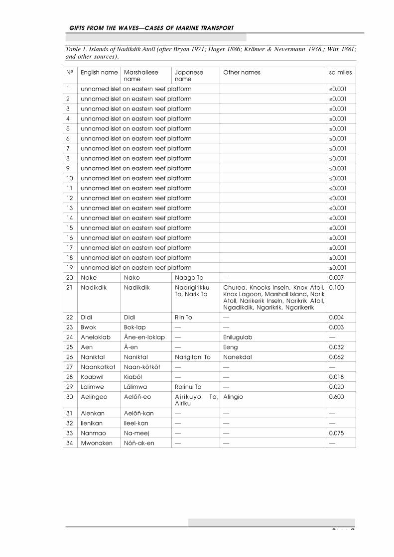
Table 1. Islands of Nadikdik Atoll (after Bryan 1971; Hager 1886; Krämer & Nevermann 1938,; Witt 1881;and other sources).
Nº English name Marshallesename
Japanesename
Other names sq miles
1 unnamed islet on eastern reef platform ≤0.001
2 unnamed islet on eastern reef platform ≤0.001
3 unnamed islet on eastern reef platform ≤0.001
4 unnamed islet on eastern reef platform ≤0.001
5 unnamed islet on eastern reef platform ≤0.001
6 unnamed islet on eastern reef platform ≤0.001
7 unnamed islet on eastern reef platform ≤0.001
8 unnamed islet on eastern reef platform ≤0.001
9 unnamed islet on eastern reef platform ≤0.001
10 unnamed islet on eastern reef platform ≤0.001
11 unnamed islet on eastern reef platform ≤0.001
12 unnamed islet on eastern reef platform ≤0.001
13 unnamed islet on eastern reef platform ≤0.001
14 unnamed islet on eastern reef platform ≤0.001
15 unnamed islet on eastern reef platform ≤0.001
16 unnamed islet on eastern reef platform ≤0.001
17 unnamed islet on eastern reef platform ≤0.001
18 unnamed islet on eastern reef platform ≤0.001
19 unnamed islet on eastern reef platform ≤0.001
20 Nake Nako Naago To — 0.007
21 Nadikdik Nadikdik NaarigirikkuTo, Narik To
Churea, Knocks Inseln, Knox Atoll,Knox Lagoon, Marshall Island, NarikAtoll, Narikerik Inseln, Narikrik Atoll,Ngadikdik, Ngarikrik, Ngarikerik
0.100
22 Didi Didi Riin To — 0.004
23 Bwok Bok-lap — — 0.003
24 Aneloklab Ãne-en-loklap — Enilugulab —
25 Aen Ã-en — Eeng 0.032
26 Naniktal Naniktal Narigitani To Nanekdal 0.062
27 Naankotkot Naan-kõtkõt — — —
28 Koabwil Kiabõl — — 0.018
29 Lolimwe Lãlimwa Rorinui To — 0.020
30 Aelingeo Aelõñ-eo Air ikuyo To,Airiku
Alingio 0.600
31 Alenkan Aelõñ-kan — — —
32 Ilenlkan Ileel-kan — — —
33 Nanmao Na-meej — — 0.075
34 Mwonaken Nõñ-ak-en — — —

GIFTS FROM THE WAVES—CASES OF MARINE TRANSPORT
Page 10
Figure 4. Enlarged section of the northern part of Nadikdik Atoll (after: AMS 1946a), Original scale1:25,000. The grid is set out in 1km squares.

GIFTS FROM THE WAVES—CASES OF MARINE TRANSPORT
Page 11
Figure 5. The western, leeward shore of Nadikdik Atoll.

GIFTS FROM THE WAVES—CASES OF MARINE TRANSPORT
Page 12
Figure 6. Storm beach atNadikdik showing thedeposition of floated coconutsin two stages of ger-mination/growth, as well as afew not yet germinated nuts infront.,
This is especially true for the northern part of the atoll, which has a number of smallmangrove patches and evidence of new and ongoing colonisation. Worth noting are also thelarge Porites sp. microatolls, likewise located in the northern part of the atoll.The configuration of the atoll is such that the shallow lagoon lacks a pass and the wave actionon the reef so strong that it does not permit the entry of a vessel other than a flat-bottomedlaunch at high tide (and from the protected western shore). Thus all ships normally hove to atthe leeward shore while people are ashore. Even on quiet days the atoll experiences a surf(figure 10), and landing on the atoll is not always possible.The survey of Mile and Nadikdik Atolls was conducted in conjunction with the IndependentNationwide Radiological Survey in June 1991. All islands on Nadikdik Atoll, with theexception of Nadikdik itself, were found to be uninhabited. On the latter a single householdwas encountered which had been established comparatively recently.

GIFTS FROM THE WAVES—CASES OF MARINE TRANSPORT
Page 13
Figure 7. Island of Aelon-eo, Nadikdik Atoll. Photograph showing the ground cover which is very similar tothat of Aelon-kan. Note the beach accretion ridges.
Figure 8. Island of Aelon-eo, Nadikdik Atoll. Photograph showing the ground cover which is very similar tothat of Aelon-kan. Note the beach accretion ridges.

Pag
e 1
4
Figu
re 9
. Pan
oram
ic v
iew
of th
e la
goon
of N
adik
dik
Atol
l at l
ow ti
de, l
ooki
ng e
ast.
(Pho
to ta
ken
from
Ael
on-e
o). T
he sm
all i
slets
in th
e ba
ckgr
ound
del
inea
ted
the
east
ern
fring
e of
the
reef
pla
tform
. Not
e th
e sc
atte
r of c
oral
bou
lder
s and
rubb
le o
n th
e sa
ndy
botto
m, i
ndic
ativ
e of
stor
m d
epos
its a
nd c
ontin
ued
high
ene
rgy
wave
act
ion
wash
ing
acro
ss th
e ea
stern
ree
f pla
tform

Page 15
Figure 10. The leeward shore of Nadikdik showing the shingle beach and a vessel hoving to.
Like the others, the island of Aelon-kan, a small island northeast of Aelon-eo, was surveyedon foot. No archaeological or historical sites were found. This is in keeping with theenvironmental destruction wrought by the 1905 typhoon. Unless systematic coring or testinghas been carried out it cannot even be deemed certain that any of the sediment layers predatethe typhoon. The vegetation encountered on the island of Aelon-kan comprised of a coastalbroadleaf forest with a fringe of coconut (Cocos nucifera). The majority of the vegetationwas largely made up from Scaevola taccada, and some coconuts (Cocos nucifera) as well asGuettardia speciosa. In addition some Morinda citrifolia, Pemphis sp., and Luminitzeralittorea were encountered. The ground cover was sparse, with Polypodium scolopendria,sprouted Cocos nucifera, and Nephrolepsis sp. predominant.Animals seen on Aelon-kan during the 1991 survey were the blue-tailed skink (Emoiacyanura), a small lengthwise-banded skink (Emoia arnoensis ?) and large tree geckos(Gehyra oceanica). Especially abundant were large red land crabs and hermit crabs. Somechewed fallen coconuts gave evidence for the presence of rats, although none were seen tofurnish positive identification as to species.At the time of the survey the lagoon was populated with a large number of small (0.3 to 0.7mlong) black-tipped reef sharks (Carcharhinus melanopterus) which were very curious andfollowed people walking on the lagoonal beach.The only non-floatable artefacts found during the archaeological survey of the westernislands of Nadikdik Atoll were aerial bombs (figure 11), either Japanese practice bombs orthey may have been dropped in an attack on the atoll of Mile, which had been a majorJapanese military base during the war (cf. Spennemann 1991; USSBS 1947).During the survey a great deal of drift material ranging from large driftwood trees and cutdriftwood logs to fishing net floats of all kinds and sizes, as well as glass and plastic bottles,

GIFTS FROM THE WAVES—CASES OF MARINE TRANSPORT
Page 16
and fluorescent light tubes were encountered along the shores. Although they wereconcentrated in a zone reaching about 5-10m from the high tide mark of both lagoonal andocean shores, individual pieces could be encountered up to 20-30m inland. In the main inlanddeposition zone also numerous pieces of pumice were seen, one of which was rather largeand stood out from the others because it had a large piece of obsidian attached to it.
Figure 11. Remains of aerial bombs found near Aelon-eo, Nadikdik Atoll. These bombs date to World WarII.

Page 17
Overview of Nadikdik’s History
Because Nadikdik was uninhabited for the most part of this century (see below), it does notfigure prominently in the geographic and ethnographic literature (see PIP 1943; 1956;OPNAV 1943; JICPOA 1943; Krämer & Nevermann 1938, p. 60-61). But even for theperiod before 1905 only very little is known about the history of Nadikdik as it attracted littleattention by Foreigners compared to neighbouring Mile.The atoll was first seen by Europeans on June 24, 1788, when the British transport Charlotteunder the command of Captain Thomas Gilbert and the transport Scarborough under thecommand of Captain William Marshall passed by en route from the newly founded Britishcolony at Port Jackson (Australia) to Canton in China. Land was sighted at 5°58’N and172°3’ E, and a canoe with 25 people came out to make contact and trade. Gilbert (1789, p.35-37) gives a description of the ongoings but provides no description of the atoll. Thevessels then sailed north passing several other atolls of the Ratak Chain in the process. Milewas apparently initially named Gilbert Island, while Nadikdik was named Marshall Island,after the names of the Captains. This was then changed and Mile became known as“Mulgraves islands”, while Nadikdik was named “Knox.”A number of British transports followed Gilbert’s and Marshall’s route and encounteredseveral atolls of the Marshall Islands (Hezel 1979, p. 114-115), even though Nadikdik seemsnot to have been encountered again. A possible exception is the British merchant ship Rolla,Captain John Cummings commanding, who en route from Port Jackson to Canton, on 30October 1803 encountered an island at 5°41’N 169°27”E, but could not land because ofheavy surf (Hezel 1979, p. 115).Nadikdik is also mentioned by the Russian Captain Victor S.Kromchenko, when he passedby in 1829 in the Helena and again in 1832 in the America (Hezel 1979). Again, no detailson the island have been provided.In early May 1841 the Wilkes Exploring Expedition passed through with the vesselsPeacock (Capt. Hudson) and Flying Fish under the command of Captain Knox (Hezel1979). The U.S. Exploring Expedition surveyed the atoll and provided a map, but did notland.In the mid 1870s, the atoll is described by James Lyle Young, a trader for Adolph Capellewith the following diary entry:
Knox Island is quite small, 1 mile in length, perhaps, without any lagoon and some 20 to 30inhabitants landing can be effected in smooth weather on the lee side. Coconuts and Pandanus.No fresh water. (Young 1877, p. 21; entry for 14 June 1876)
This description is possibly too dire, but is the most elaborate on hand. Significantly it comesfrom a trader, the only mariner who would bother landing there. In addition, in December1885 the whaler Fleetwing passed by (Langdon 1978; 1979), but again not much detail isknown.

GIFTS FROM THE WAVES—CASES OF MARINE TRANSPORT
Page 18
Figure 12. Map of Nadikdik Atoll as surveyed by Charles Wilkes in 1840 during the USS Exploringexpedition. The map has been edited for clarity with survey base lines removed. (after Ehrenberg et al1985).
One irooj of Mile, Langerik, owns the easternmost part of Mile and the entire Nadikdik Atoll.The atoll was visited by the German gunboat Eber in 1888, investigating an arson attackagainst a European trade station on Mile, in which Langerik was alleged to have beeninvolved. As the surf was too high to permit a landing, the Eber left without investigation.1
Nadikdik Atoll is traditionally reported as the atoll of the dead, the place where dead went andeither passed on to the land of the dead in the west, or fell into a deep hole. It unclear whetherthis tradition is an old one, or whether it has been created as a result of the enormous toll ofhuman life taken by the 1905 typhoon.
1 Kommandant S.M. Kreuzer Adler, Schrift über die Reise S.M. Kanonenboot Eber von Apia nach der Marshall
Gruppe und zurück, dated 22 November 1888. Contained in: Records of the German Admiralty, Series XII FileNo. PG/65070, XII.2.4.38 Entsendung von Kriegsschiffen nach Australien und den Südseeinseln. November1887 - Januar 1889. National Library of Australia, Canberra, Australia. Microfilm No. M 304.—It does notsem that the Germans evenf the district administrators annual reports and trip reports mentions a visit to theatoll.

GIFTS FROM THE WAVES—CASES OF MARINE TRANSPORT
Page 19
Figure 13. Tentatively reconstructed path of the cyclone of 1905. For details see text.1
According to Jeschke (1906) Nadikdik never had a permanent population, but was used as aseasonal fishing and copra collecting location by the people of Mile Atoll. Just before thetyphoon of 1905 (see below) Nadikdik had a (temporary?) population of about 60 to 80people. For most part of this century Nadikdik was uninhabited, but was occasionally visitedby people from Mile who came and stayed on a temporary basis to exploit the copra and fishresources of the island and who caught seabirds and turtles. 1 The reconstruction shown in figure 13 is an updated and substantially modified version of a map previously
published in the Cultural Resource Management Plan for Majuro Atoll (Spennemann 1990). The map is thesame as that produced for the review of the German disaster management actions following the 1905 typhoon(Spennemann in press)
2 The reconstruction shown in figure 13 is an updated and substantially modified version of a map previouslypublished in the Cultural Resource Management Plan for Majuro Atoll (Spennemann 1990). The map is thesame as that produced for the review of the German disaster management actions following the 1905 typhoon(Spennemann in press)
GIFTS FROM THE WAVES—CASES OF MARINE TRANSPORT
Page 20
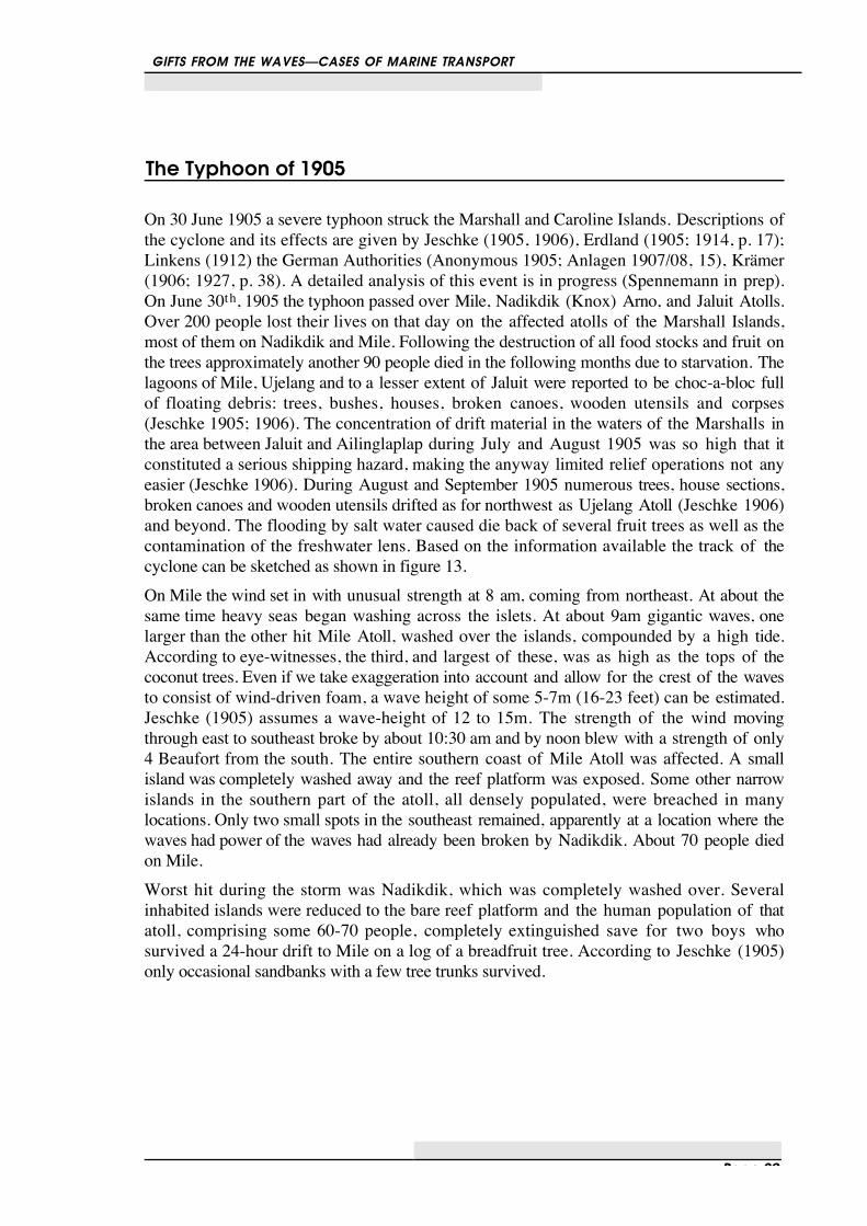
The Typhoon of 1905
On 30 June 1905 a severe typhoon struck the Marshall and Caroline Islands. Descriptions ofthe cyclone and its effects are given by Jeschke (1905, 1906), Erdland (1905; 1914, p. 17);Linkens (1912) the German Authorities (Anonymous 1905; Anlagen 1907/08, 15), Krämer(1906; 1927, p. 38). A detailed analysis of this event is in progress (Spennemann in prep).On June 30th, 1905 the typhoon passed over Mile, Nadikdik (Knox) Arno, and Jaluit Atolls.Over 200 people lost their lives on that day on the affected atolls of the Marshall Islands,most of them on Nadikdik and Mile. Following the destruction of all food stocks and fruit onthe trees approximately another 90 people died in the following months due to starvation. Thelagoons of Mile, Ujelang and to a lesser extent of Jaluit were reported to be choc-a-bloc fullof floating debris: trees, bushes, houses, broken canoes, wooden utensils and corpses(Jeschke 1905; 1906). The concentration of drift material in the waters of the Marshalls inthe area between Jaluit and Ailinglaplap during July and August 1905 was so high that itconstituted a serious shipping hazard, making the anyway limited relief operations not anyeasier (Jeschke 1906). During August and September 1905 numerous trees, house sections,broken canoes and wooden utensils drifted as for northwest as Ujelang Atoll (Jeschke 1906)and beyond. The flooding by salt water caused die back of several fruit trees as well as thecontamination of the freshwater lens. Based on the information available the track of thecyclone can be sketched as shown in figure 13.On Mile the wind set in with unusual strength at 8 am, coming from northeast. At about thesame time heavy seas began washing across the islets. At about 9am gigantic waves, onelarger than the other hit Mile Atoll, washed over the islands, compounded by a high tide.According to eye-witnesses, the third, and largest of these, was as high as the tops of thecoconut trees. Even if we take exaggeration into account and allow for the crest of the wavesto consist of wind-driven foam, a wave height of some 5-7m (16-23 feet) can be estimated.Jeschke (1905) assumes a wave-height of 12 to 15m. The strength of the wind movingthrough east to southeast broke by about 10:30 am and by noon blew with a strength of only4 Beaufort from the south. The entire southern coast of Mile Atoll was affected. A smallisland was completely washed away and the reef platform was exposed. Some other narrowislands in the southern part of the atoll, all densely populated, were breached in manylocations. Only two small spots in the southeast remained, apparently at a location where thewaves had power of the waves had already been broken by Nadikdik. About 70 people diedon Mile.Worst hit during the storm was Nadikdik, which was completely washed over. Severalinhabited islands were reduced to the bare reef platform and the human population of thatatoll, comprising some 60-70 people, completely extinguished save for two boys whosurvived a 24-hour drift to Mile on a log of a breadfruit tree. According to Jeschke (1905)only occasional sandbanks with a few tree trunks survived.

GIFTS FROM THE WAVES—CASES OF MARINE TRANSPORT
Page 21
Figure 14. Map of the Nadikdik Atoll indicating the impact of the 1905 typhoon (base map: USHO Chart6003, North Pacific Ocean, Marshall Islands, Mile Atoll (Northeastern Part., Original scale 1:36,640.Drawn up September 1944.
Wilkes's map allows up to compare the appearance of the island in 1840 (figure 12) with thatin 1946 (figure 14) and thereby assess the impact of the typhoon of 1905.1 Wilkes’ mapshows a near continuous island on the western side of the atoll, which is in keeping with thedeposition of sand and fine gravel in this part of the Marshalls, where all the main islands of 1 Note that Wilkes map as reproduced, had been drawn up to explain the method of his “running survey” and that,
therefore, the image was not checked for accurancy after it had been cut. The north arrow of the map is inverted.The image, as shown, in this report has been edited for clarity with all the survey lines, as well as other,insignificant textual information removed.

GIFTS FROM THE WAVES—CASES OF MARINE TRANSPORT
Page 22
the atolls are located in the west (cf. Arno, Majuro, Mile). The island has been broken up bythe typhoon-generated storm surge into a series of smaller islets with larger stretches of openreef platform. In addition, the islands at the northern and southern tip of the atoll have beenbroken up and substantially reduced. Over time, the islands in the north have accreted again.Likewise and islet in the centre of the eastern reef platform has been rebuilt. In its lee a largeisland, Nariktal, has formed on the western platform. The islands in the centre of the lagoonhave been eroded. On any atoll the lagoon acts as a sediment trap for all that loose coralrubble, gravel and sand generated at the windward shore and washed across the reefplatform.1 The atoll’s lagoon was small and could fill up reasonably quickly.The impact of cyclonic surge of the 1905 typhoon on the Nadikdik settlement is a goodexample why the piece of pumice-cum-obsidian could not have survived the typhoon event.Cyclonic surges tend to churn up the topsoil and suspend the sediment. The floatable matteris washed off (Spennemann 1992), while the material heavier than water is eventuallyredeposited (cf. Spennemann 1986) and only the very heavy material remains in situ. The1918 typhoon on Majuro Atoll stripped much of the narrow island of Ajeltake of its topsoilwhich was dumped either into the lagoon or piled up as storm ridge along the lagoonal sideof the island (Spennemann in prep). A number of atolls in the Marshall islands showevidence of cyclone impacts, where all sediment has been removed from the beach platform.Examples are localities on Jaluit following typhoon Ophelia in 1958 (Blumenstock 1961;Fosberg 1961) and Ujelang following earlier typhoons (Fosberg 1956) and Majurofollowing the 1918 typhoon (Spennemann in prep.).Thus it is unlikely that the piece of pumice on Nadikdik would have survived the typhoon insitu. There is abundant evidence that floatable material is refloated during annual events ofsea-level higher than normal. Own observations during a 3.5 year long stay on Majuro Atollshowed that the occasional higher than normal sea-level resuspended a great amount ofdebris lighter than water. The pattern of rubbish disposal in the Marshall Islands was not wellorganised and a great amount of cans, plastic bottles and the like was discarded into thelagoon, where it floated to one of the shores downwind. Every spring high tide much of thematerial was refloated and found drifting in the lagoon or the open sea. Only the materialdeposited behind the normal MHWS mark was not affected. There were two annualexceptional high tides (in November and February), both of which resulted in much materialdeposited above the MHWS being refloated as well.Based on this information then, we can assume that any floating object, such as the piece ofpumice in question, would have been washed off the island of Nadikdik during any typhoonevent, let alone an event of the magnitude of the 1905 typhoon. Thus the typhoon of 30 June1905 provides a reasonably secure terminus post quem for the deposition of the piece ofpumice.
1 A good example to show the force of this action is the wreck of a Grumman TBD/TBF 'Avenger' aircraft that
crashed in 1944 or 1945 on the oceanside of the eastern reefplatform of Majuro Atoll and today can be found in120 feet depth at the bottom of a sediment fan in the lagoon (Spennemann 1992b).

Page 23
Origin of the Piece ofPumice
Following the typhoon of 1905 the atoll was uninhabited until the mid-1980s. Today, a singlehousehold exists on the main island of Nadikdik. A transport of the piece of pumice-cum-obsidian by people into the storm deposit zone can be excluded for want of a good reason onuninhabited Aelon-kan. Thus wee need to investigate the current patterns and thereby assesspossible modes of transport and the origin of the pumice.
Ocean Current Patterns in the Marshalls Area
The current patterns in the Marshall Islands are complex and material can be floating in fromboth east and west. Three current zones can be encountered in the Marshalls, which are (fromsouth to north) the south equatorial current, running from east to west, the northern equatorialcounter current, running from west to east, and the northern equatorial current running fromeast to west (see figures 15 and 16). Nadikdik Atoll is located within the north equatorialcounter current (running west to east) during the northern summer, and at or near theinterface between the north equatorial counter current and the northern equatorial current(running east to west) in the northern winter.In addition, the El Niño effect changes the sea surface temperatures and hence the climaticbelts. Typhoons, whose frequency seem to be running in synchrony with the frequency ofthe El Niño effect (Spennemann & Marschner 1995), bring material from other destinationsto the Marshalls. Also, the current patterns as far north as the Kurushiro Current of theJapanese coast can be modified during an El Niño event (Kawabe 1985).Nadikdik Atoll lies in the zone of the northern equatorial counter current which runs againstthe tradewinds. This current brings a large number of drift material to its shores (see belowfor details). Heavy ocean swell unhindered by any atoll or islands pounds the western andsouthern shore of the atoll for most of the year.

GIFTS FROM THE WAVES—CASES OF MARINE TRANSPORT
Page 24
. .
12
10
8
6
4
14
16
18
2
20
166 168 170164162160 172 174
NO
RT
H
0 500
nautical miles
NORTH EQUATORIAL COUNTER CURRENT
NORTHERN EQUATORIAL CURRENT
SOUTH EQUATORIAL CURRENT
Figure 15. Current patterns in the Marshall Islands area during the northern summer. Nadikdik Atoll ishighlighted.

GIFTS FROM THE WAVES—CASES OF MARINE TRANSPORT
Page 25
. .
12
10
8
6
4
14
16
18
2
20
166 168 170164162160 172 174
NO
RT
H
0 500
nautical miles
NORTH EQUATORIAL COUNTER CURRENT
NORTHERN EQUATORIAL CURRENT
SOUTH EQUATORIAL CURRENT
Figure 16 Current patterns in the Marshall Islands area during the northern winter.

GIFTS FROM THE WAVES—CASES OF MARINE TRANSPORT
Page 26
Even though the atoll is in the zone of the east setting north equatorial counter current, theorigin of the objects from Japan cannot be excluded. There are abundant examples ofJapanese Junks drifting to Siberia, Alaska, Canada, mainland USA, Hawaii, the Marianas andGuam, Palau and even the Marshall Islands (Kakubayashi 1983).
Dispersal of Pumice during volcanic eruptions
The dispersal of pumice during volcanic events is common. Further, often very large cones ofpumice are thrown up by the activity, which may form entire islands. Because of the unstablenature of the deposit, then, these islands are quickly eroded by wave action and the pumicebecome dispersed by wind and currents. Examples for this phenomenon can be foundthroughout the Pacific, with Fonuafo’ou (Falcon Island) in the Tonga Group, and Rabaul,New Britain (Johnson & Threlfall 1992) may be mentioned here. Contemporary reportsindicate that the pumice layers sometimes were so thick that they formed a navigation hazard.Such has been reported for Rabaul 1878 (Hernsheim in Johnson & Threlfall 1992, p. 26).The explosion of the Cracatoa in 1883 is the most famous for its wide dispersal of pumice,creating floating pumice bed over 2m in thickness (Sachet 1955). The 1928 eruption of theTongan submarine vent Fonuafo'ou generated a large amount of pumice and created saeverallarge floating pumice fields. Most of the piece seems to have rafted to Fiji. It is ofsignificance to mention, though, that among the mainly gravel-sized pieces of pumice ‘a fewlumps up to 2 feet in diameter’ were observed (see discussion in PIP 1956, p. 18).Table 2 Some of the volcanic eruptions in the Pacific Rim area after 1905 but before 1989 which releasedlarge amounts of pumice into the sea
Year Volcano Locality Reference1906 Tofua Tonga Group Wood 19321906 submarine vent Hawaiian Group Sachet 19551912 Niuafo’ou Tonga Group Jagger 1930; 1931; Lewis 19791927 Fonuafo’ou Tonga Group Spennemann 1992:I231929 Niuafo’ou Tonga Group Jagger 1930; 1931; Lewis 19791934 submarine vent Minami-Satsuma Yamanari 1935; Sachet 19551935 Niuafo’ou Tonga Group Jagger 1930; 1931; Lewis 19791936 Niuafo’ou Tonga Group Jagger 1930; 1931; Lewis 19791937 Tavurvur Rabaul, New Britain, PNG Johnson & Threlfall 19921937 Vulcan Rabaul, New Britain, PNG Johnson & Threlfall 19921939 Fonualei Tonga Group Spennemann 1992:aI231941-43 Tavurvur Rabaul, New Britain, PNG Johnson & Threlfall 19921943 Niuafo’ou Tonga Group Jagger 1930; 1931; Lewis 19791946 Niuafo’ou Tonga Group Lewis 1979; Rogers 19861947 Niuafo’ou Tonga Group Jagger 1930; 1931; Lewis 19791953 Tulumuan Manus Group, PNG Reynolds et al. 19801974 Fonualei Tonga Group Spennemann 1992:I23
Such a pumice field was reported for the Marshall Islands in 1894 (Steinbach 1894), with noapparent volcanic source in the vicinity.

GIFTS FROM THE WAVES—CASES OF MARINE TRANSPORT
Page 27
If we accept the dating argument advanced in the previous section, then all volcanic eruptionsafter 1905 may be likely candidates of origin for the large pumice item. Table 2 summarisesthe volcanic events in the Pacific Rim area, which released large amounts of pumice into thesea.In addition to the sources spelled out in table 2, it is likely that a Hawaiian sources may haveprovided the pumice. Helene Sachet, in her compilation on the occurrence of pumice onislands, quotes C. Elschner (1915) as follows:
[In March or April] “1906…, Captain Schlemmer at that time in charge of the phosphateworks on Laysan Island… mentioned in his dairy that he observed a quake was to be felt and onthe following days the sea was full of drifting pumice stone pieces. On his trip from LaysanIsland to Honolulu he observed these pumice stone pieces as far as the neighbourhood of themain group near Kauai.” (Sachet 1955, p.5)
The presence of freshly erupted pumice on Laysan, an atoll in the northern Hawaiian Group,suggests a source in the northern to central Hawaiian Chain. As none of the surfacevolcanoes is known to have erupted at the time, a submarine vent is likely. Submarine vents,are on record as having emitted large amounts of pumice. Fonuafo’ou and Fonualei in theTongan Group are two good examples, the 1934 eruption of a submarine vent in the Minami-Satsuma another (Yamanari 1935, quoted after Sachet 1955). Some of these sources have ahistory of repeated eruptions, building up very large islands made up of pumice, andsubsequent erosion below the water level.1
During the 1907 typhoon event on Woleai (Carolines) an earthquake occurred, probablytriggered by the differential weight loading above the island during the cyclone. After theevent a large amount of pumice was found floating in the area. An eyewitness, the Germangovernment physician Ludwig Born, assumed that a volcanic event caused the appearance ofthe pumice. But in the absence of any known active submarine vents it is also possible thatthe pumice comes from a very different source: subfossil pumice beads washed out andresuspended by the storm surge of the typhoon. Such pumice beds have been observed forexample on Majuro Atoll, buried under 100-120 mm of sand (pers. obs.), which can easily besuspended by storm surge generated wave action.Given that only limited marine growth was found on the piece of pumice and that there are nobarnacles or coral sediments on it, it can be concluded that the pumice was not exposed to theseas for a very long time.
1 Fonuafo'ou or Falcon I. (19°s and 175°25'W) is typical of submarine vocanoes. It was recorded as an island by
the Spanish explorer Maurell in 1781 and as a shoal by HMS Falcon in 1867. HMS Supply saw smokeemanating from the sea in 1877, suggesting submarine activity not yet having breached the surface. Aftervarious eruptions in 1884 it was visible in 1885 as a distict island consiting eintirely of volcanic ash andpumice. It reached its maximum size of approx. 2.5. km in length and 87m in height in 1887. It was formallysurveyed by HMS Egeria in 1889, when it was found to be 46.5m high and 2.2 km long. By Apri 1894 it hadbecome a low shoal. New activity in December 1894 threw up a other crater, 4.5 km long, 2.7km wide and 15mhigh. Quickly eroding away because of wind, waves and currents, after the volcanic activity ceased, it wasreduced to a shoal by 1898. In 1900 it was found to be 2.5 m high above high tide and, while in 1913 it wasagain reduced to a shoal. After erupting again in 1927 and island of 3km in dameter and 160m height wascreated by 1930. By 1940 it was reduced to 6-10m in height and by 1968 it was again 20m below the watersurface. (Compiled after: British Admiralty 1889; 1896; Firth & Davidson 1944, p. 28; Hoffmeister & Ladd1928; Lewis 1978; Marden 1968, p. 367; PIP 1956, p. 18; 396-397; Thomson 1926, p. 367; Wharton 1890).

GIFTS FROM THE WAVES—CASES OF MARINE TRANSPORT
Page 28
Similar occurrences
There a few records in the literature which present a similar scenario of volcanic glassattached to a piece of pumice, showing that the case encountered on Nadikdik is not a solitaryone.
Cocos/Keeling
Sachet (1995) quotes Guppy (1889) as stating that on an islands of Coco-Keeling a largepiece of a volcanic bomb was found, which consisted of reddish cellular lava and a solid outercrust. The cellular components were found to float and Guppy assumed that the whole bombhad the potential to float.
Koil Island, Shouten Islands, PNG.
Obsidian attached to pumice was found on the beach of Koil Island in the Schouten Islandsto the north of Wewak in Papua New Guinea. The obsidian is poor quality as a glassy bandattached to a larger 25cm lump of pumice. The object appears to have been used as anabrading stone with a smooth hollow formed in the pumice (Ambrose pers. comm).
Bikini
Further perusal of the literature shows that the occurrence of obsidian adherent to a piece ofpumice, as encountered on Nadikdik is not unique. In their detailed analysis of the beachsands of Bikini Atoll, Emery et al. (1954, p. 37) encountered fragments of volcanic glassamong other material:
“Other interesting, though rare, components of the beach sand were found in insoluble residuesremaining after treatment with dilute hydrochloric acid. Rare sponge spicules were the onlyorganic constituents recognised. Less expectable in the residues were many shards of glass,probably of volcanic origin, and for the most part containing small anisotropic acicularcrystals. The index of refraction of the glass ranges from 1.52 to 1.58, and in some pieces itmay be slightly beyond this range. The shards range in size from 10 microns or less, to onegrain of about 1.5 millimetres length. They probably are not from broken bottles left on theBikini beaches, because samples of similar bottles contain no incipient crystals. probably thevolcanic glass arrived at Bikini as floating pumice, because at least three specimens of pumiceor cinder were picked up on the beaches of Bikini and nearby atolls. One piece, 3 inches inlength, however, as found to consist of glass unlike that in the beach sand. It may possibly becinder from a ship’s firebox.” (Emory et al. 1954, p. 37).
Oahu
Upon following up this lead, it became apparent that most volcanic ejecta seem to containvolcanic glass in minor quantities. Volcanic ashes on Hawaii commonly contain very smallglass components (Stone 1933). Wentworth (1926, p. 95) mentions that
“In its unaltered condition, the black ash of Oahu consists of nearly jet black droplets [usuallyvery small and less than 1 inch in size], and broken stringlets of vesicular volcanic glass. Thevesicles are commonly elongate in the direction of extension of the plastic material as thedroplets were formed.”
Even though the quantities of volcanic glass encountered in the Bikini example are minute,the principles of potential seaborne transport of obsidian are underpinned.

GIFTS FROM THE WAVES—CASES OF MARINE TRANSPORT
Page 29
Sourcing the Obsidian
The following sourcing of the obsidian was conducted by Wal Ambrose (ANU): The piecesof obsidian attached to the Koil and Nadikdik pumices were compared to known obsidiansources in the Pacific region.The quantitative chemical analyses of Nadikdik, Koil and Tuluman (NKT) and other sourceobsidian specimens were made with a JEOL Scanning Electron Microscope equipped withLink Analytical PCXA energy dispersive spectrometer, employing ISIS Cambridge software.The specimens were sectioned and prepared as flat polished surfaces to avoid surfacecontamination. The major elements determined with this system were Na, Mg, Al, Si, Cl, K,Ca Ti, Mn and Fe. As manganese is poorly measured in these results it was excluded fromthe multivariate analysis The normalised results presented as oxides are shown in table 1. Theimmediate difference of the NKT pieces is their higher percentage of Mg, Cl, Ca and Ticompared with the other 13 specimens. The silica content of all these glasses, greater than69% clearly distinguishes them from the lower silica content basaltic selvedge glasses fromPacific Basin sources such as those from Tonga, Samoa and Hawaii. These are therefore ex-cluded as possible sources for the Nadikdik-Koil pieces.Under some circumstances the chemical linking of the NKT collection would not be secure,being based solely on the use of nine major elements when these occurring most obsidianswithin a relatively narrow compositional range. The geological report of the Tuluman rocks(Reynolds et al. 1980,p. 43) describes them as being alkali-rich rhyolites similar incomposition to those found in the adjacent inhabited Lou and Pam Islands, nevertheless theanalyses presented here clearly differentiate the Tuluman obsidian from those of Lou-Pam. Amultivariate correspondence analysis (Hintze 1996) graphically demonstrates the separationof the Nadikdik, Koil and Tuluman group from all the other analysed specimens (figures 17and 18). The tight clustering of the NKT collection and its clear separation from a wide rangeof other southwest Pacific sources is a good indication of their common origin in theTuluman island volcanic eruption of 1953 to 1957.

GIFTS FROM THE WAVES—CASES OF MARINE TRANSPORT
Page 30
Figure 17. Correspondence analysis of principal elements in the obsidians from Koil Island and Nadikdikin relation to known obsidian sources.

GIFTS FROM THE WAVES—CASES OF MARINE TRANSPORT
Page 31
Figure 18. Correspondence analysis of principal elements in the obsidians from Koil Island and Nadikdikin relation to known obsidian sources.

GIFTS FROM THE WAVES—CASES OF MARINE TRANSPORT
Page 32
Reynolds and others (1980, p. 20) describe the floating pumice beds up to several metresacross associated with intermittent submarine eruptive activity on 24th of March 1955 andthis clearly demonstrates that conditions were suitable for the long-distance drifting of raftsof pumice and its entrained obsidian.Most of the sources in Table 3 were capable of producing pumice and some still do from thecoastal weathering of former volcanic deposits, but only the Tuluman source matches theKoil and Nadikdik specimens. This then implies a sea rafting of the pumice from theBismarck Sea to the Marshall Islands (figure 19).
Figure 19. Map of the Pacific Ocean showing the location of Tuluman Island and Nadikdik Atoll.
GIFTS FROM THE WAVES—CASES OF MARINE TRANSPORT
Page 33
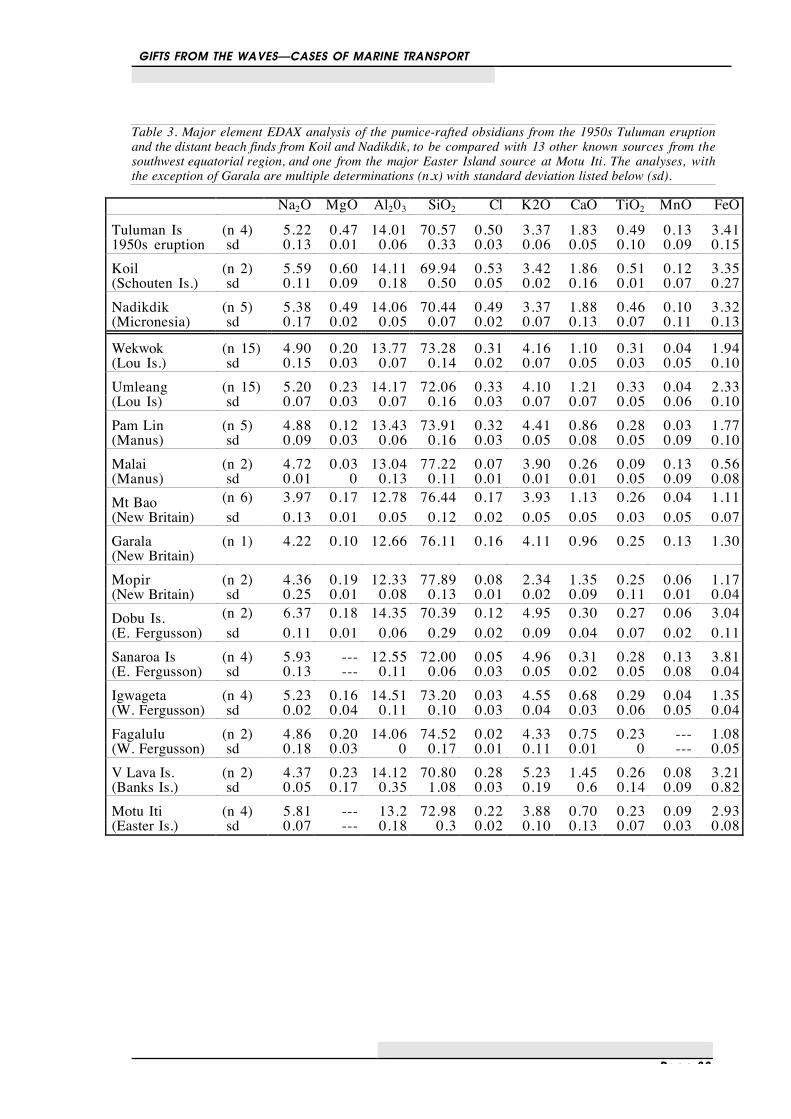
Table 3. Major element EDAX analysis of the pumice-rafted obsidians from the 1950s Tuluman eruptionand the distant beach finds from Koil and Nadikdik, to be compared with 13 other known sources from thesouthwest equatorial region, and one from the major Easter Island source at Motu Iti. The analyses, withthe exception of Garala are multiple determinations (n.x) with standard deviation listed below (sd).
Na2O MgO Al203 SiO2 Cl K2O CaO TiO2 MnO FeOTuluman Is (n 4) 5.22 0.47 14.01 70.57 0.50 3.37 1.83 0.49 0.13 3.411950s eruption sd 0.13 0.01 0.06 0.33 0.03 0.06 0.05 0.10 0.09 0.15Koil (n 2) 5.59 0.60 14.11 69.94 0.53 3.42 1.86 0.51 0.12 3.35(Schouten Is.) sd 0.11 0.09 0.18 0.50 0.05 0.02 0.16 0.01 0.07 0.27Nadikdik (n 5) 5.38 0.49 14.06 70.44 0.49 3.37 1.88 0.46 0.10 3.32(Micronesia) sd 0.17 0.02 0.05 0.07 0.02 0.07 0.13 0.07 0.11 0.13
Wekwok (n 15) 4.90 0.20 13.77 73.28 0.31 4.16 1.10 0.31 0.04 1.94(Lou Is.) sd 0.15 0.03 0.07 0.14 0.02 0.07 0.05 0.03 0.05 0.10Umleang (n 15) 5.20 0.23 14.17 72.06 0.33 4.10 1.21 0.33 0.04 2.33(Lou Is) sd 0.07 0.03 0.07 0.16 0.03 0.07 0.07 0.05 0.06 0.10Pam Lin (n 5) 4.88 0.12 13.43 73.91 0.32 4.41 0.86 0.28 0.03 1.77(Manus) sd 0.09 0.03 0.06 0.16 0.03 0.05 0.08 0.05 0.09 0.10Malai (n 2) 4.72 0.03 13.04 77.22 0.07 3.90 0.26 0.09 0.13 0.56(Manus) sd 0.01 0 0.13 0.11 0.01 0.01 0.01 0.05 0.09 0.08Mt Bao (n 6) 3.97 0.17 12.78 76.44 0.17 3.93 1.13 0.26 0.04 1.11(New Britain) sd 0.13 0.01 0.05 0.12 0.02 0.05 0.05 0.03 0.05 0.07Garala (n 1) 4.22 0.10 12.66 76.11 0.16 4.11 0.96 0.25 0.13 1.30(New Britain)Mopir (n 2) 4.36 0.19 12.33 77.89 0.08 2.34 1.35 0.25 0.06 1.17(New Britain) sd 0.25 0.01 0.08 0.13 0.01 0.02 0.09 0.11 0.01 0.04Dobu Is. (n 2) 6.37 0.18 14.35 70.39 0.12 4.95 0.30 0.27 0.06 3.04(E. Fergusson) sd 0.11 0.01 0.06 0.29 0.02 0.09 0.04 0.07 0.02 0.11Sanaroa Is (n 4) 5.93 --- 12.55 72.00 0.05 4.96 0.31 0.28 0.13 3.81(E. Fergusson) sd 0.13 --- 0.11 0.06 0.03 0.05 0.02 0.05 0.08 0.04Igwageta (n 4) 5.23 0.16 14.51 73.20 0.03 4.55 0.68 0.29 0.04 1.35(W. Fergusson) sd 0.02 0.04 0.11 0.10 0.03 0.04 0.03 0.06 0.05 0.04Fagalulu (n 2) 4.86 0.20 14.06 74.52 0.02 4.33 0.75 0.23 --- 1.08(W. Fergusson) sd 0.18 0.03 0 0.17 0.01 0.11 0.01 0 --- 0.05V Lava Is. (n 2) 4.37 0.23 14.12 70.80 0.28 5.23 1.45 0.26 0.08 3.21(Banks Is.) sd 0.05 0.17 0.35 1.08 0.03 0.19 0.6 0.14 0.09 0.82Motu Iti (n 4) 5.81 --- 13.2 72.98 0.22 3.88 0.70 0.23 0.09 2.93(Easter Is.) sd 0.07 --- 0.18 0.3 0.02 0.10 0.13 0.07 0.03 0.08

Page 34
Extraneous materials inthe Marshalls
The atolls making up the Marshall Islands are full atolls, with no volcanic cores exposed atany accessible location. Thus the entire range of naturally occurring raw materials available tothe Marshallese is derived of calcium carbonate, either in form of coral or in form of shells.The substrate of the islands is made up of calcium-carbonate cemented coral conglomerates(“beachrock”), and the soils are made of their erosion products, sand, mixed with rather lim-ited organic material derived from decomposed vegetative matter. Any material of volcanicorigin has to come in from the outside, be it via human transport, current transport or trappedin other objects. Let us now have a look at the types of extraneous materials brought into theMarshall Islands and the uses they found there. The materials discussed in the next sectionswill be soil, volcanic rock, pumice, driftwood, drifted canoe hulls and Japanese glass floats.Exploitation of drift material was a common procedure in the Pacific. The Tongans, forexample, relied on washed up Sperm whales for their supply of ivory (Martin 1817). Driftmaterial washed ashore in the Marshall islands was much sought after resource. At the timeof European contact shipwrecks and flotsam were the property of the chiefs. In Marshallesecustom, the reefs, especially those where fishing was good, belonged to the irooj, who couldclaim them unilaterally (Tobin 1952, p. 11). The property rights of each wato extended as farinto the lagoon as one could stand, commonly waist-deep. In the 20th century, it seems, theirooj of the abutting land had customary rights to all flotsam and jetsam and ligan washedashore (Tobin 1952, p. 12).
Soil
Imports of soil to the atolls of the Marshall Islands seems to have occurred mainly in theform of ship's ballast, brought by copra trading vessels returning partially empty from thevolcanic high islands in the Carolines (such as Ponape) (cf. Fosberg 1961). Import of soilfrom high islands on Jaluit Atoll, mainly to run the experimental garden located at theGerman capital. The import was conducted by both by the Germans and the Japanese(Fosberg & Sachet 1962, p. 1; Stevenson 1914, p. 150). The import of soil as ships ballast,however, did apparently not occur on a regular basis. The German colonial report for 1895mentions that “the high cost of earth when a ship chances to bring ballast into the harbourprevents the extension of the gardens” (Anonymous 1895). During the period of Japaneseadministration, import of soil directly from Japan has been reported (Price 1935, p. 256).Post-World War II import of soil occurred to Kwajalein (Sachet 1955, p. 19). “German”soil is also reported to have been imported to Japtan Island, Enewetak Atoll (Lamberson1987, p. 24), and Majuro (Erkelens 1990—own research could not hitherto substantiate this

GIFTS FROM THE WAVES—CASES OF MARINE TRANSPORT
Page 35
claim). The Japanese, intent on staying for a long time, imported night soil from Japan toimprove the soil on both Eneen-Kio (Wake) and Wotje Atolls (Kephardt 1950, p. 34).Import of the same material can be assumed for two, or three other major Japanese bases,namely Kwajalein/Roi-Namur, Taroa (Maloelap Atoll) and Jaluit. These soil imports arelikely to have been very small, just confined to gardening plots.
.
12
10
8
6
4
14
16
18
2
20
166 168 170164162160 172 174
NORT
H
MejitAilinginae
Kwajalein
Maloelap
Wotje
Erikup
Aur
Likiep
Ebon
Eneen-Kio
Bokak
Bikar
UtrikEnewetak Bikini Ronglap Rongrik
Taka
Jemo Ailuk
Wotho
Ujelang
UjaeLae
LibNamu
Ailinglaplap
NamdrikKili
Jaluit
Narikrik
Mile
Arno
JabatMajuro
0 300
nautical miles
Soil imports
Figure 20. Map of the Marshall Islands showing the distribution of recorded occurencees of soil imports.

GIFTS FROM THE WAVES—CASES OF MARINE TRANSPORT
Page 36
Volcanic stones
Although the atolls of the Marshall Islands are entirely made up of coralline material, theresome reports of volcanic stones found on the surface. The larger ones are usually interpretedas imports by people, while smaller ones may have arrived by accident, such as stones caughtor entangled in the root area of driftwood trees. A record of a basalt boulder found on Bokak(Cameron 1923, p. 397) seems to have been a faulty identification of blackened coral boul-ders (Sachet 1955, p. 16; Fosberg 1955a, p. 3; 28).Traditionally basalt blocks (columns?) are also known from Namu and Aur. The basalt blockon Namu, named “Lutwätonmour” (long-life giver), was originally located on the watoBokar. The stone is said to have been removed by the vessel Morning Star, as the stone hadconsiderable ritual importance and was said to be the origin of the early chiefs of the RalikChain (Erdland 1914, p. 345; Krämer & Nevermann 1938, p. 41). Another basalt block,named “Lidebreja” and said to be the “sister” of the one on Namu, was known on Aur(Erdland 1914, p. 345; Krämer & Nevermann 1938, p. 74). Given the contacts theMarshallese had with Kosrae and Pohnpei, an import from there is quite possible.During a geomorphological survey of Taroa, Maloelap, a few pebbles of volcanic origin(igneous rock) were found near a wall of the main generator building. The origin of these canbe explained in two ways: either they were part of some construction material imported by theJapanese, or they stem from the root complex of a driftwood tree which came from a volcanicor high island (Spennemann 1989b).Wells (1951, p. 3) reports that one driftwood tree seen by him on Arno in 1950 contained“sizeable chunks of quartzitic grey-green sandstone” in its root network. Extraneous rockwas encountered during the INRS survey of Mile Atoll only once. As a extraneous material aboulder of volcanic rock of unknown origin and purpose measuring some 0.3m in diameterwas seen on the western section Burrh Island (pers. obs.). Rosendahl had found flakes ofvolcanic rock during archaeological surveys on Ebon (two specimens) and Majuro (one spec-imen; Rosendahl 1987, p. 120; 122-123).
Traditional uses
Where possible, island populations living on coral limestone islands or coral atolls attemptedto obtain volcanic rock for tool manufacture. The acquisition of volcanic stones from otherislands has been documented inter alia for Ant Atoll (near Pohnpei; Sachet 1955), WoleaiAtoll (Chamisso 1821, p. 104), and Ifalik Atoll (Carolines; Sachet 1955). In some instances,where a systematic acquisition from volcanic islands could be maintained over a prolongedperiod of time, the use of volcanic rock has been very common (cf. Tonga: Spennemann1986a; 1991b).

GIFTS FROM THE WAVES—CASES OF MARINE TRANSPORT
Page 37
.
12
10
8
6
4
14
16
18
2
20
166 168 170164162160 172 174
NORT
H
MejitAilinginae
Kwajalein
Maloelap
Wotje
Erikup
Aur
Likiep
Ebon
Eneen-Kio
Bokak
Bikar
UtrikEnewetak Bikini Ronglap Rongrik
Taka
Jemo Ailuk
Wotho
Ujelang
UjaeLae
LibNamu
Ailinglaplap
NamdrikKili
Jaluit
Narikrik
Mile
Arno
JabatMajuro
0 300
nautical miles
Volcanics
Figure 21. Map of the Marshall Islands showing the distribution of recorded occurencees of volcanicrocks.
Stones caught or entangled in the root area of driftwood trees have traditionally been used asa source of raw material in the Marshall Islands and on other atolls of Micronesia. dekã nonwere the heavy volcanic stones necessary for the um, the earth oven, while tilaan is the termfor ordinary pumice Chamisso (1986, p. 139) describes that large stones used for grindingshell adzes are commonly obtained from driftwood trees and mentions that any such stonesfound had to be given to the irooj at punishment of death (Chamisso 1910, p. 168). Finsch(1893, p. 66; 154) as well as Krämer & Nevermann (1938, p. 145) question whether largestones could in fact stem from such sources. Apart from stones, also pieces of iron werefound by the Marshallese in driftwood parts of wrecked European vessels (Chamisso 1910,p. 168). Chamisso verified the Marshallese statement in this regard as he himself found

GIFTS FROM THE WAVES—CASES OF MARINE TRANSPORT
Page 38
planking with nails on Wotje. There is no recorded use of obsidian in the Marshall Islands atany time, but the use of glass flakes, when they became available has been documented byChamisso (1821, p. 156; cited after 1910, p. 186), Kotzebue (1821) and Krämer &Nevermann (1938, p. 145). Their main use was for carving and scraping of wooden items.
Pumice
In the literature, pumice is reported for a number of atolls in the Marshall Islands (see table4). The first observation of pumice in the Marshall Islands was made by Chamisso (1821, p.156; cited after 1910, p. 186), possibly on Ailuk Atoll. The occurrence of pumice appears tobe temporal, dependent on volcanic eruptions in nearby areas. Grundemann (1887, p. 442)mentions large pumice beds for Ailuk. It is possible that this occasion was caused by theexplosion of the Cracatoa in 1883 and that the pumice was moved there by the currents. Thisis asserted by Elschner (1915, quoted in Sachet 1955, p.5). Steinbach (1894) mentions thatan especially large number of pumice were washed ashore in Jaluit and other parts of theMarshall Islands in September 1894. At the time, ships are said to have driven/sailed throughlarge fields of drifting pumice stone.There appears to be a clear distinction between the pumice seen on the surface and thepumice seen buried. All buried pumice seen by the author was of a brownish colour, while allpumice found on the surface was of a dark greyish to greyish-black colour. It is possible thatthis colour distinction is caused by the increased oxidisation of the iron contents in thepumice when subjected to a continuous regime of moisture. A buried pumice bed was seenon Majuro Island (Laura) Majuro Atoll in 1991. The bed is covered by about 0.2m-0.3m ofsand.This distribution of pumice records in the RMI shows no spatial distribution in favour of onegeographical area. The sizes of the pumice varied from the small scattered pebbles, tofootball-sized pieces (Sachet 1955).On Arno Atoll (Stone 1951, p. 10; Wells 1951, p. 3), where it occurred both high up on thebeaches of the lagoonal and ocean side, as well as inland. Wells (1951, p. 3) reports sizes“from small pebbles to the size of one's head.” During the INRS survey of Arno Atoll,pumice was seen on Kilomman and on Arno Islands. The pumice on Kilomman was foundon the northern tip of the island, lying on the surface of the beaches (in the strand vegetationzone) and in the centre. The pumice occurred in medium to large sizes, measuring up to 15cmin diameter, was of small to medium sized porosity (mainly 1-2 mm, some up to 5mm), andof greyish colour with black inclusions. The pumice seen on Arno Island was found in aburied deposit in the centre of the island, exposed in trenches dug on the (then) TaiwaneseExperimental Agricultural Farm. This pumice was of fine porosity (1-2 mm) and of a yellowcolour.

GIFTS FROM THE WAVES—CASES OF MARINE TRANSPORT
Page 39
Table 4. Records for unworked pumice in the Marshall Islands
Atoll Island Year Colour Location ReferenceAiluk 1816 Chamisso 1910:186Ailuk 1886 Grundemann 1887:442Ailuk 1950s Fosberg 1955; Sachet 1955:2Arno 1950s Stone 1951:10; Wells 1950:3Arno Arno 1991 black surface Spennemann unpubl.Arno Arno 1991 orange buried Spennemann unpubl.Arno Kilomman 1991 black surface Spennemann unpubl.Bikini Bikini 1946/7 ? surface Emery et al. 1954:37Bokak 1950s Fosberg 1955; Sachet 1955:2Ebon Ebon 1992 d.gray surface Spennemann pers. obs.Eneen-Kio Peale surfaceEnewetak 1980s surface Coln 1987:31Jaluit 1894 surface Steinbach 1894Jemo 1950s Fosberg 1955; Sachet 1955:2Kwajalein 1950s Fosberg 1955; Sachet 1955:2Kwajalein Ebadon 1993 black surface Spennemann 1993Kwajalein Mejatto 1993 black surface Spennemann 1993Majuro Ajeltake 1989 black surface Spennemann unpubl.Majuro Enumanet 1990/2 black surface Spennemann unpubl.Majuro Laura 1989 brown buried Spennemann unpubl.Majuro Rongrong 1989 black surface Spennemann 1989cMaloelap Taroa 1989 black surface Spennemann 1989bMaloelap Eoon-epje 1989 black surface Spennemann 1989bMile Bokwa-en-keaar 1991 black surface Spennemann unpubl.Mile Garu 1991 black surface Spennemann unpubl.Mile Lukunor 1991 black surface Spennemann unpubl.Mile Mile 1991 black surface Spennemann unpubl.Mile Nalu 1991 black surface Spennemann unpubl.Mile Obo-en 1991 black surface Spennemann unpubl.Mile Tokowa 1991 black surface Spennemann unpubl.Nadikdik Aleon-eo 1991 black surface this paperNadikdik Aleon-kan 1991 black surface this paperUjae 1950s Fosberg 1955; Sachet 1955:2; Fosberg
& Carroll 1965:Plate 23cUjelang 1950s Fosberg 1955; Sachet 1955:2Utirik 1950s Fosberg 1955; Sachet 1955:2Wotho 1950s Fosberg 1955; Sachet 1955:2Wotje Wotje 1992 black surface Spennemann unpubl.Wotje Wotje 1992 black surface Spennemann unpubl.
Pumice was found during the INRS of Mile Atoll on a number of islands. Most of thepumice seen was of grey to grey-black colouration and of a size smaller than a man's fist.Pumice was seen on the following islands of Mile Atoll: Bokwa-en-keaar, Obo-en, Garu,Mile, Nalu, Lukunor and Tokowa. In addition, it was encountered on Aelon-eo and Aelon-Kan on Nadikdik Atoll (perds. obs.). In addition, pumice was seen on Mile in 1992.Chemical analyses are given for Bokak, Jemo, Ujae, Wotho, and Ujelang (Sachet 1955, p.21). All samples were ignited at 900°C for 15 minutes. The analysis (table 5) showed that

GIFTS FROM THE WAVES—CASES OF MARINE TRANSPORT
Page 40
Table 5. Spectrographic analyses of pumice found in the Marshalls 1951-52 (Sachet 1955)
Location Jemo Jemo Jemo Ujae Ujelang Ujelang Wotho BokakColour white dark black pale grey grey grey grey greyTexture medium fine coarse medium medium medium medium mediumCu 0.009 0.003 0.009 0.003 0.002 0.003 0.001 0.001Mn 0.1 0.2 0.1 0.1 0.09 0.1 0.1 0.1Co 0.0009 0.002 0.002 0 0.001 0.001 0 0Fe 3.3 7.7 5.3 2.7 3.6 3.5 2.9 3.4B 0 0 0.004 0 0 0 0.002 0.002Mo 0 0 0 0 0 0 0 0Zn 0 0 0 0 0 0 0 0P 0 0 0 0 0 0 0 0% Loss* 2.2 1.0 0.14 4.3 3.4 4.6 4.1 4.1
* Loss on ignition.
The movement of drift material from the southern to the northern hemisphere is notuncommon. Following the explosion of the Cracatoa in 1883 large amounts of pumice wereproduced which were washed ashore on Nauru, but also the Marshall Islands and even on theatolls of the northwestern Hawaiian Islands (Elschner 1915, quoted after Sachet 1955).In Zealand there is ample evidence of past events entailing large amounts of sea-raftedpumice, such as Loisel's pumice and Taupo pumice, which form huge deposits (eg. Pullar etal. 1977; McFadgen 1985).
Traditional uses
Traditionally, pumice had two principal uses in the Marshall Islands: i) it was used as afertiliser in taro patches, either unmodified or in pounded form. This has been described forAiluk Atoll by Grundemann (1887, p. 442); and ii) more commonly it served as abraders andgrinding material for the manufacture of shell beads (Krämer & Nevermann 1938, p. 145;147).Pumice abraders have been found in archaeological sites in Arno, Majuro, Aur, Ebon, Lae,Likiep, Maloelap and Mile by Rosendahl (1987, p. 120; 122-123).1
Throughout the Pacific pumice has been a resource which was exploited for a variety ofpurposes: Fertilisation with pumice has been reported for Kiribati (Sachet 1955, p. 12);and in the Indian Ocean for the Cocos-Keeling Islands (Guppy 1889, cited after Goetz 1914,p. 29). The capacity of pumice to float was used to manufacture net floats in New Zealand(Bellwood 1978, p. 45; Davidson 1984, p. 71; Leach 1979, p. 96; 99; Leahy 1976, p. 58;Skinner 1923, p. 101)
1 Rosendahl’s argument to include all rounded pieces in his classification as artefacts is not warranted. Pumice
can be abraded by normal environmental action, such as rain and wind, as well as by wave action if pumice i sdeposited in a zone frequently reworked by cyclical (spring) high tides.

GIFTS FROM THE WAVES—CASES OF MARINE TRANSPORT
Page 41
.
12
10
8
6
4
14
16
18
2
20
166 168 170164162160 172 174
NORT
H
MejitAilinginae
Kwajalein
Maloelap
Wotje
Erikup
Aur
Likiep
Ebon
Eneen-Kio
Bokak
Bikar
UtrikEnewetak Bikini Ronglap Rongrik
Taka
Jemo Ailuk
Wotho
Ujelang
UjaeLae
LibNamu
Ailinglaplap
NamdrikKili
Jaluit
Narikrik
Mile
Arno
JabatMajuro
0 300
nautical miles
Pumice
Figure 22. Map of the Marshall Islands area showing the distribution of recorded occurrences of pumice
The majority of recorded applications uses the fine grained coarseness of the pumice forabrasive purposes, mainly for wood working. This has been described for Kiribati (Koch1965, p. 151). On Hawaii (Kirch 1985), where Te Rangi Hiroa (1964) describes the use ofpumice as rubbers (abraders) to finish the outer surface of the canoe hull. For Hawaiiancanoe builders the pumice abrader formed a medium coarse grade of abrader (nº 3) in seriesof six, ranging from coarse (fine coral, nº 1) to polishing stones (close grained basalt, nº 6).New Zealand, where there is an abundance of pumice available, shows a great variety ofotherwise more unique applications. There, pumice has been used for beads in necklaces(Davidson 1978, p. 221; 1979, p. 197-198; 1986, p. 79; Edson & Brown 1977; Leahy 1974,p. 40-42); as pigment containers (Davidson 1984, p. 109); as bowls (Davidson 1984, p. 109);and as gourd stoppers (Davidson 1984, p. 109). In addition, pumice blocks were apparently

GIFTS FROM THE WAVES—CASES OF MARINE TRANSPORT
Page 42
worked at some localities, presumably for export (Davidson 1984, p. 109) and shaped inform of objects (models?) commonly made of other materials, such as adzes and patu(Davidson 1984, p. 108-109).
Driftwood
The first European account for the occurrence of driftwood in the Marshall Islands is givenby Chamisso who noted it on Wotje in 1816 (Chamisso 1910). Driftwood is a commonoccurrence on the atolls in the Marshall Islands (Hager 1886, p. 57). Driftwood has beenreported from the shoreline of many atolls, such as Majuro (Spennemann 1990a; 1992),Arno (Wells 1951, p. 3); Mile (pers. obs. ); Ebon (pers. obs.), Maloelap (pers obs.), Jaluit(Schneider 1891) and has also been found in the centre of others, such as Wake Atoll(Grooch 1936, p. 92; 1938) or Bokak Atoll (Irmer 1895), both in the northern Marshalls.Wells (1951, p. 3) who reports that driftwood trees arriving from North America (California)and carried by the Northern Equatorial Current are not uncommon. For Arno Atoll Wellsmentions a cut fir log measuring 5 by 55 feet and a trunk of a redwood tree., and cut logswere also seen by the author on Majuro Atoll. Fosberg (1956, plate 13A) shows the rootsection of a driftwood tree on Kwajalein Atoll.Long distance transport of material bring up some surprises. A driftwood tree washed ashoreat Butaritari (Kiribati) in 1906 during a gale blowing from the west carried a crocodile(Krämer 1906, p. 319; 1927, p. 50), which must have come from the Solomon Islands, Palauor even further afield in the west. Given the position of Butaritari it is most likely that the treewas pushed by the southern equatorial counter current. Koch (1965, p. 170) mentions thatdriftwood from the Solomon Islands was a desired type of wood in Kiribati, which waswashed ashore on the eastern side of the islands.Let us now look at the occurrence of driftwood on Nadikdik and neighbouring Mile Atoll.The trees seen by the author can be summarised into three categories: cut driftwood logs,stemming from saw-milling operations along the coast of the Pacific Northwest, breadfruittrees some of which may originate from other locales in the Marshall Islands, and othertropical and northern trees which may come from the Pacific North West, Japan or SE Asia.Cut drift logs were a common occurrence during the INRS survey both on Mile Atoll andNadikdik Atoll. They commonly measured between 1.0 and 1.5m in diameter and anythingfrom 1.0 to about 15m in length. Cut drift logs were seen on the lagoonal sides of thefollowing islands: Arbar, Bogukarik, Dobo-en, Enanlik, Lukunor (3 logs), Tokowa, and onthe ocean side of Burrh all on Mile Atoll, and the islands of Aelon-eo, Nadikdik and Aelon-Kan on Nadikdik Atoll. Other driftwood, apparently mainly trunks from large breadfruittrees (Artocarpus sp.) were seen on the ocean sides of Dobo-en and Bokwa-en-keaar. Onseveral islands on Mile (Garu, Namake and Enanlik) and Nadikdik Atolls (Aelon-eo)bamboo was found, some of which most likely stems from Japanese pole and line fishingvessels (pers. obs). Some of the driftwood trees seen had very large buttresses suggestinggreat age of the trees and documenting that not only saw logs have drifted ashore in theMarshalls (figure 21).

GIFTS FROM THE WAVES—CASES OF MARINE TRANSPORT
Page 43
.
12
10
8
6
4
14
16
18
2
20
166 168 170164162160 172 174
NORT
H
MejitAilinginae
Kwajalein
Maloelap
Wotje
Erikup
Aur
Likiep
Ebon
Eneen-Kio
Bokak
Bikar
UtrikEnewetak Bikini Ronglap Rongrik
Taka
Jemo Ailuk
Wotho
Ujelang
UjaeLae
LibNamu
Ailinglaplap
NamdrikKili
Jaluit
Narikrik
Mile
Arno
JabatMajuro
0 300
nautical miles
DriftwoodCut saw logs
Figure 22. Map of the Marshall Islands area showing the distribution of recorded occurrences of pumice
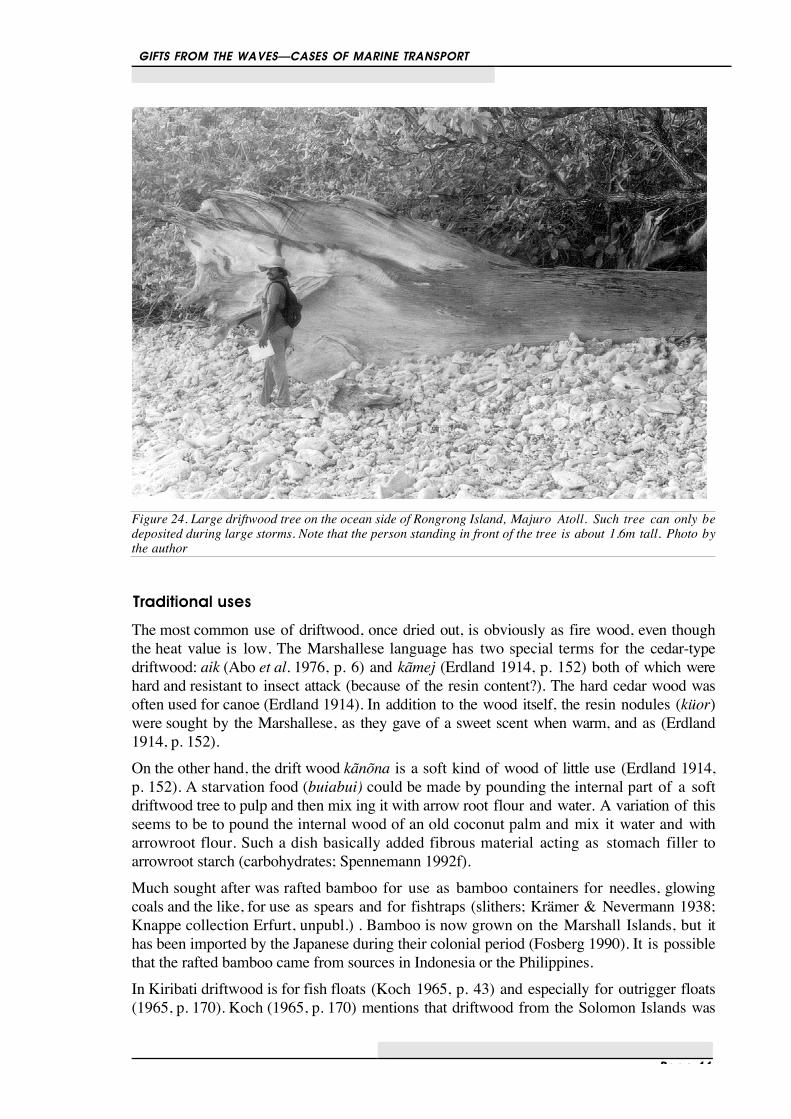
GIFTS FROM THE WAVES—CASES OF MARINE TRANSPORT
Page 44
Figure 24. Large driftwood tree on the ocean side of Rongrong Island, Majuro Atoll. Such tree can only bedeposited during large storms. Note that the person standing in front of the tree is about 1.6m tall. Photo bythe author
Traditional uses
The most common use of driftwood, once dried out, is obviously as fire wood, even thoughthe heat value is low. The Marshallese language has two special terms for the cedar-typedriftwood: aik (Abo et al. 1976, p. 6) and kãmej (Erdland 1914, p. 152) both of which werehard and resistant to insect attack (because of the resin content?). The hard cedar wood wasoften used for canoe (Erdland 1914). In addition to the wood itself, the resin nodules (küor)were sought by the Marshallese, as they gave of a sweet scent when warm, and as (Erdland1914, p. 152).On the other hand, the drift wood kãnõna is a soft kind of wood of little use (Erdland 1914,p. 152). A starvation food (buiabui) could be made by pounding the internal part of a softdriftwood tree to pulp and then mix ing it with arrow root flour and water. A variation of thisseems to be to pound the internal wood of an old coconut palm and mix it water and witharrowroot flour. Such a dish basically added fibrous material acting as stomach filler toarrowroot starch (carbohydrates; Spennemann 1992f).Much sought after was rafted bamboo for use as bamboo containers for needles, glowingcoals and the like, for use as spears and for fishtraps (slithers; Krämer & Nevermann 1938;Knappe collection Erfurt, unpubl.) . Bamboo is now grown on the Marshall Islands, but ithas been imported by the Japanese during their colonial period (Fosberg 1990). It is possiblethat the rafted bamboo came from sources in Indonesia or the Philippines.In Kiribati driftwood is for fish floats (Koch 1965, p. 43) and especially for outrigger floats(1965, p. 170). Koch (1965, p. 170) mentions that driftwood from the Solomon Islands was

GIFTS FROM THE WAVES—CASES OF MARINE TRANSPORT
Page 45
a desired type of wood to be used in Kiribati canoe manufacture (kuia, the best wood on theislands), which was washed ashore on the eastern side of the islands.
Canoe hulls and drift voyages
Canoes and canoe hulls are other indicators of drift materials in the Marshall Islands. Theauthor has seen two canoe hulls which appear to be from Solomon Islands canoes. One wasseen on Mile (figure 25), the other, a Binabina-style canoe on Wotje Atoll (figures 26-27 ).1Reverse drift voyages from the Marshalls to the Solomons and PNG are also on record. 2
Figure 25. A Solomon islands canoe hull washed ashore on Mile Atoll, and reused, with a make-shiftoutrigger, as a lagoonal fishing craft (photographed in 1991).
1 It would appear that the canoe hull belongs to a Binabina-style canoe from the central Solomon Islands
(Ysabel[Isabel, Bogutu], Guadalcanal, and Gela [Nggela; Florida]). Such canoes have been described by Haddon& Hornell(1937:101) and Pule (1983). The descriptions by Pule (1983) and Hornell (1936), however, show acanoe made entirely of planks from the keelpiece up. The characteristics of the Binabina canoes is that the keelpart is made from a dug out log, that the bow has a tapering section ending in a straight edge, that the bottompiece of the hull has cleats for braces at both bow and stern. The cleats for the seats are set into the upperplanks (see Pule 1983:17). The sown-on planks of the canoe as well as the sown-on bow section are missing inthe Wotje example.
2 District officer Kavieng reports arrival of a one-masted cutter in distress from Jaluit, Cutter property ofNaiborgak Co, Jaluit, en route to Ebon in 1920, blown to sea, reached Gardner I. off Kavieng after 36 days ofdrift (Australian Archives, Record Nº AA A457/1 Item 201/48)

GIFTS FROM THE WAVES—CASES OF MARINE TRANSPORT
Page 46
Figure 26. A Solomon Islands canoe hull washed ashore on the ocean side of Wotje Island, Wotje Atoll,photographed in 1992.
It is significant that material from the Solomon Islands not only drifts to Kiribati (Koch1965, p. 170) but also through the doldrums to the southern Marshalls.I-Kiribati canoes (with or without crew) were often found adrift. A sail boat hull of amodern Kiribati design drifted ashore in Mile in the late 1980s and has been refurbishedsince (own obs.) I-Kiribati were often stranded on the southern Marshalls, especially Arnoand Mile, and these atolls have several genealogical links with the northern and central atollsof Kiribati. Shipwrecked i-Kiribati were picked up by the brig Mercury south of Ebon in1858 (Hezel 1979, p. 121). In 1882 other i-Kiribati were found drifting south of Ebon by theAmerican vessel Northern Light (Hezel 1979, p. 139). During the 19th century dispersed i-Kiribati were also living on Namorik (1851; Hezel 1979, p. 121; 1868; ibid. 127) and Jaluit(1871; ibid. 129; 1879 ibid. 136).

GIFTS FROM THE WAVES—CASES OF MARINE TRANSPORT
Page 47
Figure 27. A Solomon islands canoe hull washed ashore on the ocean side of Wotje Island, Wotje Atoll,photographed in 1992. Top: stern; bottom: bow.

GIFTS FROM THE WAVES—CASES OF MARINE TRANSPORT
Page 48
Two Catholic missionaries together with fourteen Gilbertese left Apaiang Atoll en route toMarakei in early September 1942. The canoe eventually wrecked on Mile Atoll in theMarshalls (Richard 1957a, p. 401). Even today, i-Kiribati fishermen occasionally drift to theshores of the southern Marshall Islands.
.
12
10
8
6
4
14
16
18
2
20
166 168 170164162160 172 174
NORT
H
MejitAilinginae
Kwajalein
Maloelap
Wotje
Erikup
Aur
Likiep
Ebon
Eneen-Kio
Bokak
Bikar
UtrikEnewetak Bikini Ronglap Rongrik
Taka
Jemo Ailuk
Wotho
Ujelang
UjaeLae
LibNamu
Ailinglaplap
NamdrikKili
Jaluit
Narikrik
Mile
Arno
JabatMajuro
0 300
nautical miles
CanoesBoats &c.
Figure 28. Map of the Marshall Isands showing the distrbution of recorded canoe strandings.
A very different example comes from Japanese PoW interrogation files captured by the USforces during WWII: On 27 May 1943 a Consolidated B-24 Liberator bomber crashed intothe sea 225m NW of Palmyra Atoll (crash site approx 8°32'N 164°20'W). The three

GIFTS FROM THE WAVES—CASES OF MARINE TRANSPORT
Page 49
survivors of the crew US crew drifted for 47 days in an inflatable life raft and arrived onJapanese-held Maloelap Atoll, having floated across the reef into the lagoon.1
A small fishing vessel went missing in 1979 off Hana, Maui, Hawaiian Islands and wasfound washed up on Bokak Atoll in 1989 (Thomas 1989, p. 33)Drift voyages from the west are also documented: Lamotrekese are reported on Arno(Chamisso 1986, p. 264; Kotzebue 1812, p. II 89), Pingelapese arrived on Jaluit (Krämer &Nevermann 1938, p. 35) and on different occasions, Yapese drifted to Aur Atoll (18thcentury, Chamisso 1986, p. 264) and Kili Island (Hezel 1979, p. 127; entry for 1868, BarkSyringia.). In addition canoes from Woleai arrived in the Marshalls (Chamisso 1986;Erdland, p. 315).
Modern drift material
The lagoonal and ocean shorelines of the islands in the southeastern parts of Mile Atoll werelittered with other drift material: Fishing-net floats of all kinds and sizes, as well as glass andplastic bottles, and fluorescent light tubes were quite abundant. Although they werecommonly concentrated in a zone reaching about 5-10m from the high tide mark of bothlagoonal and ocean shore, they could be encountered up to 30m inland. This readily testifiesto the degree of water washing the islands interior's can experience during storms or excep-tional high tides caused as a reaction to high pressure systems in the vicinity of the atoll. Thepiece of pumice found on Nadikdik was in a find location among a number of large glassfloats and modern plastic floats.Another good example of extraneous objects are the Japanese glass fishing floats, many ofwhich have been washed ashore in the atolls of the Marshall Islands. While of recent origin,they too are indicative of the ocean currents and that directions from which materials arewashed to the atolls. A great amount of Japanese glass floats has been found on the westcoast of the USA, washed ashore by the currents (Wood 1985).
Modern uses
While of recent origin, glass floats were (and still are used) as convenient water containers.The use of glass floats with a hole punched in as water storage containers is described forBikini Atoll. This use is an adaptation of the traditional water containers, which consisted ofcoconut shells with one or more of the eyes drilled out (Krämer & Nevermann 1938). Todaymodern plastic floats are used for the same purpose (Ebon, Spennemann pers obs.; Mile,Spennemann pers obs.).
1 "Prisoner of War Interrogation Report, 6th Base Force Secret Number 330, Headquarters 6th Base Force July
1943" and 'Prisoner of War Interrogation Report Annex 23 July 1943" translation of captured Japanesedocument JICPOA Item 5703 captured at Kwajalein Atoll, Receievd JCPOA 11 February 1944 contained in file"Joint Intelligence Centre Pacific Ocean Areas. Translations of Japanese documents captured Makin–KwajaleinAtoll–Namur Island–Munda and Tarawa. Also primary interrogation of Japanese prisoners of war, March 1944.Record series AWM54 file 423/4/40 Part 1. Archives of the Australian War Memorial, Canberra, Australia.
Page 50
Implications
The places of confirmed origin of sea rafted materials have been plotted in figure 2. Itbecomes evident that material from all areas of the Pacific (with the exception—so far—ofSouth America and Australia proper) has arrived in the Marshall Islands and that thesouthern atolls are more favoured in this respect than then northern locales. Yet the currentpatterns are too general and do not allow micro variations, a scale that is required to makeuseful prediction. The distribution of the origin of sourced materials on the various MarshallIslands atolls has been plotted in figure 3. The mere perusal of the current charts would nothave made likely for example the dispersal of material from the Solomons or the BismarckArchipelago.Table 6 Known points of origin for drift materials encountered on atolls of the Marshall Islands
Locality Target Item floatedApaiang, Kiribati Mile canoe load of peopleCalifornia, North America Arno, Majuro, Mile,
Nadikdik, Wakecut fir logs
Central Solomons Mile, Wotje canoe hullJapanKiribati (general) Ebon, Namorik canoe load of peopleKiribati (general) Mile sailboat hullKrakatau, Indonesia Ailuk etc. pumiceLamotrek Atoll, FSM Arno canoe load of peopleMaui, Hawaii Bokak skiffPalmyra Atoll (225 nmNWof…)
Maloelap rubber dinghy from crashed B-24
Phillipines (?) bambooPingelap Atoll, FSM Jaluit canoe load of peopleTuluman I., Bismarcks Nadikdik piece of pumice/obsidianWoleai Atoll, FSM Kili canoe load of peopleYap, FSM Kili, Aur canoe load of people
In addition, there is evidence for internal drift in the Marshall Islands archipelago.Following the 1905 typhoon the southern atolls of Nadikdik, Mile, Arno and Jaluit, theremains of canoes, wooden bowls, houses and corpses were washed ashore on EnewetakAtoll (Jeschke 1906). Following a devastating typhoon in 1840 survivors from Mejit Islandwere washed ashore on Likiep Atoll (Erdland 1914, p. 18). Both cases of east to west drift,however, are well within the range of expectations given the overall current pattern.

GIFTS FROM THE WAVES—CASES OF MARINE TRANSPORT
Page 51
Figure 29. Map of the Pacific Ocean showing the confirmed origins of items washed ashore in the MarshallIslands.
As this small compilation has shown, there is still a need to systematically compile and drawon the historic literature and make use other contemporary material and sources. Coupledwith a reassessment of the Holocene sea-level curve this observation may have a bearing onthe interpretation of the distribution of mangrove species in Eastern Micronesia.

GIFTS FROM THE WAVES—CASES OF MARINE TRANSPORT
Page 52
.
12
10
8
6
4
14
16
18
2
20
166 168 170164162160 172 174
NORT
H
0 300
nautical miles
E
E
W,ES,ES,W,E
E
W
WS
S
S
WW
E
e
e
Figure 3. Map of the Marshall Islands showing the origin of drift materials encountred. Small letterdesignated drift within the Marshalls.
The implications of these instances of sea-borne obsidian on the interpretation of Pacificprehistory are manyfold. In the early days of Pacific Archaeology the analysis of driftvoyages and drifting objects in general had attained some currency, as the notion had beenadvanced that the settlement of the islands had occurred accidentally (Sharp 1956; 1957).Following the ensuing discussion, this mode of settlement had been discredited (Levison etal. 1973; Golson 1962). In subsequent times little analysis had been done until G. Irwin tookup the issue of environmentally aided settlement again (Irwin 1992).Flakes of obsidian localised to sources largely in the Bismarck Archipelago off New Guineahave frequently been used as evidence of long-distance transport of items and ideas.Bellwood and Koon (1989) showed the presence of Talasea obsidian as far north as Borneo,

GIFTS FROM THE WAVES—CASES OF MARINE TRANSPORT
Page 53
and much has been made of this connection, arguing for continued cultural contact betweenthe core Lapita area and the areas far north, the possible homeland of the Lapita people ortheir ancestral derivatives. Whilst the pottery of the site shows some similarity, this similarityis only general. The correlation, in fact, hinges on the dates, as well as the presence of Talaseaobsidian. The amount of obsidian represented in this single float is more than the totalamount of obsidian recovered from most other Lapita sites.The issue posed by the Marshall Islands specimen is that while the presence of Talaseaobsidian makes human transport from the Talasea source very likely, in fact extremely likely,it can no longer be taken for granted. While the presence of obsidian in far-flung locations islikely to imply human transport, this need not necessarily be so.

GIFTS FROM THE WAVES—CASES OF MARINE TRANSPORT
Page 54
Bibliography
Abo, T,, B.W.Bender, A. Capelle and T DeBrum(1976) Marshallese-English Dictionary. PALILanguage Texts: Micronesia. Honolulu:University of Hawaii Press.
Allen, J. (1984) In search of the Lapita homeland:reconstructing the prehistory of the BismarckArchipelago. Journal of Pacific History 19, 186-201.
Allen, M.S. & G.Bell (1988) Lapita flaked stoneassemblages sourcing, technological andfunctional studies. In P.V.Kirch & T.L. Hunt(eds), Archaeology of the Lapita CulturalComplex A critical review. Thomas BurkeMemorial Washington State Museum ResearchReport 5. Seattle Burke Museum. Pp. 83-98.
Ambrose, W.R. & R.C. Green (1972) First Mil-lenium BC transport of Obsidian from NewBritain to the Southern Islands. Nature 237, 37.
Ambrose, W.R. (1976) Obsidian and its prehistoricdistribution in Melanesia. In N. Barnard (ed.)The proceedings of a symposion on scientificmethods of research in the Study of AncientChinese bronzes and Southeast Asian metal andother archaeological artefacts. Melbourne:National Gallery. Pp. 351-378
Ambrose, W.R. (1978) The Loneliness of the LongDistance Trader in Melanesia. Mankind 11:326-333.
Ambrose, W.R., J.R. Bird & P. Duerden (1981) Theimpermanence of obsidian sources in Melanesia.In F. Leach and J.M. Davidson (eds)Archaeological studies of Pacific stone resources.British Archaeological Reports, InternationalSeries S-104. Oxford: British ArchaeologicalReports, International Series. Pp. 1-20.
AMS (1946a) U.S. Army Map Service TopographicMap of Knox Atoll, Northern Part. Based onU.S. Navy airphotography flown in 1944. Sheet8639 IV NE Chirubon NE. Map AMS SeriesW861 Scale 1:25,000. Washington, DC.: U.S.Department of the Army.
AMS (1946b) U.S. Army Map Service TopographicMap of Knox Atoll, Southern Part. Based on
U.S. Navy airphotography flown in 1944. Sheet8639 IV SE Chirubon SE. Map AMS SeriesW861 Scale 1:25,000. Washington, DC.: U.S.Department of the Army.
AMS (1947a) U.S. Army Map Service TopographicMap of Knox Atoll, Northern Part. Based onU.S. Navy airphotography flown in 1944. Sheet8639 IV NE Chirubon NE. Map AMS SeriesW861 Scale 1:25,000. Washington, DC.: U.S.Department of the Army.
AMS (1947b) U.S. Army Map Service TopographicMap of Knox Atoll, Southern Part. Based onU.S. Navy airphotography flown in 1944. Sheet8639 IV SE Chirubon SE. Map AMS SeriesW861 Scale 1:25,000. Washington, DC.: U.S.Department of the Army.
Anonymous (1904) Strandgut auf den MarshallInseln. Deutsche Kolonialzeitung 21, 78.
Anonymous (1905) Bericht des geschäftsführen denVizegouverneurs in Ponape über den Orkan vom20. April 1905. Deutsches Kolonialblatt16,407-409; 459.
Anonymous (1905) Bericht des geschäftsführen denVizegouverneurs in Ponape über den Orkan vomJuni 1905. 1. November 1905. DeutschesKolonialblatt 21 (1905, 645.
Barnes, C.A., D.F.Bumpus, J.Lyman (1948) OceanCirculation in Marshall Islands Area.Transactions of the American GeophysicalUnion. 29(6), 871-876
Bellwood, P. S. (1978a) Mans conquest of thePacific. The prehistory of Southeast Asia andOceania. Collins: Auckland, Sydney, London
Bellwood, P. S. (1978b) The Polynesians - prehistory of an island people. London: Thames andHudson
Bellwood, P. S. (1978c) Archaeological Research atlake Mangakaware, Waikato (1968–1970. OtagoUniversity Studies in Prehistroic Archaeology12 and NZAA Monograph 9. Dunedin: OtagoUniversity.

GIFTS FROM THE WAVES—CASES OF MARINE TRANSPORT
Page 55
Bellwood, P.S. & P. Koon (1989) “Lapita colonistsleave boast unburned:’ The question of Lapitalinks with Southeast Asia. Antiquity 63(240),613-622.
Bird, J.R., P. Duerden, W.R. Ambrose & F.B.Leach (1981) Pacific Obsidian catalogue. In F.Leach and J.M. Davidson (eds.) ArchaeologicalStudies of Pacific stone re sources. BritishArchaeological Reports, International Series S-104. Oxford: British Archaeological Reports,International Series. pp. 31-44
Blumenstock,.D.I. (ed.) (1961) A report on Typhoon ef fects upon Jaluit Atoll. Atoll ResarchBulletin 75. Washington, D.C.: Pacific Sci enceBoard.
Born, L. (1907) Ein Taifun auf den West-Karolinen(Die Verwüstung der Oleai Gruppe). DeutschesKolonialblatt 18, 567-572.
British Admiralty (1889) The search for dangers inthe South Pacific between New Zealand and theTonga Islands, 1888. London: HydrographicDepartment.
British Admiralty (1896) Admiralty survey duringthe year 1895. Geographical Journal 8, 54-57.
Bryan, Edwin H. (1971) Guide to Place names inthe Trust Territory of the Pacific Islands (theMarshall, Caroline and Marina Islands).Honolulu: Bishop Museum, Pacific ScienceInformation Center.
Cameron, J. (1923) John Cameron’s Odyssey. NewYork.
Catala, R.L.A. (1957) Report on the Gilbert Islands:some aspects of Human Ecology. Atoll ResarchBulletin 59. Washington, D.C.: Pacific ScienceBoard.
Chamisso, Adalbert von (1910) Reise um die Weltmit der Romanzoffschen Endeckungs-expeditionin den jahren 1815-1818 auf der Brig Rurik,Capitaen Otto v. Kotzebue Zweiter Theil:Bemerkungen und Ansichten. Chamisso's WerkeVierter Theil. Berlin: G.Hempel.
Chamisso, Adalbert von (1986) A yoyage aroundthe world with the Romanzov exploring expedition in the years 1815-1818 in the Brig Rurick,Captain Otto von Kotzebue. (translated byH.Kratz). Honolulu: University of Hawaii Press.
Colin, P.L. (1987) Physiography of EnewetakAtoll. In: Devaney, D.N., E.S.Reese, B.L.Burch& P.Helfrich, The Natural History of EnewetakAtoll. Volume I. The Ecosystem: Environments,Biotas, and Processes. Oak Ridge, Ten.:U.S.Department of Energy, Office of Scientificand Technical Information. Pp. 27-36.
Davidson, J. (1978) Archaeological salvageexcavations at Paremata, Wellington, New
Zealand. Records of the National Museum ofNew Zealand 1(13), 203-236.
Davidson, J. (1979) Archaic middens of theCoromandel Region: a review. In: AthollAnderson (ed.), Birds of a feather. Osteologicaland archaeological papers from the South Pacificin honour of R.J. Scarlett. BritishArchaeological Reports, International Series S-62. Oxford: British Archaeological Reports. pp.183-202.
Davidson, J. (1984) The Prehistory of NewZealand. Wellington: Longman Paul.
Drummond-Hay, H. (1939) A trip to Wake Island.China Journal 30, 333-339.
Edson, S. & D. Brown (1977) Salavge excavation ofan Archaic Burial context, N44/97. Records ofthe Auckland Institute and Museum 14, 25-36.
Elschner, C. (1915) The leeward islands of theHawaiian Group. Honolulu Pp. 1-68. (not seen,quoted after Sachet 1955)
Emery, K.O., J.I.Tracey & H.S.Ladd (1954) Ge-ology of Bikini and nearby atolls. Part 1:Geology U.S. Geological Survey ProfessionalPaper 260-A. Washington D.C.
Erdland, A. (1905) Sturm auf Jaluit. HiltruperMonatshefte, Pp. 447-■■
Erdland, A. (1906) Wörterbuch und Grammatik derMarshallsprache nebst ethnographischenErläuterungen und kurzen Sprachübungen.Archiv Deutscher Kolonialsprachen. Vol.IV.Berlin: Georg Reimer.
Erdland, A. (1914) Die Marschall-Insulaner.Anthropos Ethnologische Bibliothek. Münsteri.W. Bd. 2, Heft 1.
Erkelens, C. (1990) Majuro: The incorporation of asubsistence culture into the Wolrd EconomicSys t em . March 3 (1990, Department ofAnthropology, University of Hawaii. Ms. onfile, Site records, Historic Preservation Office,Republic of the Marshall Islands.
Finsch, O. ( 1893) Ethnographische Erfahrungen undBelegstücke aus der Südsee. Annalen des K. andK. Naturhistorischen Hofmuseums 7. Vienna:K. and K. Naturhistorisches Hofmuseum.
Firth, R.D. & J.W. Davidson (1944) Pacific IslandsVol. III Western Pacific. London: NavalIntelligence Division.
Fosberg, F.R. & D.Carroll (1965) Terrestrialsediments and soils of the Northern MarshallI s l a n d s . Atoll Research B u l l e t i n 113.Washington: Pacific Science Board.
Fosberg, F.R. & M-H Sachet (1962)Vascular Plantsrecorded from Jaluit Atoll. Atoll Re searchBulletin 92. Washington: Pacific Sci ence Board.

GIFTS FROM THE WAVES—CASES OF MARINE TRANSPORT
Page 56
Fosberg, F.R. & M-H Sachet (1969) Wake Is landVegetation and Flora, 1961-1963. AtollResearch Bulletin 123. Washington: Mu seumof Natural History, Smithsonian Insti tution.
Fosberg, F.R. (1955) Northern Marshall IslandsExpedition 1951-1952. Narrative. AtollResearch Bulletin 38. Washington: PacificScience Board.
Fosberg, F.R. (1956) Military Geography of theNorthern Marshalls. Engineer IntelligenceDossier, Strategic Study Marshall, Subfile 19,Analysis of the Natural Environment. Preparedunder the direction of the Chief of Engineers,U.S. Army by the Intelligence Division Officeof the Engineer Headquarters United States ArmyForces Far East with personnel of the UnitedStates Geological Survey.
Fosberg , F .R. (1961) VII.Soils . In:D.I.Blumenstock (ed.) A report on Typhooneffects upon Jaluit Atoll. Atoll Resarch Bulletin75. Washington, D.C.: Pacific Science Board.Pp. 47-49.
Fosberg, F.R. (1990) A review of the natu ralhistory of the Marshall Islands. Atoll ResearchBulletin 330. Washington, D.C.: SmithsonianInstitution.
Freeman, Otis W. (ed.) (1951) Geography of thePacific. New York: Wiley & Sons.
Friedrichsen, I. (1879) Karte der Marshall In-seln.Auf der Basis der englischen Admiral-itätskarte N) 983 nach den J.Kubary auf Eboneingezogenen Erkundigungen und nach Angabendes Capitän Mellen. Hamburg: Friedrichsen &Co.
Friis, H. R. (1967) The Pacific basin: A history ofgeographical exploration. American Ge-ographical Society Special Publication N 38.New York: American Geographical Society.
Gilbert, Thomas (1789) Voyage from New SouthWales to Canton in the year 1788 with views ofthe islands discovered by Thomas GilbertEsqu., commander of the Charlotte. London:George Stafford.
Goetz, C. (1914) Die Koralleninseln as Grundlagemenschlicher Siedelungen. Weide: Thomas &Hubert.
Golson, J. (1962) Polynesian navigation.Wellington: Reed.
Green, R. C. (1978) New Sites with Lapita Potteryand their implications for an understanding of thesettlement of the Western Pacific. WorkingPapers on Anthropology, Archaeology,Linguistics and Maori Studies. No. 51.Department of Anthropology, Auckland.
Green, R. C. (1979) Lapita. In J.D. Jennings (ed.)The Prehistory o f P o l y n e s i a . Cam-
bridge/Massachussetts: Harvard University Press.pp. 27-60.
Green, R. C. (1982) Models for the Lapita CulturalComplex: An evaluation of some current proposals. New Zealand Journal of Archaeology4:7-19
Grooch, W.S. (1936) Skyway to Asia. New York:Longman & Green.
Grooch, W.S. (1938) Winged Highway. New York:Longmans.
Grundemann, D. (1887) Unser kleinstes Schutz-gebiet, die Marschallinseln. Deutsche Kolon-ialzeitung 4, 441-444.
Guppy, h.B., (1889) The Cocos-Keeiling islands.Scottish Geograpghical Magazine. V, 281-297.
Haddon, A.C. & J. Hornell (1937) Canoes ofOceania Vol III. Definition of Terms, GeneralSurvey and conclusions. Bernice P.BishopMuseum Special Publication 29. Honolulu:Bernice P.Bishop Museum
Hager, C. (1886) Die Marschall-Inseln. Leipzig.Hein, J.R., W.C.Schwab & A.S.Davis (1988)
Cobalt- and Platinum-rich feromanganese crustsand associated substrate rocks from the MarshallIslands. Marine Geology 78, 255-283.
Hezel, F. X. (1979) Foreign ships in Micronesia. Acompendium of ship contacts with the Carolineand Marshall Islands 1521-1885. Saipan,Mariana Is.: F.J.Hezel & Trust Territory HistoricPreservation Office.
Hezel, F. X. (1983) The First Taint of Civilisation.A History of the Caroline and Marshall Islandsin Pre-Colonial Days, 1521-1885. PacificIslands Monographs Series, No.1. Honolulu:University of Hawaii Press.
Hintze, J.L. (1996) Number Cruncher StatisticalSystem, version 6.0 Statistical system forWindows. Kaysville, Utah: NCSS
Hoffmeister, J.E. & H.S. Ladd (1928) Falcon, thePacific’s newest island. National GeographicMagazine 54, 757-766.
Hornell, J. (1936) Canoes of Oceania Vol I. Thecanoes of Polynesia, Fiji and Micronesia.Bernice P.Bishop Museum Special Publication27. Honolulu: Bernice P.Bishop Museum.
ICPOA (1943) Joint Intelligence Center PacificOcean Areas. Air Target Map and Photos LesserMarshalls. ATF-28A. December 20, 1943.JICPOA Bulletin.
Irmer, G. (1895) Letter Kaiserlicher Landshauptmannfür das Schutzgebiet der Marschall Inseln Dr.Irmer to Reich skanzler Fürst zu Hohenlohe-Schilligsfürst. Trip report on a voyage to Bikarand Bokak. Letter dated Jaluit 14 December1895. in Auswärtiges Amt Kolonial-AbtheilungAIII Acten betreffend Deutsche Südsee Phosphat

GIFTS FROM THE WAVES—CASES OF MARINE TRANSPORT
Page 57
Gesellschaft. Gesellschaften und Vereine 10f N.4. File 2459 Vol 1. June 1906 to 15 March1907. National Library of Australia, MicrofilmMfM G 8525
Irwin 1992 @@@Jagger, T.A. (1930) The island volcano of Ni-
uafo'ou. Volcano Letter 312, 1-4.Jagger, T.A. (1931) Geology and geography of the
Niuafo'ou volcano. Volcano Letter 318, 1-3.Jeschke, C. (1905) Bericht über den Orkan in den
Marschall-Inseln am 30. Juni 1905. PetermannsMitteilungen 51, 248-249.
Jeschke, C. (1906) Bericht über die Marschall-Inseln.Petermanns Mitteilungen 52, 270-277.
Johnson, R.W., & N.A. Threlfall (1992) VolcanoTown. The 1937-43 Rabaul eruptions. Secondedition. Brisbane: Robert Brown Associates.
Kakuyabashi, F. (1983) Japanese drift records and theSharp hypothesis. Journal of the PolynesianSociety 90, 515-524.
Kawabe, Masaki (1985) El Niño Effects in theKuroshio and Western North Pacific. In:Wooster, Warren S. & David L. Fluharty (eds)(1985, El Niño North. Niño Effects in theEastern Subarctic Pacific Ocean. Seattle:Washington Sea Grant Program. Pp. 31-43.
Kephart, R. (1950) Wake, war and waiting. NewYork: Exposition Press.
Key, C.A. (1969) The identification of New GuineaObsidians. Archaeology and PhysicalAnthropology of Oceania 4:47-55
Kirch, P. V. (1985) Feathered gods and fish hooks.An introduction to Hawaiian Archaeology andPrehistory. Honolulu: University of HawaiiPress.
Kirch, P. V. (1988a) Problems and issues in Lapitaarchaeology. In P.V.Kirch & T.L.Hunt (eds),Archaeology of the Lapita Cultural Complex Acritical review. Thomas Burke MemorialWashington State Museum Research Report 5.Seattle Burke Museum. Pp. 157-166.
Kirch, P. V. (1988b) A brief history of Lapita archaeology.In P.V.Kirch & T.L.Hunt (eds),Archaeology of the Lapita Cultural Complex Acritical review. Thomas Burke MemorialWashington State Museum Research Report 5.Seattle Burke Museum. Pp. 1-8.
Kiste, R. C. (1968) Kili Island: A study of therelocation of the Ex-Bikini Marshallese.Eugene, Oregon: Department of Anthropology,University of Oregon.
Koch, G. (1961) Die materielle Kultur der ElliceInseln. Veröffentlichungen des Museums fürVölkerkunde, Berlin N.F. 3. Berlin: Museumfür Völkerkunde.
Koch, G. (1965) Die materielle Kultur der GilbertInseln. Veröffentlichungen des Museums fürVölkerkunde, Berlin N.F. 6. Berlin: Museumfür Völkerkunde.
Kotzebue, O.von (1821) Entdeckungsreise in theSüdsee und nach der Bering Strasse. Weimar.
Kotzebue, Otto von (1821) A voyage of discoveryinto the South Sea and Beering’s Straits. for thepurpose of exploring a north-east passageundertaken in the years 1815-1818, at theexpense of His Highness the Chancellor of theEmpire, Count Romanzoff in the ship Rurick,under the command of the Lieutenant in theRussian Imperial Navy, Otto von Kotzebue. 3vols. London: Longman, Hurst, Rees, Orme andBrown.
Krämer, A. & H. Nevermann (1938) Ralik-Ratak(Marschall Inseln). In: G.Thilenius (ed.),Ergebnisse der Südsee-Expedition 1908-1910.II. Ethnographie, B: Mikronesien. Vol. 11:Hamburg: Friedrichsen & de Gruyter.
Krämer, A. (1905) Der Haus- und Bootsbau auf denMarschallinseln (Ralik-Ratak-Inseln). Archiv fürAnthropologie N.F. III Braunschweig: FriedrichVieweg & Sohn.
Krämer, A. (1906) Hawaii, Ostmikronesien undSamoa. Stuttgart: Schweizerbartsche Verlagsbuchhandlung.
Krämer, A. (1927) Die Entsehung der KorallenInseln nach neuen Gesichtspunkten auf Grundeigener Untersuchungen . Stuttgart: E.Schweitzerbartsche Verlagsbuchhandlung.
Krohn, B.P. (1970) Identification of New ZealandTephra layers by emission spectrographicanalysis of their titanomagnetites. Lithos 3, 361-368.
Ladd, H.S., J.I. Tracey, J.W. Wells & K.O. Emery(1950) Organic growth and sedimentation on anatoll. Journal of Geology 58:410-425
Ladd, H.S., J.I.Tracey & G.G.Lill (1948) Drillingon Bikini Atoll, M.I. Science 107,51-55.
Lamberson, J.O. (1987) Reptiles of Enewetak Atoll.In: Devaney, D.N., E.S.Reese, B.L.Burch &P.Helfrich, The Natural History of EnewetakAtoll. Volume II. Biogeography and Systematics.Oak Ridge, Ten.: U.S.Department of Energy,Office of Scientific and Technical Information.Pp. 325-329.
Langdon, R. (1978) American whalers and tradersin the Pacific: A guide to Microfilms. Canberra:Bacific Manuscripts Bureau, Research School ofPacific Studies, The Australian NationalUniversity.
Langdon, R. (1979) Thar she went: an interim index to the Pacific Ports and islands visited byAmerican whalers and traders in the 19th cen

GIFTS FROM THE WAVES—CASES OF MARINE TRANSPORT
Page 58
ury being a supplement to “American whalersand traders in the Pacific: A guide toMicrofilms”. Canberra: Bacific ManuscriptsBureau, Research School of Pacific Studies, TheAustralian National University.
Laubenfels, M.W. de (1950) Ocean currents in theMarshall Islands. Geographical Review 40 (2),254-259.
Leach, B.F. (1979) Excavations in the WashpoolValley, Palliser Bay. In: B.F. & H.M.Leachs(eds.), Prehistoric man in Palliser Bay. Bulletinof the National Museum of New Zealand 21,67-136.
Leahy, A. (1974) Excavations at Hot water Beach(N44/69). Records of the Auckland Institute andMuseum 11, 23-76.
Leahy, A. (1976) Whakamoenga Cave, Taupo,N94/7. A report on the ecoloy, economy andstratigraphy. Records of the Auckland Instituteand Museum 13, 29-75.
Levison, M, R.G.Ward & J.W.Webb (1973) Thesettlement of Polynesia. A computer simulation.Canberra: Australian National University.
Lewis, J (1979) Vulcano in Tonga. Journal ofAdministration Overseas, April 1979, 116-122.
Lewis, J. (1978) Mitigation and preparedness fornatural disaster in the Kingdom of Tonga.London: Ministry for Overseas Development.
Linckens, H. (1912) Auf den Marshall Inseln(Deutsche Südsee). Land und Leute.Katholische Missionsthätigkeit. Hiltrup: Herz-Jesu Missionare.
Little, I. P. and W.T.Ward. (1980) Use of Chemicaldata for classification of pumices from sandybeach deposits in southeastern Queenland.CSIRO Division of Soils Divisional Report Nº48. CSIRO,
Look, D.W. and D.H.R. Spennemann, (1993) ForFuture Use: A Management Conservation Planfor the World War II sites in the Republic of theMarshall Islands., Albury, NSW, Australia, andSan Francisco, U.S.A.: The Johnstone Centre ofPark, Recreation and Heritage and the U.S. Na-tional Park Service Western Regional Office.
Marden, L. (1968) The Friendly Isles of Tonga. TheNational Geographic Magazine 133, 345-367.
Martin, J. (1817) An account of the Natives of theTongan Islands in the South Pacific Ocean, withan original grammar and vocabulary of theirlanguage London: J.Murray (Facsimile Reprint1972, Gregg International Publishers, Westmead,Farnborough, Hants., England).
McFadgen, B.G. (1985) Late Holocene stratigraphyof coastal deposits between Auckland andDunedin, New Zealand. Journal of the RoyalSociety of New Zealand 15(1), 27-65.
Menard, H.W. (1986) The ocean of truth. A personal history of global tectonics. Princeton,N.J.: Princeton University Press.
OPNAV (1943) Military Government HandbookOPNAV 50E-1 Marshall Islands. Office of theChief of Naval Operations August 17, 1943.
PIP (1956) Pacific Islands Pilot, Vol. II: Thecentral groups comprising New Caledonia andIles Loyalty; the New Hebrides Group andSanata Cruz Islands; the Fiji Islands and theTonga, Samoa, Ellice, Gilbert, Marshall,Phoenix and Tokelau Islands. 8th edition.London: Hydrographic Department, Admiralty.
Poulsen, J. I. (1987) Early Tongan Prehistory.Terra Australis 12. Canberra: Department ofPrehistory, The Research School of PacificStudies, The Australian National University,Canberra.
Price, W. H. (1936) Rip-tide in the South Seas.London: Heinemann.
Pule, R.T. (1983) Binabina, the making of a Gelawar canoe. Honiara: Solomons Islands Centre,Exetnsion Services.
Pullar, W.A., Kohn. P.A. & Cox, J.E. (1977)Airfall Kaharoa ash, and Taupo pumice and searafted Loisel’s pumice, Taupo and Leigh pumicein northern and eastern parts of North Island ofNew Zealand. NZ Journal of Geology andGeophysics 20, 697-717.
Reynolds, M.A., J.G. Best and R.W. Johnson(1980) 1953-57 eruption of Tuluman volcano:rhyolitic activity in the northern Bismark Sea.Geological Survey of Papua New Guinea,Memoir 7
Richard, D. E. (1957) The United States NavalAdmin istration of the Trust Territory of thePacific Islands. Vol. 1: The Wartime MilitaryGovernment Period 1942-1945. Washington,DC: U.S. General Print ing Office.
Ristvet, B.L. (1987) Geology and Geohydrology ofEnewetak Atoll. In: Devaney, D.N., E.S.Reese,B.L.Burch & P.Helfrich, The Natural History ofEnewetak Atoll. Volume I. The Ecosystem:Environments, Biotas, and Processes. OakRidge, Ten.: U.S.Department of Energy, Officeof Scientific and Technical Information. Pp. 37-56.
Rogers, G. (ed.) (1986) The Fire has jumped:Eyewitness accounts of the eruption and evacuation of Niuafo'ou, Tonga. Suva, Fiji: Instituteof Pacific Studies, University of the SouthPacific.
Rosendahl, Paul H. (1987) Archaeology in EasternMicronesia: reconnaissance survey in theMarshall Islands. In: T.Dye (ed.), MarshallIslands Archaeology. Pacific Anthropological

GIFTS FROM THE WAVES—CASES OF MARINE TRANSPORT
Page 59
R e c o r d s 38. Honolulu: Department ofAnthropology, Bernice P. Bishop Museum. Pp.17-168.
Sachet, M.-H. (1955) Pumice and other extrane ousvolcanic material on coral atolls. Atoll ResearchBulletin 38. Washington: Pacific Science Board.
Schneider, E. (1891) Tagebuchblätter von Jaluit.Deutsche Kolonialzeitung 4, 30-34;46-48;58-61;75-77.
Scott, G.A.J. & G.M. Rotondo (1983) A model toexplain the differences between Pacific PlateIsland-Atoll types. Coral Reefs 1, 139-150.
Sharp, A. (1956) Ancient voyagers in Polynesia,Wellington: The Polynesian Society.
Sharp, A. (1957) Ancient voyagers in the Pacific,Hammersworth: Penguin Books.
Sharp, A. (1960) The discovery of the PacificIslands. Oxford: Clarendon Press.
Simon, S. (1992) Head of the Independent Na-tionwide Radiological Study. PersonalCommunication in occurrence of glass floats inthe northernmost atolls of the Republic of theMarshall Islands.
Skinner, H.D. (1923) Archaeology of Canterbury.Moa Point Cave. records of the CanterburyMuseum 2, 93-104.
Smith, I.E. (1974) Obsidian Sources in Papua-NewGuinea. Archaeology a n d PhysicalAnthropology in Oceania 9:18-25.
Smith, I.E.M., G.K. Ward & W.R. Ambrose (1977)Geographic Distribution and the Characterisationof Volcanic Glasses in Oceania. Archaeologyand Physical Anthropology in Oceania 12:173-201
Specht, J. & F.L. Sutherland (1974) Talasea: anObsidian Source in New Britain. In J. Specht(ed.) Report on fieldwork in Papua New Guinea.20 May to 12 July 1974. Sydney. Unpubl.Manuscript.
Spennemann, D.H.R. (1986a) The impact of cy-clonic surge on archaeological sites in Tonga.Bulletin of the Indo-Pacific PrehistoryAssociation 7 (1986, 75-87.
Spennemann, D.H.R. (1986b) Die Frustration einesArchäologen: Befunde ohne Funde. Ein Beitragzu Taphonomie und Fundüberlieferung.Archäologische Informationen 9 (2), 1986, 96-103.
Spennemann, D.H.R. (1989) Geomorphologicalsurvey of Torwa Island, Maloelap Atoll,Republic of the Marshall Islands. 5 - 12September 1989. Report DRS-GEO 2 (1989).Ms. on file, Alele Museum, Majuro, Republicof the Marshall Islands.
Spennemann, D.H.R. (1990a) Report on an archaeological reconnaissance survey of theEnyagin Islands, Majuro Atoll, Republic of theMarshall Islands. Report prepared for the HistoricPreservation Office, Majuro, Republic of theMarshall Islands. 1990. Report OTIA-TAG-MAR-42-6/90.
Spennemann, D.H.R. (1990b) Cultural ResourceManagment Plan for Majuro Atoll, Republic ofthe Marshall Islands. 2 Vols. Report prepared infulfillment of U.S.Department of Interior, Officeof Territorial and International Affairs TechnicalAssistance Grant MAR-42. Repprt submitted tothe Historic Preservation Office, Majuro, Re-public of the Marshall Islands. August 1990.Part I: Managment Plan 543 pp.
Spennemann, D.H.R. (1991a) Mile, Mile Atoll. AirMarshall Islands Sunday Escape. Folded tourbrochure. Majuro: AIRMarshall Islands.
Spennemann, D.H.R. (1991b) The role of pigs anddogs in the taphonomy of archaeologicalassemblages from Tonga. In: S.Solomon,I.Davidson & D.Watson (eds.), Problem solvingin taphonomy. Archaeological andpalaeontological stuides from Europe, Africa andOceania. Tempus. Archaeology and MaterialCulture Studies in Anthropology. Volume 2,1990 (1991) . S t .Lucia , Queensland:Anthropology Museum University ofQueensland. Pp.101-107.
Spennemann, D.H.R. (1992a) Differential rep-resentation of human skeletal remains in erodedand redeposited coastal deposits: A case studyfrom the Marshall Islands. International Journalof Anthropology 7 (1), 1-8.
Spennemann, D.H.R. (1992b) Investigations of aGrumman TBF “Avenger” aircraft in MajuroLagoon. HPO-Report 1992/2. Majuro Atoll,Republic of the Marshall Islands: HistoricPreservation Office.
Spennemann, D.H.R. (1992c) No place to hide onan atoll. Marshall Islands Journal, Volume 23,Nº 1, 3 January 1992, Pages 8 & 10.
Spennemann, D.H.R. (1992d) Cultural ResourceManagment Plan for Majuro Atoll, Republic ofthe Marshall Islands. 2 Vols. Washington:U.S.Department of Interior, Office of Territorialand International Affairs. Part I: ManagmentPlan 543 pp. Part II: Appendices 352 pp
Spennemann, D.H.R. (1992e) ‘Ata ‘a Tonga mo ‘ata‘o Tonga: Early and Later Prehistory of theTongan Islands. 4 Vols. UMI 92-13735. AnnArbor, Michigan: University MicrofilmsInternational.
Spennemann, D.H.R. (1992f) Makmõk. Notes onthe occurrence, utilisation, and importance ofPolynesian Arrowroot (Tacca leontopetaloides) inthe Marshall Islands. Republic of the Marshall

GIFTS FROM THE WAVES—CASES OF MARINE TRANSPORT
Page 60
Islands Ministry of Internal Affairs / Ministryof Social Services Occasional Paper Nº 1.Majuro, Marshall Islands: Ministries of InternalAffairs and Social Services.
Spennemann, D.H.R. (1993) Cultural Resources onMejatto Island, Kwajalein Atoll, Republic ofthe Marshall Islands. Observations during aseries of exhumations in January 1993. Casereport prepared for the Republic of the MarshallIslands Historic Preservation Office. PacificCultural Resources Management Case Reports.Albury, NSW, Australia: Pacific CulturalResources Management.
Spennemann, D.H.R. (1993) Ennaanin Etto–Essayson the Marshallese Past. Marshall IslandsCulture And History. Series F: Technical Studiesand Miscellaneous. Volume Nº 1. Majuro Atoll,Republic of the Marshall Islands: HistoricPreservation Office. 312pp.
Spennemann, D.H.R. (1995a) Settlement patternsand typhoon hazard on Majuro Atoll, Republicof the Marshall Islands Australian Journal ofEmergency Management 10(3), 1995, 49-50.
Spennemann, D.H.R. (1995b) Dreading the nextwave: non-traditional settlement patterns andtyphoon threats on contemporary Majuro,Marshall Islands. Natural Hazards ResearchCenter Working Papers, Natural HazardsResearch and Applications Information Center,University of Colorado, Boulder, Co.
Spennemann, D.H.R. (in prep.) From disaster todisaster… The efforts of the German ColonialAdministration in Micronesia to mitigate theeffects of the typhoons of 1905. Monograph inpreparation
Spennemann, D.H.R. and I. G. Marschner (1994)Stormy Years. On the association between the ElNiño/Southern oscillation phenomenon and theocurence of typhoons in the Marshall Islands.Report to the Federal Emergency ManagementAgency, Region IX, San Francisco. JohnstoneCentre for Parks, Recreation and HeritageReport Nº 9. The Johnstone Centre for Parks,Recreation and Heritage, Charles Sturt Univer-sity, Albury, NSW.
Spennemann, D.H.R. and I. G. Marschner (1995)Association between ENSO and typhoons in theMarshall Islands. Disasters 19(3), 194-197.
Spriggs, M. (1984) The Lapita Cultural Complex.Journal of Pacific History 19, 202-223.
Steinbach, E. (1894) Bemerkungen über das Klimavon Ja lu i t . M i t t h e i l u n g e n vonForschungsreisenden und Gelehrten aus denDeutschen Schutzgebieten 7, 305-318.
Stevenson, F. (1914) (“Mrs.R.L.Stevenson”), TheCruise of the Janet Nichol among the South SeaIslands. New York: Charles Scribner’s Sons.
Stone, E.L. (1951) The soils of Arno Atoll, Mar-shall Islands. Atoll Research Bulletin 5.Washington: Pacific Science Board, NationalResearch Council.
Stone, E.L. (1953) Summary of information onatoll soils. Atoll Research Bul le t in 22.Washington: Pacific Science Board.
Stone, J. B. (1933) The products and structire ofKilauea. Bernice P. Bishop Museum Bulletin 33.Honolulu: Bernice P. Bishop Museum.
Stone, John B. (1933) The products and structire ofKilauea. Bernice P. Bishop Museum Bulletin33. Honolulu: Bernice P. Bishop Museum
Te Rangi Hiroa (1964) Arts and Crafts of Hawaii VI:Canoes. Bernice P.Bishop Museum SpecialPublication 45. Honolulu: Bernice P.BishopMuseum.
Thomas, P.E. (ed.) (1989) Report of the NorthernMarshall Islands Natural Diversity andProtected Areas Survey, 7-24 September 1988.Noumea: South Pacific Regional EnvironmentalProgramme..
Thomas, W.L. (1967) Geography. In: R.Friis (ed.),The Pacific Basin: A history of its geo graphicalexploration. New York: American GeographicalSociety.
Thomson, J.A. (1926) Volcanoes of the NewZealand-Tonga volcanic zone. A record oferuptions. New Zealand Journal of Science andTechnology 8, 354-371.
Tobin, J.E. (1952) Land tenure in the MarshallIslands. Atoll Research Bulletin 11. Washing-ton: Pacific Science Board, National ResearchCouncil.
Tracey, J.I & H.S.Ladd (1974) Quarternary his toryof Eniwetok and Bikini Atolls, Marshall Islands.Proceedings of the Second Interna tional CoralReef Symposion. 2:537-550.
Tracey, J.I. (1972) Holocene emergent reefs in thecentral Pacific. Abstracts of the SecondConference of the American Quaternary Association 51-52.
USSBS (1947) United States Strategic BombingSurvey, The American campaign against Wotje,Maloelap, Mille and Jaluit. Washington: NavalAnalysis Section, United States StrategicBombing Survey.
Ward, G.K. (1973) Source of Obsidian from Ni-uatoputapu Sites. (Appendix 3). In G. Rogers(ed.) Report on Archaeological Survey inNiuatoputapu Island, Tonga. Working Papers onAnthropology, Archaeology, Linguistics andMaori Studies 28. Department of Anthropology,Auckland. pp. IX-X
Ward, G.K. (1974a) An investigation of the Sourceof Obsidian flakes from two Samoan Sites. In

GIFTS FROM THE WAVES—CASES OF MARINE TRANSPORT
Page 61
R.C. Green & J.M. Davidson (eds) Archaeologyin Western Samoa Vol. 2. Bulletin of theAuckland Institute and Museum 7:167-169.
Ward, G.K. (1974b) Source of Obsidian fromNiuatoputapu Sites. In G. Rogers (ed.) Ar-chaeological Discoveries on Niuatoputapu,Tonga. Journal Polynesian Society 83:346-348
Ward, G.W., J.S. Webb & M.Levison (1973) Thesettlement of the Polynesian outliers: a computer suimulation. Journal of the PolynesianSociety 82, 330-342.
Wells, J.W. (1951) The Coral Reefs of Arno Atoll,Marshall Islands. Atoll Research Bulletin 9.Washington: Pacific Science Board, NationalResearch Council.
Wentworth, C. G. 1926) Pyroclastic Geology ofOahu. Bernice P. Bishop Museum Bulletin 30.Honolulu: Bernice P. Bishop Museum
Wentworth, Chester (1922) A scale of grade andclass terms for clastic sediments. Journal ofGeology 30, 377-392.
Wharton, W.J.L. (1890) Notes on a recent volcaniceruption in the Pacific. Nature 41, 276-278.
Wiens, H.J. (1962) Atoll environment and Ecology.New Haven: Yale University Press.
Witt, J. (1881) Die Marschall-Gruppe, Annalen derHydrographie IX.
Wood, A. (1985) Beachcombing for Japanese glassfloats. Portland, OR: Binford & Mort.
Wood, H.H. (1932) A history and geography ofTonga. Nuku’alofa: Government Printer.
Young, J.L. (1877) Private Journal of James L.Young, January 1875 to December 1877. Syd-ney, Mitchell Library. Pacific ManuscriptsBureau PMB Nº 21.