GIC AV Database - ISPRS - Homepage
41
Database Management Database Management A Handbook on Database Management
Transcript of GIC AV Database - ISPRS - Homepage

Database ManagementDatabase Management
A Handbook on Database Management

•Attribute Data
•Entering and Coding Attribute data
•Linking Digital Map and Attribute Information
•Database and Database Management System
•Relational Database structure
Database Management

Attribute data
Identity : building numberLocation: Address
Representative coordinates
Description: Builder/ownerStatusType Functionwater SupplyAvailable area
Date: Year built
Building map
Attribute data
-location , various descriptions of the object and dating

Entering and Coding Attribute data
-Establish an ID code between geometry and attribute
-Conserve computer memory
-Ease input work
-Simplify the searches for data
Topology
coordinates
ID
Description
Dating
Location
ID
Geometry
Attribute

….……..
….231………..230
Beech222
Oak221Decedious220
Pine212
Fir211Coniferous210200
Terminal124
Parking123
Airport122
Railway121Transportation120
Others113
Heavy112
Light111Industry110Built-up100
AttributeLevel3AttributeLevel2 AttributeLevel1
Entering and Coding Attribute data

-Easily stored in tabular form - called tabular data
-Different data types stored in different table
-Number of column extended by linking another table using common assess key or entering data to same table.
-Table design independent of geometric data type
091409160923
22.671.4546.80
123111321
12…
TownshipAreaLanduseID
Entering and Coding Attribute data

Linking Digital Map and Attribute Information
…………………………………589125
Y coordinateX coordinateBuilding Polygon no
1995Peter44/113125
Year builtOwnerLot noPolygon no
44/113
Lot no
1/1099, Anthill..PeterJerry
Property addressLand areaProperty owner
Digital map database
building database
Land Register
Linking by ID
44/81D1564
44/78C6425
44/121B6103
44/95C6002
44/110A5591
PropertyPolygonBuilding no.ID
A
B
C
D
A
B
C
D
1 2
3 45
Linking by geometry
Linking Digital Map and Attribute Information

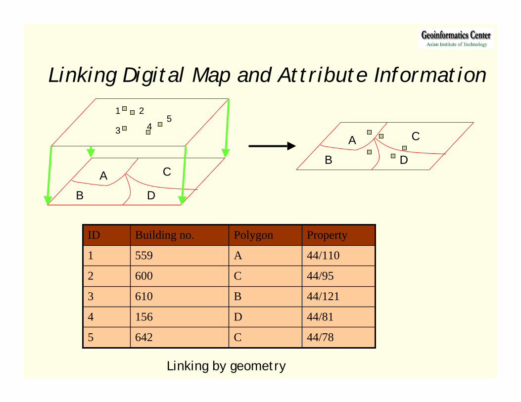
Database and Database Management SystemDatabase :
-Sets of collection of information
-files structured by DBMS and accessed through it
-DBMS located between the physical storage and the user.
Users
DBMS
Files
DBMS :
- Software package for storage, manipulation, retrieval of data from a database.
-To handle complex task of multiple files
-Located between the physical storage and the user.
Interactive questions
Questions translation
Database Process
Management of stored data
System Catalog Database
Database and Database Management System

Relational Database structure
44/19298
44/50256
44/110234
TypeYearOwnerpropertyBuilding ID
44/19
44/110
44/50
property
33 …6400John
AddressAreaOwner

-Geographical object in a record
-Attribute in in a set of fields
-Three basic attributes
primary key
relational join
normal forms
-most frequently used for attribute data
-simple, flexible structures
Relational Database structure

-search time is longer
-collection of large number of table for complex relationships
-Stores single value for each cell
Relational Database structure

1. Database file handling2. Selection 3. Preparation of Sub-Set4. Database query 5. Calculation
ExerciseExercise

1.Database file handling1.Database file handling
1.1 Loading existing data
1.2 Creating point data
1.3 Input / Edit attribute data
1.4 Join tables
1.5 Link tables

-Double click the icon or go to Menu Start menu
-Click at Add Theme icon
-Select theme name “district.shp” then click OK.
1.1 Loaded existing data

-Open attribute table oftheme “District.shp”
Activate theme
Click

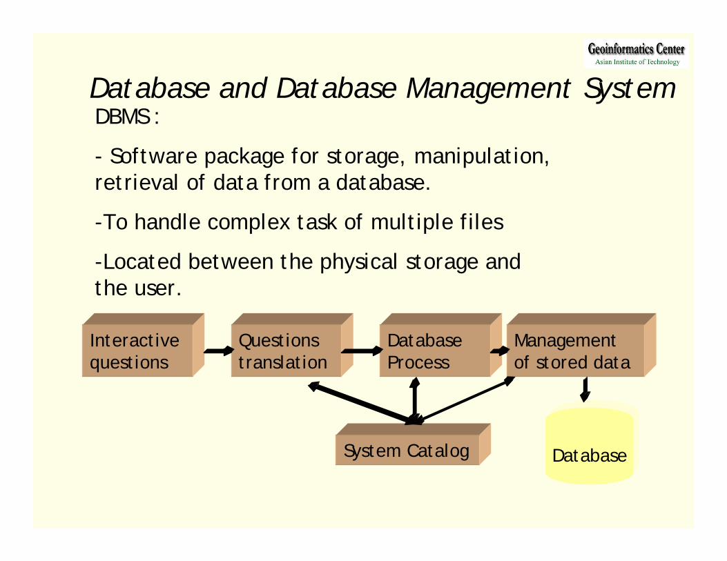
1.2 Creating point data
- Click at Table icon then click Add button- Select a table file name “dh.dbf”
Click
Click
- Activate View window- Go to View menu and select Add Event Theme- Choose table name“dh.dbf” and X,Y coordinate

- Go to Theme menu and select Convert to Shapefile- Navigate the working directory and set a new name
“district_hospital” and click OK

1.3 Input / Edit attribute data
- Open table of “District_hospital.shp”- In Table menu, select Start Editing
- Click at field name “Dcode”- Then click Sort Ascending button

- Select Edit button and click in Dname at Dcode = 1302- Type new Dname to “OUTHOUMPHONE”
- Edit Dname to Dcode number 1304 and 1306 as followingDcode 1304 Dname “PHIN” Dcode 1306 Dname “NONG”
Edit button

- Select Add Field in Edit menu- Select Name and Type of Field- Click OK
- Click at Pcode field name- Select Calculate button- In Field Calculator windowtype “13” then Click OK
- Save Edits and Stop Editing in Table menu
Calculate

1.4 Join tables
- Select Table icon - Click Add button- Select a table file name “soc-eco.dbf”
- Click OK

-Open attribute table of theme “District.shp”-Click Dcode filed name of “Soc-eco.dbf” then Click Dcode filed name of “District.dbf”
- To join two table , Click Join button

- Check attribute table of “District.shp” with new joined table
- To cancel joined table, click Remove All Joins inTable Menu.
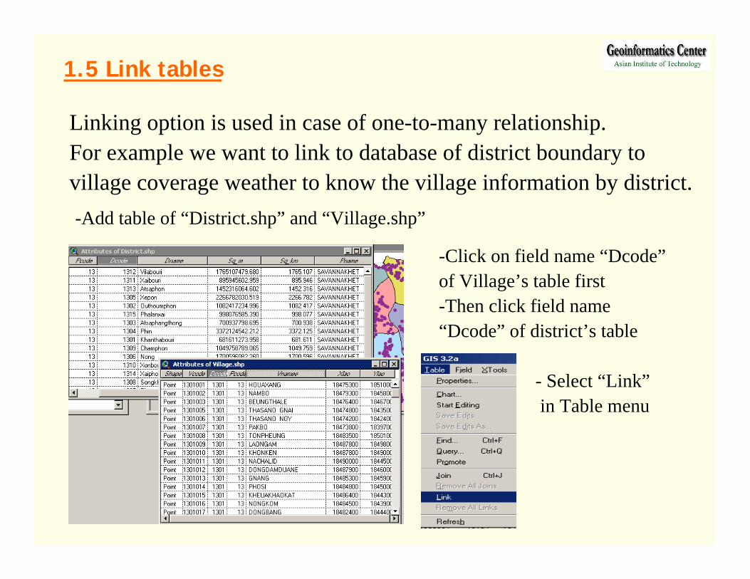
1.5 Link tables
Linking option is used in case of one-to-many relationship.For example we want to link to database of district boundary tovillage coverage weather to know the village information by district.-Add table of “District.shp” and “Village.shp”
-Click on field name “Dcode”of Village’s table first-Then click field name “Dcode” of district’s table
- Select “Link”in Table menu

Two tables are linked togetherthen we can select a record of district-Click Dcode = 1306 in district’s table-Automatically select to records ofVillage which use same district’s code
Number of villages fall in Nong’s district

2. Selection2. Selection
2.1 Identify features
2.2 Select features
2.3 Select records
2.4 Select by themes

2.1 Identify features
-Activate theme name “District.shp”-Click Identify button then click on a feature of district theme
ClickAll informationincluded joined data

2.2 Select features
-Click Select Feature button-Clicking on a feature of district theme
-Open table of district.shp-Click Promote button
to make the selectedrecord shows on top.

-Activate “District.shp” Table
-Click Select button
-Clicking on records
which Dcode = 1301 to
1305. Hold SHIFT key
to select many records
-Try a set of Selection Tool
2.3 Select records

2.4 Select by themes
-Select district name“Khanthabouri”-Add theme“Village.shp”-Go to theme menu,Select By Theme
-Activate “Village” theme-Choose input options asbelow
-Then click New Set-Open table of “Village” and checknumber of villages within the district
3. Preparation of Subset3. Preparation of Subset
3.1 Creating subset shapefiles3.2 Creating subset databasefiles
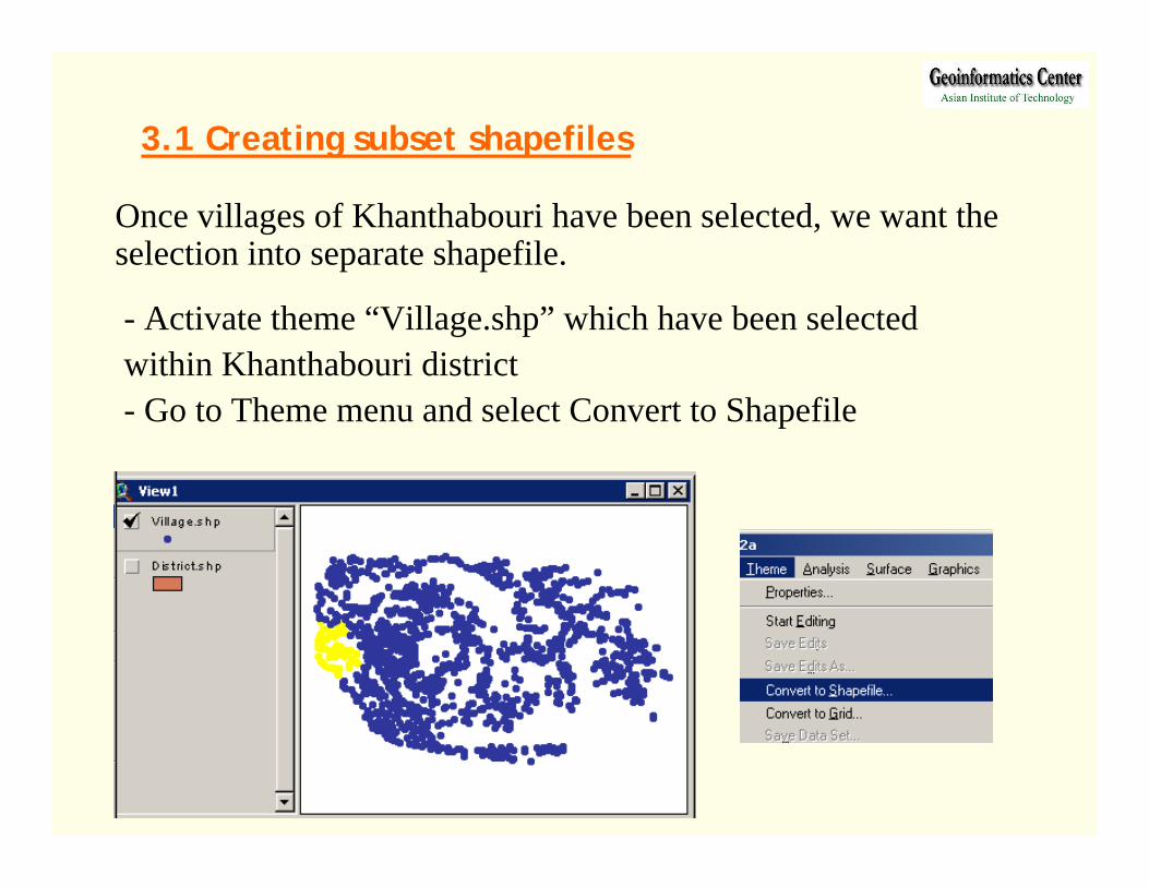
3.1 Creating subset shapefiles
Once villages of Khanthabouri have been selected, we want the selection into separate shapefile.
- Activate theme “Village.shp” which have been selected within Khanthabouri district- Go to Theme menu and select Convert to Shapefile
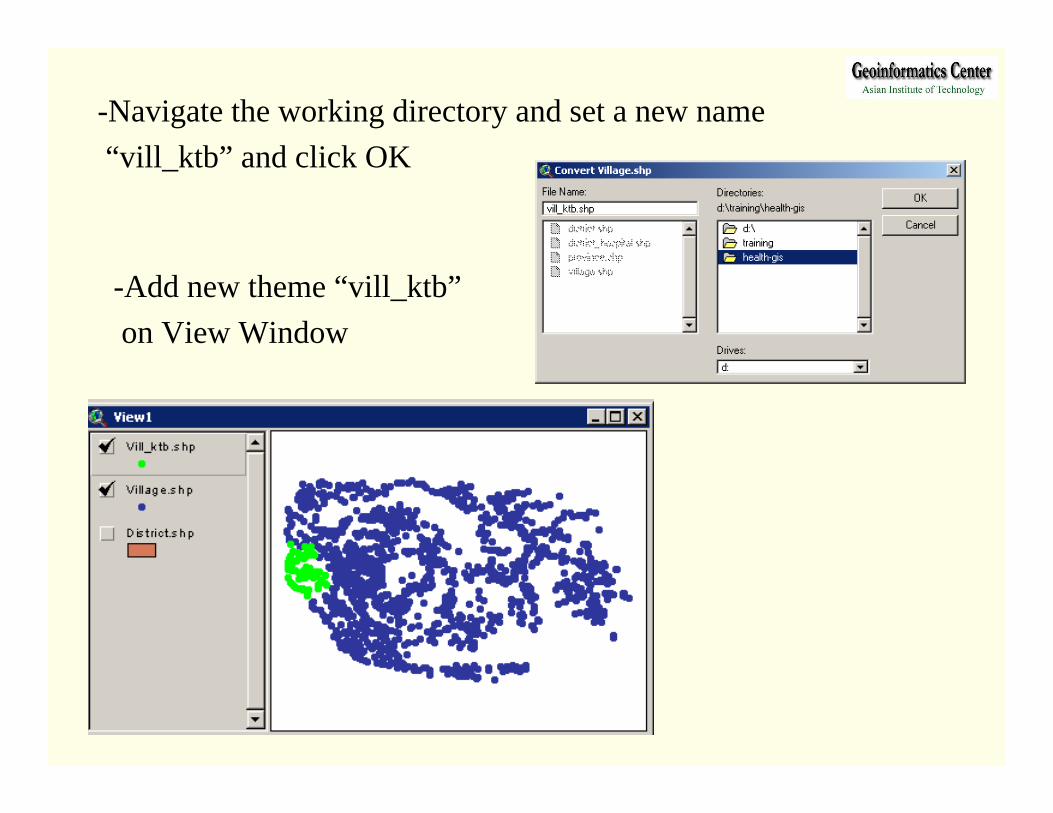
-Navigate the working directory and set a new name“vill_ktb” and click OK
-Add new theme “vill_ktb” on View Window

3.2 Creating subset databasefiles
This step we will create subset database file of population for Khanthabouri district.
-Add Theme name “pop95_vill.shp and “district.shp”-Select Kanthabouri district feature-Select “pop95_vill” feature within the distict

-Open the selected“Pop95_vill” table-Select Export fromFile menu-Choose dBase as Export format, Click OK-Navigate to workingdirectory and input a newname, Click OK

-Add table “Pop95_ktb.dbf” and open table of “Vill_ktb.shp” theme-Join two table and save as a new shapefile (Covert to Shapefile)

4. Database query4. Database query
4.1 Build query expressions4.2 Database query ( single/ multiple )