Getis - Introduction to Geography 14th Edition c2014...
29
45 CHAPTER 3 CHAPTER OUTLINE 3.1 Earth Materials Igneous Rocks Sedimentary Rocks Metamorphic Rocks 3.2 Geologic Time 3.3 Movements of the Continents 3.4 Tectonic Forces Diastrophism Broad Warping Folding Faulting Volcanism 3.5 Gradational Processes Weathering Mechanical Weathering Chemical Weathering Mass Movement Erosional Agents and Deposition Running Water Stream Landscapes Groundwater Glaciers Waves, Currents, and Coastal Landforms Wind 3.6 Landform Regions SUMMARY OF KEY CONCEPTS KEY WORDS THINKING GEOGRAPHICALLY Mitten Buttes, Monument Valley, Navajo Tribal Park, UT/AZ. © Doug Sherman, Geofile 2013
Transcript of Getis - Introduction to Geography 14th Edition c2014...
45
C H A P T E R 3
C H A P T E R O U T L I N E 3.1 Earth Materials
Igneous RocksSedimentary RocksMetamorphic Rocks
3.2 Geologic Time 3.3 Movements of the Continents 3.4 Tectonic Forces
DiastrophismBroad WarpingFoldingFaultingVolcanism
3.5 Gradational ProcessesWeathering
Mechanical WeatheringChemical Weathering
Mass MovementErosional Agents and Deposition
Running WaterStream LandscapesGroundwaterGlaciersWaves, Currents, and Coastal LandformsWind
3.6 Landform RegionsSUMMARY OF KEY CONCEPTSKEY WORDSTHINKING GEOGRAPHICALLY
Mitten Buttes, Monument Valley, Navajo Tribal Park, UT/AZ. © Doug Sherman, Geofile 2013
get22880_ch03_045-073.indd 45get22880_ch03_045-073.indd 45 9/13/13 4:28 PM9/13/13 4:28 PM
Final PDF to printer

46 Chapter 3
A lthough too early for sunbathers and snorkelers, the Hawaiian Islands will have a new island to add to their collection, which
contains such scenic beauties as Oahu, Maui, and Kauai. It is Loihi, 0.8 kilometer (0.5 mi) below sea level, just 27 kilometers (17 mi) from the big island of Hawaii. Because the speed of its ascent must be measured in geologic time, it probably will not appear above the water surface for another million or so years. It is a good example, however, of the ceaseless changes that take place on the earth’s sur-face. As the westernmost of the islands erode and sink below sea level, new islands arise at the eastern end. In Loihi’s most recent explosion in 1996, scientists feared that a giant wave would be set off at the surface that could devastate the islands, including the city of Honolulu and popular Waikiki Beach. Fortunately, this was not the case.
Humans on their trip through life continuously are in touch with the ever-changing, active, moving physical environment. Most of the time, we are able to live comfortably with the changes, but when a freeway is torn apart by an earthquake, or fl oodwaters force us to abandon our homes, we suddenly realize that we spend a good portion of our lives trying to adapt to the challenges the physical environment has for us.
For the geographer, things just will not stand still—not only little things, such as icebergs or new islands rising out of the sea, or big ones, such as exploding volcanoes changing their shape and form, but also giant things, such as continents that wander about like nomads and ocean basins that expand, contract, and split in the middle like worn-out coats.
Geologic time is long, but the forces that give shape to the land are timeless and constant. Processes of creation and destruction are continually at work to fashion the seemingly eternal structure upon which humans live and work. Two types of forces interact to pro-duce those infi nite local variations in the surface of the earth called landforms: (1) forces that push, move, and raise the earth’s surface and (2) forces that scour, wash, and wear down the surface. Moun-tains rise and are then worn away. The eroded materials—soil,
sand, pebbles, rocks—are transported to new locations and help create new landforms. How long these processes have worked, how they work, and their effects are the subject of this chapter.
Much of the research needed to create the story of land-forms results from the work of geomorphologists. A branch of the fi elds of geology and physical geography, geomorphology is the study of the origin, characteristics, and development of landforms. It empha-sizes the study of the various processes that create landscapes. Geo-morphologists examine the erosion, transportation, and deposition of materials and the interrelationships among climate, soils, plant and animal life, and landforms.
In a single chapter, we can only begin to explore the many and varied contributions of geomorphologists. After discussing the contexts within which landform change takes place, we consider the forces that are building up the earth’s surface and then review the forces wearing it down.
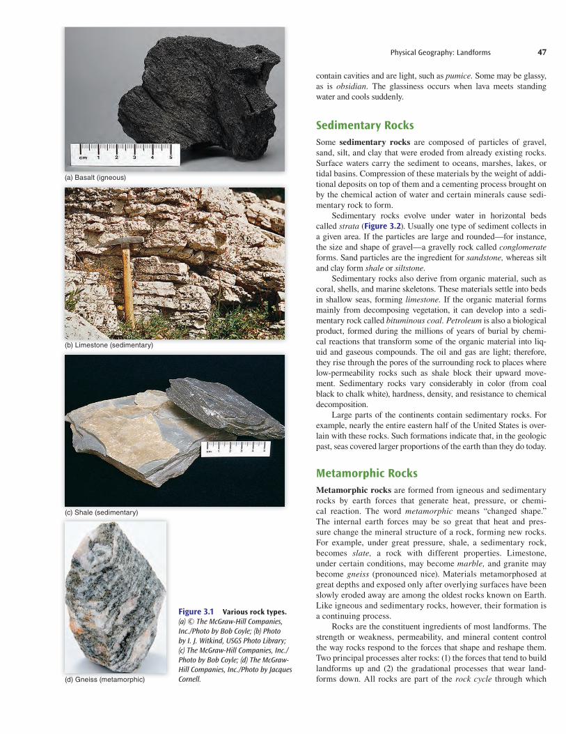
3.1 Earth MaterialsThe rocks of the earth’s crust vary according to mineral com-position. Rocks are composed of particles that contain various combinations of such common elements as oxygen, silicon, alu-minum, iron, and calcium, together with less-abundant elements. A particular chemical combination that has a hardness, density, and defi nite crystal structure of its own is called a mineral. Some well-known minerals are quartz, feldspar, and micas. Depending on the nature of the minerals that form them, rocks are hard or soft, more or less dense, one color or another, or chemically stable or not. While some rocks resist decomposition, others are very easily broken down. Among the more common varieties of rock are granites, basalts, limestones, sandstones, and slates.
Although one can classify rocks according to their physical properties, the more common approach is to classify them by the way they formed. The three main groups of rock are igneous, sedi-mentary, and metamorphic.
Igneous RocksIgneous rocks are formed by the cooling and solidifi cation of molten rock. Openings in the crust give molten rock an oppor-tunity to fi nd its way into or onto the crust. When the molten rock cools, it solidifi es and becomes igneous rock. The name for underground molten rock is magma; aboveground, it is lava. Intrusive igneous rocks are formed below ground level by the solidifi cation of magma, whereas extrusive igneous rocks are created above ground level by the solidifi cation of lava (Figure 3.1).
The composition of magma and lava and, to a limited extent, the rate of cooling determine the minerals that form. The rate of cooling is mainly responsible for the size of the crystals. Large crys-tals of quartz—a hard mineral—form slowly beneath the surface of the earth. When combined with other minerals, quartz forms the intrusive igneous rock called granite.
The lava that oozes out onto the earth’s surface and makes up a large part of the ocean basins becomes the extrusive igneous rock called basalt, the most common rock on the earth’s surface. If, instead of oozing, the lava erupts from a volcano crater, it may cool very rapidly. Some of the igneous rocks formed in this manner
L E A R N I N G O B J E C T I V E SAfter studying this chapter you should be able to:
3.1 Characterize the three classes of rock.
3.2 Defi ne folding, joint, and faulting.
3.3 Illustrate how plate tectonics relate to earthquakes.
3.4 Explain how a tsunami originates.
3.5 Compare the effect of mechanical and chemical weathering on landforms.
3.6 Compare the effect of groundwater erosion with that of surface water erosion.
3.7 Relate how glaciers form and how their erosion creates landscapes.
3.8 Defi ne landform features such as deltas, alluvial fans, natural levees, and moraines.
3.9 Understand the landform changes due to waves, currents, and wind.
get22880_ch03_045-073.indd 46get22880_ch03_045-073.indd 46 9/3/13 6:46 PM9/3/13 6:46 PM
Final PDF to printer
Physical Geography: Landforms 47
contain cavities and are light, such as pumice. Some may be glassy, as is obsidian. The glassiness occurs when lava meets standing water and cools suddenly.
Sedimentary RocksSome sedimentary rocks are composed of particles of gravel, sand, silt, and clay that were eroded from already existing rocks. Surface waters carry the sediment to oceans, marshes, lakes, or tidal basins. Compression of these materials by the weight of addi-tional deposits on top of them and a cementing process brought on by the chemical action of water and certain minerals cause sedi-mentary rock to form.
Sedimentary rocks evolve under water in horizontal beds called strata (Figure 3.2). Usually one type of sediment collects in a given area. If the particles are large and rounded—for instance, the size and shape of gravel—a gravelly rock called conglomerateforms. Sand particles are the ingredient for sandstone, whereas silt and clay form shale or siltstone.
Sedimentary rocks also derive from organic material, such as coral, shells, and marine skeletons. These materials settle into beds in shallow seas, forming limestone. If the organic material forms mainly from decomposing vegetation, it can develop into a sedi-mentary rock called bituminous coal. Petroleum is also a biological product, formed during the millions of years of burial by chemi-cal reactions that transform some of the organic material into liq-uid and gaseous compounds. The oil and gas are light; therefore, they rise through the pores of the surrounding rock to places where low-permeability rocks such as shale block their upward move-ment. Sedimentary rocks vary considerably in color (from coal black to chalk white), hardness, density, and resistance to chemical decomposition.
Large parts of the continents contain sedimentary rocks. For example, nearly the entire eastern half of the United States is over-lain with these rocks. Such formations indicate that, in the geologic past, seas covered larger proportions of the earth than they do today.
Metamorphic RocksMetamorphic rocks are formed from igneous and sedimentary rocks by earth forces that generate heat, pressure, or chemi-cal reaction. The word metamorphic means “changed shape.” The internal earth forces may be so great that heat and pres-sure change the mineral structure of a rock, forming new rocks. For example, under great pressure, shale, a sedimentary rock, becomes slate, a rock with different properties. Limestone, under certain conditions, may become marble, and granite may become gneiss (pronounced nice). Materials metamorphosed at great depths and exposed only after overlying surfaces have been slowly eroded away are among the oldest rocks known on Earth. Like igneous and sedimentary rocks, however, their formation is a continuing process.
Rocks are the constituent ingredients of most landforms. The strength or weakness, permeability, and mineral content control the way rocks respond to the forces that shape and reshape them. Two principal processes alter rocks: (1) the forces that tend to build landforms up and (2) the gradational processes that wear land-forms down. All rocks are part of the rock cycle through which
(a) Basalt (igneous)
(b) Limestone (sedimentary)
(c) Shale (sedimentary)
Figure 3.1 Various rock types.(a) © The McGraw-Hill Companies, Inc./Photo by Bob Coyle; (b) Photo by I. J. Witkind, USGS Photo Library; (c) The McGraw-Hill Companies, Inc./Photo by Bob Coyle; (d) The McGraw-Hill Companies, Inc./Photo by Jacques Cornell.(d) Gneiss (metamorphic)
get22880_ch03_045-073.indd 47get22880_ch03_045-073.indd 47 9/3/13 6:46 PM9/3/13 6:46 PM
Final PDF to printer

48 Chapter 3
acceptance in recent years by earth scientists of the idea of moving continents. Wegener’s ideas were a forerunner of the broader plate tectonics theory, which is explained in the next section, “Move-ments of the Continents.”
3.3 Movements of the ContinentsThe landforms mapped by cartographers are only the surface features of a thin cover of rock, the earth’s crust (Figure 3.4). Above the earth’s interior is a partially molten layer called the asthenosphere. It supports a thin but strong solid shell of rocks called the lithosphere, of which the outer, lighter portion is the earth’s crust. The crust consists of one set of rocks found below the oceans and another set that makes up the continents.
The lithosphere is broken into about 12 large and many small, rigid plates, each of which, according to the theory of plate
old rocks are continually transformed into new ones by these pro-cesses. No rocks have been preserved unaltered throughout the earth’s history. Figure 3.3 shows the rock cycle and the processes that shaped it.
3.2 Geologic TimeThe earth was formed about 4.5 billion years ago. When we think of a person who lives to be 100 years old as having had a long life, it becomes clear that the earth is incredibly old indeed. Because our usual concept of time is dwarfed when we speak of billions of years, it is useful to compare the age of the earth with something more familiar.
Imagine that the height of the Sears Tower in Chicago repre-sents the age of the earth. The tower is 110 stories, or 412 meters (1447 ft), tall. In relative terms, even the thickness of a piece of paper laid on the rooftop would be too great to represent an aver-age person’s lifetime. Of the total building height, only 4.8 stories represent the 200 million years that have elapsed since the present ocean floors began to form.
At this moment, the landforms on which we live are ever so slightly being created and destroyed. The processes involved have been in operation for so long that any given location most likely was the site of ocean and land at a number of different times in its past. Many of the landscape features on Earth today can be traced back millions of years. The processes responsible for building up and tearing down those features are occurring simultaneously, but usually at different rates.
Since the 1960s, scientists have developed a useful framework within which one can best study our constantly changing physi-cal environment. Their work is based on the early 20th-century geologic studies of Alfred Wegener, who proposed the theory of continental drift. He believed that all landmasses were once united in one supercontinent, which Wegener named Pangaea (“all Earth”), and that over many millions of years the continents broke away from one another, slowly drifting to their current positions. Although Wegener’s theory was initially rejected outright, new evi-dence and new ways of rethinking old knowledge have led to wide
Figure 3.2 The sedimentary rocks of the Grand Canyon in Arizona are evident in this photograph. © John Wang/Getty RF.
Magma
Metamorphic rock
SedimentSedimentary rock
Igneous rock
d
c
b
a) Cementation and compaction (lithification)b) Heat and pressurec) Weathering, transportation, depositiond) Cooling and solidification
c
a
c
b
Figure 3.3 The rock cycle. Source: Adapted from McConnell et al., The Good Earth, p. 209, Checkpoint 7.22, © McGraw-Hill, 2008.
Continent
OceanOceanic
crust
Continentalcrust
Mantle
Lithosphere(solid)
Asthenosphere(partially molten)
Figure 3.4 The outer zones of the earth (not to scale). The lithosphere includes the crust. The asthenosphere lies below the lithosphere.
get22880_ch03_045-073.indd 48get22880_ch03_045-073.indd 48 9/3/13 6:46 PM9/3/13 6:46 PM
Final PDF to printer
Physical Geography: Landforms 49
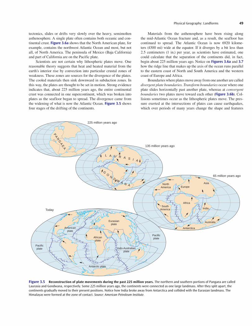
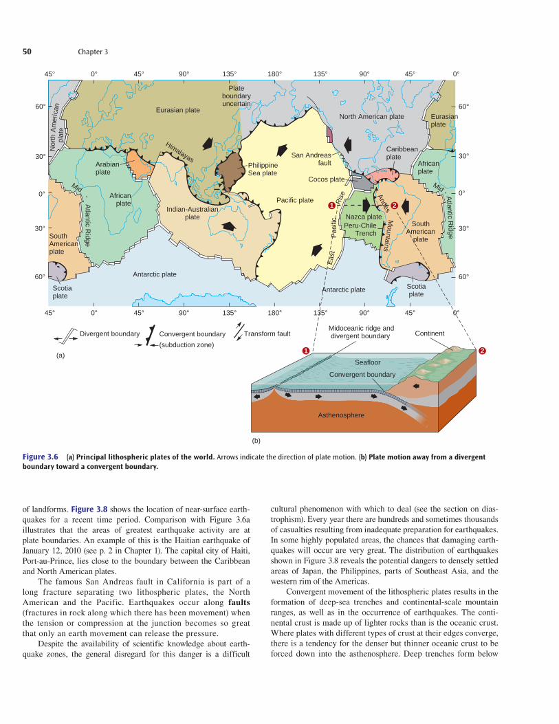
Materials from the asthenosphere have been rising along the mid-Atlantic Ocean fracture and, as a result, the seafloor has continued to spread. The Atlantic Ocean is now 6920 kilome-ters (4300 mi) wide at the equator. If it diverges by a bit less than 2.5 centimeters (1 in.) per year, as scientists have estimated, one could calculate that the separation of the continents did, in fact, begin about 225 million years ago. Notice on Figures 3.6a and 3.7 how the ridge line that makes up the axis of the ocean runs parallel to the eastern coast of North and South America and the western coast of Europe and Africa.
Boundaries where plates move away from one another are called divergent plate boundaries. Transform boundaries occur where one plate slides horizontally past another plate, whereas at convergent boundaries two plates move toward each other ( Figure 3.6b). Col-lisions sometimes occur as the lithospheric plates move. The pres-sure exerted at the intersections of plates can cause earthquakes, which over periods of many years change the shape and features
tectonics, slides or drifts very slowly over the heavy, semimolten asthenosphere. A single plate often contains both oceanic and con-tinental crust. Figure 3.6a shows that the North American plate, for example, contains the northwest Atlantic Ocean and most, but not all, of North America. The peninsula of Mexico (Baja California) and part of California are on the Pacific plate.
Scientists are not certain why lithospheric plates move. One reasonable theory suggests that heat and heated material from the earth’s interior rise by convection into particular crustal zones of weakness. These zones are sources for the divergence of the plates. The cooled materials then sink downward in subduction zones. In this way, the plates are thought to be set in motion. Strong evidence indicates that, about 225 million years ago, the entire continental crust was connected in one supercontinent, which was broken into plates as the seafloor began to spread. The divergence came from the widening of what is now the Atlantic Ocean. Figure 3.5 shows four stages of the drifting of the continents.
PA
NG
AE
A
225 million years ago
135 million years ago
65 million years ago
Europe Asia
Africa
African plate
Pacific plate
Pacific plate
Eurasian plate
Indo-Australian plate
India
Australia
Antarctica
South America
North America
American plate
Antarctic plate
Today
L A U R A S I A
GO
ND
WA N A
Figure 3.5 Reconstruction of plate movements during the past 225 million years. The northern and southern portions of Pangaea are called Laurasia and Gondwana, respectively. Some 225 million years ago, the continents were connected as one large landmass. After they split apart, the continents gradually moved to their present positions. Notice how India broke away from Antarctica and collided with the Eurasian landmass. The Himalayas were formed at the zone of contact. Source: American Petroleum Institute.
get22880_ch03_045-073.indd 49get22880_ch03_045-073.indd 49 9/3/13 6:46 PM9/3/13 6:46 PM
Final PDF to printer
50 Chapter 3
of landforms. Figure 3.8 shows the location of near-surface earth-quakes for a recent time period. Comparison with Figure 3.6a illustrates that the areas of greatest earthquake activity are at plate boundaries. An example of this is the Haitian earthquake of January 12, 2010 (see p. 2 in Chapter 1). The capital city of Haiti, Port-au-Prince, lies close to the boundary between the Caribbean and North American plates.
The famous San Andreas fault in California is part of a long fracture separating two lithospheric plates, the North American and the Pacific. Earthquakes occur along faults (fractures in rock along which there has been movement) when the tension or compression at the junction becomes so great that only an earth movement can release the pressure.
Despite the availability of scientific knowledge about earth-quake zones, the general disregard for this danger is a difficult
cultural phenomenon with which to deal (see the section on dias-trophism). Every year there are hundreds and sometimes thousands of casualties resulting from inadequate preparation for earthquakes. In some highly populated areas, the chances that damaging earth-quakes will occur are very great. The distribution of earthquakes shown in Figure 3.8 reveals the potential dangers to densely settled areas of Japan, the Philippines, parts of Southeast Asia, and the western rim of the Americas.
Convergent movement of the lithospheric plates results in the formation of deep-sea trenches and continental-scale mountain ranges, as well as in the occurrence of earthquakes. The conti-nental crust is made up of lighter rocks than is the oceanic crust. Where plates with different types of crust at their edges converge, there is a tendency for the denser but thinner oceanic crust to be forced down into the asthenosphere. Deep trenches form below
plat
eN
orth
Am
eric
an
Arabianplate
Scotiaplate
Africanplate
Mid - Atlantic R
idge
Eurasian plate
PhilippineSea plate
Pacific plate
Eas
tP
acifi
cR
ise
Cocos plate
Plateboundaryuncertain
Himalayas
Antarctic plate
Antarctic plate
Nazca platePeru-Chile
TrenchSouth
Americanplate
Scotiaplate
Indian-Australianplate
Caribbeanplate
AndesM
ountains
Eurasianplate
Africanplate
45° 0° 45° 90° 135° 180° 135° 45°90° 0°
45° 0° 45° 90° 135° 180° 135° 45°90° 0°
60°
30°
0°
30°
60°60°
30°
0°
30°
60°
Mid - Atlantic R
idge SouthAmericanplate
San Andreasfault
North American plate
Asthenosphere
Seafloor
Midoceanic ridge anddivergent boundary Continent
Convergent boundary
Divergent boundary
(a)
(b)
Convergent boundary
(subduction zone)
Transform fault
1 2
1 2
Figure 3.6 (a) Principal lithospheric plates of the world. Arrows indicate the direction of plate motion. (b) Plate motion away from a divergent boundary toward a convergent boundary.
get22880_ch03_045-073.indd 50get22880_ch03_045-073.indd 50 9/3/13 6:46 PM9/3/13 6:46 PM
Final PDF to printer

Physical Geography: Landforms 51
Figure 3.7 An accurate map of the North Atlantic Ocean seafloor created by the National Oceanic and Atmospheric Administration using gravity measurements taken from satellite readings. The configuration of the seafloor is evidence of the dynamic processes shaping continents and ocean basins. Darker ocean colors indicate greater depth. © David T. Sandwell, 1995. Scripps Institution of Oceanography.
ung
Young volcanoEarthquake epicenter
circum–Pacific Belt
Figure 3.8 Locations of young volcanoes and the epicenters of earthquakes. Notice that they are concentrated at the margins of the lithospheric plates, as comparison with Figure 3.5 reveals. The most important concentration of earthquakes is in the circum-Pacific belt, which encircles the rim of the Pacific Ocean and is popularly known as the “ring of fire.” Volcanoes can also grow in the middle of a plate. The volcanoes of Hawaii, for example, are located in the middle of the Pacific plate. Map plotted by the Environmental Data and Information Service of NOAA; Earthquakes from U.S. Coast and Geodetic Survey.
get22880_ch03_045-073.indd 51get22880_ch03_045-073.indd 51 9/3/13 6:46 PM9/3/13 6:46 PM
Final PDF to printer
52 Chapter 3
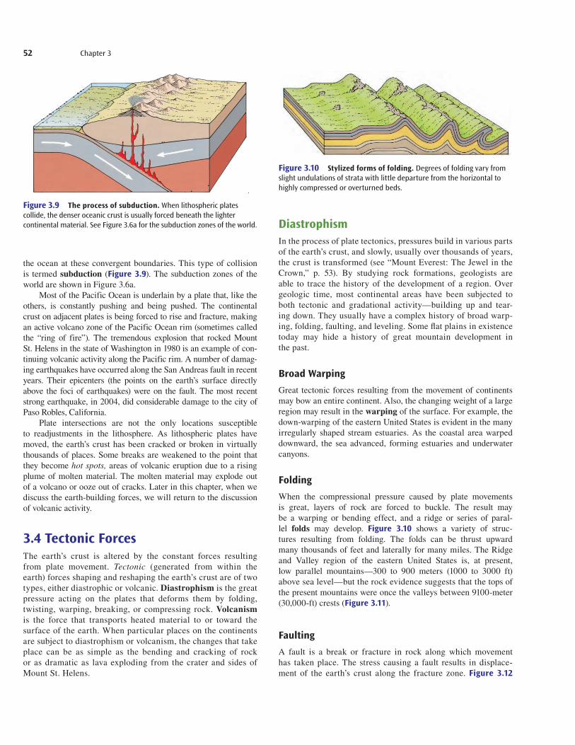
DiastrophismIn the process of plate tectonics, pressures build in various parts of the earth’s crust, and slowly, usually over thousands of years, the crust is transformed (see “Mount Everest: The Jewel in the Crown,” p. 53). By studying rock formations, geologists are able to trace the history of the development of a region. Over geologic time, most continental areas have been subjected to both tectonic and gradational activity—building up and tear-ing down. They usually have a complex history of broad warp-ing, folding, faulting, and leveling. Some fl at plains in existence today may hide a history of great mountain development in the past.
Broad WarpingGreat tectonic forces resulting from the movement of continents may bow an entire continent. Also, the changing weight of a large region may result in the warping of the surface. For example, the down-warping of the eastern United States is evident in the many irregularly shaped stream estuaries. As the coastal area warped downward, the sea advanced, forming estuaries and underwater canyons.
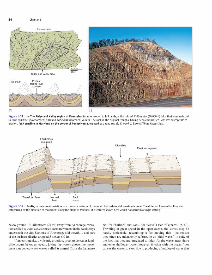
FoldingWhen the compressional pressure caused by plate movements is great, layers of rock are forced to buckle. The result may be a warping or bending effect, and a ridge or series of paral-lel folds may develop. Figure 3.10 shows a variety of struc-tures resulting from folding. The folds can be thrust upward many thousands of feet and laterally for many miles. The Ridge and Valley region of the eastern United States is, at present, low parallel mountains—300 to 900 meters (1000 to 3000 ft) above sea level—but the rock evidence suggests that the tops of the present mountains were once the valleys between 9100-meter (30,000-ft) crests (Figure 3.11).
FaultingA fault is a break or fracture in rock along which movement has taken place. The stress causing a fault results in displace-ment of the earth’s crust along the fracture zone. Figure 3.12
the ocean at these convergent boundaries. This type of collision is termed subduction (Figure 3.9). The subduction zones of the world are shown in Figure 3.6a.
Most of the Pacific Ocean is underlain by a plate that, like the others, is constantly pushing and being pushed. The continental crust on adjacent plates is being forced to rise and fracture, making an active volcano zone of the Pacific Ocean rim (sometimes called the “ring of fire”). The tremendous explosion that rocked Mount St. Helens in the state of Washington in 1980 is an example of con-tinuing volcanic activity along the Pacific rim. A number of damag-ing earthquakes have occurred along the San Andreas fault in recent years. Their epicenters (the points on the earth’s surface directly above the foci of earthquakes) were on the fault. The most recent strong earthquake, in 2004, did considerable damage to the city of Paso Robles, California.
Plate intersections are not the only locations susceptible to readjustments in the lithosphere. As lithospheric plates have moved, the earth’s crust has been cracked or broken in virtually thousands of places. Some breaks are weakened to the point that they become hot spots, areas of volcanic eruption due to a rising plume of molten material. The molten material may explode out of a volcano or ooze out of cracks. Later in this chapter, when we discuss the earth-building forces, we will return to the discussion of volcanic activity.
3.4 Tectonic ForcesThe earth’s crust is altered by the constant forces resulting from plate movement. Tectonic (generated from within the earth) forces shaping and reshaping the earth’s crust are of two types, either diastrophic or volcanic. Diastrophism is the great pressure acting on the plates that deforms them by folding, twisting, warping, breaking, or compressing rock. Volcanism is the force that transports heated material to or toward the surface of the earth. When particular places on the continents are subject to diastrophism or volcanism, the changes that take place can be as simple as the bending and cracking of rock or as dramatic as lava exploding from the crater and sides of Mount St. Helens.
Figure 3.9 The process of subduction. When lithospheric plates collide, the denser oceanic crust is usually forced beneath the lighter continental material. See Figure 3.6a for the subduction zones of the world.
Figure 3.10 Stylized forms of folding. Degrees of folding vary from slight undulations of strata with little departure from the horizontal to highly compressed or overturned beds.
get22880_ch03_045-073.indd 52get22880_ch03_045-073.indd 52 9/3/13 6:46 PM9/3/13 6:46 PM
Final PDF to printer

Physical Geography: Landforms 53
The fastest growing mountain range on Earth happens also to con-tain the world’s tallest set of mountains. Nearly in the center of the Himalayas stands the world’s highest peak, Mount Everest. Currently, Mount Everest is measured as standing 8844 meters (29,010 ft) above sea level. Recent measurements, however, indicate that Mount Ever-est and many of the other peaks, such as K-2, are growing at about 1 centimeter (1/2 in.) a year.
As the mountains build ever higher, their great weight softens underlying materials, causing the mountains to settle. In other words, there are two forces at work. The force building the mountains is that of the Indian plate moving northward, crashing into the Eur-asian plate. The Himalayas, at the edge of the Eurasian plate, react to the great force by pushing higher and higher. But apparently a second force that works against the fi rst keeps mountains on Earth from rising to heights of 15,000 to 18,000 meters (roughly 50,000 to 60,000 ft). One may think of these great mountains as being in a
kind of equilibrium—the bigger they get, the heavier they get, and the more likely they are to sag.
The battle between the two plates began about 45 million years ago. Usually, one plate is forced under the more stationary plate (sub-duction). In this case, however, the rocks of the two plates are similar in weight and density. Thus, subduction has not taken place, and what nor-mally would have been a modest crinkle on the earth’s surface turned into the tallest, most rugged mountain range on Earth. Particularly interesting is one view of the Himalayas. The Indian plate contains the relatively low-elevation Indian subcontinent and, as a result, the view of the Himalayas from the plains of northern India is one of the great sights on Earth. No wonder Mount Everest is the jewel in the mountain climber’s crown. Edmund Hillary and Tenzing Norgay were the fi rst to reach the summit, in 1953. Since then, more than 1500 climbers have reached the top, most of them since 1990; 176 have died attempting to scale Mount Everest.
M O U N T E V E R E S T: T H E J E W E L I N T H E C R O W NJ
© Corbis RF.
diagramatically shows examples of fault types. There may be uplift on one side of the fault or downthrust on the other. In some cases, a steep slope known as a fault escarpment, which may be several hundred feet high and several hundred miles long, is formed. The stress can push one side up and over the other side, or a separation away from the fault may cause the sinking of land, creating a rift valley (Figure 3.13).
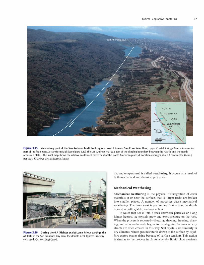
Many fractures are merely cracks (called joints) with little noticeable movement along them. In other cases, however, moun-tains such as the Sierra Nevadas of California have risen as the result of faulting. Sometimes, the movement has been horizontal along the
surface rather than upward or downward. The San Andreas trans-form fault, shown in Figures 3.14 and 3.15, is such a case.
Whenever movement occurs along a fault, or at another point of weakness, an earthquake results. The greater the movement, the greater the magnitude of the earthquake (see “Scaling Earth-quakes,” p. 58). Stress builds in rock as tectonic forces are applied and, when a critical point is finally reached, an earthquake occurs and tension is reduced.
The earthquake that occurred in Alaska on Good Friday in 1964 was one of the strongest measured, with a magnitude of 9.2 on the Richter scale. Although the stress point of that earthquake was
get22880_ch03_045-073.indd 53get22880_ch03_045-073.indd 53 9/3/13 6:46 PM9/3/13 6:46 PM
Final PDF to printer
54 Chapter 3
below ground 121 kilometers (75 mi) away from Anchorage, vibra-tions called seismic waves caused earth movement in the weak clays underneath the city. Sections of Anchorage slid downhill, and part of the business district dropped 3 meters (10 ft).
If an earthquake, a volcanic eruption, or an underwater land-slide occurs below an ocean, jolting the waters above, the move-ment can generate sea waves called tsunami (from the Japanese
tsu, for “harbor,” and nami, for “wave”) (see “Tsunami,” p. 60). Traveling at great speed in the open ocean, the waves may be hardly noticeable, resembling a fast-moving tide—the reason they often are mistakenly referred to as “tidal waves” in spite of the fact that they are unrelated to tides. As the waves near shore and enter shallower water, however, friction with the ocean floor causes the waves to slow down, producing a buildup of water that
Pennsylvania
Ridge and Valley area
Presentground level
2000 feet
30,000 ft
(a)
50 miles
50 km
Figure 3.11 (a) The Ridge and Valley region of Pennsylvania, now eroded to hill lands, is the relic of 9100-meter (30,000-ft) folds that were reduced to form synclinal (downarched) hills and anticlinal (uparched) valleys. The rock in the original troughs, having been compressed, was less susceptible to erosion. (b) A syncline in Maryland on the border of Pennsylvania, exposed by a road cut. (b) © Mark C. Burnett/Photo Researchers.
Fault-blockmountain
Transform fault Normalfault
Rift valley
Faultsteps
Fault escarpment
Figure 3.12 Faults, in their great variation, are common features of mountain belts where deformation is great. The different forms of faulting are categorized by the direction of movement along the plane of fracture. The features shown here would not occur in a single setting.
(b)
get22880_ch03_045-073.indd 54get22880_ch03_045-073.indd 54 9/3/13 6:46 PM9/3/13 6:46 PM
Final PDF to printer

Physical Geography: Landforms 55
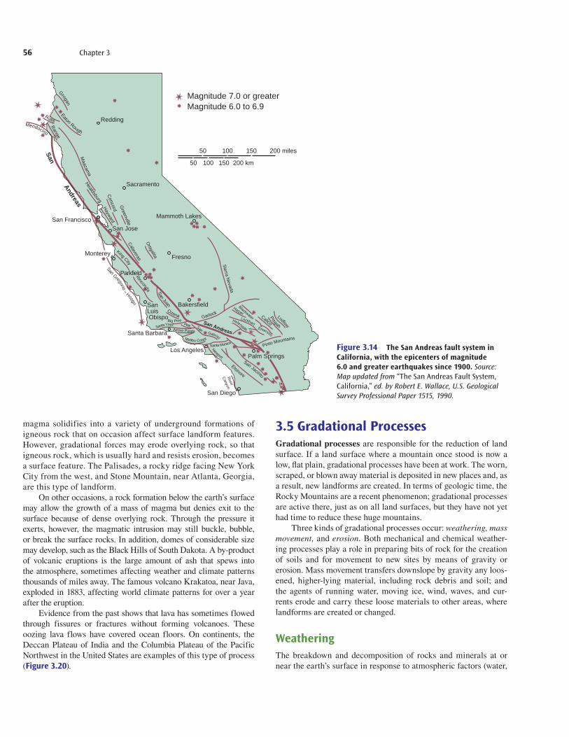
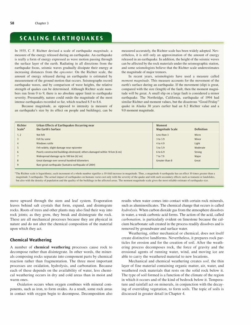
in 2003 (35,000 deaths) and China in 1976 (242,000 deaths). Most earthquakes take place on the Pacific rim (see Figure 3.8), where stress from the converging lithospheric plates is great-est. The Aleutian Islands of Alaska, Japan, Central America, and Indonesia experience a number of moderately severe earth-quakes each year. The Haitian earthquake did massive amounts of damage (see p. 2 in Chapter 1). Major earthquakes in the San Francisco Bay area caused considerable damage ( Figure 3.16). In recent years, major earthquakes and volcanic activity have also occurred in non-Pacific areas, such as Turkey, Iran, and Algeria.
The huge earthquake that struck Kashmir on October 8, 2005, was a reminder that the Himalayas are along the bound-ary of three tectonic plates, making countries all the way from Afghanistan and Pakistan in the west to Myanmar in the east sub-ject to quakes. For further information on earthquakes and other earth processes go to usgs.gov.
VolcanismThe second tectonic force is volcanism. The most likely places through which molten materials can move toward the surface are at or near the intersections of plates. However, other zones, such as hot spots, are also subject to volcanic activity (Figure 3.17). The volcanoes of Hawaii, for example, formed above a relatively sta-tionary hot spot in the earth’s interior.
If sufficient internal pressure forces the magma upward, weaknesses in the crust, or faults, enable molten materials to reach the surface. The material ejected onto the earth’s surface may arrive as a series of explosions, forming a steep-sided cone com-posed of alternate layers of solidified lava and ash and cinders, termed a strato or composite volcano (Figure 3.18a). The eruption may also be without explosions, forming a gently sloping shield volcano (Figure 3.18b).
The major volcanic belt of the world coincides with the major earthquake and fault zones. This belt occurs at the convergence of plates. A second zone of volcanic activity is at diverging plate boundaries, such as in the center of the Atlantic Ocean.
Molten material can either flow smoothly out of a crater or be shot into the air with explosive force. Some relatively quiet volca-noes have long, gentle slopes indicative of smooth flow, whereas explosive volcanoes have steep sides. Steam and gases are con-stantly escaping from the nearly 300 active volcanoes in the world today. The city of Pompeii, Italy, was partially buried under about 5 meters (16 ft) of ash and pumice as a result of the eruption of Mt. Vesuvius in ad 79.
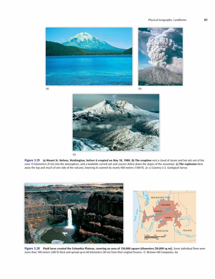
When pressure builds, a crater can become a boiling cauldron with steam, gas, lava, and ash billowing out (Figure 3.19). In the case of Mount St. Helens in 1980, a large bulge had formed on the north slope of the mountain. An earthquake occurred and an explo-sion followed, shooting debris into the air, completely devastating an area of about 400 square kilometers (150 sq mi), causing about 1 centimeter (0.4 in.) of ash to rain down on eastern Washington and parts of Idaho and Montana and reducing the elevation of the mountain by more than 300 meters (1000 ft).
In many cases, the pressure beneath the crust is not intense enough to allow magma to reach the surface. In these instances,
can reach 15 meters (50 ft) or more above sea level. The water sweeps inland with massive force once it hits the shore, particu-larly when the narrowed topography of harbors and inlets focuses the waves into smaller spaces.
Earthquakes occur daily in hundreds of places through-out the world. Most are slight and only noticeable on seismo-graphs, instruments that record seismic waves. But from time to time, large-scale earthquakes occur, such as those in Iran
Mediterranean Sea
Gulf of AqabaPersian Gulf
Rift valley
Volcano
ArabianPeninsula
Red Sea
Gulf of Aden
GulfofSuez
Nile
R
iver
LakeAlbert
LakeTurhana
Lake Victoria
LakeTanganyika
LakeNyasa
Zaire
INDIAN
OCEAN
KaribaLake Madagascar
Zam
bezi
River
EAST AFRICAN RIFT
0 km
0 miles
500
500
Figure 3.13 The rift valleys of East Africa. Great fractures in the earth’s crust resulted in the creation, through subsidence, of an extensive rift valley system (see Figure 3.12) in East Africa. The parallel faults, some reaching more than 610 meters (2000 ft) below sea level, are bordered by steep walls of the adjacent plateau, which rises to 1500 meters (5000 ft) above sea level and from which the structure dropped.
get22880_ch03_045-073.indd 55get22880_ch03_045-073.indd 55 9/3/13 6:46 PM9/3/13 6:46 PM
Final PDF to printer
56 Chapter 3
magma solidifies into a variety of underground formations of igneous rock that on occasion affect surface landform features. However, gradational forces may erode overlying rock, so that igneous rock, which is usually hard and resists erosion, becomes a surface feature. The Palisades, a rocky ridge facing New York City from the west, and Stone Mountain, near Atlanta, Georgia, are this type of landform.
On other occasions, a rock formation below the earth’s surface may allow the growth of a mass of magma but denies exit to the surface because of dense overlying rock. Through the pressure it exerts, however, the magmatic intrusion may still buckle, bubble, or break the surface rocks. In addition, domes of considerable size may develop, such as the Black Hills of South Dakota. A by- product of volcanic eruptions is the large amount of ash that spews into the atmosphere, sometimes affecting weather and climate patterns thousands of miles away. The famous volcano Krakatoa, near Java, exploded in 1883, affecting world climate patterns for over a year after the eruption.
Evidence from the past shows that lava has sometimes flowed through fissures or fractures without forming volcanoes. These oozing lava flows have covered ocean floors. On continents, the Deccan Plateau of India and the Columbia Plateau of the Pacific Northwest in the United States are examples of this type of process (Figure 3.20).
3.5 Gradational ProcessesGradational processes are responsible for the reduction of land surface. If a land surface where a mountain once stood is now a low, fl at plain, gradational processes have been at work. The worn, scraped, or blown away material is deposited in new places and, as a result, new landforms are created. In terms of geologic time, the Rocky Mountains are a recent phenomenon; gradational processes are active there, just as on all land surfaces, but they have not yet had time to reduce these huge mountains.
Three kinds of gradational processes occur: weathering, mass movement, and erosion. Both mechanical and chemical weather-ing processes play a role in preparing bits of rock for the creation of soils and for movement to new sites by means of gravity or erosion. Mass movement transfers downslope by gravity any loos-ened, higher-lying material, including rock debris and soil; and the agents of running water, moving ice, wind, waves, and cur-rents erode and carry these loose materials to other areas, where landforms are created or changed.
WeatheringThe breakdown and decomposition of rocks and minerals at or near the earth’s surface in response to atmospheric factors (water,
Redding
Sacramento
Mammoth LakesSan Francisco
Santa Barbara
Bakersfield
Los AngelesPalm Springs
San Diego
Parkfield
Monterey Fresno
SanLuis Obispo
Grogan Eaton Rough
Russ
Range
Maacam
a
San Andreas
Mendocino
Healdsburg H
ayward
Concord
Greenville
Calaveras
Andreas
San
San Jose
Ortigalita
King City Rinconda San Juan
San Gregorio – Hosgri
Ozena Big Pine
Pine Santa Ynez
Malibu Coast
San Gabriel Santa Monica
Elsinore
Arrovo Parida
Newport San Jacinto R
ose
Canyon
Pinto Mountains
Garlock Blackwater
Harper
Emerson
Lockhart
Ludlow
Pisgah
Calico Helendale
Sierra N
evada
Magnitude 7.0 or greaterMagnitude 6.0 to 6.9
50 100 150 200 miles
200 km50 100 150
Figure 3.14 The San Andreas fault system in California, with the epicenters of magnitude 6.0 and greater earthquakes since 1900. Source: Map updated from “The San Andreas Fault System, California,” ed. by Robert E. Wallace, U.S. Geological Survey Professional Paper 1515, 1990.
get22880_ch03_045-073.indd 56get22880_ch03_045-073.indd 56 9/3/13 6:46 PM9/3/13 6:46 PM
Final PDF to printer
Physical Geography: Landforms 57
air, and temperature) is called weathering. It occurs as a result of both mechanical and chemical processes.
Mechanical WeatheringMechanical weathering is the physical disintegration of earth materials at or near the surface; that is, larger rocks are broken into smaller pieces. A number of processes cause mechanical weathering. The three most important are frost action, the devel-opment of salt crystals, and root action.
If water that soaks into a rock (between particles or along joints) freezes, ice crystals grow and exert pressure on the rock. When the process is repeated—freezing, thawing, freezing, thaw-ing, and so on—the rock begins to disintegrate. Potholes on city streets are often created in this way. Salt crystals act similarly in dry climates, where groundwater is drawn to the surface by capil-lary action (water rising because of surface tension). This action is similar to the process in plants whereby liquid plant nutrients
San Andreas fault
NORTH
AMERICAN
PACIFIC PLATE
200 miles
200 km
PLATE
San Andreas fault
CA
LIFOR
NIA San
Francisco
Los Angeles
Figure 3.15 View along part of the San Andreas fault, looking northward toward San Francisco. Here, Upper Crystal Springs Reservoir occupies part of the fault zone. A transform fault (see Figure 3.12), the San Andreas marks a part of the slipping boundary between the Pacific and the North American plates. The inset map shows the relative southward movement of the North American plate; dislocation averages about 1 centimeter (0.4 in.) per year. © George Gerster/Science Source.
Figure 3.16 During the 6.7 (Richter scale) Loma Prieta earthquake of 1989 in the San Francisco Bay area, the double-deck Cypress Freeway collapsed. © Lloyd Cluff/Corbis.
get22880_ch03_045-073.indd 57get22880_ch03_045-073.indd 57 9/3/13 6:46 PM9/3/13 6:46 PM
Final PDF to printer
58 Chapter 3
move upward through the stem and leaf system. Evaporation leaves behind salt crystals that form, expand, and disintegrate rocks. Roots of trees and other plants may also find their way into rock joints; as they grow, they break and disintegrate the rock. These are all mechanical processes because they are physical in nature and do not alter the chemical composition of the material upon which they act.
Chemical WeatheringA number of chemical weathering processes cause rock to decompose rather than disintegrate. In other words, the miner-als composing rocks separate into component parts by chemical reaction rather than fragmentation. The three most important processes are oxidation, hydrolysis, and carbonation. Because each of these depends on the availability of water, less chemi-cal weathering occurs in dry and cold areas than in moist and warm ones.
Oxidation occurs when oxygen combines with mineral com-ponents, such as iron, to form oxides. As a result, some rock areas in contact with oxygen begin to decompose. Decomposition also
results when water comes into contact with certain rock minerals, such as aluminosilicates. The chemical change that occurs is called hydrolysis. When carbon dioxide gas from the atmosphere dissolves in water, a weak carbonic acid forms. The action of the acid, called carbonation, is particularly evident on limestone because the cal-cium bicarbonate salt created in the process readily dissolves and is removed by groundwater and surface water.
Weathering, either mechanical or chemical, does not itself create distinctive landforms. Nevertheless, it prepares rock par-ticles for erosion and for the creation of soil. After the weath-ering process decomposes rock, the force of gravity and the erosional agents of running water, wind, and moving ice are able to carry the weathered material to new locations.
Mechanical and chemical weathering creates soil, the thin layer of fine material containing organic matter, air, water, and weathered rock materials that rests on the solid rock below it. The type of soil formed is a function of the climate of the region in which it occurs and of the kind of bedrock below it. Tempera-ture and rainfall act on minerals, in conjunction with the decay-ing of overriding vegetation, to form soils. The topic of soils is discussed in greater detail in Chapter 4.
In 1935, C. F. Richter devised a scale of earthquake magnitude, a measure of the energy released during an earthquake. An earthquake is really a form of energy expressed as wave motion passing through the surface layer of the earth. Radiating in all directions from the earthquake focus, seismic waves gradually dissipate their energy at increasing distances from the epicenter. On the Richter scale, the amount of energy released during an earthquake is estimated by measurement of the ground motion that occurs. Seismographs record earthquake waves, and by comparison of wave heights, the relative strength of quakes can be determined. Although Richter scale num-bers run from 0 to 9, there is no absolute upper limit to earthquake severity. Presumably, nature could outdo the magnitude of the most intense earthquakes recorded so far, which reached 8.5 to 8.6.
Because magnitude, as opposed to intensity (a measure of an earthquake’s size by its effect on people and buildings), can be
measured accurately, the Richter scale has been widely adopted. Nev-ertheless, it is still only an approximation of the amount of energy released in an earthquake. In addition, the height of the seismic waves can be affected by the rock materials under the seismographic station, and some seismologists believe that the Richter scale underestimates the magnitude of major tremors.
In recent years, seismologists have used a measure called moment magnitude. This measure accounts for the movement of the earth’s surface during an earthquake. If the movement (slip) is great, compared with the size (length) of the fault, then the moment magni-tude will be great. A small slip on a large fault is considered a minor earthquake. The Northridge, California, earthquake of 1994 had similar Richter and moment values, but the disastrous “Good Friday” quake in Alaska 30 years earlier had an 8.2 Richter value and a 9.0 moment magnitude.
S C A L I N G E A R T H Q U A K E SQ
Richter Scalea
Urban Effects of Earthquakes Occurring near the Earth’s Surface
Moment Magnitude Scale Defi nition
1, 2 Not felt Less than 3 Micro
3 Felt by some 3 to 3.9 Minor
4 Windows rattle 4 to 4.9 Light
5 Felt widely, slight damage near epicenter 5 to 5.9 Moderate
6 Poorly constructed buildings destroyed; others damaged within 10 km (6 mi) 6 to 6.9 Strong
7 Widespread damage up to 100 km (62 mi) 7 to 7.9 Major
8 Great damage over several hundred kilometers Greater than 8 Great
9 Rare great earthquake (Sumatra earthquake of 2004)
a The Richter scale is logarithmic; each increment of a whole number signifies a 10-fold increase in magnitude. Thus, a magnitude 4 earthquake has an effect 10 times greater than a magnitude 3 earthquake. The actual impact of earthquakes on humans varies not only with the severity of the quake and with such secondary effects such as tsunami or landslides, but also with the density of population and the quality of the buildings in the affected areas. The moment magnitude scale gives the most reliable estimate of earthquake size.
get22880_ch03_045-073.indd 58get22880_ch03_045-073.indd 58 9/3/13 6:46 PM9/3/13 6:46 PM
Final PDF to printer

Physical Geography: Landforms 59
Vent partly pluggedwith lava fragments
(a)
Successive layers oflava and ash
Mass MovementThe force of gravity—that is, the attraction of the earth for bodies at or near its surface—is constantly pulling on all materials. The downslope movement of material due to gravity is called mass wasting or mass movement. Because it is more descriptive, this book uses the latter term. Small particles or huge boulders, if not held back by solid rock or other stable material, will fall down slopes. Spectacular acts of mass movement include avalanches and landslides. More widespread, but less noticeable, are mass movements such as soil-creep and the fl ow of mud down hillsides (Figure 3.21). In general, all nonrigid formations, such as water, ice, and wind, move downslope under the infl uence of gravity.
Especially in dry areas, a common but very dramatic landform created by the accumulation of rock particles at the base of hills and mountains is talus, pictured in Figure 3.21a. As pebbles, particles of rock, or even larger stones break away from exposed bedrock on a mountainside because of weathering, the masses fall and accumu-late, producing large, conelike landforms. The larger rocks travel
farther than the fine-grained sand particles, which remain near the top of the slope.
Erosional Agents and DepositionErosional agents, such as wind, water, and glaciers, carve already existing landforms into new shapes. Fast-moving agents carry debris, and slow-moving agents drop it. The material that has been worn, scraped, or blown away is deposited in new places, and new landforms are created. Each erosional agent is associated with a distinctive set of landforms.
Running WaterRunning water is a powerful erosional agent. Water, whether fl ow-ing across land surfaces or in stream channels, plays an enormous role in wearing down and building up landforms.
22°
20°
22°N lat.
20°
160°W long. 158° 156°
160°
(b)
2.7–3.4 m.y.
2.2–2.5 m.y.Kauai OahuMolokai
Hawaii PlumeunderLoihi
158° 156°
154°
154°
1.3–1.5 m.y.
0.8 m.y.
0–1 m.y.
Plate movement
Hot spot 3.8–5.6 m.y. ago
Maui
1.2–1.3 m.y.
1.8 m.y.
Mantleplume
Hot spot
Progressivelyolder
Ocean
(a)
Figure 3.17 (a) Plumes, narrow columns of hot mantle rock, can form “hot spots” of volcanism on the earth’s surface. Some plumes rise beneath the centers of oceanic plates rather than at their intersections. A plume under Hawaii rises in the middle of the Pacific plate. As the plate moved over the plume, a chain of volcanoes formed. Each was carried away from the hot spot as the Pacific plate moved northwestward. (b) Ages of volcanic rock in the Hawaiian islands. Note that the volcanoes become progressively older to the northwest. M.Y. means million years. The island of Hawaii contains two active volcanoes, shown by red dots, Mauna Loa and Mauna Kea.
(b)
New lava
Layersof basalt
Feeders
Figure 3.18 (a) Composite volcanoes, such as the one diagrammed, are composed of alternate layers of solidified lava and of ash and cinders. Sudden decompression of gases contained within lavas results in explosions of rock material to form ashes and cinders. (b) Cutaway view of a shield volcano. Composed of solidified lava flows, shield volcanoes are broad and gently sloping.
get22880_ch03_045-073.indd 59get22880_ch03_045-073.indd 59 9/3/13 6:46 PM9/3/13 6:46 PM
Final PDF to printer
1. Seismic event or displacement sends shock waves outward.
2. Initial waves travel very fast, but are only a few feet in height.
3. Waves travel through shallower depths as they approach the coast.
4. Waves decrease in speed and increase in height.
5. Tsunami waves hit shores, depositing water and debris.
Sea level
60 Chapter 3
The Japanese earthquake of March 11, 2011, registered magni-tude 9.0 on the Richter scale (greater than 8 on the moment mag-nitude scale) and was responsible for tsunami as high as a 10-story building (40.5 m or 133 ft). Over 15,000 people died, and about 1 million buildings were either damaged or destroyed. The tsunami caused the Fukushima Daiichi nuclear disaster. In like manner but resulting in an even greater loss of life was the Indian Ocean tsu-nami of December 26, 2004, in which 283,000 people were killed. The effects of the Indian Ocean tsunami were felt mainly along the coasts of Indonesia—the island of Sumatra, in particular—Thailand, Sri Lanka, India, and South Africa. Images of the city of Banda Aceh, at the northern tip of Sumatra, show the area several months before the tsunami struck and two days afterward.
Tsunami are generated by an underwater seismic disturbance such as a submarine earthquake, eruption, or landslide. In the Indian Ocean case, water rushed in to fi ll the depression caused by the fall-ing away of the ocean bottom, a 9.2 magnitude earthquake. The quake occurred along a 1300-kilometer (800-mi) boundary between the Indian-Australian tectonic plate and the Eurasian plate, pushing the former some 15 meters (50 ft) beneath the latter. At fi rst, water was drawn out from the coasts and then rushed back in as tsunami. In the Japan case, subduction at the boundary between the Pacifi c plate and the Eurasian plate caused by the earthquake forced the seafl oor to
rise, pushing water in all directions. The resulting tsunami was dev-astating. Entire towns in Japan were destroyed. Places as far away as British Columbia, Washington, and Oregon were hit by waves as high as 2.4 meters (8 ft). Damaged materials washed ashore on North America’s west coast. In both cases, the initial waves trav-eled very fast, about the speed of a jet plane (640 km or 440 mi per hour), but were not very high. As the waves approached land and the water became shallower, their speed decreased to about 48 kilometers (30 mi) per hour, but their height increased. The water came ashore with terrifi c force. One cubic meter of water weighs nearly a ton. Trees, automobiles, pieces of roadway, or buildings became lethal projectiles as the rushing water pushed inland, inundating low-lying areas along the shore.
In an attempt to minimize loss of life in Pacifi c coastal com-munities, the U.S. Coast and Geodetic Survey established a tsunami early warning system in 1948. Any major seismic disturbance in the Pacifi c region that is capable of generating tsunami is reported to the Tsunami Warning Center in Honolulu. If tsunami are detected, the center relays information about their source, speed, and esti-mated time of arrival to low-lying coastal communities in danger. No doubt this system saved many lives in Japan. It was the Indian Ocean tsunami that prompted the creation of an Indian Ocean tsunami warning system.
T S U N A M I
Satellite images of Banda Aceh on Sumatra (a) on June 23, 2004 and (b) two days after the tsunami of December 25. © Digital Globe.
(b)(a)
get22880_ch03_045-073.indd 60get22880_ch03_045-073.indd 60 9/3/13 6:46 PM9/3/13 6:46 PM
Final PDF to printer
Physical Geography: Landforms 61
Figure 3.19 (a) Mount St. Helens, Washington, before it erupted on May 18, 1980. (b) The eruption sent a cloud of steam and hot ash out of the cone 15 kilometers (9 mi) into the atmosphere, and a landslide carried ash and coarser debris down the slopes of the mountain. (c) The explosion blew away the top and much of one side of the volcano, lowering its summit by nearly 400 meters (1300 ft). (a–c) Courtesy U.S. Geological Survey.
WA S H I N G TO N
I D A H OO R E G O N
Columbia
Snake
R.
SnakeRiver
Columbia
Plateau
Lavas
0 miles
0 km
100 200
200
John Day R.
Salmon R.R.
R.
Pac
ific
Willa
met
te
Des
chut
es
Oce
an
Riv
er
Figure 3.20 Fluid lavas created the Columbia Plateau, covering an area of 130,000 square kilometers (50,000 sq mi). Some individual flows were more than 100 meters (300 ft) thick and spread up to 60 kilometers (40 mi) from their original fissures. © McGraw-Hill Companies, Inc.
(b)(a)
(c)
get22880_ch03_045-073.indd 61get22880_ch03_045-073.indd 61 9/3/13 6:47 PM9/3/13 6:47 PM
Final PDF to printer

62 Chapter 3
Figure 3.21 (a) Rockfall from this butte has created talus, an accumulation of broken rock at the base of a cliff. (b) Creeping soil has caused trees to tilt. (a) © Robert N. Wallen; (b) Courtesy of Victoria Getis.
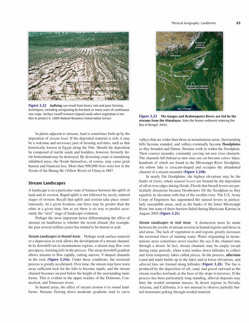
Running water’s ability to erode depends upon several factors: (1) the amount of precipitation; (2) the length and steepness of the slope; and (3) the kind of rock and vegetative cover. Steeper slopes and faster-flowing water result, of course, in more rapid erosion. Vegetative cover sometimes slows the flow of water. When this veg-etation is reduced, perhaps because of farming or livestock grazing, erosion can be severe, as shown in Figure 3.22.
Even the impact of precipitation—heavy rain or hail—can cause erosion. After hard rain dislodges soil, the force of the rain causes the surface to become more compact; therefore, further pre-cipitation fails to penetrate the soil. The result is that more water, prevented from seeping into the ground, becomes available for surface erosion. Soil and rock particles in the water are carried to streams, leaving behind gullies and small stream channels.
Both the force of water and the particles contained in the stream are agents of erosion. Abrasion, or wearing away, takes place when particles strike against stream channel walls and along the streambed. Because of the force of the current, large particles, such as gravel, slide along the streambed, grinding rock on the way.
Floods and rapidly moving water are responsible for dramatic changes in channel size and configuration, sometimes form-ing new channels. In cities where paved surfaces cover soil that
would otherwise have absorbed or held water, runoff is accentu-ated so that nearby rivers and streams rapidly increase in size and velocity after heavy rains. Oftentimes, flash floods and severe erosion result.
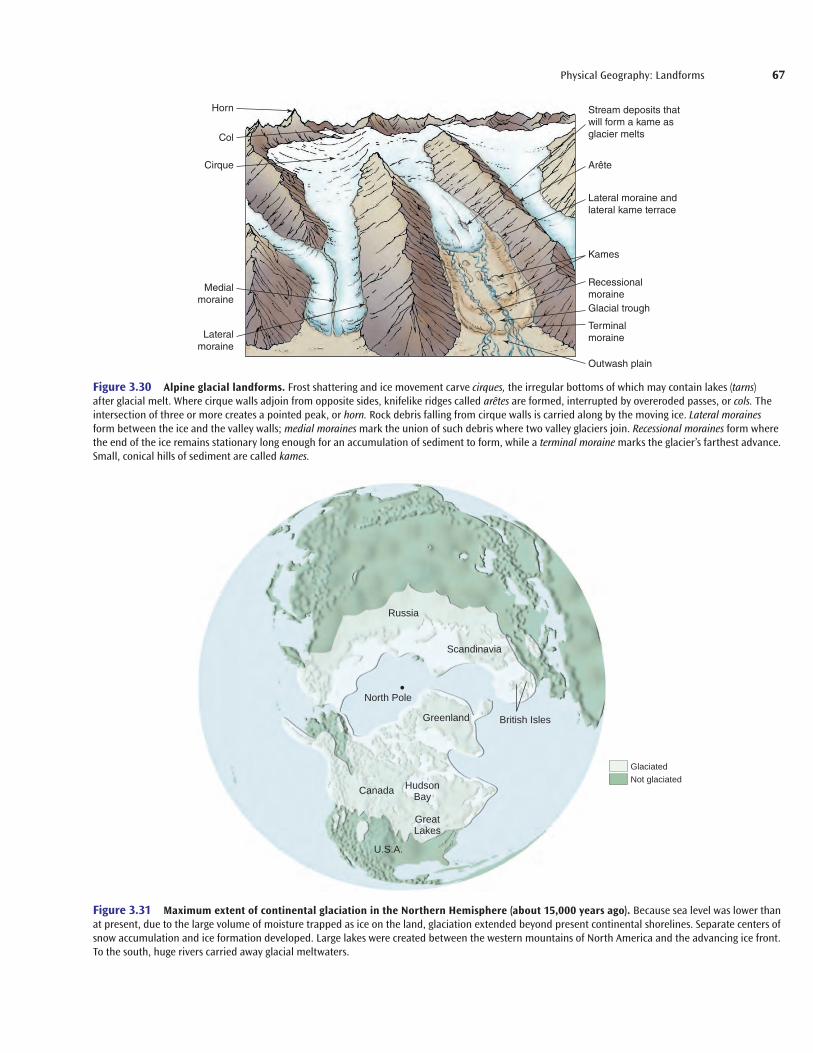
Small particles, such as clay and silt, are suspended in water and constitute—together with material dissolved in the water or dragged along the bottom—the load of a stream. Rapidly mov-ing floodwaters carry huge loads. As high water or floodwater recedes, and stream velocity decreases, sediment contained within the stream no longer remains suspended, and particles begin to settle. Heavy, coarse materials drop the quickest; finer particles are carried longer and transported farther. The decline in veloc-ity and the resulting deposition are especially pronounced and abrupt when streams meet slowly moving water in bays, oceans, and lakes. Silt and sand accumulate at the intersections, creating deltas, as pictured in Figure 3.23.
A great river, such as the Chang Jiang (Yangtze) in China, has a large, growing delta, but less prominent deltas exist at the mouths of many streams. Until the recent completion of the Aswan Dam, the huge delta of the Nile River had been growing. Now much of the silt is being dropped in Lake Nasser behind the dam, which is far upstream from the delta.
(b)(a)
get22880_ch03_045-073.indd 62get22880_ch03_045-073.indd 62 9/3/13 6:47 PM9/3/13 6:47 PM
Final PDF to printer
TIBET PLATEAU
Himalayas
Erosion of rocks in
Himalayas
Brahmaputra River
Ganges River
Brown river indicatestransport of sediment
Delta
Bay of Bengal
BANGLADESH
INDIA
Physical Geography: Landforms 63
valleys that are wider than those in mountainous areas. Surrounding hills become rounded, and valleys eventually become floodplainsas they broaden and flatten. Streams work to widen the floodplain. Their courses meander, constantly carving out new river channels. The channels left behind as new ones are cut become oxbow lakes, hundreds of which are found in the Mississippi River floodplain. An oxbow lake is crescent-shaped and occupies the abandoned channel of a stream meander (Figure 3.24b).
In nearly flat floodplains, the highest elevations may be the banks of rivers, where natural levees are formed by the deposition of silt at river edges during floods. Floods that breach levees are par-ticularly disastrous because floodwaters fill the floodplain as they equalize its elevation with that of the swollen river. The U.S. Army Corps of Engineers has augmented the natural levees in particu-larly susceptible areas, such as the banks of the lower Mississippi River, but some of these barriers failed during Hurricane Katrina in August 2005 (Figure 3.25).
Stream Landscapes in Arid Areas A distinction must be made between the results of stream erosion in humid regions and those in arid areas. The lack of vegetation in arid regions greatly increases the erosional force of running water. Water originating in moun-tainous areas sometimes never reaches the sea if the channel runs through a desert. In fact, stream channels may be empty except during rainy periods, when water rushes down hillsides to collect and form temporary lakes called playas. In the process, alluvium(sand and mud) builds up in the lakes and at lower elevations, and alluvial fans are formed along hillsides (Figure 3.26). The fan is produced by the deposition of silt, sand, and gravel outward as the stream reaches lowlands at the base of the slope it traverses. If the process has been particularly long-standing, alluvial deposits may bury the eroded mountain masses. In desert regions in Nevada, Arizona, and California, it is not unusual to observe partially bur-ied mountains poking through eroded material.
Figure 3.23 The Ganges and Brahmaputra Rivers are fed by the streams from the Himalayas. Note the brown sediment entering the Bay of Bengal. NASA.
Figure 3.22 Gullying can result from heavy rain and poor farming techniques, including overgrazing by livestock or many years of continuous row crops. Surface runoff removes topsoil easily when vegetation is too thin to protect it. USDA-Natural Resources Conservation Service.
In plains adjacent to streams, land is sometimes built up by the deposition of stream load. If the deposited material is rich, it may be a welcome and necessary part of farming activities, such as that historically known in Egypt along the Nile. Should the deposition be composed of sterile sands and boulders, however, formerly fer-tile bottomland may be destroyed. By drowning crops or inundating inhabited areas, the floods themselves, of course, may cause great human and financial loss. More than 900,000 lives were lost in the floods of the Huang He (Yellow River) of China in 1887.
Stream LandscapesA landscape is in a particular state of balance between the uplift of land and its erosion. Rapid uplift is not followed by nicely ordered stages of erosion. Recall that uplift and erosion take place simul-taneously. At a given location, one force may be greater than the other at a given time, but as yet there is no way to predict accu-rately the “next” stage of landscape evolution.
Perhaps the most important factor differentiating the effect of streams on landforms is whether the recent climate (for example, the past several million years) has tended to be humid or arid.
Stream Landscapes in Humid Areas Perhaps weak surface material or a depression in rock allows the development of a stream channel. In its downhill run in mountainous regions, a stream may fl ow over precipices, forming falls in the process. The steep downhill gradient allows streams to fl ow rapidly, cutting narrow, V-shaped channels in the rock (Figure 3.24a). Under these conditions, the erosional process is greatly accelerated. Over time, the stream may have worn away suffi cient rock for the falls to become rapids, and the stream channel becomes incised below the height of the surrounding land-forms. This is evident in the upper reaches of the Delaware, Con-necticut, and Tennessee rivers.
In humid areas, the effect of stream erosion is to round land-forms. Streams flowing down moderate gradients tend to carve
get22880_ch03_045-073.indd 63get22880_ch03_045-073.indd 63 9/3/13 9:18 PM9/3/13 9:18 PM
Final PDF to printer

64 Chapter 3
Figure 3.24 (a) V-shaped valley of a rapidly downcutting stream, the Yellowstone River in Wyoming. (b) An oxbow-shaped lake adjoining a meandering stream in Wyoming. (a) © Robert N. Wallen; (b) U.S. Geological Survey.
Figure 3.25 Aerial view of damage caused by Hurricane Katrina the day after the hurricane hit, August 30, 2005. FEMA—Federal Emergency Management Agency.
Because streams in arid areas have only a temporary exis-tence, their erosional power is less consistent than that of the freely flowing streams of humid areas. In some instances, they barely mark the landscape; in other cases, swiftly moving water may carve deep, straight-sided arroyos. Water may rush onto an allu-vial plain in a complicated pattern resembling a multistrand braid, leaving in its wake an alluvial fan. The channels resulting from this rush of water are called washes. The erosional power of unre-stricted running water in arid regions is dramatically illustrated by the steep-walled configuration of buttes and mesas (large buttes), such as those in Utah shown in Figure 3.27.
(b)
(a)
Narrow mountain canyon
Plain
Alluvial fanBraidedstream
Figure 3.26 Alluvial fans are built where the velocity of streams is reduced as they flow out upon the more level land at the base of the mountain slope. The abrupt change in slope and velocity greatly reduces the stream’s capacity to carry its load of coarse material. Deposition occurs, choking the stream channel and diverting the flow of water. With the canyon mouth fixing the head of the alluvial fan, the stream sweeps back and forth, building and extending a broad area of deposition. Redrawn from Charles C. Plummer and David McGeary, Physical Geology, 8th ed.
get22880_ch03_045-073.indd 64get22880_ch03_045-073.indd 64 9/3/13 6:47 PM9/3/13 6:47 PM
Final PDF to printer

Unsaturatedzone
Saturated rockWater table
Lake Stream
Physical Geography: Landforms 65
GroundwaterSome of the water supplied by rain and snow sinks underground into pores and cracks in rocks and soil, not in the form of an under-ground pond or lake but simply as subsurface material. When underground water accumulates, a zone of saturation called an aquifer forms, through which water can move readily. As indicated in Figure 3.28, the upper level of this zone is the water table;below it, the soils and rocks are saturated with water. A well may be drilled into an aquifer to ensure a supply of water. Groundwater moves constantly but very slowly (usually only centimeters a day). Most remains underground, seeking the lowest level. When the sur-face of the land dips below the water table, however, ponds, lakes, and marshes form. Some water fi nds its way to the surface by capil-lary action in the ground or in vegetation. When the ground surface extends below the level of the water table, the most common feature to develop is a stream.
Groundwater, particularly when combined with carbon diox-ide, dissolves soluble materials by a chemical process called solu-tion. Although groundwater tends to decompose many types of rocks, its effect on limestone is most spectacular. Many of the great caves of the world have been created by the underground movement of water through limestone regions. Water sinking through the over-lying rock leaves carbonate deposits as it drips into empty spaces. The deposits hang from cave roofs (stalactites) and build upward from cave floors (stalagmites). In some areas, the uneven effect of groundwater erosion on limestone leaves a landscape pockmarked by a series of sinkholes, surface depressions in an area of collapsing caverns.
Karst topography refers to a large limestone region marked by sinkholes, caverns, and underground streams, as shown in Figure 3.29. East central Florida, a karst area, has suffered con-siderable damage from the creation and widening of sinkholes.
This type of topography gets its name from a region on the Adri-atic Sea at the Italy-Slovenia border. The Mammoth Cave region of Kentucky, another karst area, has many kilometers of intercon-nected limestone caves.
GlaciersAnother agent causing erosion and deposition to occur is glaciers. Although they are much less extensive today, glaciers covered a large part of the earth’s land area as recently as 10,000 to 15,000 years ago. Many landforms were created by the erosional or depo-sitional effects of glaciers.
Glaciers form only in very cold places with short or nonex-istent summers, where annual snowfall exceeds annual snowmelt and evaporation. The weight of the snow causes it to compact at the base and form ice. When the snowfall reaches a thickness of about 100 meters (328 ft), ice at the bottom becomes like thick toothpaste and begins to move slowly. A glacier, then, is a large body of ice moving slowly down a slope or spreading outward on a land sur-face (Figure 3.30). Some glaciers appear to be stationary simply because the melting and evaporation at the glacier’s edge equal the speed of the ice advance. Glaciers can, however, move as much as a meter per day.
Most theories of glacial formation concern earth climatic cooling. Perhaps a combination of the following theories explains the evolution of glaciers. The first theory attributes cooling to peri-ods when there may have been excessive amounts of volcanic dust in the atmosphere. The argument is that the dust, by reducing the amount of solar energy reaching the earth, effectively lowered tem-peratures at the surface. A second theory attributes the ice ages to known changes in the shape, tilt, and seasonal positions of the earth’s orbit around the sun over the last half-million years. Such changes alter the amount of solar radiation received by the earth and its distribution over the earth. A recent theory suggests that, when large continental plates drift over polar regions, temperatures on Earth become more extreme and, as a result, induce the devel-opment of glaciers. This theory, of course, cannot explain the most recent ice ages.
Today, continental-size glaciers exist on Antarctica, Greenland, and Baffin Island in Canada, but mountain glaciers
Figure 3.27 Canyonlands National Park, Utah. The resistant caprock of the mesa protects softer, underlying strata from downward erosion. Where the caprock is removed, lateral erosion lowers the surface, leaving the mesa as an extensive and pronounced relic of the former higher-lying landscape. © Corbis RF.
Figure 3.28 The groundwater table generally follows surface contours but in subdued fashion. Water flows slowly through the saturated rock, emerging at earth depressions that are lower than the level of the water table. During a drought, the table is lowered and the stream channel becomes dry.
get22880_ch03_045-073.indd 65get22880_ch03_045-073.indd 65 9/3/13 6:47 PM9/3/13 6:47 PM
Final PDF to printer

66 Chapter 3
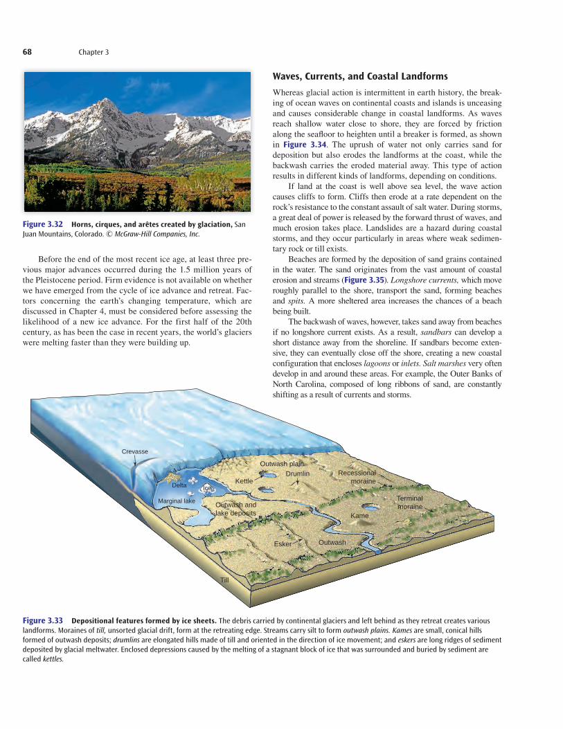
after the glacier has receded. If the valley is below sea level today, as in Norway or British Columbia, fiords, or arms of the sea, are formed. Some of the landforms created by scouring are shown in Figure 3.30. Figure 3.32 shows horns, cirques, and arêtes, sharp ridges that separate adjacent glacially carved valleys. Cirques are formed by ice erosion at the head of a glacial valley.
Glaciers create landforms when they deposit the debris they have transported. These deposits, called till, consist of rocks, pebbles, and silt. As the great tongues of ice move forward, debris accumulates in parts of the glacier. The ice that scours valley walls and the ice at the tip of the advancing tongue are particularly filled with debris. As a glacier melts, it leaves behind hills of till of dif-ferent sizes and shapes, such as moraines, eskers, and drumlins (Figure 3.33).
Many other landforms have been formed by glaciers. The most important is the outwash plain, a gently sloping area in front of a melting glacier. The melting along a broad front sends thousands of small streams running out from the glacier in braided fashion, streams that deposit neatly stratified drift made up of sand and gravel. Outwash plains, which are essentially great alluvial fans, cover a wide area and provide new parent-material for soil formation. Most of the midwestern part of the United States owes some of its soil fertility to the effects of wind on glacial deposition (see Figure 3.38).
are found in many parts of the world. About 10% of the earth’s land area is under ice. During the most recent advance of ice, the continental ice of Greenland was part of an enormous glacier that covered nearly all of Canada (Figure 3.31) and the northern-most portions of the United States and Eurasia. The giant gla-cier reached thicknesses of 3000 meters (10,000 ft) (the depth in Greenland today), enveloping entire mountain systems. Another feature of the last ice age was the development of permafrost, a permanently frozen layer of ground that can be as much as 1500 meters (4900 ft) deep. Because the permafrost layer pre-vents the downward percolation of moisture, the surface soil may become saturated with water during the brief summer season, when only a thin surface thaws. In recent years, glaciers have been melting at a faster rate than their development due to a decided warming of the far northern and southern latitudes. Cli-mate change is discussed in Chapter 4.
The weight of glaciers breaks up underlying rock and pre-pares it for transportation by the moving mass of ice. Conse-quently, glaciers change landforms by erosion. Glaciers scour the land as they move, leaving surface scratches, or striations, on rocks that remain. Much of eastern Canada has been scoured by glaciers that left little soil but many ice-gouged lakes and streams. The erosional forms created by glacial scourings have a variety of names. A glacial trough is a deep, U-shaped valley visible only
Sinkhole
Cavern
(a)
Sinkhole
PondCollapsed cavern
and underground stream
(b)
Figure 3.29 Limestone erodes easily in the presence of water. (a) Karst topography, such as that shown here, occurs in humid areas where limestone in flat beds is at the surface. (b) This satellite photo of east central Florida shows the many round lakes formed in the sinkholes of a karst landscape. (b) NASA.
get22880_ch03_045-073.indd 66get22880_ch03_045-073.indd 66 9/3/13 6:47 PM9/3/13 6:47 PM
Final PDF to printer
Horn
Col
Cirque
Medialmoraine
Lateralmoraine
Recessionalmoraine
Outwash plain
Terminalmoraine
Glacial trough
Stream deposits thatwill form a kame asglacier melts
Kames
Lateral moraine andlateral kame terrace
Arête
Physical Geography: Landforms 67
Figure 3.30 Alpine glacial landforms. Frost shattering and ice movement carve cirques, the irregular bottoms of which may contain lakes (tarns) after glacial melt. Where cirque walls adjoin from opposite sides, knifelike ridges called arêtes are formed, interrupted by overeroded passes, or cols. The intersection of three or more creates a pointed peak, or horn. Rock debris falling from cirque walls is carried along by the moving ice. Lateral moraines form between the ice and the valley walls; medial moraines mark the union of such debris where two valley glaciers join. Recessional moraines form where the end of the ice remains stationary long enough for an accumulation of sediment to form, while a terminal moraine marks the glacier’s farthest advance. Small, conical hills of sediment are called kames.
North Pole
Greenland
Canada
U.S.A.
Russia
Scandinavia
British Isles
HudsonBay
GreatLakes
GlaciatedNot glaciated
Figure 3.31 Maximum extent of continental glaciation in the Northern Hemisphere (about 15,000 years ago). Because sea level was lower than at present, due to the large volume of moisture trapped as ice on the land, glaciation extended beyond present continental shorelines. Separate centers of snow accumulation and ice formation developed. Large lakes were created between the western mountains of North America and the advancing ice front. To the south, huge rivers carried away glacial meltwaters.
get22880_ch03_045-073.indd 67get22880_ch03_045-073.indd 67 9/3/13 6:47 PM9/3/13 6:47 PM
Final PDF to printer
68 Chapter 3
Waves, Currents, and Coastal LandformsWhereas glacial action is intermittent in earth history, the break-ing of ocean waves on continental coasts and islands is unceasing and causes considerable change in coastal landforms. As waves reach shallow water close to shore, they are forced by friction along the seafl oor to heighten until a breaker is formed, as shown in Figure 3.34. The uprush of water not only carries sand for deposition but also erodes the landforms at the coast, while the backwash carries the eroded material away. This type of action results in different kinds of landforms, depending on conditions.
If land at the coast is well above sea level, the wave action causes cliffs to form. Cliffs then erode at a rate dependent on the rock’s resistance to the constant assault of salt water. During storms, a great deal of power is released by the forward thrust of waves, and much erosion takes place. Landslides are a hazard during coastal storms, and they occur particularly in areas where weak sedimen-tary rock or till exists.
Beaches are formed by the deposition of sand grains contained in the water. The sand originates from the vast amount of coastal erosion and streams (Figure 3.35). Longshore currents, which move roughly parallel to the shore, transport the sand, forming beaches and spits. A more sheltered area increases the chances of a beach being built.
The backwash of waves, however, takes sand away from beaches if no longshore current exists. As a result, sandbars can develop a short distance away from the shoreline. If sandbars become exten-sive, they can eventually close off the shore, creating a new coastal configuration that encloses lagoons or inlets. Salt marshes very often develop in and around these areas. For example, the Outer Banks of North Carolina, composed of long ribbons of sand, are constantly shifting as a result of currents and storms.
Before the end of the most recent ice age, at least three pre-vious major advances occurred during the 1.5 million years of the Pleistocene period. Firm evidence is not available on whether we have emerged from the cycle of ice advance and retreat. Fac-tors concerning the earth’s changing temperature, which are discussed in Chapter 4, must be considered before assessing the likelihood of a new ice advance. For the first half of the 20th century, as has been the case in recent years, the world’s glaciers were melting faster than they were building up.
Figure 3.32 Horns, cirques, and arêtes created by glaciation, San Juan Mountains, Colorado. © McGraw-Hill Companies, Inc.
Crevasse
Marginal lake
IceDelta
Drumlin
Kame
Kettle
Esker
Outwash andlake deposits
Terminalmoraine
Recessionalmoraine
Outwash plain
Outwash
Till
Figure 3.33 Depositional features formed by ice sheets. The debris carried by continental glaciers and left behind as they retreat creates various landforms. Moraines of till, unsorted glacial drift, form at the retreating edge. Streams carry silt to form outwash plains. Kames are small, conical hills formed of outwash deposits; drumlins are elongated hills made of till and oriented in the direction of ice movement; and eskers are long ridges of sediment deposited by glacial meltwater. Enclosed depressions caused by the melting of a stagnant block of ice that was surrounded and buried by sediment are called kettles.
get22880_ch03_045-073.indd 68get22880_ch03_045-073.indd 68 9/3/13 6:47 PM9/3/13 6:47 PM
Final PDF to printer

Breakers Wave movement
Shallowing wateras land is approached
(a)
Bottom
Physical Geography: Landforms 69
may make it unusable for agriculture. Inhabitants of Oklahoma, Texas, and Colorado suffered greatly in the 1930s when their farm-lands became the “Dust Bowl” of the United States.
Several types of landforms are produced by wind-driven sand. Figure 3.37 depicts one of these. Although sandy deserts are much less common than gravelly deserts, also called desert pave-ment, their characteristic landforms are better known. Most of the Sahara, the Gobi, and the western U.S. deserts are covered with rocks, pebbles, and gravel, not sand. Each also has a small portion (and the Saudi Arabian Desert has a large area) covered with sand blown by wind into a series of waves, or dunes. Unless vegetation stabilizes them, the dunes move as sand is blown from their wind-ward faces onto and over their crests. One of the most distinctive sand desert dunes is the crescent-shaped barchan. Along sea-coasts and inland lakeshores, in both wet and dry climates, wind can create sand ridges that reach a height of 90 meters (300 ft). Sometimes, coastal communities and farmlands are threatened or destroyed by moving sand (see “Beaches on the Brink” p. 71).
Another kind of wind-deposited material, silty in texture, is called loess. Encountered usually in midlatitude westerly wind
Coral reefs, made not from sand but from coral organisms growing in shallow tropical water, are formed by the secretion of calcium carbonate in the presence of warm water and sunlight. Reefs, consisting of millions of colorful coral skeletons, develop short distances offshore. Off the coast of northeastern Australia lies the most famous coral reef, the Great Barrier Reef. Atolls, found in the South Pacific, are reefs formed in shallow water around a volcano that has since been covered or nearly covered by water (Figure 3.36).
WindIn humid areas, vegetation cover confi nes the effect of wind mainly to sandy beach areas, but in dry climates, wind is a powerful agent of erosion and deposition. Limited vegetation in dry areas leaves exposed particles of sand, clay, and silt subject to movement by wind. Thus, many of the sculptured features found in dry areas result from mechanical weathering, that is, from the abrasive action of sand and dust particles as they are blown against rock surfaces. Sand and dust storms occurring in a drought-stricken farm area
Figure 3.34 Formation of waves and breakers. (a) As the offshore swell approaches the gently sloping beach bottom, sharp-crested waves form, build up to a steep wall of water, and break forward in plunging surf. (b) Evenly spaced breakers form as successive waves touch bottom along a regularly sloping shore. (b) © Carla Montgomery.
River
Cliff erosion
Beach
Longshore currentOffshore sandbar
Spit
Figure 3.35 The cliffs behind the shore are eroded by waves during storms and high water. Sediment from the cliff and river forms the beach deposit; the longshore current moves some sediment downcurrent to form a spit. Offshore sandbars are created from material removed from the beach and deposited by retreating waves. Generally, not all the features shown here would occur in a single setting.
(b)
get22880_ch03_045-073.indd 69get22880_ch03_045-073.indd 69 9/3/13 6:48 PM9/3/13 6:48 PM
Final PDF to printer

70 Chapter 3
major deposits are assumed to have resulted from wind erosion of nonvegetated sediment deposited by meltwater from retreating glaciers. Because rich soils usually form from loess deposits, if climatic circumstances are appropriate, these areas are among the most productive agricultural lands in the world.
3.6 Landform RegionsEvery piece of land not covered by buildings and other structures contains clues as to how it has changed over time. Geomorpholo-gists interpret these clues, studying such things as earth materials and soils, the availability of water, drainage patterns, evidences of erosion, and glacial history. The scale of analysis may be as small as a stream or as large as a landform region, a large section of the earth’s surface where a great deal of homogeneity occurs among the types of landforms that characterize it.
A foldout map inside the back cover of this book shows, in a general way, the kinds of landform regions found in different parts of the world. Note how the mountain belts generally coincide with convergent plate boundaries not found beneath the sea (see Figure 3.6) and with the earthquake-prone areas (see Figure 3.8). Vast plains exist in North and South America, Europe, Asia, and Australia. Many of these regions were created under former seas and appeared as land when seas contracted. These, and the smaller plains areas, are the drainage basins for some of the great
belts, it covers extensive areas in the United States (Figure 3.38), central Europe, central Asia, and Argentina. It has its greatest development in northern China, where loess covers hundreds of thousands of square miles, often to depths of more than 30 meters (100 ft). The windborne origin of loess is confirmed by its typi-cal occurrence downwind from extensive desert areas, though
Figure 3.36 Coral reef, part of the Great Barrier Reef off the east coast of Australia. Corbis Royalty Free.
Figure 3.37 The prevailing wind from the left has given these transverse dunes a characteristic gentle windward slope and a steep, irregular leeward slope. Courtesy of James A. Bier.
get22880_ch03_045-073.indd 70get22880_ch03_045-073.indd 70 9/3/13 6:48 PM9/3/13 6:48 PM
Final PDF to printer
71
Beaches on the BrinkHeadlines such as “Beaches on the Brink,” “Storm-Lashed Cape Is a Fragile Environment,” “Fighting the Development Tide,” and “State Looks for Money to Restore the Shore” signal a growing concern with the condition of coastlines. In addition, they raise the central question of how we can utilize coastlines without, at the same time, destroying them. Hurricane Sandy played havoc with beachfront property in densely settled New York and New Jersey.
Because many of the world’s people live or vacation on coasts, and because such areas are often densely populated, coastal processes have a considerable impact on humans. Nature’s forces are continually shaping and reshaping the coasts; they are dynamic environments, always in a state of fl ux. Some processes are dramatic and induce rapid change: trop-ical cyclones (hurricanes and typhoons), tsunami, and fl oods can wreak havoc, take thousands of lives, and cause millions of dollars in damage in a matter of hours. A less hazardous process is beach erosion, although it tends to magnify the effects of storms.
Some beach erosion is caused by natural processes, both marine and land. Waves carry huge loads of suspended sand, and longshore currents constantly move sand along the shoreline. The weathering and erosion of sea cliffs produces sediment, and rivers carry silt from mountains to beaches.
Human activities affect both erosion and deposition, however. Dams, for example, decrease the fl ow of sand to the water’s edge by trapping sediment upstream. We fi ll marshes, construct dikes, and bulldoze dunes or remove their natural stabilizing vegetation. We hasten erosion when we build roads, houses, and other structures on cliffs and dunes or when we plant trees and lawns on top of them.
Especially vulnerable to erosion are barrier islands, narrow strips of sand parallel to the mainland. Under natural conditions, they are not stable places; their ends typically migrate, and during storms, waves can wash right over them. Some barrier islands are highly developed and densely populated, including Atlantic City and Miami Beach.
Once hotels and condominiums, railroads, and highways have been built along the waterfront, people attempt to protect their investments by preventing beaches from eroding. Breakwaters, offshore structures built to absorb the force of large, breaking waves and to provide quiet water near shore, are designed to trap sand and thus retard erosion, but they are not always successful. Although some are locally benefi cial by forming new areas of deposition, they almost invariably accelerate erosion in adjacent areas. The efforts of one community are often negated by those of nearby towns and cities, underscoring the need for agencies to coordinate efforts and develop comprehensive land use plans for an extensive length of shoreline.
An alternative to erecting artifi cial structures is beach replenishment: adding sand to beaches to replace that lost by erosion. This provides recreational opportunities; at the same time, it buffers property from damage by storms. Sand may be dredged from harbors or pumped from offshore sandbars. The disadvantages of this technique are that dredg-ing disrupts marine organisms, sand of the right texture may be hard to obtain, and replenished beaches can be short-lived. For example, more than $5 million was spent replenishing the beach at Ocean City, New Jersey, in 1982. The beach disappeared within 3 months, after a series of northeasters hit the area. Similarly, a massive dredging project that cost more than $17 million replenished 8 kilometers (5 mi) of beaches along the San Diego coast in 2000. Within months, after the largest waves of the year pounded the coast, more than one-half of the sand was gone.
The expense of maintaining coastal zones raises two basic ques-tions: Who benefi ts? Who should pay? Some people contend that the interests of those who own coastal property are not compatible with the public interest, and it is unwise to expend large amounts of public funds
to protect the property of only a few. People argue that shorefront busi-nesses and homeowners are the chief benefi ciaries of shore protection measures, that they often deny the public access to the beaches in front of their property, and therefore they should pay for the majority of the cost of maintaining the shoreline. At present, however, this is rarely the case; costs are typically shared by communities, states, and the federal gov-ernment. Indeed, 51 federal programs subsidize coastal development and redevelopment. The largest is the National Flood Insurance Program, which offers low-cost insurance to homeowners in fl ood-prone areas. People have used the protection of that insurance to build anywhere, even in high-risk coastal areas.
Considering the Issues 1. From 1994 to the present, the Army Corps of Engineers has spent
millions of dollars annually to pump sand from the ocean bottom onto eroded beaches in New Jersey. This ongoing project is based on the assumption that additional replenishment will be required
PUBLIC POLICYGEOGRAPHY
&
Storm surge damage on North Carolina’s Outer Banks (a) before and (b) after Hurricane Fran in 1996. U.S. Geological Survey Center for Coastal Geology.
(continued)
(b)
(a)
get22880_ch03_045-073.indd 71get22880_ch03_045-073.indd 71 9/3/13 6:48 PM9/3/13 6:48 PM
Final PDF to printer

72 Chapter 3
Humans affect and are affected by the landscape, landforms, moving continents, and earthquakes; however, except at times of natural disaster, these elements of the physical world are, for most of us, quiet, accepted background. More immediate in affecting our lives and fortunes are the great patterns of climate. Climate helps define the limits of the economically possible with present levels of technology, the daily changes of weather that affect the success of picnics and crop yield alike, and the patterns of vegetation and soils. We turn our attention to these elements of the natural environment in Chapter 4.
rivers of the world, such as the Mississippi- Missouri, Amazon, Volga, Nile, Ganges, and Tigris-Euphrates. The valleys carved by these rivers and the silt deposited by them are among the most agriculturally productive areas in the world. The plateau regions are many and varied. The African plateau region is the largest. Much of the African landscape is characterized by low mountains and hills whose base is about 700 meters (2300 ft) above sea level. Generally quiet from the standpoint of tectonic activity, Africa is largely made up of geologically ancient continental blocks that have been in an advanced stage of erosion for millions of years.
every 5 or 6 years as beaches erode. Currently, the federal gov-ernment pays 65% of the cost, the state government 25%, and local governments 10%. New Jersey Senator Frank Lautenberg contends that beach replenishment is critical for the region’s future. “People’s lives and property are at stake. Jersey’s beaches bring crucial tourist dollars to the state.” But James Tripp of the Environmental Defense Fund argues that beach rebuilding is sim-ply throwing taxpayers’ money into the ocean. “Pumping all the sand in the world is not going to save the day.” Do you think the beach replenishment project is a wise use of taxpayers’ money? Does the federal government have an obligation to protect or rebuild storm-damaged beaches? Why or why not?
2. Coastal erosion is not a problem for beaches, only for people who want to use them. Do you believe that we should learn to live with erosion, not building in the coastal zone unless we are prepared to
consider our structures temporary and expendable? Should com-munities adopt zoning plans that prohibit building on undeveloped lands within, say, 50 meters (164 ft) of the shore?
3. Should the federal government curtail programs that provide inex-pensive storm insurance for oceanfront houses and businesses, as well as speedy grants and loans for storm repairs not covered by insurance? Should people be allowed to rebuild storm-damaged buildings even if they are vulnerable to future damage? Why or why not?
4. Coastal erosion will become more serious if the current rise in sea level—about 2.5 centimeters (1 in.) every 12 years—continues or even increases as global warming causes seawater to expand or the polar ice caps to melt. Many of the world’s major cities would be threatened by this rise in sea level. What are some of those cities? How might they protect themselves?
More than 7.51.5–7.5Less than 1.5
Deposit Thickness in Meters
Figure 3.38 Location of windblown silt deposits, including loess, in the United States. The thicker layers, found in the upper Mississippi Valley area, are associated with the wind movement of glacial debris. Farther west, in the Great Plains, wind-deposited materials are sandy in texture, not loessial. Adapted from Geology of Soils by Charles B. Hunt, copyright 1972 W. H. Freeman and Company.
(continued)
get22880_ch03_045-073.indd 72get22880_ch03_045-073.indd 72 9/3/13 6:48 PM9/3/13 6:48 PM
Final PDF to printer
Physical Geography: Landforms 73
alluvium 63asthenosphere 48 chemical weathering 58 continental drift 48 diastrophism 52erosional agents 59faults 50floodplain 63fold 52glacier 65
gradational processes 56igneous rock 46karst topography 65lithosphere 48loess 69mass movement 59mechanical weathering 57metamorphic rock 47mineral 46permafrost 66
Key Words
Thinking Geographically 1. How can rocks be classified? List three classes of rocks according
to their origin. In what ways can they be distinguished from one another?
2. What evidence makes the theory of plate tectonics plausible?
3. What is subduction? What are its effects?
4. Explain what is meant by gradation and volcanism.
5. What is meant by folding, joint, and faulting?
6. Draw a diagram indicating the varieties of ways faults occur.
7. With what earth movements are earthquakes associated? What are tsunami and how do they develop?
8. What is the distinction between mechanical and chemical weather-ing? Is weathering responsible for landform creation? In what ways do glaciers engage in mechanical weathering?
9. Explain the origin of the various landforms one usually finds in desert environments.
10. How do glaciers form? What landscape characteristics are associ-ated with glacial erosion? With glacial deposition?
11. How are alluvial fans, deltas, natural levees, and moraines formed?
12. How is groundwater erosion differentiated from surface water erosion?
13. How are the processes that bring about change due to waves and currents related to the processes that bring about change by the force of wind?
14. What processes account for the landform features of the area in which you live?
Summary of Key Concepts • Rocks, the materials that constitute the earth’s surface, are clas-
sifi ed as igneous, sedimentary, and metamorphic.
• In the most recent 200 million of the earth’s 4.5 billion years, continental plates drifted on the asthenosphere to their present positions.
• At or near plate intersections, tectonic activity is particularly in evidence in two forms. Diastrophism, such as faulting, results in earthquakes and, on occasion, tsunami. Volcanism moves molten materials toward the earth’s surface.
• The building up of the earth’s surface is balanced by three gra-dational processes—weathering, mass movement, and erosion. Weathering, both mechanical and chemical, prepares materials for transport by disintegrating rocks and is instrumental in the development of soils. Talus slopes and soil-creep are examples of the effect of mass movement. The erosional agents of running water, groundwater, glaciers, waves and currents, and wind move materials to new locations.
• Examples of landforms created by the collection of eroded mate-rials are alluvial fans, deltas, natural levees, moraines, and sand dunes.
plate tectonics 48sedimentary rock 47subduction 52tsunami 54
volcanism 52warping 52water table 65weathering 57
get22880_ch03_045-073.indd 73get22880_ch03_045-073.indd 73 9/3/13 6:48 PM9/3/13 6:48 PM
Final PDF to printer