GEOTECHNICAL RE PORT
110
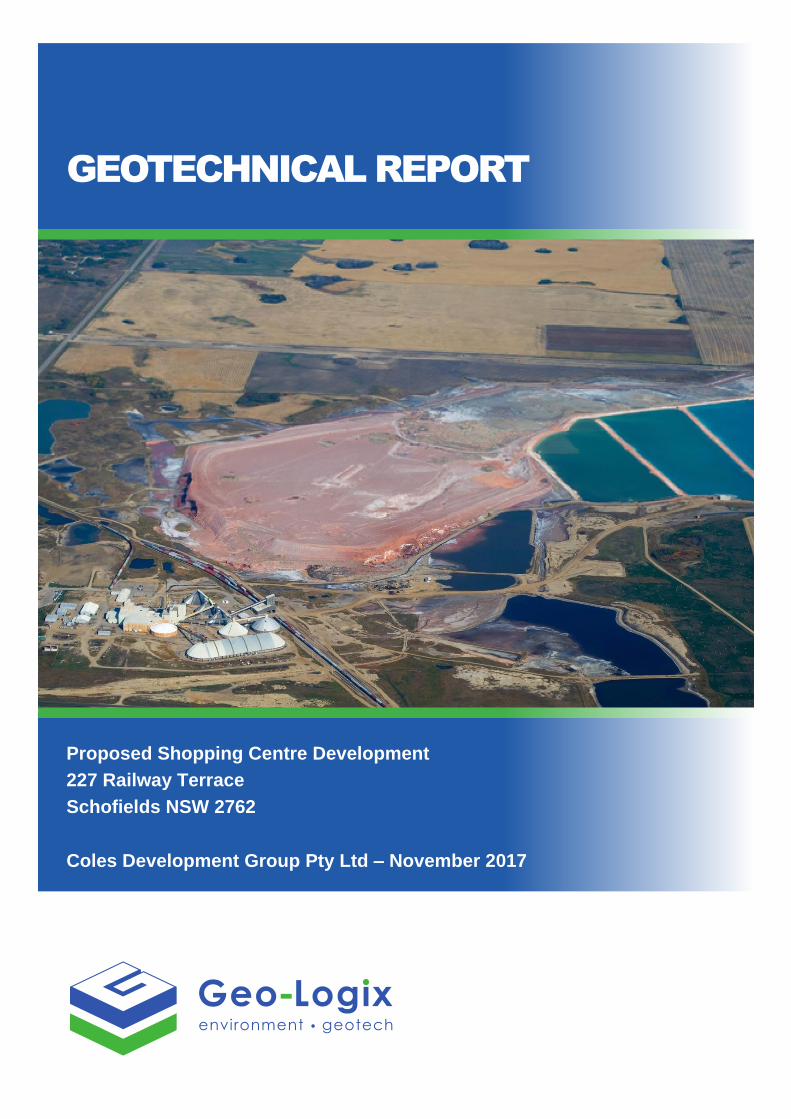
GEOTECHNICAL REPORT Proposed Shopping Centre Development 227 Railway Terrace Schofields NSW 2762 Coles Development Group Pty Ltd – November 2017
Transcript of GEOTECHNICAL RE PORT
GEOTECHNICAL REPORT
Proposed Shopping Centre Development
227 Railway Terrace
Schofields NSW 2762
Coles Development Group Pty Ltd – November 2017

Geotechnical Report 1701104Rpt02FinalV01_20Nov17 ● Page i
DOCUMENT CONTROL
GEOTECHNICAL REPORT
Proposed Shopping Centre Development
227 Railway Terrace
Schofields NSW 2762
PREPARED FOR
Coles Property Development Group Pty Ltd
6 Giffnock Avenue
Macquarie Park, NSW 2113
Report reference: 1701104Rpt02FinalV01_20Nov17
Date: 20th November 2017
DISTRIBUTION AND REVISION REGISTER
Revision
Number Date Description Recipient Deliverables
V01 20/11/2017 Final Report
1701104Rpt02FinalV01_20Nov17 Geo-Logix Pty Ltd 1 Electronic Copy
V01 20/11/2017 Final Report
1701104Rpt02FinalV01_20Nov17 Coles Group Ltd 1 Electronic Copy
Issued by: Geo-Logix Pty Ltd
ABN: 86 116 892 936
______________________ _________________________
Edward Lilly Ben Pearce
BS Civil Engineering, MIEAust BSc (Hons), MEIANZ CEnvP#321
Senior Geotechnical Engineer Principal

Geotechnical Report 1701104Rpt02FinalV01_20Nov17 ● Page ii
TABLE OF CONTENTS
1. INTRODUCTION ................................................................................................................. 2
1.1 Proposed Development ............................................................................................... 2
1.2 Objectives and Scope of Work .................................................................................... 2
2. SITE INFORMATION ........................................................................................................... 3
2.1 Site Identification and Description ............................................................................. 3
2.2 Topography ................................................................................................................... 4
2.3 Regional Geology ......................................................................................................... 4
2.4 Regional Hydrology ..................................................................................................... 4
3. METHOD OF INVESTIGATION .......................................................................................... 4
3.1 Investigation Methods ................................................................................................. 4
4. PREVIOUS GEOTECHNICAL REPORT ............................................................................. 5
4.1 Douglas Partners (2011) .............................................................................................. 5
5. INVESTIGATION RESULTS ............................................................................................... 5
5.1 Surface and Subsurface Conditions .......................................................................... 5
5.2 Groundwater ................................................................................................................. 6
5.3 Laboratory Results ....................................................................................................... 6
5.4 USCS Classification Testing ....................................................................................... 6
5.5 Shrink Swell Index (SSI) .............................................................................................. 7
5.6 Californian Bearing Ratio ............................................................................................ 7
5.7 Exposure Classification Tests .................................................................................... 8
5.8 Uniaxial Compressive Strength Test .......................................................................... 8
5.9 Point Load Strength Index Tests ................................................................................ 9
6. DISCUSSION ..................................................................................................................... 10
6.1 Earthworks .................................................................................................................. 10
6.2 Excavations ................................................................................................................ 11
6.3 Groundwater Inflow .................................................................................................... 11
6.4 Temporary and Permanent Batter Slopes ................................................................ 12
6.5 Retaining Walls and Shoring ..................................................................................... 12

Geotechnical Report 1701104Rpt02FinalV01_20Nov17 ● Page iii
6.6 Construction Induced Vibrations .............................................................................. 13
6.7 Site Classification ...................................................................................................... 14
6.8 Foundations ................................................................................................................ 14
6.9 Ground Slabs and Pavements .................................................................................. 15
6.10 Aggressivity/Exposure Classification .................................................................... 16
6.11 Salinity Risk .............................................................................................................. 16
6.12 Earthquake Design ................................................................................................... 16
7. LIMITATIONS .................................................................................................................... 17
8. REFERENCES .................................................................................................................. 18
FIGURES
Figure 1: Site Location
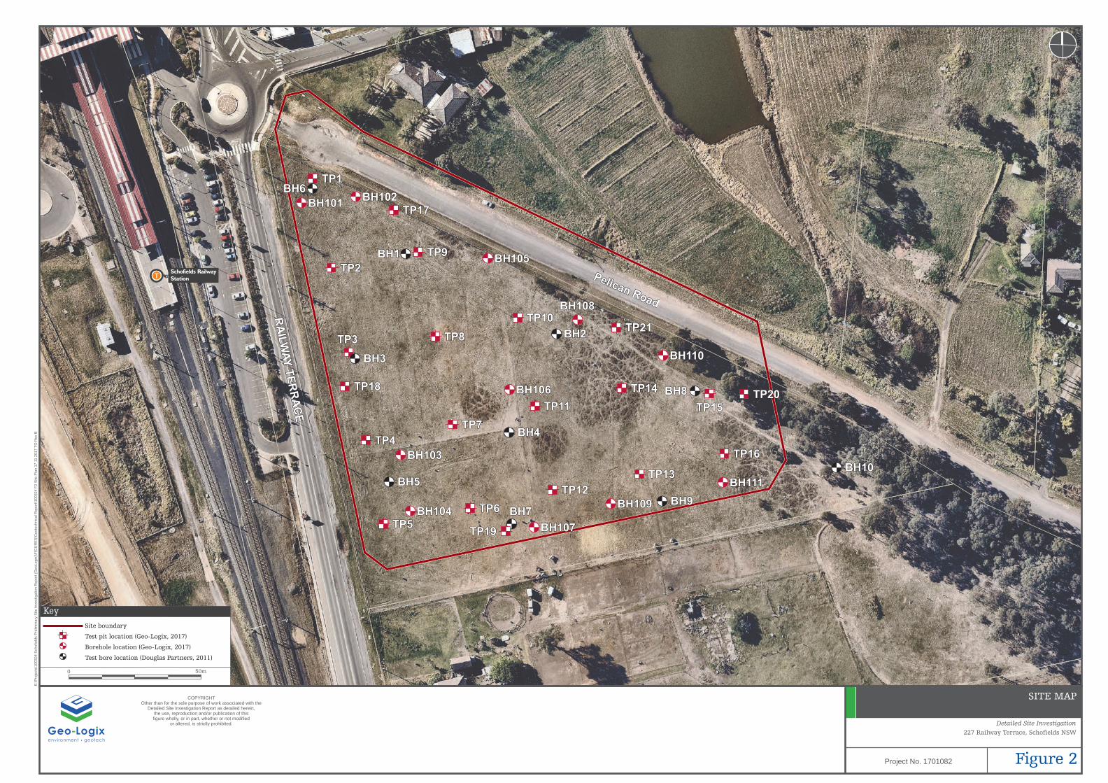
Figure 2: Site Map
ATTACHMENTS
Attachment A: Preliminary Development Plans
Attachment B: Bore Logs
Attachment C: Core Photographs
Attachment D: Douglas Partners Bore Logs
Attachment E: Laboratory Reports
Geotechnical Report 1701104Rpt02FinalV01_20Nov17 ● Page 2
1. INTRODUCTION
Geo-Logix Pty Ltd (Geo-Logix) was engaged by Coles Group Ltd (Coles) to conduct a geotechnical
investigation of the site at Pelican Road and 227 Railway Terrace, Schofields NSW 2762 (Figure 1). The
development is proposed to comprise the proposed Lot 2, currently Pelican Road and the portion of 227
Railway Terrace which will remain following proposed road resumptions, as depicted on Figure 2.
The objective of the geotechnical investigation is to assess the subsurface soil strata in order to provide
soil parameters and engineering recommendations for site earthwork and construction of the proposed
Coles development that would include a shopping centre with at-grade and basement car parking.
1.1 Proposed Development
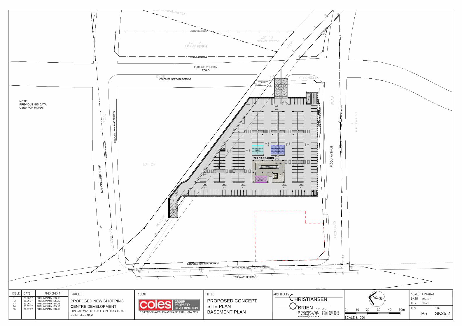
Based on concept plans produced by Christiansen O’Brien Architects (Attachment A), Coles plans to
develop the site as a shopping centre including supermarket, commercial/retail tenancies and on grade
and basement car parking. Geo-Logix understands that the proposed development has the following
parameters.
• Total site area is approximately 21,800 m2;
• The proposed building comprises a single level, steel framed, masonry and concrete clad
building of approximately 8,000 m2 with one level of basement car parking;
• A loading dock to be designed for heavy articulated vehicles;
• Approximately 6,000 m2 of at grade car parking; and
• Outparcel buildings including a proposed McDonalds Restaurant and additional restaurant
and shop spaces.
1.2 Objectives and Scope of Work
The objective of the geotechnical investigation was to provide an assessment of subsurface conditions to
assist with planning of the proposed development.
To satisfy the above objectives Geo-Logix completed the following scope of work:
• Visual appraisal of the site conditions and locality;
• Review of the geological maps for the area;
• Review of the previous Douglas Partners (DP) Report on Geotechnical Assessment
(Project No.: 72397) dated 1 June 2011 and incorporation of relevant data into this report;
• Drilling of eleven test bores (BH106–BH111) by solid stem auger;
• Standard Penetrometer Tests (SPT) were performed within the borings at regular intervals
to assess the relative density and/or consistency of the subsurface soils;
• Continuation of three test bores (BH105, BH110 and BH111) by NMLC rock coring;
• Excavation of 21 test pits across the site using an 8 tonne excavator;
• Logging of the geotechnical borings and test pits by Geo-Logix staff;
Geotechnical Report 1701104Rpt02FinalV01_20Nov17 ● Page 3
• Collection of representative soil samples for selective geotechnical and chemical laboratory
testing;
• Backfilling of the borings and test pits with onsite soils; and
• Provision of this report detailing the results of the above investigation, recommendations
for design and construction of the proposed development.
The field investigations were conducted in October 2017.
2. SITE INFORMATION
2.1 Site Identification and Description
The investigation area comprises the following properties:
Street Address Lot and
Deposited Plan (DP) Approximate Area (m2)
227 Railway Terrace, Schofields NSW 2762 Part of Lot 30 DP 1191922 17,300
Pelican Road, Schofields NSW 2762 Proposed Lot 2* 3,490
Property information sourced from NSW Six Maps.
The following site descriptions are based on observation made during the site investigation conducted by
Geo-Logix on 12–13 and 24 October 2017.
The site is located in a rural residential area on the eastern side of Railway Terrace, Schofields NSW
(Figure 2). The site contains a road reserve to the north and paddocks to the south.
The site comprises part of the property at 227 Railway Terrace and the proposed Lot 2, currently occupied
by Pelican Road, The site is has a combined area of 21,800 m2. A description of each lot is provided below.
227 Railway Terrace
The lot is open grassed land with some scattered trees adjacent to the eastern property boundaries. The
land is currently divided by electrical fencing into three paddocks for the grazing of horses. Equestrian
obstacles are scattered in the southwestern paddock.
Lot 2 Pelican Road
Lot 2 Pelican Road is a proposed lot at the northwest end of Pelican Road, Schofields NSW (Figure 2).
The lot is a long, rectangular-shaped lot encompassing an approximate area of 3,490 m2. At the time of
inspection the site was occupied by Pelican Road which was closed to through traffic and used for
commuter parking for the nearby Schofields train station.
Pelican Road runs through the centre of the road reserve with grassed shoulders along each side. Exposed
road base was observed on either side of the asphalt road. The road is level, and has been cut and filled
relative to surrounding topography. The depth of cut increases in the southeast portion of the road. Several
small stockpiles of illegally dumped household waste were observed adjacent to the road, two of which
contained demolition waste (approximately 5 m3).

Geotechnical Report 1701104Rpt02FinalV01_20Nov17 ● Page 4
2.2 Topography
Topography across 227 Railway Terrace slopes gently down to the southwest. A steepened cut
embankment drops approximately 2 m from the property at 227 Railway Terrace to Pelican Road. Pelican
Road is generally level with open drainage swale along each road shoulder.
Regionally, the site is in a saddle on a low ridge with the surrounding land sloping down to the west and
northeast.
2.3 Regional Geology
Review of the NSW 1:100,000 Sydney Map (Geological Survey of NSW, 1983) indicates the site is on
Middle Triassic age Bringelly Shale of the Wianamatta Group, comprising shale, carboniferous claystone,
claystone, laminite, fine to medium – grained lithic sandstone, rare coal and tuff.
2.4 Regional Hydrology
Reference to the NSW All Groundwater Map (NSW Government, 2017) indicates there are no registered
groundwater bores within a 500 m radius of the site. The groundwater bore map is presented in Attachment
B. It is expected that groundwater would follow the natural regional topography and generally flow towards
the west from 227 Railway Terrace and towards the northeast from Pelican Road.
3. METHOD OF INVESTIGATION
3.1 Investigation Methods
Geotechnical fieldwork was undertaken on 12, 13 and 24 October 2017 by Edward Lilly (Senior
Geotechnical Engineer) and Luke Sheppard (Graduate Environmental Scientist).
Prior to undertaking the borings each location was scanned for underground services and utilities by an
independent utility locator and cross-checked with the results of a ‘Dial Before You Dig’ (DBYD) search.
All test bores were advanced to refusal utilising a truck mounted drill rig with solid stem augers and a “V”
shaped hardened steel bit (V-bit).
Borings BH101 and BH103 were advanced further with use of a Tungsten Carbide bit (TC-bit) and
terminated at SPT refusal.
Borings BH106 and BH108 were advanced further by TC-bit and terminated at 4.3 mbg.
Boring BH109 was advanced further by TC-bit to refusal at 2.7 mbg.
Borings BH105, BH110 and BH111 were advanced further to TC-bit refusal and then rock cored to
approximately 6.0 mbg. BH107 was advanced further to 7.5 mbg with use of TC-bit and was not rock cored
due to quality of rock.
Standard Penetrometer Tests (SPTs) were completed in each test bore using a donut hammer. SPTs were
completed at depths of 1.0 mbg and at 1.5 m intervals thereafter.

Geotechnical Report 1701104Rpt02FinalV01_20Nov17 ● Page 5
Twenty one test pits (TP1–TP21) were excavated using an 8 tonne excavator with a 450 mm wide bucket.
Test pit locations were selected to provide broad site coverage. The test pits were excavated to final depths
ranging from 0.5 to 2.7 mbg.
During drilling the encountered soils were logged in accordance with the Unified Soil Classification System
(USCS). Representative samples of soil and rock were submitted to Eurofins | MGT (Eurofins) and
Macquarie Geotech for selective characterisation and chemical tests.
At the completion of drilling/excavation each test bore or test pit was reinstated with soil cuttings.
The location of each test bore and test pit was estimated using measurements from existing features. A
copy of the bore logs and SPT results are provided in Attachment B. Photos of rock cores are presented in
Attachment C.
4. PREVIOUS GEOTECHNICAL REPORT
4.1 Douglas Partners (2011)
Douglas Partners (DP) was commissioned by Coles to provide a Preliminary Geotechnical Report for a
proposed Shopping Centre at 227 Railway Terrace, Schofield NSW (Project No.: 73056 Document No.: 1)
in June of 2011. DP’s assessment was based on ten borings (BH1–BH10) completed on 3 and 6 May 2011.
Geo-Logix has incorporated the results of DP’s assessment into the current report.
The previous bore logs are presented as Attachment D.
5. INVESTIGATION RESULTS
5.1 Surface and Subsurface Conditions
The following sections contain a summarised account of the site surface and subsurface. For detailed
descriptions of individual locations please refer to the attached boring logs.
Site Surface
Vegetation of the site surface generally comprised grass with a cluster of shrubs towards the east of 227
Railway Terrace. Topsoil consisted of light brown sandy loam with a typically thin root zone of
approximately 100 mm.
Filling
Based on previous environmental test pitting, fill in the Pelican Road reserve appears to extend to 0.15 –
0.30 mbg.
Hard Clay
Onsite native soil typically comprised residual, moderate red to moderate reddish brown, damp, hard, high
plasticity Clay (CH) extending to weathered rock at 1–2 mbg.
Shale and Sandstone Rock
Onsite bedrock comprised shale in the western portion of the site and sandstone in the eastern portion of
the site. Layered laminite and sandstone were observed near the shale sandstone boundary. Weathered
Geotechnical Report 1701104Rpt02FinalV01_20Nov17 ● Page 6
(Class IV-V) rock was typically encountered at 1–2 mbg. Sandstone in the eastern portion of the site
beneath the proposed shopping centre and basement car park transitioned to medium to high strength
sandstone (Class III or better) at approximately 5 mbg.
5.2 Groundwater
Groundwater was not encountered during this investigation.
5.3 Laboratory Results
Representative samples of soil were collected during the fieldwork and submitted to Eurofins and SGS for
NATA accredited testing. Tests included:
• Atterberg Limit tests to confirm the USCS field classifications of representative soil samples
to assist with classification and description and to facilitate liquefaction analysis;
• Shrink Swell Index (SSI) testing to facilitate site classification in accordance with AS2870–
2011;
• Standard Maximum Dry Density (SMDD), Optimum Moisture Content (OMC) and California
Bearing Ratio (CBR) testing to assist with pavement and slab design;
• Aggressivity testing (electrical conductivity, sulphate, chloride and pH) to assess the
exposure classification of the soil with respect to buried structural concrete and/or exposed
steel; and
• Unconfined Compressive Strength (UCS) and Point Load Strength tests to assist with the
determination of rock strength and rippability.
The laboratory test results are presented in Attachment E. A summary of the results is provided in the
following sections.
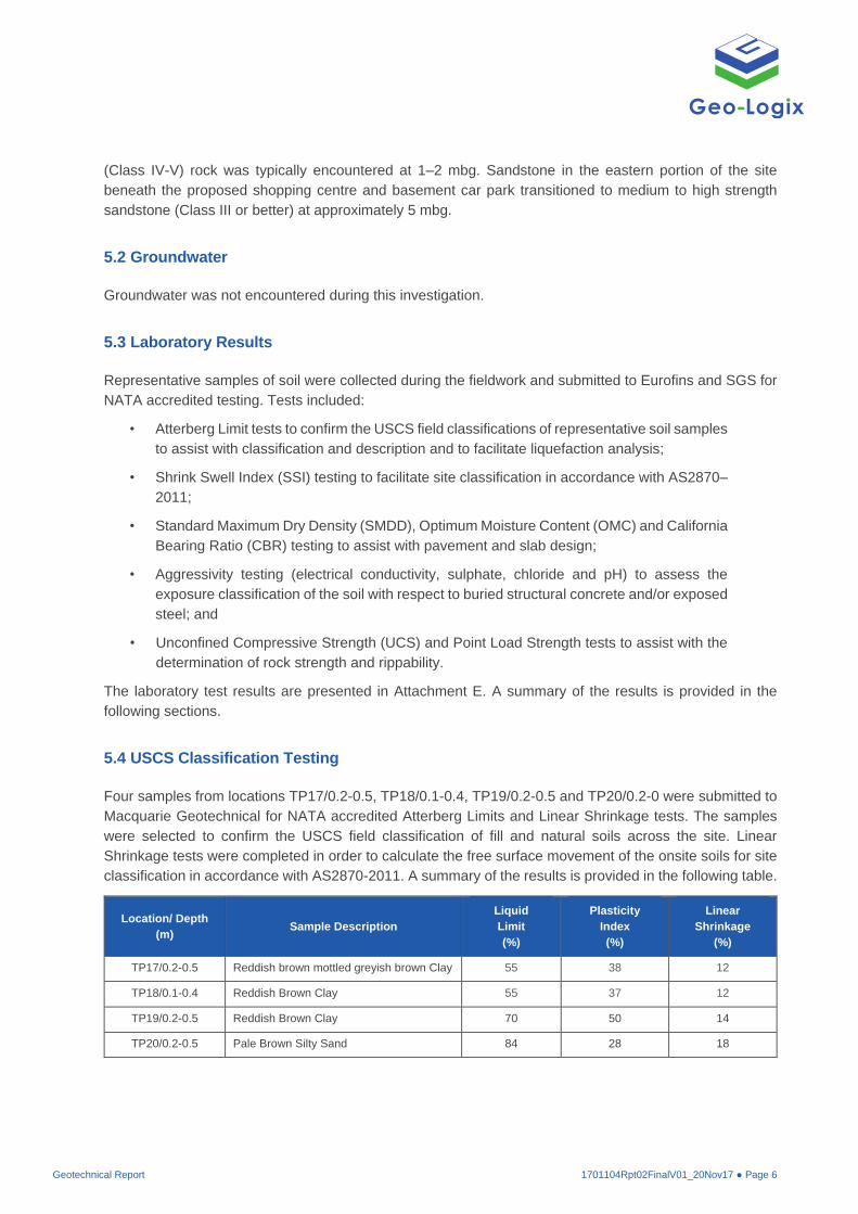
5.4 USCS Classification Testing
Four samples from locations TP17/0.2-0.5, TP18/0.1-0.4, TP19/0.2-0.5 and TP20/0.2-0 were submitted to
Macquarie Geotechnical for NATA accredited Atterberg Limits and Linear Shrinkage tests. The samples
were selected to confirm the USCS field classification of fill and natural soils across the site. Linear
Shrinkage tests were completed in order to calculate the free surface movement of the onsite soils for site
classification in accordance with AS2870-2011. A summary of the results is provided in the following table.
Location/ Depth
(m) Sample Description
Liquid
Limit
(%)
Plasticity
Index
(%)
Linear
Shrinkage
(%)
TP17/0.2-0.5 Reddish brown mottled greyish brown Clay 55 38 12
TP18/0.1-0.4 Reddish Brown Clay 55 37 12
TP19/0.2-0.5 Reddish Brown Clay 70 50 14
TP20/0.2-0.5 Pale Brown Silty Sand 84 28 18

Geotechnical Report 1701104Rpt02FinalV01_20Nov17 ● Page 7
The Atterberg Limit test results indicate whether the fine grained component of the samples is classified as
Silt or Clay as well as the reactivity of the material. The potential for surface movement based on the
reactivity of the soil to changes in moisture is discussed in Section 6.7.
5.5 Shrink Swell Index (SSI)
An undisturbed 50 mm diameter thin walled push-tube sample from locations BH101/1-1.35, BH103/0.5-
0.8, BH106/0.5-0.8 and BH111/0.5-0.9 were submitted to Macquarie Geotechnical for SSI testing. The
sample was selected as representative of onsite clay soils. SSI testing was conducted to facilitate site
classification in accordance with AS 2870-2011.
The push-tube sample was split into two subsamples. One subsample was dried to laboratory conditions
and thereafter oven dried and the ultimate shrinkage strain recorded. The remaining subsample was placed
in a consolidometer and distilled water added after initial settlement. The final swell strain was measured
at the completion of primary swelling. The SSI was then derived based on an effective suction range of 1.8
pF.
Location/ Depth (m) Sample Description
Total
Shrinkage
(%)
Total
Swell
(%)
Shrink
Swell
Index
BH101/1-1.35 Light greyish pink Fat Clay (CH) 2.7 8.37 3.8
BH103/0.5-0.8 Moderate red Fat Clay (CH) 1.7 4.24 2.1
BH106/0.5-0.8 Red grey Fat Clay (CH) 2.1 4.76 2.5
BH111/0.5-0.9 Moderate red mottles greyish brown Fat Clay (CH) 2.3 4.05 2.4
The potential for surface movement is discussed in Section 6.7.
5.6 Californian Bearing Ratio
Representative bulk samples were collected from locations TP17/0.2-0.5, TP18/0.1-0.4, TP19/0.2-0.5 and
TP20/0.2-0.5 to obtain a site-wide understanding of CBR values for use in pavement design. These
samples were submitted to Macquarie Geotech for NATA accredited testing of the CBR.
The CBR samples were remoulded in the laboratory and compacted to 100% SMDD at OMC. Prior to
testing, the samples were soaked for four days under a surcharge load of 4.5 kg. The soaked CBR values
are provided in the following table.
Location/
Depth (m) Sample Description
SMDD
(t/m3)
OMC
(%)
CBR Value
(%)
Swell After
Soaking
(%)
TP17/0.2-0.5 Reddish brown mottled greyish brown Clay (CH) 1.749 17.8 4.5 1.8
TP18/0.1-0.4 Reddish Brown Clay (CH) 1.670 18.6 4.0 2.2
TP19/0.2-0.5 Reddish Brown Clay (CL) 1.641 20.6 6.0 1.8
TP20/0.2-0.5 Pale Brown Silty Sand (SM) 1.448 28.5 11.0 1.1
Pavement design based on these CBR results is discussed in Section 6.9.

Geotechnical Report 1701104Rpt02FinalV01_20Nov17 ● Page 8
5.7 Exposure Classification Tests
Soil samples from locations TP4 at 0.0–0.1 and 0.6–0.7 mbg, TP8 at 0.0–0.1 and 0.6–0.7 mbg, TP12 at
0.0–0.1 and 0.6–0.7 mbg and TP16 at 0.0–0.1 and 0.6–0.7 mbg were submitted to Eurofins for NATA
accredited testing of pH, sulphate, chloride and electrical conductivity to determine the exposure
classification (or aggressiveness/corrosiveness potential of the soil) with respect to buried steel and/or
concrete. The samples were selected as representative of onsite soils in which foundations were expected.
To determine the aggressiveness of the soil and water environment on concrete or steel, the chemical test
results are compared to Tables 6.1 and 6.3 from Section 6 of the Australian Standard AS2159 – 2009. This
section provides assessment criteria to assess the ‘exposure classification’ for a concrete or steel pile. The
Standard has two classes of soil conditions:
• Type A – high permeability soils below groundwater; and
• Type B – low permeability soils and all soils above groundwater.
Based on the chemical testing results, the Standard provides a range of ‘exposure classifications’
from non-aggressive to very severe. For the range of chemical conditions in the soil surrounding
the structure, the condition leading to the most severe aggressive conditions is adopted. A summary
of the soil results is provided in the following table.
Location/
Depth (m)
Soil
Condition
Electrical
Conductivity
(EC) (dS/m)
Soil
Texture
Factor
Extract
Electrical
Conductivity
(ECe) (dS/m)
Electrical
Resistivity
(Ω∙cm)
pH Chloride
(mg/kg)
Sulphate
(mg/kg)
TP4/0.0-0.1 B 0.014 14 0.20 71,000 6.2 63 34
TP4/0.6-0.7 B 0.031 6 0.19 32,000 5.3 440 250
TP8/0.0-0.1 B 0.044 14 0.62 23,000 5.7 67 <30
TP8/0.6-0.7 B 0.380 6 2.3 2,600 5.5 540 200
TP12/0.0-0.1 B <0.010 14 <0.14 >100,000 6.5 6.5 <30
TP12/0.6-0.7 B 0.220 6 1.3 4,60 5.1 320 160
TP16/0.0-0.1 B 0.012 14 0.17 83,000 6.0 65 <30
TP16/0.6-0.7 B 0.024 6 0.14 42,000 6.0 94 37
The potential aggressivity of an environment towards concrete and steel is dependent on the sulphate,
chloride and pH levels of the soil. Soil aggressivity is discussed in Section 6.10. Site Salinity is discussed
in Section 6.11.
5.8 Uniaxial Compressive Strength Test
Three rock core samples from boreholes BH105 at 5.0–5.1 mbg, BH110 at4.9–5.0 mbg and BH111 at 5.0–
5.1 mbg were submitted to Macquarie Geotech for NATA accredited testing of Uniaxial Compressive
Strength (UCS) to facilitate bearing capacity and excavatability of the rock. Each rock core samples was
cut to a height/diameter ratio of between 2 and 3, and then loaded axially into a compression machine.
Compression was applied uniaxially at a constant rate until failure occurs and the failure load recorded.
A summary of the UCS test results is provided in the following table.
Geotechnical Report 1701104Rpt02FinalV01_20Nov17 ● Page 9
Location/
Depth (m) Rock Type UCS (MPa)
BH105/5-5.1 Sandstone 43.4
BH110/4.9-5 Sandstone 21.1
BH111/5-5.1 Sandstone 42.6
The excavatability of rock is discussed in Section 6.2. Allowable bearing capacities of foundations on rock
are discussed in Section 6.9.
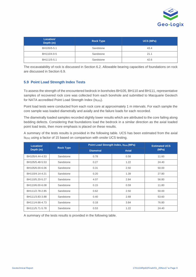
5.9 Point Load Strength Index Tests
To assess the strength of the encountered bedrock in boreholes BH105, BH110 and BH111, representative
samples of recovered rock core was collected from each borehole and submitted to Macquarie Geotech
for NATA accredited Point Load Strength Index (Is(50)).
Point load tests were conducted from each rock core at approximately 1 m intervals. For each sample the
core sample was loaded diametrally and axially and the failure loads for each recorded.
The diametrally loaded samples recorded slightly lower results which are attributed to the core failing along
bedding defects. Considering that foundations load the bedrock in a similar direction as the axial loaded
point load tests, then more emphasis is placed on these results.
A summary of the tests results is provided in the following table. UCS has been estimated from the axial
Is(50) using a factor of 15 based on comparison with onsite UCS testing.
Location/
Depth (m) Rock Type
Point Load Strength Index, Is(50) (MPa) Estimated UCS
(MPa) Diametral Axial
BH105/4.44-4.53 Sandstone 0.78 0.58 11.60
BH105/5.48-5.53 Sandstone 0.27 1.22 24.40
BH105/6.00-6.06 Sandstone 0.31 2.50 50.00
BH110/4.14-4.21 Sandstone 0.20 1.39 27.80
BH110/5.20-5.27 Sandstone 4.07 2.84 56.80
BH110/6.00-6.08 Sandstone 0.15 0.59 11.80
BH111/2.78-2.85 Sandstone 0.62 2.50 50.00
BH111/3.83-3.88 Sandstone 0.40 2.68 53.60
BH111/4.66-4.73 Sandstone 0.18 3.84 76.80
BH111/5.71-5.78 Sandstone 0.53 1.22 24.40
A summary of the tests results is provided in the following table.

Geotechnical Report 1701104Rpt02FinalV01_20Nov17 ● Page 10
6. DISCUSSION
6.1 Earthworks
The subject site should be prepared in accordance with AS 3798-2009 Section 6.1 and filled in accordance
with AS 3798-2009 Section 6.2.
Initial Site Preparation
Initially vegetation, topsoil and other surface features such as road pavements should be stripped from the
site, including an area extending at least 1.5 m laterally beyond any planned structures or improvements.
Geo-Logix expects that the thin layer of onsite topsoil will be removed during vegetation scraping.
Utilities should be located and rerouted as necessary and any abandoned pipes or utility conduits should
be removed or filled with grout. Utility trench excavations must be cut to competent bearing soils and
backfilled with properly compacted Structural Fill.
Existing Pavements and Fill
The surfacing of Pelican Road appears to comprise a thin bituminous pavement. Following stripping during
initial site preparation this material may be crushed or broken up and used as Fill. Mixing with soil fill and
placement at least 0.5 m below final subgrade is recommended.
Limited fill material is expected to be encountered onsite, primarily along Pelican Road. Geo-Logix
recommends that existing onsite fill be excavated during initial site preparation. Where anthropogenic
material is encountered, sieving of the excavated Fill is recommended. Fill meeting the criteria for structural
filling below may be stockpile for reuse on site.
0 15 30 45 60
2.0
3.0
4.0
5.0
6.0
7.0
0.0 1.0 2.0 3.0 4.0
UCS (Mpa)
De
pth
(m
bg
)
Is(50) (MPa)
Is(50) and UCS vs Depth
BH105 (Is₍₅₀₎)
BH110 (Is₍₅₀₎)
BH111 (Is₍₅₀₎)
BH105 (UCS)
BH110 (UCS)
BH111 (UCS)

Geotechnical Report 1701104Rpt02FinalV01_20Nov17 ● Page 11
Structural Filling
Where the above site preparation procedures create excavations below the proposed final grade, the
excavations should be backfilled with properly compacted Structural Fill. Materials selected for use as
Structural Fill should not contain organic matter, waste construction debris, or deleterious materials. Fill
materials should be granular material or be of low or medium plasticity. Existing onsite Fill meeting the
above criteria may be used as Structural Fill. Under no circumstances should topsoil or other organic-laden
soils be placed as Fill beneath or within 1.5 horizontal metres of building, car park, or other structural areas.
Once final grade is reached in cut areas, and prior to Fill placement in areas of the site that will receive
new Fill, the subgrade should be evaluated by a geotechnical engineer or their representative. Following
subgrade evaluation the exposed subgrade should be test-rolled in accordance with AS 3798-2009. Any
unstable areas failing the evaluation or test-roll should be excavated to the depth of competent bearing
material and filled in accordance with the general site Fill placement methodology outlined below.
Fill materials should be placed in individual lifts of 300 mm or less loose measurement and compacted
using a sheep’s foot roller for cohesive soils and a smooth drum roller for cohesionless soils. Where the
use of full sized compaction equipment is not possible due to confined space or other restrictions, thinner
lifts may be required. “Bridging Lifts” should not be used without approval by a geotechnical engineer. Fill
should be compacted to a minimum of 98% of standard compaction with a moisture content within ±2% of
the optimum moisture content.
Test rolling and Fill placement is to be undertaken under Level 1 Supervision. AS 3798-2009 Section 8.7
specifies compaction density testing of Fill at a frequency of 1 test per layer per material type per 2500 m2
or 1 test per 500 m3 distributed reasonably evenly throughout full depth for large scale operation such as
the proposed development.
6.2 Excavations
Geo-Logix understands that cut and fill operations are proposed to achieve final site elevations.
Excavations of fill and natural soils will be achievable by excavator. Excavation of rock is expected to be
required to achieve final subgrade elevation in the area of the proposed basement carpark. Assistance of
ripper, rock hammer and rock saw are expected to be needed for this excavation.
Construction vibrations, groundwater management, batter and shoring of excavations are discussed in the
following sections.
6.3 Groundwater Inflow
Groundwater was not encountered within the depth of expected onsite excavations. However, seepage
may be expected to occur along the soil rock interface, either due to broken services or after periods of
heavy rains. If required, dewatering of excavations may be completed by sump and pump methods.
Permanent drainage systems should allow for water collection of seepage and flows from joints, with sumps
and pumps suitably sized to dispose of the water in accordance with council and EPA regulations. Based
on iron banding observed in the rock profile groundwater is expected to have significant concentrations of
iron which will precipitate as iron oxide/hydroxide sludge. This should be taken into account when designing
drainage lines and pump-out systems through provision for maintenance to remove the sludge incorporated
into the design.

Geotechnical Report 1701104Rpt02FinalV01_20Nov17 ● Page 12
6.4 Temporary and Permanent Batter Slopes
For shallow excavations undertaken prior to other construction works where all surcharge loads, including
plant and stockpiled material are kept well clear of the top of the batters, minimum batter slopes are
recommended as 1H:1V for temporary batters and 2H:1V for permanent batters. Where steeper permanent
batters are required slope reinforcement may be considered. For batters taller than 2 m localised
assessment of batter slopes is recommended.
Stormwater runoff should be directed away from the tops of batters by use of berm drains. Where runoff
must be directed down the face of a batter the batter drains/chutes should be lined to prevent erosion.
Properly installed silt fence should be used at the base of batter slopes to prevent offsite migration of
sediment. Scouring of excavation faces due to runoff should be repaired prior to further works within the
excavation(s). All permanent batters should be protected from erosion by vegetation or other measures
and designed with adequate surface and subsurface drainage.
The contractor is solely responsible for temporary excavation design and should evaluate the soil exposed
in the excavations as part of the contractor’s safety procedures. In no case should slope height, slope
inclination, or excavation depth, including utility trench depth, exceed those specified in local, state, and
national safety regulations.
6.5 Retaining Walls and Shoring
The following earth pressure coefficients are recommended for use in design of temporary and permanent
retaining structures:
Retained Material Bulk Density
(kN/m3)
Earth Pressure Coefficients
At rest (K0) Active (Ka) Passive (Kp)
Clayey Fill and
Natural Soils 20 0.75 0.57 1.75
Sandy Fill and
Natural Soils 21 0.50 0.33 3.00
Weathered
Shale/Sandstone 25 0.25 0.15 7.50
Medium to High
Strength Sandstone 25 -- -- --
-- = not applicable.
The ‘at rest’ earth pressure coefficient (K0) is suitable for retaining structures where anchors or other
methods restrain retaining wall movement or where significant movements cannot be tolerated (rigid wall).
A uniform or trapezoidal earth pressure distribution should be adopted. It should be noted that shoring,
which is designed for this ‘at rest’ coefficient, will still undergo some lateral movements.
The active earth pressure coefficient (Ka) is suitable for retaining structures allowing movement of the top
such as cantilevered pile walls. For these structures the pressure acting on the wall can be estimated on
the basis of a triangular earth pressure distribution.
The passive earth pressure coefficient (Kp) is suitable for the calculation of resisting forces at the toe of
concrete, reinforced stone, or masonry walls.
Geotechnical Report 1701104Rpt02FinalV01_20Nov17 ● Page 13
Design of all retaining structures should be undertaken in accordance with AS4678-2002. Furthermore, the
design of any retaining structures should make allowance for all applicable surcharge loadings including
construction activities around the perimeter of the excavation, traffic loadings and adjacent buildings.
Consideration should be given to the possibility of a hydrostatic pressure due to build-up of water behind
the wall (e.g. from broken services), unless permanent subsurface drainage can be provided.
6.6 Construction Induced Vibrations
If percussive excavation equipment (e.g. rock hammer) is used, consideration must be given to possible
construction induced ground vibration. Construction induced ground vibration is unlikely to be an issue at
the site unless heavy impact tools are required for excavation. The use of other techniques which do not
involve impact (e.g. rock saws), although less productive, would reduce or possibly eliminate risks of
damage due to vibrations.
If adopting a rock hammer or similar, on-site guidance by a vibration specialist is recommended during the
early part of excavation. This should include vibration characterisation trials that are used to define vibration
levels for the selected equipment.
Peak Particle Velocity (PPV) is usually the adopted measure of ground vibration and the safe limits depend
on the sensitivity of the adjoining structures and services. There are a number of Australian and overseas
publications that provide vibration velocity guideline levels (or safe limits) including:
• Australian Standard AS2187.2-2006 Explosives - Storage and use - Use of explosives -
Appendix J: Ground Vibrations and Airblast Overpressure;
• DIN 4150 – Part 3 – 1999. Effects if Vibration on Structures;
• Department of Environment and Conservation NSW, 2006. Assessing Vibration: a
technical guideline;
• British Standard BS 7385-1:1990. Evaluation and measurement for vibration in buildings.
Guide for measurement of vibrations and evaluation of their effects on buildings;
• British Standard BS 7385-2:1993. Evaluation and measurement for vibration in buildings.
Guide to damage levels from groundborne vibration.
The most appropriate guidelines levels for the proposed excavation work are provided in AS2187.2-2006,
which refers to guideline values from BS7385-2 for the prevention of minor or cosmetic damage occurring
in structures from ground vibration. Additionally, the guideline levels provided in DIN 4150 Part 3 is
considered an appropriate source for guideline levels.
Ideally, safe limits should be determined by a specialist vibration consultant. However, as a preliminary
guide, and considering the above guidelines and the type of adjoining structures present, Geo-Logix
recommend a maximum PPV of 10 mm/sec (measured at the foundations of adjoining structures) to prevent
cosmetic and structural damage.
The PPV limits of 10 mm/sec are expected to be achievable if rock breaker equipment or other excavation
methods are restricted as indicated in the following table:

Geotechnical Report 1701104Rpt02FinalV01_20Nov17 ● Page 14
Distance from
Adjoining
structure (m)
Maximum Peak Particle Velocity 10 mm/sec*
Equipment Operating Limit
(% of Maximum Capacity)
1.5 to 2.5 300 kg rock hammer 50
2.5 to 5.0
300 kg rock hammer
or
600 kg rock hammer
100
50
5.0 to 10.0
600 kg rock hammer
Or
900 kg rock hammer
100
50
Geo-Logix notes human discomfort levels caused by vibration are typically less than the levels that are
likely to cause cosmetic or structural damage to structures. Therefore, neighbours may lodge complaints
before any cosmetic or structural damage occurs.
Geo-Logix recommends dilapidation surveys be carried out on neighbouring buildings prior to construction
to confirm that the construction works are not causing damage. These surveys should be agreed to, and
the report signed, by the owners of the adjacent building prior to work commencing.
6.7 Site Classification
Considering the depth of existing onsite fill along pelican road, the appropriate geotechnical site
classification is Class ‘P’ in accordance with AS2870-2011.
Free surface movement of the natural soil profile has been calculated based on the results of Shrink Swell
Index testing and Linear Shrinkage testing (Cameron, 1989). The natural soil profile is considered to be
equivalent to a Class ‘H1’, with a characteristic free surface movement (ys) of 40-60 mm with changes in
moisture (AS2870-2011).
Geo-Logix notes that this site classification has not included the effects of trees, poor site drainage, leaking
plumbing, and exceptionally wet or dry moisture conditions.
6.8 Foundations
Geo-Logix recommends that footings for the proposed shopping centre and other onsite structures be
founded on consistent mediums to minimise any potential differential settlements. However, depending on
the building loads and whether the structures are designed to be relatively flexible, this may not be
significant.
Provided new Structural Fill is placed in a controlled manner as advised in Section 6.1, native soils and
Structural Fill would be capable of supporting shallow footings. Assuming typical embedment of 0.5 mbg
and allowable settlement of 25 mm shallow footings may be designed based on an allowable bearing
capacity of 200 kPa.
Geo-Logix recommend that foundation subgrade surfaces be observed and tested by a geotechnical
engineer using Dynamic Cone Penetrometer (DCP) testing equipment or other satisfactory methods prior
to steel or concrete placement. Any unsatisfactory soil detected during this evaluation should be undercut
as directed by the geotechnical engineer. Footing excavations should be protected from surface water run-
off; if water is allowed to accumulate within a footing excavation and soften the bearing soils, the deficient
soils should be removed from the excavation prior to concrete placement.
Geotechnical Report 1701104Rpt02FinalV01_20Nov17 ● Page 15
Allowable bearing pressure and adhesion for deep foundations including bored piers and basements
founded on rock are summarised in the following table.
Bearing Stratum Typical Depth
(mbg)
Allowable
Bearing
Pressure
(MPa)
Allowable
Adhesion
(kPa)*
Young’s
Modulus, Es
(MPa)
Estimated
Settlement
Class IV-V Shale/Sandstone 2.0–5.0 700 35 50,000
1% of Footing
Width or Pier
Base
Class III or better Shale >5.0 1,000 50 200
1% of Footing
Width or Pier
Base
Class III or better Sandstone >5.0 3,500 175 350
1% of Footing
Width or Pier
Base
*For pier foundations only, not applicable for footings. Assumes a clean socket of roughness R2 or better.
The bearing stratum should be verified prior to the placement of rebar or concrete. Pier borings should be
filled on the same day as drilling. Pier borings should be dewatered immediately prior to placement of
concrete. If required dewatering for pier borings may be accomplished by sump pump.
All footing systems should be designed and constructed in accordance with the recommendations
contained in AS 2870-2011 and/or AS 2159-2009 by a suitably qualified and experienced structural
engineer.
6.9 Ground Slabs and Pavements
Slab and pavement designs are based on the CBR and modulus of the subgrade materials encountered
after any excavation or re-grading has taken place. The principal aim of the subgrade preparation is to
provide a uniform foundation over the entire slab/pavement formation which will not give rise to unevenness
in the slab/pavement surface under the design loads. The final subgrade, following the earthworks
recommended in Section 6.1, should comprise native soils or new Structural Fill. Both are considered to
be suitable as a subgrade provided the material performs satisfactorily under test-rolling as detailed in
AS3798-2007. Existing uncontrolled Fill, in its current state, is not considered to be a suitable subgrade.
Final subgrade should perform under test-rolling and be compacted to at least 98% standard compaction.
Based on the results of laboratory testing a design CBR of 4 is appropriate for pavements and slabs with
a subgrade comprised of onsite soil or new structural fill.
In order to provide uniform support beneath any proposed floor slab-on-grade, Geo-Logix recommends
that floor slabs be underlain by a minimum of 100 mm of free-draining (a maximum particle size of 19 mm
with less than 5 percent material passing the 75 µm sieve), well graded gravel or crushed rock base course.
Exterior slabs and pavements should be isolated from the building. These slabs should be reinforced to
function as independent units. Movement of these slabs should not be transmitted to the building foundation
or superstructure.

Geotechnical Report 1701104Rpt02FinalV01_20Nov17 ● Page 16
6.10 Aggressivity/Exposure Classification
Based on the preliminary exposure classification test results, and in accordance with AS3600-2009 and
AS2159-2009, steel and concrete structures in contact with soil should be designed based on no less than
mildly aggressive, A2, exposure.
6.11 Salinity Risk
Soil salinity risk is based on extract electrical conductivity (ECe), the product of electrical conductivity of soil
measured in solution and a multiplication factor based on soil texture. Based on the range of soil electrical
conductivities from <0.01 to 0.38 dS/m encountered and soil texture multiplication factors of 14 for sandy
loam topsoil and 6 for the underlying heavy clay, the site soils have extract electrical conductivities ranging
from 0.14 to 2.3 dS/m. These results indicate that onsite soils are non-saline (ECe < 2) to slightly saline
(ECe of 2–4) (Department of Land and Water Conservation NSW, 2002).
6.12 Earthquake Design
Structural design for earthquake loads should be carried out in accordance with the relevant provisions in
AS1170.4–2007. At this preliminary stage, based on the subsurface soil profile encountered during this
investigation, and with reference to Tables 3.2 and 4.1 of AS1170.4, the site subsoil class is considered to
be Ce (Shallow Soil) with a hazard factor (Z) of 0.08.
Geotechnical Report 1701104Rpt02FinalV01_20Nov17 ● Page 17
7. LIMITATIONS
The recommendations submitted are based on the available project information and the subsurface
information obtained by Geo-Logix. If there are any revisions to the plans for this project or if deviations
from the subsurface conditions noted in this report are encountered during construction, Geo-Logix should
be notified immediately to determine if there are consequences to the recommendations provided in this
report. If Geo-Logix is not retained to perform these functions, Geo-Logix cannot be responsible for the
impact of those conditions on the performance of the project.
The geotechnical engineer warrants that the findings, recommendations, specifications, or professional
advice contained herein have been made in accordance with generally accepted professional geotechnical
engineering practices in the local area at the time of this report. No other warranties are implied or
expressed.
After the plans and specifications are more complete the geotechnical engineer should be provided with
the opportunity to review the final design plans and specifications to assess whether our engineering
recommendations have been properly incorporated into the design documents. At that time, it may be
necessary to submit supplementary recommendations. This report has been prepared for the exclusive
use of Coles Development Group Pty Ltd and their consultants for the specific application to the
construction of the proposed Coles Shopping Centre at 227 Railway Terrace, Schofields NSW.

Geotechnical Report 1701104Rpt02FinalV01_20Nov17 ● Page 18
8. REFERENCES
Australian Standard (2007) AS1170.4–2007 Structural design actions – Earthquake actions in Australia,
Standards Australia.
Australian Standard (2007) AS3798–2007 Guidelines on earthworks for commercial and residential
developments, Standards Australia.
Australian Standard (2009) AS2159–2009 Piling Design and Installation, Standards Australia.
Australian Standard (2009) AS3600–2009 Concrete Structures, Standards Australia.
Australian Standard (2011) AS2870–2011 Residential slabs and footings, Standards Australia.
Bowles, J. E. (1996) Foundation Analysis and Design, 5th Edition, Mc-Graw Hill, Inc. New York.
Department of Land and Water Conservation NSW (2002) Site Investigations for Urban Salinity.
Douglas Partners (2011) Report on Preliminary Geotechnical Investigation, Proposed Coles Development
227 Railway Terrace, Schofields, Prepared for Coles Group Property Developments, Project 72397.00,
May 2011.
Geological Survey of New South Wales (1991) Penrith 1:100 000 Geological Sheet 9030, 1st edition.
Geological Survey of New South Wales, Sydney.
NSW Department of Primary Industries (2016) All Groundwater Map, http://allwaterdata.water.nsw.gov.au/
water.stm. Accessed 17/08/2017.

FIGURES

Douglas SidingReserve
Douglas SidingReserve
CRANEBROOK DEFENCECRANEBROOK DEFENCE
SITE LOCATION
SCHOFIELDS ROAD
SCHOFIELDS ROAD
Argowan Road
Argowan Road
Walk
er
Str
eet
Walk
er
Str
eet
BLACKTOWNLGA
RA
ILW
AY
TE
RR
AC
E
RA
ILW
AY
TE
RR
AC
E
SchofieldsSchofields
Seldon Street
Seldon Street
Pelic
an
Ro
ad
Pelic
an
Ro
ad
Brid
ge
Stre
et
Brid
ge
Stre
et
Advance Street
Advance Street
Schofields Railway
Station
BURDEKIN ROADBURDEKIN ROAD
E:\
Pro
jects
\10
03
24
Sch
ofie
lds
Pre
limin
ary
Site
Inve
stig
atio
nR
ep
ort
(Ge
oL
og
ix)\
FIG
UR
ES
\Ge
ote
ch
nic
alR
ep
ort
\10
03
24
F1
Site
Lo
ca
tio
n1
711
20
17
TO
SITE LOCATION
Figure 1
Geotechnical Report
227 Railway Terrace, Schofields NSW
Project No. 1701104
COPYRIGHTOther than for the sole purpose of work associatedwith the Geotechnical Report as detailed herein,the use, reproduction and/or publication of thisfigure wholly, or in part, whether or not modified
or altered, is strictly prohibited.
0 400m
Site boundary
Parks and reserves
Existing native vegetation/woodland
Main road
Road
Watercourse
Key
RA
ILW
AY
TE
RR
AC
E
RA
ILW
AY
TE
RR
AC
E
Pelican Road
Pelican Road
Schofields Railway
Station
TP1TP1
TP2TP2
TP9TP9
TP3TP3 TP8TP8
TP4TP4
TP7TP7
TP5TP5
TP6TP6
TP11TP11
TP14TP14
TP12TP12
TP13TP13
TP15TP15
TP16TP16
TP10TP10
BH105BH105
BH102BH102BH101BH101
BH108BH108
BH106BH106
BH103BH103
BH104BH104
BH107BH107
BH109BH109
BH110BH110
BH6BH6
BH1BH1
BH2BH2
BH8BH8
BH9BH9
BH4BH4
BH7BH7
BH5BH5
BH3BH3
BH111BH111
TP17TP17
TP18TP18
TP19TP19
TP20TP20
TP21TP21
BH10BH10
0 50m
Site boundary
Test pit location (Geo-Logix, 2017)
Borehole location (Geo-Logix, 2017)
Test bore location (Douglas Partners, 2011)
Key
SITE MAP
Figure 2
Detailed Site Investigation
227 Railway Terrace, Schofields NSW
Project No. 1701082
COPYRIGHTOther than for the sole purpose of work associated with the
Detailed Site Investigation Report as detailed herein,the use, reproduction and/or publication of thisfigure wholly, or in part, whether or not modified
or altered, is strictly prohibited.
E:\
Pro
jects
\10
03
24
Sch
ofie
lds
Pre
limin
ary
Site
Inve
stig
atio
nR
ep
ort
(Ge
oL
og
ix)\
FIG
UR
ES
\Ge
ote
ch
nic
alR
ep
ort
\10
03
24
F2
Site
Pla
n1
711
20
17
TO
Re
vB

ATTACHMENT A

NEW
SUPERMARKET
3800m²
PT 41.51
1FE 30.89
1FE
30.65
1FE
30.79
1FE 31.14
1FE
31.75
1FE
32.35
1FE
32.98
1FE 33.62
1FE 34.11
1FE
34.72
1FE 34.82
1FE 34.87
1FE
34.89
1FE
34.63
33.84
32.27
30.77
34.58
33.49
LOT BOUNDARY
PROPOSED NEW ROAD RESERVE
PR
OP
OS
ED
N
EW
R
OA
D R
ES
ER
VE
PR
OP
OS
ED
N
EW
R
OA
D R
ES
ER
VE
PR
OP
OS
ED
B
OU
ND
AR
Y
LO
T B
OU
ND
AR
Y
L
O
T
B
O
U
N
D
A
R
Y
EXISTING BOUNDARY
EX
IS
TIN
G B
OU
ND
AR
Y
E
X
I
S
T
I
N
G
B
O
U
N
D
A
R
Y
LO
T B
OU
ND
AR
Y
PROPOSED NEW ROAD RESERVE
TA
XI
TA
XI
T
T
T T
T
T
T
T
BIN
BIN
BIN
BIN
BIN
T
T
T T
BIN
BIN
BIN
SEAT
SE
AT
SE
AT
LIFT
FUTURE SHOPS
190m²
NEW
CHILDCARE
900m²
(480m² INTERNAL)
NEW LIQUOR
200m²
GARBAGE
TOILETS
PROPOSED
MC DONALDS
DYLDAM
MIXED USE
SITE
SERVICE PASSAGE
TRAVELLATORS
ENTRY
EXISTING
WOOLWORTHS
SITE
SERVICE ENTRY
ENTRY/EXIT BELOW
SERVICE PASSAGE
NEW
SHOPS
705m²
HIGH LEVEL AWNING
OVER ENTRANCE
AWNING OVER DASHEDAWNING OVER DASHED
AW
NIN
G O
VE
R D
AS
HE
D
AW
NIN
G O
VE
R D
AS
HE
D
A
C
T
I
V
A
T
E
D
E
D
G
E
ACTIVATED EDGE
LIN
E
O
F
T
O
W
N
C
E
N
T
R
E
RL 33.00
RL 32.80
RL 31.80
FUTURE SHOPS
185m²
RAMP
UP
RAMP
DOWN
173 CARPARKS
NEW
SHOPS
775m²
SERVICE
NEW KIOSK
TRANSFORMERS
195m²
(EXTERNAL)
RAILWAY TERRACE
MINERVA ROAD
MA
NC
HE
ST
ER
D
RIV
E
JA
CQ
UI A
VE
NU
E
RAMP
DOWN
CHILDCARE PICK UP/DROP OFF
225m²
(EXTERNAL)
SHADE SAIL OVER
SHADE SAIL OVER
SHADE SAIL OVER
UP
DOWN
UTILITIES
CENTRE
MANAGEMENT
TROLLEY
STORE
NEW
FOOD
300m²
FU
TU
RE
CO
MM
ER
CIA
L
210m²
AW
NIN
G O
VE
R D
AS
HE
D
PROPOSED
NEW TOWN
PLAZA
SIGNALISED
INTERSECTION
SIGNALISED
INTERSECTION
ROUND
ABOUT
TRUCK
TURNING
SHORT TERM PARKING
DROP
OFF
DROP
OFF
PARENTS
WITH
PRAMS
SENIORS
PARKING
MO
TO
R
CY
CL
E
DRIVE THROUGH
WA
IT
IN
G B
AY
S
BIKE
PARKING
BIKE
PARKING
PIL
LIO
N S
IG
N
PILLION SIGN
EXISTING DRAINAGE RESERVE
PET
BAKERY
BT
FHR
DAIRY
FRESH PRODUCE
FROZEN FOOD
CARD ONLY ACO
STANDARD ACO
ASSISTED CHECKOUTS
MK2b COMBINED KIOSK &CUSTOMER SERVICE DESKWITHOUT CIG. VENDING M/C
PRODUCE
MARK 19 CHECKOUTS
DAIRY
MEAT
MEAT
HEALTH & BEAUTY
HEALTHYLIVING
BABY
DAIR
YA4
MEAT COOL ROOM
MEAT PREP
S4
FZ
FZ
A4A4
DELI CHICKEN
DELICOOLROOM
CHEESE SHELVES CHEESE SHELVES CHEESE SHELVES CHEESE SHELVES CHEESE SHELVES
CONTINENTAL WALL
BULKHEAD OVER AT 4600mm FFL.
S4
CHEESE SHELVES
S4
S4S4
CLEANERTROUGHBT
POULTRY / SEAFOOD
MEAT
FHR
BULK
HEAD
OVE
R AT
4600
mm F
FL.
FISH PREP
FISHLOW.TEMPCOOLROOM
FISH MEDTEMP
COOLROOM
S4
S4
FZ
MEAT
DELI PREP
ISB PREP
FZ
FZ
BAKERY LOWTEMP
COOLROOM
A4
C4
S4
A4
DB BN/E LIGHT
EGGS
DAIR
Y
DAIRY
DAIRYCOOLROOM
S4
MILK
CHICKENPREP
FZ
A4
FZ
S2A2
FZ
PALL
ET IN
AIS
LE T
OILE
T TI
SSUE
LOCA
TION
CON
FIRM
BY
MERC
H
PALLET ON END WATERLOCATION CONFIRM BY MERCH
FEMALETOILETS
MALETOILETS
FEMA
LELO
CKER
ROOM
MALELOCKERROOM
DISABLEDTOILETS
8 8
8 8
88700 Minclear
700 Minclear
8 8 8 8
8 8 8 8 8 8
88
8 8
8
8
LIQUOR BOND ROOM
FHR STOREMANSDESK
S4
COLES SERVICES
34800 OPENINGTROLLEY BAYS(TROLLEY NUMBERBY TROLLEY TEAM)
CONDENSER DECK OVER
PLANT R
OOM OVER
TRAININGROOM
TEAM ROOM
CASH OFFICEAND STORAGE
RO
TEAMOFFICE
MULTIPURPOSEROOM
S4A4
FRESH PRODUCECOOLROOM(4 degrees)PRODUCE
PREP(13 degrees)
BT
A4
FZ
S4
Sca
leTr
olley
FROZENCOOLROOM
S4
C4
BT
C4
EMPTY PALLET &ROLL CAGESTORAGE
DEWALL ENTRYFROM SUPERMARKET
STORE ENTRYFROM MALL
CART
ONST
ACK
CART
ONST
ACK
CART
ONST
ACK
CART
ONST
ACK
CART
ONST
ACK
CART
ONST
ACK
CART
ONST
ACK
CART
ONST
ACK
CART
ONST
ACK
CART
ONST
ACK
CART
ONST
ACK
CART
ONST
ACK TD. TD.
SELLING AREA
SIGN
AGE
OVER
SIGNAGE OVER
TD.EX FB
CLEA
NER
CABL
EZO
NE
MAIN S/B
COOLROOM
1.
CART
ONST
ACK
CART
ONST
ACK
CART
ONST
ACK
CART
ONST
ACK
CART
ONST
ACK
CART
ONST
ACK
CART
ONST
ACK
CART
ONST
ACK
CART
ONST
ACK
CART
ONST
ACK
CART
ONST
ACK
CART
ONST
ACK
CART
ONST
ACK
CART
ONST
ACK
CART
ONST
ACK
CART
ONST
ACK
CART
ONST
ACK
CART
ONST
ACK
CART
ONST
ACK
CART
ONST
ACK
CART
ONST
ACK
CART
ONST
ACK
CART
ONST
ACK
CART
ONST
ACK
CART
ONST
ACK
CART
ONST
ACK
CART
ONST
ACK
CART
ONST
ACK
CARTONSTACK
CARTONSTACK
CARTONSTACK
CARTONSTACK
CARTONSTACK
CARTONSTACK
CARTONSTACK
CARTONSTACK
CARTONSTACK
CARTONSTACK
CARTONSTACK
CARTONSTACK
SKOPE-1 TwoDoor VerticalICE FRIDGE
TS
CARTONSTACK
CARTONSTACK
CARTONSTACK
CARTONSTACK
CARTONSTACK
CARTONSTACK
CARTONSTACK
CARTONSTACK
CARTONSTACK
CARTONSTACK
CARTONSTACK
CARTONSTACK
CARTONSTACK
CARTONSTACK
CARTONSTACK
CARTONSTACK
CARTONSTACK
CARTONSTACK
CARTONSTACK
CARTONSTACK
CARTONSTACK
CARTONSTACK
CARTONSTACK
CARTONSTACK
CIGARETTE UNIT(DRAWER)
CIGARETTE UNIT(DRAWER)
SERVICE PASSAGE
2.
3.
4.
5.
8. 7. 6.
SIGNAGE OVER
CARTONSTACK
CARTONSTACK
CARTONSTACK
CARTONSTACK
CARTONSTACK
CARTONSTACK
CARTONSTACK
CARTONSTACK
CARTONSTACK
CARTONSTACK
CARTONSTACK
CARTONSTACK
CARTONSTACK
CARTONSTACK
CARTONSTACK
CARTONSTACK
CARTONSTACK
CARTONSTACK
CARTONSTACK
CARTONSTACK
CARTONSTACK
CARTONSTACK
CARTONSTACK
CARTONSTACK
FALL 1 IN 100 Dock LevellerCHDLF
2 Pallet Lift TableCLHD-2-4600L
COMPACTOR
TRANSFERROOM BELOW
DUMP ROOM
S4 FZ
1:1000@A3
01/08/17
NC, JG
P8
P1
BOUNDARY OVERLAY
SK25.1
PRELIMINARY20.06.17
P2 PRELIMINARY26.06.17
P3 PRELIMINARY29.06.17
P4 PRELIMINARY06.07.17
BRIEN
HRISTIANSEN
PTY LTD
PROPOSED NEW SHOPPING
CENTRE DEVELOPMENT
PROPOSED CONCEPT
SITE PLAN
SCALE 1:1000
50m40302010
SCALE 1:1000
06 GIFFNOCK AVENUE MACQUARIE PARK, NSW 2113
N
O
R
T
H
P5 PRELIMINARY24.07.17
P6 PRELIMINARY26.07.17
P8 PRELIMINARY01.08.17
AutoCAD SHX Text
WOOLWORTHS SCHOFIELDS
AutoCAD SHX Text
PICK UP & DROP OFF
AutoCAD SHX Text
BUS LANE
AutoCAD SHX Text
POST
AutoCAD SHX Text
&
AutoCAD SHX Text
WIRE
AutoCAD SHX Text
2
AutoCAD SHX Text
D P 2 6 9 8 7
AutoCAD SHX Text
IN
AutoCAD SHX Text
IN
AutoCAD SHX Text
IN
AutoCAD SHX Text
IN
AutoCAD SHX Text
IN
AutoCAD SHX Text
IN
AutoCAD SHX Text
NO FOOT TRAFFIC BEYOND THIS POINT
AutoCAD SHX Text
NO FOOT TRAFFIC BEYOND THIS POINT
AutoCAD SHX Text
19
AutoCAD SHX Text
16
AutoCAD SHX Text
10
AutoCAD SHX Text
14
AutoCAD SHX Text
15
AutoCAD SHX Text
13
AutoCAD SHX Text
12
AutoCAD SHX Text
11
AutoCAD SHX Text
9
AutoCAD SHX Text
17
AutoCAD SHX Text
18
AutoCAD SHX Text
19
AutoCAD SHX Text
16
AutoCAD SHX Text
10
AutoCAD SHX Text
14
AutoCAD SHX Text
15
AutoCAD SHX Text
13
AutoCAD SHX Text
12
AutoCAD SHX Text
11
AutoCAD SHX Text
9
AutoCAD SHX Text
17
AutoCAD SHX Text
18
AutoCAD SHX Text
PROJECT
AutoCAD SHX Text
CLIENT
AutoCAD SHX Text
DATE
AutoCAD SHX Text
DRN
AutoCAD SHX Text
SCALE
AutoCAD SHX Text
REV
AutoCAD SHX Text
ARCHITECTS
AutoCAD SHX Text
Crows Nest NSW 2065
AutoCAD SHX Text
88 Alexander Street
AutoCAD SHX Text
(02) 9439 8655
AutoCAD SHX Text
(02) 9439 8622
AutoCAD SHX Text
F
AutoCAD SHX Text
P
AutoCAD SHX Text
email : [email protected]
AutoCAD SHX Text
AMENDMENT:
AutoCAD SHX Text
ISSUE:
AutoCAD SHX Text
DATE:
AutoCAD SHX Text
DRG
AutoCAD SHX Text
TITLE
AutoCAD SHX Text
CRN RAILWAY TERRACE & PELICAN ROAD
AutoCAD SHX Text
SCHOFIELDS NSW
RAMP UP
PROPOSED NEW ROAD RESERVE
PT 41.51
33.10
33.06
33.04
33.11
33.19 33
.17 33.12 32.91 32.64 32.21 31.81 31
.37 30.95 30.75 30.70
30.70 30.70 30.71 30.81
33.19
33.32
33.48
33.47
33.44
33.30
33.17
33.05
32.97
32.86
32.83
32.75
32.67
32.58
32.54
32.46
32.45
32.48
32.58
33.26
31.49
31.42
31.46
258°
07'30
" (AP
PROX
) 22
7.18
347°36'45" (APPROX) 182.88
115°4
7'25"
(APPR
OX)
240.9
55
121°13
'50" (A
PPROX)
52.15
PPL PTR
32.97
PLP 30.63
PPL
30.82
BM 33.84
BPG 32.27
BPG 30.77
BPG34
.58BP
G 33.32
CB 33.49
ST 33.29
ST 31.14
ST 32.97
ST 41.43
TTP 33.27 TT
P 32.86
TTP 31.57
TTP
30.64
EXISTING BOUNDARY
EX
IS
TIN
G B
OU
ND
AR
Y
EXISTING BOUNDARY
EXISTING BOUNDARY
EX
IS
TIN
G B
OU
ND
AR
Y
NOTE:
PREVIOUS GIS DATA
USED FOR ROADS
SERVICE RAMP
ABOVE
JA
CQ
UI A
VE
NU
E
PR
OP
OS
ED
N
EW
R
OA
D R
ES
ER
VE
PR
OP
OS
ED
N
EW
R
OA
D R
ES
ER
VE
PROPOSED NEW ROAD RESERVE
RAILWAY TERRACE
FUTURE PELICAN
ROAD
MA
NC
HE
ST
ER
D
RIV
E
229 CARPARKS
TR
OLLY
S
TO
RE
LOBBY
LIFT
DOWN
UP
RAMP
DOWN
PARENTS
WITH
PRAMS
SENIORS
PARKING
CLICK &
COLLECT
MOTOR
BIKE
T
TT
BIN
TT
BIN
TT
BIN
TT
BIN
TR
OLLY
S
TO
RE
TR
OLLY
V
EH
IC
LE
SE
RV
IC
E B
AY
BRIEN
HRISTIANSEN
PTY LTD
PROPOSED NEW SHOPPING
CENTRE DEVELOPMENT
PROPOSED CONCEPT
SITE PLAN
SCALE 1:1000
50m40302010
SCALE 1:1000
06 GIFFNOCK AVENUE MACQUARIE PARK, NSW 2113
N
O
R
T
H
1:1000@A3
26/07/17
NC, JG
P5
PRELIMINARY ISSUEP1 20.06.17
BASEMENT PLAN
SK25.2
PRELIMINARY ISSUEP2 26.06.17
PRELIMINARY ISSUEP3 29.06.17
PRELIMINARY ISSUEP4 06.07.17
PRELIMINARY ISSUEP5 26.07.17
AutoCAD SHX Text
POST
AutoCAD SHX Text
&
AutoCAD SHX Text
WIRE
AutoCAD SHX Text
FENCE
AutoCAD SHX Text
PELICAN
AutoCAD SHX Text
ROAD
AutoCAD SHX Text
RAILWAY TERRACE
AutoCAD SHX Text
LOT 1
AutoCAD SHX Text
2
AutoCAD SHX Text
D P 2 6 9 8 7
AutoCAD SHX Text
M.G.A. NORTH (APPROX)
AutoCAD SHX Text
PROPOSED
AutoCAD SHX Text
ROAD
AutoCAD SHX Text
PROPOSED
AutoCAD SHX Text
ROAD
AutoCAD SHX Text
PROPOSED
AutoCAD SHX Text
ROAD
AutoCAD SHX Text
LOT 12
AutoCAD SHX Text
DRAINAGE RESERVE
AutoCAD SHX Text
LOT 25
AutoCAD SHX Text
LOT 13
AutoCAD SHX Text
DRAINAGE RESERVE
AutoCAD SHX Text
PROJECT
AutoCAD SHX Text
CLIENT
AutoCAD SHX Text
DATE
AutoCAD SHX Text
DRN
AutoCAD SHX Text
SCALE
AutoCAD SHX Text
REV
AutoCAD SHX Text
ARCHITECTS
AutoCAD SHX Text
Crows Nest NSW 2065
AutoCAD SHX Text
88 Alexander Street
AutoCAD SHX Text
(02) 9439 8655
AutoCAD SHX Text
(02) 9439 8622
AutoCAD SHX Text
F
AutoCAD SHX Text
P
AutoCAD SHX Text
email : [email protected]
AutoCAD SHX Text
AMENDMENT:
AutoCAD SHX Text
ISSUE:
AutoCAD SHX Text
DATE:
AutoCAD SHX Text
DRG
AutoCAD SHX Text
TITLE
AutoCAD SHX Text
CRN RAILWAY TERRACE & PELICAN ROAD
AutoCAD SHX Text
SCHOFIELDS NSW
INTERNALLY ILLUMINATED
COLES + LIQUORLAND SIGN
INTERNALLY
ILLUMINATED TENANT
SIGNS
COLES ENTRANCE
PORTAL
CHILDCARE SIGN INTERNALLY ILLUMINATED
SIGNAGE TO ADDRESS
STREET
INTERNALLY ILLUMINATED
SIGNAGE TO ADDRESS
STREET
GLAZED SHOPFRONT
TO COLES
GRAPHIC TO
STREET WALL
NEW COVERED OUTDOOR
TERRACE
INTERNALLY ILLUMINATED
SIGNAGE TO ADDRESS CORNER
NEW STREET
TREES
NEW AWNINGS TO
SHOPFRONTS
COLES PYLON SIGNCOLES PYLON SIGN MC DONALD'S
SHADE STRUCTURES
TO CAR PARK
BRIEN
HRISTIANSEN
PTY LTD
PROPOSED NEW SHOPPING
CENTRE DEVELOPMENT
PROPOSED CONCEPT
SITE PLAN
25m2015105
SCALE 1:500
0
SCALE 1:500
6 GIFFNOCK AVENUE MACQUARIE PARK, NSW 2113
N
O
R
T
H
1:1000@A3
01/08/17
NC, JG
P1
P1
ELEVATIONS
SK25.3
PRELIMINARY01.08.17
01 FRONT ELEVATION
02 SIDE ELEVATION
AutoCAD SHX Text
PROJECT
AutoCAD SHX Text
CLIENT
AutoCAD SHX Text
DATE
AutoCAD SHX Text
DRN
AutoCAD SHX Text
SCALE
AutoCAD SHX Text
REV
AutoCAD SHX Text
ARCHITECTS
AutoCAD SHX Text
Crows Nest NSW 2065
AutoCAD SHX Text
88 Alexander Street
AutoCAD SHX Text
(02) 9439 8655
AutoCAD SHX Text
(02) 9439 8622
AutoCAD SHX Text
F
AutoCAD SHX Text
P
AutoCAD SHX Text
email : [email protected]
AutoCAD SHX Text
AMENDMENT:
AutoCAD SHX Text
ISSUE:
AutoCAD SHX Text
DATE:
AutoCAD SHX Text
DRG
AutoCAD SHX Text
TITLE
AutoCAD SHX Text
CRN RAILWAY TERRACE & PELICAN ROAD
AutoCAD SHX Text
SCHOFIELDS NSW

INTERNALLY ILLUMINATED
COLES + LIQUORLAND SIGN
INTERNALLY
ILLUMINATED TENANT
SIGNS
COLES ENTRANCE
PORTAL
NEW TREET TREES INTERNALLY ILLUMINATED
SIGNAGE TO ADDRESS
STREET
NEW AWNINGS TO
SHOPFRONTS
INTERNALLY ILLUMINATED
COLES + LIQUORLAND SIGN
FUTURE RETAIL TO
STREET
MC DONALD'S
SHADED
INDICATIVE ADJACENT
DEVELOPMENT BEYOND
RAMP TO RETAIL BASEMENT
PARKING
RETAIL TO TOWN
SQUARE BEYOND
NEW AWNINGS TO
SHOPFRONTS
INTERNALLY ILLUMINATED
COLES + LIQUORLAND SIGN
INDICATIVE ADJACENT
DEVELOPMENT BEYOND
ENTRANCE TO
LOADING DOCK
NEW TREES TO COLES
ON-GRADE CAR PARK
COLES PYLON SIGN
RETAIL TO TOWN SQUARE
BEYOND
SHADE STRUCTURE
TO CAR PARK
MC DONALD'S SHADED
HIGH LEVEL ENTRY
BASEMENT CAR PARK
COLES SUPER MARKETARCADESPECIALTY
DOCK
INDICATIVE ADJACENT
DEVELOPMENT BEYOND
COVERED OUTDOOR
TERRACE
BRIEN
HRISTIANSEN
PTY LTD
PROPOSED NEW SHOPPING
CENTRE DEVELOPMENT
PROPOSED CONCEPT
SITE PLAN
25m2015105
SCALE 1:500
0
SCALE 1:500
6 GIFFNOCK AVENUE MACQUARIE PARK, NSW 2113
N
O
R
T
H
1:1000@A3
02/08/17
NC, JG
P1
P1
ELEVATIONS - SHEET 2
SK25.4
PRELIMINARY02.08.17
01 RAILWAY TERRACE ELEVATION
02 BACK ELEVATION ELEVATION
03 SECTION
AutoCAD SHX Text
PROJECT
AutoCAD SHX Text
CLIENT
AutoCAD SHX Text
DATE
AutoCAD SHX Text
DRN
AutoCAD SHX Text
SCALE
AutoCAD SHX Text
REV
AutoCAD SHX Text
ARCHITECTS
AutoCAD SHX Text
Crows Nest NSW 2065
AutoCAD SHX Text
88 Alexander Street
AutoCAD SHX Text
(02) 9439 8655
AutoCAD SHX Text
(02) 9439 8622
AutoCAD SHX Text
F
AutoCAD SHX Text
P
AutoCAD SHX Text
email : [email protected]
AutoCAD SHX Text
AMENDMENT:
AutoCAD SHX Text
ISSUE:
AutoCAD SHX Text
DATE:
AutoCAD SHX Text
DRG
AutoCAD SHX Text
TITLE
AutoCAD SHX Text
CRN RAILWAY TERRACE & PELICAN ROAD
AutoCAD SHX Text
SCHOFIELDS NSW

ATTACHMENT B

No odour. No staining.
No odour. No staining.
No odour. No staining.
V-Bit refusal at 1.9m.
No odour. No staining.
350mm push, 273mm recovery.PP>500kPa.
Sol
id F
light
Aug
er
TOPSOIL.
CLAY, trace Sand- moderate reddish brown(10R 4/6), 85% clay, 15% sand, high plasticity,hard.
CLAY, trace Sand- greyish pink (5R 8/2),mottled medium grey (N5), 85% clay, 15%sand, high plasticity, hard.
Extremely Weathered SHALE sampled asCLAY with Sand- moderate red (5R 5/4) andgreyish brown (5Y 3/2), 80% clay, 20% sand,medium plasticity, hard.
End of Hole at 4.105 m
13,22,24N=46
16,30,35N=65
25/105
CH
CH
damp
damp
damp
Jar
Wat
er L
evel
Standard Penetration Test
Zero
Hydrocarbon Odour Sample TypeD SPTH High Disturbed
ContinuousCR Representative
Low BulkB PPUndisturbedMedium U DCPM Dynamic Cone Penetrometer
Pocket PenetrometerLZ
Strength Testing
Tests
Additional CommentsAbbreviationsSPT hammer type: Donut Trip Hammer.
Stabilised GroundwaterEncountered Groundwater
J
Observations / Comments
Dep
th (
mB
GL)
0.5
1.0
1.5
2.0
2.5
3.0
3.5
4.0
4.5
5.0
Geotechnical Report
1 of 1
Client:
Log Drawn By:
227 Railway Terrace, Schofields NSW
Solid Flight Auger (Truck mounted.)
4.11 m
Logged By:
1701104
Coles Group Ltd
Method:
Contractor:
Date:
12/10/2017
12/10/2017
Laurie White
Warriewood NSW 2102
Geo-Logix Pty LtdBuilding Q2, Level 3
www.geo-logix.com.au
Unit 2309 / 4 Daydream Street
17/11/2017
Borehole Log
Project Name:
12/10/2017
BH101
Location / Site:
Fico Group Pty Limited
Date Started:
Project Number:
Hole Depth:
Date Completed:
Sheet:
Hole ID.
Date:
Luke Sheppard
Luke SheppardChecked By:
Met
hod
GL
SC
HO
FIE
LDS
170
1104
BH
170
1104
SC
HO
FIE
LDS
GE
OT
EC
H.G
PJ
GL.
GD
T 1
7/1
1/17
2:
19:1
4 P
M -
dra
wn
by la
urie
whi
te a
t w
ww
.reu
ma
d.co
m.a
u
Material Description
SPT
Gra
phic
Log
US
CS
Sym
bol
Moi
stur
e
BH101 /1.0-1.35
BH101 / 1.5
BH101 / 2.5
BH101 / 4.0
U
R
R
R
Sam
ple
ID
Sam
ple
Typ
e
0.100
0.900
1.900
Z
Z
Z
Z
HC
Odo
ur
Nat
ural
Mat
eria
l Typ
e
450mm recovery.
450mm recovery.
50mm recovery, refusal.

No odour. No staining.
No odour. No staining.
390mm recovery.No odour. No staining.
V-Bit refusal at 1.9m.
Sol
id F
light
Aug
er
TOPSOIL.
CLAY, trace Sand- brown (10YR 4/6), 85%clay, 15% sand, high plasticity, hard.
Clayey SAND- very pale orange (10YR 8/2),mottled brown (10YR 4/6), 35% clay, 65%sand, dense.
End of Hole at 1.900 mV-Bit refusal.
5,15,16N=31
CH
SC
damp
damp
Jar
Wat
er L
evel
Standard Penetration Test
Zero
Hydrocarbon Odour Sample TypeD SPTH High Disturbed
ContinuousCR Representative
Low BulkB PPUndisturbedMedium U DCPM Dynamic Cone Penetrometer
Pocket PenetrometerLZ
Strength Testing
Tests
Additional CommentsAbbreviationsSPT hammer type: Donut Trip Hammer.
Stabilised GroundwaterEncountered Groundwater
J
Observations / Comments
Dep
th (
mB
GL)
0.5
1.0
1.5
2.0
2.5
3.0
3.5
4.0
4.5
5.0
Geotechnical Report
1 of 1
Client:
Log Drawn By:
227 Railway Terrace, Schofields NSW
Solid Flight Auger (Truck mounted.)
1.90 m
Logged By:
1701104
Coles Group Ltd
Method:
Contractor:
Date:
24/10/2017
24/10/2017
Laurie White
Warriewood NSW 2102
Geo-Logix Pty LtdBuilding Q2, Level 3
www.geo-logix.com.au
Unit 2309 / 4 Daydream Street
17/11/2017
Borehole Log
Project Name:
24/10/2017
BH102
Location / Site:
Fico Group Pty Limited
Date Started:
Project Number:
Hole Depth:
Date Completed:
Sheet:
Hole ID.
Date:
Luke Sheppard
Luke SheppardChecked By:
Met
hod
GL
SC
HO
FIE
LDS
170
1104
BH
170
1104
SC
HO
FIE
LDS
GE
OT
EC
H.G
PJ
GL.
GD
T 1
7/1
1/17
2:
19:1
6 P
M -
dra
wn
by la
urie
whi
te a
t w
ww
.reu
ma
d.co
m.a
u
Material Description
SPT
Gra
phic
Log
US
CS
Sym
bol
Moi
stur
e
BH102 / 1.0
BH102 / 1.2
R
R
Sam
ple
ID
Sam
ple
Typ
e
0.100
1.200
Z
Z
HC
Odo
ur
Nat
ural
Mat
eria
l Typ
e

No odour. No staining.
No odour. No staining.
No odour. No staining.
No odour. No staining.
V-Bit refusal at 2m.
Refusal.
300mm push, 244mm recovery.PP>500kPa.
Sol
id F
light
Aug
er
TOPSOIL- pale brown (5YR 5/2) and lightbrown (5YR 6/4).
CLAY, trace Sand- pinkish grey (5YR 8/1),mottled moderate reddish brown (10R 4/6),85% clay, 15% sand, high plasticity, hard.
CLAY, trace Sand- greyish pink (5R 8/2),mottled moderate reddish brown (10R 4/6),85% clay, 15% sand, high plasticity, hard.
Weathered SHALE.
End of Hole at 2.550 m
11,14,19N=33
19/50
CH
CH
damp
damp
damp
Jar
Wat
er L
evel
Standard Penetration Test
Zero
Hydrocarbon Odour Sample TypeD SPTH High Disturbed
ContinuousCR Representative
Low BulkB PPUndisturbedMedium U DCPM Dynamic Cone Penetrometer
Pocket PenetrometerLZ
Strength Testing
Tests
Additional CommentsAbbreviationsSPT hammer type: Donut Trip Hammer.
Stabilised GroundwaterEncountered Groundwater
J
Observations / Comments
Dep
th (
mB
GL)
0.5
1.0
1.5
2.0
2.5
3.0
3.5
4.0
4.5
5.0
Geotechnical Report
1 of 1
Client:
Log Drawn By:
227 Railway Terrace, Schofields NSW
Solid Flight Auger (Truck mounted.)
2.55 m
Logged By:
1701104
Coles Group Ltd
Method:
Contractor:
Date:
13/10/2017
13/10/2017
Laurie White
Warriewood NSW 2102
Geo-Logix Pty LtdBuilding Q2, Level 3
www.geo-logix.com.au
Unit 2309 / 4 Daydream Street
17/11/2017
Borehole Log
Project Name:
13/10/2017
BH103
Location / Site:
Fico Group Pty Limited
Date Started:
Project Number:
Hole Depth:
Date Completed:
Sheet:
Hole ID.
Date:
Luke Sheppard
Luke SheppardChecked By:
Met
hod
GL
SC
HO
FIE
LDS
170
1104
BH
170
1104
SC
HO
FIE
LDS
GE
OT
EC
H.G
PJ
GL.
GD
T 1
7/1
1/17
2:
19:1
9 P
M -
dra
wn
by la
urie
whi
te a
t w
ww
.reu
ma
d.co
m.a
u
Material Description
SPT
Gra
phic
Log
US
CS
Sym
bol
Moi
stur
e
BH103 /0.5-0.8
BH103 / 1.0
BH103 / 2.5
U
R
R
Sam
ple
ID
Sam
ple
Typ
e
0.100
0.900
1.400
Z
Z
Z
HC
Odo
ur
Nat
ural
Mat
eria
l Typ
e
280mm recovery.

No odour. No staining.
No odour. No staining.
No odour. No staining.V-Bit refusal at 1.5m.
Sol
id F
light
Aug
er
TOPSOIL- light brown (5YR 6/4).
CLAY, trace Sand- moderate red (5R 4/6),85% clay, 15% sand, high plasticity, hard.
Weathered SHALE.
End of Hole at 1.500 mV-Bit refusal.
7,16,16N=32
CH
damp
damp
Jar
Wat
er L
evel
Standard Penetration Test
Zero
Hydrocarbon Odour Sample TypeD SPTH High Disturbed
ContinuousCR Representative
Low BulkB PPUndisturbedMedium U DCPM Dynamic Cone Penetrometer
Pocket PenetrometerLZ
Strength Testing
Tests
Additional CommentsAbbreviationsSPT hammer type: Donut Trip Hammer.
Stabilised GroundwaterEncountered Groundwater
J
Observations / Comments
Dep
th (
mB
GL)
0.5
1.0
1.5
2.0
2.5
3.0
3.5
4.0
4.5
5.0
Geotechnical Report
1 of 1
Client:
Log Drawn By:
227 Railway Terrace, Schofields NSW
Solid Flight Auger (Truck mounted.)
1.50 m
Logged By:
1701104
Coles Group Ltd
Method:
Contractor:
Date:
24/10/2017
24/10/2017
Laurie White
Warriewood NSW 2102
Geo-Logix Pty LtdBuilding Q2, Level 3
www.geo-logix.com.au
Unit 2309 / 4 Daydream Street
17/11/2017
Borehole Log
Project Name:
24/10/2017
BH104
Location / Site:
Fico Group Pty Limited
Date Started:
Project Number:
Hole Depth:
Date Completed:
Sheet:
Hole ID.
Date:
Luke Sheppard
Luke SheppardChecked By:
Met
hod
GL
SC
HO
FIE
LDS
170
1104
BH
170
1104
SC
HO
FIE
LDS
GE
OT
EC
H.G
PJ
GL.
GD
T 1
7/1
1/17
2:
19:2
1 P
M -
dra
wn
by la
urie
whi
te a
t w
ww
.reu
ma
d.co
m.a
u
Material Description
SPT
Gra
phic
Log
US
CS
Sym
bol
Moi
stur
e
BH104 / 1.0
BH104 / 1.3
R
R
Sam
ple
ID
Sam
ple
Typ
e
0.100
1.300
Z
Z
HC
Odo
ur
Nat
ural
Mat
eria
l Typ
e
290mm recovery.
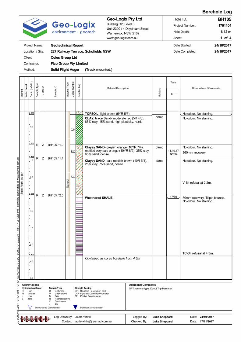
No odour. No staining.
No odour. No staining.
No odour. No staining.
No odour. No staining.
V-Bit refusal at 2.2m.
50mm recovery. Triple bounce.No odour. No staining.
TC-Bit refusal at 4.3m.
Sol
id F
light
Aug
er
TOPSOIL- light brown (5YR 5/6).
CLAY, trace Sand- moderate red (5R 4/6),85% clay, 15% sand, high plasticity, hard.
Clayey SAND- greyish orange (10YR 7/4),mottled very pale orange (10YR 8/2), 35% clay,65% sand, dense.
Clayey SAND- pale reddish brown (10R 5/4),25% clay, 75% sand, dense.
Weathered SHALE.
Continued as cored borehole from 4.3m
11,19,17N=36
17/50
CH
SC
SC
damp
damp
damp
Jar
Wat
er L
evel
Standard Penetration Test
Zero
Hydrocarbon Odour Sample TypeD SPTH High Disturbed
ContinuousCR Representative
Low BulkB PPUndisturbedMedium U DCPM Dynamic Cone Penetrometer
Pocket PenetrometerLZ
Strength Testing
Tests
Additional CommentsAbbreviationsSPT hammer type: Donut Trip Hammer.
Stabilised GroundwaterEncountered Groundwater
J
Observations / Comments
Dep
th (
mB
GL)
0.5
1.0
1.5
2.0
2.5
3.0
3.5
4.0
4.5
5.0
Geotechnical Report
1 of 4
Client:
Log Drawn By:
227 Railway Terrace, Schofields NSW
Solid Flight Auger (Truck mounted.)
6.12 m
Logged By:
1701104
Coles Group Ltd
Method:
Contractor:
Date:
24/10/2017
24/10/2017
Laurie White
Warriewood NSW 2102
Geo-Logix Pty LtdBuilding Q2, Level 3
www.geo-logix.com.au
Unit 2309 / 4 Daydream Street
17/11/2017
Borehole Log
Project Name:
24/10/2017
BH105
Location / Site:
Fico Group Pty Limited
Date Started:
Project Number:
Hole Depth:
Date Completed:
Sheet:
Hole ID.
Date:
Luke Sheppard
Luke SheppardChecked By:
Met
hod
GL
SC
HO
FIE
LDS
170
1104
BH
170
1104
SC
HO
FIE
LDS
GE
OT
EC
H.G
PJ
GL.
GD
T 1
7/1
1/17
2:
19:2
5 P
M -
dra
wn
by la
urie
whi
te a
t w
ww
.reu
ma
d.co
m.a
u
Material Description
SPT
Gra
phic
Log
US
CS
Sym
bol
Moi
stur
e
BH105 / 1.0
BH105 / 1.4
BH105 / 2.5
R
R
R
Sam
ple
ID
Sam
ple
Typ
e
0.100
1.000
1.400
2.500
4.300
Z
Z
Z
HC
Odo
ur
Nat
ural
Mat
eria
l Typ
e
360mm recovery.

thin shale with finesandstone laminations<1mm
coarser laminations<1mm
JT, 0°, CU, SO, CN, finerlaminations <1mm
coarser laminations<1mmJT, 0°, CU, SO, CN
FZ, 0°, PL, RO, CO
JT, 0°, CU, SO, CN
DefectSpacing
(mm)
NM
LC C
orin
g
SANDSTONE- light brownish grey (5YR 6/1).
SHALE / SANDSTONE- dark yellowish brown (10YR 4/2).
SANDSTONE- light brownish grey (5YR 6/1).
SANDSTONE- dark yellowish brown (10YR 4/2).
SANDSTONE- light brownish grey (5YR 6/1).
SANDSTONE- dark yellowish brown (10YR 4/2) and dark yellowish brown(10YR 4/2).Extremely Weathered 4.66-4.69m.
SHALE- dark yellowish brown (10YR 4/2).
SANDSTONE- light brownish grey (5YR 6/1).
Alternating Laminations of SHALE / SANDSTONE- dark yellowish brown(10YR 4/2).
SANDSTONE- light brownish grey (5YR 6/1).
SILTSTONE / SHALE & SANDSTONE- light brownish grey (5YR 6/1).
Continued as cored borehole from 4.3mRun11.2m
Low BulkB PP
Wat
er L
evel
Defect Description(Type, Inclination, Planarity,Roughness, Coating)20 60 20
060
020
00
Observations / Comments
www.geo-logix.com.au
Laurie White
US
CS
Sym
bol
Gra
phic
Log
[email protected] 17/11/2017
Borehole Log
Project Name:
24/10/2017
BH105
Location / Site:
Fico Group Pty Limited
Date:
Logged By: Luke Sheppard
Luke SheppardChecked By:Contact:
Warriewood NSW 2102
Geo-Logix Pty LtdBuilding Q2, Level 3
Date:
1701104
Coles Group Ltd
Method:
Client:
Date Started:
Log Drawn By:
227 Railway Terrace, Schofields NSW
UndisturbedMedium U DCPM
Geotechnical Report
Dynamic Cone PenetrometerPocket Penetrometer
Planar CleanMB VR Very RoughType Inclination RoughnessPlanarity
#° Degrees PLMechanical BreakCoating
Crushed SeamCSeamSMShear SurfaceSSShear ZoneSZ IR Irregular
CFZ S SlickensidedST SteppedFractured ZoneParting VNPT SO Smooth VeneerUN UndulatingJoint SNCurvedJT RO Rough StainedCU
Defect Descriptors
Coating
High
Notes SPT hammer type: Donut Trip Hammer.
Hole ID.
Date Completed:
Unit 2309 / 4 Daydream Street
Met
hod
Material Description
Dep
th (
mB
GL)
4.1
4.2
4.3
4.4
4.5
4.6
4.7
4.8
4.9
5.0
Solid Flight Auger (Truck mounted.)
6.12 m
Contractor:
24/10/2017
24/10/2017
Stabilised GroundwaterEncountered Groundwater
LZ Zero
CNStrength TestingHydrocarbon Odour Sample Type
D SPT Standard Penetration TestH Disturbed
Abbreviations
ContinuousCR Representative
Sheet:
Project Number:
Hole Depth:
Run
/ R
QD
%
2 of 4
GL
SC
HO
FIE
LDS
170
1104
CH
170
1104
SC
HO
FIE
LDS
GE
OT
EC
H.G
PJ
GL.
GD
T 1
7/1
1/17
2:
22:5
4 P
M -
dra
wn
by la
urie
whi
te a
t w
ww
.reu
ma
d.co
m.a
u
4.30
4.39
4.45
4.48
4.55
4.61
4.77
4.79
4.81
4.89
4.94
Nat
ural
Mat
eria
l Typ
e

JT, 0°, PL, RO, CN
JT, 0°, UN, RO, ST
JT, 0°, CU, RO, CN
JT, 5°, CU, SO, ST
DefectSpacing
(mm)
NM
LC C
orin
g
SANDSTONE- light brownish grey (5YR 6/1).
SANDSTONE- dark yellowish brown (10YR 4/2).
Extremely Weathered 5.18-5.22m.
SANDSTONE- light brownish grey (5YR 6/1).
Run11.2m
Run20.62m
Low BulkB PP
Wat
er L
evel
Defect Description(Type, Inclination, Planarity,Roughness, Coating)20 60 20
060
020
00
Observations / Comments
www.geo-logix.com.au
Laurie White
US
CS
Sym
bol
Gra
phic
Log
[email protected] 17/11/2017
Borehole Log
Project Name:
24/10/2017
BH105
Location / Site:
Fico Group Pty Limited
Date:
Logged By: Luke Sheppard
Luke SheppardChecked By:Contact:
Warriewood NSW 2102
Geo-Logix Pty LtdBuilding Q2, Level 3
Date:
1701104
Coles Group Ltd
Method:
Client:
Date Started:
Log Drawn By:
227 Railway Terrace, Schofields NSW
UndisturbedMedium U DCPM
Geotechnical Report
Dynamic Cone PenetrometerPocket Penetrometer
Planar CleanMB VR Very RoughType Inclination RoughnessPlanarity
#° Degrees PLMechanical BreakCoating
Crushed SeamCSeamSMShear SurfaceSSShear ZoneSZ IR Irregular
CFZ S SlickensidedST SteppedFractured ZoneParting VNPT SO Smooth VeneerUN UndulatingJoint SNCurvedJT RO Rough StainedCU
Defect Descriptors
Coating
High
Notes SPT hammer type: Donut Trip Hammer.
Hole ID.
Date Completed:
Unit 2309 / 4 Daydream Street
Met
hod
Material Description
Dep
th (
mB
GL)
5.1
5.2
5.3
5.4
5.5
5.6
5.7
5.8
5.9
6.0
Solid Flight Auger (Truck mounted.)
6.12 m
Contractor:
24/10/2017
24/10/2017
Stabilised GroundwaterEncountered Groundwater
LZ Zero
CNStrength TestingHydrocarbon Odour Sample Type
D SPT Standard Penetration TestH Disturbed
Abbreviations
ContinuousCR Representative
Sheet:
Project Number:
Hole Depth:
Run
/ R
QD
%
3 of 4
GL
SC
HO
FIE
LDS
170
1104
CH
170
1104
SC
HO
FIE
LDS
GE
OT
EC
H.G
PJ
GL.
GD
T 1
7/1
1/17
2:
22:5
4 P
M -
dra
wn
by la
urie
whi
te a
t w
ww
.reu
ma
d.co
m.a
u
5.01
5.12
5.20
Nat
ural
Mat
eria
l Typ
e

JT, -3°, IR, SO, STPT, 3°, UN, SO, ST
DefectSpacing
(mm)
NM
LC C
orin
g SANDSTONE- light brownish grey (5YR 6/1).(continued)
End of Hole at 6.12 m
Run20.62m
Low BulkB PP
Wat
er L
evel
Defect Description(Type, Inclination, Planarity,Roughness, Coating)20 60 20
060
020
00
Observations / Comments
www.geo-logix.com.au
Laurie White
US
CS
Sym
bol
Gra
phic
Log
[email protected] 17/11/2017
Borehole Log
Project Name:
24/10/2017
BH105
Location / Site:
Fico Group Pty Limited
Date:
Logged By: Luke Sheppard
Luke SheppardChecked By:Contact:
Warriewood NSW 2102
Geo-Logix Pty LtdBuilding Q2, Level 3
Date:
1701104
Coles Group Ltd
Method:
Client:
Date Started:
Log Drawn By:
227 Railway Terrace, Schofields NSW
UndisturbedMedium U DCPM
Geotechnical Report
Dynamic Cone PenetrometerPocket Penetrometer
Planar CleanMB VR Very RoughType Inclination RoughnessPlanarity
#° Degrees PLMechanical BreakCoating
Crushed SeamCSeamSMShear SurfaceSSShear ZoneSZ IR Irregular
CFZ S SlickensidedST SteppedFractured ZoneParting VNPT SO Smooth VeneerUN UndulatingJoint SNCurvedJT RO Rough StainedCU
Defect Descriptors
Coating
High
Notes SPT hammer type: Donut Trip Hammer.
Hole ID.
Date Completed:
Unit 2309 / 4 Daydream Street
Met
hod
Material Description
Dep
th (
mB
GL)
6.1
6.2
6.3
6.4
6.5
6.6
6.7
6.8
6.9
7.0
Solid Flight Auger (Truck mounted.)
6.12 m
Contractor:
24/10/2017
24/10/2017
Stabilised GroundwaterEncountered Groundwater
LZ Zero
CNStrength TestingHydrocarbon Odour Sample Type
D SPT Standard Penetration TestH Disturbed
Abbreviations
ContinuousCR Representative
Sheet:
Project Number:
Hole Depth:
Run
/ R
QD
%
4 of 4
GL
SC
HO
FIE
LDS
170
1104
CH
170
1104
SC
HO
FIE
LDS
GE
OT
EC
H.G
PJ
GL.
GD
T 1
7/1
1/17
2:
22:5
4 P
M -
dra
wn
by la
urie
whi
te a
t w
ww
.reu
ma
d.co
m.a
u
Nat
ural
Mat
eria
l Typ
e

No odour. No staining.
No odour. No staining.
V-Bit refusal at 1m.
No odour. No staining.
No odour. No staining.Moderate resistance.
Increasing to high resistance at3m. Drill rig lifting. Clay seams to100mm thick.
280 recovery. PP>500kPa.
Sol
id F
light
Aug
er
TOPSOIL- pale brown (5YR 5/2) and lightbrown (5YR 6/4).
CLAY, trace Sand- moderate red (5R 5/4) andmedium grey (N5), 85% clay, 15% sand, highplasticity, hard.
CLAY, trace Sand- moderate red (5R 5/4),mottled brownish grey (5YR 4/1), 85% clay,15% sand, high plasticity, hard.
Weathered SHALE- dark grey (N3).
End of Hole at 4.300 m
18,24,16N=40
25/65
CH
CH
damp
damp
Jar
Wat
er L
evel
Standard Penetration Test
Zero
Hydrocarbon Odour Sample TypeD SPTH High Disturbed
ContinuousCR Representative
Low BulkB PPUndisturbedMedium U DCPM Dynamic Cone Penetrometer
Pocket PenetrometerLZ
Strength Testing
Tests
Additional CommentsAbbreviationsSPT hammer type: Donut Trip Hammer.
Stabilised GroundwaterEncountered Groundwater
J
Observations / Comments
Dep
th (
mB
GL)
0.5
1.0
1.5
2.0
2.5
3.0
3.5
4.0
4.5
5.0
Geotechnical Report
1 of 1
Client:
Log Drawn By:
227 Railway Terrace, Schofields NSW
Solid Flight Auger (Truck mounted.)
4.30 m
Logged By:
1701104
Coles Group Ltd
Method:
Contractor:
Date:
12/10/2017
12/10/2017
Laurie White
Warriewood NSW 2102
Geo-Logix Pty LtdBuilding Q2, Level 3
www.geo-logix.com.au
Unit 2309 / 4 Daydream Street
17/11/2017
Borehole Log
Project Name:
12/10/2017
BH106
Location / Site:
Fico Group Pty Limited
Date Started:
Project Number:
Hole Depth:
Date Completed:
Sheet:
Hole ID.
Date:
Luke Sheppard
Luke SheppardChecked By:
Met
hod
GL
SC
HO
FIE
LDS
170
1104
BH
170
1104
SC
HO
FIE
LDS
GE
OT
EC
H.G
PJ
GL.
GD
T 1
7/1
1/17
2:
19:2
8 P
M -
dra
wn
by la
urie
whi
te a
t w
ww
.reu
ma
d.co
m.a
u
Material Description
SPT
Gra
phic
Log
US
CS
Sym
bol
Moi
stur
e
BH106 /0.5-0.9
BH106 / 1.0
BH106 / 2.5
U
R
R
Sam
ple
ID
Sam
ple
Typ
e
0.100
1.000
1.800
Z
Z
Z
HC
Odo
ur
Nat
ural
Mat
eria
l Typ
e
380mm recovery.
65mm rocovery.

No odour. No staining.
No odour. No staining.
No odour. No staining.
No odour. No staining.
V-Bit refusal at 2.9m.
No odour. No staining.Wet sample, water added.Moderate resistance in weatheredshale (more due to clogging thanthe hardeness).No need to lift rig.
Sol
id F
light
Aug
er
TOPSOIL- light brown (5YR 6/4).
Sandy CLAY- light brown (5YR 6/4), mottledstrong brown (5YR 4/6), 60% clay, 40% sand,sandy clay with balls of moderate red clay.
CLAY, trace Sand- very pale orange (10YR8/2), mottled dark yellowish orange (10YR 6/6),85% clay, 15% sand, high plasticity, very stiff.
Sandy CLAY- dull reddish brown (5YR 5/4),mottled strong brown (5YR 4/6), 55% clay, 45%sand, low plasticity, soft, very weathered shale.
SHALE- dull reddish brown (5YR 5/4).
3,14,19N=33
8,24,30/110
CL
CH
CL
damp
damp
damp
Jar
Wat
er L
evel
Standard Penetration Test
Zero
Hydrocarbon Odour Sample TypeD SPTH High Disturbed
ContinuousCR Representative
Low BulkB PPUndisturbedMedium U DCPM Dynamic Cone Penetrometer
Pocket PenetrometerLZ
Strength Testing
Tests
Additional CommentsAbbreviationsSPT hammer type: Donut Trip Hammer.
Stabilised GroundwaterEncountered Groundwater
J
Observations / Comments
Dep
th (
mB
GL)
0.5
1.0
1.5
2.0
2.5
3.0
3.5
4.0
4.5
5.0
Geotechnical Report
1 of 2
Client:
Log Drawn By:
227 Railway Terrace, Schofields NSW
Solid Flight Auger (Truck mounted.)
7.50 m
Logged By:
1701104
Coles Group Ltd
Method:
Contractor:
Date:
24/10/2017
24/10/2017
Laurie White
Warriewood NSW 2102
Geo-Logix Pty LtdBuilding Q2, Level 3
www.geo-logix.com.au
Unit 2309 / 4 Daydream Street
17/11/2017
Borehole Log
Project Name:
24/10/2017
BH107
Location / Site:
Fico Group Pty Limited
Date Started:
Project Number:
Hole Depth:
Date Completed:
Sheet:
Hole ID.
Date:
Luke Sheppard
Luke SheppardChecked By:
Met
hod
GL
SC
HO
FIE
LDS
170
1104
BH
170
1104
SC
HO
FIE
LDS
GE
OT
EC
H.G
PJ
GL.
GD
T 1
7/1
1/17
2:
19:3
1 P
M -
dra
wn
by la
urie
whi
te a
t w
ww
.reu
ma
d.co
m.a
u
Material Description
SPT
Gra
phic
Log
US
CS
Sym
bol
Moi
stur
e
BH107 / 1.0aBH107 / 1.0b
BH107 / 2.5aBH107 / 2.5b
BH107 / 4.5aBH107 / 4.5b
RR
RR
DD
Sam
ple
ID
Sam
ple
Typ
e
0.100
1.000
2.500
2.900
ZZ
ZZ
ZZ
HC
Odo
ur
Nat
ural
Mat
eria
l Typ
e
350mm recovery.
420mm recovery.
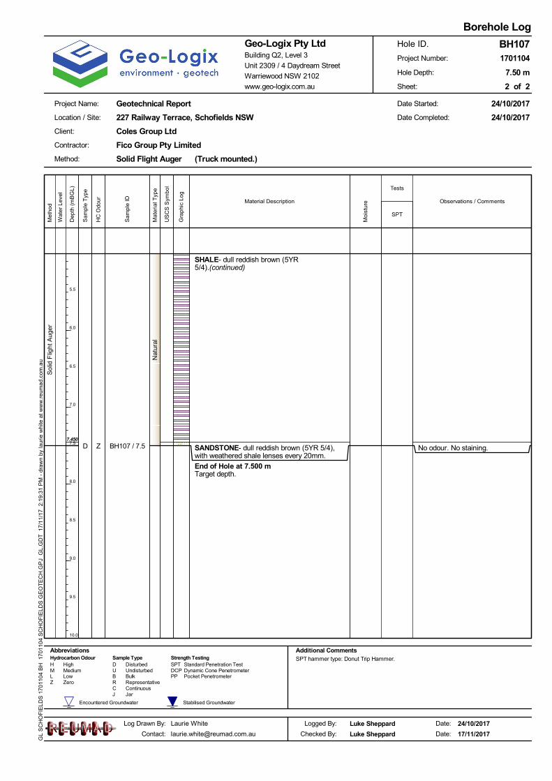
No odour. No staining.
Sol
id F
light
Aug
er
SHALE- dull reddish brown (5YR5/4).(continued)
SANDSTONE- dull reddish brown (5YR 5/4),with weathered shale lenses every 20mm.
End of Hole at 7.500 mTarget depth.
Jar
Wat
er L
evel
Standard Penetration Test
Zero
Hydrocarbon Odour Sample TypeD SPTH High Disturbed
ContinuousCR Representative
Low BulkB PPUndisturbedMedium U DCPM Dynamic Cone Penetrometer
Pocket PenetrometerLZ
Strength Testing
Tests
Additional CommentsAbbreviationsSPT hammer type: Donut Trip Hammer.
Stabilised GroundwaterEncountered Groundwater
J
Observations / Comments
Dep
th (
mB
GL)
5.5
6.0
6.5
7.0
7.5
8.0
8.5
9.0
9.5
10.0
Geotechnical Report
2 of 2
Client:
Log Drawn By:
227 Railway Terrace, Schofields NSW
Solid Flight Auger (Truck mounted.)
7.50 m
Logged By:
1701104
Coles Group Ltd
Method:
Contractor:
Date:
24/10/2017
24/10/2017
Laurie White
Warriewood NSW 2102
Geo-Logix Pty LtdBuilding Q2, Level 3
www.geo-logix.com.au
Unit 2309 / 4 Daydream Street
17/11/2017
Borehole Log
Project Name:
24/10/2017
BH107
Location / Site:
Fico Group Pty Limited
Date Started:
Project Number:
Hole Depth:
Date Completed:
Sheet:
Hole ID.
Date:
Luke Sheppard
Luke SheppardChecked By:
Met
hod
GL
SC
HO
FIE
LDS
170
1104
BH
170
1104
SC
HO
FIE
LDS
GE
OT
EC
H.G
PJ
GL.
GD
T 1
7/1
1/17
2:
19:3
1 P
M -
dra
wn
by la
urie
whi
te a
t w
ww
.reu
ma
d.co
m.a
u
Material Description
SPT
Gra
phic
Log
US
CS
Sym
bol
Moi
stur
e
BH107 / 7.5D
Sam
ple
ID
Sam
ple
Typ
e
7.450
Z
HC
Odo
ur
Nat
ural
Mat
eria
l Typ
e

No odour. No staining.
No odour. No staining.
350mm recovery.No odour. No staining.
No odour. No staining.
V-Bit refusal at 1.7m.
Sol
id F
light
Aug
er
TOPSOIL- pale brown (5YR 5/2) and lightbrown (5YR 6/4).
CLAY, trace Sand- light grey (N7), mottledmoderate reddish brown (10R 4/6), 85% clay,15% sand, high plasticity, very soft.
Clayey SAND- moderate red (5R 5/4), mottledlight grey (N7), 35% clay, 65% sand, loose.
Weathered SHALE- mottled dark grey (N3).
End of Hole at 4.300 m
6,10,16N=26
25/105
CH
SC
damp
damp
Jar
Wat
er L
evel
Standard Penetration Test
Zero
Hydrocarbon Odour Sample TypeD SPTH High Disturbed
ContinuousCR Representative
Low BulkB PPUndisturbedMedium U DCPM Dynamic Cone Penetrometer
Pocket PenetrometerLZ
Strength Testing
Tests
Additional CommentsAbbreviationsSPT hammer type: Donut Trip Hammer.
Stabilised GroundwaterEncountered Groundwater
J
Observations / Comments
Dep
th (
mB
GL)
0.5
1.0
1.5
2.0
2.5
3.0
3.5
4.0
4.5
5.0
Geotechnical Report
1 of 1
Client:
Log Drawn By:
227 Railway Terrace, Schofields NSW
Solid Flight Auger (Truck mounted.)
4.30 m
Logged By:
1701104
Coles Group Ltd
Method:
Contractor:
Date:
13/10/2017
13/10/2017
Laurie White
Warriewood NSW 2102
Geo-Logix Pty LtdBuilding Q2, Level 3
www.geo-logix.com.au
Unit 2309 / 4 Daydream Street
17/11/2017
Borehole Log
Project Name:
13/10/2017
BH108
Location / Site:
Fico Group Pty Limited
Date Started:
Project Number:
Hole Depth:
Date Completed:
Sheet:
Hole ID.
Date:
Luke Sheppard
Luke SheppardChecked By:
Met
hod
GL
SC
HO
FIE
LDS
170
1104
BH
170
1104
SC
HO
FIE
LDS
GE
OT
EC
H.G
PJ
GL.
GD
T 1
7/1
1/17
2:
19:3
4 P
M -
dra
wn
by la
urie
whi
te a
t w
ww
.reu
ma
d.co
m.a
u
Material Description
SPT
Gra
phic
Log
US
CS
Sym
bol
Moi
stur
e
BH108 / 1.0
BH108 / 1.3
BH108 / 2.5BH108 / 2.6
R
R
RR
Sam
ple
ID
Sam
ple
Typ
e
0.100
1.250
2.550
Z
Z
ZZ
HC
Odo
ur
Nat
ural
Mat
eria
l Typ
e
105mm recovery.
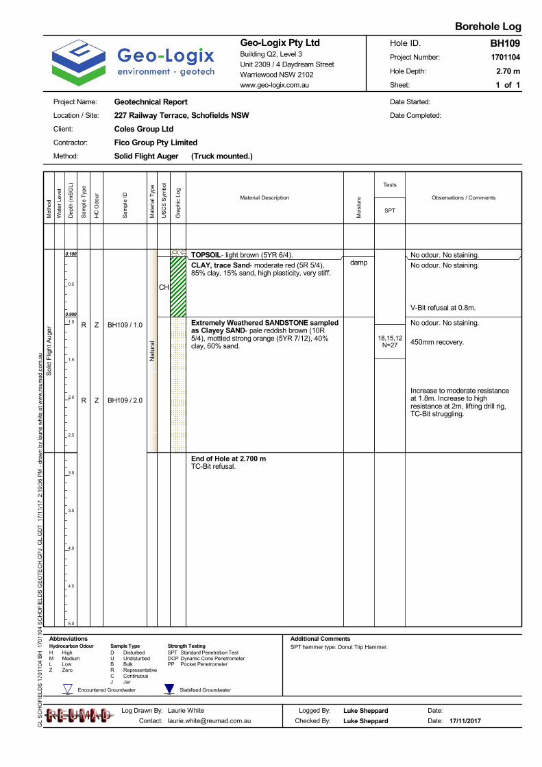
No odour. No staining.
No odour. No staining.
V-Bit refusal at 0.8m.
No odour. No staining.
Increase to moderate resistanceat 1.8m. Increase to highresistance at 2m, lifting drill rig,TC-Bit struggling.
Sol
id F
light
Aug
er
TOPSOIL- light brown (5YR 6/4).
CLAY, trace Sand- moderate red (5R 5/4),85% clay, 15% sand, high plasticity, very stiff.
Extremely Weathered SANDSTONE sampledas Clayey SAND- pale reddish brown (10R5/4), mottled strong orange (5YR 7/12), 40%clay, 60% sand.
End of Hole at 2.700 mTC-Bit refusal.
18,15,12N=27
CH
damp
Jar
Wat
er L
evel
Standard Penetration Test
Zero
Hydrocarbon Odour Sample TypeD SPTH High Disturbed
ContinuousCR Representative
Low BulkB PPUndisturbedMedium U DCPM Dynamic Cone Penetrometer
Pocket PenetrometerLZ
Strength Testing
Tests
Additional CommentsAbbreviationsSPT hammer type: Donut Trip Hammer.
Stabilised GroundwaterEncountered Groundwater
J
Observations / Comments
Dep
th (
mB
GL)
0.5
1.0
1.5
2.0
2.5
3.0
3.5
4.0
4.5
5.0
Geotechnical Report
1 of 1
Client:
Log Drawn By:
227 Railway Terrace, Schofields NSW
Solid Flight Auger (Truck mounted.)
2.70 m
Logged By:
1701104
Coles Group Ltd
Method:
Contractor:
Date:Laurie White
Warriewood NSW 2102
Geo-Logix Pty LtdBuilding Q2, Level 3
www.geo-logix.com.au
Unit 2309 / 4 Daydream Street
17/11/2017
Borehole Log
Project Name:
BH109
Location / Site:
Fico Group Pty Limited
Date Started:
Project Number:
Hole Depth:
Date Completed:
Sheet:
Hole ID.
Date:
Luke Sheppard
Luke SheppardChecked By:
Met
hod
GL
SC
HO
FIE
LDS
170
1104
BH
170
1104
SC
HO
FIE
LDS
GE
OT
EC
H.G
PJ
GL.
GD
T 1
7/1
1/17
2:
19:3
6 P
M -
dra
wn
by la
urie
whi
te a
t w
ww
.reu
ma
d.co
m.a
u
Material Description
SPT
Gra
phic
Log
US
CS
Sym
bol
Moi
stur
e
BH109 / 1.0
BH109 / 2.0
R
R
Sam
ple
ID
Sam
ple
Typ
e
0.100
0.900
Z
Z
HC
Odo
ur
Nat
ural
Mat
eria
l Typ
e
450mm recovery.
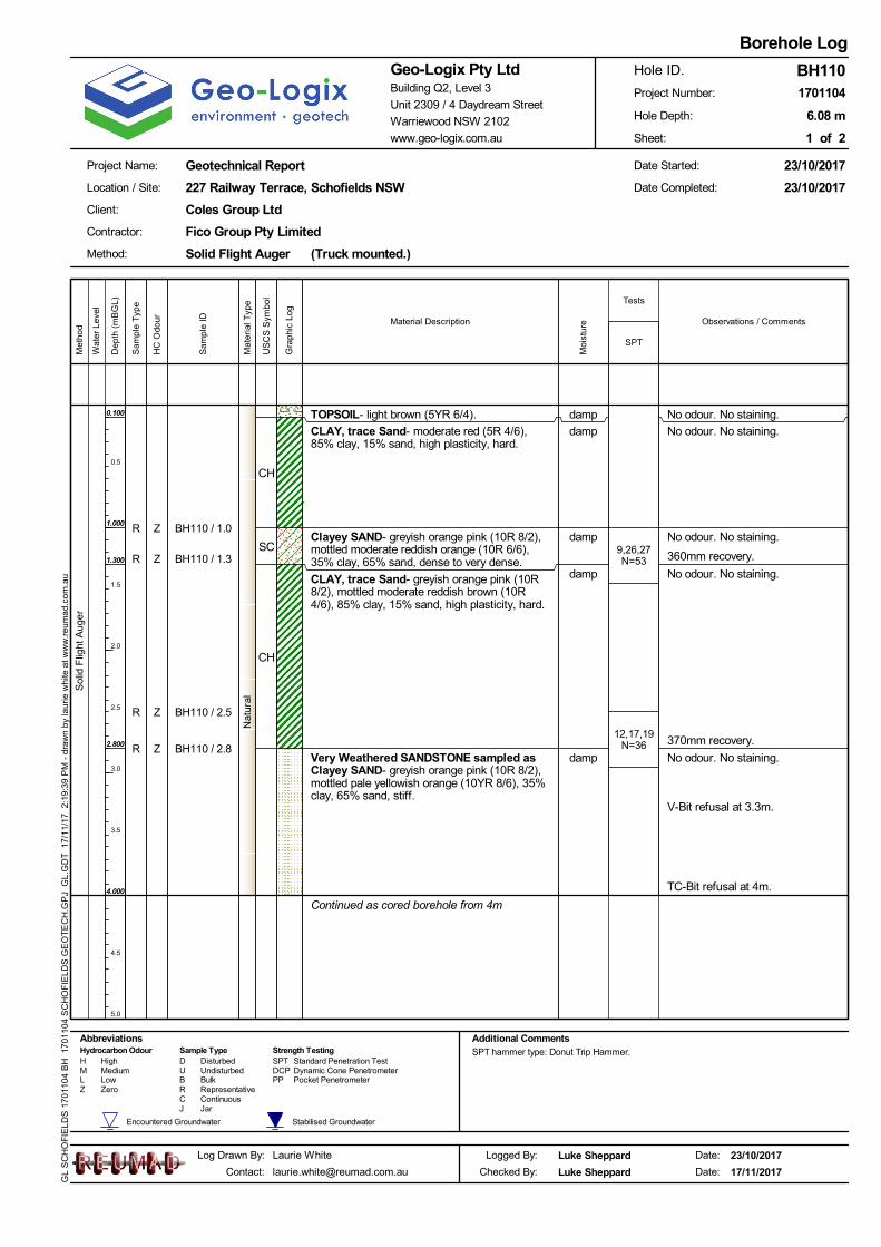
No odour. No staining.
No odour. No staining.
No odour. No staining.
No odour. No staining.
No odour. No staining.
V-Bit refusal at 3.3m.
TC-Bit refusal at 4m.
Sol
id F
light
Aug
er
TOPSOIL- light brown (5YR 6/4).
CLAY, trace Sand- moderate red (5R 4/6),85% clay, 15% sand, high plasticity, hard.
Clayey SAND- greyish orange pink (10R 8/2),mottled moderate reddish orange (10R 6/6),35% clay, 65% sand, dense to very dense.
CLAY, trace Sand- greyish orange pink (10R8/2), mottled moderate reddish brown (10R4/6), 85% clay, 15% sand, high plasticity, hard.
Very Weathered SANDSTONE sampled asClayey SAND- greyish orange pink (10R 8/2),mottled pale yellowish orange (10YR 8/6), 35%clay, 65% sand, stiff.
Continued as cored borehole from 4m
9,26,27N=53
12,17,19N=36
CH
SC
CH
damp
damp
damp
damp
damp
Jar
Wat
er L
evel
Standard Penetration Test
Zero
Hydrocarbon Odour Sample TypeD SPTH High Disturbed
ContinuousCR Representative
Low BulkB PPUndisturbedMedium U DCPM Dynamic Cone Penetrometer
Pocket PenetrometerLZ
Strength Testing
Tests
Additional CommentsAbbreviationsSPT hammer type: Donut Trip Hammer.
Stabilised GroundwaterEncountered Groundwater
J
Observations / Comments
Dep
th (
mB
GL)
0.5
1.0
1.5
2.0
2.5
3.0
3.5
4.0
4.5
5.0
Geotechnical Report
1 of 2
Client:
Log Drawn By:
227 Railway Terrace, Schofields NSW
Solid Flight Auger (Truck mounted.)
6.08 m
Logged By:
1701104
Coles Group Ltd
Method:
Contractor:
Date:
23/10/2017
23/10/2017
Laurie White
Warriewood NSW 2102
Geo-Logix Pty LtdBuilding Q2, Level 3
www.geo-logix.com.au
Unit 2309 / 4 Daydream Street
17/11/2017
Borehole Log
Project Name:
23/10/2017
BH110
Location / Site:
Fico Group Pty Limited
Date Started:
Project Number:
Hole Depth:
Date Completed:
Sheet:
Hole ID.
Date:
Luke Sheppard
Luke SheppardChecked By:
Met
hod
GL
SC
HO
FIE
LDS
170
1104
BH
170
1104
SC
HO
FIE
LDS
GE
OT
EC
H.G
PJ
GL.
GD
T 1
7/1
1/17
2:
19:3
9 P
M -
dra
wn
by la
urie
whi
te a
t w
ww
.reu
ma
d.co
m.a
u
Material Description
SPT
Gra
phic
Log
US
CS
Sym
bol
Moi
stur
e
BH110 / 1.0
BH110 / 1.3
BH110 / 2.5
BH110 / 2.8
R
R
R
R
Sam
ple
ID
Sam
ple
Typ
e
0.100
1.000
1.300
2.800
4.000
Z
Z
Z
Z
HC
Odo
ur
Nat
ural
Mat
eria
l Typ
e
360mm recovery.
370mm recovery.

JT, 5°, CU, RO, STJT, 5°, CU, RO, STPT, 5°, CU, RO, STPT, 5°, CU, RO, STFZ, 5°, CU, RO, STPT, 5°, CU, RO, STPT, -40°, UN, RO, STJT, 5°, IR, RO, STPT, -40°, UN, RO, STPT, 5°, IR, RO, STPT, 5°, IR, RO, STPT, 5°, CU, RO, ST
FZ, 5°, IR, RO, STJT, 80°, UN, RO, CNMBJT, 5°, IR, SO, STJT, 0°, V, RO, STJT, 0°, CU, RO, STJT, -20°, UN, SO, ST
MBFZ, 0°, CU, RO, STPT, 0°, IR, RO, STPT, 0°, IR, RO, STJT, -5°, CU, RO, CNJT, -5°, CU, RO, VNJT, -5°, CU, RO, STJT, -5°, CU, RO, ST
MB
<<
DefectSpacing
(mm)
NM
LC C
orin
g
SANDSTONE.Continued as cored borehole from 4m
End of Hole at 6.08 m
Run11.5m
Run20.58m
Low BulkB PP
Wat
er L
evel
Defect Description(Type, Inclination, Planarity,Roughness, Coating)20 60 20
060
020
00
Observations / Comments
www.geo-logix.com.au
Laurie White
US
CS
Sym
bol
Gra
phic
Log
[email protected] 17/11/2017
Borehole Log
Project Name:
23/10/2017
BH110
Location / Site:
Fico Group Pty Limited
Date:
Logged By: Luke Sheppard
Luke SheppardChecked By:Contact:
Warriewood NSW 2102
Geo-Logix Pty LtdBuilding Q2, Level 3
Date:
1701104
Coles Group Ltd
Method:
Client:
Date Started:
Log Drawn By:
227 Railway Terrace, Schofields NSW
UndisturbedMedium U DCPM
Geotechnical Report
Dynamic Cone PenetrometerPocket Penetrometer
Planar CleanMB VR Very RoughType Inclination RoughnessPlanarity
#° Degrees PLMechanical BreakCoating
Crushed SeamCSeamSMShear SurfaceSSShear ZoneSZ IR Irregular
CFZ S SlickensidedST SteppedFractured ZoneParting VNPT SO Smooth VeneerUN UndulatingJoint SNCurvedJT RO Rough StainedCU
Defect Descriptors
Coating
High
Notes SPT hammer type: Donut Trip Hammer.
Hole ID.
Date Completed:
Unit 2309 / 4 Daydream Street
Met
hod
Material Description
Dep
th (
mB
GL)
4.1
4.2
4.3
4.4
4.5
4.6
4.7
4.8
4.9
5.0
5.1
5.2
5.3
5.4
5.5
5.6
5.7
5.8
5.9
6.0
6.1
6.2
6.3
6.4
6.5
6.6
6.7
6.8
6.9
7.0
Solid Flight Auger (Truck mounted.)
6.08 m
Contractor:
23/10/2017
23/10/2017
Stabilised GroundwaterEncountered Groundwater
LZ Zero
CNStrength TestingHydrocarbon Odour Sample Type
D SPT Standard Penetration TestH Disturbed
Abbreviations
ContinuousCR Representative
Sheet:
Project Number:
Hole Depth:
Run
/ R
QD
%
2 of 2
GL
SC
HO
FIE
LDS
170
1104
CH
170
1104
SC
HO
FIE
LDS
GE
OT
EC
H.G
PJ
GL.
GD
T 1
7/1
1/17
2:
22:5
6 P
M -
dra
wn
by la
urie
whi
te a
t w
ww
.reu
ma
d.co
m.a
u
4.00
Mat
eria
l Typ
e
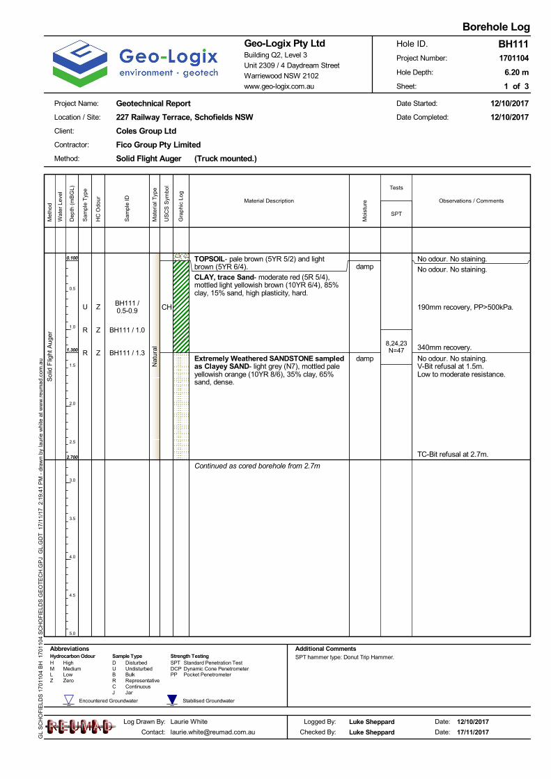
No odour. No staining.
No odour. No staining.
No odour. No staining.V-Bit refusal at 1.5m.Low to moderate resistance.
TC-Bit refusal at 2.7m.
190mm recovery, PP>500kPa.
Sol
id F
light
Aug
er
TOPSOIL- pale brown (5YR 5/2) and lightbrown (5YR 6/4).
CLAY, trace Sand- moderate red (5R 5/4),mottled light yellowish brown (10YR 6/4), 85%clay, 15% sand, high plasticity, hard.
Extremely Weathered SANDSTONE sampledas Clayey SAND- light grey (N7), mottled paleyellowish orange (10YR 8/6), 35% clay, 65%sand, dense.
Continued as cored borehole from 2.7m
8,24,23N=47
CH
damp
damp
Jar
Wat
er L
evel
Standard Penetration Test
Zero
Hydrocarbon Odour Sample TypeD SPTH High Disturbed
ContinuousCR Representative
Low BulkB PPUndisturbedMedium U DCPM Dynamic Cone Penetrometer
Pocket PenetrometerLZ
Strength Testing
Tests
Additional CommentsAbbreviationsSPT hammer type: Donut Trip Hammer.
Stabilised GroundwaterEncountered Groundwater
J
Observations / Comments
Dep
th (
mB
GL)
0.5
1.0
1.5
2.0
2.5
3.0
3.5
4.0
4.5
5.0
Geotechnical Report
1 of 3
Client:
Log Drawn By:
227 Railway Terrace, Schofields NSW
Solid Flight Auger (Truck mounted.)
6.20 m
Logged By:
1701104
Coles Group Ltd
Method:
Contractor:
Date:
12/10/2017
12/10/2017
Laurie White
Warriewood NSW 2102
Geo-Logix Pty LtdBuilding Q2, Level 3
www.geo-logix.com.au
Unit 2309 / 4 Daydream Street
17/11/2017
Borehole Log
Project Name:
12/10/2017
BH111
Location / Site:
Fico Group Pty Limited
Date Started:
Project Number:
Hole Depth:
Date Completed:
Sheet:
Hole ID.
Date:
Luke Sheppard
Luke SheppardChecked By:
Met
hod
GL
SC
HO
FIE
LDS
170
1104
BH
170
1104
SC
HO
FIE
LDS
GE
OT
EC
H.G
PJ
GL.
GD
T 1
7/1
1/17
2:
19:4
1 P
M -
dra
wn
by la
urie
whi
te a
t w
ww
.reu
ma
d.co
m.a
u
Material Description
SPT
Gra
phic
Log
US
CS
Sym
bol
Moi
stur
e
BH111 /0.5-0.9
BH111 / 1.0
BH111 / 1.3
U
R
R
Sam
ple
ID
Sam
ple
Typ
e
0.100
1.300
2.700
Z
Z
Z
HC
Odo
ur
Nat
ural
Mat
eria
l Typ
e
340mm recovery.
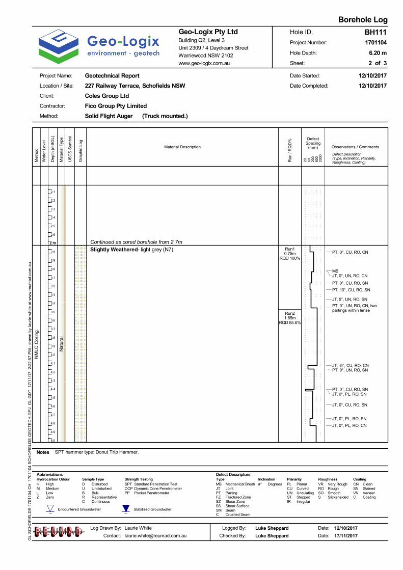
PT, 0°, CU, RO, CN
MBJT, 0°, UN, RO, CN
PT, 0°, CU, RO, SN
PT, 10°, CU, RO, SN
JT, 5°, UN, RO, SN
PT, 0°, UN, RO, CN, twopartings within lense
JT, -5°, CU, RO, CNPT, 0°, UN, RO, SN
PT, 0°, CU, RO, SNJT, 0°, PL, RO, SN
JT, 0°, CU, RO, SN
JT, 0°, PL, RO, SN
JT, 0°, PL, RO, CN
DefectSpacing
(mm)
NM
LC C
orin
g.
Slightly Weathered- light grey (N7).Continued as cored borehole from 2.7m
Run10.75m
RQD 100%
Run21.65m
RQD 85.6%
Low BulkB PP
Wat
er L
evel
Defect Description(Type, Inclination, Planarity,Roughness, Coating)20 60 20
060
020
00
Observations / Comments
www.geo-logix.com.au
Laurie White
US
CS
Sym
bol
Gra
phic
Log
[email protected] 17/11/2017
Borehole Log
Project Name:
12/10/2017
BH111
Location / Site:
Fico Group Pty Limited
Date:
Logged By: Luke Sheppard
Luke SheppardChecked By:Contact:
Warriewood NSW 2102
Geo-Logix Pty LtdBuilding Q2, Level 3
Date:
1701104
Coles Group Ltd
Method:
Client:
Date Started:
Log Drawn By:
227 Railway Terrace, Schofields NSW
UndisturbedMedium U DCPM
Geotechnical Report
Dynamic Cone PenetrometerPocket Penetrometer
Planar CleanMB VR Very RoughType Inclination RoughnessPlanarity
#° Degrees PLMechanical BreakCoating
Crushed SeamCSeamSMShear SurfaceSSShear ZoneSZ IR Irregular
CFZ S SlickensidedST SteppedFractured ZoneParting VNPT SO Smooth VeneerUN UndulatingJoint SNCurvedJT RO Rough StainedCU
Defect Descriptors
Coating
High
Notes SPT hammer type: Donut Trip Hammer.
Hole ID.
Date Completed:
Unit 2309 / 4 Daydream Street
Met
hod
Material Description
Dep
th (
mB
GL)
2.1
2.2
2.3
2.4
2.5
2.6
2.7
2.8
2.9
3.0
3.1
3.2
3.3
3.4
3.5
3.6
3.7
3.8
3.9
4.0
4.1
4.2
4.3
4.4
4.5
4.6
4.7
4.8
4.9
5.0
Solid Flight Auger (Truck mounted.)
6.20 m
Contractor:
12/10/2017
12/10/2017
Stabilised GroundwaterEncountered Groundwater
LZ Zero
CNStrength TestingHydrocarbon Odour Sample Type
D SPT Standard Penetration TestH Disturbed
Abbreviations
ContinuousCR Representative
Sheet:
Project Number:
Hole Depth:
Run
/ R
QD
%
2 of 3
GL
SC
HO
FIE
LDS
170
1104
CH
170
1104
SC
HO
FIE
LDS
GE
OT
EC
H.G
PJ
GL.
GD
T 1
7/1
1/17
2:
22:5
7 P
M -
dra
wn
by la
urie
whi
te a
t w
ww
.reu
ma
d.co
m.a
u
2.70
Nat
ural
Mat
eria
l Typ
e

JT, -5°, PR, SO, CL
MB
MB
MBMBJT, 20°, IR, SO, CLJT, 20°, IR, SO, CLPT, 40°, IR, RU, CL
DefectSpacing
(mm)
NM
LC C
orin
g.
Slightly Weathered- light grey (N7).(continued)
End of Hole at 6.20 m
Run31.1mRQD
85.45%
Low BulkB PP
Wat
er L
evel
Defect Description(Type, Inclination, Planarity,Roughness, Coating)20 60 20
060
020
00
Observations / Comments
www.geo-logix.com.au
Laurie White
US
CS
Sym
bol
Gra
phic
Log
[email protected] 17/11/2017
Borehole Log
Project Name:
12/10/2017
BH111
Location / Site:
Fico Group Pty Limited
Date:
Logged By: Luke Sheppard
Luke SheppardChecked By:Contact:
Warriewood NSW 2102
Geo-Logix Pty LtdBuilding Q2, Level 3
Date:
1701104
Coles Group Ltd
Method:
Client:
Date Started:
Log Drawn By:
227 Railway Terrace, Schofields NSW
UndisturbedMedium U DCPM
Geotechnical Report
Dynamic Cone PenetrometerPocket Penetrometer
Planar CleanMB VR Very RoughType Inclination RoughnessPlanarity
#° Degrees PLMechanical BreakCoating
Crushed SeamCSeamSMShear SurfaceSSShear ZoneSZ IR Irregular
CFZ S SlickensidedST SteppedFractured ZoneParting VNPT SO Smooth VeneerUN UndulatingJoint SNCurvedJT RO Rough StainedCU
Defect Descriptors
Coating
High
Notes SPT hammer type: Donut Trip Hammer.
Hole ID.
Date Completed:
Unit 2309 / 4 Daydream Street
Met
hod
Material Description
Dep
th (
mB
GL)
5.1
5.2
5.3
5.4
5.5
5.6
5.7
5.8
5.9
6.0
6.1
6.2
6.3
6.4
6.5
6.6
6.7
6.8
6.9
7.0
7.1
7.2
7.3
7.4
7.5
7.6
7.7
7.8
7.9
8.0
Solid Flight Auger (Truck mounted.)
6.20 m
Contractor:
12/10/2017
12/10/2017
Stabilised GroundwaterEncountered Groundwater
LZ Zero
CNStrength TestingHydrocarbon Odour Sample Type
D SPT Standard Penetration TestH Disturbed
Abbreviations
ContinuousCR Representative
Sheet:
Project Number:
Hole Depth:
Run
/ R
QD
%
3 of 3
GL
SC
HO
FIE
LDS
170
1104
CH
170
1104
SC
HO
FIE
LDS
GE
OT
EC
H.G
PJ
GL.
GD
T 1
7/1
1/17
2:
22:5
7 P
M -
dra
wn
by la
urie
whi
te a
t w
ww
.reu
ma
d.co
m.a
u
Nat
ural
Mat
eria
l Typ
e

No odour. No staining.
No odour. No staining.PP>500kPa.
No odour. No staining.PP=350-400kPa
No odour. No staining.
Exc
avat
ion
TOPSOIL- pale brown (5YR 5/2) and light brown (5YR6/4).
CLAY, trace Sand- moderate reddish orange (10R 6/6),85% clay, 15% sand, high plasticity, hard.
CLAY, trace Sand- greyish pink (5R 8/2), 90% clay,10% sand, high plasticity, very stiff.
Weathered SHALE- moderate reddish brown (10R 4/6).
Terminated at 2.700 m
CH
CH
damp
damp
Jar
Wat
er L
evel
Standard Penetration Test
Zero
Hydrocarbon Odour Sample TypeD SPTH High Disturbed
ContinuousCR Representative
Low BulkB PPUndisturbedMedium U DCPM Dynamic Cone Penetrometer
Pocket PenetrometerLZ
Strength TestingAdditional CommentsAbbreviations
Stabilised GroundwaterEncountered Groundwater
J
Observations / Comments
Dep
th (
mB
GL)
0.5
1.0
1.5
2.0
2.5
3.0
Geotechnical Report
1 of 1
Client:
Log Drawn By:
227 Railway Terrace, Schofields NSW
Excavation (450mm bucket)
2.70 m
Logged By:
1701104
Coles Group Ltd
Method:
Contractor:
Date:
12/10/2017
12/10/2017
Laurie White
Warriewood NSW 2102
Geo-Logix Pty LtdBuilding Q2, Level 3
www.geo-logix.com.au
Unit 2309 / 4 Daydream Street
17/11/2017
Test Pit Log
Project Name:
12/10/2017
TP1
Location / Site:
C & D Camilleri Excavations Pty Ltd
Date Started:
Project Number:
Hole Depth:
Date Completed:
Sheet:
Hole ID.
Date:
Ted Lilly
Luke SheppardChecked By:
Met
hod
GL
SC
HO
FIE
LDS
170
1104
BH
170
1104
SC
HO
FIE
LDS
GE
OT
EC
H.G
PJ
GL.
GD
T 1
7/1
1/17
2:
19:5
3 P
M -
dra
wn
by la
urie
whi
te a
t w
ww
.reu
ma
d.co
m.a
u
Material Description
Gra
phic
Log
US
CS
Sym
bol
Moi
stur
e
TP1 / 0.0-0.1U
Sam
ple
ID
Sam
ple
Typ
e
0.100
1.000
2.000
Z
HC
Odo
ur
Nat
ural
Mat
eria
l Typ
e

No odour. No staining.
No odour. No staining.
No odour. No staining.Exc
avat
ion
TOPSOIL- pale brown (5YR 5/2) and light brown (5YR6/4).
CLAY, trace Sand- moderate reddish orange (10R 6/6),85% clay, 15% sand, high plasticity, hard.
CLAY, trace Sand- greyish pink (5R 8/2), 90% clay,10% sand, high plasticity, hard.
Terminated at 1.500 m
CH
CH
damp
damp
Jar
Wat
er L
evel
Standard Penetration Test
Zero
Hydrocarbon Odour Sample TypeD SPTH High Disturbed
ContinuousCR Representative
Low BulkB PPUndisturbedMedium U DCPM Dynamic Cone Penetrometer
Pocket PenetrometerLZ
Strength TestingAdditional CommentsAbbreviationsACM on surface near test pit.
Stabilised GroundwaterEncountered Groundwater
J
Observations / Comments
Dep
th (
mB
GL)
0.5
1.0
1.5
2.0
2.5
3.0
Geotechnical Report
1 of 1
Client:
Log Drawn By:
227 Railway Terrace, Schofields NSW
Excavation (450mm bucket)
1.50 m
Logged By:
1701104
Coles Group Ltd
Method:
Contractor:
Date:
12/10/2017
12/10/2017
Laurie White
Warriewood NSW 2102
Geo-Logix Pty LtdBuilding Q2, Level 3
www.geo-logix.com.au
Unit 2309 / 4 Daydream Street
17/11/2017
Test Pit Log
Project Name:
12/10/2017
TP2
Location / Site:
C & D Camilleri Excavations Pty Ltd
Date Started:
Project Number:
Hole Depth:
Date Completed:
Sheet:
Hole ID.
Date:
Ted Lilly
Luke SheppardChecked By:
Met
hod
GL
SC
HO
FIE
LDS
170
1104
BH
170
1104
SC
HO
FIE
LDS
GE
OT
EC
H.G
PJ
GL.
GD
T 1
7/1
1/17
2:
19:5
5 P
M -
dra
wn
by la
urie
whi
te a
t w
ww
.reu
ma
d.co
m.a
u
Material Description
Gra
phic
Log
US
CS
Sym
bol
Moi
stur
e
TP2 / 0.0-0.1U
Sam
ple
ID
Sam
ple
Typ
e
0.100
0.800
Z
HC
Odo
ur
Nat
ural
Mat
eria
l Typ
e

No odour. No staining.
No odour. No staining.PP>500kPa.
No odour. No staining.
No odour. No staining.
Exc
avat
ion
TOPSOIL- pale brown (5YR 5/2) and light brown (5YR6/4).
CLAY, trace Sand- moderate reddish orange (10R 6/6),85% clay, 15% sand, high plasticity, hard.
CLAY, trace Sand- greyish pink (5R 8/2), 90% clay,10% sand, high plasticity, very stiff.
Weathered SHALE- moderate reddish brown (10R 4/6).
Terminated at 1.600 m
CH
CH
damp
damp
Jar
Wat
er L
evel
Standard Penetration Test
Zero
Hydrocarbon Odour Sample TypeD SPTH High Disturbed
ContinuousCR Representative
Low BulkB PPUndisturbedMedium U DCPM Dynamic Cone Penetrometer
Pocket PenetrometerLZ
Strength TestingAdditional CommentsAbbreviations
Stabilised GroundwaterEncountered Groundwater
J
Observations / Comments
Dep
th (
mB
GL)
0.5
1.0
1.5
2.0
2.5
3.0
Geotechnical Report
1 of 1
Client:
Log Drawn By:
227 Railway Terrace, Schofields NSW
Excavation (450mm bucket)
1.60 m
Logged By:
1701104
Coles Group Ltd
Method:
Contractor:
Date:
12/10/2017
12/10/2017
Laurie White
Warriewood NSW 2102
Geo-Logix Pty LtdBuilding Q2, Level 3
www.geo-logix.com.au
Unit 2309 / 4 Daydream Street
17/11/2017
Test Pit Log
Project Name:
12/10/2017
TP3
Location / Site:
C & D Camilleri Excavations Pty Ltd
Date Started:
Project Number:
Hole Depth:
Date Completed:
Sheet:
Hole ID.
Date:
Luke Sheppard
Luke SheppardChecked By:
Met
hod
GL
SC
HO
FIE
LDS
170
1104
BH
170
1104
SC
HO
FIE
LDS
GE
OT
EC
H.G
PJ
GL.
GD
T 1
7/1
1/17
2:
19:5
8 P
M -
dra
wn
by la
urie
whi
te a
t w
ww
.reu
ma
d.co
m.a
u
Material Description
Gra
phic
Log
US
CS
Sym
bol
Moi
stur
e
TP3 / 0.0-0.1U
Sam
ple
ID
Sam
ple
Typ
e
0.100
0.600
1.500
Z
HC
Odo
ur
Nat
ural
Mat
eria
l Typ
e
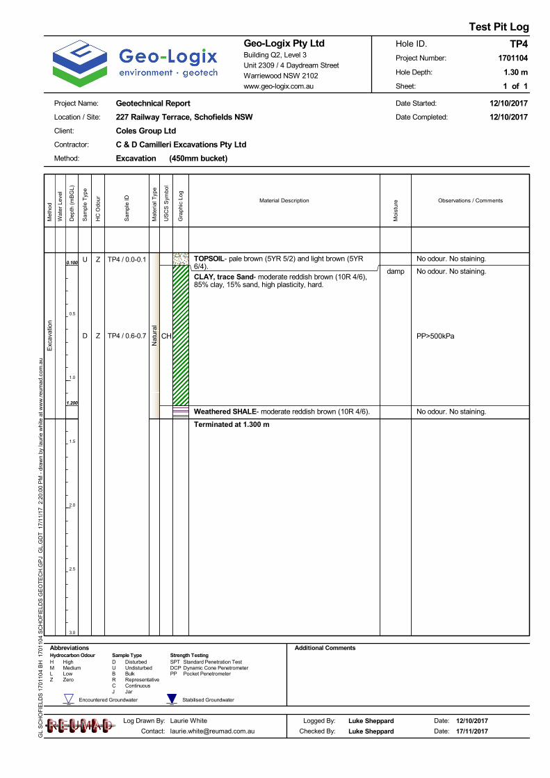
No odour. No staining.
No odour. No staining.
No odour. No staining.
PP>500kPa
Exc
avat
ion
TOPSOIL- pale brown (5YR 5/2) and light brown (5YR6/4).
CLAY, trace Sand- moderate reddish brown (10R 4/6),85% clay, 15% sand, high plasticity, hard.
Weathered SHALE- moderate reddish brown (10R 4/6).
Terminated at 1.300 m
CH
damp
Jar
Wat
er L
evel
Standard Penetration Test
Zero
Hydrocarbon Odour Sample TypeD SPTH High Disturbed
ContinuousCR Representative
Low BulkB PPUndisturbedMedium U DCPM Dynamic Cone Penetrometer
Pocket PenetrometerLZ
Strength TestingAdditional CommentsAbbreviations
Stabilised GroundwaterEncountered Groundwater
J
Observations / Comments
Dep
th (
mB
GL)
0.5
1.0
1.5
2.0
2.5
3.0
Geotechnical Report
1 of 1
Client:
Log Drawn By:
227 Railway Terrace, Schofields NSW
Excavation (450mm bucket)
1.30 m
Logged By:
1701104
Coles Group Ltd
Method:
Contractor:
Date:
12/10/2017
12/10/2017
Laurie White
Warriewood NSW 2102
Geo-Logix Pty LtdBuilding Q2, Level 3
www.geo-logix.com.au
Unit 2309 / 4 Daydream Street
17/11/2017
Test Pit Log
Project Name:
12/10/2017
TP4
Location / Site:
C & D Camilleri Excavations Pty Ltd
Date Started:
Project Number:
Hole Depth:
Date Completed:
Sheet:
Hole ID.
Date:
Luke Sheppard
Luke SheppardChecked By:
Met
hod
GL
SC
HO
FIE
LDS
170
1104
BH
170
1104
SC
HO
FIE
LDS
GE
OT
EC
H.G
PJ
GL.
GD
T 1
7/1
1/17
2:
20:0
0 P
M -
dra
wn
by la
urie
whi
te a
t w
ww
.reu
ma
d.co
m.a
u
Material Description
Gra
phic
Log
US
CS
Sym
bol
Moi
stur
e
TP4 / 0.0-0.1
TP4 / 0.6-0.7
U
D
Sam
ple
ID
Sam
ple
Typ
e
0.100
1.200
Z
Z
HC
Odo
ur
Nat
ural
Mat
eria
l Typ
e

No odour. No staining.
No odour. No staining.PP>500kPa.
No odour. No staining.PP=280kPa.
No odour. No staining.
Exc
avat
ion
TOPSOIL- pale brown (5YR 5/2) and light brown(5YR 6/4).
CLAY, trace Sand- moderate reddish brown (10R4/6), 85% clay, 15% sand, high plasticity, hard.
CLAY, trace Sand- moderate reddish brown (10R4/6), mottled greyish brown (5Y 3/2), 85% clay,15% sand, high plasticity, stiff.
Weathered SHALE- greyish brown (5Y 3/2).
Terminated at 1.700 m
CH
CH
DS1TS1
damp
damp
Jar
Wat
er L
evel
Standard Penetration Test
Zero
Hydrocarbon Odour Sample TypeD SPTH High Disturbed
ContinuousCR Representative
Low BulkB PPUndisturbedMedium U DCPM Dynamic Cone Penetrometer
Pocket PenetrometerLZ
Strength TestingAdditional CommentsAbbreviations
Stabilised GroundwaterEncountered Groundwater
J
Observations / Comments
Dep
th (
mB
GL)
0.5
1.0
1.5
2.0
2.5
3.0
Geotechnical Report
1 of 1
Client:
Log Drawn By:
227 Railway Terrace, Schofields NSW
Excavation (450mm bucket)
1.70 m
Logged By:
1701104
Coles Group Ltd
Method:
Contractor:
Date:
12/10/2017
12/10/2017
Laurie White
Warriewood NSW 2102
Geo-Logix Pty LtdBuilding Q2, Level 3
www.geo-logix.com.au
Unit 2309 / 4 Daydream Street
17/11/2017
Test Pit Log
Project Name:
12/10/2017
TP5
Location / Site:
C & D Camilleri Excavations Pty Ltd
Date Started:
Project Number:
Hole Depth:
Date Completed:
Sheet:
Hole ID.
Date:
Luke Sheppard
Luke SheppardChecked By:
Met
hod
GL
SC
HO
FIE
LDS
170
1104
BH
170
1104
SC
HO
FIE
LDS
GE
OT
EC
H.G
PJ
GL.
GD
T 1
7/1
1/17
2:
20:0
3 P
M -
dra
wn
by la
urie
whi
te a
t w
ww
.reu
ma
d.co
m.a
u
Material DescriptionG
raph
ic L
og
US
CS
Sym
bol
DU
P /
TR
IP
Moi
stur
e
TP5 / 0.0-0.1U
Sam
ple
ID
Sam
ple
Typ
e
0.100
0.900
1.600
Z
HC
Odo
ur
Nat
ural
Mat
eria
l Typ
e

No odour. No staining.
No odour. No staining.PP>500kPa.
No odour. No staining.PP=300kPa.
No odour. No staining.
Exc
avat
ion
TOPSOIL- light brown (5YR 5/6).
CLAY, trace Sand- moderate reddish brown (10R 4/6),85% clay, 15% sand, high plasticity, hard.
CLAY, trace Sand- moderate reddish brown (10R 4/6),mottled greyish brown (5Y 3/2), 85% clay, 15% sand, highplasticity, stiff.
Weathered SHALE- greyish brown (5Y 3/2).
Terminated at 1.300 m
CH
CH
damp
damp
Jar
Wat
er L
evel
Standard Penetration Test
Zero
Hydrocarbon Odour Sample TypeD SPTH High Disturbed
ContinuousCR Representative
Low BulkB PPUndisturbedMedium U DCPM Dynamic Cone Penetrometer
Pocket PenetrometerLZ
Strength TestingAdditional CommentsAbbreviations
Stabilised GroundwaterEncountered Groundwater
J
Observations / Comments
Dep
th (
mB
GL)
0.5
1.0
1.5
2.0
2.5
3.0
Geotechnical Report
1 of 1
Client:
Log Drawn By:
227 Railway Terrace, Schofields NSW
Excavation (450mm bucket)
1.30 m
Logged By:
1701104
Coles Group Ltd
Method:
Contractor:
Date:
12/10/2017
12/10/2017
Laurie White
Warriewood NSW 2102
Geo-Logix Pty LtdBuilding Q2, Level 3
www.geo-logix.com.au
Unit 2309 / 4 Daydream Street
17/11/2017
Test Pit Log
Project Name:
12/10/2017
TP6
Location / Site:
C & D Camilleri Excavations Pty Ltd
Date Started:
Project Number:
Hole Depth:
Date Completed:
Sheet:
Hole ID.
Date:
Luke Sheppard
Luke SheppardChecked By:
Met
hod
GL
SC
HO
FIE
LDS
170
1104
BH
170
1104
SC
HO
FIE
LDS
GE
OT
EC
H.G
PJ
GL.
GD
T 1
7/1
1/17
2:
20:0
5 P
M -
dra
wn
by la
urie
whi
te a
t w
ww
.reu
ma
d.co
m.a
u
Material Description
Gra
phic
Log
US
CS
Sym
bol
Moi
stur
e
TP6 / 0.0-0.2U
Sam
ple
ID
Sam
ple
Typ
e
0.200
0.600
1.200
Z
HC
Odo
ur
Nat
ural
Mat
eria
l Typ
e

No odour. No staining.
No odour. No staining.
No odour. No staining.PP>500kPa
No odour. No staining.PP>500kPa
Exc
avat
ion
TOPSOIL- pale brown (5YR 5/2).
Clayey SAND- pale brown (5YR 5/2), 35% clay, 65%sand, medium dense.
CLAY, trace Sand- moderate reddish brown (10R 4/6),85% clay, 15% sand, high plasticity, hard.
CLAY, trace Sand- moderate reddish brown (10R 4/6),mottled light yellowish brown (10YR 6/4), 85% clay, 15%sand, high plasticity, hard.
Terminated at 1.200 m
SC
CH
CH
damp
damp
damp
Jar
Wat
er L
evel
Standard Penetration Test
Zero
Hydrocarbon Odour Sample TypeD SPTH High Disturbed
ContinuousCR Representative
Low BulkB PPUndisturbedMedium U DCPM Dynamic Cone Penetrometer
Pocket PenetrometerLZ
Strength TestingAdditional CommentsAbbreviations
Stabilised GroundwaterEncountered Groundwater
J
Observations / Comments
Dep
th (
mB
GL)
0.5
1.0
1.5
2.0
2.5
3.0
Geotechnical Report
1 of 1
Client:
Log Drawn By:
227 Railway Terrace, Schofields NSW
Excavation (450mm bucket)
1.20 m
Logged By:
1701104
Coles Group Ltd
Method:
Contractor:
Date:
12/10/2017
12/10/2017
Laurie White
Warriewood NSW 2102
Geo-Logix Pty LtdBuilding Q2, Level 3
www.geo-logix.com.au
Unit 2309 / 4 Daydream Street
17/11/2017
Test Pit Log
Project Name:
12/10/2017
TP7
Location / Site:
C & D Camilleri Excavations Pty Ltd
Date Started:
Project Number:
Hole Depth:
Date Completed:
Sheet:
Hole ID.
Date:
Luke Sheppard
Luke SheppardChecked By:
Met
hod
GL
SC
HO
FIE
LDS
170
1104
BH
170
1104
SC
HO
FIE
LDS
GE
OT
EC
H.G
PJ
GL.
GD
T 1
7/1
1/17
2:
20:0
8 P
M -
dra
wn
by la
urie
whi
te a
t w
ww
.reu
ma
d.co
m.a
u
Material Description
Gra
phic
Log
US
CS
Sym
bol
Moi
stur
e
TP7 / 0.0-0.1U
Sam
ple
ID
Sam
ple
Typ
e
0.100
0.300
0.800
Z
HC
Odo
ur
Nat
ural
Mat
eria
l Typ
e

No odour. No staining.
No odour. No staining.
No odour. No staining.PP>500kPa.
No odour. No staining.
PP=450kPa
Exc
avat
ion
TOPSOIL- pale brown (5YR 5/2).
Clayey SAND- pale brown (5YR 5/2), 20% clay, 80%sand, medium dense.
CLAY, trace Sand- moderate reddish brown (10R 4/6),85% clay, 15% sand, high plasticity, hard.
Sandy CLAY- moderate reddish brown (10R 4/6),mottled light yellowish brown (10YR 6/4), 65% clay, 35%sand, high plasticity, hard.
Terminated at 1.400 m
SC
CH
CH
damp
damp
damp
Jar
Wat
er L
evel
Standard Penetration Test
Zero
Hydrocarbon Odour Sample TypeD SPTH High Disturbed
ContinuousCR Representative
Low BulkB PPUndisturbedMedium U DCPM Dynamic Cone Penetrometer
Pocket PenetrometerLZ
Strength TestingAdditional CommentsAbbreviations
Stabilised GroundwaterEncountered Groundwater
J
Observations / Comments
Dep
th (
mB
GL)
0.5
1.0
1.5
2.0
2.5
3.0
Geotechnical Report
1 of 1
Client:
Log Drawn By:
227 Railway Terrace, Schofields NSW
Excavation (450mm bucket)
1.40 m
Logged By:
1701104
Coles Group Ltd
Method:
Contractor:
Date:
12/10/2017
12/10/2017
Laurie White
Warriewood NSW 2102
Geo-Logix Pty LtdBuilding Q2, Level 3
www.geo-logix.com.au
Unit 2309 / 4 Daydream Street
17/11/2017
Test Pit Log
Project Name:
12/10/2017
TP8
Location / Site:
C & D Camilleri Excavations Pty Ltd
Date Started:
Project Number:
Hole Depth:
Date Completed:
Sheet:
Hole ID.
Date:
Luke Sheppard
Luke SheppardChecked By:
Met
hod
GL
SC
HO
FIE
LDS
170
1104
BH
170
1104
SC
HO
FIE
LDS
GE
OT
EC
H.G
PJ
GL.
GD
T 1
7/1
1/17
2:
20:1
0 P
M -
dra
wn
by la
urie
whi
te a
t w
ww
.reu
ma
d.co
m.a
u
Material Description
Gra
phic
Log
US
CS
Sym
bol
Moi
stur
e
TP8 / 0.0-0.1
TP8 / 0.6-0.7
U
D
Sam
ple
ID
Sam
ple
Typ
e
0.100
0.200
0.500
Z
Z
HC
Odo
ur
Nat
ural
Mat
eria
l Typ
e

No odour. No staining.
No odour. No staining.
No odour. No staining.
No odour. No staining.
Exc
avat
ion
TOPSOIL- light brown (5YR 6/4).
Clayey SAND- pale brown (5YR 5/2), 20% clay, 80%sand, medium dense.
CLAY, trace Sand- moderate reddish brown (10R 4/6),85% clay, 15% sand, high plasticity, hard.
Weathered SHALE- moderate reddish brown (10R 4/6).
Terminated at 1.300 m
SC
CH
damp
damp
Jar
Wat
er L
evel
Standard Penetration Test
Zero
Hydrocarbon Odour Sample TypeD SPTH High Disturbed
ContinuousCR Representative
Low BulkB PPUndisturbedMedium U DCPM Dynamic Cone Penetrometer
Pocket PenetrometerLZ
Strength TestingAdditional CommentsAbbreviations
Stabilised GroundwaterEncountered Groundwater
J
Observations / Comments
Dep
th (
mB
GL)
0.5
1.0
1.5
2.0
2.5
3.0
Geotechnical Report
1 of 1
Client:
Log Drawn By:
227 Railway Terrace, Schofields NSW
Excavation (450mm bucket)
1.30 m
Logged By:
1701104
Coles Group Ltd
Method:
Contractor:
Date:
12/10/2017
12/10/2017
Laurie White
Warriewood NSW 2102
Geo-Logix Pty LtdBuilding Q2, Level 3
www.geo-logix.com.au
Unit 2309 / 4 Daydream Street
17/11/2017
Test Pit Log
Project Name:
12/10/2017
TP9
Location / Site:
C & D Camilleri Excavations Pty Ltd
Date Started:
Project Number:
Hole Depth:
Date Completed:
Sheet:
Hole ID.
Date:
Luke Sheppard
Luke SheppardChecked By:
Met
hod
GL
SC
HO
FIE
LDS
170
1104
BH
170
1104
SC
HO
FIE
LDS
GE
OT
EC
H.G
PJ
GL.
GD
T 1
7/1
1/17
2:
20:1
3 P
M -
dra
wn
by la
urie
whi
te a
t w
ww
.reu
ma
d.co
m.a
u
Material Description
Gra
phic
Log
US
CS
Sym
bol
Moi
stur
e
TP9 / 0.0-0.1U
Sam
ple
ID
Sam
ple
Typ
e
0.100
0.300
1.200
Z
HC
Odo
ur
Nat
ural
Mat
eria
l Typ
e

No odour. No staining.
No odour. No staining.
No odour. No staining.
Exc
avat
ion
TOPSOIL- pale brown (5YR 5/2).
CLAY, trace Sand- moderate reddish brown (10R 4/6),mottled light yellowish brown (10YR 6/4), 85% clay, 15%sand, high plasticity, hard.
Weathered SHALE- moderate reddish brown (10R 4/6)and light yellowish brown (10YR 6/4).
Terminated at 1.200 m
CH
damp
Jar
Wat
er L
evel
Standard Penetration Test
Zero
Hydrocarbon Odour Sample TypeD SPTH High Disturbed
ContinuousCR Representative
Low BulkB PPUndisturbedMedium U DCPM Dynamic Cone Penetrometer
Pocket PenetrometerLZ
Strength TestingAdditional CommentsAbbreviations
Stabilised GroundwaterEncountered Groundwater
J
Observations / Comments
Dep
th (
mB
GL)
0.5
1.0
1.5
2.0
2.5
3.0
Geotechnical Report
1 of 1
Client:
Log Drawn By:
227 Railway Terrace, Schofields NSW
Excavation (450mm bucket)
1.20 m
Logged By:
1701104
Coles Group Ltd
Method:
Contractor:
Date:
12/10/2017
12/10/2017
Laurie White
Warriewood NSW 2102
Geo-Logix Pty LtdBuilding Q2, Level 3
www.geo-logix.com.au
Unit 2309 / 4 Daydream Street
17/11/2017
Test Pit Log
Project Name:
12/10/2017
TP10
Location / Site:
C & D Camilleri Excavations Pty Ltd
Date Started:
Project Number:
Hole Depth:
Date Completed:
Sheet:
Hole ID.
Date:
Luke Sheppard
Luke SheppardChecked By:
Met
hod
GL
SC
HO
FIE
LDS
170
1104
BH
170
1104
SC
HO
FIE
LDS
GE
OT
EC
H.G
PJ
GL.
GD
T 1
7/1
1/17
2:
20:1
5 P
M -
dra
wn
by la
urie
whi
te a
t w
ww
.reu
ma
d.co
m.a
u
Material Description
Gra
phic
Log
US
CS
Sym
bol
Moi
stur
e
TP10 / 0.0-0.1U
Sam
ple
ID
Sam
ple
Typ
e
0.100
1.100
Z
HC
Odo
ur
Nat
ural
Mat
eria
l Typ
e

No odour. No staining.
No odour. No staining.
No odour. No staining.
Exc
avat
ion
TOPSOIL- pale brown (5YR 5/2).
CLAY, trace Sand- moderate reddish brown (10R 4/6),mottled light yellowish brown (10YR 6/4), 85% clay, 15%sand, high plasticity, hard.
Weathered SHALE- light yellowish brown (10YR 6/4).
Terminated at 1.400 m
CH
damp
Jar
Wat
er L
evel
Standard Penetration Test
Zero
Hydrocarbon Odour Sample TypeD SPTH High Disturbed
ContinuousCR Representative
Low BulkB PPUndisturbedMedium U DCPM Dynamic Cone Penetrometer
Pocket PenetrometerLZ
Strength TestingAdditional CommentsAbbreviations
Stabilised GroundwaterEncountered Groundwater
J
Observations / Comments
Dep
th (
mB
GL)
0.5
1.0
1.5
2.0
2.5
3.0
Geotechnical Report
1 of 1
Client:
Log Drawn By:
227 Railway Terrace, Schofields NSW
Excavation (450mm bucket)
1.40 m
Logged By:
1701104
Coles Group Ltd
Method:
Contractor:
Date:
12/10/2017
12/10/2017
Laurie White
Warriewood NSW 2102
Geo-Logix Pty LtdBuilding Q2, Level 3
www.geo-logix.com.au
Unit 2309 / 4 Daydream Street
17/11/2017
Test Pit Log
Project Name:
12/10/2017
TP11
Location / Site:
C & D Camilleri Excavations Pty Ltd
Date Started:
Project Number:
Hole Depth:
Date Completed:
Sheet:
Hole ID.
Date:
Luke Sheppard
Luke SheppardChecked By:
Met
hod
GL
SC
HO
FIE
LDS
170
1104
BH
170
1104
SC
HO
FIE
LDS
GE
OT
EC
H.G
PJ
GL.
GD
T 1
7/1
1/17
2:
20:1
7 P
M -
dra
wn
by la
urie
whi
te a
t w
ww
.reu
ma
d.co
m.a
u
Material Description
Gra
phic
Log
US
CS
Sym
bol
Moi
stur
e
TP11 / 0.0-0.1U
Sam
ple
ID
Sam
ple
Typ
e
0.200
1.300
Z
HC
Odo
ur
Nat
ural
Mat
eria
l Typ
e

No odour. No staining.
No odour. No staining.PP>500kPa.
No odour. No staining.PP=450kPa.
No odour. No staining.
Exc
avat
ion
TOPSOIL- light brown (5YR 5/6).
CLAY, trace Sand- moderate reddish brown (10R 4/6),85% clay, 15% sand, high plasticity, hard.
CLAY, trace Sand- moderate reddish brown (10R 4/6),mottled greyish brown (5Y 3/2), 85% clay, 15% sand, highplasticity, hard.
Weathered SHALE- greyish brown (5Y 3/2).
Terminated at 1.300 m
CH
CH
damp
damp
Jar
Wat
er L
evel
Standard Penetration Test
Zero
Hydrocarbon Odour Sample TypeD SPTH High Disturbed
ContinuousCR Representative
Low BulkB PPUndisturbedMedium U DCPM Dynamic Cone Penetrometer
Pocket PenetrometerLZ
Strength TestingAdditional CommentsAbbreviations
Stabilised GroundwaterEncountered Groundwater
J
Observations / Comments
Dep
th (
mB
GL)
0.5
1.0
1.5
2.0
2.5
3.0
Geotechnical Report
1 of 1
Client:
Log Drawn By:
227 Railway Terrace, Schofields NSW
Excavation (450mm bucket)
1.30 m
Logged By:
1701104
Coles Group Ltd
Method:
Contractor:
Date:
12/10/2017
12/10/2017
Laurie White
Warriewood NSW 2102
Geo-Logix Pty LtdBuilding Q2, Level 3
www.geo-logix.com.au
Unit 2309 / 4 Daydream Street
17/11/2017
Test Pit Log
Project Name:
12/10/2017
TP12
Location / Site:
C & D Camilleri Excavations Pty Ltd
Date Started:
Project Number:
Hole Depth:
Date Completed:
Sheet:
Hole ID.
Date:
Luke Sheppard
Luke SheppardChecked By:
Met
hod
GL
SC
HO
FIE
LDS
170
1104
BH
170
1104
SC
HO
FIE
LDS
GE
OT
EC
H.G
PJ
GL.
GD
T 1
7/1
1/17
2:
20:2
0 P
M -
dra
wn
by la
urie
whi
te a
t w
ww
.reu
ma
d.co
m.a
u
Material Description
Gra
phic
Log
US
CS
Sym
bol
Moi
stur
e
TP12 / 0.0-0.1
TP12 / 0.8-0.9
U
D
Sam
ple
ID
Sam
ple
Typ
e
0.200
0.800
1.200
Z
Z
HC
Odo
ur
Nat
ural
Mat
eria
l Typ
e

No odour. No staining.
No odour. No staining.PP>500kPa
No odour. No staining.
No odour. No staining.
Exc
avat
ion
TOPSOIL- pale brown (5YR 5/2).
Sandy CLAY- moderate reddish brown (10R 4/6),mottled greyish orange (10YR 7/4), 65% clay, 35% sand,high plasticity, hard.
Clayey SAND- pale brown (5YR 5/2), 30% clay, 70%sand, high plasticity, medium dense.
Weathered SANDSTONE- moderate reddish brown(10R 4/6), mottled very light grey (N8).
Terminated at 1.100 m
CH
SC
damp
damp
Jar
Wat
er L
evel
Standard Penetration Test
Zero
Hydrocarbon Odour Sample TypeD SPTH High Disturbed
ContinuousCR Representative
Low BulkB PPUndisturbedMedium U DCPM Dynamic Cone Penetrometer
Pocket PenetrometerLZ
Strength TestingAdditional CommentsAbbreviations
Stabilised GroundwaterEncountered Groundwater
J
Observations / Comments
Dep
th (
mB
GL)
0.5
1.0
1.5
2.0
2.5
3.0
Geotechnical Report
1 of 1
Client:
Log Drawn By:
227 Railway Terrace, Schofields NSW
Excavation (450mm bucket)
1.10 m
Logged By:
1701104
Coles Group Ltd
Method:
Contractor:
Date:
12/10/2017
12/10/2017
Laurie White
Warriewood NSW 2102
Geo-Logix Pty LtdBuilding Q2, Level 3
www.geo-logix.com.au
Unit 2309 / 4 Daydream Street
17/11/2017
Test Pit Log
Project Name:
12/10/2017
TP13
Location / Site:
C & D Camilleri Excavations Pty Ltd
Date Started:
Project Number:
Hole Depth:
Date Completed:
Sheet:
Hole ID.
Date:
Luke Sheppard
Luke SheppardChecked By:
Met
hod
GL
SC
HO
FIE
LDS
170
1104
BH
170
1104
SC
HO
FIE
LDS
GE
OT
EC
H.G
PJ
GL.
GD
T 1
7/1
1/17
2:
20:2
2 P
M -
dra
wn
by la
urie
whi
te a
t w
ww
.reu
ma
d.co
m.a
u
Material Description
Gra
phic
Log
US
CS
Sym
bol
Moi
stur
e
TP13 / 0.0-0.1U
Sam
ple
ID
Sam
ple
Typ
e
0.100
0.800
1.000
Z
HC
Odo
ur
Nat
ural
Mat
eria
l Typ
e

No odour. No staining.
No odour. No staining.PP>500kPa.
No odour. No staining.PP>500kPa.
No odour. No staining.
Exc
avat
ion
TOPSOIL- light brown (5YR 5/6).
CLAY, trace Sand- greyish orange (10YR 7/4), 85%clay, 15% sand, high plasticity, hard.
CLAY, trace Sand- light yellowish brown (10YR 6/4),mottled moderate reddish brown (10R 4/6), 85% clay,15% sand, high plasticity, hard.
Weathered SHALE- greyish brown (5Y 3/2).
Terminated at 1.900 m
CH
CH
damp
damp
Jar
Wat
er L
evel
Standard Penetration Test
Zero
Hydrocarbon Odour Sample TypeD SPTH High Disturbed
ContinuousCR Representative
Low BulkB PPUndisturbedMedium U DCPM Dynamic Cone Penetrometer
Pocket PenetrometerLZ
Strength TestingAdditional CommentsAbbreviations
Stabilised GroundwaterEncountered Groundwater
J
Observations / Comments
Dep
th (
mB
GL)
0.5
1.0
1.5
2.0
2.5
3.0
Geotechnical Report
1 of 1
Client:
Log Drawn By:
227 Railway Terrace, Schofields NSW
Excavation (450mm bucket)
1.90 m
Logged By:
1701104
Coles Group Ltd
Method:
Contractor:
Date:
12/10/2017
12/10/2017
Laurie White
Warriewood NSW 2102
Geo-Logix Pty LtdBuilding Q2, Level 3
www.geo-logix.com.au
Unit 2309 / 4 Daydream Street
17/11/2017
Test Pit Log
Project Name:
12/10/2017
TP14
Location / Site:
C & D Camilleri Excavations Pty Ltd
Date Started:
Project Number:
Hole Depth:
Date Completed:
Sheet:
Hole ID.
Date:
Luke Sheppard
Luke SheppardChecked By:
Met
hod
GL
SC
HO
FIE
LDS
170
1104
BH
170
1104
SC
HO
FIE
LDS
GE
OT
EC
H.G
PJ
GL.
GD
T 1
7/1
1/17
2:
20:2
5 P
M -
dra
wn
by la
urie
whi
te a
t w
ww
.reu
ma
d.co
m.a
u
Material Description
Gra
phic
Log
US
CS
Sym
bol
Moi
stur
e
TP14 / 0.0-0.1U
Sam
ple
ID
Sam
ple
Typ
e
0.200
1.200
1.800
Z
HC
Odo
ur
Nat
ural
Mat
eria
l Typ
e

No odour. No staining.
No odour. No staining.PP>500kPa.
No odour. No staining.
Exc
avat
ion
TOPSOIL- pale brown (5YR 5/2).
Sandy CLAY- moderate reddish brown (10R 4/6), 65% clay,35% sand, high plasticity, hard.
Weathered SANDSTONE- moderate reddish brown (10R 4/6),mottled moderate orange pink (10R 7/4).
Terminated at 1.200 m
CH
damp
Jar
Wat
er L
evel
Standard Penetration Test
Zero
Hydrocarbon Odour Sample TypeD SPTH High Disturbed
ContinuousCR Representative
Low BulkB PPUndisturbedMedium U DCPM Dynamic Cone Penetrometer
Pocket PenetrometerLZ
Strength TestingAdditional CommentsAbbreviationsLocation off grid due to fence. No surface sample taken. TP15a 0.0-0.1 taken in gridlocation.
Stabilised GroundwaterEncountered Groundwater
J
Observations / Comments
Dep
th (
mB
GL)
0.5
1.0
1.5
2.0
2.5
3.0
Geotechnical Report
1 of 1
Client:
Log Drawn By:
227 Railway Terrace, Schofields NSW
Excavation (450mm bucket)
1.20 m
Logged By:
1701104
Coles Group Ltd
Method:
Contractor:
Date:
12/10/2017
12/10/2017
Laurie White
Warriewood NSW 2102
Geo-Logix Pty LtdBuilding Q2, Level 3
www.geo-logix.com.au
Unit 2309 / 4 Daydream Street
17/11/2017
Test Pit Log
Project Name:
12/10/2017
TP15
Location / Site:
C & D Camilleri Excavations Pty Ltd
Date Started:
Project Number:
Hole Depth:
Date Completed:
Sheet:
Hole ID.
Date:
Luke Sheppard
Luke SheppardChecked By:
Met
hod
GL
SC
HO
FIE
LDS
170
1104
BH
170
1104
SC
HO
FIE
LDS
GE
OT
EC
H.G
PJ
GL.
GD
T 1
7/1
1/17
2:
20:2
7 P
M -
dra
wn
by la
urie
whi
te a
t w
ww
.reu
ma
d.co
m.a
u
Material Description
Gra
phic
Log
US
CS
Sym
bol
Moi
stur
e
No Sample
Sam
ple
ID
0.200
1.100
Nat
ural
Mat
eria
l Typ
e

No odour. No staining.
No odour. No staining.PP>500kPa.
No odour. No staining.PP=400kPa.
No odour. No staining.
Exc
avat
ion
TOPSOIL- pale brown (5YR 5/2).
CLAY, trace Sand- moderate reddish brown (10R 4/6),85% clay, 15% sand, high plasticity, hard.
Sandy CLAY- pinkish grey (5YR 8/1), mottled darkyellowish orange (10YR 6/6), 65% clay, 35% sand, highplasticity, very stiff.
Weathered SHALE- pinkish grey (5YR 8/1), mottleddark yellowish orange (10YR 6/6).
Terminated at 2.200 m
CH
CH
damp
damp
Jar
Wat
er L
evel
Standard Penetration Test
Zero
Hydrocarbon Odour Sample TypeD SPTH High Disturbed
ContinuousCR Representative
Low BulkB PPUndisturbedMedium U DCPM Dynamic Cone Penetrometer
Pocket PenetrometerLZ
Strength TestingAdditional CommentsAbbreviations
Stabilised GroundwaterEncountered Groundwater
J
Observations / Comments
Dep
th (
mB
GL)
0.5
1.0
1.5
2.0
2.5
3.0
Geotechnical Report
1 of 1
Client:
Log Drawn By:
227 Railway Terrace, Schofields NSW
Excavation (450mm bucket)
2.20 m
Logged By:
1701104
Coles Group Ltd
Method:
Contractor:
Date:
12/10/2017
12/10/2017
Laurie White
Warriewood NSW 2102
Geo-Logix Pty LtdBuilding Q2, Level 3
www.geo-logix.com.au
Unit 2309 / 4 Daydream Street
17/11/2017
Test Pit Log
Project Name:
12/10/2017
TP16
Location / Site:
C & D Camilleri Excavations Pty Ltd
Date Started:
Project Number:
Hole Depth:
Date Completed:
Sheet:
Hole ID.
Date:
Luke Sheppard
Luke SheppardChecked By:
Met
hod
GL
SC
HO
FIE
LDS
170
1104
BH
170
1104
SC
HO
FIE
LDS
GE
OT
EC
H.G
PJ
GL.
GD
T 1
7/1
1/17
2:
20:3
0 P
M -
dra
wn
by la
urie
whi
te a
t w
ww
.reu
ma
d.co
m.a
u
Material Description
Gra
phic
Log
US
CS
Sym
bol
Moi
stur
e
TP16 / 0.0-0.1
TP16 / 0.6-0.7
U
D
Sam
ple
ID
Sam
ple
Typ
e
0.100
1.200
2.100
Z
Z
HC
Odo
ur
Nat
ural
Mat
eria
l Typ
e

No odour. No staining.
No odour. No staining.PP>500kPa.
Exc
avat
ion
TOPSOIL- pale brown (5YR 5/2).
CLAY, trace Sand- moderate reddish brown (10R 4/6),mottled light yellowish brown (10YR 6/4), 85% clay, 15%sand, high plasticity, hard.
Terminated at 0.500 m
CH
damp
Jar
Wat
er L
evel
Standard Penetration Test
Zero
Hydrocarbon Odour Sample TypeD SPTH High Disturbed
ContinuousCR Representative
Low BulkB PPUndisturbedMedium U DCPM Dynamic Cone Penetrometer
Pocket PenetrometerLZ
Strength TestingAdditional CommentsAbbreviations
Stabilised GroundwaterEncountered Groundwater
J
Observations / Comments
Dep
th (
mB
GL)
0.5
1.0
1.5
2.0
2.5
3.0
Geotechnical Report
1 of 1
Client:
Log Drawn By:
227 Railway Terrace, Schofields NSW
Excavation (450mm bucket)
0.50 m
Logged By:
1701104
Coles Group Ltd
Method:
Contractor:
Date:
12/10/2017
12/10/2017
Laurie White
Warriewood NSW 2102
Geo-Logix Pty LtdBuilding Q2, Level 3
www.geo-logix.com.au
Unit 2309 / 4 Daydream Street
17/11/2017
Test Pit Log
Project Name:
12/10/2017
TP17
Location / Site:
C & D Camilleri Excavations Pty Ltd
Date Started:
Project Number:
Hole Depth:
Date Completed:
Sheet:
Hole ID.
Date:
Luke Sheppard
Luke SheppardChecked By:
Met
hod
GL
SC
HO
FIE
LDS
170
1104
BH
170
1104
SC
HO
FIE
LDS
GE
OT
EC
H.G
PJ
GL.
GD
T 1
7/1
1/17
2:
20:3
2 P
M -
dra
wn
by la
urie
whi
te a
t w
ww
.reu
ma
d.co
m.a
u
Material Description
Gra
phic
Log
US
CS
Sym
bol
Moi
stur
e
CBRTP17 /0.2-0.5B
Sam
ple
ID
Sam
ple
Typ
e
0.200
Z
HC
Odo
ur
Nat
ural
Mat
eria
l Typ
e

No odour. No staining.
No odour. No staining.
Exc
avat
ion
TOPSOIL- pale brown (5YR 5/2).
CLAY, trace Sand- moderate reddish brown (10R 4/6),85% clay, 15% sand, high plasticity, hard.
Terminated at 0.500 m
CH
damp
Jar
Wat
er L
evel
Standard Penetration Test
Zero
Hydrocarbon Odour Sample TypeD SPTH High Disturbed
ContinuousCR Representative
Low BulkB PPUndisturbedMedium U DCPM Dynamic Cone Penetrometer
Pocket PenetrometerLZ
Strength TestingAdditional CommentsAbbreviationsMineral fibre pipe / tile fragments on surface near test pit.
Stabilised GroundwaterEncountered Groundwater
J
Observations / Comments
Dep
th (
mB
GL)
0.5
1.0
1.5
2.0
2.5
3.0
Geotechnical Report
1 of 1
Client:
Log Drawn By:
227 Railway Terrace, Schofields NSW
Excavation (450mm bucket)
0.50 m
Logged By:
1701104
Coles Group Ltd
Method:
Contractor:
Date:
12/10/2017
12/10/2017
Laurie White
Warriewood NSW 2102
Geo-Logix Pty LtdBuilding Q2, Level 3
www.geo-logix.com.au
Unit 2309 / 4 Daydream Street
17/11/2017
Test Pit Log
Project Name:
12/10/2017
TP18
Location / Site:
C & D Camilleri Excavations Pty Ltd
Date Started:
Project Number:
Hole Depth:
Date Completed:
Sheet:
Hole ID.
Date:
Luke Sheppard
Luke SheppardChecked By:
Met
hod
GL
SC
HO
FIE
LDS
170
1104
BH
170
1104
SC
HO
FIE
LDS
GE
OT
EC
H.G
PJ
GL.
GD
T 1
7/1
1/17
2:
20:3
4 P
M -
dra
wn
by la
urie
whi
te a
t w
ww
.reu
ma
d.co
m.a
u
Material Description
Gra
phic
Log
US
CS
Sym
bol
Moi
stur
e
CBRTP18 /0.3-0.5B
Sam
ple
ID
Sam
ple
Typ
e
0.100
Z
HC
Odo
ur
Nat
ural
Mat
eria
l Typ
e

No odour. No staining.
No odour. No staining.
Exc
avat
ion
TOPSOIL- pale brown (5YR 5/2).
CLAY, trace Sand- moderate reddish brown (10R 4/6),85% clay, 15% sand, medium plasticity, firm.
Terminated at 0.500 m
CL
damp
Jar
Wat
er L
evel
Standard Penetration Test
Zero
Hydrocarbon Odour Sample TypeD SPTH High Disturbed
ContinuousCR Representative
Low BulkB PPUndisturbedMedium U DCPM Dynamic Cone Penetrometer
Pocket PenetrometerLZ
Strength TestingAdditional CommentsAbbreviations
Stabilised GroundwaterEncountered Groundwater
J
Observations / Comments
Dep
th (
mB
GL)
0.5
1.0
1.5
2.0
2.5
3.0
Geotechnical Report
1 of 1
Client:
Log Drawn By:
227 Railway Terrace, Schofields NSW
Excavation (450mm bucket)
0.50 m
Logged By:
1701104
Coles Group Ltd
Method:
Contractor:
Date:
12/10/2017
12/10/2017
Laurie White
Warriewood NSW 2102
Geo-Logix Pty LtdBuilding Q2, Level 3
www.geo-logix.com.au
Unit 2309 / 4 Daydream Street
17/11/2017
Test Pit Log
Project Name:
12/10/2017
TP19
Location / Site:
C & D Camilleri Excavations Pty Ltd
Date Started:
Project Number:
Hole Depth:
Date Completed:
Sheet:
Hole ID.
Date:
Luke Sheppard
Luke SheppardChecked By:
Met
hod
GL
SC
HO
FIE
LDS
170
1104
BH
170
1104
SC
HO
FIE
LDS
GE
OT
EC
H.G
PJ
GL.
GD
T 1
7/1
1/17
2:
20:3
7 P
M -
dra
wn
by la
urie
whi
te a
t w
ww
.reu
ma
d.co
m.a
u
Material Description
Gra
phic
Log
US
CS
Sym
bol
Moi
stur
e
CBRTP19 /0.2-0.5B
Sam
ple
ID
Sam
ple
Typ
e
0.200
Z
HC
Odo
ur
Nat
ural
Mat
eria
l Typ
e

No odour. No staining.
No odour. No staining.
No odour. No staining.PP>500kPa.
No odour. No staining.
Exc
avat
ion
TOPSOIL- pale brown (5YR 5/2).
Silty SAND- pale brown (5YR 5/2), 30% silt, 70% sand,loose.
Sandy CLAY- moderate reddish brown (10R 4/6), 65%clay, 35% sand, high plasticity, hard.
Weathered SANDSTONE- light yellowish brown (10YR6/4).
Terminated at 1.300 m
SM
CH
damp
damp
Jar
Wat
er L
evel
Standard Penetration Test
Zero
Hydrocarbon Odour Sample TypeD SPTH High Disturbed
ContinuousCR Representative
Low BulkB PPUndisturbedMedium U DCPM Dynamic Cone Penetrometer
Pocket PenetrometerLZ
Strength TestingAdditional CommentsAbbreviations
Stabilised GroundwaterEncountered Groundwater
J
Observations / Comments
Dep
th (
mB
GL)
0.5
1.0
1.5
2.0
2.5
3.0
Geotechnical Report
1 of 1
Client:
Log Drawn By:
227 Railway Terrace, Schofields NSW
Excavation (450mm bucket)
1.30 m
Logged By:
1701104
Coles Group Ltd
Method:
Contractor:
Date:
12/10/2017
12/10/2017
Laurie White
Warriewood NSW 2102
Geo-Logix Pty LtdBuilding Q2, Level 3
www.geo-logix.com.au
Unit 2309 / 4 Daydream Street
17/11/2017
Test Pit Log
Project Name:
12/10/2017
TP20
Location / Site:
C & D Camilleri Excavations Pty Ltd
Date Started:
Project Number:
Hole Depth:
Date Completed:
Sheet:
Hole ID.
Date:
Luke Sheppard
Luke SheppardChecked By:
Met
hod
GL
SC
HO
FIE
LDS
170
1104
BH
170
1104
SC
HO
FIE
LDS
GE
OT
EC
H.G
PJ
GL.
GD
T 1
7/1
1/17
2:
20:3
9 P
M -
dra
wn
by la
urie
whi
te a
t w
ww
.reu
ma
d.co
m.a
u
Material Description
Gra
phic
Log
US
CS
Sym
bol
Moi
stur
e
CBRTP20 /0.2-0.5B
Sam
ple
ID
Sam
ple
Typ
e
0.100
0.300
1.200
Z
HC
Odo
ur
Nat
ural
Mat
eria
l Typ
e

No odour. No staining.
No odour. No staining.PP>500kPa.
Exc
avat
ion
TOPSOIL- pale brown (5YR 5/2).
CLAY, trace Sand- moderate reddish brown (10R 4/6), mottled light yellowishbrown (10YR 6/4), 85% clay, 15% sand, high plasticity, hard.
Terminated at 2.100 m
CH
damp
Jar
Wat
er L
evel
Standard Penetration Test
Zero
Hydrocarbon Odour Sample TypeD SPTH High Disturbed
ContinuousCR Representative
Low BulkB PPUndisturbedMedium U DCPM Dynamic Cone Penetrometer
Pocket PenetrometerLZ
Strength TestingAdditional CommentsAbbreviations
Stabilised GroundwaterEncountered Groundwater
J
Observations / Comments
Dep
th (
mB
GL)
0.5
1.0
1.5
2.0
2.5
3.0
Geotechnical Report
1 of 1
Client:
Log Drawn By:
227 Railway Terrace, Schofields NSW
Excavation (450mm bucket)
2.10 m
Logged By:
1701104
Coles Group Ltd
Method:
Contractor:
Date:
12/10/2017
12/10/2017
Laurie White
Warriewood NSW 2102
Geo-Logix Pty LtdBuilding Q2, Level 3
www.geo-logix.com.au
Unit 2309 / 4 Daydream Street
17/11/2017
Test Pit Log
Project Name:
12/10/2017
TP21
Location / Site:
C & D Camilleri Excavations Pty Ltd
Date Started:
Project Number:
Hole Depth:
Date Completed:
Sheet:
Hole ID.
Date:
Luke Sheppard
Luke SheppardChecked By:
Met
hod
GL
SC
HO
FIE
LDS
170
1104
BH
170
1104
SC
HO
FIE
LDS
GE
OT
EC
H.G
PJ
GL.
GD
T 1
7/1
1/17
2:
20:4
1 P
M -
dra
wn
by la
urie
whi
te a
t w
ww
.reu
ma
d.co
m.a
u
Material Description
Gra
phic
Log
US
CS
Sym
bol
Moi
stur
e
0.100
Nat
ural
Mat
eria
l Typ
e

ATTACHMENT C
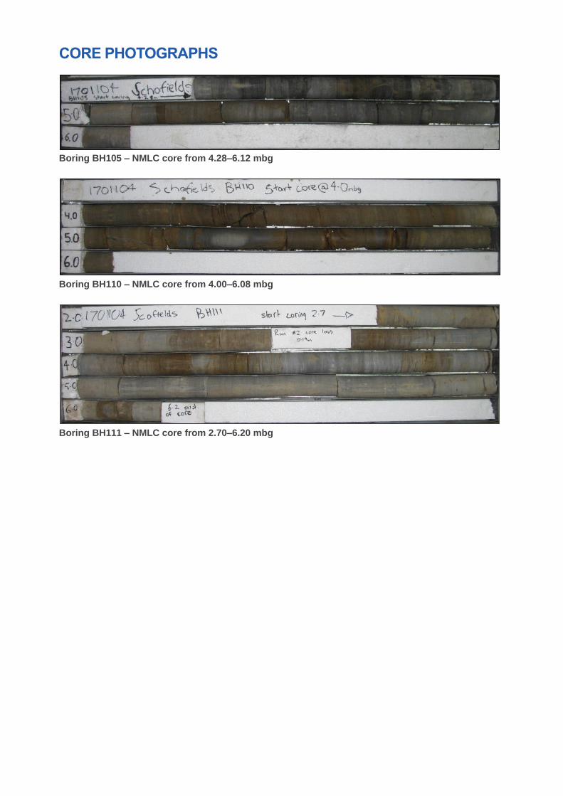
CORE PHOTOGRAPHS
Boring BH105 – NMLC core from 4.28–6.12 mbg
Boring BH110 – NMLC core from 4.00–6.08 mbg
Boring BH111 – NMLC core from 2.70–6.20 mbg

ATTACHMENT D
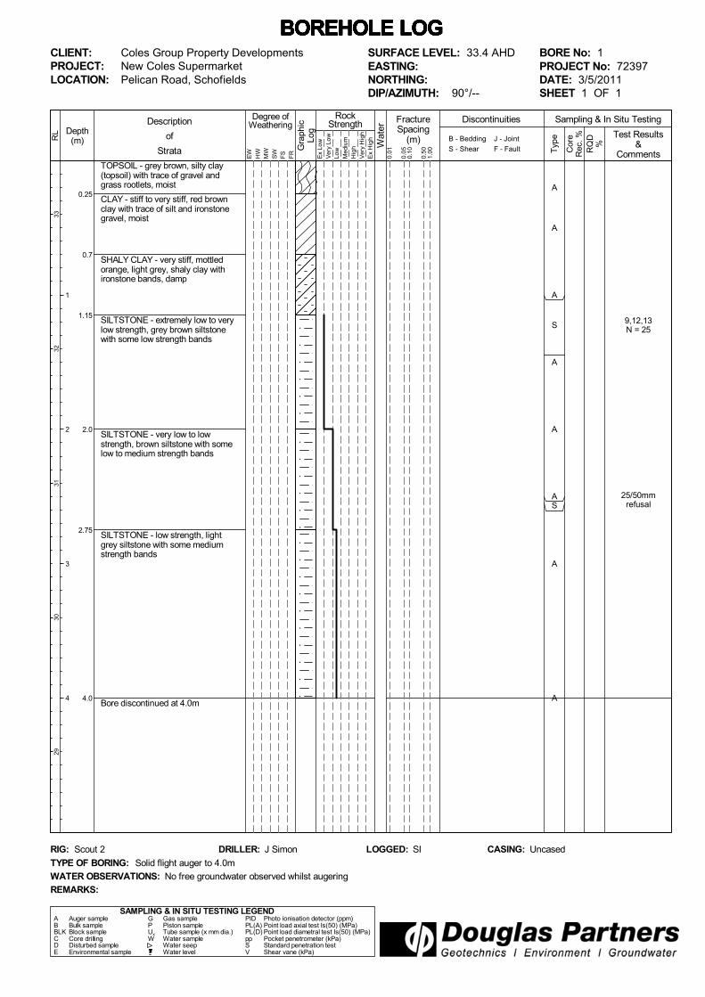
9,12,13N = 25
25/50mmrefusal
A
A
A
S
A
A
AS
A
A
TOPSOIL - grey brown, silty clay(topsoil) with trace of gravel andgrass rootlets, moist
CLAY - stiff to very stiff, red brownclay with trace of silt and ironstonegravel, moist
SHALY CLAY - very stiff, mottledorange, light grey, shaly clay withironstone bands, damp
SILTSTONE - extremely low to verylow strength, grey brown siltstonewith some low strength bands
SILTSTONE - very low to lowstrength, brown siltstone with somelow to medium strength bands
SILTSTONE - low strength, lightgrey siltstone with some mediumstrength bands
Bore discontinued at 4.0m
0.25
0.7
1.15
2.0
2.75
4.0
Wat
er
Degree ofWeathering
EW
HW
MW
SW
FS
FR
Description
of
Strata
FractureSpacing
(m)
0.01
Depth(m) B - Bedding
S - Shear
RockStrength
Typ
e
Sampling & In Situ Testing
Ex
Low
Ver
y Lo
wLo
w
Med
ium
Hig
h
Ver
y H
igh
Ex
Hig
h
0.10
0.50
1.00 R
QD
%
Cor
eR
ec. %
Gra
phic
Log
1
2
3
4
J - Joint
F - Fault
RL
3332
3130
29
Test Results&
Comments0.05
Discontinuities
BOREHOLE LOG BOREHOLE LOG BOREHOLE LOG BOREHOLE LOG BOREHOLE LOG BOREHOLE LOG BOREHOLE LOG CLIENT:PROJECT:LOCATION:
Coles Group Property DevelopmentsNew Coles SupermarketPelican Road, Schofields
SAMPLING & IN SITU TESTING LEGENDA Auger sample G Gas sample PID Photo ionisation detector (ppm)B Bulk sample P Piston sample PL(A) Point load axial test Is(50) (MPa)BLK Block sample Ux Tube sample (x mm dia.) PL(D) Point load diametral test Is(50) (MPa)C Core drilling W Water sample pp Pocket penetrometer (kPa)D Disturbed sample Water seep S Standard penetration testE Environmental sample Water level V Shear vane (kPa)
BORE No: 1PROJECT No: 72397DATE: 3/5/2011SHEET 1 OF 1
WATER OBSERVATIONS: No free groundwater observed whilst augering
TYPE OF BORING: Solid flight auger to 4.0m
RIG: Scout 2 DRILLER: J Simon
REMARKS:
LOGGED: SI CASING: Uncased
SURFACE LEVEL: 33.4 AHDEASTING:NORTHING:DIP/AZIMUTH: 90°/--

7,18,26N = 44
25/90mmrefusal
25/90mmrefusal
A
A
A
S
A
A
AS
A
AS
TOPSOIL - grey clay (topsoil) withtrace of silt, fine gravel and grassrootlets, moist
CLAY - red brown clay with trace ofironstone gravel, moist
SILTSTONE - extremely lowstrength, light grey and brownsiltstone with ironstone bands
SILTSTONE - very low to lowstrength, grey brown siltstone. Somelow strength bands
SILTSTONE - low strength, greybrown siltstone. Some mediumstrength bands
Bore discontinued at 4.09m
0.25
0.7
2.0
3.0
4.09
Wat
er
Degree ofWeathering
EW
HW
MW
SW
FS
FR
Description
of
Strata
FractureSpacing
(m)
0.01
Depth(m) B - Bedding
S - Shear
RockStrength
Typ
e
Sampling & In Situ Testing
Ex
Low
Ver
y Lo
wLo
w
Med
ium
Hig
h
Ver
y H
igh
Ex
Hig
h
0.10
0.50
1.00 R
QD
%
Cor
eR
ec. %
Gra
phic
Log
1
2
3
4
J - Joint
F - Fault
RL
3332
3130
29
Test Results&
Comments0.05
Discontinuities
BOREHOLE LOG BOREHOLE LOG BOREHOLE LOG BOREHOLE LOG BOREHOLE LOG BOREHOLE LOG BOREHOLE LOG CLIENT:PROJECT:LOCATION:
Coles Group Property DevelopmentsNew Coles SupermarketPelican Road, Schofields
SAMPLING & IN SITU TESTING LEGENDA Auger sample G Gas sample PID Photo ionisation detector (ppm)B Bulk sample P Piston sample PL(A) Point load axial test Is(50) (MPa)BLK Block sample Ux Tube sample (x mm dia.) PL(D) Point load diametral test Is(50) (MPa)C Core drilling W Water sample pp Pocket penetrometer (kPa)D Disturbed sample Water seep S Standard penetration testE Environmental sample Water level V Shear vane (kPa)
BORE No: 2PROJECT No: 72397DATE: 6/5/2011SHEET 1 OF 1
WATER OBSERVATIONS: No free groundwater observed whilst augering
TYPE OF BORING: Solid flight auger to 4.0m
RIG: Scout DRILLER: J Simon
REMARKS:
LOGGED: SI CASING: Uncased
SURFACE LEVEL: 33.1 AHDEASTING:NORTHING:DIP/AZIMUTH: 90°/--

5,15,24N = 39
25/70mmrefusal
A
A
A
S
A
A
AS
A
A
TOPSOIL - grey to grey brown, siltyclay (topsoil) with trace of fine graveland grass rootlets, moist
CLAY - stiff, red brown clay, slightlysilty, with trace of ironstone gravel,moist
SHALY CLAY - hard, mottledorange, light grey, shaly clay withironstone bands, damp
SILTSTONE - very low to lowstrength, grey brown siltstone withlow to medium strength bands
SILTSTONE - low strength, lightgrey siltstone with some mediumstrength bands
Bore discontinued at 4.0m
0.15
0.9
1.3
3.4
4.0
Wat
er
Degree ofWeathering
EW
HW
MW
SW
FS
FR
Description
of
Strata
FractureSpacing
(m)
0.01
Depth(m) B - Bedding
S - Shear
RockStrength
Typ
e
Sampling & In Situ Testing
Ex
Low
Ver
y Lo
wLo
w
Med
ium
Hig
h
Ver
y H
igh
Ex
Hig
h
0.10
0.50
1.00 R
QD
%
Cor
eR
ec. %
Gra
phic
Log
1
2
3
4
J - Joint
F - Fault
RL
3231
3029
28
Test Results&
Comments0.05
Discontinuities
BOREHOLE LOG BOREHOLE LOG BOREHOLE LOG BOREHOLE LOG BOREHOLE LOG BOREHOLE LOG BOREHOLE LOG CLIENT:PROJECT:LOCATION:
Coles Group Property DevelopmentsNew Coles SupermarketPelican Road, Schofields
SAMPLING & IN SITU TESTING LEGENDA Auger sample G Gas sample PID Photo ionisation detector (ppm)B Bulk sample P Piston sample PL(A) Point load axial test Is(50) (MPa)BLK Block sample Ux Tube sample (x mm dia.) PL(D) Point load diametral test Is(50) (MPa)C Core drilling W Water sample pp Pocket penetrometer (kPa)D Disturbed sample Water seep S Standard penetration testE Environmental sample Water level V Shear vane (kPa)
BORE No: 3PROJECT No: 72397DATE: 3/5/2011SHEET 1 OF 1
WATER OBSERVATIONS: No free groundwater observed whilst augering
TYPE OF BORING: Solid flight auger to 4.0m
RIG: Scout 2 DRILLER: J Simon
REMARKS:
LOGGED: SI CASING: Uncased
SURFACE LEVEL: 32.0 AHDEASTING:NORTHING:DIP/AZIMUTH: 90°/--

6,19,16N = 35
25/50mmrefusal
A
A
A
S
A
A
AS
A
A
SILTY CLAY - grey brown, silty claywith some fine gravel, moist
CLAY - red brown clay, slightly silty,with trace of ironstone gravel, moist
SHALY CLAY - hard, grey brownand light brown, shaly clay withironstone bands (possible extremelylow strength siltstone)
SILTSTONE - very low strength,grey to grey brown siltstone withsome low strength bands
SILTSTONE - low strength, greysiltstone with some medium strengthbands
Bore discontinued at 4.0m
0.3
0.7
1.4
3.0
4.0
Wat
er
Degree ofWeathering
EW
HW
MW
SW
FS
FR
Description
of
Strata
FractureSpacing
(m)
0.01
Depth(m) B - Bedding
S - Shear
RockStrength
Typ
e
Sampling & In Situ Testing
Ex
Low
Ver
y Lo
wLo
w
Med
ium
Hig
h
Ver
y H
igh
Ex
Hig
h
0.10
0.50
1.00 R
QD
%
Cor
eR
ec. %
Gra
phic
Log
1
2
3
4
J - Joint
F - Fault
RL
3130
2928
27
Test Results&
Comments0.05
Discontinuities
BOREHOLE LOG BOREHOLE LOG BOREHOLE LOG BOREHOLE LOG BOREHOLE LOG BOREHOLE LOG BOREHOLE LOG CLIENT:PROJECT:LOCATION:
Coles Group Property DevelopmentsNew Coles SupermarketPelican Road, Schofields
SAMPLING & IN SITU TESTING LEGENDA Auger sample G Gas sample PID Photo ionisation detector (ppm)B Bulk sample P Piston sample PL(A) Point load axial test Is(50) (MPa)BLK Block sample Ux Tube sample (x mm dia.) PL(D) Point load diametral test Is(50) (MPa)C Core drilling W Water sample pp Pocket penetrometer (kPa)D Disturbed sample Water seep S Standard penetration testE Environmental sample Water level V Shear vane (kPa)
BORE No: 4PROJECT No: 72397DATE: 6/5/2011SHEET 1 OF 1
WATER OBSERVATIONS: No free groundwater observed whilst augering
TYPE OF BORING: Solid flight auger to 4.0m
RIG: Scout 2 DRILLER: J Simon
REMARKS:
LOGGED: SI CASING: Uncased
SURFACE LEVEL: 31.7 AHDEASTING:NORTHING:DIP/AZIMUTH: 90°/--

1,5,8N = 13
25/80mmrefusal
A
A
A
S
A
A
AS
A
A
SILTY CLAY - grey to dark grey, siltyclay with some fine gravel, wet(possible filling)
SILTY CLAY - mottled orange redbrown and light grey, silty clay withtrace of ironstone gravel, moist
1.0m: becoming stiff silty clay
CLAY - firm, light brown clay withtrace of silt and ironstone gravel, wet
SILTSTONE - very low to lowstrength, light grey brown siltstone.Some low to medium strength bands
SILTSTONE - low to mediumstrength, light grey siltstone
Bore discontinued at 4.0m
0.3
1.5
2.25
3.35
4.0
Wat
er
Degree ofWeathering
EW
HW
MW
SW
FS
FR
Description
of
Strata
FractureSpacing
(m)
0.01
Depth(m) B - Bedding
S - Shear
RockStrength
Typ
e
Sampling & In Situ Testing
Ex
Low
Ver
y Lo
wLo
w
Med
ium
Hig
h
Ver
y H
igh
Ex
Hig
h
0.10
0.50
1.00 R
QD
%
Cor
eR
ec. %
Gra
phic
Log
1
2
3
4
J - Joint
F - Fault
RL
3029
2827
26
Test Results&
Comments0.05
Discontinuities
BOREHOLE LOG BOREHOLE LOG BOREHOLE LOG BOREHOLE LOG BOREHOLE LOG BOREHOLE LOG BOREHOLE LOG CLIENT:PROJECT:LOCATION:
Coles Group Property DevelopmentsNew Coles SupermarketPelican Road, Schofields
SAMPLING & IN SITU TESTING LEGENDA Auger sample G Gas sample PID Photo ionisation detector (ppm)B Bulk sample P Piston sample PL(A) Point load axial test Is(50) (MPa)BLK Block sample Ux Tube sample (x mm dia.) PL(D) Point load diametral test Is(50) (MPa)C Core drilling W Water sample pp Pocket penetrometer (kPa)D Disturbed sample Water seep S Standard penetration testE Environmental sample Water level V Shear vane (kPa)
BORE No: 5PROJECT No: 72397DATE: 6/5/2011SHEET 1 OF 1
WATER OBSERVATIONS: Free groundwater observed at 0.5m whilst augering
TYPE OF BORING: Solid flight auger to 4.0m
RIG: Scout 2 DRILLER: J Simon
REMARKS:
LOGGED: SI CASING: Uncased
SURFACE LEVEL: 30.6 AHDEASTING:NORTHING:DIP/AZIMUTH: 90°/--
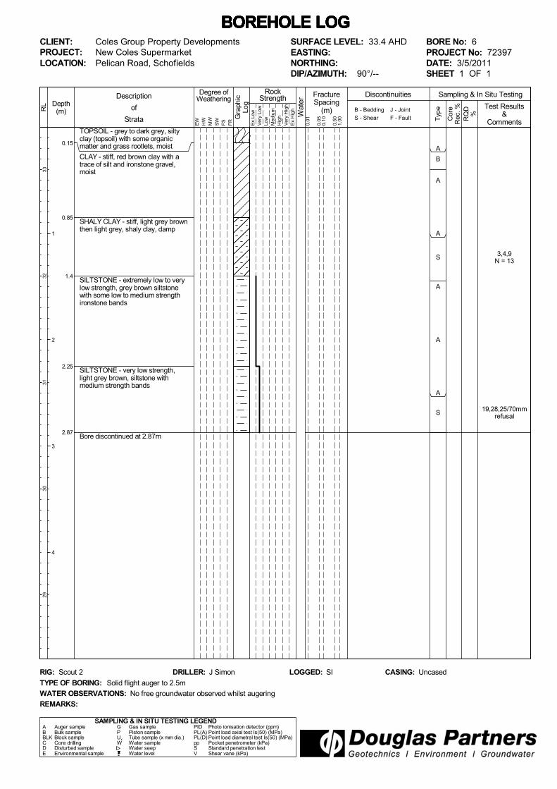
3,4,9N = 13
19,28,25/70mmrefusal
A
B
A
A
S
A
A
A
S
TOPSOIL - grey to dark grey, siltyclay (topsoil) with some organicmatter and grass rootlets, moist
CLAY - stiff, red brown clay with atrace of silt and ironstone gravel,moist
SHALY CLAY - stiff, light grey brownthen light grey, shaly clay, damp
SILTSTONE - extremely low to verylow strength, grey brown siltstonewith some low to medium strengthironstone bands
SILTSTONE - very low strength,light grey brown, siltstone withmedium strength bands
Bore discontinued at 2.87m
0.15
0.85
1.4
2.25
2.87
Wat
er
Degree ofWeathering
EW
HW
MW
SW
FS
FR
Description
of
Strata
FractureSpacing
(m)
0.01
Depth(m) B - Bedding
S - Shear
RockStrength
Typ
e
Sampling & In Situ Testing
Ex
Low
Ver
y Lo
wLo
w
Med
ium
Hig
h
Ver
y H
igh
Ex
Hig
h
0.10
0.50
1.00 R
QD
%
Cor
eR
ec. %
Gra
phic
Log
1
2
3
4
J - Joint
F - Fault
RL
3332
3130
29
Test Results&
Comments0.05
Discontinuities
BOREHOLE LOG BOREHOLE LOG BOREHOLE LOG BOREHOLE LOG BOREHOLE LOG BOREHOLE LOG BOREHOLE LOG CLIENT:PROJECT:LOCATION:
Coles Group Property DevelopmentsNew Coles SupermarketPelican Road, Schofields
SAMPLING & IN SITU TESTING LEGENDA Auger sample G Gas sample PID Photo ionisation detector (ppm)B Bulk sample P Piston sample PL(A) Point load axial test Is(50) (MPa)BLK Block sample Ux Tube sample (x mm dia.) PL(D) Point load diametral test Is(50) (MPa)C Core drilling W Water sample pp Pocket penetrometer (kPa)D Disturbed sample Water seep S Standard penetration testE Environmental sample Water level V Shear vane (kPa)
BORE No: 6PROJECT No: 72397DATE: 3/5/2011SHEET 1 OF 1
WATER OBSERVATIONS: No free groundwater observed whilst augering
TYPE OF BORING: Solid flight auger to 2.5m
RIG: Scout 2 DRILLER: J Simon
REMARKS:
LOGGED: SI CASING: Uncased
SURFACE LEVEL: 33.4 AHDEASTING:NORTHING:DIP/AZIMUTH: 90°/--

6,9,14N = 23
8,16,25/120mmrefusal
A
A
A
S
A
A
A
S
TOPSOIL - dark grey, silty clay(topsoil) with some grass rootlets,moist
CLAY - red brown clay, slightly silty,with trace of ironstone gravel, moist
SHALY CLAY - very stiff, light greyand brown, shaly clay with trace ofironstone band, damp
SILTSTONE - very low strength,light grey to dark grey siltstone withsome low strength bands
Bore discontinued at 2.92m
0.25
0.6
2.0
2.92
Wat
er
Degree ofWeathering
EW
HW
MW
SW
FS
FR
Description
of
Strata
FractureSpacing
(m)
0.01
Depth(m) B - Bedding
S - Shear
RockStrength
Typ
e
Sampling & In Situ Testing
Ex
Low
Ver
y Lo
wLo
w
Med
ium
Hig
h
Ver
y H
igh
Ex
Hig
h
0.10
0.50
1.00 R
QD
%
Cor
eR
ec. %
Gra
phic
Log
1
2
3
4
J - Joint
F - Fault
RL
3130
2928
27
Test Results&
Comments0.05
Discontinuities
BOREHOLE LOG BOREHOLE LOG BOREHOLE LOG BOREHOLE LOG BOREHOLE LOG BOREHOLE LOG BOREHOLE LOG CLIENT:PROJECT:LOCATION:
Coles Group Property DevelopmentsNew Coles SupermarketPelican Road, Schofields
SAMPLING & IN SITU TESTING LEGENDA Auger sample G Gas sample PID Photo ionisation detector (ppm)B Bulk sample P Piston sample PL(A) Point load axial test Is(50) (MPa)BLK Block sample Ux Tube sample (x mm dia.) PL(D) Point load diametral test Is(50) (MPa)C Core drilling W Water sample pp Pocket penetrometer (kPa)D Disturbed sample Water seep S Standard penetration testE Environmental sample Water level V Shear vane (kPa)
BORE No: 7PROJECT No: 72397DATE: 6/5/2011SHEET 1 OF 1
WATER OBSERVATIONS: No free groundwater observed whilst augering
TYPE OF BORING: Solid flight auger to 2.5m
RIG: Scout 2 DRILLER: J Simon
REMARKS:
LOGGED: SI CASING: Uncased
SURFACE LEVEL: 31.8 AHDEASTING:NORTHING:DIP/AZIMUTH: 90°/--

4,7,11N = 18
25/30mmrefusal
A
B
A
A
S
A
A
AS
TOPSOIL - dark grey, silty clay(topsoil) with some grass rootlets,moist
CLAY - red brown clay, slightly silty,with trace of ironstone gravel, moist
SILTY CLAY - very stiff, mottledorange brown and light grey, siltyclay with trace of ironstone gravel,damp to moist
SHALY CLAY - very stiff, light brownshaly clay with ironstone band,damp
SILTSTONE - very low to lowstrength, light brown siltstone withlow to medium strength bands
Bore discontinued at 2.53m
0.25
0.9
1.6
2.1
2.53
Wat
er
Degree ofWeathering
EW
HW
MW
SW
FS
FR
Description
of
Strata
FractureSpacing
(m)
0.01
Depth(m) B - Bedding
S - Shear
RockStrength
Typ
e
Sampling & In Situ Testing
Ex
Low
Ver
y Lo
wLo
w
Med
ium
Hig
h
Ver
y H
igh
Ex
Hig
h
0.10
0.50
1.00 R
QD
%
Cor
eR
ec. %
Gra
phic
Log
1
2
3
4
J - Joint
F - Fault
RL
3433
3231
30
Test Results&
Comments0.05
Discontinuities
BOREHOLE LOG BOREHOLE LOG BOREHOLE LOG BOREHOLE LOG BOREHOLE LOG BOREHOLE LOG BOREHOLE LOG CLIENT:PROJECT:LOCATION:
Coles Group Property DevelopmentsNew Coles SupermarketPelican Road, Schofields
SAMPLING & IN SITU TESTING LEGENDA Auger sample G Gas sample PID Photo ionisation detector (ppm)B Bulk sample P Piston sample PL(A) Point load axial test Is(50) (MPa)BLK Block sample Ux Tube sample (x mm dia.) PL(D) Point load diametral test Is(50) (MPa)C Core drilling W Water sample pp Pocket penetrometer (kPa)D Disturbed sample Water seep S Standard penetration testE Environmental sample Water level V Shear vane (kPa)
BORE No: 8PROJECT No: 72397DATE: 6/5/2011SHEET 1 OF 1
WATER OBSERVATIONS: No free groundwater observed whilst augering
TYPE OF BORING: Solid flight auger to 2.5m
RIG: Scout 2 DRILLER: J Simon
REMARKS:
LOGGED: SI CASING: Uncased
SURFACE LEVEL: 34.0 AHDEASTING:NORTHING:DIP/AZIMUTH: 90°/--

5,12,26N = 38
A
B
A
A
S
A
A
A
SILTY CLAY - grey and grey brown,silty clay with trace of fine gravel,moist
CLAY - red brown clay, slightly silty,with trace of ironstone gravel, moist
SILTY CLAY - very stiff to hard,orange brown silty clay withironstone gravel, damp
SANDSTONE/LAMINITE - very lowstrength, light grey to grey, finegrained sandstone/laminite
Bore discontinued at 2.5m
0.2
0.8
1.3
2.5
Wat
er
Degree ofWeathering
EW
HW
MW
SW
FS
FR
Description
of
Strata
FractureSpacing
(m)
0.01
Depth(m) B - Bedding
S - Shear
RockStrength
Typ
e
Sampling & In Situ Testing
Ex
Low
Ver
y Lo
wLo
w
Med
ium
Hig
h
Ver
y H
igh
Ex
Hig
h
0.10
0.50
1.00 R
QD
%
Cor
eR
ec. %
Gra
phic
Log
1
2
3
4
J - Joint
F - Fault
RL
3433
3231
30
Test Results&
Comments0.05
Discontinuities
BOREHOLE LOG BOREHOLE LOG BOREHOLE LOG BOREHOLE LOG BOREHOLE LOG BOREHOLE LOG BOREHOLE LOG CLIENT:PROJECT:LOCATION:
Coles Group Property DevelopmentsNew Coles SupermarketPelican Road, Schofields
SAMPLING & IN SITU TESTING LEGENDA Auger sample G Gas sample PID Photo ionisation detector (ppm)B Bulk sample P Piston sample PL(A) Point load axial test Is(50) (MPa)BLK Block sample Ux Tube sample (x mm dia.) PL(D) Point load diametral test Is(50) (MPa)C Core drilling W Water sample pp Pocket penetrometer (kPa)D Disturbed sample Water seep S Standard penetration testE Environmental sample Water level V Shear vane (kPa)
BORE No: 9PROJECT No: 72397DATE: 6/5/2011SHEET 1 OF 1
WATER OBSERVATIONS: No free groundwater observed whilst augering
TYPE OF BORING: Solid flight auger to 2.5m
RIG: Scout 2 DRILLER: J Simon
REMARKS:
LOGGED: SI CASING: Uncased
SURFACE LEVEL: 34.3 AHDEASTING:NORTHING:DIP/AZIMUTH: 90°/--

14,25/50mmrefusal
25/20mmrefusal
A
B
A
A
S
A
A
AS
TOPSOIL - dark grey brown, siltyclay (topsoil) with some grassrootlets, moist
CLAY - red brown clay with trace ofsilt and ironstone gravel, moist
SHALY CLAY - very stiff to hard,light grey brown to red brown, shalyclay with trace of ironstone gravel,damp
SANDSTONE - very low strength,light grey, fine grained sandstone
SANDSTONE - very low to lowstrength, grey brown, fine grainedsandstone with low to mediumstrength bands
Bore discontinued at 2.52m
0.25
0.7
1.3
2.2
2.52
Wat
er
Degree ofWeathering
EW
HW
MW
SW
FS
FR
Description
of
Strata
FractureSpacing
(m)
0.01
Depth(m) B - Bedding
S - Shear
RockStrength
Typ
e
Sampling & In Situ Testing
Ex
Low
Ver
y Lo
wLo
w
Med
ium
Hig
h
Ver
y H
igh
Ex
Hig
h
0.10
0.50
1.00 R
QD
%
Cor
eR
ec. %
Gra
phic
Log
1
2
3
4
J - Joint
F - Fault
RL
3433
3231
30
Test Results&
Comments0.05
Discontinuities
BOREHOLE LOG BOREHOLE LOG BOREHOLE LOG BOREHOLE LOG BOREHOLE LOG BOREHOLE LOG BOREHOLE LOG CLIENT:PROJECT:LOCATION:
Coles Group Property DevelopmentsNew Coles SupermarketPelican Road, Schofields
SAMPLING & IN SITU TESTING LEGENDA Auger sample G Gas sample PID Photo ionisation detector (ppm)B Bulk sample P Piston sample PL(A) Point load axial test Is(50) (MPa)BLK Block sample Ux Tube sample (x mm dia.) PL(D) Point load diametral test Is(50) (MPa)C Core drilling W Water sample pp Pocket penetrometer (kPa)D Disturbed sample Water seep S Standard penetration testE Environmental sample Water level V Shear vane (kPa)
BORE No: 10PROJECT No: 72397DATE: 6/5/2011SHEET 1 OF 1
WATER OBSERVATIONS: No free groundwater observed whilst augering
TYPE OF BORING: Solid flight auger to 2.5m
RIG: Scout 2 DRILLER: J Simon
REMARKS:
LOGGED: SI CASING: Uncased
SURFACE LEVEL: 34.6 AHDEASTING:NORTHING:DIP/AZIMUTH: 90°/--

ATTACHMENT E

Client:
Project:
Job No.:
Test Procedure:
Sampling:
Preparation:
Compaction and Placement Data
Compaction Used Standard Dry Density
Maximum Dry Density t/m3 1.75 At Compaction 1.73 t/m
3 99.0 % Comp.
Optimum Moisture Content % 17.8 After Soaking t/m31.71 t/m3 98.0 % Comp.
No. of Layers 3 Moisture Content Moisture Ratio (%)
Blows per Layer 53 At Compaction % 17.8 100
Drop of Rammer mm 300 After Soaking % 20.1 113
Mass of Rammer kg 2.7 After Penetration (Top 30mm) % 23.5 132
Surcharge Used kg 4.5 After Penetration (Entire Depth) % 19.0 107
% Ret. 19mm Sieve 0 Swell After 4 Days Soaking %% 1.8
Note: material coarser than +19mm Sieve was discarded (as per test method)
California Bearing Ratio
CBR (4-day Soaked) = 4.5 % at 2.5 mm Penetration
Date:
Sampled by Client
AS1289 6.1.1 Soil strength and consolidation tests - Determination of the California Bearing Ratio of a soil - Standard laboratory method for a remoulded specimen
CALIFORNIA BEARING RATIO REPORT
Geo-Logix Pty Ltd
Address:Building Q2, Level 3, 2309/4 Daydream St,
Warriewood, NSW 2102
U8 10 Bradford Street
Alexandria NSW 2015
Prepared in accordance with the test method
Source:
Sample Description:
Report No.:
Lab No.:
AS1289 5.1.1 Soil compaction and density tests - Determination of the dry density/moisture content relationship of a soil using standard compactive effort
Schofields PO2223 (1701104)
S17425
Silty CLAY
S28726-CBR
S28726
TP17 0.2-0.5m
Unknown
AS1289 2.1.1 Soil moisture content tests - Determination of the moisture content of a soil - Oven drying method (standard method
Date Sampled:
Macquarie Geotechnical
Lo
ad
(K
N)
16/11/2017
Authorised Signatory:
Chris Lloyd
Penetration (mm)
NATA Accredited Laboratory Number: 14874
Notes:
0
0.2
0.4
0.6
0.8
1
1.2
1.4
1.6
0.00 1.00 2.00 3.00 4.00 5.00 6.00 7.00 8.00 9.00 10.00 11.00 12.00 13.00
The results of the tests, calibrations and/or measurements includedin this document are traceable to Australian/national standards.Accredited for compliance with ISO/IEC 17025. This document shallnot be reproduced, except in full.
Report Form: CBR-Rta Issue 1 - Revision A - Issue Date 1/2/12 Page1of1

Client: Source:
Project: Report No:
Job No: Lab No:
Test Procedure: AS1289.5.1.1 Determination of the dry density/moisture content relation of a soil using standard compactive effort
AS1289.2.1.1 Determination of the moisture content of a soil - Oven drying method (Standard method)
Sampling:
Authorised Signatory:
NATA Accredited Laboratory Number: 14874
DRY DENSITY / OPTIMUM MOISTURE CONTENT REPORT
Preparation:
Silty CLAYBuilding Q2, Level 3, 2309/4 Daydream St, Warriewood,
NSW 2102Address:
S28726-MDD
S28726
UnknownDate Sampled:
S17425
Sampled by Client
Schofields PO2223 (1701104)
Sample
Description:
Prepared in accordance with the test method
Geo-Logix Pty Ltd TP17 0.2-0.5m
U8 10 Bradford Street
Alexandria NSW 2015
Maximum Dry Density (t/m3)
Optimum Moisture Content (%)
Percentage Oversize on 19mm sieve (%)
Percentage Oversize on 37.5mm sieve (%)
1.749
17.8
0
0
Macquarie Geotechnical
Date:
16/11/2017
Chris Lloyd
The results of the tests, calibrations and/or measurements includedin this document are traceable to Australian/national standards.Accredited for compliance with ISO/IEC 17025. This document shallnot be reproduced, except in full.
1.65
1.67
1.69
1.71
1.73
1.75
1.77
15.0 16.0 17.0 18.0 19.0 20.0 21.0
Stan
dar
d D
ry D
en
sity
(t/
m3
)
Moisture Content (%)
Dry Density/Moisture Content Relationship
Report Form:MDD Issue 1 - Revision F - Issue Date 25/10/15 Page1of1

Client: Source:
Project: Report No:
Job No: Lab No:
Test Procedure: AS1289 2.1.1
AS1289 3.1.1
AS1289 3.1.2 Soil classification tests - Determination of the liquid limit if a soil - One point Casagrande method (subsidiary method)
AS1289 3.2.1
AS1289 3.3.1
AS1289 3.4.1
Sampling:
Liquid Limit (%): 55 Linear Shrinkage (%): 12.0
Plastic Limit (%): 17 Plastic Index: 38
Field Moisture Content (%): -
Soil Preparation Method:
Soil History:
NATA Accredited Laboratory Number: 14874
Geo-Logix Pty Ltd TP17 0.2-0.5m
SOIL CLASSIFICATION REPORT
Preparation:
Silty CLAYBuilding Q2, Level 3, 2309/4 Daydream St, Warriewood,
NSW 2102Address:
Soil classification tests - Determination of the linear shrinkage of a soil - Standard method
S28726-PI
S28726
UnknownDate Sampled:
Soil classification tests - Determination of the plastic limit of a soil - Standard method
S17425
Soil moisture content tests (Oven drying method)
Authorised Signatory:
Sampled by Client
Schofields PO2223 (1701104)
Sample
Description:
Soil classification tests - Determination of the liquid limit of a soil - Four point casagrande method
Prepared in accordance with the test method
Chris Lloyd
Soil classification tests - Calculation of the plasticity Index of a soil
Air Dried
Soil Condition:
Dry Sieved
Linear
U8 10 Bradford Street
Alexandria NSW 2015
Macquarie Geotechnical
Date:
16/11/2017
The results of the tests, calibrations and/or measurements included in thisdocument are traceable to Australian/national standards. Accredited forcompliance with ISO/IEC 17025. This document shall not be reproduced,except in full.
Inorganic Silts and Clays
0
5
10
15
20
25
30
35
40
10 20 30 40 50 60 70 80
Pla
sti
cit
y I
nd
ex %
Liquid Limit %
Plasticity Chart for Classification of Fine-grained Soils
Clay
Silt
Report Form:PI LS Issue 1 - Revision F - Issue Date 22/02/17 Page1of1
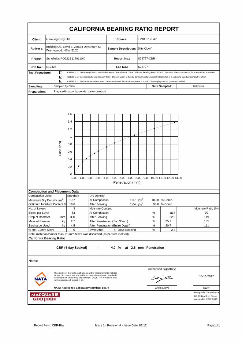
Client:
Project:
Job No.:
Test Procedure:
Sampling:
Preparation:
Compaction and Placement Data
Compaction Used Standard Dry Density
Maximum Dry Density t/m3 1.67 At Compaction 1.67 t/m
3 100.0 % Comp.
Optimum Moisture Content % 18.6 After Soaking t/m31.64 t/m3 98.0 % Comp.
No. of Layers 3 Moisture Content Moisture Ratio (%)
Blows per Layer 53 At Compaction % 18.4 99
Drop of Rammer mm 300 After Soaking % 22.2 119
Mass of Rammer kg 2.7 After Penetration (Top 30mm) % 25.1 135
Surcharge Used kg 4.5 After Penetration (Entire Depth) % 20.7 111
% Ret. 19mm Sieve 0 Swell After 4 Days Soaking %% 2.2
Note: material coarser than +19mm Sieve was discarded (as per test method)
California Bearing Ratio
CBR (4-day Soaked) = 4.0 % at 2.5 mm Penetration
Date:
Sampled by Client
AS1289 6.1.1 Soil strength and consolidation tests - Determination of the California Bearing Ratio of a soil - Standard laboratory method for a remoulded specimen
CALIFORNIA BEARING RATIO REPORT
Geo-Logix Pty Ltd
Address:Building Q2, Level 3, 2309/4 Daydream St,
Warriewood, NSW 2102
U8 10 Bradford Street
Alexandria NSW 2015
Prepared in accordance with the test method
Source:
Sample Description:
Report No.:
Lab No.:
AS1289 5.1.1 Soil compaction and density tests - Determination of the dry density/moisture content relationship of a soil using standard compactive effort
Schofields PO2223 (1701104)
S17425
Silty CLAY
S28727-CBR
S28727
TP18 0.1-0.4m
Unknown
AS1289 2.1.1 Soil moisture content tests - Determination of the moisture content of a soil - Oven drying method (standard method
Date Sampled:
Macquarie Geotechnical
Lo
ad
(K
N)
16/11/2017
Authorised Signatory:
Chris Lloyd
Penetration (mm)
NATA Accredited Laboratory Number: 14874
Notes:
0
0.2
0.4
0.6
0.8
1
1.2
1.4
1.6
0.00 1.00 2.00 3.00 4.00 5.00 6.00 7.00 8.00 9.00 10.00 11.00 12.00 13.00
The results of the tests, calibrations and/or measurements includedin this document are traceable to Australian/national standards.Accredited for compliance with ISO/IEC 17025. This document shallnot be reproduced, except in full.
Report Form: CBR-Rta Issue 1 - Revision A - Issue Date 1/2/12 Page1of1

Client: Source:
Project: Report No:
Job No: Lab No:
Test Procedure: AS1289.5.1.1 Determination of the dry density/moisture content relation of a soil using standard compactive effort
AS1289.2.1.1 Determination of the moisture content of a soil - Oven drying method (Standard method)
Sampling:
Authorised Signatory:
NATA Accredited Laboratory Number: 14874
DRY DENSITY / OPTIMUM MOISTURE CONTENT REPORT
Preparation:
Silty CLAYBuilding Q2, Level 3, 2309/4 Daydream St, Warriewood,
NSW 2102Address:
S28727-MDD
S28727
UnknownDate Sampled:
S17425
Sampled by Client
Schofields PO2223 (1701104)
Sample
Description:
Prepared in accordance with the test method
Geo-Logix Pty Ltd TP18 0.1-0.4m
U8 10 Bradford Street
Alexandria NSW 2015
Maximum Dry Density (t/m3)
Optimum Moisture Content (%)
Percentage Oversize on 19mm sieve (%)
Percentage Oversize on 37.5mm sieve (%)
1.670
18.6
0
0
Macquarie Geotechnical
Date:
16/11/2017
Chris Lloyd
The results of the tests, calibrations and/or measurements includedin this document are traceable to Australian/national standards.Accredited for compliance with ISO/IEC 17025. This document shallnot be reproduced, except in full.
1.56
1.58
1.60
1.62
1.64
1.66
1.68
17.0 18.0 19.0 20.0 21.0 22.0 23.0
Stan
dar
d D
ry D
en
sity
(t/
m3
)
Moisture Content (%)
Dry Density/Moisture Content Relationship
Report Form:MDD Issue 1 - Revision F - Issue Date 25/10/15 Page1of1

Client: Source:
Project: Report No:
Job No: Lab No:
Test Procedure: AS1289 2.1.1
AS1289 3.1.1
AS1289 3.1.2 Soil classification tests - Determination of the liquid limit if a soil - One point Casagrande method (subsidiary method)
AS1289 3.2.1
AS1289 3.3.1
AS1289 3.4.1
Sampling:
Liquid Limit (%): 55 Linear Shrinkage (%): 12.0
Plastic Limit (%): 18 Plastic Index: 37
Field Moisture Content (%): -
Soil Preparation Method:
Soil History:
NATA Accredited Laboratory Number: 14874
Geo-Logix Pty Ltd TP18 0.1-0.4m
SOIL CLASSIFICATION REPORT
Preparation:
Silty CLAYBuilding Q2, Level 3, 2309/4 Daydream St, Warriewood,
NSW 2102Address:
Soil classification tests - Determination of the linear shrinkage of a soil - Standard method
S28727-PI
S28727
UnknownDate Sampled:
Soil classification tests - Determination of the plastic limit of a soil - Standard method
S17425
Soil moisture content tests (Oven drying method)
Authorised Signatory:
Sampled by Client
Schofields PO2223 (1701104)
Sample
Description:
Soil classification tests - Determination of the liquid limit of a soil - Four point casagrande method
Prepared in accordance with the test method
Chris Lloyd
Soil classification tests - Calculation of the plasticity Index of a soil
Air Dried
Soil Condition:
Dry Sieved
Linear
U8 10 Bradford Street
Alexandria NSW 2015
Macquarie Geotechnical
Date:
16/11/2017
The results of the tests, calibrations and/or measurements included in thisdocument are traceable to Australian/national standards. Accredited forcompliance with ISO/IEC 17025. This document shall not be reproduced,except in full.
Inorganic Silts and Clays
0
5
10
15
20
25
30
35
40
10 20 30 40 50 60 70 80
Pla
sti
cit
y I
nd
ex %
Liquid Limit %
Plasticity Chart for Classification of Fine-grained Soils
Clay
Silt
Report Form:PI LS Issue 1 - Revision F - Issue Date 22/02/17 Page1of1

Client:
Project:
Job No.:
Test Procedure:
Sampling:
Preparation:
Compaction and Placement Data
Compaction Used Standard Dry Density
Maximum Dry Density t/m3 1.64 At Compaction 1.66 t/m
3 101.0 % Comp.
Optimum Moisture Content % 20.6 After Soaking t/m31.63 t/m3 99.0 % Comp.
No. of Layers 3 Moisture Content Moisture Ratio (%)
Blows per Layer 53 At Compaction % 20.6 100
Drop of Rammer mm 300 After Soaking % 23.9 116
Mass of Rammer kg 2.7 After Penetration (Top 30mm) % 26.6 129
Surcharge Used kg 4.5 After Penetration (Entire Depth) % 22.4 109
% Ret. 19mm Sieve 1 Swell After 4 Days Soaking %% 1.8
Note: material coarser than +19mm Sieve was discarded (as per test method)
California Bearing Ratio
CBR (4-day Soaked) = 6.0 % at 2.5 mm Penetration
Date:
Sampled by Client
AS1289 6.1.1 Soil strength and consolidation tests - Determination of the California Bearing Ratio of a soil - Standard laboratory method for a remoulded specimen
CALIFORNIA BEARING RATIO REPORT
Geo-Logix Pty Ltd
Address:Building Q2, Level 3, 2309/4 Daydream St,
Warriewood, NSW 2102
U8 10 Bradford Street
Alexandria NSW 2015
Prepared in accordance with the test method
Source:
Sample Description:
Report No.:
Lab No.:
AS1289 5.1.1 Soil compaction and density tests - Determination of the dry density/moisture content relationship of a soil using standard compactive effort
Schofields PO2223 (1701104)
S17425
Silty CLAY
S28728-CBR
S28728
TP19 0.2-0.5m
Unknown
AS1289 2.1.1 Soil moisture content tests - Determination of the moisture content of a soil - Oven drying method (standard method
Date Sampled:
Macquarie Geotechnical
Lo
ad
(K
N)
16/11/2017
Authorised Signatory:
Chris Lloyd
Penetration (mm)
NATA Accredited Laboratory Number: 14874
Notes:
0
0.2
0.4
0.6
0.8
1
1.2
1.4
1.6
1.8
0.00 1.00 2.00 3.00 4.00 5.00 6.00 7.00 8.00 9.00 10.00 11.00 12.00 13.00
The results of the tests, calibrations and/or measurements includedin this document are traceable to Australian/national standards.Accredited for compliance with ISO/IEC 17025. This document shallnot be reproduced, except in full.
Report Form: CBR-Rta Issue 1 - Revision A - Issue Date 1/2/12 Page1of1

Client: Source:
Project: Report No:
Job No: Lab No:
Test Procedure: AS1289.5.1.1 Determination of the dry density/moisture content relation of a soil using standard compactive effort
AS1289.2.1.1 Determination of the moisture content of a soil - Oven drying method (Standard method)
Sampling:
Authorised Signatory:
NATA Accredited Laboratory Number: 14874
DRY DENSITY / OPTIMUM MOISTURE CONTENT REPORT
Preparation:
Silty CLAYBuilding Q2, Level 3, 2309/4 Daydream St, Warriewood,
NSW 2102Address:
S28728-MDD
S28728
UnknownDate Sampled:
S17425
Sampled by Client
Schofields PO2223 (1701104)
Sample
Description:
Prepared in accordance with the test method
Geo-Logix Pty Ltd TP19 0.2-0.5m
U8 10 Bradford Street
Alexandria NSW 2015
Maximum Dry Density (t/m3)
Optimum Moisture Content (%)
Percentage Oversize on 19mm sieve (%)
Percentage Oversize on 37.5mm sieve (%)
1.641
20.6
1
0
Macquarie Geotechnical
Date:
16/11/2017
Chris Lloyd
The results of the tests, calibrations and/or measurements includedin this document are traceable to Australian/national standards.Accredited for compliance with ISO/IEC 17025. This document shallnot be reproduced, except in full.
1.50
1.52
1.54
1.56
1.58
1.60
1.62
1.64
1.66
17.0 18.0 19.0 20.0 21.0 22.0 23.0
Stan
dar
d D
ry D
en
sity
(t/
m3
)
Moisture Content (%)
Dry Density/Moisture Content Relationship
Report Form:MDD Issue 1 - Revision F - Issue Date 25/10/15 Page1of1

Client: Source:
Project: Report No:
Job No: Lab No:
Test Procedure: AS1289 2.1.1
AS1289 3.1.1
AS1289 3.1.2 Soil classification tests - Determination of the liquid limit if a soil - One point Casagrande method (subsidiary method)
AS1289 3.2.1
AS1289 3.3.1
AS1289 3.4.1
Sampling:
Liquid Limit (%): 70 Linear Shrinkage (%): 14.0
Plastic Limit (%): 20 Plastic Index: 50
Field Moisture Content (%): -
Soil Preparation Method:
Soil History:
NATA Accredited Laboratory Number: 14874
Geo-Logix Pty Ltd TP19 0.2-0.5m
SOIL CLASSIFICATION REPORT
Preparation:
Silty CLAYBuilding Q2, Level 3, 2309/4 Daydream St, Warriewood,
NSW 2102Address:
Soil classification tests - Determination of the linear shrinkage of a soil - Standard method
S28728-PI
S28728
UnknownDate Sampled:
Soil classification tests - Determination of the plastic limit of a soil - Standard method
S17425
Soil moisture content tests (Oven drying method)
Authorised Signatory:
Sampled by Client
Schofields PO2223 (1701104)
Sample
Description:
Soil classification tests - Determination of the liquid limit of a soil - Four point casagrande method
Prepared in accordance with the test method
Chris Lloyd
Soil classification tests - Calculation of the plasticity Index of a soil
Oven Dried
Soil Condition:
Dry Sieved
Curling Occuring
U8 10 Bradford Street
Alexandria NSW 2015
Macquarie Geotechnical
Date:
16/11/2017
The results of the tests, calibrations and/or measurements included in thisdocument are traceable to Australian/national standards. Accredited forcompliance with ISO/IEC 17025. This document shall not be reproduced,except in full.
Inorganic Silts and Clays
0
10
20
30
40
50
60
10 20 30 40 50 60 70 80
Pla
sti
cit
y I
nd
ex %
Liquid Limit %
Plasticity Chart for Classification of Fine-grained Soils
Clay
Silt
Report Form:PI LS Issue 1 - Revision F - Issue Date 22/02/17 Page1of1
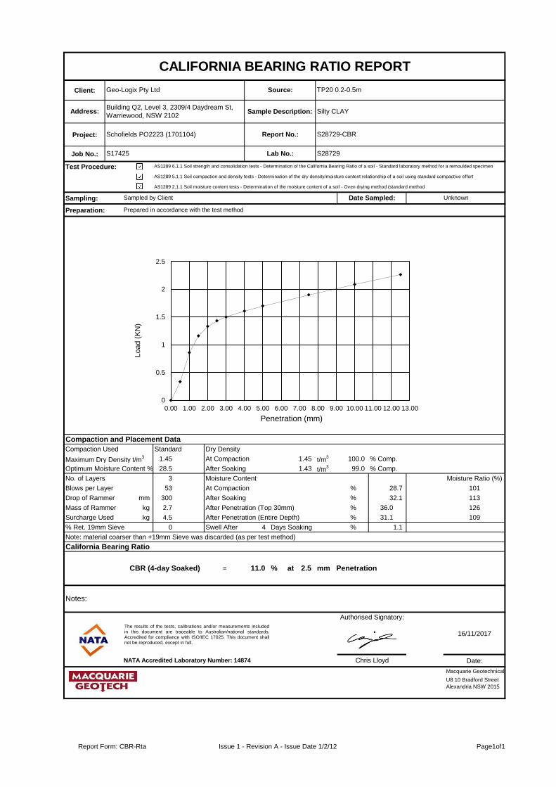
Client:
Project:
Job No.:
Test Procedure:
Sampling:
Preparation:
Compaction and Placement Data
Compaction Used Standard Dry Density
Maximum Dry Density t/m3 1.45 At Compaction 1.45 t/m
3 100.0 % Comp.
Optimum Moisture Content % 28.5 After Soaking t/m31.43 t/m3 99.0 % Comp.
No. of Layers 3 Moisture Content Moisture Ratio (%)
Blows per Layer 53 At Compaction % 28.7 101
Drop of Rammer mm 300 After Soaking % 32.1 113
Mass of Rammer kg 2.7 After Penetration (Top 30mm) % 36.0 126
Surcharge Used kg 4.5 After Penetration (Entire Depth) % 31.1 109
% Ret. 19mm Sieve 0 Swell After 4 Days Soaking %% 1.1
Note: material coarser than +19mm Sieve was discarded (as per test method)
California Bearing Ratio
CBR (4-day Soaked) = 11.0 % at 2.5 mm Penetration
Date:
Sampled by Client
AS1289 6.1.1 Soil strength and consolidation tests - Determination of the California Bearing Ratio of a soil - Standard laboratory method for a remoulded specimen
CALIFORNIA BEARING RATIO REPORT
Geo-Logix Pty Ltd
Address:Building Q2, Level 3, 2309/4 Daydream St,
Warriewood, NSW 2102
U8 10 Bradford Street
Alexandria NSW 2015
Prepared in accordance with the test method
Source:
Sample Description:
Report No.:
Lab No.:
AS1289 5.1.1 Soil compaction and density tests - Determination of the dry density/moisture content relationship of a soil using standard compactive effort
Schofields PO2223 (1701104)
S17425
Silty CLAY
S28729-CBR
S28729
TP20 0.2-0.5m
Unknown
AS1289 2.1.1 Soil moisture content tests - Determination of the moisture content of a soil - Oven drying method (standard method
Date Sampled:
Macquarie Geotechnical
Lo
ad
(K
N)
16/11/2017
Authorised Signatory:
Chris Lloyd
Penetration (mm)
NATA Accredited Laboratory Number: 14874
Notes:
0
0.5
1
1.5
2
2.5
0.00 1.00 2.00 3.00 4.00 5.00 6.00 7.00 8.00 9.00 10.00 11.00 12.00 13.00
The results of the tests, calibrations and/or measurements includedin this document are traceable to Australian/national standards.Accredited for compliance with ISO/IEC 17025. This document shallnot be reproduced, except in full.
Report Form: CBR-Rta Issue 1 - Revision A - Issue Date 1/2/12 Page1of1
Client: Source:
Project: Report No:
Job No: Lab No:
Test Procedure: AS1289.5.1.1 Determination of the dry density/moisture content relation of a soil using standard compactive effort
AS1289.2.1.1 Determination of the moisture content of a soil - Oven drying method (Standard method)
Sampling:
Authorised Signatory:
NATA Accredited Laboratory Number: 14874
DRY DENSITY / OPTIMUM MOISTURE CONTENT REPORT
Preparation:
Silty CLAYBuilding Q2, Level 3, 2309/4 Daydream St, Warriewood,
NSW 2102Address:
S28729-MDD
S28729
UnknownDate Sampled:
S17425
Sampled by Client
Schofields PO2223 (1701104)
Sample
Description:
Prepared in accordance with the test method
Geo-Logix Pty Ltd TP20 0.2-0.5m
U8 10 Bradford Street
Alexandria NSW 2015
Maximum Dry Density (t/m3)
Optimum Moisture Content (%)
Percentage Oversize on 19mm sieve (%)
Percentage Oversize on 37.5mm sieve (%)
1.448
28.5
0
0
Macquarie Geotechnical
Date:
16/11/2017
Chris Lloyd
The results of the tests, calibrations and/or measurements includedin this document are traceable to Australian/national standards.Accredited for compliance with ISO/IEC 17025. This document shallnot be reproduced, except in full.
1.38
1.39
1.40
1.41
1.42
1.43
1.44
1.45
1.46
26.0 27.0 28.0 29.0 30.0 31.0 32.0 33.0
Stan
dar
d D
ry D
en
sity
(t/
m3
)
Moisture Content (%)
Dry Density/Moisture Content Relationship
Report Form:MDD Issue 1 - Revision F - Issue Date 25/10/15 Page1of1

Client: Source:
Project: Report No:
Job No: Lab No:
Test Procedure: AS1289 2.1.1
AS1289 3.1.1
AS1289 3.1.2 Soil classification tests - Determination of the liquid limit if a soil - One point Casagrande method (subsidiary method)
AS1289 3.2.1
AS1289 3.3.1
AS1289 3.4.1
Sampling:
Liquid Limit (%): 84 Linear Shrinkage (%): 18.0
Plastic Limit (%): 28 Plastic Index: 56
Field Moisture Content (%): -
Soil Preparation Method:
Soil History:
NATA Accredited Laboratory Number: 14874
Geo-Logix Pty Ltd TP20 0.2-0.5m
SOIL CLASSIFICATION REPORT
Preparation:
Silty CLAYBuilding Q2, Level 3, 2309/4 Daydream St, Warriewood,
NSW 2102Address:
Soil classification tests - Determination of the linear shrinkage of a soil - Standard method
S28729-PI
S28729
UnknownDate Sampled:
Soil classification tests - Determination of the plastic limit of a soil - Standard method
S17425
Soil moisture content tests (Oven drying method)
Authorised Signatory:
Sampled by Client
Schofields PO2223 (1701104)
Sample
Description:
Soil classification tests - Determination of the liquid limit of a soil - Four point casagrande method
Prepared in accordance with the test method
Chris Lloyd
Soil classification tests - Calculation of the plasticity Index of a soil
Oven Dried
Soil Condition:
Dry Sieved
Curling Occuring
U8 10 Bradford Street
Alexandria NSW 2015
Macquarie Geotechnical
Date:
16/11/2017
The results of the tests, calibrations and/or measurements included in thisdocument are traceable to Australian/national standards. Accredited forcompliance with ISO/IEC 17025. This document shall not be reproduced,except in full.
Inorganic Silts and Clays
0
10
20
30
40
50
60
10 20 30 40 50 60 70 80 90
Pla
sti
cit
y I
nd
ex %
Liquid Limit %
Plasticity Chart for Classification of Fine-grained Soils
Clay
Silt
Report Form:PI LS Issue 1 - Revision F - Issue Date 22/02/17 Page1of1
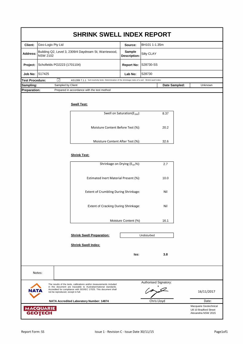
Client: Source:
Project: Report No:
Job No: Lab No:
Test Procedure: AS1289 7.1.1
Sampling:
Swell Test:
Swell on Saturation(ESW): 8.37
Moisture Content Before Test (%): 20.2
Moisture Content After Test (%): 32.6
Shrink Test:
Shrinkage on Drying (ESH%): 2.7
Estimated Inert Material Present (%): 10.0
Extent of Crumbling During Shrinkage: Nil
Extent of Cracking During Shrinkage: Nil
Moisture Content (%) 16.1
Shrink Swell Preparation:
Shrink Swell Index:
Iss: 3.8
Authorised Signatory:
NATA Accredited Laboratory Number: 14874
Macquarie Geotechnical
Date:
16/11/2017
Prepared in accordance with the test method
Chris Lloyd
U8 10 Bradford Street
Alexandria NSW 2015
SHRINK SWELL INDEX REPORT
Preparation:
Silty CLAYBuilding Q2, Level 3, 2309/4 Daydream St, Warriewood,
NSW 2102Address:
S28730-SS
S28730
UnknownDate Sampled:
S17425
Soil reactivity tests- Determination of the shrinkage index of a soil - Shrink-swell index
Sampled by Client
Schofields PO2223 (1701104)
Sample
Description:
Notes:
Geo-Logix Pty Ltd BH101 1-1.35m
Undisturbed
The results of the tests, calibrations and/or measurements includedin this document are traceable to Australian/national standards.Accredited for compliance with ISO/IEC 17025. This document shallnot be reproduced, except in full.
Report Form: SS Issue 1 - Revision C - Issue Date 30/11/15 Page1of1

Client: Source:
Project: Report No:
Job No: Lab No:
Test Procedure: AS1289 7.1.1
Sampling:
Swell Test:
Swell on Saturation(ESW): 4.24
Moisture Content Before Test (%): 15.6
Moisture Content After Test (%): 25.6
Shrink Test:
Shrinkage on Drying (ESH%): 1.7
Estimated Inert Material Present (%): 10.0
Extent of Crumbling During Shrinkage: Nil
Extent of Cracking During Shrinkage: Mild
Moisture Content (%) 14.1
Shrink Swell Preparation:
Shrink Swell Index:
Iss: 2.1
Authorised Signatory:
NATA Accredited Laboratory Number: 14874
Macquarie Geotechnical
Date:
16/11/2017
Prepared in accordance with the test method
Chris Lloyd
U8 10 Bradford Street
Alexandria NSW 2015
SHRINK SWELL INDEX REPORT
Preparation:
Silty CLAYBuilding Q2, Level 3, 2309/4 Daydream St, Warriewood,
NSW 2102Address:
S28731-SS
S28731
UnknownDate Sampled:
S17425
Soil reactivity tests- Determination of the shrinkage index of a soil - Shrink-swell index
Sampled by Client
Schofields PO2223 (1701104)
Sample
Description:
Notes:
Geo-Logix Pty Ltd BH103 0.5-0.8m
Undisturbed
The results of the tests, calibrations and/or measurements includedin this document are traceable to Australian/national standards.Accredited for compliance with ISO/IEC 17025. This document shallnot be reproduced, except in full.
Report Form: SS Issue 1 - Revision C - Issue Date 30/11/15 Page1of1

Client: Source:
Project: Report No:
Job No: Lab No:
Test Procedure: AS1289 7.1.1
Sampling:
Swell Test:
Swell on Saturation(ESW): 4.76
Moisture Content Before Test (%): 15.8
Moisture Content After Test (%): 21.6
Shrink Test:
Shrinkage on Drying (ESH%): 2.1
Estimated Inert Material Present (%): 10.0
Extent of Crumbling During Shrinkage: Nil
Extent of Cracking During Shrinkage: Mild
Moisture Content (%) 11.0
Shrink Swell Preparation:
Shrink Swell Index:
Iss: 2.5
Authorised Signatory:
NATA Accredited Laboratory Number: 14874
Macquarie Geotechnical
Date:
16/11/2017
Prepared in accordance with the test method
Chris Lloyd
U8 10 Bradford Street
Alexandria NSW 2015
SHRINK SWELL INDEX REPORT
Preparation:
Silty CLAYBuilding Q2, Level 3, 2309/4 Daydream St, Warriewood,
NSW 2102Address:
S28732-SS
S28732
UnknownDate Sampled:
S17425
Soil reactivity tests- Determination of the shrinkage index of a soil - Shrink-swell index
Sampled by Client
Schofields PO2223 (1701104)
Sample
Description:
Notes:
Geo-Logix Pty Ltd BH106 0.5-0.8m
Undisturbed
The results of the tests, calibrations and/or measurements includedin this document are traceable to Australian/national standards.Accredited for compliance with ISO/IEC 17025. This document shallnot be reproduced, except in full.
Report Form: SS Issue 1 - Revision C - Issue Date 30/11/15 Page1of1

Client: Source:
Project: Report No:
Job No: Lab No:
Test Procedure: AS1289 7.1.1
Sampling:
Swell Test:
Swell on Saturation(ESW): 4.05
Moisture Content Before Test (%): 22.6
Moisture Content After Test (%): 32.0
Shrink Test:
Shrinkage on Drying (ESH%): 2.3
Estimated Inert Material Present (%): 10.0
Extent of Crumbling During Shrinkage: Nil
Extent of Cracking During Shrinkage: Mild
Moisture Content (%) 19.1
Shrink Swell Preparation:
Shrink Swell Index:
Iss: 2.4
Authorised Signatory:
NATA Accredited Laboratory Number: 14874
Macquarie Geotechnical
Date:
16/11/2017
Prepared in accordance with the test method
Chris Lloyd
U8 10 Bradford Street
Alexandria NSW 2015
SHRINK SWELL INDEX REPORT
Preparation:
Silty CLAYBuilding Q2, Level 3, 2309/4 Daydream St, Warriewood,
NSW 2102Address:
S28733-SS
S28733
UnknownDate Sampled:
S17425
Soil reactivity tests- Determination of the shrinkage index of a soil - Shrink-swell index
Sampled by Client
Schofields PO2223 (1701104)
Sample
Description:
Notes:
Geo-Logix Pty Ltd BH111 0.5-0.9m
Undisturbed
The results of the tests, calibrations and/or measurements includedin this document are traceable to Australian/national standards.Accredited for compliance with ISO/IEC 17025. This document shallnot be reproduced, except in full.
Report Form: SS Issue 1 - Revision C - Issue Date 30/11/15 Page1of1

Client:
Moisture
Content
Condition:
Project: Report No:
Job No: Date Tested:
Test Procedure: AS4133 4.1
Sampling:
Sample
NumberSample Description
Average Width
(mm)
Platen
Separation
(mm)
Failure
Load
(kN)
Point Load
Index Is(50)
(MPa)
Failure Mode
- 49.0 1.89 0.78 1
51.0 22.0 0.94 0.58 1
- 49.0 0.66 0.27 1
51.0 23.0 2.05 1.22 1
- 49.0 0.76 0.31 1
51.0 30.0 5.16 2.50 1
- 49.0 0.48 0.20 1
51.0 27.0 2.64 1.39 1
- 45.0 8.65 4.07 1
52.0 22.0 4.67 2.84 1
- 49.0 0.36 0.15 1
52.0 21.0 0.94 0.59 1
- 49.0 1.51 0.62 1
52.0 29.0 5.10 2.50 1
- 49.0 0.97 0.40 1
52.0 18.0 3.77 2.68 1
- 49.0 0.43 0.18 1
52.0 26.0 7.18 3.84 1
- 49.0 1.29 0.53 1
52.0 30.0 2.55 1.22 1
NATA Accredited Laboratory Number: 14874 Date
S28734b
S28734a
SandstoneS28734c
Sandstone
Sandstone
Sandstone
Sandstone
BH105 4.44-4.53m
BH105 5.48-5.53m
BH105 6-6.06m
BH110 4.14-4.21m
Point Load
Index Is
(MPa)
0.79
0.66
0.27
1.37
BH110 5.2-5.27m
BH110 6-6.08m
Sandstone
3.21
0.15
0.68
Sample Source
Axial
Diametral
Axial
Diametral
Axial
0.32
2.65
0.20
1.51
4.27
Diametral
S28736d
S28736c
S28735b
S28735a
S28736b
S28736a
S28735c
Diametral
Axial
Diametral
Axial
Diametral
Diametral
Axial
Axial
Axial
Diametral
Axial
Axial
DiametralSandstone
Sandstone
Sandstone
Sandstone
Failure Modes
Macquarie Geotechnical
4 - Chip or partial fracture.
POINT LOAD STRENGTH INDEX REPORT
Storage
History:
Preparation:
Core BoxesBuilding Q2, Level 3, 2309/4 Daydream St, Warriewood,
NSW 2102Address:
S28734-PL
7/11/2017
As ReceivedGeo-Logix Pty Ltd
Schofields PO2223 (1701104)
S17425
Rock strength tests - Determination of point load strength index
Prepared in accordance with the test method
Sampled by Client Date Sampled: Unknown
Test Type
U8 10 Bradford
Street
Alexandria NSW
3 - Fracture influenced by pre-existing plane, microfracture, vein or chemical alteration.
2 - Fracture along bedding.
1 - Fracture through fabric of specimen oblique to bedding, not influenced by weak planes.
Chris Lloyd
1.28
Authorised Signatory:
16/11/2017
0.40
3.16
0.18
4.17
0.54
BH111 2.78-2.85m
BH111 3.83-3.88m
BH111 4.66-4.73m
BH111 5.71-5.78m
Diametral
0.63
2.66
The results of the tests, calibrations and/or measurements included in thisdocument are traceable to Australian/national standards. Accredited forcompliance with ISO/IEC 17025. This document shall not be reproduced,except in full.
Report Form: PL - RMS Issue 1 - Revision C - Issue Date 10/02/17 Page1of1

Client: Source:
Project: Report No.:
Job No.: Lab No.:
Test Procedure: AS4133 4.2.1
AS4133 4.2.2
Sampling:
Matest
Average
Diameter
(mm)
Specimen
Height
(mm)
Length/
Diameter
Ratio
Duration of
Test (Sec)
Load at
Fracture
(kN)
Moisture
Content at
Time of
Test (%)
51.40 131.6 2.56 653 90 1.9
Notes:
Authorised Signatory:
NATA Accredited Laboratory Number: 14874
U8 10 Bradford Street
Alexandria NSW 2015
Compressive Strength
(MPa)
43.4
Macquarie Geotechnical
Date:
6/11/2017
Specimen Condition
As received
Chris Lloyd
Date Sampled: Unknown
TEST RESULTS
Before Test After Test
Description of Failure
Mixed mode
Date Tested 1/11/2017 Machine Type Sample Storage Conditions Wrapped
UNIAXIAL COMPRESSIVE STRENGTH OF ROCK REPORT
Sample
Description:
Preparation:
SandstoneBuilding Q2, Level 3, 2309/4 Daydream St, Warriewood,
NSW 2102Address:
S28737-UCS
S28737
BH105 5-5.1mGeo-Logix Pty Ltd
Schofields PO2223 (1701104)
S17425
Rock strength tests - Determination of uniaxial compressive strength - Rock Strength < 50 Mpa
Rock strength tests - Determination of uniaxial compressive strength - Rock Strength >50MPa
Prepared in accordance with the test method
Sampled by Client
The results of the tests, calibrations and/or measurements includedin this document are traceable to Australian/national standards.Accredited for compliance with ISO/IEC 17025. This document shallnot be reproduced, except in full.
Report Form: UCS - AS Issue 1 - Revision F - Issue Date 19/4/17 Page1of1

Client: Source:
Project: Report No.:
Job No.: Lab No.:
Test Procedure: AS4133 4.2.1
AS4133 4.2.2
Sampling:
Matest
Average
Diameter
(mm)
Specimen
Height
(mm)
Length/
Diameter
Ratio
Duration of
Test (Sec)
Load at
Fracture
(kN)
Moisture
Content at
Time of
Test (%)
51.30 135.3 2.64 631 44 2.8
Notes:
Authorised Signatory:
NATA Accredited Laboratory Number: 14874
U8 10 Bradford Street
Alexandria NSW 2015
Compressive Strength
(MPa)
21.1
Macquarie Geotechnical
Date:
6/11/2017
Specimen Condition
As received
Chris Lloyd
Date Sampled: Unknown
TEST RESULTS
Before Test After Test
Description of Failure
Single shear plane
Date Tested 1/11/2017 Machine Type Sample Storage Conditions Wrapped
UNIAXIAL COMPRESSIVE STRENGTH OF ROCK REPORT
Sample
Description:
Preparation:
SandstoneBuilding Q2, Level 3, 2309/4 Daydream St, Warriewood,
NSW 2102Address:
S28738-UCS
S28738
BH110 4.9-5mGeo-Logix Pty Ltd
Schofields PO2223 (1701104)
S17425
Rock strength tests - Determination of uniaxial compressive strength - Rock Strength < 50 Mpa
Rock strength tests - Determination of uniaxial compressive strength - Rock Strength >50MPa
Prepared in accordance with the test method
Sampled by Client
The results of the tests, calibrations and/or measurements includedin this document are traceable to Australian/national standards.Accredited for compliance with ISO/IEC 17025. This document shallnot be reproduced, except in full.
Report Form: UCS - AS Issue 1 - Revision F - Issue Date 19/4/17 Page1of1

Client: Source:
Project: Report No.:
Job No.: Lab No.:
Test Procedure: AS4133 4.2.1
AS4133 4.2.2
Sampling:
Matest
Average
Diameter
(mm)
Specimen
Height
(mm)
Length/
Diameter
Ratio
Duration of
Test (Sec)
Load at
Fracture
(kN)
Moisture
Content at
Time of
Test (%)
51.60 137.4 2.66 667 89 1.7
Notes:
Authorised Signatory:
NATA Accredited Laboratory Number: 14874
U8 10 Bradford Street
Alexandria NSW 2015
Compressive Strength
(MPa)
42.6
Macquarie Geotechnical
Date:
6/11/2017
Specimen Condition
As received
Chris Lloyd
Date Sampled: Unknown
TEST RESULTS
Before Test After Test
Description of Failure
Mixed mode
Date Tested 2/11/2017 Machine Type Sample Storage Conditions Wrapped
UNIAXIAL COMPRESSIVE STRENGTH OF ROCK REPORT
Sample
Description:
Preparation:
SandstoneBuilding Q2, Level 3, 2309/4 Daydream St, Warriewood,
NSW 2102Address:
S28739-UCS
S28739
BH111 5-5.1mGeo-Logix Pty Ltd
Schofields PO2223 (1701104)
S17425
Rock strength tests - Determination of uniaxial compressive strength - Rock Strength < 50 Mpa
Rock strength tests - Determination of uniaxial compressive strength - Rock Strength >50MPa
Prepared in accordance with the test method
Sampled by Client
The results of the tests, calibrations and/or measurements includedin this document are traceable to Australian/national standards.Accredited for compliance with ISO/IEC 17025. This document shallnot be reproduced, except in full.
Report Form: UCS - AS Issue 1 - Revision F - Issue Date 19/4/17 Page1of1
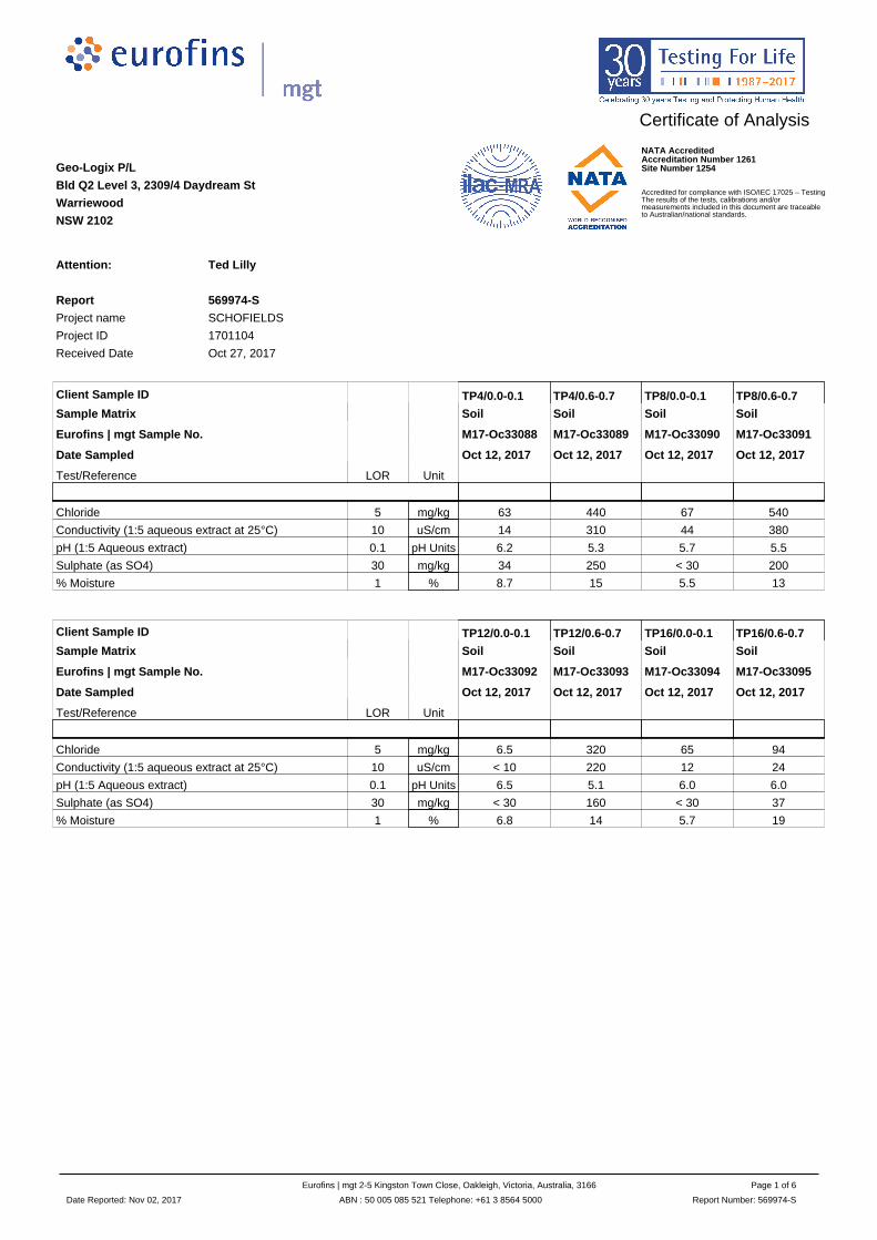
Certificate of Analysis
Geo-Logix P/L
Bld Q2 Level 3, 2309/4 Daydream St
Warriewood
NSW 2102
Attention: Ted Lilly
Report 569974-S
Project name SCHOFIELDS
Project ID 1701104
Received Date Oct 27, 2017
Client Sample ID TP4/0.0-0.1 TP4/0.6-0.7 TP8/0.0-0.1 TP8/0.6-0.7
Sample Matrix Soil Soil Soil Soil
Eurofins | mgt Sample No. M17-Oc33088 M17-Oc33089 M17-Oc33090 M17-Oc33091
Date Sampled Oct 12, 2017 Oct 12, 2017 Oct 12, 2017 Oct 12, 2017
Test/Reference LOR Unit
Chloride 5 mg/kg 63 440 67 540
Conductivity (1:5 aqueous extract at 25°C) 10 uS/cm 14 310 44 380
pH (1:5 Aqueous extract) 0.1 pH Units 6.2 5.3 5.7 5.5
Sulphate (as SO4) 30 mg/kg 34 250 < 30 200
% Moisture 1 % 8.7 15 5.5 13
Client Sample ID TP12/0.0-0.1 TP12/0.6-0.7 TP16/0.0-0.1 TP16/0.6-0.7
Sample Matrix Soil Soil Soil Soil
Eurofins | mgt Sample No. M17-Oc33092 M17-Oc33093 M17-Oc33094 M17-Oc33095
Date Sampled Oct 12, 2017 Oct 12, 2017 Oct 12, 2017 Oct 12, 2017
Test/Reference LOR Unit
Chloride 5 mg/kg 6.5 320 65 94
Conductivity (1:5 aqueous extract at 25°C) 10 uS/cm < 10 220 12 24
pH (1:5 Aqueous extract) 0.1 pH Units 6.5 5.1 6.0 6.0
Sulphate (as SO4) 30 mg/kg < 30 160 < 30 37
% Moisture 1 % 6.8 14 5.7 19
Date Reported: Nov 02, 2017
Eurofins | mgt 2-5 Kingston Town Close, Oakleigh, Victoria, Australia, 3166
ABN : 50 005 085 521 Telephone: +61 3 8564 5000
Page 1 of 6
Report Number: 569974-S
NATA AccreditedAccreditation Number 1261Site Number 1254
Accredited for compliance with ISO/IEC 17025 – TestingThe results of the tests, calibrations and/ormeasurements included in this document are traceableto Australian/national standards.

Sample HistoryWhere samples are submitted/analysed over several days, the last date of extraction and analysis is reported.A recent review of our LIMS has resulted in the correction or clarification of some method identifications. Due to this, some of the method reference information on reports has changed. However,no substantive change has been made to our laboratory methods, and as such there is no change in the validity of current or previous results (regarding both quality and NATA accreditation).
If the date and time of sampling are not provided, the Laboratory will not be responsible for compromised results should testing be performed outside the recommended holding time.
Description Testing Site Extracted Holding Time
Eurofins | mgt Suite B18
Chloride Melbourne Oct 30, 2017 28 Day
- Method: LTM-INO-4090 Chloride by Discrete Analyser
pH (1:5 Aqueous extract) Melbourne Oct 30, 2017 7 Day
- Method: LTM-GEN-7090 pH in soil by ISE
Sulphate (as SO4) Melbourne Oct 30, 2017 28 Day
- Method: LTM-INO-4110 Sulfate by Discrete Analyser
Conductivity (1:5 aqueous extract at 25°C) Melbourne Oct 30, 2017 7 Day
- Method: LTM-INO-4030
% Moisture Melbourne Oct 30, 2017 14 Day
- Method: LTM-GEN-7080 Moisture
Date Reported: Nov 02, 2017
Eurofins | mgt 2-5 Kingston Town Close, Oakleigh, Victoria, Australia, 3166
ABN : 50 005 085 521 Telephone: +61 3 8564 5000
Page 2 of 6
Report Number: 569974-S

.Company Name: Geo-Logix P/L Order No.: Received: Oct 27, 2017 9:28 AMAddress: Bld Q2 Level 3, 2309/4 Daydream St Report #: 569974 Due: Nov 3, 2017
Warriewood Phone: 02 9979 1722 Priority: 5 DayNSW 2102 Fax: 02 9979 1222 Contact Name: Ted Lilly
Project Name: SCHOFIELDSProject ID: 1701104
Eurofins | mgt Analytical Services Manager : Nibha Vaidya
Sample Detail
Conductivity (1:5 aqueous extract at 25°C
)
Eurofins | m
gt Suite B
18
Moisture S
et
Melbourne Laboratory - NATA Site # 1254 & 14271 X X X
Sydney Laboratory - NATA Site # 18217
Brisbane Laboratory - NATA Site # 20794
Perth Laboratory - NATA Site # 23736
External Laboratory
No Sample ID Sample Date SamplingTime
Matrix LAB ID
1 TP4/0.0-0.1 Oct 12, 2017 Soil M17-Oc33088 X X X
2 TP4/0.6-0.7 Oct 12, 2017 Soil M17-Oc33089 X X X
3 TP8/0.0-0.1 Oct 12, 2017 Soil M17-Oc33090 X X X
4 TP8/0.6-0.7 Oct 12, 2017 Soil M17-Oc33091 X X X
5 TP12/0.0-0.1 Oct 12, 2017 Soil M17-Oc33092 X X X
6 TP12/0.6-0.7 Oct 12, 2017 Soil M17-Oc33093 X X X
7 TP16/0.0-0.1 Oct 12, 2017 Soil M17-Oc33094 X X X
8 TP16/0.6-0.7 Oct 12, 2017 Soil M17-Oc33095 X X X
Test Counts 8 8 8
ABN– 50 005 085 521e.mail : [email protected] : www.eurofins.com.au
MelbourneMelbourneMelbourneMelbourne2-5 Kingston Town CloseOakleigh VIC 3166Phone : +61 3 8564 5000NATA # 1261Site # 1254 & 14271
SydneySydneySydneySydneyUnit F3, Building F16 Mars RoadLane Cove West NSW 2066Phone : +61 2 9900 8400NATA # 1261 Site # 18217
BrisbaneBrisbaneBrisbaneBrisbane1/21 Smallwood PlaceMurarrie QLD 4172Phone : +61 7 3902 4600NATA # 1261 Site # 20794
PerthPerthPerthPerth2/91 Leach HighwayKewdale WA 6105Phone : +61 8 9251 9600NATA # 1261Site # 23736
Date Reported:Nov 02, 2017
Eurofins | mgt 2-5 Kingston Town Close, Oakleigh, Victoria, Australia, 3166
ABN : 50 005 085 521 Telephone: +61 3 8564 5000
Page 3 of 6
Report Number: 569974-S

Internal Quality Control Review and Glossary
General
Holding Times
Units
Terms
QC - Acceptance Criteria
QC Data General Comments
1. Laboratory QC results for Method Blanks, Duplicates, Matrix Spikes, and Laboratory Control Samples are included in this QC report where applicable. Additional QC data may be available on
request.
2. All soil results are reported on a dry basis, unless otherwise stated.
3. All biota results are reported on a wet weight basis on the edible portion, unless otherwise stated.
4. Actual LORs are matrix dependant. Quoted LORs may be raised where sample extracts are diluted due to interferences.
5. Results are uncorrected for matrix spikes or surrogate recoveries except for PFAS compounds.
6. SVOC analysis on waters are performed on homogenised, unfiltered samples, unless noted otherwise.
7. Samples were analysed on an 'as received' basis.
8. This report replaces any interim results previously issued.
Please refer to 'Sample Preservation and Container Guide' for holding times (QS3001).
For samples received on the last day of holding time, notification of testing requirements should have been received at least 6 hours prior to sample receipt deadlines as stated on the Sample
Receipt Advice.
If the Laboratory did not receive the information in the required timeframe, and regardless of any other integrity issues, suitably qualified results may still be reported.
Holding times apply from the date of sampling, therefore compliance to these may be outside the laboratory's control.
**NOTE: pH duplicates are reported as a range NOT as RPD
mg/kg: milligrams per kilogram mg/L: milligrams per litre
ug/L: micrograms per litre ppm: Parts per million
ppb: Parts per billion %: Percentage
org/100mL: Organisms per 100 millilitres NTU: Nephelometric Turbidity Units
MPN/100mL: Most Probable Number of organisms per 100 millilitres
Dry Where a moisture has been determined on a solid sample the result is expressed on a dry basis.
LOR Limit of Reporting.
SPIKE Addition of the analyte to the sample and reported as percentage recovery.
RPD Relative Percent Difference between two Duplicate pieces of analysis.
LCS Laboratory Control Sample - reported as percent recovery.
CRM Certified Reference Material - reported as percent recovery.
Method Blank In the case of solid samples these are performed on laboratory certified clean sands and in the case of water samples these are performed on de-ionised water.
Surr - Surrogate The addition of a like compound to the analyte target and reported as percentage recovery.
Duplicate A second piece of analysis from the same sample and reported in the same units as the result to show comparison.
USEPA United States Environmental Protection Agency
APHA American Public Health Association
TCLP Toxicity Characteristic Leaching Procedure
COC Chain of Custody
SRA Sample Receipt Advice
QSM Quality Systems Manual ver 5.1 US Department of Defense
CP Client Parent - QC was performed on samples pertaining to this report
NCP Non-Client Parent - QC performed on samples not pertaining to this report, QC is representative of the sequence or batch that client samples were analysed within.
TEQ Toxic Equivalency Quotient
RPD Duplicates: Global RPD Duplicates Acceptance Criteria is 30% however the following acceptance guidelines are equally applicable:
Results <10 times the LOR : No Limit
Results between 10-20 times the LOR : RPD must lie between 0-50%
Results >20 times the LOR : RPD must lie between 0-30%
Surrogate Recoveries: Recoveries must lie between 50-150%-Phenols & PFASs
PFAS field samples that contain surrogate recoveries in excess of the QC limit designated in QSM 5.1 where no positive PFAS results have been reported have been reviewed and no data was
affected.
1. Where a result is reported as a less than (<), higher than the nominated LOR, this is due to either matrix interference, extract dilution required due to interferences or contaminant levels within
the sample, high moisture content or insufficient sample provided.
2. Duplicate data shown within this report that states the word "BATCH" is a Batch Duplicate from outside of your sample batch, but within the laboratory sample batch at a 1:10 ratio. The Parent
and Duplicate data shown is not data from your samples.
3. Organochlorine Pesticide analysis - where reporting LCS data, Toxaphene & Chlordane are not added to the LCS.
4. Organochlorine Pesticide analysis - where reporting Spike data, Toxaphene is not added to the Spike.
5. Total Recoverable Hydrocarbons - where reporting Spike & LCS data, a single spike of commercial Hydrocarbon products in the range of C12-C30 is added and it's Total Recovery is reported
in the C10-C14 cell of the Report.
6. pH and Free Chlorine analysed in the laboratory - Analysis on this test must begin within 30 minutes of sampling.Therefore laboratory analysis is unlikely to be completed within holding time.
Analysis will begin as soon as possible after sample receipt.
7. Recovery Data (Spikes & Surrogates) - where chromatographic interference does not allow the determination of Recovery the term "INT" appears against that analyte.
8. Polychlorinated Biphenyls are spiked only using Aroclor 1260 in Matrix Spikes and LCS.
9. For Matrix Spikes and LCS results a dash " -" in the report means that the specific analyte was not added to the QC sample.
10. Duplicate RPDs are calculated from raw analytical data thus it is possible to have two sets of data.
Date Reported: Nov 02, 2017
Eurofins | mgt 2-5 Kingston Town Close, Oakleigh, Victoria, Australia, 3166
ABN : 50 005 085 521 Telephone: +61 3 8564 5000
Page 4 of 6
Report Number: 569974-S
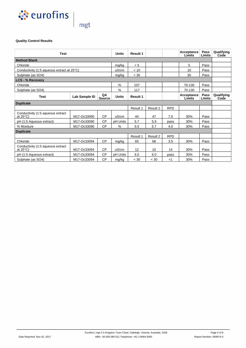
Quality Control Results
Test Units Result 1 AcceptanceLimits
PassLimits
QualifyingCode
Method Blank
Chloride mg/kg < 5 5 Pass
Conductivity (1:5 aqueous extract at 25°C) uS/cm < 10 10 Pass
Sulphate (as SO4) mg/kg < 30 30 Pass
LCS - % Recovery
Chloride % 107 70-130 Pass
Sulphate (as SO4) % 117 70-130 Pass
Test Lab Sample ID QASource Units Result 1 Acceptance
LimitsPass
LimitsQualifying
Code
Duplicate
Result 1 Result 2 RPD
Conductivity (1:5 aqueous extractat 25°C) M17-Oc33090 CP uS/cm 44 47 7.0 30% Pass
pH (1:5 Aqueous extract) M17-Oc33090 CP pH Units 5.7 5.9 pass 30% Pass
% Moisture M17-Oc33090 CP % 5.5 5.7 4.0 30% Pass
Duplicate
Result 1 Result 2 RPD
Chloride M17-Oc33094 CP mg/kg 65 68 3.5 30% Pass
Conductivity (1:5 aqueous extractat 25°C) M17-Oc33094 CP uS/cm 12 10 14 30% Pass
pH (1:5 Aqueous extract) M17-Oc33094 CP pH Units 6.0 6.0 pass 30% Pass
Sulphate (as SO4) M17-Oc33094 CP mg/kg < 30 < 30 <1 30% Pass
Date Reported: Nov 02, 2017
Eurofins | mgt 2-5 Kingston Town Close, Oakleigh, Victoria, Australia, 3166
ABN : 50 005 085 521 Telephone: +61 3 8564 5000
Page 5 of 6
Report Number: 569974-S

Comments
Sample IntegrityCustody Seals Intact (if used) N/A
Attempt to Chill was evident Yes
Sample correctly preserved Yes
Appropriate sample containers have been used Yes
Sample containers for volatile analysis received with minimal headspace Yes
Samples received within HoldingTime Yes
Some samples have been subcontracted No
Comments
Authorised By
Nibha Vaidya Analytical Services Manager
Alex Petridis Senior Analyst-Metal (VIC)
Huong Le Senior Analyst-Inorganic (VIC)
Glenn Jackson
National Operations Manager
- Indicates Not Requested
* Indicates NATA accreditation does not cover the performance of this service
Measurement uncertainty of test data is available on request or please click here.Eurofins | mgt shall not be liable for loss, cost, damages or expenses incurred by the client, or any other person or company, resulting from the use of any information or interpretation given in this report. In no case shall Eurofins | mgt be liable for consequential damages including, but notlimited to, lost profits, damages for failure to meet deadlines and lost production arising from this report. This document shall not be reproduced except in full and relates only to the items tested. Unless indicated otherwise, the tests were performed on the samples as received.
Date Reported: Nov 02, 2017
Eurofins | mgt 2-5 Kingston Town Close, Oakleigh, Victoria, Australia, 3166
ABN : 50 005 085 521 Telephone: +61 3 8564 5000
Page 6 of 6
Report Number: 569974-S

GEO-LOGIX PTY LTD
ABN 86 116 892 936
Building Q2, Level 3
Suite 2309, 4 Daydream Street
Warriewood NSW 2102
Phone 02 9979 1722
Fax 02 9979 1222
Email [email protected]
Web www.geo-logix.com.au