Geotechnical Engineering Report - PIKEPASS: … Geotechnical Report.pdfTerracon performed subgrade...
78
Geotechnical Engineering Report Shoulder Soil Survey H.E. Bailey Turnpike From Mile Post 99 to Mile Post 107 Grady and McClain Counties, Oklahoma January 11, 2016 Terracon Project No. 03156643 Prepared for: Triad Design Group Oklahoma City, Oklahoma Prepared by: Terracon Consultants, Inc. Oklahoma City, Oklahoma
Transcript of Geotechnical Engineering Report - PIKEPASS: … Geotechnical Report.pdfTerracon performed subgrade...

Geotechnical Engineering ReportShoulder Soil SurveyH.E. Bailey Turnpike
From Mile Post 99 to Mile Post 107Grady and McClain Counties, Oklahoma
January 11, 2016Terracon Project No. 03156643
Prepared for:Triad Design Group
Oklahoma City, Oklahoma
Prepared by:Terracon Consultants, Inc.Oklahoma City, Oklahoma


Geotechnical Engineering ReportShoulder Soil Survey ■ H.E. Bailey TurnpikeMile Post 99 to Mile Post 107 ■ Grady and McClain Counties, OklahomaJanuary 11, 2016 ■ Terracon Project No. 03156643
Responsive ■ Resourceful ■ Reliable
TABLE OF CONTENTS
Page
1.0 INTRODUCTION .............................................................................................................12.0 PROJECT INFORMATION .............................................................................................13.0 DATA COLLECTION AND FINDINGS ............................................................................1
3.1 Pavement Cores ..................................................................................................13.2 Subgrade Borings ................................................................................................2
4.0 PAVEMENT SECTION RECOMMENDATIONS ..............................................................34.1 Earthwork.............................................................................................................3
4.1.1 Site Preparation ........................................................................................34.1.2 Subgrade Preparation...............................................................................34.1.3 Fill Material Requirements ........................................................................44.1.4 Fill Placement Compaction Requirements ................................................54.1.5 Utility Trench Backfill ................................................................................5
4.2 Traffic ...................................................................................................................64.3 Pavement Design Parameters .............................................................................64.4 Pavement Section Alternatives ............................................................................64.5 Drainage ..............................................................................................................74.6 Maintenance ........................................................................................................7
5.0 GENERAL COMMENTS .................................................................................................8
APPENDIX A - FIELD EXPLORATION
Exhibit A-1 Site Location DiagramExhibits A-2 Boring Location TableExhibits A-3 to A-10 Pavement Core Logs (C-1 to C-8)Exhibit A-11 In-Place Soil Survey Table
APPENDIX B - LABORATORY TESTING
Exhibits B-1 to B-4 Bulk Sample Proctor CurvesExhibits B-5 to B-8 Bulk Sample Resilient Modulus Data
APPENDIX C - SUPPORTING DOCUMENTS
Exhibit C-1 General NotesExhibit C-2 Unified Soil Classification System

Responsive ■ Resourceful ■ Reliable 1
GEOTECHNICAL ENGINEERING REPORTSHOULDER SOIL SURVEY
H.E. BAILEY TURNPIKEFROM MILE POST 99 TO MILE POST 107
GRADY AND MCCLAIN COUNTIES, OKLAHOMATerracon Project No. 03156643
January 11, 2016
1.0 INTRODUCTION
The shoulder soil survey services performed on the H.E. Bailey Turnpike from Mile Post 99to Mile Post 107 in Grady and McClain Counties, Oklahoma, have been completed.Terracon performed subgrade sampling, pavement coring and laboratory testing. Theresults of the borings and diagrams showing their approximate locations are included in thisreport. This report discusses the data collection methods, presents the data collected andprovides recommendations for pavement subgrade preparation and pavement sectionthicknesses.
2.0 PROJECT INFORMATION
The project is located on the H.E. Bailey Turnpike from near Mile Post 99 (Station 538+00)to near Mile Post 107 (Station 973+00) with a total project length of approximately 8.25miles. We understand that the existing pavement is to be removed and a new pavementsection will be reconstructed along the same grade and alignment.
3.0 DATA COLLECTION AND FINDINGS
3.1 Pavement Cores
Eight pavement cores were collected on the outside wheel path of outside lane in eastboundand westbound directions at the locations shown in Exhibit A-2 - Boring Location Table ofAppendix A. The core locations were located by Terracon in the field using the stationnumbers painted on the roadway by a representative of the Client.
The cores were 4 inches in diameter and penetrated the bound layers of thepavement. Diamond impregnated core barrels were used to cut the cores. Water was usedto flush cuttings to the surface and cool the core barrel bit. After collecting the cores, thecore locations were backfilled with similar materials.

Geotechnical Engineering ReportShoulder Soil Survey ■ H.E. Bailey TurnpikeMile Post 99 to Mile Post 107 ■ Grady and McClain Counties, OklahomaJanuary 11, 2016 ■ Terracon Project No. 03156643
Responsive ■ Resourceful ■ Reliable 2
An engineer examined each of the pavement cores in the laboratory to evaluate thethickness of each pavement layer. The cores were observed for the presence of voids,honeycombing, weathering of the pavement and “D” cracking of Portland cement concretematerials. These observations are recorded on the core logs included in Exhibits A-3 to A-10 in Appendix A.
Review of the field measurements show that the cores generally consist of Portland cementconcrete ranging in thickness from 8 3/4 to 9 inches. The Portland cement concrete wasunderlain by soil cement ranging in thickness from 3 to 4 1/2 inches in borings C-2 throughC-8. In boring C-1, the Portland cement concrete was underlain by aggregate base with athickness of 6 inches. Logs of the cores are presented on the Pavement Core Logs inExhibits A-3 through A-10 in Appendix A.
3.2 Subgrade Borings
A total of eighty-nine borings were drilled along the shoulder at 1,000 feet intervals in eachdirection staggered 500 feet in the opposing direction.
Disturbed subgrade samples at the shoulder boring locations were obtained using hand-auger techniques. The borings were drilled to a depth of approximately 36 inches below theexisting surface. The subsurface profiles are shown in the Shoulder Soil Survey Table inExhibit A-11. The soil samples collected from the borings were sealed and returned to thelaboratory for testing.
Four representative bulk samples were obtained in the field. The bulk samples were testedfor Atterberg limits and sieve analysis. The bulk sample was also tested for standardProctor moisture-density and resilient modulus. The results are included in Appendix B. Abrief description of the USCS classification system is included in Appendix C.
COMPOSITE SAMPLE
SampleDesignation
SourceMaterial
Maximum Unit Weight& Optimum Moisture
AASHTO T-99
PercentFiner than
No.200Sieve
AtterbergLimits(LL/PI)
AASHTOClassification
Bulk 1 W-2: 6 - 36” 114.2 / 14.3 72 32 / 18 A-6(10)
Bulk 2 W-15: 6 - 36” 113.4 / 13.6 40 22 / 3 A-4(0)
Bulk 3 E-9: 6 - 36” 107.3 / 13.4 17 NP / NP A-2-4(0)
Bulk 4 E-35: 6 - 36” 112.8 / 14.6 60 39 / 21 A-6(10)

Geotechnical Engineering ReportShoulder Soil Survey ■ H.E. Bailey TurnpikeMile Post 99 to Mile Post 107 ■ Grady and McClain Counties, OklahomaJanuary 11, 2016 ■ Terracon Project No. 03156643
Responsive ■ Resourceful ■ Reliable 3
Subgrade soils encountered in the borings generally consist of various shades of brown, redand yellow, sands with varying amounts of silt and clay and lean clay with varying amountsof sand to the boring termination depths of approximately 18 to 36 inches. Hand augerrefusal was encountered in borings W-18, W-31, W-35, W-36, W-41, W-44, E-8, E-11, E-27,E-29, E-30, E-34 and E-36 at depths ranging from about 18 to 35 inches.
Borings W-28 and E-31 encountered ground water at a depth of approximately 35 inches.The water encountered may be perched water and may not be actual groundwater table.
Laboratory resilient modulus tests were performed on the bulk samples at the soil’s optimummoisture content and at least 2 percentage points above optimum moisture content. Basedon these values and our previous experience with soils similar to those encountered on-site,we selected a subgrade modulus of 5,444 psi for pavement design. Individual modulus testresults are included in Appendix B.
4.0 PAVEMENT SECTION RECOMMENDATIONS
4.1 Earthwork
The following presents recommendations for subgrade preparation and construction ofengineered fills on the project. The recommendations presented for design and constructionof the pavements are contingent upon following the recommendations outlined in thissection. Grading should extend an appropriate distance beyond the limits of the proposedpavement areas.
4.1.1 Site PreparationSite preparation for the proposed project should include removing the existing pavement,vegetation, topsoil, and other unsuitable materials encountered on-site. Actual removaldepths should be determined at the time of construction by a representative of thegeotechnical engineer.
4.1.2 Subgrade PreparationThe near surface soils at the boring locations generally consisted of sand with varyingamounts of silt and clay, and lean clay with varying amounts of sand. Recommendationsregarding subgrade preparation are provided in the following paragraphs.
All pavement areas should be stripped of any existing pavement, vegetation, topsoil and softor otherwise unsuitable materials. After stripping the site and completing any required cuts,but before placing fill, we recommend the exposed subgrade be proofrolled with a loaded

Geotechnical Engineering ReportShoulder Soil Survey ■ H.E. Bailey TurnpikeMile Post 99 to Mile Post 107 ■ Grady and McClain Counties, OklahomaJanuary 11, 2016 ■ Terracon Project No. 03156643
Responsive ■ Resourceful ■ Reliable 4
tandem-axle dump truck having a minimum gross weight of 25 tons or other equipmenthaving a similar subgrade loading. Depressions or excavations should be cleaned of loosematerial and backfilled as outlined in the following paragraphs. Soft, unstable soil locatedduring the proofrolling should be overexcavated and replaced with properly compactedapproved soils if it cannot be adequately compacted in place. We expect the subgrade soilsbeneath the existing pavement section to have accumulated moisture over the life of thepavement. The extent of unstable soil cannot be determined at this time. Proofrollingshould be observed by a representative of the geotechnical engineer.
Following site stripping and proofrolling, the exposed subgrade in areas to receive new fillshould be scarified to a depth of 8 inches, adjusted to a workable moisture content that iswithin 2 percent of its optimum value and be compacted to at least 95 percent of thematerial’s maximum dry density as determined by test method AASHTO T-99 (standardProctor).
To reduce potential trafficability problems and strength loss, and to improve the long-termsubgrade support, we recommend that the top 8 inches of the subgrade be stabilized withClass “C” fly ash or cement kiln dust. Based on past experience with soils similar to thosepresent at the site, we estimate 10 to 14 percent Class “C” fly ash or cement kiln dust will beneeded to adequately stabilize the on-site soils. The actual percentage of additive shouldbe determined at the time of construction by the geotechnical engineer. We recommendfollowing ODOT’s OHD L-50 for determining percentage of fly ash or CKD. Beforecompaction, the stabilized soil zone should be adjusted to within 2 percent of the material’soptimum moisture as determined by test method AASHTO T-99. After conditioning the soilto the required moisture content, the stabilized subgrade should be compacted to at least 98percent of the material’s maximum dry density as determined by test method AASHTO T-99. Compaction should be completed within about two hours after initially mixing the soiland stabilizing agent to optimize the stabilization benefit.
4.1.3 Fill Material RequirementsAll fill required to develop the design subgrade elevation should be an approved materialthat is free of organic matter and debris as outlined in the following table.
Fill Type1 Acceptable Location for Placement
On-Site Soils (with 5<PI< 25) Pavement areas2
1. Prior to any filling operations, samples of the proposed borrow and on-sitematerials should be obtained for laboratory Atterberg limits and moisture-density testing. The tests will provide a basis for material acceptance andevaluation of fill compaction by in-place density testing. A qualified soiltechnician should perform sufficient in-place density tests during the fillingoperations to evaluate that proper levels of compaction, including dry unit

Geotechnical Engineering ReportShoulder Soil Survey ■ H.E. Bailey TurnpikeMile Post 99 to Mile Post 107 ■ Grady and McClain Counties, OklahomaJanuary 11, 2016 ■ Terracon Project No. 03156643
Responsive ■ Resourceful ■ Reliable 5
weight and moisture content, are being attained. Controlled, compacted fillshould consist of approved materials free of organic matter and debris andcontain a maximum rock size of 3 inches. The proposed fill materialsshould be approved by the geotechnical engineer prior to placement.
2. Provided the top 8 inches of the pavement subgrade is stabilized withClass “C” fly ash or cement kiln dust as discussed in section 4.1.2Subgrade Preparation.
Engineered fill should be placed and compacted in horizontal lifts, using equipment andprocedures that will produce recommended moisture contents and densities throughout thelift.
4.1.4 Fill Placement Compaction RequirementsRecommended compaction and moisture content criteria for engineered fill materials are asfollows:
Item Description
Fill Lift Thickness 9-inches or less in loose thickness
Compaction Requirements
At least 95% of the material’s maximum dry density asdetermined by the standard Proctor test method, AASHTO T-99,except the stabilized depth of pavement subgrade should be atleast 98%.
Moisture ContentWorkable moisture content that is within 2 percent of its optimumvalue as determined by the standard Proctor test method,AASHTO T-99 at the time of placement and compaction
4.1.5 Utility Trench BackfillCare should be taken to properly backfill utility cuts in pavement areas. All trenches createdfor utility access under the pavement should be effectively sealed to restrict water intrusionand flow along the trenches. We recommend using a clay soil to construct a trench plugthat extends at least 5 feet out from the edge of the pavements. The clay should have aminimum plasticity index (PI) of 15 and be placed in controlled lifts not exceeding 9 inches inloose thickness so as to surround the utility line and fill the trench. Each lift of clay backfillshould be compacted to at least 95 percent of the material’s maximum standard Proctor drydensity (AASHTO T-99), at a minimum moisture content that is 2 percentage points abovethe optimum value.

Geotechnical Engineering ReportShoulder Soil Survey ■ H.E. Bailey TurnpikeMile Post 99 to Mile Post 107 ■ Grady and McClain Counties, OklahomaJanuary 11, 2016 ■ Terracon Project No. 03156643
Responsive ■ Resourceful ■ Reliable 6
4.2 Traffic
The project traffic data was provided to us by Triad Design Group as follows:
n ADT 2016 = 19,825 (Two way)n ADT 2035 = 35,806 (Two way)n Directional distribution, D = 55%n Truck traffic, T (% ADT) = 16%
If there is a change in the design traffic loading, the updated traffic information should besubmitted for our review regarding any potential changes to our design recommendations.
4.3 Pavement Design Parameters
Based on the field and laboratory test results and our previous experience with soils similarto those encountered on site, and the assumption that the pavement subgrade will beconstructed as recommended in the previous paragraphs, a reliability value of 95% and asubgrade strength (MR) of 5,444 psi were used in the analyses.
4.4 Pavement Section Alternatives
Flexible and rigid pavement sections were determined using the AASHTO Ware Pavement-ME 2.1. Based on the analyses discussed above, the following pavement sections can beconsidered for this project.
MINIMUM PAVEMENT RECOMMENDATIONS *
Detour Shoo-Fly H.E. Bailey Turnpike Mainline
Section IPortland CementConcrete
(4,000 psi, AirEntrained)
8.0” Plain Jointed Concrete with 14foot lane8.0” Stabilized Subgrade
10.0” Dowel Jointed Concrete with 14 footoutside lane and tied concrete shoulders15 oz./SY Non-woven Separator Fabric 4.0” Cement Treated Base 8.0” Stabilized Subgrade

Geotechnical Engineering ReportShoulder Soil Survey ■ H.E. Bailey TurnpikeMile Post 99 to Mile Post 107 ■ Grady and McClain Counties, OklahomaJanuary 11, 2016 ■ Terracon Project No. 03156643
Responsive ■ Resourceful ■ Reliable 7
MINIMUM PAVEMENT RECOMMENDATIONS *
Detour Shoo-Fly H.E. Bailey Turnpike Mainline
Section IIFull DepthAsphaltic Concrete
2.0” S4 PG 64-22OK3.0” S3 PG 64-22OK3.0” S3 PG 64-22OK8.0” Stabilized Subgrade
1.25” PFC PG 76-28OK** 2.0” SMA PG 76-28OK** 3.0” S3 PG 76-28OK** 3.0” S3 PG 64-22OK 3.0” S3 PG 64-22OK 8.0” Aggregate Base Type A***Non-woven Separator Fabric8.0” Stabilized Subgrade
* All materials should meet the ODOT Standard Specifications for Highway Construction. ** PG 64-22OK may be used in lieu of PG 76-28OK in all outside shoulder layers.*** TBSC Type E may be used in lieu of Aggregate Base Type A in the outside shoulder. Use TBSC Type E for shouldering along the outside edge of the pavement shoulders to provide drainage.
These pavement sections are considered minimal sections based upon the expected trafficand the existing subgrade conditions. However, they are expected to function with periodicmaintenance and overlays if effective drainage is provided and maintained.
4.5 Drainage
Minimizing subgrade saturation is an important factor in maintaining subgrade strength.Water allowed to pond on or adjacent to pavements could saturate the subgrade and causepremature pavement deterioration. The pavement should be sloped to provide rapid surfacedrainage, and positive surface drainage should be maintained away from the edge of thepaved areas. Design alternatives that could reduce the risk of subgrade saturation andimprove long term pavement performance include crowning the pavement subgrade to draintoward the edges (rather than to the center of the pavement areas) and installing surfacedrains next to any areas where surface water could pond. In areas where there will beirrigation adjacent to the pavement, we recommend the owner consider installing perimeterdrains for the pavements.
4.6 Maintenance
Periodic maintenance extends the service life of the pavement and should include cracksealing, surface sealing and patching of any deteriorated areas. Also, thicker pavementsections could be used to reduce the required maintenance and extend the service life ofthe pavement. Failure to follow these recommendations could result in premature pavementdistress and higher maintenance costs.

Geotechnical Engineering ReportShoulder Soil Survey ■ H.E. Bailey TurnpikeMile Post 99 to Mile Post 107 ■ Grady and McClain Counties, OklahomaJanuary 11, 2016 ■ Terracon Project No. 03156643
Responsive ■ Resourceful ■ Reliable 8
5.0 GENERAL COMMENTS
The results presented in this report are based upon the data obtained from the pavementcores and borings performed at the indicated location and from any other informationdiscussed in this report. This report does not reflect any variations which may occurbetween cores or borings or across the site. The nature and extent of such variations maynot become evident until construction. If variations appear, it will be necessary to reevaluatethe recommendations of this report.
The scope of services for this project does not include either specifically or by implicationany environmental assessment of the site or identification of contaminated or hazardousmaterials or conditions. If the owner is concerned about the potential for suchcontamination, other studies should be undertaken.
This report has been prepared for the exclusive use of our client for specific application tothe project discussed, and has been prepared in accordance with generally acceptedgeotechnical engineering practices. No warranties, either express or implied are intended ormade. In the event that any changes in the nature, design, or location of the project asoutlined in this report are planned, the conclusions and recommendations contained in thisreport shall not be considered valid unless Terracon Consultants, Inc. reviews the changes,and either verifies or modifies the conclusions of this report in writing.

APPENDIX AFIELD EXPLORATION


Geotechnical Engineering ReportShoulder Soil Survey ■ H.E. Bailey TurnpikeMile Post 99 to Mile Post 107 ■ Grady and McClain Counties, OklahomaJanuary 11, 2016 ■ Terracon Project No. 03156643
Responsive ■ Resourceful ■ Reliable Exhibit A-2
BORING LOCATIONS
Boring Number Direction Station Offset from CL(feet)
C-1 Westbound 928+00 34 LT
C-2 Westbound 823+00 34 LT
C-3 Westbound 718+00 34 LT
C-4 Westbound 608+00 34 LT
C-5 Eastbound 563+00 34 RT
C-6 Eastbound 668+00 34 RT
C-7 Eastbound 773+00 34 RT
C-8 Eastbound 878+00 34 RT
W-1 Westbound 973+00 52 LT
W-2 Westbound 963+00 65 LT
W-3 Westbound 963+00 49 LT
W-4 Westbound 943+00 49 LT
W-5 Westbound 933+00 49 LT
W-6 Westbound 923+00 47 LT
W-7 Westbound 913+00 49 LT
W-8 Westbound 903+00 49 LT
W-9 Westbound 893+00 49 LT
W-10 Westbound 883+00 49 LT
W-11 Westbound 873+00 49 LT
W-12 Westbound 863+00 49 LT
W-13 Westbound 853+00 49 LT
W-14 Westbound 843+00 51 LT
W-15 Westbound 833+00 49 LT
W-16 Westbound 823+00 49 LT

Geotechnical Engineering ReportShoulder Soil Survey ■ H.E. Bailey TurnpikeMile Post 99 to Mile Post 107 ■ Grady and McClain Counties, OklahomaJanuary 11, 2016 ■ Terracon Project No. 03156643
Responsive ■ Resourceful ■ Reliable Exhibit A-2
BORING LOCATIONS
Boring Number Direction Station Offset from CL(feet)
W-17 Westbound 813+00 51 LT
W-18 Westbound 803+00 49 LT
W-19 Westbound 793+00 49 LT
W-20 Westbound 783+00 49 LT
W-21 Westbound 773+00 49 LT
W-22 Westbound 763+06 50 LT
W-23 Westbound 753+00 49 LT
W-24 Westbound 743+00 49 LT
W-25 Westbound 733+00 49 LT
W-26 Westbound 723+00 49 LT
W-27 Westbound 713+00 50 LT
W-28 Westbound 703+00 49 LT
W-29 Westbound 693+00 49 LT
W-30 Westbound 683+00 49 LT
W-31 Westbound 673+06 49 LT
W-32 Westbound 663+00 49 LT
W-33 Westbound 653+00 49 LT
W-34 Westbound 643+06 49 LT
W-35 Westbound 633+00 49 LT
W-36 Westbound 623+00 49 LT
W-37 Westbound 613+06 49 LT
W-38 Westbound 603+00 50 LT
W-39 Westbound 593+00 49 LT
W-40 Westbound 583+00 49 LT

Geotechnical Engineering ReportShoulder Soil Survey ■ H.E. Bailey TurnpikeMile Post 99 to Mile Post 107 ■ Grady and McClain Counties, OklahomaJanuary 11, 2016 ■ Terracon Project No. 03156643
Responsive ■ Resourceful ■ Reliable Exhibit A-2
BORING LOCATIONS
Boring Number Direction Station Offset from CL(feet)
W-41 Westbound 573+06 49 LT
W-42 Westbound 563+00 49 LT
W-43 Westbound 553+00 49 LT
W-44 Westbound 543+00 49 LT
E-1 Eastbound 537+00 49 RT
E-2 Eastbound 548+00 49 RT
E-3 Eastbound 558+00 49 RT
E-4 Eastbound 568+00 49 RT
E-5 Eastbound 578+00 49 RT
E-6 Eastbound 588+00 50 RT
E-7 Eastbound 598+00 50 RT
E-8 Eastbound 608+00 49 RT
E-9 Eastbound 618+00 49 RT
E-10 Eastbound 628+00 49 RT
E-11 Eastbound 638+00 49 RT
E-12 Eastbound 648+00 49 RT
E-13 Eastbound 658+00 49 RT
E-14 Eastbound 668+00 49 RT
E-15 Eastbound 678+00 49 RT
E-16 Eastbound 688+00 49 RT
E-17 Eastbound 698+00 49 RT
E-18 Eastbound 708+00 49 RT
E-19 Eastbound 718+00 49 RT
E-20 Eastbound 728+00 49 RT

Geotechnical Engineering ReportShoulder Soil Survey ■ H.E. Bailey TurnpikeMile Post 99 to Mile Post 107 ■ Grady and McClain Counties, OklahomaJanuary 11, 2016 ■ Terracon Project No. 03156643
Responsive ■ Resourceful ■ Reliable Exhibit A-2
BORING LOCATIONS
Boring Number Direction Station Offset from CL(feet)
E-21 Eastbound 738+00 49 RT
E-22 Eastbound 748+00 49 RT
E-23 Eastbound 758+50 50 RT
E-24 Eastbound 768+00 49 RT
E-25 Eastbound 778+00 49 RT
E-26 Eastbound 788+00 49 RT
E-27 Eastbound 798+00 49 RT
E-28 Eastbound 808+00 49 RT
E-29 Eastbound 818+00 49 RT
E-30 Eastbound 828+00 49 RT
E-31 Eastbound 838+00 49 RT
E-32 Eastbound 848+00 49 RT
E-33 Eastbound 858+00 49 RT
E-34 Eastbound 868+00 49 RT
E-35 Eastbound 878+00 49 RT
E-36 Eastbound 888+00 49 RT
E-37 Eastbound 898+00 49 RT
E-38 Eastbound 908+00 49 RT
E-39 Eastbound 918+00 49 RT
E-40 Eastbound 928+00 49 RT
E-41 Eastbound 938+00 49 RT
E-42 Eastbound 948+00 49 RT
E-43 Eastbound 985+00 49 RT
E-44 Eastbound 968+00 70 RT

Geotechnical Engineering ReportShoulder Soil Survey ■ H.E. Bailey TurnpikeMile Post 99 to Mile Post 107 ■ Grady and McClain Counties, OklahomaJanuary 11, 2016 ■ Terracon Project No. 03156643
Responsive ■ Resourceful ■ Reliable Exhibit A-2
BORING LOCATIONS
Boring Number Direction Station Offset from CL(feet)
E-45 Eastbound 978+00 50 RT

TOP
CORE LOG CORE LAYER DATA (FROM TOP TO BOTTOM):
CORE NUMBER C-1 Sample LayerDATE CORED 12/29/2015 No Thickness (in.)LOCATION H.E. Bailey Turnpike from Mile Post 99 to Mile Post 107 1 9
Grady and McClain Counties, Oklahoma 6STATION 928+00LANE DIRECTION Outside WestboundOFFSET Outside Wheelpath
Total Core Thickness 15
CORE DATA
Surface Material Type:
Stripping or Separation in Asphalt:
Honeycomb or "D" Cracking in PCC:
Water Level ObservationsNone W.D. None A.B.
Exhibit A-3
Layer Type Layer CharacteristicsPortland Cement Concrete Seperation at 9 inchesAggregate Base (Not picutred)
LL, PL, PI AASHTO USCSPercent Passing
No. 200
Stabilized Subgrade Beneath Pavement or Sub-base?
A.C. P.C.C.
Stripping Separation N/A
Honeycomb "D" Cracking N/A
Continuously Reinforced Concrete
Yes No Unknown

TOP
CORE LOG CORE LAYER DATA (FROM TOP TO BOTTOM):
CORE NUMBER C-2 Sample LayerDATE CORED 12/29/2015 No Thickness (in.)LOCATION H.E. Bailey Turnpike from Mile Post 99 to Mile Post 107 1 9
Grady and McClain Counties, Oklahoma 3STATION 823+00LANE DIRECTION Outside WestboundOFFSET Outside Wheelpath
Total Core Thickness 12
CORE DATA
Surface Material Type:
Stripping or Separation in Asphalt:
Honeycomb or "D" Cracking in PCC:
Water Level ObservationsNone W.D. None A.B.
Exhibit A-4
Layer Type Layer CharacteristicsPortland Cement ConcreteSoil Cement
Stabilized Subgrade Beneath Pavement or Sub-base?
Percent PassingNo. 200
LL, PL, PI AASHTO USCS
A.C. P.C.C.
Stripping Separation N/A
Honeycomb "D" Cracking N/A
Continuously Reinforced Concrete
Yes No Unknown

TOP
CORE LOG CORE LAYER DATA (FROM TOP TO BOTTOM):
CORE NUMBER C-3 Sample LayerDATE CORED 12/29/2015 No Thickness (in.)LOCATION H.E. Bailey Turnpike from Mile Post 99 to Mile Post 107 1 9
Grady and McClain Counties, Oklahoma ---STATION 718+00 4 1/2LANE DIRECTION Outside WestboundOFFSET Outside Wheelpath
Total Core Thickness 13 1/2
CORE DATA
Surface Material Type:
Stripping or Separation in Asphalt:
Honeycomb or "D" Cracking in PCC:
Water Level ObservationsNone W.D. None A.B.
Exhibit A-5
Layer Type Layer CharacteristicsPortland Cement ConcreteSeperator Fabric with Tack CoatSoil Cement
Stabilized Subgrade Beneath Pavement or Sub-base?
Percent PassingNo. 200
LL, PL, PI AASHTO USCS
A.C. P.C.C.
Stripping Separation N/A
Honeycomb "D" Cracking N/A
Continuously Reinforced Concrete
Yes No Unknown

TOP
CORE LOG CORE LAYER DATA (FROM TOP TO BOTTOM):
CORE NUMBER C-4 Sample LayerDATE CORED 12/29/2015 No Thickness (in.)LOCATION H.E. Bailey Turnpike from Mile Post 99 to Mile Post 107 1 8 3/4
Grady and McClain Counties, Oklahoma ---STATION 608+00 3 3/4LANE DIRECTION Outside WestboundOFFSET Outside Wheelpath
Total Core Thickness 12 1/2
CORE DATA
Surface Material Type:
Stripping or Separation in Asphalt:
Honeycomb or "D" Cracking in PCC:
Water Level ObservationsNone W.D. None A.B.
Exhibit A-6
Layer Type Layer CharacteristicsPortland Cement ConcreteSeperator Fabric with Tack CoatSoil Cement
Stabilized Subgrade Beneath Pavement or Sub-base?
Percent PassingNo. 200
LL, PL, PI AASHTO USCS
A.C. P.C.C.
Stripping Separation N/A
Honeycomb "D" Cracking N/A
Continuously Reinforced Concrete
Yes No Unknown

TOP
CORE LOG CORE LAYER DATA (FROM TOP TO BOTTOM):
CORE NUMBER C-5 Sample LayerDATE CORED 12/29/2015 No Thickness (in.)LOCATION H.E. Bailey Turnpike from Mile Post 99 to Mile Post 107 1 9
Grady and McClain Counties, Oklahoma ---STATION 563+00 3LANE DIRECTION Outside Eastbound 1OFFSET Outside Wheelpath
Total Core Thickness 13
CORE DATA
Surface Material Type:
Stripping or Separation in Asphalt:
Honeycomb or "D" Cracking in PCC:
Water Level ObservationsNone W.D. None A.B.
Exhibit A-7
Layer Type Layer CharacteristicsPortland Cement ConcreteSeperator Fabric with Tack CoatSoil CementSoil Cement
Stabilized Subgrade Beneath Pavement or Sub-base?
Percent PassingNo. 200
LL, PL, PI AASHTO USCS
A.C. P.C.C.
Stripping Separation N/A
Honeycomb "D" Cracking N/A
Continuously Reinforced Concrete
Yes No Unknown
TOP
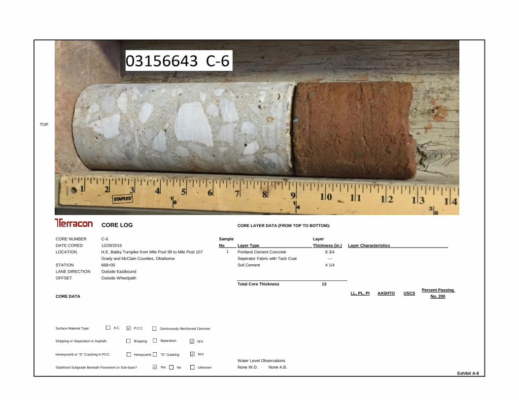
CORE LOG CORE LAYER DATA (FROM TOP TO BOTTOM):
CORE NUMBER C-6 Sample LayerDATE CORED 12/29/2015 No Thickness (in.)LOCATION H.E. Bailey Turnpike from Mile Post 99 to Mile Post 107 1 8 3/4
Grady and McClain Counties, Oklahoma ---STATION 668+00 4 1/4LANE DIRECTION Outside EastboundOFFSET Outside Wheelpath
Total Core Thickness 13
CORE DATA
Surface Material Type:
Stripping or Separation in Asphalt:
Honeycomb or "D" Cracking in PCC:
Water Level ObservationsNone W.D. None A.B.
Exhibit A-8
Layer Type Layer CharacteristicsPortland Cement ConcreteSeperator Fabric with Tack CoatSoil Cement
Stabilized Subgrade Beneath Pavement or Sub-base?
Percent PassingNo. 200
LL, PL, PI AASHTO USCS
A.C. P.C.C.
Stripping Separation N/A
Honeycomb "D" Cracking N/A
Continuously Reinforced Concrete
Yes No Unknown

TOP
CORE LOG CORE LAYER DATA (FROM TOP TO BOTTOM):
CORE NUMBER C-7 Sample LayerDATE CORED 12/29/2015 No Thickness (in.)LOCATION H.E. Bailey Turnpike from Mile Post 99 to Mile Post 107 1 9
Grady and McClain Counties, Oklahoma ---STATION 773+00 4 1/2LANE DIRECTION Outside EastboundOFFSET Outside Wheelpath
Total Core Thickness 13 1/2
CORE DATA
Surface Material Type:
Stripping or Separation in Asphalt:
Honeycomb or "D" Cracking in PCC:
Water Level ObservationsNone W.D. None A.B.
Exhibit A-9
Layer Type Layer CharacteristicsPortland Cement ConcreteSeperator Fabric with Tack CoatSoil Cement
Stabilized Subgrade Beneath Pavement or Sub-base?
Percent PassingNo. 200
LL, PL, PI AASHTO USCS
A.C. P.C.C.
Stripping Separation N/A
Honeycomb "D" Cracking N/A
Continuously Reinforced Concrete
Yes No Unknown

TOP
CORE LOG CORE LAYER DATA (FROM TOP TO BOTTOM):
CORE NUMBER C-8 Sample LayerDATE CORED 12/29/2015 No Thickness (in.)LOCATION H.E. Bailey Turnpike from Mile Post 99 to Mile Post 107 1 9
Grady and McClain Counties, Oklahoma ---STATION 878+00 3LANE DIRECTION Outside EastboundOFFSET Outside Wheelpath
Total Core Thickness 12
CORE DATA
Surface Material Type:
Stripping or Separation in Asphalt:
Honeycomb or "D" Cracking in PCC:
Water Level ObservationsNone W.D. None A.B.
Exhibit A-10
Layer Type Layer CharacteristicsPortland Cement ConcreteSeperator Fabric with Tack CoatSoil Cement
Stabilized Subgrade Beneath Pavement or Sub-base?
Percent PassingNo. 200
LL, PL, PI AASHTO USCS
A.C. P.C.C.
Stripping Separation N/A
Honeycomb "D" Cracking N/A
Continuously Reinforced Concrete
Yes No Unknown
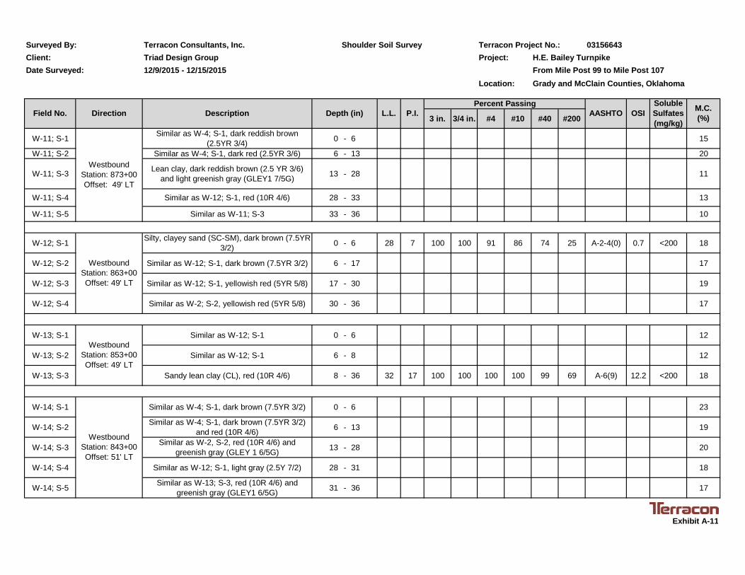
Terracon Consultants, Inc. Terracon Project No.: 03156643Project: H.E. Bailey Turnpike
From Mile Post 99 to Mile Post 107Location: Grady and McClain Counties, Oklahoma
3 in. 3/4 in. #4 #10 #40 #200
W-1; S-1 Similar as W-4; S-1, very dark brown (7.5YR2.5/2) 0 - 6 18
W-1; S-2 Similar as W-2; S-2 6 - 36 20
W-2; S-1 Similar as W-4; S-1, dark brown (7.5YR 3/3) 0 - 6 20
W-2; S-2 Lean clay with sand (CL), dark brown (7.5YR3/3) and yellowish red (5YR 5/8) 6 - 36 30 15 100 100 100 100 98 77 A-6(9) 12.0 <200 18
BULK 1 --- Lean clay with sand (CL), dark brown(7.5YR 3/3) and yellowish red (5YR 5/8) 6 - 36 32 18 100 100 100 99 97 72 A-6(10) 13.1
W-3; S-1 Similar as W-4; S-1, dark brown (7.5YR 3/2) 0 - 6 15
W-3; S-2 Similar as W-2; S-2 6 - 36 17
W-4; S-1 Clayey sand (SC), very dark brown (7.5YR2.5/2) 0 - 6 30 14 100 93 86 83 74 48 A-6(3) 7.3 <200 16
W-4; S-2 Similar as W-2; S-2, very dark brown (7.5 YR2.5/2) and yellowish red (5YR 4/6) 6 - 18 17
W-4; S-3 Similar as W-12; S-1, very dark brown (7.5YR2.5/2) 18 - 21 17
W-4; S-4 Similar as W-2; S-2, dark brown (7.5YR 3/4) 21 - 36 20
W-5; S-1 Similar as W-2; S-2, dark brown (7.5YR 3/3)and yellowish red (5YR 5/8) 0 - 6 17
W-5; S-2 Similar as W-2; S-2, yellowish red (5YR 4/6)and light brown (7.5YR 6/4) 6 - 36 19
W-6; S-1 Similar as W-4; S-1, very dark brown (7.5YR2.5/3) 0 - 6 34 16 100 100 92 88 80 48 A-6(4) 8.2 <200 22
W-6; S-2 Similar as W-2; S-2, reddish brown (5YR 4/4) 6 - 36 16
M.C.(%)
Exhibit A-11
SolubleSulfates(mg/kg)
OSIDirectionField No. P.I.L.L.
WestboundStation: 973+00Offset: 52' LT
WestboundStation: 963+00Offset: 65' LT
WestboundStation: 953+00Offset: 49' LT
WestboundStation: 933+00Offset: 49' LT
AASHTO
Surveyed By:Client:
Shoulder Soil SurveyTriad Design Group
WestboundStation: 923+00Offset: 47' LT
Percent Passing
Date Surveyed: 12/9/2015 - 12/15/2015
Depth (in)Description
WestboundStation: 943+00Offset: 49' LT

Terracon Consultants, Inc. Terracon Project No.: 03156643Project: H.E. Bailey Turnpike
From Mile Post 99 to Mile Post 107Location: Grady and McClain Counties, Oklahoma
3 in. 3/4 in. #4 #10 #40 #200
W-7; S-1 Similar as W-4; S-1, very dark brown (7.5YR2.5/3) and yellowish red (5YR 5/8) 0 - 6 16
W-7; S-2 Similar as W-2; S-2, light brown (7.5YR 6/3) 6 - 32 34 19 100 100 100 99 98 77 A-6(13) 14.4 <200 18
W-7; S-3 Similar as W-12; S-1, red (2.5YR 4/6) 32 - 36 17
W-8; S-1 Similar as W-4; S-1, dark brown (7.5YR 3/3)and yellowish red (5YR 5/8) 0 - 6 16
W-8; S-2 Similar as W-2; S-2, yellowish red (5YR 5/8) 6 - 15 15
W-8; S-3 Similar as W-12; S-1, yellowish red (5YR 5/8) 15 - 30 16
W-8; S-4 Similar as W-2; S-2, yellowish red (5YR 5/8) 30 - 36 18
W-9; S-1 Similar as W-4; S-1, very dark gray (5YR 3/1) 0 - 6 17
W-9; S-2 Similar as W-2; S-2, weak red (10R 4/4) 6 - 14 16
W-9; S-3 Similar as W-12; S-1, weak red (10R 4/4) 14 - 20 18
W-9; S-4 Similar as W-2; S-2, weak red (10R 4/4) 20 - 36 33 19 100 100 99 99 98 69 A-6(10) 13.2 <200 18
W-10; S-1 Similar as W-12; S-1, red (10R 4/6) 0 - 6 20
W-10; S-2 Similar as W-12; S-1, red (10R 4/6) 6 - 20 17
W-10; S-3 Similar as W-2; S-2, red (10YR 4/6) and darkbrown (7.5YR 3/3) 20 - 28 19
W-10; S-4 Similar as W-12; S-1, red (10R 4/6) 28 - 36 19
Surveyed By: Shoulder Soil SurveyClient: Triad Design GroupDate Surveyed: 12/9/2015 - 12/15/2015
OSISolubleSulfates(mg/kg)
M.C.(%)
WestboundStation: 913+00Offset: 49' LT
Field No. Direction Description Depth (in) L.L. P.I.Percent Passing
AASHTO
WestboundStation: 883+00Offset: 49' LT
Exhibit A-11
WestboundStation: 903+00Offset: 49' LT
WestboundStation: 893+00Offset: 49' LT
Terracon Consultants, Inc. Terracon Project No.: 03156643Project: H.E. Bailey Turnpike
From Mile Post 99 to Mile Post 107Location: Grady and McClain Counties, Oklahoma
3 in. 3/4 in. #4 #10 #40 #200
W-11; S-1 Similar as W-4; S-1, dark reddish brown(2.5YR 3/4) 0 - 6 15
W-11; S-2 Similar as W-4; S-1, dark red (2.5YR 3/6) 6 - 13 20
W-11; S-3 Lean clay, dark reddish brown (2.5 YR 3/6)and light greenish gray (GLEY1 7/5G) 13 - 28 11
W-11; S-4 Similar as W-12; S-1, red (10R 4/6) 28 - 33 13
W-11; S-5 Similar as W-11; S-3 33 - 36 10
W-12; S-1 Silty, clayey sand (SC-SM), dark brown (7.5YR3/2) 0 - 6 28 7 100 100 91 86 74 25 A-2-4(0) 0.7 <200 18
W-12; S-2 Similar as W-12; S-1, dark brown (7.5YR 3/2) 6 - 17 17
W-12; S-3 Similar as W-12; S-1, yellowish red (5YR 5/8) 17 - 30 19
W-12; S-4 Similar as W-2; S-2, yellowish red (5YR 5/8) 30 - 36 17
W-13; S-1 Similar as W-12; S-1 0 - 6 12
W-13; S-2 Similar as W-12; S-1 6 - 8 12
W-13; S-3 Sandy lean clay (CL), red (10R 4/6) 8 - 36 32 17 100 100 100 100 99 69 A-6(9) 12.2 <200 18
W-14; S-1 Similar as W-4; S-1, dark brown (7.5YR 3/2) 0 - 6 23
W-14; S-2 Similar as W-4; S-1, dark brown (7.5YR 3/2)and red (10R 4/6) 6 - 13 19
W-14; S-3 Similar as W-2, S-2, red (10R 4/6) andgreenish gray (GLEY 1 6/5G) 13 - 28 20
W-14; S-4 Similar as W-12; S-1, light gray (2.5Y 7/2) 28 - 31 18
W-14; S-5 Similar as W-13; S-3, red (10R 4/6) andgreenish gray (GLEY1 6/5G) 31 - 36 17
Surveyed By: Shoulder Soil SurveyClient: Triad Design GroupDate Surveyed: 12/9/2015 - 12/15/2015
Field No. Direction Description Depth (in) L.L. P.I.Percent Passing
AASHTO
WestboundStation: 843+00Offset: 51' LT
Exhibit A-11
OSISolubleSulfates(mg/kg)
M.C.(%)
WestboundStation: 873+00Offset: 49' LT
WestboundStation: 863+00Offset: 49' LT
WestboundStation: 853+00Offset: 49' LT

Terracon Consultants, Inc. Terracon Project No.: 03156643Project: H.E. Bailey Turnpike
From Mile Post 99 to Mile Post 107Location: Grady and McClain Counties, Oklahoma
3 in. 3/4 in. #4 #10 #40 #200
W-15; S-1 Similar as W-12; S-1 0 - 6 15
W-15; S-2 Sandy lean clay (CL), red (10R 4/6) 6 - 36 25 8 100 100 100 100 99 59 A-4(2) 6.2 <200 18
BULK 2 --- Silty sand (SM), red (10R 4/6) 6 - 36 22 3 100 100 100 100 99 40 A-4(0) 1.3
W-16; S-1 Similar as W-12; S-1 0 - 6 12
W-16; S-2 Similar as W-18; S-2, dusky red (10R 3/4) 6 - 9 15
W-16; S-3 Similar as W-15; S-2, red (10 R 4/8) 9 - 20 15
W-16; S-4 Similar as W-15; S-2 20 - 36 25 8 100 100 99 97 95 61 A-4(2) 6.5 <200 14
W-17; S-1 Similar as W-12; S-1 0 - 6 13
W-17; S-2 Similar as W-15; S-2, red (2.5YR 4/6) 6 - 13 18
W-17; S-3 Similar as W-15; S-2 13 - 36 18
W-18; S-1 Similar as W-12; S-1, dark reddish brown(2.5YR 3/3) and red (2.5YR 4/6) 0 - 6 16
W-18; S-2 Silty clayey sand (SC-SM), red (2.5YR 4/8) 6 - 20 23 7 100 100 98 97 93 49 A-4(1) 4.0 <200 14
W-18; S-3 Similar as W-18; S-2 20 - 30 14
(Hand Auger Refusal at 30 inches - Apparent Weathered Sandstone)
W-19; S-1 Similar as W-12; S-1, dark brown (7.5YR 3/2)and red (2.5YR 4/6) 0 - 6 13
W-19; S-2 Similar as W-15; S-2 6 - 36 15
Surveyed By: Shoulder Soil SurveyClient: Triad Design GroupDate Surveyed: 12/9/2015 - 12/15/2015
Field No. Direction Description Depth (in) L.L. P.I.Percent Passing
AASHTO OSISolubleSulfates(mg/kg)
Exhibit A-11
WestboundStation: 823+00Offset: 49' LT
M.C.(%)
WestboundStation: 833+00Offset: 49' LT
WestboundStation: 813+00Offset: 51' LT
WestboundStation: 803+00Offset: 49' LT
WestboundStation: 793+00Offset: 49' LT

Terracon Consultants, Inc. Terracon Project No.: 03156643Project: H.E. Bailey Turnpike
From Mile Post 99 to Mile Post 107Location: Grady and McClain Counties, Oklahoma
3 in. 3/4 in. #4 #10 #40 #200
W-20; S-1 Similar as W-12, S-1 0 - 6 14
W-20; S-2 Similar as W-18; S-2, dark brown (7.5YR 3/3) 6 - 36 25 7 100 100 100 99 99 36 A-4(0) 1.6 <200 16
W-21; S-1 Similar as W-12; S-1 0 - 6 25 7 100 100 89 84 77 31 A-2-4(0) 1.1 <200 15
W-21; S-2 Similar as W-15; S-2, red (2.5YR 4/6) 6 - 36 11
W-22; S-1 Similar as W-12; S-1 0 - 6 13
W-22; S-2 Similar as W-15; S-2, reddish brown (2.5YR4/4) 6 - 21 16
W-22; S-3 Similar as W-15; S-2, red (2.5YR 4/8) and darkreddish brown (2.5YR 3/3) 21 - 36 17
W-23; S-1 Simiilar as W-12; S-1, dark brown (7.5YR 3/4)and red (2.5YR 4/6) 0 - 6 17
W-23; S-2 Similar as W-15; S-2, red (2.5YR 4/6) 6 - 21 16
W-23; S-3 Similar as W-15; S-2, red (2.5YR 4/6) 21 - 36 26 12 100 100 100 99 98 59 A-6(4) 7.9 <200 16
W-24; S-1 Similar as W-12; S-1 0 - 6 12
W-24; S-2 Similar as W-15; S-2, red (2.5YR 4/6) 6 - 36
Surveyed By: Shoulder Soil SurveyClient: Triad Design GroupDate Surveyed: 12/9/2015 - 12/15/2015
Field No. Direction Description Depth (in) L.L. P.I.Percent Passing
AASHTO
WestboundStation: 753+00Offset: 49' LT
WestboundStation: 743+00Offset: 49' LT
Exhibit A-11
OSISolubleSulfates(mg/kg)
M.C.(%)
WestboundStation: 783+00Offset: 49' LT
WestboundStation: 773+00Offset: 49' LT
WestboundStation: 763+06Offset: 50' LT

Terracon Consultants, Inc. Terracon Project No.: 03156643Project: H.E. Bailey Turnpike
From Mile Post 99 to Mile Post 107Location: Grady and McClain Counties, Oklahoma
3 in. 3/4 in. #4 #10 #40 #200
W-25; S-1 Similar as W-12; S-1, dark brown (7.5YR 3/3)and red (2.5YR 4/6) 0 - 6 20 4 100 100 96 94 89 25 A-2-4(0) 0.4 <200 12
W-25; S-2 Similar as W-15; S-2, red (2.5YR 4/6) 6 - 18 15
W-25; S-3 Similar as W-33; S-2, red (2.5YR 5/6) 18 - 24 12
W-25; S-4 Similar as W-15; S-2, red (2.5YR 4/6) and lightgreenish gray (GLEY1 7/5G) 24 - 36 12
W-26; S-1 Similar as W-12; S-1, dark brown (7.5YR 3/4) 0 - 6 18
W-26; S-2 Similar as W-15; S-2, red (2.5YR 4/6) 6 - 21 17
W-26; S-3 Similar as W-28; S-3, red (2.5YR 4/6) 21 - 36 15
W-27; S-1 Similar as W-12; S-1 0 - 6 15
W-27; S-2 Similar as W-12; S-1 6 - 12 14
W-27; S-3 Similar as W-15; S-2, weak red (10R 4/3) 12 - 25 16
W-27; S-4 Similar as W-28; S-3, red (2.5YR 4/6) 25 - 32 19
W-27; S-5 Similar as W-15; S-2, dark reddish brown(2.5YR 3/4) 32 - 36 21
W-28; S-1 Similar as W-12; S-1, dark reddish brown(2.5YR 3/4) 0 - 6 13
W-28; S-2 Similar as W-28; S-3, red (2.5YR 4/6) 6 - 21 13
W-28; S-3 Silty sand (SM), light red (2.5YR 6/6) 21 - 36 21 2 100 100 100 100 99 19 A-2-4(0) 0.0 <200 13
(Water encountered after boring at approximately 35 inches)
Surveyed By: Shoulder Soil SurveyClient: Triad Design GroupDate Surveyed: 12/9/2015 - 12/15/2015
Field No. Direction Description Depth (in) L.L. P.I.Percent Passing
AASHTO
WestboundStation: 703+00Offset: 49' LT
Exhibit A-11
OSISolubleSulfates(mg/kg)
M.C.(%)
WestboundStation: 733+00Offset: 49' LT
WestboundStation: 723+00Offset: 49' LT
WestboundStation: 713+00Offset: 50' LT

Terracon Consultants, Inc. Terracon Project No.: 03156643Project: H.E. Bailey Turnpike
From Mile Post 99 to Mile Post 107Location: Grady and McClain Counties, Oklahoma
3 in. 3/4 in. #4 #10 #40 #200
W-29; S-1 Similar as W-12; S-1 0 - 6 14
W-29; S-2 Similar as W-12; S-1 6 - 36 22 5 100 100 100 99 97 35 A-2-4(0) 1.0 <200 13
W-30; S-1 Similar as W-12; S-1, dark reddish brown(2.5YR 3/4) and red (2.5YR 4/6) 0 - 6 10
W-30; S-2 Similar as W-12; S-1, red (2.5YR 4/6) 6 - 14 39
W-30; S-3 Similar as W-15; S-2, red (2.5YR 4/6) 14 - 36 12
W-31; S-1 Similar as W-12; S-1, dark reddish brown(2.5YR 3/4) 0 - 6 23 5 100 95 72 68 62 21 A-2-4(0) 0.3 <200 13
W-31; S-2 Similar as W-28; S3, red (2.5YR 4/6) 6 - 16 13
W-31; S-3 Similar as W-28; S3, red (2.5YR 4/6) 16 - 18 9
(Hand Auger Refusal at 18 inches - Apparent Weathered Sandstone)
W-32; S-1 Similar as W-12; S-1, dark reddish brown(2.5YR 3/4) and very dark brown (7.5YR 2.5/2) 0 - 6 10
W-32; S-2 Similar as W-28; S3, red (2.5YR 4/6) 6 - 36 11
W-33; S-1 Similar as W-12; S-1, dark reddish brown(2.5YR 3/4) 0 - 6 11
W-33; S-2 Poorly graded sand with silt (SP-SM), red(2.5YR 4/6) 6 - 36 NP NP 100 100 100 100 99 11 A-2-4(0) 0.0 <200 9
W-34; S-1 Similar as W-12; S-1, dark reddish brown(2.5YR 3/4) 0 - 6 13
W-34; S-2 Similar as W-18; S-2, very dark brown (7.5YR2.5/3) 6 - 25 17
W-34; S-3 Similar as W-18; S-2 25 - 36 23 7 100 100 100 100 99 44 A-4(0) 3.1 <200 22
Surveyed By: Shoulder Soil SurveyClient: Triad Design GroupDate Surveyed: 12/9/2015 - 12/15/2015
Field No. Direction Description Depth (in) L.L. P.I.Percent Passing
AASHTO OSISolubleSulfates(mg/kg)
Exhibit A-11
WestboundStation: 643+06Offset: 49' LT
M.C.(%)
WestboundStation: 693+00Offset: 49' LT
WestboundStation: 683+00Offset: 49' LT
WestboundStation: 663+00Offset: 49' LT
WestboundStation: 653+00Offset: 49' LT
WestboundStation: 673+06Offset: 49' LT

Terracon Consultants, Inc. Terracon Project No.: 03156643Project: H.E. Bailey Turnpike
From Mile Post 99 to Mile Post 107Location: Grady and McClain Counties, Oklahoma
3 in. 3/4 in. #4 #10 #40 #200
W-35; S-1 Similar as W-12; S-1, dark reddish brown(2.5YR 3/4) 0 - 6 15
W-35; S-2 Similar as W-18; S-2, red(2.5YR 4/6) 6 - 19 15
W-35; S-3 Similar as W-15; S-2, red (2.5YR 4/6) and lightgreenish gray (GLEY1 3/5G) 19 - 34 14
W-35; S-4 Similar as W-18; S-2, red(2.5YR 4/6) 34 - 35 9
(Hand Auger Refusal at 35 inches - Apparent Weathered Sandstone)
W-36; S-1 Similar as W-12; S-1, dark reddish brown(2.5YR 3/4) 0 - 6 13
W-36; S-2 Similar as W-15; S-2, dark red (2.5YR 3/6) 6 - 12 13
W-36; S-3 Similar as W-33; S-2, red (2.5YR 4/6) 12 - 32 13
(Hand Auger Refusal at 32 inches - Apparent Weathered Sandstone)
W-37; S-1 Similar as W-18; S-2, dark brown (7.5YR 3/2)and red (2.5YR 4/6) 0 - 6 24 6 100 100 100 98 93 39 A-4(0) 1.9 <200 16
W-37; S-2 Similar as W-12; S-1, dark reddish brown(2.5YR 3/4) 6 - 26 15
W-37; S-3 Similar as W-33; S-2, red (2.5YR 4/6) 26 - 36 17
W-38; S-1 Similar as W-12; S-1, dark brown (7.5YR 3/2) 0 - 6 13
W-38; S-2 Similar as W-15; S-2, dark red (2.5YR 3/6) 6 - 14 12
W-38; S-3 Similar as W-33; S-2, red (2.5YR 4/6) 14 - 36 15
Surveyed By: Shoulder Soil SurveyClient: Triad Design GroupDate Surveyed: 12/9/2015 - 12/15/2015
Field No. Direction Description Depth (in) L.L. P.I.Percent Passing
AASHTO
WestboundStation: 603+00Offset: 50' LT
Exhibit A-11
OSISolubleSulfates(mg/kg)
M.C.(%)
WestboundStation: 633+00Offset: 49' LT
WestboundStation: 623+00Offset: 49' LT
WestboundStation: 613+06Offset: 49' LT

Terracon Consultants, Inc. Terracon Project No.: 03156643Project: H.E. Bailey Turnpike
From Mile Post 99 to Mile Post 107Location: Grady and McClain Counties, Oklahoma
3 in. 3/4 in. #4 #10 #40 #200
W-39; S-1 Simiilar as W-18; S-2, dark brown (7.5YR 3/3) 0 - 6 17
W-39; S-2 Similar as W-15; S-2, dark red (2.5YR 3/6) 6 - 12 16
W-39; S-3 Similar as W-12; S-1, dark reddish brown(2.5YR 3/4) 12 - 18 16
W-39; S-4 Similar as W-12; S-1, dark reddish brown(2.5YR 3/4) 18 - 22 14
W-39; S-5 Similar as W-4; S-1, dark reddish brown(2.5YR 3/3) 22 - 36 39 22 100 100 100 100 100 49 A-6(7) 10.8 <200 14
W-40; S-1 Similar as W-12; S-1, dark brown (7.5YR 3/3) 0 - 6 13
W-40; S-2 Similar as W-15; S-2, dark red (2.5YR 4/6) 6 - 36 15
W-41; S-1 Similar as W-12; S-1, dark brown (7.5YR 3/3) 0 - 6 15
W-41; S-2 Lean clay (CL), red (2.5YR 4/6) 6 - 32 28 14 100 100 97 96 95 88 A-6(10) 11.2 <200 16
(Hand Auger Refusal at 32 inches - Apparent Weathered Shaley Clay)
W-42; S-1 Similar as W-12; S-1, red (2.5YR 4/6) 0 - 6 16
W-42; S-2 Similar as W-15; S-2, dark red (2.5YR 4/6) 6 - 24 17
W-42; S-3 Similar as W-13; S-3, dark reddish brown(2.5YR 3/4) 24 - 36 28 14 100 100 99 98 96 53 A-6(4) 8.0 <200 14
Surveyed By: Shoulder Soil SurveyClient: Triad Design GroupDate Surveyed: 12/9/2015 - 12/15/2015
Field No. Direction Description Depth (in) L.L. P.I.Percent Passing
AASHTO
WestboundStation: 563+00Offset: 49' LT
Exhibit A-11
OSISolubleSulfates(mg/kg)
M.C.(%)
WestboundStation: 593+00Offset: 49' LT
WestboundStation: 583+00Offset: 49' LT
WestboundStation: 573+06Offset: 49' LT

Terracon Consultants, Inc. Terracon Project No.: 03156643Project: H.E. Bailey Turnpike
From Mile Post 99 to Mile Post 107Location: Grady and McClain Counties, Oklahoma
3 in. 3/4 in. #4 #10 #40 #200
W-43; S-1 Similar as W-12; S-1, dark reddish brown(2.5YR 3/4) 0 - 6 18
W-43; S-2 Similar as W-12; S-1, dark reddish brown(2.5YR 3/4) 6 - 8 18
W-43; S-3 Similar as W-13; S-3, dark red (2.5YR 3/6) andgreenish gray (GLEY1 6/5G) 8 - 36 25 12 100 100 96 94 89 57 A-6(4) 7.5 200 19
W-44; S-1 Similar as W-12; S-1, dark reddish brown(2.5YR 3/4) 0 - 6 14
W-44; S-2 Similar as W-12; S-1, dark reddish brown(2.5YR 3/4) 6 - 16 13
W-44; S-3 Similar as W-33; S-2, red 2.5YR (4/6) 16 - 20 12
(Hand Auger Refusal at 32 inches - Apparent Weathered Sandstone)
Surveyed By: Shoulder Soil SurveyClient: Triad Design GroupDate Surveyed: 12/9/2015 - 12/15/2015
Field No. Direction Description Depth (in) L.L. P.I.Percent Passing
AASHTO
WestboundStation: 543+00Offset: 49' LT
Exhibit A-11
OSISolubleSulfates(mg/kg)
M.C.(%)
WestboundStation: 553+00Offset: 49' LT

Terracon Consultants, Inc. Terracon Project No.: 03156643Project: H.E. Bailey Turnpike
From Mile Post 99 to Mile Post 107Location: Grady and McClain Counties, Oklahoma
3 in. 3/4 in. #4 #10 #40 #200
E-1; S-1 Similar as W-12; S-1, dark red (2.5YR 4/6) 0 - 6 17
E-1; S-2 Similar as W-18; S-2, red (2.5YR 4/6) 6 - 36 23 6 100 100 98 97 95 47 A-4(0) 3.3 <200 16
E-2; S-1 Similar as W-12; S-1, dark red (2.5YR 3/6) 0 - 6 18
E-2; S-2 Similar as W-18; S-2, red (2.5YR 4/6) 6 - 36 15
E-3; S-1 Similar as W-18; S-2, red (2.5YR 4/6) 0 - 6 22 5 100 100 98 97 93 38 A-4(0) 1.5 <200 16
E-3; S-2 Similar as W-28; S-3, red (2.5YR 4/6) 6 - 12 15
E-3; S-3 Similar as W-18; S-2, red (2.5YR 4/6) 12 - 29 19
E-3; S-4 Similar as W-28; S-3, red (2.5YR 4/6) 29 - 36 14
E-4; S-1 Similar as W-18; S-2, red (2.5YR 4/6) 0 - 6 12
E-4; S-2 Similar as W-18; S-2, dark red (2.5YR 3/6) 6 - 18 16
E-4; S-3 Similar as W-28; S-3, dark red (2.5YR 3/6) 18 - 36 16
E-5; S-1 Similar as W-18; S-2, red (2.5YR 4/6) 0 - 6 10
E-5; S-2 Similar as W-28; S-3, dark red (2.5YR 3/6) 6 - 18 13
E-5; S-3 Similar as W-2; S-2, dark red (2.5YR 3/6) 18 - 36 32 17 100 100 99 98 96 74 A-6(10) 13.0 <200 18
Surveyed By: Shoulder Soil SurveyClient: Triad Design GroupDate Surveyed: 12/9/2015 - 12/15/2015
Field No. Direction Description Depth (in) L.L. P.I.Percent Passing
AASHTO
EastboundStation: 568+00Offset: 49' RT
EastboundStation: 578+00Offset: 49' LT
Exhibit A-11
OSISolubleSulfates(mg/kg)
M.C.(%)
EastboundStation: 537+00Offset: 49' RT
EastboundStation: 548+00Offset: 49' RT
EastboundStation: 558+00Offset: 49' RT

Terracon Consultants, Inc. Terracon Project No.: 03156643Project: H.E. Bailey Turnpike
From Mile Post 99 to Mile Post 107Location: Grady and McClain Counties, Oklahoma
3 in. 3/4 in. #4 #10 #40 #200
E-6; S-1 Similar as W-18; S-2, red (2.5YR 4/6) 0 - 6 17
E-6; S-2 Similar as W-18; S-2, dark red (2.5YR 3/6) 6 - 15 13
E-6; S-3 Similar as W-28; S-3, dark red (2.5YR 3/6) 15 - 19 15
E-6; S-4 Similar as W-18; S-2, dark red (2.5YR 3/6) 19 - 25 17
E-6; S-5 Similar as W-28; S-3, red (2.5YR 4/6) 25 - 36 14
E-7; S-1 Similar as W-18; S-2, red (2.5YR 4/6) 0 - 6 14
E-7; S-2 Similar as W-28; S-3, dark red (2.5YR 3/6) 6 - 12 15
E-7; S-3 Similar as W-18; S-2, red (2.5YR 4/6) 12 - 17 17
E-7; S-4 Similar as W-28; S-3, dark red (2.5YR 3/6) 17 - 27 21 6 100 100 99 98 95 37 A-4(0) 1.5 <200 14
E-7; S-5 Similar as W-33; S-2, dark red (2.5YR 3/6) 27 - 36 13
E-8; S-1 Similar as W-18; S-2, red (2.5YR 4/6) 0 - 6 14
E-8; S-2 Similar as W-28; S-3, dark red (2.5YR 3/6) 6 - 12 15
E-8; S-3 Similar as W-33; S-2, dark red (2.5YR 3/6) 12 - 27 15(Hand Auger Refusal at 27 inches - Apparent Weathered Sandstone)
E-9; S-1 Similar as W-18; S-2, very dark brown (7.5YR2.5/2) and red (2.5YR 4/6) 0 - 6 19
E-9; S-2 Similar as W-28; S-3, red (2.5YR 4/6) 6 - 36 20 1 100 100 90 88 85 35 A-2-4(0) 0.2 <200 14
BULK 3 --- Silty Sand (SM), red (2.5YR 4/6) 6 - 36 NP NP 100 100 99 99 98 17 A-2-4(0) 0.0
Surveyed By: Shoulder Soil SurveyClient: Triad Design GroupDate Surveyed: 12/9/2015 - 12/15/2015
OSISolubleSulfates(mg/kg)
M.C.(%)
EastboundStation: 608+00Offset: 49' RT
Field No. Direction Description Depth (in) L.L. P.I.Percent Passing
AASHTO
EastboundStation: 618+00Offset: 49' RT
Exhibit A-11
EastboundStation: 588+00Offset: 50' RT
EastboundStation: 598+00Offset: 50' RT

Terracon Consultants, Inc. Terracon Project No.: 03156643Project: H.E. Bailey Turnpike
From Mile Post 99 to Mile Post 107Location: Grady and McClain Counties, Oklahoma
3 in. 3/4 in. #4 #10 #40 #200
E-10; S-1 Similar as W-18; S-2, red (2.5YR 4/6) 0 - 6 15
E-10; S-2 Similar as W-28; S-3, reddish brown (2.5YR4/4) 6 - 18 16
E-10; S-3 Similar as W-33; S-2, red (2.5YR 4/6) 18 - 36 17
E-11; S-1 Similar as W-18; S-2, red (2.5YR 4/6) 0 - 6 17
E-11; S-2 Similar as W-18; S-2, red (2.5YR 4/6) 6 - 9 18
E-11; S-3 Similar as W-18; S-2, red (2.5YR 4/6) 9 - 27 21 6 100 100 99 98 97 39 A-4(0) 1.9 <200 16
E-11; S-4 Similar as W-33; S-2, red (2.5YR 4/6) 27 - 28 12
(Hand Auger Refusal at 28 inches - Apparent Weathered Sandstone)
E-12; S-1 Similar as W-18; S-2, red (2.5YR 4/6) 0 - 6 14
E-12; S-2 Similar as W-33; S-2, red (2.5YR 4/6) 6 - 36 13
E-13; S-1 Similar as W-12; S-1 0 - 6 22 5 100 100 95 93 90 35 A-2-4(0) 1.0 <200 15
E-13; S-2 Similar as W-28; S-3, red (2.5YR 4/6) 6 - 36 18
E-14; S-1 Similar as W-18; S-2, red (2.5YR 4/6) 0 - 6 15
E-14; S-2 Similar as W-28; S-3, red (2.5YR 4/6) 6 - 24 16
E-14; S-3 Similar as W-33; S-2, red (2.5YR 4/6) 24 - 36 17
Surveyed By: Shoulder Soil SurveyClient: Triad Design GroupDate Surveyed: 12/9/2015 - 12/15/2015
Field No. Direction Description Depth (in) L.L. P.I.Percent Passing
AASHTO
EastboundStation: 658+00Offset: 49' RT
EastboundStation: 668+00Offset: 49' RT
Exhibit A-11
OSISolubleSulfates(mg/kg)
M.C.(%)
EastboundStation: 628+00Offset: 49' RT
EastboundStation: 648+00Offset: 49' RT
EastboundStation: 638+00Offset: 49' RT

Terracon Consultants, Inc. Terracon Project No.: 03156643Project: H.E. Bailey Turnpike
From Mile Post 99 to Mile Post 107Location: Grady and McClain Counties, Oklahoma
3 in. 3/4 in. #4 #10 #40 #200
E-15; S-1 Similar as W-28; S-3, red (2.5YR 4/6) 0 - 6 14
E-15; S-2 Similar as W-28; S-3, red (2.5YR 4/6) 6 - 12 14
E-15; S-3 Similar as W-28; S-3, red (2.5YR 4/6) 12 - 24 15
E-15; S-4 Silt with sand (SM) 24 - 36 24 3 100 100 100 100 100 79 A-4(1) 6.0 <200 14
E-16; S-1 Similar as W-18; S-2, red (2.5YR 4/6) 0 - 6 16
E-16; S-2 Similar as W-28; S-3, red (2.5YR 4/6) 6 - 36 15
E-17; S-1 Similar as W-12; S-1 0 - 6 22 5 100 90 83 83 74 28 A-2-4(0) 0.7 <200 16
E-17; S-2 Similar as W-28; S-3, red (2.5YR 4/4) 6 - 12 14
E-17; S-3 Similar as W-33; S-2, dark reddish brown(2.5YR 4/4) 12 - 28 15
E-17; S-4 Similar as W-18; S-2, red (2.5YR 4/6) 28 - 36 18
E-18; S-1 Similar as W-18; S-2, red (2.5YR 4/6) 0 - 6 15
E-18; S-2 Similar as W-33; S-2, red (2.5YR 4/6) 6 - 36 15
E-19; S-1 Similar as W-18; S-2, red (2.5YR 4/6) 0 - 6 15
E-19; S-2 Similar as W-28; S-3, red (2.5YR 4/6) 6 - 15 16
E-19; S-3 Poorly graded sand (SP), red (2.5YR 4/6) 15 - 36 32 18 100 100 100 100 99 3 A-2-6(0) 4.0 <200 19
Surveyed By: Shoulder Soil SurveyClient: Triad Design GroupDate Surveyed: 12/9/2015 - 12/15/2015
Field No. Direction Description Depth (in) L.L. P.I.Percent Passing
AASHTO
EastboundStation: 708+00Offset: 49' RT
EastboundStation: 718+00Offset: 49' RT
Exhibit A-11
OSISolubleSulfates(mg/kg)
M.C.(%)
EastboundStation: 678+00Offset: 49' RT
EastboundStation: 698+00Offset: 49' RT
EastboundStation: 688+00Offset: 49' RT

Terracon Consultants, Inc. Terracon Project No.: 03156643Project: H.E. Bailey Turnpike
From Mile Post 99 to Mile Post 107Location: Grady and McClain Counties, Oklahoma
3 in. 3/4 in. #4 #10 #40 #200
E-20; S-1 Similar as W-18; S-2, redddish brown (2.5YR4/4) 0 - 6 19
E-20; S-2 Similar as W-18; S-2, redddish brown (2.5YR4/4) 6 - 20 19
E-20; S-3 Similar as W-41; S-2, reddish brown (2.5YR4/4) 20 - 36 20
E-21; S-1 Similar as W-28; S-3, redddish brown (2.5YR4/4) 0 - 6 12
E-21; S-2 Similar as W-28; S-3, reddish brown (2.5YR4/8) 6 - 36 NP NP 100 100 100 99 99 37 A-4(0) 0.0 <200 17
E-22; S-1 Similar as W-18; S-2, red (2.5YR 4/6) 0 - 6 17
E-22; S-2 Similar as W-28; S-3, red (2.5YR 4/6) 6 - 24 18
E-22; S-3 Similar as W-18; S-2, red (2.5YR 4/6) 24 - 36 15
E-23; S-1 Similar as W-28; S-3, dark reddish brown(2.5YR 3/4) 0 - 6 11
E-23; S-2 Similar as W-33; S-2, red (2.5YR 4/8) 6 - 36 16
E-24; S-1 Similar as W-12; S-1, dark reddish brown(2.5YR 3/4) 0 - 6 27 8 100 89 83 79 72 28 A-2-4(0) 1.0 <200 15
E-24; S-2 Similar as W-28; S-3, dark reddish brown(2.5YR 3/4) 6 - 12 14
E-24; S-3 Similar as W-33; S-2, red (2.5YR 4/6) 12 - 20 16
E-24; S-4 Similar as W-18; S-2, red (2.5YR 4/6) 20 - 26 17
E-24; S-5 Similar as W-33; S-2, red (2.5YR 4/6) 26 - 36 14
Surveyed By: Shoulder Soil SurveyClient: Triad Design GroupDate Surveyed: 12/9/2015 - 12/15/2015
Field No. Direction Description Depth (in) L.L. P.I.Percent Passing
AASHTO
EastboundStation: 758+50Offset: 50' RT
EastboundStation: 768+00Offset: 49' RT
Exhibit A-11
OSISolubleSulfates(mg/kg)
M.C.(%)
EastboundStation: 728+00Offset: 49' RT
EastboundStation: 738+00Offset: 49' RT
EastboundStation: 748+00Offset: 49' RT

Terracon Consultants, Inc. Terracon Project No.: 03156643Project: H.E. Bailey Turnpike
From Mile Post 99 to Mile Post 107Location: Grady and McClain Counties, Oklahoma
3 in. 3/4 in. #4 #10 #40 #200
E-25; S-1 Similar as W-28; S-3, dark reddish brown(2.5YR 3/4) 0 - 6 17
E-25; S-2 Similar as W-28; S-3, dark reddish brown(2.5YR 4/6) 6 - 12 16
E-25; S-3 Similar as W-33; S-2, red (2.5YR 4/6) 12 - 36 12
E-26; S-1 Similar as W-12; S-1, reddish brown (2.5YR4/4) 0 - 6 16
E-26; S-2 Similar as W-12; S-1, red (2.5YR 4/6) and darkbrown (7.5YR 3/4) 6 - 11 18
E-26; S-3 Similar as W-18, S-2, red (2.5YR 4/6) 11 - 36 24 6 100 100 100 99 98 47 A-4(0) 3.4 <200 19
E-27; S-1 Similar as W-18, S-2, reddish brown (2.5YR4/4) 0 - 6 17
E-27; S-2 Similar as W-28; S-3, red (2.5YR 4/6) 6 - 26 16
E-27; S-3 Similar as W-33; S-2, red (2.5YR 4/6) 26 - 30 13
(Hand Auger Refusal at 30 inches - Apparent Weathered Sandstone)
E-28; S-1 Similar as W-28; S-3, reddish brown (2.5YR4/4) 0 - 6 15
E-28; S-2 Similar as W-15; S-2, red (2.5YR 4/6) 6 - 36 25 8 100 100 97 96 95 50 A-4(1) 4.7 <200 16
E-29; S-1 Similar as W-12; S-1, dark brown (7.5YR 3/4) 0 - 6 15
E-29; S-2 Similar as W-18, S-2, red (2.5YR 4/6) 6 - 16 15
E-29; S-3 Similar as W-18, S-2, red (2.5YR 4/6) 16 - 26 20
E-29; S-4 Similar as W-33; S-2, red (2.5YR 4/6) 26 - 34 7
(Hand Auger Refusal at 34 inches - Apparent Weathered Sandstone)
Surveyed By: Shoulder Soil SurveyClient: Triad Design GroupDate Surveyed: 12/9/2015 - 12/15/2015
Field No. Direction Description Depth (in) L.L. P.I.Percent Passing
AASHTO
EastboundStation: 808+00Offset: 49' RT
EastboundStation: 818+00Offset: 49' RT
Exhibit A-11
OSISolubleSulfates(mg/kg)
M.C.(%)
EastboundStation: 778+00Offset: 49' RT
EastboundStation: 798+00Offset: 49' RT
EastboundStation: 788+00Offset: 49' RT

Terracon Consultants, Inc. Terracon Project No.: 03156643Project: H.E. Bailey Turnpike
From Mile Post 99 to Mile Post 107Location: Grady and McClain Counties, Oklahoma
3 in. 3/4 in. #4 #10 #40 #200
E-30; S-1 Similar as W-12; S-1, reddish brown (2.5YR4/4) 0 - 6 23 5 100 100 91 87 81 29 A-2-4(0) 0.7 <200 16
E-30; S-2 Similar as W-33; S-2, red (2.5YR 4/6) 6 - 12 15
E-30; S-3 Similar as W-33; S-2, red (2.5YR 4/6) 12 - 15 15
(Hand Auger Refusal at 15 inches - Apparent Weathered Sandstone)
E-31; S-1 Similar as W-12; S-1, reddish brown (2.5YR4/4) 0 - 6 14
E-31; S-2 Similar as W-28; S-3, red (2.5YR 4/6) 6 - 22 12
E-31; S-3 Similar as W-18, S-2, red (2.5YR 4/6) 22 - 35 19
E-31; S-4 Similar as W-28; S-3, red (2.5YR 4/6) 35 - 36 23(Water was encountered at 35 inches)
E-32; S-1 Similar as W-18, S-2, red (2.5YR 4/6) and darkbrown (7.5YR 3/4) 0 - 6 14
E-32; S-2 Similar as W-28; S-3, red (2.5YR 4/8) 6 - 12 18
E-32; S-3 Similar as W-13; S-3, red (2.5YR 4/6) 12 - 24 28 11 100 87 83 81 78 49 A-6(2) 6.3 <200 19
E-32; S-4 Similar as W-28; S-3, red (2.5YR 4/6) 24 - 33 14
E-32; S-5 Similar as W-13; S-3, red (2.5YR 4/6) 33 - 36 15
E-33; S-1 Similar as W-12; S-1, reddish brown (2.5YR4/4) 0 - 6 16
E-33; S-2 Similar as W-18, S-2, red (2.5YR 4/6) 6 - 27 15
E-33; S-3 Similar as W-28; S-3, red (2.5YR 4/6) 27 - 36 12
Surveyed By: Shoulder Soil SurveyClient: Triad Design GroupDate Surveyed: 12/9/2015 - 12/15/2015
Field No. Direction Description Depth (in) L.L. P.I.Percent Passing
AASHTO
EastboundStation: 858+00Offset: 49' RT
Exhibit A-11
OSISolubleSulfates(mg/kg)
M.C.(%)
EastboundStation: 828+00Offset: 49' RT
EastboundStation: 838+00Offset: 49' RT
EastboundStation: 848+00Offset: 49' RT

Terracon Consultants, Inc. Terracon Project No.: 03156643Project: H.E. Bailey Turnpike
From Mile Post 99 to Mile Post 107Location: Grady and McClain Counties, Oklahoma
3 in. 3/4 in. #4 #10 #40 #200
E-34; S-1 Similar as W-28; S-3, reddish brown (2.5YR4/4) 0 - 6 15
E-34; S-2 Similar as W-28; S-3, red (2.5YR 4/6) 6 - 19 13
(Hand Auger Refusal at 19 inches - Apparent Weathered Sandstone)
E-35; S-1 Similar as W-18, S-2, red (2.5YR 4/6) anddark brown (7.5YR 3/4) 0 - 6 19
E-35; S-2 Similar as W-13; S-3, red (2.5YR 4/8) 6 - 36 29 14 100 100 100 95 89 47 A-6(3) 7.0 <200 18
BULK 4 --- Sandy lean clay (CL), red (2.5YR 4/8) 6 - 36 39 21 100 100 100 100 98 60 A-6(10) 13.3
E-36; S-1 Similar as W-18, S-2, dark reddish brown(2.5YR 3/3) 0 - 6 15
E-36; S-2 Similar as W-18, S-2, red (2.5YR 4/6) 6 - 11 13
E-36; S-3 Similar as W-28; S-3, red (2.5YR 4/6) 11 - 20 14
(Hand Auger Refusal at 20 inches - Apparent Weathered Sandstone)
E-37; S-1 Similar as W-28; S-3, red (2.5YR 4/6) 0 - 6 15
E-37; S-2 Similar as W-28; S-3, red (2.5YR 4/6) 6 - 24 14
E-37; S-3 Similar as W-18, S-2, red (2.5YR 4/6) 24 - 36 17
Surveyed By: Shoulder Soil SurveyClient: Triad Design GroupDate Surveyed: 12/9/2015 - 12/15/2015
Field No. Direction Description Depth (in) L.L. P.I.Percent Passing
AASHTO
EastboundStation: 898+00Offset: 49' RT
Exhibit A-11
EastboundStation: 878+00Offset: 49' RT
OSISolubleSulfates(mg/kg)
M.C.(%)
EastboundStation: 868+00Offset: 49' RT
EastboundStation: 888+00Offset: 49' RT

Terracon Consultants, Inc. Terracon Project No.: 03156643Project: H.E. Bailey Turnpike
From Mile Post 99 to Mile Post 107Location: Grady and McClain Counties, Oklahoma
3 in. 3/4 in. #4 #10 #40 #200
E-38; S-1 Similar as W-13; S-3, red (2.5YR 4/6) anddark brown (7.5YR 3/4) 0 - 6 27 12 100 100 93 90 79 52 A-6(3) 7.0 <200 17
E-38; S-2 Similar as W-13; S-3, red (2.5YR 4/6) anddark brown (7.5YR 3/4) 6 - 11 17
E-38; S-3 Similar as W-28; S-3, red (2.5YR 4/6) 11 - 16 16
E-38; S-4 Similar as W-18, S-2, red (2.5YR 4/6) 16 - 21 18
E-38; S-5 Similar as W-28; S-3, red (2.5YR 4/6) 21 - 35 17
E-38; S-6 Similar as W-18, S-2, red (2.5YR 4/6) 35 - 36 18
E-39; S-1 Similar as W-18, S-2, reddish brown (2.5YR4/4) 0 - 6 14
E-39; S-2 Similar as W-18, S-2, reddish brown (2.5YR4/4) 6 - 36 20
E-40; S-1 Similar as W-18, S-2, red (2.5YR 4/6) anddark brown (7.5YR 3/4) 0 - 6 20
E-40; S-2 Similar as W-13; S-3, reddish brown (2.5YR4/4) 6 - 36 36 20 100 100 100 100 99 73 A-6(13) 14.8 <200 18
E-41; S-1 Similar as W-18, S-2, red (2.5YR 4/6) anddark brown (7.5YR 3/4) 0 - 6 16
E-41; S-2 Similar as W-18, S-2, red (2.5YR 4/6) anddark brown (7.5YR 3/4) 6 - 36 18
E-42; S-1 Similar as W-18, S-2, dark reddish brown(2.5YR 3/3) 0 - 6 16
E-42; S-2 Similar as W-28; S-3, reddish brown (2.5YR4/4) 6 - 12 16
E-42; S-3 Similar as W-28; S-3, red (2.5YR 4/6) 12 - 16 15
E-42; S-4 Similar as W-13; S-3, reddish brown (2.5YR4/4) 16 - 36 26 12 100 100 100 99 94 60 A-6(4) 8.1 <200 19
Surveyed By: Shoulder Soil SurveyClient: Triad Design GroupDate Surveyed: 12/9/2015 - 12/15/2015
Field No. Direction Description Depth (in) L.L. P.I.Percent Passing
AASHTO OSISolubleSulfates(mg/kg)
Exhibit A-11
EastboundStation: 908+00Offset: 49' RT
EastboundStation: 948+00Offset: 49' RT
M.C.(%)
EastboundStation: 918+00Offset: 49' RT
EastboundStation: 928+00Offset: 49' RT
EastboundStation: 938+00Offset: 49' RT

Terracon Consultants, Inc. Terracon Project No.: 03156643Project: H.E. Bailey Turnpike
From Mile Post 99 to Mile Post 107Location: Grady and McClain Counties, Oklahoma
3 in. 3/4 in. #4 #10 #40 #200
E-43; S-1 Similar as W-18, S-2, dark reddish brown(2.5YR 3/3) 0 - 6 16
E-43; S-2 Similar as W-18, S-2, red (2.5YR 4/6) 6 - 26 19
E-43; S-3 Similar as W-28; S-3, red (2.5YR 4/6) 26 - 36 14
E-44; S-1 Similar as W-18, S-2, dark reddish brown(2.5YR 3/3) 0 - 6 15
E-44; S-2 Similar as W-41; S-2, reddish brown (2.5YR4/4) 6 - 36 38 21 100 100 100 100 100 93 A-6(20) 16.0 23
E-45; S-1 Similar as W-28; S-3, dark reddish gray(2.5YR 3/1) 0 - 6 17
E-45; S-2 Similar as W-18, S-2, reddish brown (2.5YR4/4) and red (2.5YR 4/6) 6 - 31 19
E-45; S-3 Similar as W-28; S-3, reddish brown (2.5YR4/4) 31 - 36 21
Surveyed By: Shoulder Soil SurveyClient: Triad Design GroupDate Surveyed: 12/9/2015 - 12/15/2015
Field No. Direction Description Depth (in) L.L. P.I.Percent Passing
AASHTO
EastboundStation: 978+00Offset: 50' RT
Exhibit A-11
OSISolubleSulfates(mg/kg)
M.C.(%)
EastboundStation: 958+00Offset: 49' RT
EastboundStation: 968+00Offset: 70' RT

APPENDIX BLABORATORY TESTING

Laboratory Compaction Characteristics of Soil 4701 North Stiles Ave.Oklahoma City, OK 73105(405) 525 0453
Client Name: Project No.: Date:
Project Name:Location:
TEST RESULTS
Maximum Dry Unit Wt.: 114.2 pcf
Source Material: Optimum Water Content: 14.3 %
Sample Description:
Material Designation: Sample date: 12/09/15 Liquid Limit: 32 Plastic Limit: 14
Test Method: Method A Plasticity Index: 18
Test Procedure: AASHTO T-99 % passing # 200 sieve: 72
Sample Preparation: Dry AASHTO Class. USCS: CL
Rammer: X Mechanical Manual Reviewed by:
Zero air voids for specific gravity of 2.70
Exhibit B-1
AW
Triad Design Group 03156643 12/15/15
Shoulder Soil SurveyH.E. Bailey Turnpike
From Mile Post 99 to Mile Post 107
Grady and McClain Counties, Oklahoma
Bulk 1: W-2 (6-36'')
Lean clay with sand (CL), dark brown
(7.5YR 3/3) and yellowish red (5YR 5/8)
Bulk 1
A-6(10)
102
104
106
108
110
112
114
116
8 10 12 14 16 18 20
Dry
Uni
tWei
ght,
pcf
Water Content, %Data Points Max. Dry Unit Wt. and Opt. Water Content - - - - Zero Air Voids

Laboratory Compaction Characteristics of Soil 4701 North Stiles Ave.Oklahoma City, OK 73105(405) 525 0453
Client Name: Project No.: Date:
Project Name:Location:
TEST RESULTS
Maximum Dry Unit Wt.: 113.4 pcf
Source Material: Optimum Water Content: 13.6 %
Sample Description:
Material Designation: Sample date: 12/10/15 Liquid Limit: 22 Plastic Limit: 19
Test Method: Method A Plasticity Index: 3
Test Procedure: AASHTO T-99 % passing # 200 sieve: 40
Sample Preparation: Dry AASHTO Class. USCS: SM
Rammer: X Mechanical Manual Reviewed by:
Zero air voids for specific gravity of 2.70
Exhibit B-2
AW
Triad Design Group 03156643 12/15/15
Shoulder Soil SurveyH.E. Bailey Turnpike
From Mile Post 99 to Mile Post 107
Grady and McClain Counties, Oklahoma
Bulk 2: W-15 (6-36'')
Silty sand (SM), red (10R 4/6)
Bulk 2
A-4(0)
108
110
112
114
116
6 8 10 12 14 16 18
Dry
Uni
tWei
ght,
pcf
Water Content, %Data Points Max. Dry Unit Wt. and Opt. Water Content - - - - Zero Air Voids

Laboratory Compaction Characteristics of Soil 4701 North Stiles Ave.Oklahoma City, OK 73105(405) 525 0453
Client Name: Project No.: Date:
Project Name:Location:
TEST RESULTS
Maximum Dry Unit Wt.: 107.3 pcf
Source Material: Optimum Water Content: 13.4 %
Sample Description:
Material Designation: Sample date: 12/14/15 Liquid Limit: NP Plastic Limit: NP
Test Method: Method A Plasticity Index: NP
Test Procedure: AASHTO T-99 % passing # 200 sieve: 17
Sample Preparation: Dry AASHTO Class. USCS: SM
Rammer: X Mechanical Manual Reviewed by:
Zero air voids for specific gravity of 2.65
Exhibit B-3
AW
Triad Design Group 03156643 12/16/15
Shoulder Soil SurveyH.E. Bailey Turnpike
From Mile Post 99 to Mile Post 107
Grady and McClain Counties, Oklahoma
Bulk 3: E-9 (6-36'')
Silty Sand (SM), red (2.5YR 4/6)
Bulk 3
A-2-4(0)
102
104
106
108
110
8 10 12 14 16 18 20
Dry
Uni
tWei
ght,
pcf
Water Content, %Data Points Max. Dry Unit Wt. and Opt. Water Content - - - - Zero Air Voids

Laboratory Compaction Characteristics of Soil 4701 North Stiles Ave.Oklahoma City, OK 73105(405) 525 0453
Client Name: Project No.: Date:
Project Name:Location:
TEST RESULTS
Maximum Dry Unit Wt.: 112.8 pcf
Source Material: Optimum Water Content: 14.6 %
Sample Description:
Material Designation: Sample date: 12/15/15 Liquid Limit: 39 Plastic Limit: 18
Test Method: Method A Plasticity Index: 21
Test Procedure: AASHTO T-99 % passing # 200 sieve: 60
Sample Preparation: Dry AASHTO Class. USCS: CL
Rammer: X Mechanical Manual Reviewed by:
Zero air voids for specific gravity of 2.65
Exhibit B-4
AW
Triad Design Group 03156643 12/21/15
Shoulder Soil SurveyH.E. Bailey Turnpike
From Mile Post 99 to Mile Post 107
Grady and McClain Counties, Oklahoma
Bulk 4: E-35(6-36'')
Sandy lean clay (CL), red (2.5YR 4/8)
Bulk 4
A-6(10)
102
104
106
108
110
112
114
10 12 14 16 18 20 22
Dry
Uni
tWei
ght,
pcf
Water Content, %Data Points Max. Dry Unit Wt. and Opt. Water Content - - - - Zero Air Voids

Resilient Modulus Testing - AASHTO T 307-99 English Units Report Date: 11-Jan-16Lab No.: 03156643Bulk1Lab#1020omcProject No.: 03156643
Soil Map Unit: Bulk 1: W-2 @ OMCA-6(10) / CL 6.88 Test Date: December 21, 2015
6-36 3.94Compaction Method Static 7.87 Final Sample Height (in) 7.9Max. Dry Density (pcf) 114.2 12.17 Final Sample Wet Weight (lb) 6.88Opt. Moisture Content (%) 14.3 95.86 Final Moisture Content (%) 14.6
3.94 14.4 Accumulated Strain (%) 0.20124.0108.4 Percent Passing No. 10 99
Percent Passing No. 200 72.0Liquid Limit 32Plasticity Index 18
(S3) (Scyclic) (Pmax) (Pcyclic) (Pcontact) (Smax) (Scyclic) (Scontact) (H1) (H2) (Havg) (Єr) (Mr)psi psi lb lb lb psi psi psi in in in in/in psi6.00 2.00 23.8 21.2 2.5 1.95 1.74 0.209 0.0012 0.0011 0.0011 0.000146 11,9816.00 4.00 47.4 42.4 5.0 3.89 3.48 0.409 0.0025 0.0023 0.0024 0.000305 11,3986.00 6.00 71.9 64.2 7.7 5.91 5.27 0.634 0.0042 0.0039 0.0041 0.000515 10,2476.01 8.00 96.8 86.7 10.1 7.95 7.12 0.833 0.0064 0.0058 0.0061 0.000772 9,2186.00 10.00 121.3 108.5 12.8 9.96 8.91 1.051 0.0085 0.0078 0.0081 0.001034 8,6184.01 2.00 24.0 21.2 2.7 1.97 1.74 0.225 0.0014 0.0013 0.0013 0.000171 10,2074.01 4.00 48.2 43.2 5.1 3.96 3.55 0.416 0.0030 0.0028 0.0029 0.000370 9,5914.01 6.00 72.6 64.9 7.7 5.96 5.33 0.630 0.0050 0.0044 0.0047 0.000597 8,9364.01 8.00 96.9 86.9 9.9 7.96 7.14 0.816 0.0071 0.0063 0.0067 0.000850 8,4054.01 10.00 121.2 108.7 12.5 9.95 8.93 1.025 0.0092 0.0083 0.0088 0.001112 8,0312.00 2.00 23.6 21.2 2.5 1.94 1.74 0.202 0.0016 0.0015 0.0015 0.000196 8,8752.00 4.00 47.9 42.8 5.1 3.93 3.51 0.420 0.0035 0.0032 0.0034 0.000427 8,2362.00 6.00 72.4 65.0 7.4 5.94 5.34 0.607 0.0057 0.0052 0.0054 0.000691 7,7262.00 8.00 96.8 87.0 9.8 7.95 7.14 0.807 0.0080 0.0073 0.0077 0.000974 7,3322.00 10.00 121.0 108.6 12.4 9.94 8.92 1.018 0.0103 0.0095 0.0099 0.001261 7,076
Exhibit B-5
ChamberConfiningPressure
ActualApplied Max.Axial Load
ActualAppliedCyclicLoad
Recov.Def. LVDT
#2Reading
Recov. Def.LVDT #1Reading
ActualAppliedContactStress
ActualAppliedCyclicStress
ActualApplied
Max. AxialStress Resilient Strain
ResilientModulus
NominalMaximum
AxialStress
AverageRecov.
Def. LVDT1 and 2
ActualAppliedContact
Load
Soil Symbol: Weight of Wet Soil (lb)Initial Sample Diameter (in)
Wet Density (pcf)Dry Density (pcf)
Inside Mold Diameter (in)
Depth (in.)Initial Sample Height (in)Initial Sample Area (in2)Sample Volume (in3)Compacted Moisture Content(%)

Date Reported: 1/11/2016 Bulk 1: W-2 @ OMCTerracon Lab No. 03156643Bulk1Lab#1020omcProject No. 03156643
S3 (psi) K1 K2 R2
Mr = K1 x Scylick2 6 13967.3 -0.205 0.91
4 11276.6 -0.147 0.962 9681.8 -0.140 0.99All 11520.4 -0.165 0.42
Exhibit B-5
1000
10000
100000
0 1 10
Mr(p
si)
Scyclic (psi)

Date Reported: 1/11/2016Terracon Lab No. 03156643Bulk1Lab#1020omcProject No. 03156643
Bulk 1: W-2 @ OMC
Exhibit B-5
0
5
10
15
20
25
30
35
0 1 2 3 4 5 6
Axi
alSt
ress
(psi
)
Axial Strain (%)
Quick Shear Stress vs. Strain

Resilient Modulus Testing - AASHTO T 307-99 English Units Report Date: 11-Jan-16Lab No.: 03156643Bulk1 Lab#1020omc+Project No.: 03156643
Soil Map Unit: Bulk 1: W-2 @ OMC+A-6(10) / CL 7.05 Test Date: December 21, 2015
6-36 3.94Compaction Method Static 7.87 Final Sample Height (in) 7.8Max. Dry Density (pcf) 114.2 12.17 Final Sample Wet Weight (lb) 7.05Opt. Moisture Content (%) 14.3 95.86 Final Moisture Content (%) 17.2
3.94 17.0 Accumulated Strain (%) 0.85127.1108.7 Percent Passing No. 10 99
Percent Passing No. 200 72.0Liquid Limit 32Plasticity Index 18
(S3) (Scyclic) (Pmax) (Pcyclic) (Pcontact) (Smax) (Scyclic) (Scontact) (H1) (H2) (Havg) (Єr) (Mr)psi psi lb lb lb psi psi psi in in in in/in psi6.00 2.00 23.6 20.0 3.6 1.94 1.65 0.292 0.0018 0.0016 0.0017 0.000214 7,7056.00 4.00 47.8 41.9 5.9 3.92 3.44 0.481 0.0041 0.0037 0.0039 0.000496 6,9366.00 6.00 72.3 63.4 8.9 5.94 5.21 0.733 0.0073 0.0068 0.0070 0.000895 5,8176.00 8.00 96.8 85.3 11.4 7.95 7.01 0.940 0.0112 0.0103 0.0108 0.001368 5,1246.00 10.00 120.9 106.7 14.2 9.93 8.76 1.165 0.0148 0.0134 0.0141 0.001789 4,8984.01 2.00 23.4 19.6 3.8 1.92 1.61 0.310 0.0021 0.0019 0.0020 0.000258 6,2434.01 4.00 47.5 41.5 6.0 3.90 3.41 0.492 0.0054 0.0049 0.0051 0.000652 5,2324.01 6.00 72.1 63.4 8.7 5.92 5.20 0.717 0.0091 0.0084 0.0087 0.001109 4,6934.01 8.00 96.6 85.5 11.2 7.93 7.02 0.916 0.0127 0.0116 0.0122 0.001543 4,5484.01 10.00 120.7 107.0 13.7 9.91 8.79 1.127 0.0162 0.0148 0.0155 0.001966 4,4682.00 2.00 23.2 19.8 3.4 1.90 1.63 0.276 0.0025 0.0023 0.0024 0.000309 5,2702.00 4.00 47.4 41.5 6.0 3.89 3.40 0.489 0.0064 0.0059 0.0062 0.000782 4,3552.00 6.00 71.9 63.5 8.4 5.90 5.22 0.686 0.0108 0.0100 0.0104 0.001324 3,9432.00 8.00 96.4 85.5 10.9 7.92 7.02 0.895 0.0147 0.0136 0.0141 0.001793 3,9172.00 10.00 120.5 107.2 13.3 9.90 8.80 1.095 0.0184 0.0170 0.0177 0.002252 3,910
Soil Symbol: Weight of Wet Soil (lb)Initial Sample Diameter (in)
Wet Density (pcf)Dry Density (pcf)
Inside Mold Diameter (in)
Depth (in.)Initial Sample Height (in)Initial Sample Area (in2)Sample Volume (in3)Compacted Moisture Content(%)
Exhibit B-5
ChamberConfiningPressure
ActualApplied Max.Axial Load
ActualAppliedCyclicLoad
Recov.Def. LVDT
#2Reading
Recov. Def.LVDT #1Reading
ActualAppliedContactStress
ActualAppliedCyclicStress
ActualApplied
Max. AxialStress Resilient Strain
ResilientModulus
NominalMaximum
AxialStress
AverageRecov.
Def. LVDT1 and 2
ActualAppliedContact
Load

Date Reported: 1/11/2016 Bulk 1: W-2 @ OMC+Terracon Lab No. 03156643Bulk1 Lab#1020omc+Project No. 03156643
S3 (psi) K1 K2 R2
Mr = K1 x Scylick2 6 9229.8 -0.287 0.95
4 6778.3 -0.204 0.972 5602.3 -0.185 0.92All 7040.0 -0.224 0.45
Exhibit B-5
1000
10000
0 1 10
Mr(p
si)
Scyclic (psi)

Date Reported: 1/11/2016Terracon Lab No. 03156643Bulk1 Lab#1020omc+Project No. 03156643
Bulk 1: W-2 @ OMC+
Exhibit B-5
0
2
4
6
8
10
12
14
16
18
20
0 1 2 3 4 5 6
Axi
alSt
ress
(psi
)
Axial Strain (%)
Quick Shear Stress vs. Strain

Resilient Modulus Testing - AASHTO T 307-99 English Units Report Date: 11-Jan-16Lab No.: 03156643Bulk2Lab#1026omcProject No.: 03156643
Soil Map Unit: Bulk 2: W-15 @ OMCA-4(0) / SM 6.58 Test Date: December 21, 2015
6-36 3.94Compaction Method Static 7.87 Final Sample Height (in) 7.8Max. Dry Density (pcf) 113.4 12.17 Final Sample Wet Weight (lb) 6.58Opt. Moisture Content (%) 13.6 95.86 Final Moisture Content (%) 13.1
3.94 13.1 Accumulated Strain (%) 0.46118.6104.9 Percent Passing No. 10 100
Percent Passing No. 200 40.0Liquid Limit 22Plasticity Index 3
(S3) (Scyclic) (Pmax) (Pcyclic) (Pcontact) (Smax) (Scyclic) (Scontact) (H1) (H2) (Havg) (Єr) (Mr)psi psi lb lb lb psi psi psi in in in in/in psi6.00 2.00 21.8 17.0 4.8 1.79 1.40 0.391 0.0012 0.0011 0.0012 0.000149 9,3906.00 4.00 44.0 37.1 6.8 3.61 3.05 0.561 0.0027 0.0026 0.0026 0.000334 9,1316.00 6.00 68.0 58.3 9.7 5.59 4.79 0.797 0.0044 0.0041 0.0043 0.000541 8,8546.00 8.00 92.9 81.1 11.7 7.63 6.66 0.965 0.0061 0.0058 0.0060 0.000760 8,7656.00 10.00 117.7 103.5 14.2 9.67 8.50 1.169 0.0077 0.0073 0.0075 0.000958 8,8744.01 2.00 22.9 19.2 3.7 1.88 1.57 0.306 0.0017 0.0016 0.0016 0.000206 7,6494.01 4.00 47.1 41.1 6.0 3.87 3.38 0.490 0.0039 0.0037 0.0038 0.000479 7,0564.01 6.00 71.2 62.7 8.5 5.85 5.15 0.699 0.0059 0.0057 0.0058 0.000739 6,9704.01 8.00 95.0 84.2 10.8 7.81 6.92 0.890 0.0077 0.0074 0.0075 0.000958 7,2224.01 10.00 118.5 105.0 13.4 9.73 8.63 1.104 0.0093 0.0088 0.0090 0.001149 7,5082.00 2.00 23.1 20.1 3.0 1.89 1.65 0.242 0.0024 0.0022 0.0023 0.000292 5,6552.00 4.00 47.1 41.7 5.4 3.87 3.43 0.445 0.0052 0.0050 0.0051 0.000651 5,2602.00 6.00 71.4 63.6 7.7 5.86 5.23 0.636 0.0078 0.0074 0.0076 0.000965 5,4162.00 8.00 94.8 84.5 10.3 7.79 6.94 0.847 0.0096 0.0092 0.0094 0.001191 5,8282.00 10.00 119.1 106.6 12.6 9.79 8.75 1.031 0.0113 0.0110 0.0112 0.001418 6,175
Soil Symbol: Weight of Wet Soil (lb)Initial Sample Diameter (in)
Wet Density (pcf)Dry Density (pcf)
Inside Mold Diameter (in)
Depth (in.)Initial Sample Height (in)Initial Sample Area (in2)Sample Volume (in3)Compacted Moisture Content(%)
Exhibit B-6
ChamberConfiningPressure
ActualApplied Max.Axial Load
ActualAppliedCyclicLoad
Recov.Def. LVDT
#2Reading
Recov. Def.LVDT #1Reading
ActualAppliedContactStress
ActualAppliedCyclicStress
ActualApplied
Max. AxialStress Resilient Strain
ResilientModulus
NominalMaximum
AxialStress
AverageRecov.
Def. LVDT1 and 2
ActualAppliedContact
Load

Date Reported: 1/11/2016 Bulk 2: W-15 @ OMCTerracon Lab No. 03156643Bulk2Lab#1026omcProject No. 03156643
S3 (psi) K1 K2 R2
Mr = K1 x Qk2 6 16768.3 -0.199 0.764 7913.0 -0.030 0.02
[Q = Scyclic + 3 (S3)] 2 3925.0 0.153 0.40All 1842.4 0.489 0.76
Exhibit B-6
1000
10000
1 10 100
Mr(p
si)
Bulk Stress, (psi)

Date Reported: 1/11/2016Terracon Lab No. 03156643Bulk2Lab#1026omcProject No. 03156643
Bulk 2: W-15 @ OMC
Exhibit B-6
0
5
10
15
20
25
30
0 1 2 3 4 5 6
Axi
alSt
ress
(psi
)
Axial Strain (%)
Quick Shear Stress vs. Strain

Resilient Modulus Testing - AASHTO T 307-99 English Units Report Date: 11-Jan-16Lab No.: 03156643Bulk2 Lab#1026omc+2Project No.: 03156643
Soil Map Unit: Bulk 2: W-15 @ OMC+2%A-4(0) / SM 6.70 Test Date: December 21, 2015
6-36 3.94Compaction Method Static 7.87 Final Sample Height (in) 7.6Max. Dry Density (pcf) 113.4 12.17 Final Sample Wet Weight (lb) 6.70Opt. Moisture Content (%) 13.6 95.86 Final Moisture Content (%) 16.0
3.94 16.1 Accumulated Strain (%) 3.02120.8104.0 Percent Passing No. 10 100
Percent Passing No. 200 40.0Liquid Limit 22Plasticity Index 3
(S3) (Scyclic) (Pmax) (Pcyclic) (Pcontact) (Smax) (Scyclic) (Scontact) (H1) (H2) (Havg) (Єr) (Mr)psi psi lb lb lb psi psi psi in in in in/in psi6.00 2.00 23.9 21.2 2.8 1.96 1.74 0.227 0.0017 0.0018 0.0017 0.000222 7,8426.01 4.00 47.9 42.8 5.1 3.94 3.51 0.423 0.0033 0.0035 0.0034 0.000434 8,1036.00 6.00 72.4 64.7 7.6 5.94 5.31 0.628 0.0050 0.0052 0.0051 0.000650 8,1796.00 8.00 96.6 86.4 10.1 7.93 7.10 0.833 0.0068 0.0070 0.0069 0.000879 8,0796.00 10.00 121.0 108.3 12.7 9.94 8.89 1.046 0.0086 0.0085 0.0086 0.001086 8,1854.01 2.00 23.7 21.2 2.5 1.94 1.74 0.204 0.0022 0.0023 0.0022 0.000283 6,1354.00 4.00 48.0 42.9 5.0 3.94 3.53 0.412 0.0045 0.0046 0.0045 0.000577 6,1144.01 6.00 72.4 64.7 7.6 5.94 5.32 0.626 0.0066 0.0066 0.0066 0.000836 6,3624.01 8.00 96.7 86.7 10.0 7.94 7.12 0.825 0.0083 0.0083 0.0083 0.001059 6,7224.01 10.00 120.9 108.3 12.6 9.93 8.90 1.032 0.0106 0.0102 0.0104 0.001321 6,7382.00 2.00 23.4 20.8 2.7 1.92 1.71 0.219 0.0030 0.0030 0.0030 0.000379 4,5072.00 4.00 47.6 42.8 4.9 3.91 3.51 0.398 0.0061 0.0062 0.0062 0.000781 4,4962.00 6.00 72.1 64.8 7.3 5.92 5.32 0.600 0.0085 0.0086 0.0085 0.001084 4,9062.00 8.00 96.2 86.4 9.9 7.90 7.09 0.813 0.0116 0.0111 0.0113 0.001440 4,9262.00 10.00 120.6 108.4 12.2 9.90 8.91 0.999 0.0158 0.0148 0.0153 0.001943 4,583
Exhibit B-6
ChamberConfiningPressure
ActualApplied Max.Axial Load
ActualAppliedCyclicLoad
Recov.Def. LVDT
#2Reading
Recov. Def.LVDT #1Reading
ActualAppliedContactStress
ActualAppliedCyclicStress
ActualApplied
Max. AxialStress Resilient Strain
ResilientModulus
NominalMaximum
AxialStress
AverageRecov.
Def. LVDT1 and 2
ActualAppliedContact
Load
Soil Symbol: Weight of Wet Soil (lb)Initial Sample Diameter (in)
Wet Density (pcf)Dry Density (pcf)
Inside Mold Diameter (in)
Depth (in.)Initial Sample Height (in)Initial Sample Area (in2)Sample Volume (in3)Compacted Moisture Content(%)

Date Reported: 1/11/2016 Bulk 2: W-15 @ OMC+2%Terracon Lab No. 03156643Bulk2 Lab#1026omc+2Project No. 03156643
S3 (psi) K1 K2 R2
Mr = K1 x Qk2 6 5717.6 0.110 0.594 2999.1 0.267 0.88
[Q = Scyclic + 3 (S3)] 2 3810.1 0.086 0.24All 1201.8 0.589 0.83
Exhibit B-6
1000
10000
1 10 100
Mr(p
si)
Bulk Stress, (psi)

Date Reported: 1/11/2016Terracon Lab No. 03156643Bulk2 Lab#1026omc+2Project No. 03156643
Bulk 2: W-15 @ OMC+2%
Exhibit B-6
0
2
4
6
8
10
12
14
16
18
0 1 2 3 4 5 6
Axi
alSt
ress
(psi
)
Axial Strain (%)
Quick Shear Stress vs. Strain

Resilient Modulus Testing - AASHTO T 307-99 English Units Report Date: 11-Jan-16Lab No.: 03156643Bulk3Lab#142omcProject No.: 03156643
Soil Map Unit: Bulk 3: E-9 @ OMCA-2-4(0) / SM 6.42 Test Date: December 22, 2015
6-36 3.94Compaction Method Static 7.87 Final Sample Height (in) 7.8Max. Dry Density (pcf) 107.3 12.17 Final Sample Wet Weight (lb) 6.41Opt. Moisture Content (%) 13.4 95.86 Final Moisture Content (%) 13.4
3.94 13.5 Accumulated Strain (%) 1.02115.6101.9 Percent Passing No. 10 99
Percent Passing No. 200 17.0Liquid Limit NPPlasticity Index NP
(S3) (Scyclic) (Pmax) (Pcyclic) (Pcontact) (Smax) (Scyclic) (Scontact) (H1) (H2) (Havg) (Єr) (Mr)psi psi lb lb lb psi psi psi in in in in/in psi6.01 2.00 23.3 20.5 2.9 1.92 1.68 0.235 0.0016 0.0015 0.0015 0.000197 8,5566.00 4.00 47.7 42.5 5.2 3.91 3.49 0.425 0.0030 0.0030 0.0030 0.000383 9,1156.01 6.00 72.2 64.2 7.9 5.93 5.27 0.652 0.0044 0.0044 0.0044 0.000561 9,3986.00 8.00 96.5 86.1 10.5 7.93 7.07 0.861 0.0059 0.0058 0.0058 0.000742 9,5246.00 10.00 121.0 107.9 13.1 9.94 8.86 1.076 0.0073 0.0070 0.0072 0.000908 9,7604.01 2.00 23.3 20.4 2.8 1.91 1.68 0.232 0.0019 0.0019 0.0019 0.000240 6,9884.01 4.00 47.5 42.4 5.1 3.90 3.48 0.421 0.0039 0.0039 0.0039 0.000500 6,9714.01 6.00 72.1 64.4 7.7 5.92 5.29 0.636 0.0058 0.0056 0.0057 0.000720 7,3474.01 8.00 96.5 86.1 10.4 7.92 7.07 0.850 0.0073 0.0069 0.0071 0.000899 7,8674.01 10.00 120.7 107.9 12.7 9.91 8.86 1.046 0.0086 0.0083 0.0085 0.001078 8,2232.00 2.00 23.0 20.5 2.5 1.89 1.68 0.209 0.0026 0.0026 0.0026 0.000333 5,0582.00 4.00 47.4 42.7 4.7 3.90 3.51 0.388 0.0054 0.0052 0.0053 0.000675 5,1942.00 6.00 71.8 64.5 7.3 5.90 5.30 0.602 0.0073 0.0071 0.0072 0.000913 5,8012.00 8.00 96.3 86.3 10.0 7.91 7.08 0.822 0.0092 0.0088 0.0090 0.001141 6,2092.00 10.00 120.6 108.2 12.4 9.90 8.88 1.018 0.0120 0.0112 0.0116 0.001471 6,038
Soil Symbol: Weight of Wet Soil (lb)Initial Sample Diameter (in)
Wet Density (pcf)Dry Density (pcf)
Inside Mold Diameter (in)
Depth (in.)Initial Sample Height (in)Initial Sample Area (in2)Sample Volume (in3)Compacted Moisture Content(%)
Exhibit B-7
ChamberConfiningPressure
ActualApplied Max.Axial Load
ActualAppliedCyclicLoad
Recov.Def. LVDT
#2Reading
Recov. Def.LVDT #1Reading
ActualAppliedContactStress
ActualAppliedCyclicStress
ActualApplied
Max. AxialStress Resilient Strain
ResilientModulus
NominalMaximum
AxialStress
AverageRecov.
Def. LVDT1 and 2
ActualAppliedContact
Load

Date Reported: 1/11/2016 Bulk 3: E-9 @ OMCTerracon Lab No. 03156643Bulk3Lab#142omcProject No. 03156643
S3 (psi) K1 K2 R2
Mr = K1 x Qk2 6 2625.1 0.401 0.944 2282.0 0.417 0.90
[Q = Scyclic + 3 (S3)] 2 2571.2 0.328 0.88All 1402.1 0.591 0.94
Exhibit B-7
1000
10000
100000
1 10 100
Mr(p
si)
Bulk Stress, (psi)
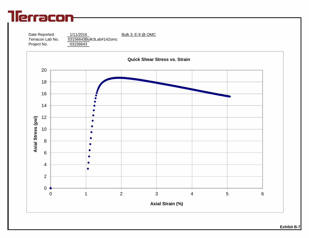
Date Reported: 1/11/2016Terracon Lab No. 03156643Bulk3Lab#142omcProject No. 03156643
Bulk 3: E-9 @ OMC
Exhibit B-7
0
2
4
6
8
10
12
14
16
18
20
0 1 2 3 4 5 6
Axi
alSt
ress
(psi
)
Axial Strain (%)
Quick Shear Stress vs. Strain

Resilient Modulus Testing - AASHTO T 307-99 English Units Report Date: 11-Jan-16Lab No.: 03156643Bulk3Lab#1042omc+2Project No.: 03156643
Soil Map Unit: Bulk 3: E-9 @ OMC+2%A-2-4(0) / SM 6.53 Test Date: December 22, 2015
6-36 3.94Compaction Method Static 7.87 Final Sample Height (in) 7.8Max. Dry Density (pcf) 107.3 12.17 Final Sample Wet Weight (lb) 6.52Opt. Moisture Content (%) 13.4 95.86 Final Moisture Content (%) 15.6
3.94 15.7 Accumulated Strain (%) 1.57117.6101.6 Percent Passing No. 10 99
Percent Passing No. 200 17.0Liquid Limit NPPlasticity Index NP
(S3) (Scyclic) (Pmax) (Pcyclic) (Pcontact) (Smax) (Scyclic) (Scontact) (H1) (H2) (Havg) (Єr) (Mr)psi psi lb lb lb psi psi psi in in in in/in psi6.00 2.00 23.5 20.3 3.2 1.93 1.67 0.260 0.0016 0.0015 0.0016 0.000199 8,3986.00 4.00 47.6 42.1 5.5 3.91 3.46 0.450 0.0031 0.0030 0.0030 0.000387 8,9296.01 6.00 71.8 63.2 8.6 5.90 5.19 0.704 0.0044 0.0043 0.0044 0.000556 9,3486.00 8.00 96.6 85.8 10.8 7.93 7.05 0.884 0.0060 0.0058 0.0059 0.000745 9,4656.00 10.00 121.2 108.2 13.1 9.96 8.88 1.074 0.0075 0.0071 0.0073 0.000927 9,5854.01 2.00 23.2 20.4 2.9 1.91 1.67 0.236 0.0019 0.0019 0.0019 0.000242 6,9144.01 4.00 47.6 42.4 5.1 3.91 3.49 0.421 0.0040 0.0039 0.0040 0.000505 6,9064.01 6.00 72.0 64.3 7.7 5.92 5.28 0.634 0.0059 0.0056 0.0057 0.000730 7,2344.01 8.00 96.5 86.1 10.4 7.92 7.07 0.850 0.0074 0.0071 0.0072 0.000919 7,6994.01 10.00 120.8 107.9 12.9 9.92 8.86 1.061 0.0090 0.0084 0.0087 0.001105 8,0232.00 2.00 23.0 20.4 2.6 1.89 1.68 0.210 0.0027 0.0026 0.0027 0.000339 4,9462.00 4.00 47.4 42.5 4.9 3.89 3.49 0.401 0.0054 0.0054 0.0054 0.000686 5,0842.00 6.00 71.7 64.3 7.4 5.89 5.28 0.606 0.0075 0.0073 0.0074 0.000936 5,6422.00 8.00 96.3 86.5 9.8 7.91 7.11 0.804 0.0096 0.0091 0.0094 0.001191 5,9662.00 10.00 119.0 107.0 12.0 9.77 8.79 0.987 0.0137 0.0128 0.0132 0.001680 5,231
Soil Symbol: Weight of Wet Soil (lb)Initial Sample Diameter (in)
Wet Density (pcf)Dry Density (pcf)
Inside Mold Diameter (in)
Depth (in.)Initial Sample Height (in)Initial Sample Area (in2)Sample Volume (in3)Compacted Moisture Content(%)
Exhibit B-7
ChamberConfiningPressure
ActualApplied Max.Axial Load
ActualAppliedCyclicLoad
Recov.Def. LVDT
#2Reading
Recov. Def.LVDT #1Reading
ActualAppliedContactStress
ActualAppliedCyclicStress
ActualApplied
Max. AxialStress Resilient Strain
ResilientModulus
NominalMaximum
AxialStress
AverageRecov.
Def. LVDT1 and 2
ActualAppliedContact
Load

Date Reported: 1/11/2016 Bulk 3: E-9 @ OMC+2%Terracon Lab No. 03156643Bulk3Lab#1042omc+2Project No. 03156643
S3 (psi) K1 K2 R2
Mr = K1 x Qk2 6 2449.6 0.419 0.914 2503.9 0.379 0.90
[Q = Scyclic + 3 (S3)] 2 3449.3 0.184 0.38All 1303.1 0.608 0.88
Exhibit B-7
1000
10000
1 10 100
Mr(p
si)
Bulk Stress, (psi)

Date Reported: 1/11/2016Terracon Lab No. 03156643Bulk3Lab#1042omc+2Project No. 03156643
Bulk 3: E-9 @ OMC+2%
Exhibit B-7
0
2
4
6
8
10
12
14
16
18
20
0 1 2 3 4 5 6
Axi
alSt
ress
(psi
)
Axial Strain (%)
Quick Shear Stress vs. Strain

Resilient Modulus Testing - AASHTO T 307-99 English Units Report Date: 11-Jan-16Lab No.: 03156643Bulk4Lab#1047omcProject No.: 03156643
Soil Map Unit: Bulk 4: E-35 @ OMCA-6(10) / CL 6.81 Test Date: December 22, 2015
6-36 3.94Compaction Method Static 7.87 Final Sample Height (in) 7.9Max. Dry Density (pcf) 112.8 12.17 Final Sample Wet Weight (lb) 6.81Opt. Moisture Content (%) 14.6 95.86 Final Moisture Content (%) 15.1
3.94 15.0 Accumulated Strain (%) 0.14122.8106.8 Percent Passing No. 10 100
Percent Passing No. 200 60.0Liquid Limit 39Plasticity Index 21
(S3) (Scyclic) (Pmax) (Pcyclic) (Pcontact) (Smax) (Scyclic) (Scontact) (H1) (H2) (Havg) (Єr) (Mr)psi psi lb lb lb psi psi psi in in in in/in psi6.00 2.00 23.3 20.2 3.2 1.92 1.66 0.261 0.0010 0.0009 0.0010 0.000122 13,5316.00 4.00 47.4 42.0 5.4 3.89 3.45 0.443 0.0022 0.0020 0.0021 0.000266 12,9576.00 6.00 71.7 63.6 8.1 5.89 5.23 0.666 0.0036 0.0034 0.0035 0.000446 11,7096.00 8.00 96.3 85.7 10.6 7.91 7.04 0.870 0.0054 0.0052 0.0053 0.000674 10,4306.00 10.00 121.1 108.1 13.0 9.94 8.88 1.069 0.0074 0.0072 0.0073 0.000925 9,5934.01 2.00 23.5 20.3 3.2 1.93 1.67 0.265 0.0011 0.0010 0.0011 0.000138 12,0604.00 4.00 48.0 42.5 5.5 3.94 3.49 0.448 0.0025 0.0023 0.0024 0.000309 11,2944.01 6.00 72.3 64.5 7.9 5.94 5.29 0.647 0.0041 0.0039 0.0040 0.000510 10,3904.01 8.00 96.8 86.5 10.3 7.95 7.11 0.845 0.0059 0.0057 0.0058 0.000735 9,6604.01 10.00 120.8 108.1 12.7 9.92 8.88 1.042 0.0078 0.0077 0.0077 0.000984 9,0232.00 2.00 23.4 20.6 2.8 1.92 1.70 0.229 0.0014 0.0013 0.0013 0.000171 9,9392.00 4.00 47.7 42.6 5.1 3.92 3.50 0.416 0.0029 0.0028 0.0029 0.000364 9,6162.00 6.00 72.1 64.6 7.5 5.92 5.31 0.618 0.0047 0.0046 0.0046 0.000589 9,0122.00 8.00 96.5 86.5 9.9 7.92 7.10 0.817 0.0066 0.0065 0.0066 0.000833 8,5302.00 10.00 120.7 108.2 12.5 9.91 8.89 1.029 0.0087 0.0085 0.0086 0.001098 8,093
Exhibit B-8
ChamberConfiningPressure
ActualApplied Max.Axial Load
ActualAppliedCyclicLoad
Recov.Def. LVDT
#2Reading
Recov. Def.LVDT #1Reading
ActualAppliedContactStress
ActualAppliedCyclicStress
ActualApplied
Max. AxialStress Resilient Strain
ResilientModulus
NominalMaximum
AxialStress
AverageRecov.
Def. LVDT1 and 2
ActualAppliedContact
Load
Soil Symbol: Weight of Wet Soil (lb)Initial Sample Diameter (in)
Wet Density (pcf)Dry Density (pcf)
Inside Mold Diameter (in)
Depth (in.)Initial Sample Height (in)Initial Sample Area (in2)Sample Volume (in3)Compacted Moisture Content(%)

Date Reported: 1/11/2016 Bulk 4: E-35 @ OMCTerracon Lab No. 03156643Bulk4Lab#1047omcProject No. 03156643
S3 (psi) K1 K2 R2
Mr = K1 x Scylick2 6 15709.6 -0.204 0.88
4 13507.5 -0.171 0.942 10858.9 -0.123 0.91All 13248.0 -0.168 0.46
Exhibit B-8
1000
10000
100000
0 1 10
Mr(p
si)
Scyclic (psi)

Date Reported: 1/11/2016Terracon Lab No. 03156643Bulk4Lab#1047omcProject No. 03156643
Bulk 4: E-35 @ OMC
Exhibit B-8
0
5
10
15
20
25
30
35
0 1 2 3 4 5 6
Axi
alSt
ress
(psi
)
Axial Strain (%)
Quick Shear Stress vs. Strain

Resilient Modulus Testing - AASHTO T 307-99 English Units Report Date: 11-Jan-16Lab No.: 03156643Bulk4Lab#1047omc+Project No.: 03156643
Soil Map Unit: Bulk 4: E-35 @ OMC+A-6(10) / CL 6.99 Test Date: December 22, 2015
6-36 3.94Compaction Method Static 7.87 Final Sample Height (in) 7.8Max. Dry Density (pcf) 112.8 12.17 Final Sample Wet Weight (lb) 6.99Opt. Moisture Content (%) 14.6 95.86 Final Moisture Content (%) 17.7
3.94 17.8 Accumulated Strain (%) 0.43125.9106.9 Percent Passing No. 10 100
Percent Passing No. 200 60.0Liquid Limit 39Plasticity Index 21
(S3) (Scyclic) (Pmax) (Pcyclic) (Pcontact) (Smax) (Scyclic) (Scontact) (H1) (H2) (Havg) (Єr) (Mr)psi psi lb lb lb psi psi psi in in in in/in psi6.00 2.00 23.6 20.5 3.1 1.94 1.68 0.257 0.0014 0.0013 0.0013 0.000169 9,9776.00 4.00 47.9 42.5 5.4 3.93 3.49 0.446 0.0031 0.0029 0.0030 0.000386 9,0426.01 6.00 72.4 64.1 8.3 5.94 5.26 0.682 0.0056 0.0053 0.0054 0.000689 7,6416.00 8.00 96.8 85.8 11.0 7.95 7.05 0.902 0.0088 0.0082 0.0085 0.001078 6,5426.00 10.00 121.3 107.7 13.6 9.96 8.84 1.117 0.0119 0.0110 0.0114 0.001452 6,0894.00 2.00 23.6 20.4 3.2 1.94 1.68 0.262 0.0016 0.0015 0.0015 0.000196 8,5404.01 4.00 47.8 42.2 5.6 3.93 3.47 0.459 0.0038 0.0035 0.0037 0.000467 7,4314.01 6.00 72.3 64.1 8.1 5.94 5.27 0.668 0.0066 0.0062 0.0064 0.000814 6,4724.01 8.00 96.7 86.1 10.6 7.94 7.07 0.869 0.0099 0.0092 0.0095 0.001209 5,8524.01 10.00 121.1 107.9 13.1 9.94 8.87 1.077 0.0131 0.0122 0.0127 0.001609 5,5092.00 2.00 23.4 20.5 2.9 1.92 1.68 0.239 0.0019 0.0017 0.0018 0.000232 7,2352.00 4.00 47.7 42.4 5.3 3.92 3.48 0.436 0.0046 0.0042 0.0044 0.000562 6,1962.00 6.00 72.1 64.3 7.7 5.92 5.28 0.636 0.0080 0.0075 0.0078 0.000986 5,3592.00 8.00 96.5 86.2 10.3 7.93 7.08 0.847 0.0116 0.0108 0.0112 0.001424 4,9722.00 10.00 120.8 108.1 12.7 9.92 8.88 1.042 0.0153 0.0143 0.0148 0.001876 4,732
Soil Symbol: Weight of Wet Soil (lb)Initial Sample Diameter (in)
Wet Density (pcf)Dry Density (pcf)
Inside Mold Diameter (in)
Depth (in.)Initial Sample Height (in)Initial Sample Area (in2)Sample Volume (in3)Compacted Moisture Content(%)
Exhibit B-8
ChamberConfiningPressure
ActualApplied Max.Axial Load
ActualAppliedCyclicLoad
Recov.Def. LVDT
#2Reading
Recov. Def.LVDT #1Reading
ActualAppliedContactStress
ActualAppliedCyclicStress
ActualApplied
Max. AxialStress Resilient Strain
ResilientModulus
NominalMaximum
AxialStress
AverageRecov.
Def. LVDT1 and 2
ActualAppliedContact
Load

Date Reported: 1/11/2016 Bulk 4: E-35 @ OMC+Terracon Lab No. 03156643Bulk4Lab#1047omc+Project No. 03156643
S3 (psi) K1 K2 R2
Mr = K1 x Scylick2 6 12314.8 -0.309 0.93
4 10023.0 -0.269 0.982 8378.6 -0.263 0.99All 10115.2 -0.280 0.60
Exhibit B-8
1000
10000
0 1 10
Mr(p
si)
Scyclic (psi)

Date Reported: 1/11/2016Terracon Lab No. 03156643Bulk4Lab#1047omc+Project No. 03156643
Bulk 4: E-35 @ OMC+
Exhibit B-8
0
5
10
15
20
25
0 1 2 3 4 5 6
Axi
alSt
ress
(psi
)
Axial Strain (%)
Quick Shear Stress vs. Strain

APPENDIX CSUPPORTING DOCUMENTS

01 - 1011 - 30
> 30
RELATIVE PROPORTIONS OF FINES
Descriptive Term(s)of other constituents
Percent ofDry Weight
Hand Penetrometer
Torvane
Standard PenetrationTest (blows per foot)
Photo-Ionization Detector
Organic Vapor Analyzer
Texas Cone Penetrometer
TraceWithModifier
Water Level Aftera Specified Period of Time
GRAIN SIZE TERMINOLOGYRELATIVE PROPORTIONS OF SAND AND GRAVEL
TraceWithModifier
Standard Penetration orN-Value
Blows/Ft.
Descriptive Term(Consistency)
Loose
Very Stiff
Standard Penetration orN-Value
Blows/Ft.
Ring SamplerBlows/Ft.
Ring SamplerBlows/Ft.
Medium Dense
Dense
Very Dense
0 - 1 < 3
4 - 9 2 - 4 3 - 4
Medium-Stiff 5 - 9
30 - 50
WA
TE
R L
EV
EL
Auger
Shelby Tube
Grab Sample
FIE
LD
TE
ST
S
DESCRIPTION OF SYMBOLS AND ABBREVIATIONS
Descriptive Term(Density)
Non-plasticLowMediumHigh
BouldersCobblesGravelSandSilt or Clay
10 - 18
> 50 15 - 30 19 - 42
> 30 > 42
_
Water levels indicated on the soil boringlogs are the levels measured in theborehole at the times indicated.Groundwater level variations will occurover time. In low permeability soils,accurate determination of groundwaterlevels is not possible with short termwater level observations.
CONSISTENCY OF FINE-GRAINED SOILS
(50% or more passing the No. 200 sieve.)Consistency determined by laboratory shear strength testing, field
visual-manual procedures or standard penetration resistance
DESCRIPTIVE SOIL CLASSIFICATION
> 8,000
Unless otherwise noted, Latitude and Longitude are approximately determined using a hand-held GPS device. The accuracyof such devices is variable. Surface elevation data annotated with +/- indicates that no actual topographical survey wasconducted to confirm the surface elevation. Instead, the surface elevation was approximately determined from topographicmaps of the area.
Soil classification is based on the Unified Soil Classification System. Coarse Grained Soils have more than 50% of their dryweight retained on a #200 sieve; their principal descriptors are: boulders, cobbles, gravel or sand. Fine Grained Soils haveless than 50% of their dry weight retained on a #200 sieve; they are principally described as clays if they are plastic, andsilts if they are slightly plastic or non-plastic. Major constituents may be added as modifiers and minor constituents may beadded according to the relative proportions based on grain size. In addition to gradation, coarse-grained soils are definedon the basis of their in-place relative density and fine-grained soils on the basis of their consistency.
Plasticity Index
8 - 15
Split Spoon
Rock Core
PLASTICITY DESCRIPTION
Term
< 1515 - 29> 30
Descriptive Term(s)of other constituents
Water InitiallyEncountered
Water Level After aSpecified Period of Time
Major Componentof Sample
Percent ofDry Weight
(More than 50% retained on No. 200 sieve.)Density determined by Standard Penetration Resistance
Includes gravels, sands and silts.
Hard
Very Loose 0 - 3 0 - 6 Very Soft
7 - 18 Soft
10 - 29 19 - 58
59 - 98 Stiff
less than 500
500 to 1,000
1,000 to 2,000
2,000 to 4,000
4,000 to 8,000> 99
LOCATION AND ELEVATION NOTES
SA
MP
LIN
G
< 55 - 12> 12
No Recovery
RELATIVE DENSITY OF COARSE-GRAINED SOILS
Particle Size
Over 12 in. (300 mm)12 in. to 3 in. (300mm to 75mm)3 in. to #4 sieve (75mm to 4.75 mm)#4 to #200 sieve (4.75mm to 0.075mmPassing #200 sieve (0.075mm)
ST
RE
NG
TH
TE
RM
S Unconfined CompressiveStrength, Qu, psf
4 - 8
GENERAL NOTES
Texas Cone
(HP)
(T)
(b/f)
(PID)
(OVA)
(TCP)
Pressure Meter
Exhibit C-1

UNIFIED SOIL CLASSIFICATION SYSTEM
Criteria for Assigning Group Symbols and Group Names Using Laboratory Tests A Soil Classification
Group Symbol
Group Name B
Coarse Grained Soils: More than 50% retained on No. 200 sieve
Gravels: More than 50% of coarse fraction retained on No. 4 sieve
Clean Gravels: Less than 5% fines C
Cu 4 and 1 Cc 3 E GW Well-graded gravel F
Cu 4 and/or 1 Cc 3 E GP Poorly graded gravel F
Gravels with Fines: More than 12% fines C
Fines classify as ML or MH GM Silty gravel F,G,H
Fines classify as CL or CH GC Clayey gravel F,G,H
Sands: 50% or more of coarse fraction passes No. 4 sieve
Clean Sands: Less than 5% fines D
Cu 6 and 1 Cc 3 E SW Well-graded sand I
Cu 6 and/or 1 Cc 3 E SP Poorly graded sand I
Sands with Fines: More than 12% fines D
Fines classify as ML or MH SM Silty sand G,H,I
Fines classify as CL or CH SC Clayey sand G,H,I
Fine-Grained Soils: 50% or more passes the No. 200 sieve
Silts and Clays: Liquid limit less than 50
Inorganic: PI 7 and plots on or above “A” line J CL Lean clay K,L,M
PI 4 or plots below “A” line J ML Silt K,L,M
Organic: Liquid limit - oven dried
0.75 OL Organic clay K,L,M,N
Liquid limit - not dried Organic silt K,L,M,O
Silts and Clays: Liquid limit 50 or more
Inorganic: PI plots on or above “A” line CH Fat clay K,L,M
PI plots below “A” line MH Elastic Silt K,L,M
Organic: Liquid limit - oven dried
0.75 OH Organic clay K,L,M,P
Liquid limit - not dried Organic silt K,L,M,Q
Highly organic soils: Primarily organic matter, dark in color, and organic odor PT Peat
A Based on the material passing the 3-inch (75-mm) sieve B If field sample contained cobbles or boulders, or both, add “with cobbles
or boulders, or both” to group name. C Gravels with 5 to 12% fines require dual symbols: GW-GM well-graded
gravel with silt, GW-GC well-graded gravel with clay, GP-GM poorly graded gravel with silt, GP-GC poorly graded gravel with clay.
D Sands with 5 to 12% fines require dual symbols: SW-SM well-graded sand with silt, SW-SC well-graded sand with clay, SP-SM poorly graded sand with silt, SP-SC poorly graded sand with clay
E Cu = D60/D10 Cc =
6010
2
30
DxD
)(D
F If soil contains 15% sand, add “with sand” to group name. G If fines classify as CL-ML, use dual symbol GC-GM, or SC-SM.
H If fines are organic, add “with organic fines” to group name. I If soil contains 15% gravel, add “with gravel” to group name. J If Atterberg limits plot in shaded area, soil is a CL-ML, silty clay. K If soil contains 15 to 29% plus No. 200, add “with sand” or “with gravel,”
whichever is predominant. L If soil contains 30% plus No. 200 predominantly sand, add “sandy” to
group name. M If soil contains 30% plus No. 200, predominantly gravel, add
“gravelly” to group name. N PI 4 and plots on or above “A” line. O PI 4 or plots below “A” line. P PI plots on or above “A” line. Q PI plots below “A” line.
Exhibit C-2