Geospatial Technologies for the Agricultural Sciences
27
Geospatial Technologies for the Geospatial Technologies for the Agricultural Sciences Agricultural Sciences Maggi Maggi Kelly Kelly Assoc. Cooperative Extension Specialist Assoc. Cooperative Extension Specialist Department of Environmental Science, Policy & Management Department of Environmental Science, Policy & Management Director, GIIF Director, GIIF UC Berkeley UC Berkeley Karin Tuxen Karin Tuxen GIIF GIIF College of Natural Resources College of Natural Resources UC Berkeley UC Berkeley Geospatial Imaging & Informatics Facility Geospatial Imaging & Informatics Facility College of Natural Resources @ UC Berkeley College of Natural Resources @ UC Berkeley
Transcript of Geospatial Technologies for the Agricultural Sciences

Geospatial Technologies for theGeospatial Technologies for theAgricultural SciencesAgricultural Sciences
Maggi Maggi KellyKellyAssoc. Cooperative Extension SpecialistAssoc. Cooperative Extension SpecialistDepartment of Environmental Science, Policy & ManagementDepartment of Environmental Science, Policy & Management
Director, GIIFDirector, GIIFUC BerkeleyUC Berkeley
Karin TuxenKarin TuxenGIIFGIIF
College of Natural ResourcesCollege of Natural Resources
UC BerkeleyUC Berkeley
Geospatial Imaging & Informatics FacilityGeospatial Imaging & Informatics FacilityCollege of Natural Resources @ UC BerkeleyCollege of Natural Resources @ UC Berkeley

OutlineOutline
••
What are the technologies?What are the technologies?
••
GPS detailsGPS details––
Improving GPS accuracy/reducing errorImproving GPS accuracy/reducing error
––
GPS unitsGPS units
••
Integration with GISIntegration with GIS––
GIS software packages, including freewareGIS software packages, including freeware
––
Geospatial data & imageryGeospatial data & imagery
••
Applications for agricultural field researchApplications for agricultural field research

What is GPS?What is GPS? GGloballobal
PPositioningositioning
SSystemsystems
••
24 satellites make up civilian GPS24 satellites make up civilian GPS
••
66--7 satellites are visible from any spot on Earth7 satellites are visible from any spot on Earth
••
4 or more GPS 4 or more GPS satellites used to satellites used to compute X, Y, and Z.compute X, Y, and Z.

How GPS WorksHow GPS Works••
Need 4 or more satellites for accurate location!Need 4 or more satellites for accurate location!
Image credit: NOAAImage credit: NOAA

GPS AccuracyGPS Accuracy
Accuracy primarily depends on: Accuracy primarily depends on: 1.1.
Number of satellites used to calculate Number of satellites used to calculate positionposition
2.2.
Strength of the signal of those satellitesStrength of the signal of those satellites
3.3.
Satellite positionSatellite position••
Positional Dilution of Precision (PDOP) Positional Dilution of Precision (PDOP)
4.4.
Differential Correction ProceduresDifferential Correction Procedures••
WAAS (can improve to 2WAAS (can improve to 2--5m)5m)
••
DGPS (can improve to 0.1DGPS (can improve to 0.1--1m)1m)
(Your GPS unit must be WAAS(Your GPS unit must be WAAS--
or or DGPSDGPS--compatible!)compatible!)
GOOD PDOPGOOD PDOP
GOOD PDOP GOOD PDOP –– BAD VISIBILITYBAD VISIBILITY
POOR PDOPPOOR PDOP
Image credit: P.H. Dana, GarminImage credit: P.H. Dana, Garmin
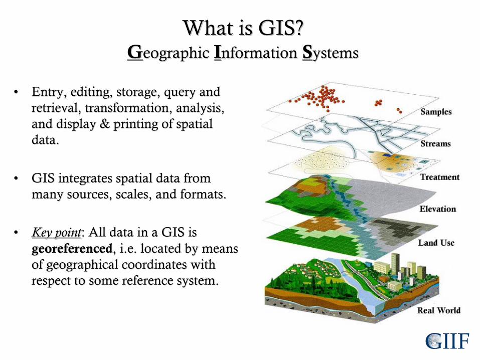
What is GIS?What is GIS? GGeographiceographic
IInformationnformation
SSystemsystems
••
Entry, editing, storage, query and Entry, editing, storage, query and retrieval, transformation, analysis, retrieval, transformation, analysis, and display & printing of spatial and display & printing of spatial data.data.
••
GIS integrates spatial data from GIS integrates spatial data from many sources, scales, and formats.many sources, scales, and formats.
••
Key pointKey point: All data in a GIS is : All data in a GIS is georeferencedgeoreferenced, i.e. located by means , i.e. located by means of geographical coordinates with of geographical coordinates with respect to some reference system.respect to some reference system.

What is remote sensing?What is remote sensing?
••
The capture of information about the EarthThe capture of information about the Earth’’s surface from a s surface from a distance, usually an airplane or satellite.distance, usually an airplane or satellite.
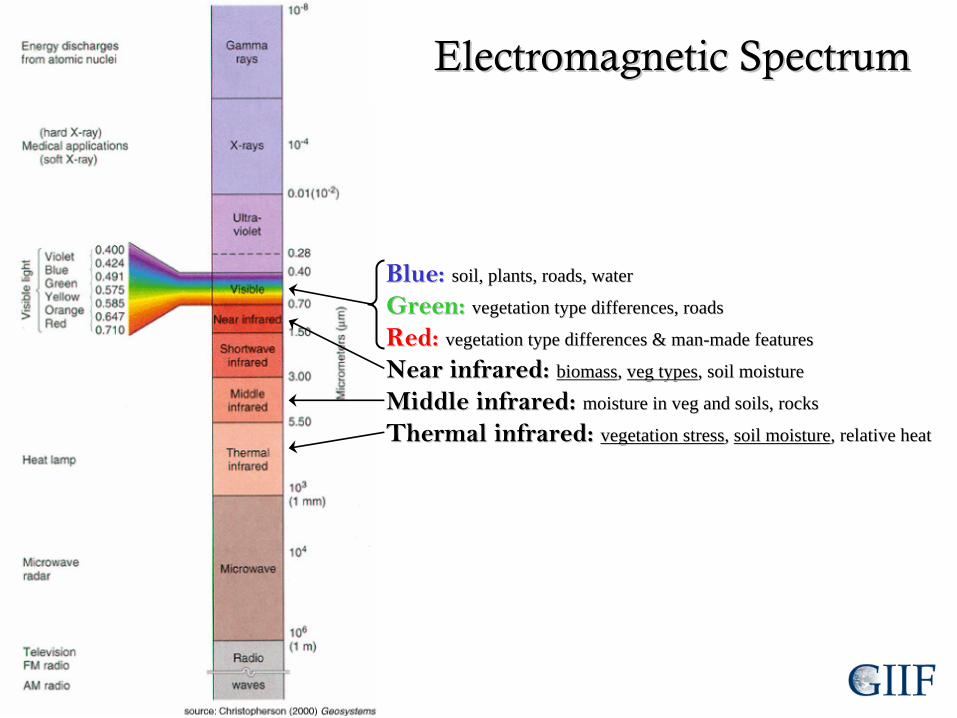
Blue:Blue:
soil, plants, roads, watersoil, plants, roads, water
Green: Green: vegetation type differences, roadsvegetation type differences, roads
Red: Red: vegetation type differences & manvegetation type differences & man--made featuresmade features
Near infrared: Near infrared: biomassbiomass, , vegveg typestypes, soil moisture, soil moisture
Middle infrared: Middle infrared: moisture in moisture in vegveg and soils, rocksand soils, rocks
Thermal infrared: Thermal infrared: vegetation stressvegetation stress, , soil moisturesoil moisture, relative heat, relative heat
Electromagnetic SpectrumElectromagnetic Spectrum

Applications for Agricultural Field ResearchApplications for Agricultural Field Research
••
Precision agriculture includes the use of GPS, GIS, and remote sPrecision agriculture includes the use of GPS, GIS, and remote sensing ensing to manage practices in variable field conditions.to manage practices in variable field conditions.
••
Map, monitor, and manage:Map, monitor, and manage:––
Crop ProductionCrop Production••
Crop PatternCrop Pattern
••
Crop Yield (using NIR bands)Crop Yield (using NIR bands)
––
IrrigationIrrigation
––
Moisture, Water stressMoisture, Water stress
(using Thermal bands)(using Thermal bands)
––
Soil ManagementSoil Management••
Moisture (using Thermal bands)Moisture (using Thermal bands)
••
NutrientsNutrients
––
Pests detection and monitoringPests detection and monitoring••
Spray applicationsSpray applications
Image credits: http://www.gisrs.com/Agric.html

GPS Options for Field ResearchGPS Options for Field Research
••
Garmin w/ field notesGarmin w/ field notes––
Handheld GPSHandheld GPS
––
Field notebookField notebook
––
PROSPROS••
Simple, lightSimple, light--weight, and weight, and inexpensiveinexpensive
––
CONSCONS••
Only gives GPS coordinatesOnly gives GPS coordinates
••
Restricted to lower accuracy Restricted to lower accuracy (2(2--15 m error)15 m error)
••
Field PDA systemField PDA system––
PDAPDA
––
GPSGPS
––
SoftwareSoftware
––
PROSPROS••
Collects data electronicallyCollects data electronically
••
Uses custom programs and Uses custom programs and formsforms
••
Overlay GPS points on Overlay GPS points on imagery in the fieldimagery in the field
••
Improved accuracy Improved accuracy (up to 10 cm)(up to 10 cm)
––
CONSCONS••
ExpensiveExpensive
••
Sometimes NOT userSometimes NOT user--friendlyfriendly
••
Less lightLess light--weightweight

Handheld GPS UnitsHandheld GPS Units
••
Accuracy is usually 5Accuracy is usually 5--15m; 15m; can be as much as 50m can be as much as 50m due under heavy canopy, due under heavy canopy, PDOP, etc.PDOP, etc.
••
Cannot set PDOP Cannot set PDOP thresholdthreshold
••
Some have WAAS Some have WAAS differential correction to differential correction to improve accuracy to 2improve accuracy to 2--5m.5m.

Guide to the Handheld Garmin modelsGuide to the Handheld Garmin models
••
C C ––
Color displayColor display
••
S S ––
Electronic compass and barometric altimeterElectronic compass and barometric altimeter
••
X X ––
Expandable memory, new Expandable memory, new SiRFSiRF
chipchip
GarminGarminGPSmapGPSmap
60 60 CSxCSxGarminGarmin
eTrexeTrex
Vista Vista CxCxGarminGarmin
GPSmapGPSmap
76 C76 C

Field PDA+GPS:Field PDA+GPS:
What You NeedWhat You Need
••
PDA:PDA:
••
GPS (if needed):GPS (if needed):
••
SoftwareSoftware GPS Pathfinder OfficeGPS Pathfinder Office

GPS for Agricultural Field ResearchGPS for Agricultural Field Research
••
What are your accuracy needs?What are your accuracy needs?––
22--15 m 15 m ……handheld units are okayhandheld units are okay
––
<2 m <2 m ……mappingmapping--grade units are grade units are neededneeded
••
GPS good for mapping points, lines, GPS good for mapping points, lines, and polygons of relatively small areasand polygons of relatively small areas––
Very large areas should be Very large areas should be mapped/digitized using imagery in a mapped/digitized using imagery in a GIS.GIS.
••
How much data will you collect?How much data will you collect?––
Points, lines, AND polygons?Points, lines, AND polygons?
––
Extensive field note taking?Extensive field note taking?

GPS StandardizationGPS Standardization
••
Position FormatPosition Format––
How 3How 3--D earth is mapped on aD earth is mapped on a
22--D surfaceD surface
––
Same thing as Same thing as ““projectionprojection””
••
Map DatumMap Datum––
Mathematical model that fits Mathematical model that fits the earth to an ellipsoidthe earth to an ellipsoid

GPS StandardizationGPS Standardization
••
Latitude/longitude is OK, butLatitude/longitude is OK, but……––
Lat/long is not consistent across Earth.Lat/long is not consistent across Earth.––
Misinterpretation of the three different formats Misinterpretation of the three different formats (degrees(degrees--minutesminutes--seconds, degreesseconds, degrees--decimal decimal minutes, and decimal degrees) can cause error.minutes, and decimal degrees) can cause error.
––
Rounding lat/long numbers can cause error.Rounding lat/long numbers can cause error.
••
Use UTMUse UTM––
Numbers represent meters, so each integer is a meter.Numbers represent meters, so each integer is a meter.
––
Split into zones so there are never negative numbersSplit into zones so there are never negative numbers
••
Most important thing is to Most important thing is to be consistentbe consistent
and and documentdocument
what what
you do!you do!

Geospatial Data ExamplesGeospatial Data Examples
RoadsRoads
CountiesCounties
Soil typeSoil type
Census dataCensus data
GPS dataGPS data
Habitat boundariesHabitat boundaries
RiversRivers

Geospatial Data ExamplesGeospatial Data Examples
Satellite imagerySatellite imageryElevationElevation
Aerial photographyAerial photography
TemperatureTemperature
Digital USGSDigital USGS topotopo mapmap
PrecipitationPrecipitation
Landcover/landuseLandcover/landuse

Free Geospatial Data for Calif.Free Geospatial Data for Calif.
••
California Spatial Information Library:California Spatial Information Library:
http://gis.ca.gov/data.eplhttp://gis.ca.gov/data.epl
••
Cal GAP Project:Cal GAP Project:
http://www.biogeog.ucsb.edu/
projects/gap/gap_data2.html
•
CDF FRAP:http://frap.cdf.ca.gov/infocenter.htmlhttp://frap.cdf.ca.gov/infocenter.html
Includes geospatial data, such as political, cultural, and physical data.
Also includes some imagery!

ImageryImagery
••
National Agriculture Imagery Program (NAIP)National Agriculture Imagery Program (NAIP)
––
free!free!
http://new.casil.ucdavis.edu/casil/remote_sensing/naip_2005/http://new.casil.ucdavis.edu/casil/remote_sensing/naip_2005/
Annual trueAnnual true--color aerial photography for the entire state of CA (1m)color aerial photography for the entire state of CA (1m)
NearNear--infrared flown but not yet available.infrared flown but not yet available.
••
USGS:USGS:
http://http://seamless.usgs.govseamless.usgs.gov//
--
free!free!
Aerial photography of urban areas flown in 2002 (60cm) & in Aerial photography of urban areas flown in 2002 (60cm) & in 2004 (1m) 2004 (1m) ––
not of entire state though!not of entire state though!
••
NextMapNextMap
California: California: http://http://www.intermap.com/corporate/california.cfmwww.intermap.com/corporate/california.cfm
Elevation and imagery of the entire state (1m)Elevation and imagery of the entire state (1m)
••
Satellite imagery? Satellite imagery? ……can be very expensive.can be very expensive.
••
Fly your own aerial photography? Fly your own aerial photography? ……useful but can be useful but can be expensive.expensive.
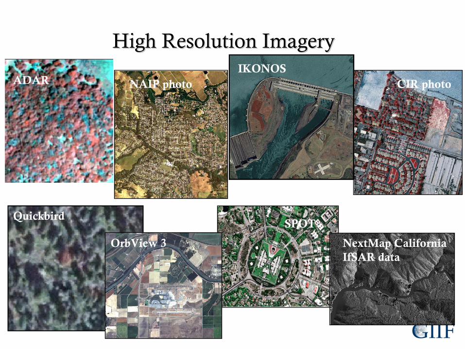
High Resolution ImageryHigh Resolution Imagery
NAIP photoADARIKONOS
CIR photo
OrbView
3
QuickbirdSPOT
NextMap
CaliforniaIfSAR
data

GIS Software:GIS Software: VisualizingVisualizing
your geospatial datayour geospatial data
Google Earth PlusGoogle Earth Plus($20/yr)($20/yr)
Google Earth Pro Google Earth Pro ($400/yr)($400/yr)
Pros:Pros:••
Easily integrate your Easily integrate your GPS dataGPS data
••
Add geospatial dataAdd geospatial data••
Use GoogleUse Google’’s huge s huge database of imagerydatabase of imagery
Cons:Cons:••
Imagery might not be Imagery might not be good for your sitegood for your site
••
No spatial analysesNo spatial analyses

GIS Software:GIS Software: Make mapsMake maps
Quantum GIS (QGIS)Quantum GIS (QGIS)(free)(free)
Pros:Pros:••
Add geospatial dataAdd geospatial data••
Transfer your GPS Transfer your GPS points, after some setuppoints, after some setup
••
Runs on PC and MacRuns on PC and Mac
Cons:Cons:••
Sometimes finickySometimes finicky••
No spatial analysesNo spatial analyses••
Projection & datum Projection & datum must be the samemust be the same

GIS Software:GIS Software: AnalyzingAnalyzing
your geospatial datayour geospatial data
ArcGISArcGIS
Pros:Pros:••
Extremely powerful Extremely powerful spatial analysesspatial analyses
••
The sky is the limit!The sky is the limit!••
Projection onProjection on--thethe--flyfly
Cons:Cons:••
Steep learning curve for Steep learning curve for performing analysesperforming analyses
––
What to do?What to do?––
Where to find the tool?Where to find the tool?––
How to prepare the data?)How to prepare the data?)

Spatial Analysis ExampleSpatial Analysis Example
You have GPS point samplesYou have GPS point samples––
Water levelWater level
––
NitrateNitrate
You can:You can:
••
Download NAIP imagery Download NAIP imagery of your site,of your site,
••
Plot your GPS points Plot your GPS points (with water level and (with water level and nitrate as nitrate as attributesattributes),),
••
Interpolate contours of Interpolate contours of water level,water level,
••
Interpolate surface of Interpolate surface of nitrate concentration, andnitrate concentration, and
••
Make a map for Make a map for distribution!distribution!

GIIF Workshops for UCCEGIIF Workshops for UCCE
••
Introduction to GPS & GISIntroduction to GPS & GIS––
Wednesday, May 23Wednesday, May 23––
Wednesday, June 13Wednesday, June 13
•• Intermediate/Advanced GISIntermediate/Advanced GIS––
Thursday, July 5Thursday, July 5thth
––
Tuesday, July 24Tuesday, July 24thth
––
Tuesday, August 14Tuesday, August 14thth
––
Wednesday, September 5thWednesday, September 5th
•• Email Karin (Email Karin ([email protected]@nature.berkeley.edu) to register!) to register!
•• Visit Visit http://GIIF.cnr.berkeley.edu/RREA/http://GIIF.cnr.berkeley.edu/RREA/ for more info!for more info!
Funded by Renewable Resources ExtensionFunded by Renewable Resources Extension
Act (RREA)Act (RREA)
Tentative dates:
Tentative dates:
Check website!
Check website!

Handouts for Further ReferenceHandouts for Further Reference
http://http://GIIF.cnr.berkeley.eduGIIF.cnr.berkeley.edu