Geospatial Analysis of Forest Resources Availability for ... · Geospatial Analysis of Forest...
18
International Federation of Surveyors Article of the Month – February 2016 Him Lal SHRESTHA, Nawaraj CHAPAGAIN, Krishna Ram DHITAL and Sujan ADHIKARI (Nepal) Geospatial Analysis of Forest Resources Availability for the Reconstruction after Earthquake 2015 1/18 Geospatial Analysis of Forest Resources Availability for the Reconstruction after Earthquake 2015 Him Lal SHRESTHA, Nawaraj CHAPAGAIN, Krishna Ram DHITAL and Sujan ADHIKARI (Nepal) Keywords: Vicinity, Geographic Information System (GIS), Forest cover, timber extraction, spatial analysis ABSTRACT Government of Nepal had introduced community forestry program since 3 and half decades and achieved to hand over the patches of forests to more than 18000 forest user groups. Almost, the forest in each VDCs are hand over as community forests. The major activities implied in the CF are protection and conservation of the forest to ensure the greenery and the stock of the forest. The rest of the forest at community access is the national forest governed by governmental authorities such as Department of forest. The forest stocks are overwhelmingly high and there is scope of getting forest products for the community basic requirements. The recent devastating earthquake hit in Nepal put the pressure on land by degrading the lands as well as damaging the local infrastructure including private buildings, small houses, animal sheds. This has increased the local demand of forest resources to reconstruct the buildings. The current discussion are being increased to get permission to cut the forest of Chure Environment Conservation Area however that option is not feasible in terms of product delivery as well as environmental perspective. Thus, the aim of this study is to assess the resources available in the forests in locality taking the geospatial approach as the method of analysis. The study basically explored the resource available at local level which has spatial distributions differently at different geographic areas in Gorkha district where the epicenter lied. It will also see the cost and environmental significance of the resource delivery based on the transportation and other cost involved.Study tried to link the devastation due to earthquake, demand generated
Transcript of Geospatial Analysis of Forest Resources Availability for ... · Geospatial Analysis of Forest...
International Federation of Surveyors
Article of the Month – February 2016
Him Lal SHRESTHA, Nawaraj CHAPAGAIN, Krishna Ram DHITAL and Sujan ADHIKARI (Nepal)
Geospatial Analysis of Forest Resources Availability for the Reconstruction after Earthquake 2015
1/18
Geospatial Analysis of Forest Resources Availability for the Reconstruction
after Earthquake 2015
Him Lal SHRESTHA, Nawaraj CHAPAGAIN, Krishna Ram DHITAL and Sujan ADHIKARI
(Nepal)
Keywords: Vicinity, Geographic Information System (GIS), Forest cover, timber extraction,
spatial analysis
ABSTRACT
Government of Nepal had introduced community forestry program since 3 and half decades and
achieved to hand over the patches of forests to more than 18000 forest user groups. Almost, the
forest in each VDCs are hand over as community forests. The major activities implied in the CF
are protection and conservation of the forest to ensure the greenery and the stock of the forest.
The rest of the forest at community access is the national forest governed by governmental
authorities such as Department of forest. The forest stocks are overwhelmingly high and there is
scope of getting forest products for the community basic requirements. The recent devastating
earthquake hit in Nepal put the pressure on land by degrading the lands as well as damaging the
local infrastructure including private buildings, small houses, animal sheds. This has increased
the local demand of forest resources to reconstruct the buildings. The current discussion are
being increased to get permission to cut the forest of Chure Environment Conservation Area
however that option is not feasible in terms of product delivery as well as environmental
perspective. Thus, the aim of this study is to assess the resources available in the forests in
locality taking the geospatial approach as the method of analysis.
The study basically explored the resource available at local level which has spatial distributions
differently at different geographic areas in Gorkha district where the epicenter lied. It will also
see the cost and environmental significance of the resource delivery based on the transportation
and other cost involved.Study tried to link the devastation due to earthquake, demand generated
International Federation of Surveyors
Article of the Month – February 2016
Him Lal SHRESTHA, Nawaraj CHAPAGAIN, Krishna Ram DHITAL and Sujan ADHIKARI (Nepal)
Geospatial Analysis of Forest Resources Availability for the Reconstruction after Earthquake 2015
2/18
on forest resources and the resource availability in the locality. The geospatial approach has been
adopted to see the potential delivery of the resources in the district. The analysis included the
data available at different aspects such as forest coverage, distribution of the community forestry
intervention in local administrative unit, prescription of district level timber extraction in CFs
and the transportation opportunity in the district and vicinity villages.
The study concludes with the recommendation to the resource managers and policy makers not
to make the earthquake as a granted to cut the forest trees somewhere from the distant forest
stand. The local forest in the vicinity can supply sufficient timber.
BACKGROUND
The federal democratic republic of Nepal is located in between Tibetan (Chinese) and Indian
plates and lies in a seismically active region. According to world record Nepal is 11th
most
earthquake-prone country. Historical data shows that first earthquake was recorded in 1255 AD
in which King as well as one third population of Kathmandu valley was killed due to the tremor
of earthquake. Similarly, Nepal has faced major shock in 1934 with 8.4magnitudes. Earthquakes
have been causing several casualties damage in 1980, 1988 and 2011 AD (GoN, 2015).
The recent tremor was felt on 25th
April, 2015 firstly with the 7.6 magnitude and followed some
major aftershocks on more than 6.0 magnitude and more than 400 aftershocks of 4.0 magnitudes
in total and 29 aftershocks in Gorkha. As the main epicenter of this episode of the earthquake is
Barpak village of Gorkha district,it is later known as the “Gorkha Earthquake”. The hypocenter
of this earthquake was reported at the depth of approximately 8.2km (5.1 mile) from ground
surface. This shock cause more than 8856 human casualties loss from all over the country with
fully damaging 2673number of government buildings and 602257 numbers of private houses.
Similarly partial damage by this shock was in the number of government buildings and private
houses was 3,757 and 285,099 respectively (GoN, 2015).
The occurrence of such earthquakes in Nepal caused great destruction in human life as well as in
physical structures. This main shock is still followed by 400 numbers of aftershocks with local
greater or equal to 4 magnitude until 15th
October 2015 (Nepal seismology center) with the

International Federation of Surveyors
Article of the Month – February 2016
Him Lal SHRESTHA, Nawaraj CHAPAGAIN, Krishna Ram DHITAL and Sujan ADHIKARI (Nepal)
Geospatial Analysis of Forest Resources Availability for the Reconstruction after Earthquake 2015
3/18
moving epicenters in neighboring districts Nuwakot, Rasuwa, Dhading, Sindhupalchowk,
Dolakha. Thus, heavy destruction of human and physical infrastructure was on those districts.
Two villages of Gorkha, Barpark and Laprak have been totally flattened out by devastating
earthquake in April. While, people residing in Barpak and some other VDCs have initiated the
reconstruction of their temporary houses and farm house by reusing available residue of timber,
stone plates and zinc plates and other materials provided by Government and Non-government
organizations as a relief materials. But many of houses from Laprak and other remote VDCs are
still hopeful from government and non-governmental sectors for further help. On discussing
reconstruction of physical structures there are different modalities to resume in its original state.
One of them approved methodology by peoples society is by using community forest timber and
reusing residue of initial state.
Nepal has been practicing forest areas for special task operation at certain national emergency
time. At the time of armed conflict period, which was started from 1996 to 2006 AD in Nepal
both rebel and army group had used forest area for their specific purposes. Both of them ban for
local FUG on entering and harvesting forest products and used for this for training operations,
hiding purpose and barrack establishment. After peace process establishment in 2006; 31
thousands of People’s Liberation Army (PLA) of Communist Party Nepal (Maoist) was
reestablished by building cantonment at different 7 areas, which was the land of national forest
areas. Considering this approach and special law enforced in Forest Act 1993, Chapter 2- rule no
16 advocates on loose rule for government forest officers to collect and take out timber from the
forest area at any time for its sale and distribution to victims of natural calamities.
According to Government of Nepal, Department of Forest decided that total 50 cft. timber will
allocated for completely damaged private buildings and 20 cft. timber will allocated for partial
damage of private buildings. Again in case of intuitional buildings 100 cft. will allocated for
complete and 40 cft timber will allocated for partial damage. This analysis shows that there will
total 7805560 cubic foot of timber is essential for reconstructing total damages of physical
structures, which can also be calculated by following mathematic relation.
International Federation of Surveyors
Article of the Month – February 2016
Him Lal SHRESTHA, Nawaraj CHAPAGAIN, Krishna Ram DHITAL and Sujan ADHIKARI (Nepal)
Geospatial Analysis of Forest Resources Availability for the Reconstruction after Earthquake 2015
4/18
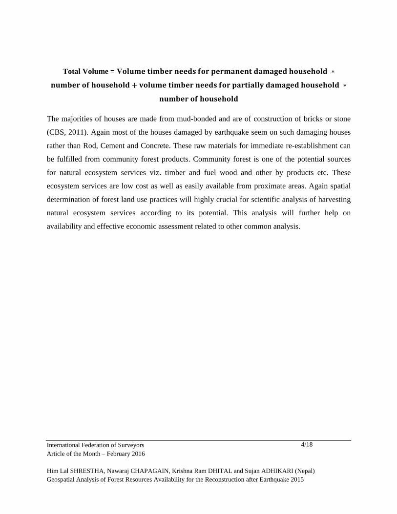
Total Volume = V
The majorities of houses are made from mud-bonded and are of construction of bricks or stone
(CBS, 2011). Again most of the houses damaged by earthquake seem on such damaging houses
rather than Rod, Cement and Concrete. These raw materials for immediate re-establishment can
be fulfilled from community forest products. Community forest is one of the potential sources
for natural ecosystem services viz. timber and fuel wood and other by products etc. These
ecosystem services are low cost as well as easily available from proximate areas. Again spatial
determination of forest land use practices will highly crucial for scientific analysis of harvesting
natural ecosystem services according to its potential. This analysis will further help on
availability and effective economic assessment related to other common analysis.
International Federation of Surveyors
Article of the Month – February 2016
Him Lal SHRESTHA, Nawaraj CHAPAGAIN, Krishna Ram DHITAL and Sujan ADHIKARI (Nepal)
Geospatial Analysis of Forest Resources Availability for the Reconstruction after Earthquake 2015
5/18
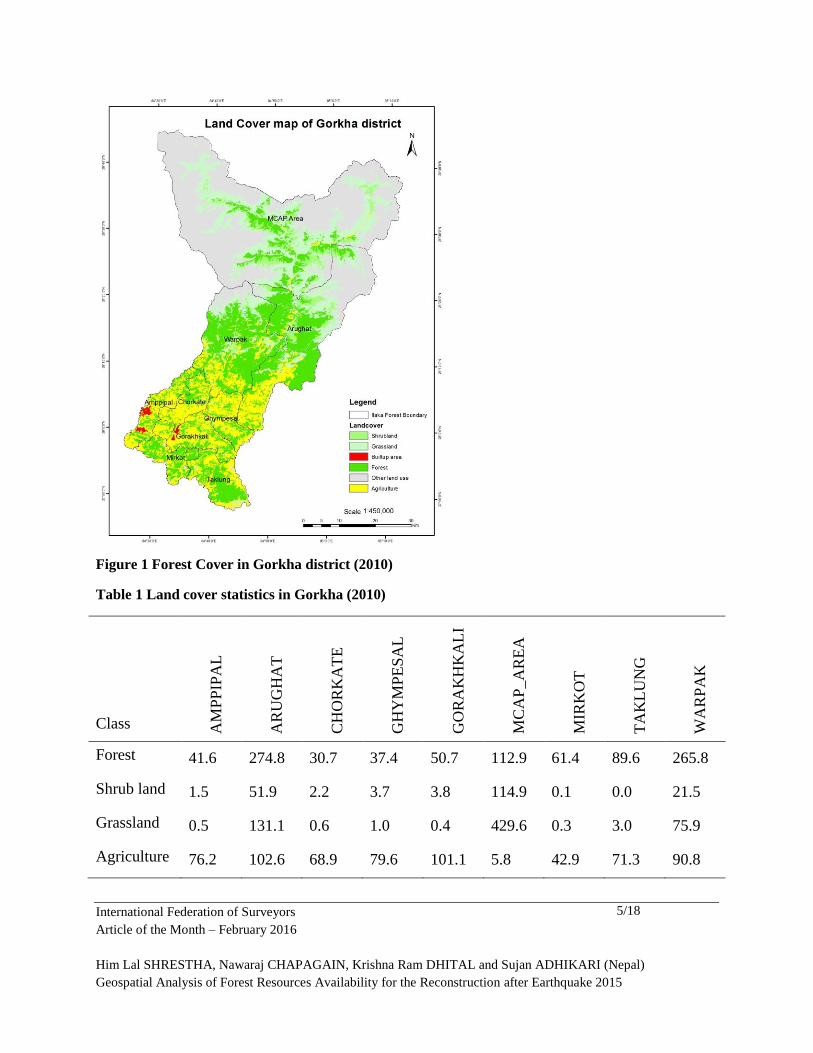
Figure 1 Forest Cover in Gorkha district (2010)
Table 1 Land cover statistics in Gorkha (2010)
Class AM
PP
IPA
L
AR
UG
HA
T
CH
OR
KA
TE
GH
YM
PE
SA
L
GO
RA
KH
KA
LI
MC
AP
_A
RE
A
MIR
KO
T
TA
KL
UN
G
WA
RP
AK
Forest 41.6 274.8 30.7 37.4 50.7 112.9 61.4 89.6 265.8
Shrub land 1.5 51.9 2.2 3.7 3.8 114.9 0.1 0.0 21.5
Grassland 0.5 131.1 0.6 1.0 0.4 429.6 0.3 3.0 75.9
Agriculture 76.2 102.6 68.9 79.6 101.1 5.8 42.9 71.3 90.8
International Federation of Surveyors
Article of the Month – February 2016
Him Lal SHRESTHA, Nawaraj CHAPAGAIN, Krishna Ram DHITAL and Sujan ADHIKARI (Nepal)
Geospatial Analysis of Forest Resources Availability for the Reconstruction after Earthquake 2015
6/18
Other 0.1 149.7 0.0 0.8 0.4 969.8 2.1 6.4 42.2
Builtup area 8.5 0.0 0.7 0.0 2.8 0.0 0.0 0.0 0.0
To recover from current disaster analysis of living situation of the people, reconstruction of the
damaged structure and other parameters are very crucial. Construction of damaged private and
social infrastructures require large amount of timber; which will directly affected by its
availability and accessibility from forest land and other land use practices. So it is necessary to
analyze the present growing stock of timber, demand in terms of proximities. This paper tries to
assess the current scenario of the stock and demand ratio with respect to reconstruction unit of
timber from the point of view in different Ilaka of Gorkha district’s forest. Which ultimately try
to examine the recent government decisions regarding the collection, sale and distribution of
timber from Chure range. This will be a challenging issue with consideration of environmental
degradation, due to fragile ecosystem of Chure forest.
OBJECTIVES OF STUDY:
Overall objective of this research is to assure availability and its potentialities of Timber
extraction and growing stock determination from all community forest of Gorkha districts, its
spatial distribution analysis to mitigate local people in terms of timber demand for physical
structures re establishing.
International Federation of Surveyors
Article of the Month – February 2016
Him Lal SHRESTHA, Nawaraj CHAPAGAIN, Krishna Ram DHITAL and Sujan ADHIKARI (Nepal)
Geospatial Analysis of Forest Resources Availability for the Reconstruction after Earthquake 2015
7/18
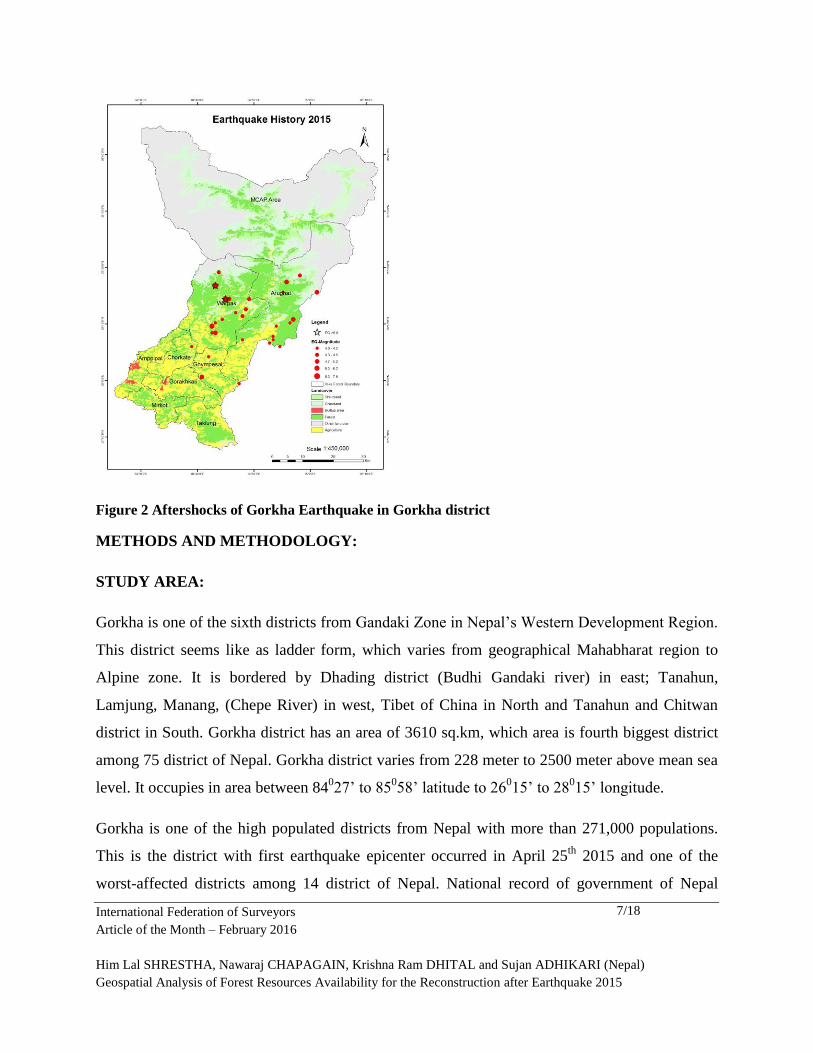
Figure 2 Aftershocks of Gorkha Earthquake in Gorkha district
METHODS AND METHODOLOGY:
STUDY AREA:
Gorkha is one of the sixth districts from Gandaki Zone in Nepal’s Western Development Region.
This district seems like as ladder form, which varies from geographical Mahabharat region to
Alpine zone. It is bordered by Dhading district (Budhi Gandaki river) in east; Tanahun,
Lamjung, Manang, (Chepe River) in west, Tibet of China in North and Tanahun and Chitwan
district in South. Gorkha district has an area of 3610 sq.km, which area is fourth biggest district
among 75 district of Nepal. Gorkha district varies from 228 meter to 2500 meter above mean sea
level. It occupies in area between 84027’ to 85
058’ latitude to 26
015’ to 28
015’ longitude.
Gorkha is one of the high populated districts from Nepal with more than 271,000 populations.
This is the district with first earthquake epicenter occurred in April 25th
2015 and one of the
worst-affected districts among 14 district of Nepal. National record of government of Nepal
International Federation of Surveyors
Article of the Month – February 2016
Him Lal SHRESTHA, Nawaraj CHAPAGAIN, Krishna Ram DHITAL and Sujan ADHIKARI (Nepal)
Geospatial Analysis of Forest Resources Availability for the Reconstruction after Earthquake 2015
8/18
shows that, up to September last 449 no of people were killed from this devastating disaster. The
majority of houses from this district are made by mud-bonded and constructed of bricks or stone
(GoN, 2011). Wood is the main sources of energy for cooking purposes in this district (CBS
2011).
METHODS:
This study was based on both secondary data collection from different published and
unpublished recent earthquake related articles by different NGO, INGO’s, Cabinet decision of
GoN, Forest data from District forest office such as: Growing stock and Allowable cut,
potentiality of timber production at community forest of Gorkha district and another was Spatial
data relationship from forest land use of Gorkha district by using Arc GIS tool.
Firstly, Gorkha district was divided into 8 Ilaka forests and one MCA region. Ilaka may be a
group of VDC/Municipality which is considered as a basic unit provided by District Forest
Office. Secondly, geospatial analysis of all Ilaka forest was done by using Arc GIS 10.1
software. Now, The supply and demand of the timber were compared according to its
potential/capacity by reviewing accessibility of physical infrastructures such as road terrain,
slope, altitude, aspect, labor potential etc. These data was further analyzed by comparing total
current timber demand by allowable cut, according to CF Operational Plan. Once deficiency
oftimber demand are further fulfilled by considering either increasing in allowable cut or by
considering as certain duration timeline for infrastructure reconstruction in future years.
Average demand of timber, allowable cut, average growing stock and other relationships were
analyzed through Microsoft tool, other spatial relationship like demarcation, buffering, distance
measurement were analyzed by ARC GIS 10.
RESULTS AND DISCUSSIONS:
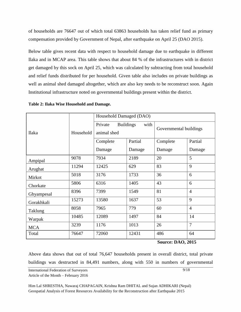
1. Ilaka Wise Household with shed damage and Governmental buildings damage:
According to last census recorded by CBS Gorkha 2014, total household recorded in Gorkha
district is with 66506 numbers with 271061 populations. But, According to DAO Gorkha total no
International Federation of Surveyors
Article of the Month – February 2016
Him Lal SHRESTHA, Nawaraj CHAPAGAIN, Krishna Ram DHITAL and Sujan ADHIKARI (Nepal)
Geospatial Analysis of Forest Resources Availability for the Reconstruction after Earthquake 2015
9/18
of households are 76647 out of which total 63863 households has taken relief fund as primary
compensation provided by Government of Nepal, after earthquake on April 25 (DAO 2015).
Below table gives recent data with respect to household damage due to earthquake in different
Ilaka and in MCAP area. This table shows that about 84 % of the infrastructures with in district
get damaged by this sock on April 25, which was calculated by subtracting from total household
and relief funds distributed for per household. Given table also includes on private buildings as
well as animal shed damaged altogether, which are also key needs to be reconstruct soon. Again
Institutional infrastructure noted on governmental buildings present within the district.
Table 2: Ilaka Wise Household and Damage.
Ilaka Household
Household Damaged (DAO)
Private Buildings with
animal shed Governmental buildings
Complete
Damage
Partial
Damage
Complete
Damage
Partial
Damage
Ampipal 9078 7934 2189 20 5
Arughat 11294 12425 629 83 9
Mirkot 5018 3176 1733 36 6
Chorkate 5806 6316 1405 43 6
Ghyampesal 8396 7399 1549 81 4
Gorakhkali 15273 13580 1637 53 9
Taklung 8058 7965 779 60 4
Warpak 10485 12089 1497 84 14
MCA 3239 1176 1013 26 7
Total 76647 72060 12431 486 64
Source: DAO, 2015
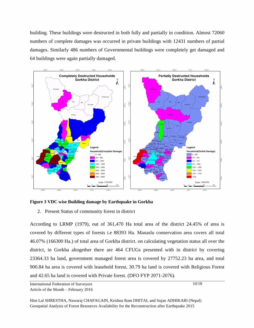
Above data shows that out of total 76,647 households present in overall district, total private
buildings was destructed in 84,491 numbers, along with 550 in numbers of governmental
International Federation of Surveyors
Article of the Month – February 2016
Him Lal SHRESTHA, Nawaraj CHAPAGAIN, Krishna Ram DHITAL and Sujan ADHIKARI (Nepal)
Geospatial Analysis of Forest Resources Availability for the Reconstruction after Earthquake 2015
10/18
building. These buildings were destructed in both fully and partially in condition. Almost 72060
numbers of complete damages was occurred in private buildings with 12431 numbers of partial
damages. Similarly 486 numbers of Governmental buildings were completely get damaged and
64 buildings were again partially damaged.
Figure 3 VDC wise Building damage by Earthquake in Gorkha
2. Present Status of community forest in district
According to LRMP (1979), out of 361,470 Ha total area of the district 24.45% of area is
covered by different types of forests i.e 88393 Ha. Manaslu conservation area covers all total
46.07% (166300 Ha.) of total area of Gorkha district. on calculating vegetation status all over the
district, in Gorkha altogether there are 464 CFUGs presented with in district by covering
23364.33 ha land, government managed forest area is covered by 27752.23 ha area, and total
900.84 ha area is covered with leasehold forest, 30.79 ha land is covered with Religious Forest
and 42.65 ha land is covered with Private forest. (DFO FYP 2071-2076).
International Federation of Surveyors
Article of the Month – February 2016
Him Lal SHRESTHA, Nawaraj CHAPAGAIN, Krishna Ram DHITAL and Sujan ADHIKARI (Nepal)
Geospatial Analysis of Forest Resources Availability for the Reconstruction after Earthquake 2015
11/18
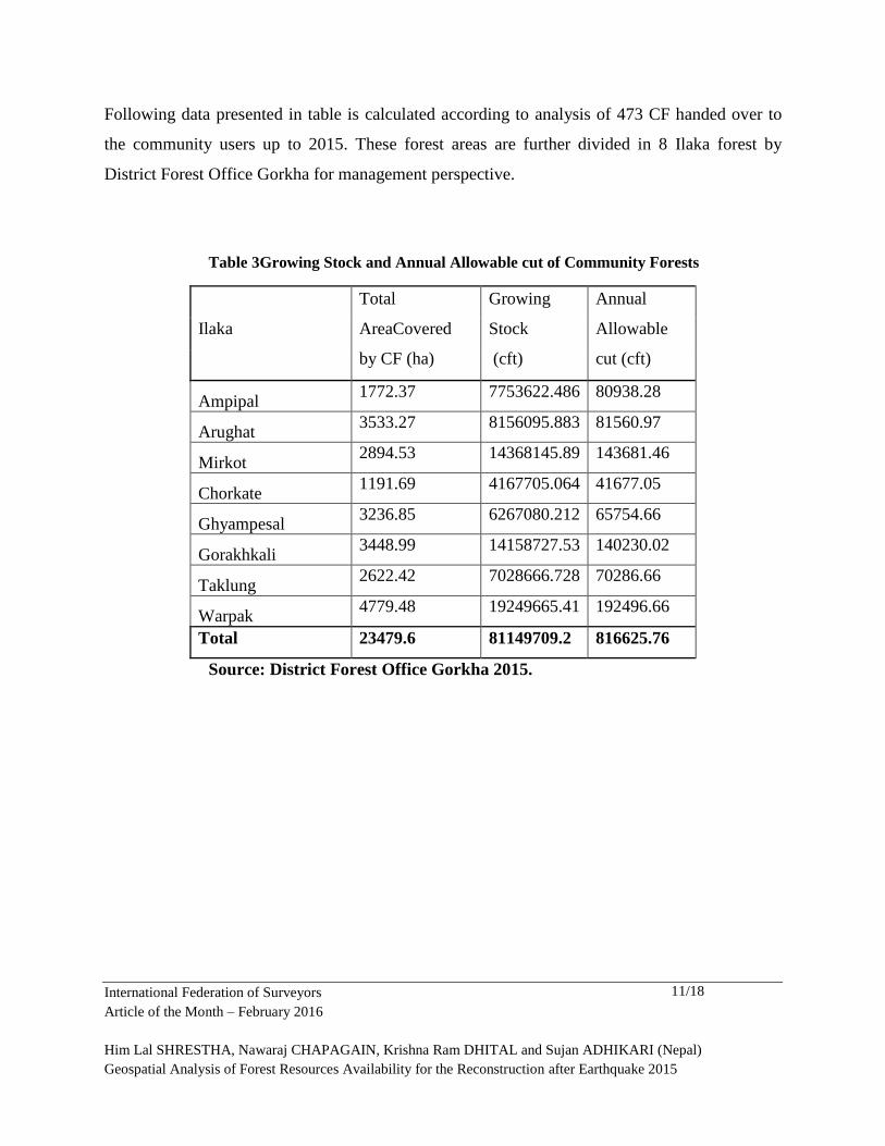
Following data presented in table is calculated according to analysis of 473 CF handed over to
the community users up to 2015. These forest areas are further divided in 8 Ilaka forest by
District Forest Office Gorkha for management perspective.
Table 3Growing Stock and Annual Allowable cut of Community Forests
Ilaka
Total
AreaCovered
by CF (ha)
Growing
Stock
(cft)
Annual
Allowable
cut (cft)
Ampipal 1772.37 7753622.486 80938.28
Arughat 3533.27 8156095.883 81560.97
Mirkot 2894.53 14368145.89 143681.46
Chorkate 1191.69 4167705.064 41677.05
Ghyampesal 3236.85 6267080.212 65754.66
Gorakhkali 3448.99 14158727.53 140230.02
Taklung 2622.42 7028666.728 70286.66
Warpak 4779.48 19249665.41 192496.66
Total 23479.6 81149709.2 816625.76
Source: District Forest Office Gorkha 2015.
International Federation of Surveyors
Article of the Month – February 2016
Him Lal SHRESTHA, Nawaraj CHAPAGAIN, Krishna Ram DHITAL and Sujan ADHIKARI (Nepal)
Geospatial Analysis of Forest Resources Availability for the Reconstruction after Earthquake 2015
12/18
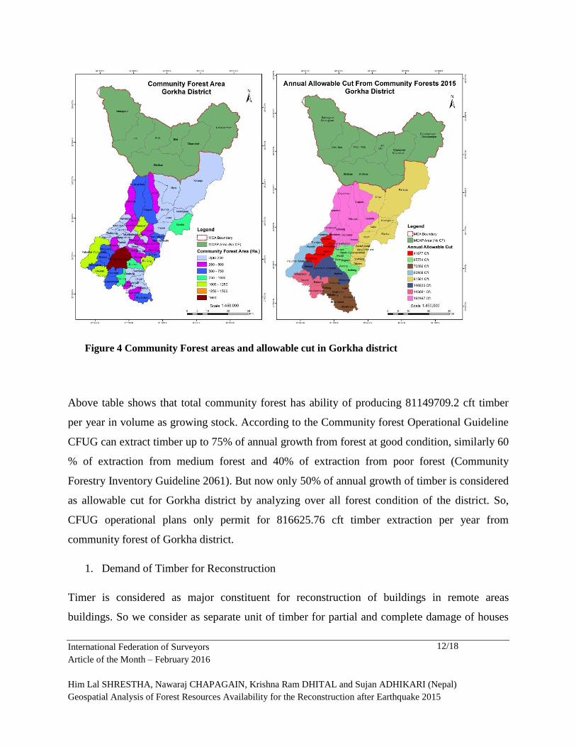
Figure 4 Community Forest areas and allowable cut in Gorkha district
Above table shows that total community forest has ability of producing 81149709.2 cft timber
per year in volume as growing stock. According to the Community forest Operational Guideline
CFUG can extract timber up to 75% of annual growth from forest at good condition, similarly 60
% of extraction from medium forest and 40% of extraction from poor forest (Community
Forestry Inventory Guideline 2061). But now only 50% of annual growth of timber is considered
as allowable cut for Gorkha district by analyzing over all forest condition of the district. So,
CFUG operational plans only permit for 816625.76 cft timber extraction per year from
community forest of Gorkha district.
1. Demand of Timber for Reconstruction
Timer is considered as major constituent for reconstruction of buildings in remote areas
buildings. So we consider as separate unit of timber for partial and complete damage of houses
International Federation of Surveyors
Article of the Month – February 2016
Him Lal SHRESTHA, Nawaraj CHAPAGAIN, Krishna Ram DHITAL and Sujan ADHIKARI (Nepal)
Geospatial Analysis of Forest Resources Availability for the Reconstruction after Earthquake 2015
13/18
as well partial and complete damage of institutional buildings. In considering this Government of
Nepal, Ministry of Forest and Soil Conservation, Department of Forest has prolonged a
operational plan to reconstruct such physical structures, in this operational plan department has
mentioned as 50 cft for complete damages houses and 20 cft for partial damages houses.
Similarly for institutional buildings it has considered as 100cft for complete damages and 40 cft
for partial damages. But according toinformation provided from District Forest Office Gorkha,
Forest office can only provide 30 cft timbers for complete damage buildings and 20 cft timbers
for partial damages buildings.
Scenario 1: This scenario 1st speaks on distribution of timber for earthquake damaged private and
governmental buildings and it’s overcome of demand in certain period of time, according to
decision of Department of Forest, Kathmandu Nepal.
According to the decision made by of Department of Forest, average timber demand distribution
on completely damaged buildings will preferred for 50 cft and 20 cft for partial damaged
buildings. Again 100 cft will allocated for completely damaged governmental buildings and 40
cft timber for partially damaged governmental buildings.
Table 4Timber demand according to the Department direction
Illaka
Timber Demand ccording to DOF Babarmahal
Private Government Grand
Total Complete Partial Total Complete Partial Total
Ampipal 396700 43780 440480 2000 200 2200 442680
Arughat 621250 12580 633830 8300 360 8660 642490
Mirkot 158800 34660 193460 3600 240 3840 197300
Chorkate 315800 28100 343900 4300 240 4540 348440
Ghyampesal 369950 30980 400930 8100 160 8260 409190
Gorakhkali 679000 32740 711740 5300 360 5660 717400
Taklung 398250 15580 413830 6000 160 6160 419990
Warpak 604450 29940 634390 8400 560 8960 643350
MCA 58800 20260 79060 2600 280 2880 81940
Total 3603000 248620 3851620 48600 2560 51160 7805560
International Federation of Surveyors
Article of the Month – February 2016
Him Lal SHRESTHA, Nawaraj CHAPAGAIN, Krishna Ram DHITAL and Sujan ADHIKARI (Nepal)
Geospatial Analysis of Forest Resources Availability for the Reconstruction after Earthquake 2015
14/18
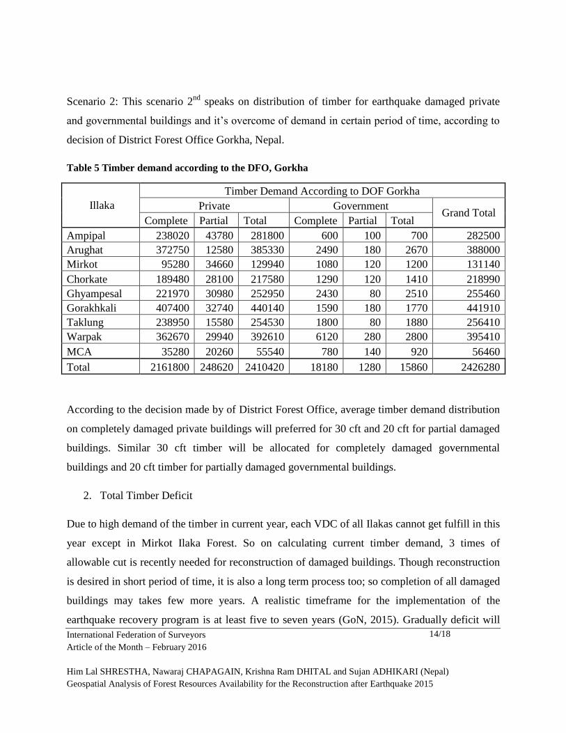
Scenario 2: This scenario 2nd
speaks on distribution of timber for earthquake damaged private
and governmental buildings and it’s overcome of demand in certain period of time, according to
decision of District Forest Office Gorkha, Nepal.
Table 5 Timber demand according to the DFO, Gorkha
Illaka
Timber Demand According to DOF Gorkha
Private Government Grand Total
Complete Partial Total Complete Partial Total
Ampipal 238020 43780 281800 600 100 700 282500
Arughat 372750 12580 385330 2490 180 2670 388000
Mirkot 95280 34660 129940 1080 120 1200 131140
Chorkate 189480 28100 217580 1290 120 1410 218990
Ghyampesal 221970 30980 252950 2430 80 2510 255460
Gorakhkali 407400 32740 440140 1590 180 1770 441910
Taklung 238950 15580 254530 1800 80 1880 256410
Warpak 362670 29940 392610 6120 280 2800 395410
MCA 35280 20260 55540 780 140 920 56460
Total 2161800 248620 2410420 18180 1280 15860 2426280
According to the decision made by of District Forest Office, average timber demand distribution
on completely damaged private buildings will preferred for 30 cft and 20 cft for partial damaged
buildings. Similar 30 cft timber will be allocated for completely damaged governmental
buildings and 20 cft timber for partially damaged governmental buildings.
2. Total Timber Deficit
Due to high demand of the timber in current year, each VDC of all Ilakas cannot get fulfill in this
year except in Mirkot Ilaka Forest. So on calculating current timber demand, 3 times of
allowable cut is recently needed for reconstruction of damaged buildings. Though reconstruction
is desired in short period of time, it is also a long term process too; so completion of all damaged
buildings may takes few more years. A realistic timeframe for the implementation of the
earthquake recovery program is at least five to seven years (GoN, 2015). Gradually deficit will
International Federation of Surveyors
Article of the Month – February 2016
Him Lal SHRESTHA, Nawaraj CHAPAGAIN, Krishna Ram DHITAL and Sujan ADHIKARI (Nepal)
Geospatial Analysis of Forest Resources Availability for the Reconstruction after Earthquake 2015
15/18
be recovered as the reconstruction time frame extends. In next 3 years the following deficit
timber can be extracted from community forests to fulfill over all timber demand. On depending
on Community Forest, no other sources are needed to fulfill the local demand if the
reconstruction process is extended for few years.
Timber deficit 2015 is calculated by subtracting the Annual allowable cut from total timber
needed for reconstruction. Timber deficit in 2016, 2017 and 2018 is calculated by subtracting the
timber deficit from their respective previous year.
Table 6 Situation of timber demand and supply in Gorkha district
Illaka
Annual
Allowabl
e cut
(c.f.t)
DFO
Sheet
Total Timber
Needed for
reconstruction(Cf
t)
Timber
Deficit
(Cft.) by
2015
2016 2017 2018
Ampipal 80938.28 282500 201561.72 120623.44 39685.16 -41253.12
Arughat 81560.97 388000 306439.03 224878.06 143317.09 61756.12
Mirkot
143681.4
6 131140 -12541.46
-
143681.46
-
143681.46
-
143681.46
Chorkate 41677.05 218990 177312.95 135635.9 93958.85 52281.8
Ghyampesa
l 65754.66 255460 189705.34 123950.68 58196.02 -7558.64
Gorakhkali
140230.0
2 441910 301679.98 161449.96 21219.94
-
119010.08
Taklung 70286.66 256410 186123.34 115836.68 45550.02 -24736.64
Warpak
192496.6
6 395410 202913.34 10416.68
-
182079.98
-
192496.66
MCA 56460 56460 56460 56460 56460
Total
816625.7
6 2426280
1609654.2
4 805569.94 132625.64
-
358238.68
Table 7 Deficit and Surplus status till Five Years
Illaka Timber
Deficit
Timber
Deficit
Timber
Deficit
Timber
Deficit
Timber
Deficit
Timber
Deficit
International Federation of Surveyors
Article of the Month – February 2016
Him Lal SHRESTHA, Nawaraj CHAPAGAIN, Krishna Ram DHITAL and Sujan ADHIKARI (Nepal)
Geospatial Analysis of Forest Resources Availability for the Reconstruction after Earthquake 2015
16/18
This year
(Cft.)
2015
Next
year(after
one year)
2016
After Two
year 2017
After three
year 2018
After
four year
2019
After Five
year 2020
Ampipal 201561.72 120623.44 39685.16 -41253.12 -122191.4 -203129.68
Arughat 306439.03 224878.06 143317.09 61756.12 -19804.85 -101365.82
Mirkot -12541.46 -156222.92 -299904.38 -443585.84 -587267.3 -730948.76
Chorkate 177312.95 135635.9 93958.85 52281.8 10604.75 -31072.3
Ghyampesal 189705.34 123950.68 58196.02 -7558.64 -73313.3 -139067.96
Gorakhkali 301679.98 161449.96 21219.94 -119010.08 -259240.1 -399470.12
Taklung 186123.34 115836.68 45550.02 -24736.64 -95023.3 -165309.96
Warpak 202913.34 10416.68 -182079.98 -374576.64 -567073.3 -759569.96
MCA 56460 56460 56460 56460 56460 56460
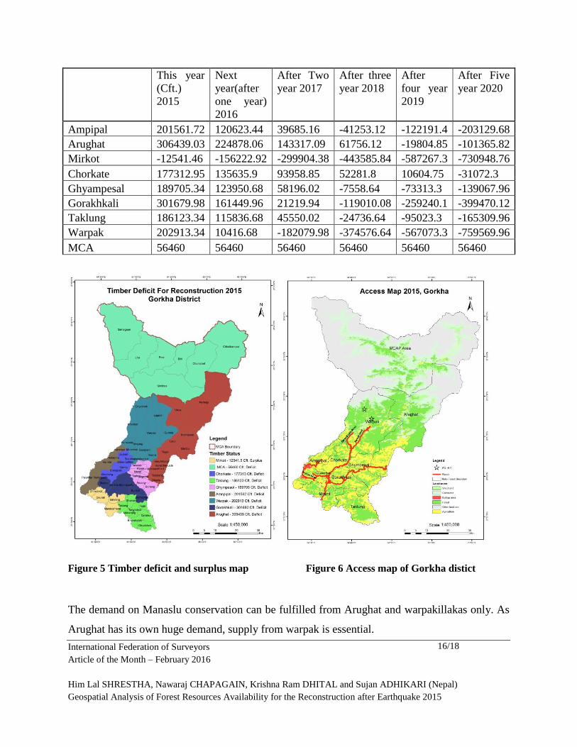
Figure 5 Timber deficit and surplus map Figure 6 Access map of Gorkha distict
The demand on Manaslu conservation can be fulfilled from Arughat and warpakillakas only. As
Arughat has its own huge demand, supply from warpak is essential.
International Federation of Surveyors
Article of the Month – February 2016
Him Lal SHRESTHA, Nawaraj CHAPAGAIN, Krishna Ram DHITAL and Sujan ADHIKARI (Nepal)
Geospatial Analysis of Forest Resources Availability for the Reconstruction after Earthquake 2015
17/18
Mirkot has its surplus from this year so it can be mobilized to adjoining illakas like Taklung,
Anpipal, and Gorakhkali. Ampipal Ilaka can fulfill their demand by 2018, Arughat Illaka by
2019, Chorkate by 2020, Ghympesol,Gorakhkali and Taklung, by 2018,warpak by 2017with
surplus 41253 cft,19804 cft, 143681 cft, 31072cft, 7558cft, 119010 cft, 24736 cft, 192496 cft
respectively. In case of Mirkot Illaka, their demand this year is less than annual allowable cut so
they can fulfill demand this year with surplus timber 12541.5 cft. And in Manaslu Conservation
Area 56460 cft of timber must be fulfilled from other Illaka because we cannot harvest from this
areas forest.
CONCLUSION
In conclusion, the results from this study shows that the need of the timber supply for the
reconstruction of buildings caused by earthquake 2015 can be fulfilled from the local sources of
timber such as National forest, community forests and private forests in Gorkha. The enabling
environment for the timber harvest and the transportation needed to be analyzed further. The
sustainable harvest of the timber from the forest areas in the district can fullfil the local demand
of the timber in Gorkha district within three years which ultimately the sustain the forest areas in
the district as well as it will protect the environmentally important wood lots such as Chure
region, if we have devised the proper plan of timber harvest linking with the nature of local
demand of the timber viz. Urban people and rural people may have different need of the timber,
people may not need entire demand of timber at the same time. The timber need may be
categorized as of 3 months, 6 months, 1 year, 2 years and 3 years from the earthquake
devastation. The other important management consideration should be the use of previous woods
from the old building.
ACKNOWLEDGEMENT
Authors would like to acknowledge eG-Tech Pvt. Ltd. for necessary resources to conduct this
study. We also want to acknowledge District Forest Office and District Administration Office,
Gorkha for making necessary field data available.
International Federation of Surveyors
Article of the Month – February 2016
Him Lal SHRESTHA, Nawaraj CHAPAGAIN, Krishna Ram DHITAL and Sujan ADHIKARI (Nepal)
Geospatial Analysis of Forest Resources Availability for the Reconstruction after Earthquake 2015
18/18
REFERENCES
1. CBS (2014). District profile, Gorkha.
2. DFO (2014). Five Year Forest Sector Plan of Gorkha District. pp 116.
3. GoN (2015a). Nepal Earthquake 2015: Post Disaster Needs Assessment. Vol A: key
Findings. pp 134.
4. GoN (2015b). Nepal Earthquake 2015: Post Disaster Needs Assessment. Vol B: Sectors
reports. pp 312.
5. Paudel, G., Bishowokarma.,Paudel, N.S., (2015). Government decision on relaxing Chure
Timber Supply to address post-earthquake reconstruction Demand: A sensible decision or
just a gesture? pp 4.
6. Hashemi, M., Alesheikh, A.A., (2011). A GIS-based earthquake damage assessment and
settlement methodology. Soil Dynamics and Earthquake Engineering, V 31(11), pp1607-
1617.
7. Liu, J.G., Mason, P.J., Yu, E., Wu, M.C., Tang, C., Huang, R., Liu, H., (2012). GIS
modeling of earthquake damage zones using satellite remote sensing and DEM data.
Geomorphology, V 139-140(2012), 518-535.
8. Hassanzadeh, R., Nedovic-Budic, Z., Razavi, A.A., Norouzzadeh, M., Hodhodkian, H.,
(2013). Interactive approach for GIS-based earthquake scenario development and
resource estimation (Karmania hazard model). Computers and Geosciences, V 51(2013),
pp 324-338.
9. Bhattacharya, S., Hyodo, M., Goda, K., Tazoh, T., Taylor, C.A., (2011). Liquefaction of
soil in the Tyoko Bay area from the 2011 Tohoku (Japan) earthquake. Soil Dynamics and
Earthquake Engineering, V 31(11), pp 1618-1628.
10. Dong, Yanfang., Li, Qi., Dou, Aixia., Wang, Xiaoqing., (2011). Extracting damages
caused by the 2008 Ms 8.0 Wenchuan earthquake from SAR remote sensing data. Journal
of Asian Earth Sciences, V 40(4), pp 907-914.
11. Erdik, M., Sesetyan, K., Demircioglu, M.B., Hancilar, U., Zulfikar., (2011). Rapid
earthquake loss assessment after damaging earthquakes. Soil Dynamics and Earthquake
Engineering, V 31(2), pp 247-266.
12. Liu, Huan., Cui, Ximin., Yuan, D., Wang, Z., Jin, J., Wang, M., (2011). Study of
Earthquake isaster Population Risk Based on GIS. Procedia Enviromental Sciences, V
11(2011), pp 1084-1091.