Mastering Security with GeoServer and GeoFence - FOSS4G 2016

GeoServer: Past, Present and Future
Andrea Aime - OpenGeoJustin Deoliveira - OpenGeo

• Releases since FOSS4G 2007• GeoServer 1.6.0 vs GeoServer 1.7.0
– feature comparison– performance comparison
One year at a glance

One year of releasesSEPT 07 OCT 07 NOV 07 DEC 07
JAN 08 FEB 08 MAR 08 APR 08
MAY 08 JUN 08 JUL 08
AUG 08
1.6.0-beta3WMS speed-ups
SEPT 08
1.5.4Bug fixes
1.6.2Security fixes
1.6.3WatermarkingLimit SRS listKML speed-ups
1.6.4Bug fixes
1.7.0-beta1Per layer securityWCS 1.1.1WFS 1.1 + xlink
1.7.0-beta2More per layer security optionsKML superoverlays
1.7.0-RC1Bug fixesGDAL based readers 1.7.0-RC2
Bug fixes1.7.0-RC3Bug fixes
1.6.0Security fixes
1.6.0-beta4Bug fixes
1.6.0-RC1Bug fixes
1.6.0-RC2Bug fixes
1.6.0-RC3Bug fixes
1.6.5Bug fixes

Geo
Serv
er
WFS 1.0
WMS 1.1
PostGISDB2OracleMySql
Shapefile---------------------------------------
---------------------------------------
---------------------------------------
ArcSDEWFS
PNG, GIFJPEGTIFF, GeoTIFFSVG, PDFKML/KMZ
Shapefile.zipGML2GML3GeoRSSGeoJSONRaw vector
data
Servers
Styled maps
DBMS
Vector files
WFS 1.1
WCS 1.0GeoTIFF
ArcGridGTopo30Img+worldMosaicPyramid
Raster files
Raw rasterdata
GeoTIFFArcGridGTopo30Img+World
1.6.0 beta3

Geo
Serv
erG
eoW
ebC
ache
WFS 1.0
WMS 1.1
PostGISDB2OracleMySql
Shapefile---------------------------------------
---------------------------------------
---------------------------------------
ArcSDEWFS
PNG, GIFJPEGTIFF, GeoTIFFSVG, PDFKML/KMZ
Shapefile.zipGML2GML3GeoRSSGeoJSONCSV/XLS
Raw vectordata
Servers
Styled maps
DBMS
Vector files
WFS 1.1
WCS 1.0
GeoTIFFArcGridGTopo30Img+worldMosaicMrSIDJPEG 2000ECW,Pyramid
Raster files
Raw rasterdata
GeoTIFFArcGridGTopo30Img+World
1.7.0
WCS 1.1
GWCKML superoverlaysGoogle maps tiles

• Using JMeter to generate load against a local GeoServer Using a XP Pro box, 3GB memory, 3Ghz dual core processor
• Rising number of concurrent requests, reports average response time (lower bars are better)
1 10 20 400
50
100
150
200
250
300
350
400
450
2140
164
402
13 16
80
305
1.6.0-beta3 1.7.0
Number of concurrent requests
Res
pons
e tim
e in
ms
Quick performance comparison
• WMS requests against a shapefile layer (the topp:states demo layer, see the benchmark presentation for details)
• Using 6 different tiles of 256x256 size, png encoding, antialiasing

Quick performance comparison
1 10 20 400
100
200
300
400
500
600
20
90
226
507
14
62
151
360
1.6.0-beta3 1.7.0-RC3
Number of concurrent requests
Res
pons
e tim
e in
ms
• WFS requests against a PostGIS layer (a copy of the topp:states demo layer, same 6 tiles but in GML)
1 10 20 400
100
200
300
400
500
600
700
800
900
1000
24
220
480
912
16
132
297
670
1.6.0-beta3 1.7.0-RC3
Number of concurrent requests
Res
pons
e tim
e in
ms
• WMS requests against a 6000x4800 GeoTiff, extracting 256x256 tiles at various resolutions

• Per layer security• WFS reprojection• GDAL raster drivers, raster symbolizer• GeoWebCache, KML SuperOverlays• ...
New features in detail

Per layer security• Ability to specify access rule on a layer by layer
basis• Simple configuration based on a list of rules
following this template:namespace.layer.mode=role1,role2,...
A name, or * tomean “any”
r: readw: write
The roles that willbe authorized to access the dataunder this rule

Per layer security, example
*.*.r=**.*.w=NO_ONEprivate.*.r=TRUSTED_ROLEprivate.*.w=TRUSTED_ROLEtopp.districts.w=LEGISLATORS
private.* topp.*
TRUSTED_ROLE r/w r r r(no access) r r/w r(no access) r r r
topp.districts
Other layers
LEGISLATORS (all other users)
Basic read only lock down
Per layer overrides

GDAL integration• By means of the ImageIO-ext library,
GeoServer can now support MrSID, JPEG 2000, ECW and a subset of other GDAL supported formats
• Requires platform dependent binary extensions, available only for Windows and Linux at the moment (contributions welcomed!)
• Very good performance, see the benchmark related presentation
• ECW reader not included in the standard download due to licensing issues
geo-solutions.it

Raster symbolizer support• Significantly improved, now supports:
– color ramp– band selection– contrast enhancement– opacity and gamma correction
Extractgray
channel
Applycolormap
geo-solutions.it

Default grayscale DEM outputDefault grayscale DEM output
Applying a ColorMapApplying a ColorMap
DataSource: GTOPO30 in a single file, JPEG2000 losslessDataSource: GTOPO30 in a single file, JPEG2000 losslesscompression, 166.392x21.587 pixels, 386MB (ftp://ftp.microimages.com/pub/outgoing/data/jp2/)compression, 166.392x21.587 pixels, 386MB (ftp://ftp.microimages.com/pub/outgoing/data/jp2/)

GeoWebCache integration
GeoServer
GeoWebCache
Persistent raster/KMLtile cache
• Caches tiles as used by most common slippy map interfaces
• Ideal for layers that rarely change
• Delivers raster/KML tiles to:– OpenLayers– Google Maps and Google
Earth– Microsoft Virtual Earth
• Speeds up data delivery by a factor or 10-100

KML SuperOverlays• Problem: you have a huge data set you want to
display on Google Earth– the generated KML is simply too big– the features you want to display have a clear
hierarchy– zoomed out, you want to display only the most
important ones, – less important should appear progressively, as
you zoom in, while leaving the important ones visible
– of course, everything should happen in the most fluid way

KML SuperOverlays •Solution–create a pyramid like structure–have Google Earth regions drive what is visible at each scale–use a tile cache to maximize delivery speed•This requires GeoServer 1.7.0 and the GeoWebCache plug-in

KML superoverlays
A sample from the global biodiversity database (www.gbif.org), distribution of the Cape Hope Squid (Loligo Vulgaris Reynaudi)

Improved preview• Play with tiling, antialiasing, format and map
size• Issue dynamic filters on your data

Other improvements• Significant ArcSDE improvements
– Less connections used during normal operation– Supports versioning, read and write against the
default version– Uses native ArcSDE transactions on write
• Support for Xlink in WFS 1.1
• Fully new WCS 1.1 module (GeoServer being the reference implementation of it)

• New user interface• REST configuration API• Brand new Oracle data store• N-dimensional rasters• WPS 1.0• and more...
What's cooking?

New user interface• Developed in collaboration with interface and
interaction designers• Fully AJAX based• Most functionality within a few clicks from the
root of the administration interface• Service extensions can now plug in their extra
configuration UI• Based on the open source Wicket framework
(wicket.apache.org)

New user interface

REST configuration• Prototype worked on during the last year• Allows full programmatic configuration using
simple REST calls (e.g., mass configuring 100 layers, adding new data as it comes in, etc.).
• Will be further developed in the 2.0.x series

New Oracle data store• Current Oracle data store giving you
headaches? Try the new one:– Full rewrite– Deeper testing– No more date/time/timestamp issues– Better security– Better performance– Support for some 3D geometry structures
• The base for a new series of database backed data stores (yes, PostGIS, I'm looking at you!)

Forget flat rasters...• Support for N-dimensional coverages (3d + time)• Full WCS support, mapping slices using WMS
time and elevation parameters • Being coded right now in a branch
geo-solutions.it

SLD visual editor

Web Processing Service 1.0• A new WPS 1.0 plug-in is sitting in the
GeoServer community area• Finally some spatial analysis!• At the moment, only sample processes
– simple addition– geometry union, intersection
• But with an API that allows you to build new ones, so jump in!
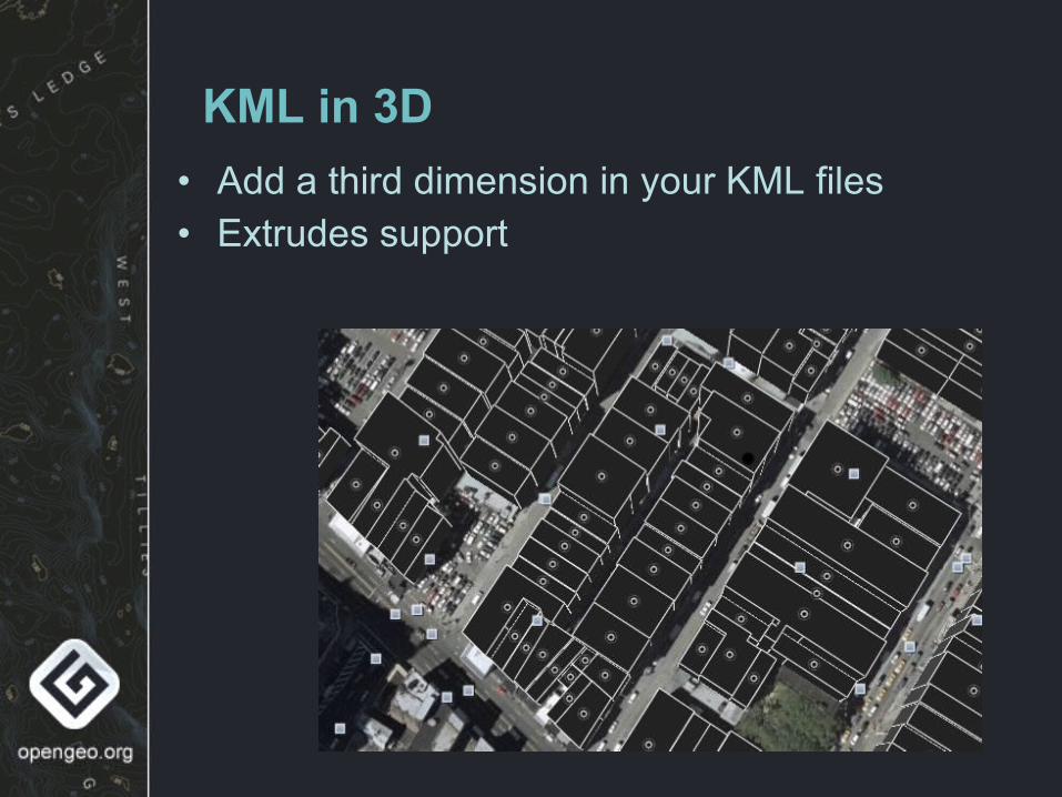
KML in 3D• Add a third dimension in your KML files• Extrudes support

And more!• Google searchable datasets:
– Following the KML super-overlays work, make the datasets searchable by Google
– Very interesting if you need to disseminate big amounts of data in a way that allows most people to find them and import them in Google Earth
• Complex features– CSIRO (http://www.csiro.au/) is poking GeoServer in
an attempt to add complex features– Next year might come with big suprises

QUESTIONS?

• Because I always want to say more than what presentation time allows for...
Extra slides

WFS: full reprojection support• Have your client work in a completely different
projection than the data native one:– Reproject WFS output to another spatial
reference system – Insert data in SRS other than the native one– Express filters in an SRS other than the native
one• E.g., make a OpenLayers web based editing
client and use Google tiles (in spheric mercator projection) as a backdrop
• Works even with WFS 1.0 (as a custom extension)

GeoServer(back and forth on the fly reprojection)
Google Mapsservers
OpenLayers
Vectordata
(4326)
Backgroundtiles
GetFeature(geometries in 900913)
Rasterdata
(4326)
Transaction(geometries in 900913)
GetMap
(custom background overlays)

Security: access modes
Geo
Serv
erGetCapabilities
R1
GetMap (securedLayer)R2
Hide Challenge Mixed
GetCaps All layers R1
GetMap Layer is not there R2
Only layers current user can see
Only layers current user can see
Cannot access, authenticate again
Cannot access, authenticate again
Clie
nt

Security sandwich
WMS WMS WCS WPS
Data catalog
Customprotocols
OGC service security layer
Data security layer