Geoscientists Without Borders® Program
15
Geoscientists Without Borders® Program The Haiti Subsurface Imaging Project – Year 1 Report Date: October 21st, 2013 Title: The Haiti Subsurface Imaging (HASI) Project: Helping build Haiti’s geoscience capability and searching for the 2010 earthquake fault Project Location: Léogâne, Haiti Lead Organization: University of Houston Team members: Robert Stewart, Paul Mann, Eray Kocel, Anoop William, Naila Dowla, and Li Chang - University of Houston; Nathan Babcock - Chesapeake, Oklahoma City; Craig Hyslop, ExxonMobil Production Research, Houston; Soumya Roy, WesternGeco, Houston; Matt Hornbach, Southern Methodist University, Dallas; Don Lawton, University of Calgary Julon Pochette, Nicole Dieudonné - Bureau des Mines et de L'Énergie d'Haiti Alexander von Lignau, Savannah Savary – Haitian logistics
Transcript of Geoscientists Without Borders® Program
12
Geoscientists Without Borders® Program
The Haiti Subsurface Imaging Project – Year 1 Report
Date: October 21st, 2013
Title: The Haiti Subsurface Imaging (HASI) Project: Helping build Haiti’s
geoscience capability and searching for the 2010 earthquake fault
Project Location: Léogâne, Haiti
Lead Organization: University of Houston
Team members: Robert Stewart, Paul Mann, Eray Kocel, Anoop William, Naila
Dowla, and Li Chang - University of Houston; Nathan Babcock - Chesapeake, Oklahoma City; Craig Hyslop, ExxonMobil Production Research, Houston; Soumya Roy, WesternGeco, Houston; Matt Hornbach, Southern Methodist University, Dallas; Don Lawton, University of Calgary
Julon Pochette, Nicole Dieudonné - Bureau des Mines et de L'Énergie d'Haiti
Alexander von Lignau, Savannah Savary – Haitian logistics

3 | P a g e
The Haiti Subsurface Imaging (HASI) Project:
Helping build Haiti’s geoscience capability and
searching for the 2010 earthquake fault
OVERVIEW
On January 12, 2010 Haiti suffered a major earthquake with subsequent and tragic human and
infrastructural loss. Surface expression of the earthquake fault has not yet been unambiguously
found. Thus, key geologic components of the devastating event are not well resolved. The Haiti
Subsurface Imaging (HASI) Project aspires to find expression of this “blind” fault. In doing so,
we are attempting to help with the building of geophysical capability and personnel development
in Haiti.
This report documents progress made on the HASI Project over Year 1 (2012-2013) with the
generous support of the Geoscientists Without Borders (GWB) program and SEG Foundation.
As proposed in our 2011 submission to the GWB Program, a University of Houston (UH) team
undertook an unfunded reconnaissance visit to Haiti in January, 2012 (Phase 1). Our team - Drs.
Robert Stewart and Paul Mann, plus UH graduate students, Nathan Babcock and Li Chang - was
able to coordinate our visit with a United Nations-sponsored Haiti Earthquake Memorial
Conference in Port-au-Prince on January 12, 2012, exactly two years after the devastating 2010
earthquake. We met with a number of geoscience counterparts in the USGS, Haitian Bureau of
Mines and Energy (BME), and other geosciences institutes. We next undertook a reconnoitering
trip to the Léogâne Delta to find appropriate surveying sites near the earthquake epicentral area.
We were accompanied and aided by Haitian colleagues from the BME, local professionals, and
villagers at the survey site. We subsequently conducted geophysical (GPS, total station, gravity,
and seismic) surveys in the Delta area. We established a solid working relationship with Haitian
personnel. The geophysical data acquired were of good quality and the area was promising for
further investigation.
Based upon these reconnaisance surveys, we returned to Haiti in February, 2013 (Phase 2).
Global Geophysical of Houston kindly lent us 100 seismic station nodes for this effort. The US
team included Drs. Stewart and Mann, UH staff members Li Chang and Anoop William, along
with UH Ph.D. student, Eray Kocel. We encountered a number of logistical challenges in Haiti,
but after several days were able to assemble our equipment, team, and transportation. We were
joined by our Haitian colleagues from the BME. We next undertook GPS and gravity surveys
near Port-au-Prince, then ten days of seismic, GPS, and gravity surveys in the Léogâne Delta.
We were able to employ some 20 local villagers and provide instruction to them about seismic
surveys, instruments, and deployment. We also encountered several aid groups in the Léogâne
area and have offered them all of our survey information to assist with their development efforts.
4 | P a g e
As a result of the surveys, we have found some fascinating evidence of surface faulting. We have
prepared a number of abstracts, posters, and videos from this work.
Further east along the main Enriquillo-Plantain Garden Fault zone, lies Lake Enriquillo. Drs.
Paul Mann and Matt Hornbach returned to Hispaniola in May, 2013 to undertake sonar
measurements on the Lake. Their surveys produced a number of transects that provide exciting
details of the main faults.
These three reconnoitering surveys have delivered excellent results relevant to our quest to
image the subsurface in search for evidence of the 2010 earthquake. We anticipated that the top
of the blind fault could be some several kilometers deep. While our shallow, short seismic lines
show some evidence of faulting, the image is not clear and the discontinuities are not necessarily
part of a larger fault system required to create the 2010 earthquake. Thus, as originally proposed,
we must return and image deeper in the section (Phase 3). This requires a larger seismic source
(vibrating truck or heavier weight drop). We plan to return to Haiti in the winter of 2014 and ship
a larger seismic source to Haiti. In addition, we will have acquired significantly more lake
surveying capability with new side-scan sonar, boomer, and chirp systems. We will deploy and
use these instruments in Haiti.
Geophysics is providing an excellent pathway for understanding Haiti’s geology and hazards,
helping build technical capacity, further assisting in the development of Haitian personnel, and
providing an intensely useful experience for an international group of students. For the 2014
(third) stage of this Haiti Project, we anticipate significant development advances and geologic
insight.
INTRODUCTION
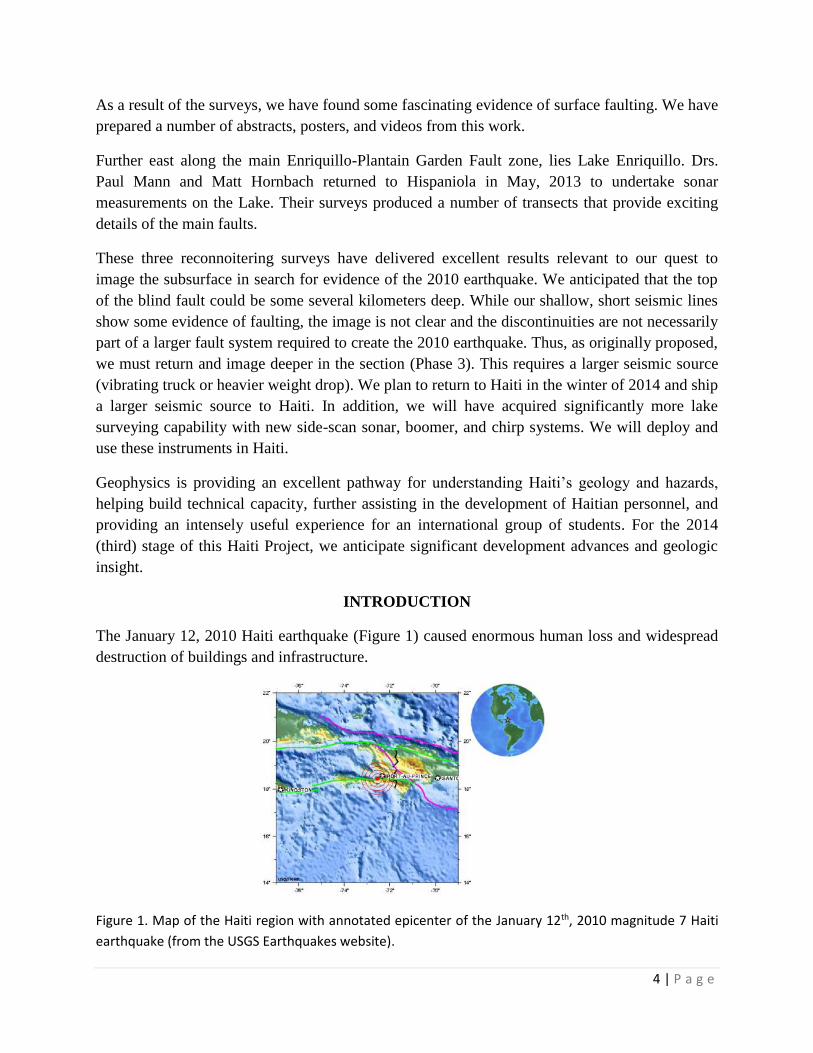
The January 12, 2010 Haiti earthquake (Figure 1) caused enormous human loss and widespread
destruction of buildings and infrastructure.
Figure 1. Map of the Haiti region with annotated epicenter of the January 12th, 2010 magnitude 7 Haiti
earthquake (from the USGS Earthquakes website).
5 | P a g e
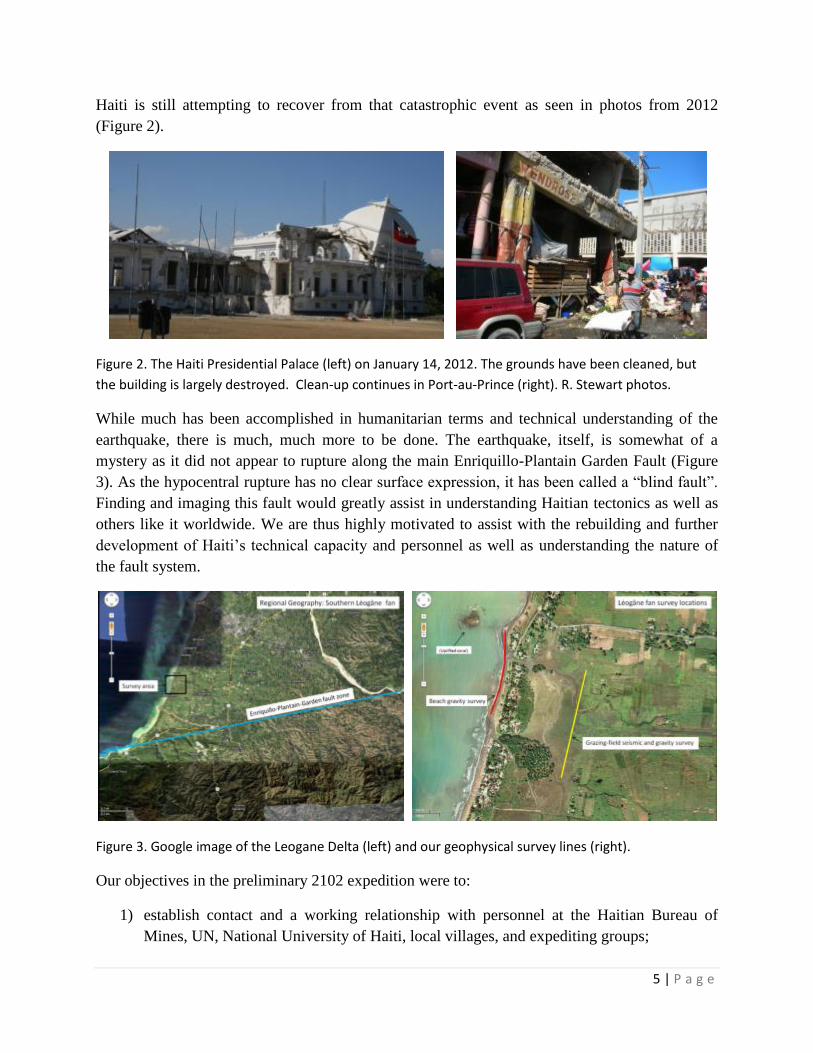
Haiti is still attempting to recover from that catastrophic event as seen in photos from 2012
(Figure 2).
Figure 2. The Haiti Presidential Palace (left) on January 14, 2012. The grounds have been cleaned, but
the building is largely destroyed. Clean-up continues in Port-au-Prince (right). R. Stewart photos.
While much has been accomplished in humanitarian terms and technical understanding of the
earthquake, there is much, much more to be done. The earthquake, itself, is somewhat of a
mystery as it did not appear to rupture along the main Enriquillo-Plantain Garden Fault (Figure
3). As the hypocentral rupture has no clear surface expression, it has been called a “blind fault”.
Finding and imaging this fault would greatly assist in understanding Haitian tectonics as well as
others like it worldwide. We are thus highly motivated to assist with the rebuilding and further
development of Haiti’s technical capacity and personnel as well as understanding the nature of
the fault system.
Figure 3. Google image of the Leogane Delta (left) and our geophysical survey lines (right).
Our objectives in the preliminary 2102 expedition were to:
1) establish contact and a working relationship with personnel at the Haitian Bureau of
Mines, UN, National University of Haiti, local villages, and expediting groups;

6 | P a g e
2) scout the Léogâne Delta Fan (2010 Haitian earthquake epicentral) region for evidence of
surface rupture and determine logisitics for geophysical surveys;
3) undertake geophysical tests using shallow seismic and gravity techniques.
We chronicle the results of this expedition below.
RECONNOITER - JANUARY, 2012
We organized the Haiti reconnaissance mission over the period of September, 2011 to January,
2012. Armed with inoculations and geophysical equipment, we (Drs. Paul Mann, Rob Stewart
and UH graduate students, Nathan Babcock and Li Chang) departed from Houston to Port-au-
Prince via Fort Lauderdale. Due to time constraints, we flew all of our equipment with us as
excess baggage. Fortunately, it did all arrive intact. We were able to import the equipment with
minimal delay in Haiti due to sponsoring support and documentation from Dr. Dieuseul Anglade,
General Director of the BME. On January 12, 2012, there was a 2010 Earthquake Memorial
Conference in Port-au-Prince and major overview of the earthquake. We were introduced to
many of the individuals and organizations (USGS, UN, BME, NUH) who are involved in
ongoing efforts to understand the earthquake and mitigate the effects of future events. Drs. Paul
Mann and Rob Stewart made presentations at the Memorial Conference. We are currently
corresponding with Dr. Carol Prentice of the USGS and Dr. Eric Calais of Purdue University
who are involved in Haitian tectonic studies. We also began coordinating with a major proposed
French-Spanish marine cruise to be conducted off shore Haiti in 2013 (currently delayed).
Figure 4. Geophysical team (Paul Mann, left; Nathan Babcock, center; and Rob Stewart, right) in Port-au-
Prince, Haiti preparing to scout the epicentral area.
With the expert assistance of Haitian colleagues Alexander von Lignau and Savannah Savary, we
established a working base near the Léogâne epicenter area. We spoke with the local villagers
who have much of the Delta Fan area under cultivation and received permission to survey on
7 | P a g e
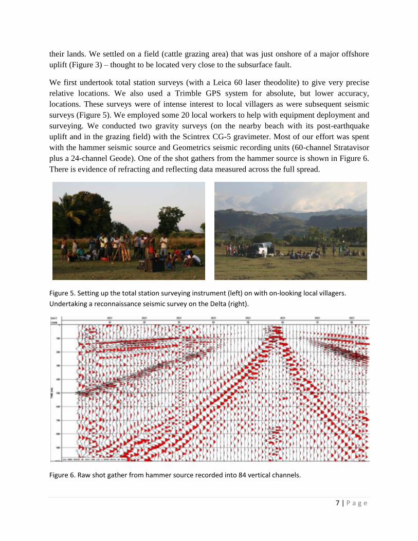
their lands. We settled on a field (cattle grazing area) that was just onshore of a major offshore
uplift (Figure 3) – thought to be located very close to the subsurface fault.
We first undertook total station surveys (with a Leica 60 laser theodolite) to give very precise
relative locations. We also used a Trimble GPS system for absolute, but lower accuracy,
locations. These surveys were of intense interest to local villagers as were subsequent seismic
surveys (Figure 5). We employed some 20 local workers to help with equipment deployment and
surveying. We conducted two gravity surveys (on the nearby beach with its post-earthquake
uplift and in the grazing field) with the Scintrex CG-5 gravimeter. Most of our effort was spent
with the hammer seismic source and Geometrics seismic recording units (60-channel Stratavisor
plus a 24-channel Geode). One of the shot gathers from the hammer source is shown in Figure 6.
There is evidence of refracting and reflecting data measured across the full spread.
Figure 5. Setting up the total station surveying instrument (left) on with on-looking local villagers.
Undertaking a reconnaissance seismic survey on the Delta (right).
Figure 6. Raw shot gather from hammer source recorded into 84 vertical channels.

8 | P a g e
A major portion of this project is dedicated to capacity building in Haiti as well as student
engagement and education. Students at the University of Houston have processed these Haiti
data and the seismic data are available online. Preliminary results are shown in Figures 7 and 8.
We were very pleased that even with the relatively low energy hammer source, we can still see to
about 400 m depth in the subsurface. There is even some indication of near-surface faulting at
CMP 150. We are continuing to analyse and interpret these data. An accelerated weight drop
source could perhaps image reflectors at 1000 m depth. Our mini-vibe (controlled vibratory
truck) may well be able to image reflectors much deeper - at several kilometers depth. We are
very excited that this Delta Fan looks to be a very good seismic data area. This gives hope that
we may be able to image some of the earthquake fault zone.
Figure 7. Velocity analysis and NMO correction on CMP hammer seismic gather (left). Velocities range from 1200 – 2300 m/s. Stacking velocity section (right).
Figure 8. Brute stack section converted to depth. Note that there is evidence of reflections from about
400 m depth using the hammer seismic source.
9 | P a g e
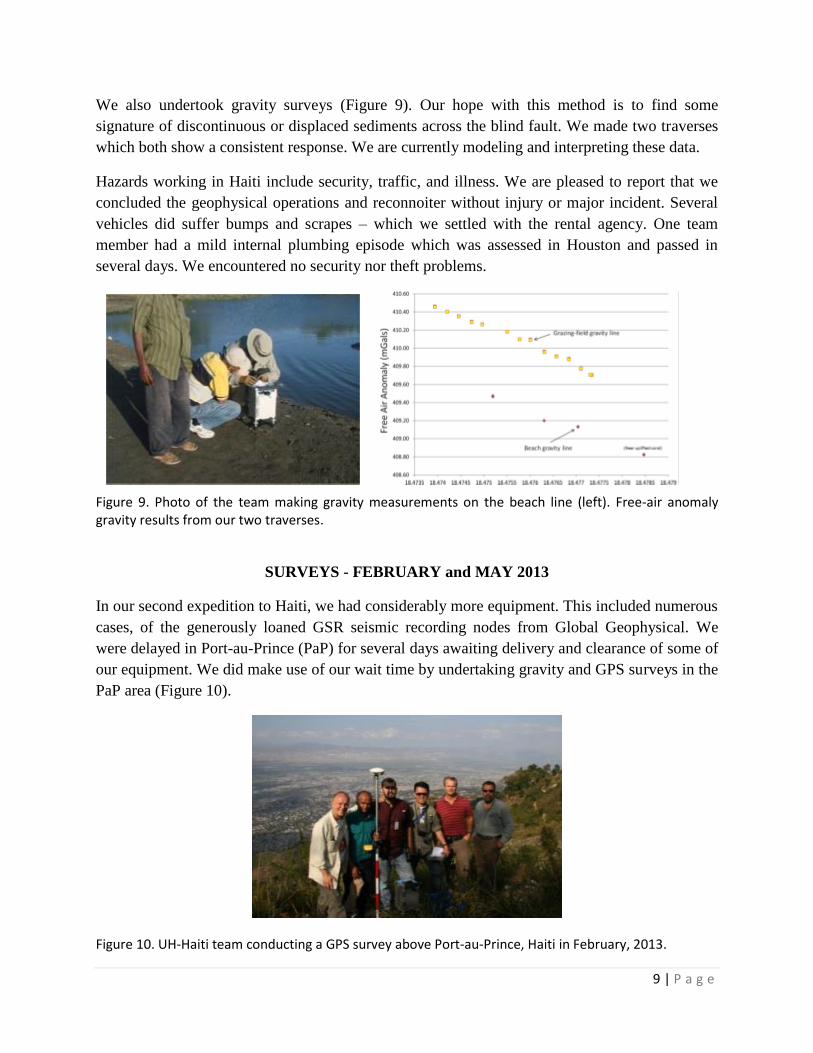
We also undertook gravity surveys (Figure 9). Our hope with this method is to find some
signature of discontinuous or displaced sediments across the blind fault. We made two traverses
which both show a consistent response. We are currently modeling and interpreting these data.
Hazards working in Haiti include security, traffic, and illness. We are pleased to report that we
concluded the geophysical operations and reconnoiter without injury or major incident. Several
vehicles did suffer bumps and scrapes – which we settled with the rental agency. One team
member had a mild internal plumbing episode which was assessed in Houston and passed in
several days. We encountered no security nor theft problems.
Figure 9. Photo of the team making gravity measurements on the beach line (left). Free-air anomaly gravity results from our two traverses.
SURVEYS - FEBRUARY and MAY 2013
In our second expedition to Haiti, we had considerably more equipment. This included numerous
cases, of the generously loaned GSR seismic recording nodes from Global Geophysical. We
were delayed in Port-au-Prince (PaP) for several days awaiting delivery and clearance of some of
our equipment. We did make use of our wait time by undertaking gravity and GPS surveys in the
PaP area (Figure 10).
Figure 10. UH-Haiti team conducting a GPS survey above Port-au-Prince, Haiti in February, 2013.

10 | P a g e
Once again, there were reasonable concerns about health (especially cholera – see Figure 11) and
safety, but we did not encounter any problems.
Figure 11. Alertness to health (Kolera toujou la – Cholera is still there) and security matters are
important, but fortunately we encountered no problems.
After receiving all of our equipment and organizing vehicles and lodging, we departed for the
Léogâne Delta. We met with our BME colleagues and hired over 20 local helpers to assist with
equipment deployment (Figure 12).
Figure 12. We were able to employ several dozen local Haitian helpers in laying out the seismic lines and
equipment near Léogâne under the diligent supervison of our Haitian Bureau of Mines and Energy
colleagues.
We used two very different seismic recording systems: the autonomous nodes (GSRs generously
loaned to us by Global Geophysical, Houston) and our Geometrics Geode cabled recorders. In
addition, we had two sources: the GISCO slanted weight drop to excite both P and S waves as
well as the Propelled Energy Generator (Figure 13).
11 | P a g e
Figure 13. We used two different seismic sources in the 2013 surveys: A GISCO slanted weight drop (left)
and a PEG accelerated weight drop (right).
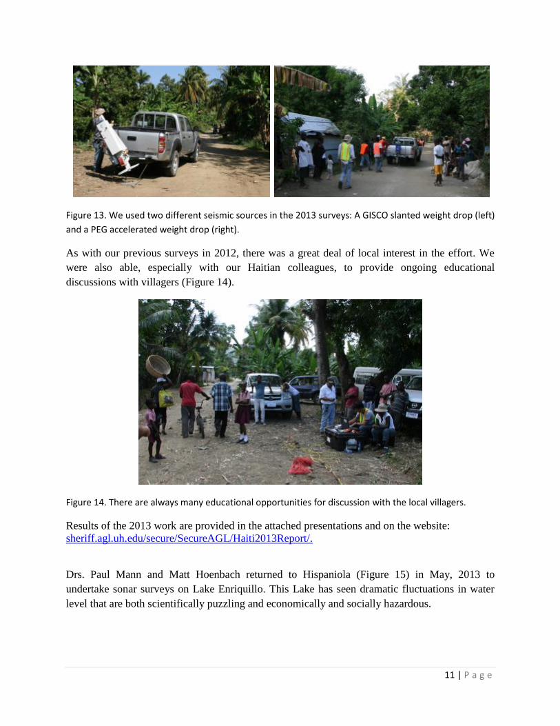
As with our previous surveys in 2012, there was a great deal of local interest in the effort. We
were also able, especially with our Haitian colleagues, to provide ongoing educational
discussions with villagers (Figure 14).
Figure 14. There are always many educational opportunities for discussion with the local villagers.
Results of the 2013 work are provided in the attached presentations and on the website:
sheriff.agl.uh.edu/secure/SecureAGL/Haiti2013Report/.
Drs. Paul Mann and Matt Hoenbach returned to Hispaniola (Figure 15) in May, 2013 to
undertake sonar surveys on Lake Enriquillo. This Lake has seen dramatic fluctuations in water
level that are both scientifically puzzling and economically and socially hazardous.
12 | P a g e
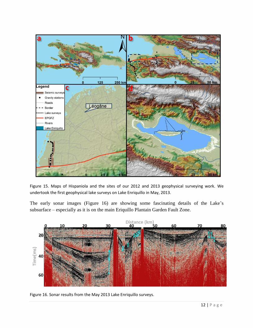
Figure 15. Maps of Hispaniola and the sites of our 2012 and 2013 geophysical surveying work. We
undertook the first geophysical lake surveys on Lake Enriquillo in May, 2013.
The early sonar images (Figure 16) are showing some fascinating details of the Lake’s
subsurface – especially as it is on the main Eriquillo Plantain Garden Fault Zone.
Figure 16. Sonar results from the May 2013 Lake Enriquillo surveys.
13 | P a g e
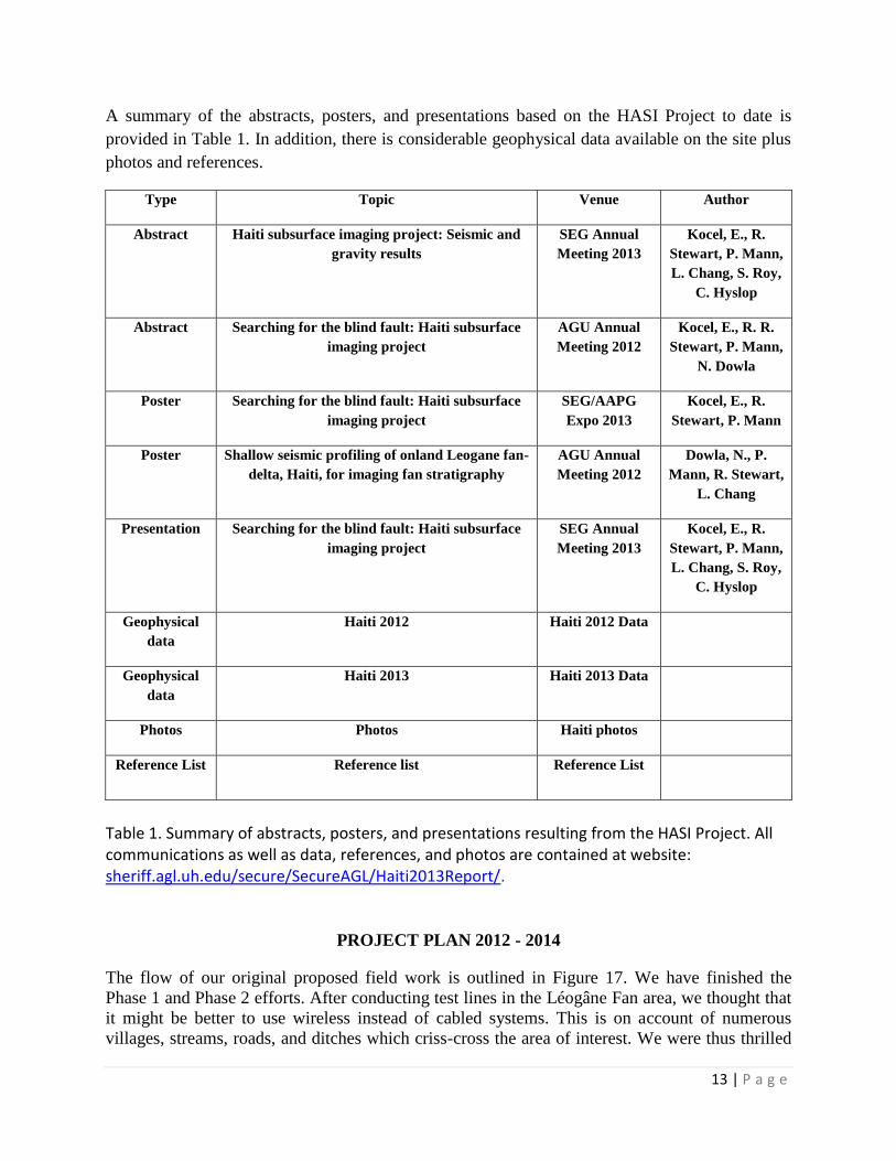
A summary of the abstracts, posters, and presentations based on the HASI Project to date is
provided in Table 1. In addition, there is considerable geophysical data available on the site plus
photos and references.
Type Topic Venue Author
Abstract Haiti subsurface imaging project: Seismic and
gravity results
SEG Annual
Meeting 2013
Kocel, E., R.
Stewart, P. Mann,
L. Chang, S. Roy,
C. Hyslop
Abstract Searching for the blind fault: Haiti subsurface
imaging project
AGU Annual
Meeting 2012
Kocel, E., R. R.
Stewart, P. Mann,
N. Dowla
Poster Searching for the blind fault: Haiti subsurface
imaging project
SEG/AAPG
Expo 2013
Kocel, E., R.
Stewart, P. Mann
Poster Shallow seismic profiling of onland Leogane fan-
delta, Haiti, for imaging fan stratigraphy
AGU Annual
Meeting 2012
Dowla, N., P.
Mann, R. Stewart,
L. Chang
Presentation Searching for the blind fault: Haiti subsurface
imaging project
SEG Annual
Meeting 2013
Kocel, E., R.
Stewart, P. Mann,
L. Chang, S. Roy,
C. Hyslop
Geophysical
data
Haiti 2012 Haiti 2012 Data
Geophysical
data
Haiti 2013 Haiti 2013 Data
Photos Photos Haiti photos
Reference List Reference list Reference List
Table 1. Summary of abstracts, posters, and presentations resulting from the HASI Project. All communications as well as data, references, and photos are contained at website: sheriff.agl.uh.edu/secure/SecureAGL/Haiti2013Report/.
PROJECT PLAN 2012 - 2014
The flow of our original proposed field work is outlined in Figure 17. We have finished the
Phase 1 and Phase 2 efforts. After conducting test lines in the Léogâne Fan area, we thought that
it might be better to use wireless instead of cabled systems. This is on account of numerous
villages, streams, roads, and ditches which criss-cross the area of interest. We were thus thrilled
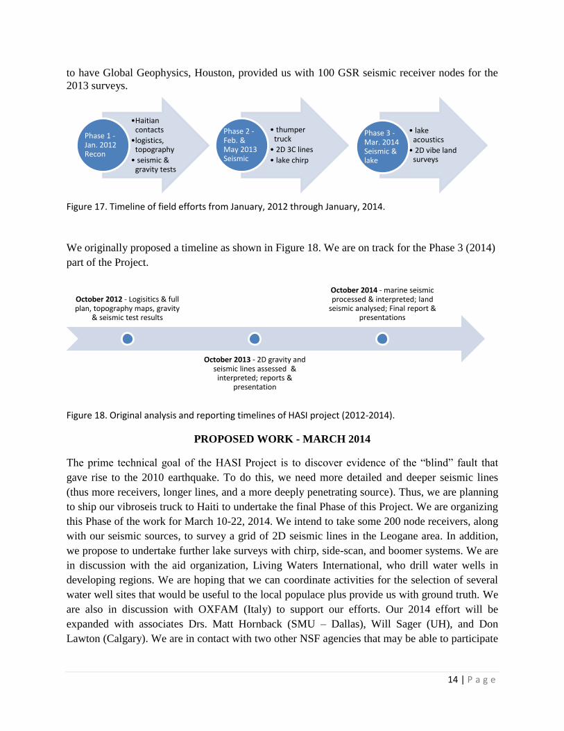
14 | P a g e
to have Global Geophysics, Houston, provided us with 100 GSR seismic receiver nodes for the
2013 surveys.
Figure 17. Timeline of field efforts from January, 2012 through January, 2014.
We originally proposed a timeline as shown in Figure 18. We are on track for the Phase 3 (2014)
part of the Project.
Figure 18. Original analysis and reporting timelines of HASI project (2012-2014).
PROPOSED WORK - MARCH 2014
The prime technical goal of the HASI Project is to discover evidence of the “blind” fault that
gave rise to the 2010 earthquake. To do this, we need more detailed and deeper seismic lines
(thus more receivers, longer lines, and a more deeply penetrating source). Thus, we are planning
to ship our vibroseis truck to Haiti to undertake the final Phase of this Project. We are organizing
this Phase of the work for March 10-22, 2014. We intend to take some 200 node receivers, along
with our seismic sources, to survey a grid of 2D seismic lines in the Leogane area. In addition,
we propose to undertake further lake surveys with chirp, side-scan, and boomer systems. We are
in discussion with the aid organization, Living Waters International, who drill water wells in
developing regions. We are hoping that we can coordinate activities for the selection of several
water well sites that would be useful to the local populace plus provide us with ground truth. We
are also in discussion with OXFAM (Italy) to support our efforts. Our 2014 effort will be
expanded with associates Drs. Matt Hornback (SMU – Dallas), Will Sager (UH), and Don
Lawton (Calgary). We are in contact with two other NSF agencies that may be able to participate
•Haitian contacts
•logistics, topography
• seismic & gravity tests
Phase 1 -Jan. 2012 Recon
• thumper truck
• 2D 3C lines
• lake chirp
Phase 2 -Feb. & May 2013 Seismic
• lake acoustics
• 2D vibe land surveys
Phase 3 -Mar. 2014 Seismic & lake
October 2012 - Logisitics & full plan, topography maps, gravity
& seismic test results
October 2013 - 2D gravity and seismic lines assessed &
interpreted; reports & presentation
October 2014 - marine seismic processed & interpreted; land
seismic analysed; Final report & presentations

15 | P a g e
in the 2014 expedition: the Seismic Consortium, IRIS – to lend seismic recording instruments
and the earthquake source network, NEES – to supply another vibrating truck.
Our budget includes expenditures for our Haitian colleagues ($3k), Haitian logistics coordinators
($4k), and local helpers ($3k). We will have a UH/SMU/UC team of four faculty, three students,
and three UH staff ($6k). These ten team members will incur transportation ($10k) and lodging
(two weeks at $14k) expenses. We will be return shipping a container of equipment, including
our vibe truck, to Haiti via surface vessel ($12k). There are equipment rental (accelerated weight
drop source from United Service Alliance @ $3k; Stratavisor from Geometrics @ $4k) and
instrument purchase costs ($5k). We will three rent trucks in Haiti ($6k including fuel). There
are numerous bonding, insurance, and other administrative costs ($3k). The Project cost is thus
$73,000. for the second year of the Project. The SEG Foundation previously and generously
awarded the Project a total of $49.5k for Year 2 upon receipt of acceptable Year 1 reports and
final Year 2 reports.
SUMMARY
A geophysical team from the University of Houston undertook a reconnaissance expedition to
Haiti on January 10-17, 2012. We were able to participate in the Haiti Earthquake Memorial
Conference in Port-au-Prince on the second anniversary of the 2010 event. We met there with a
number of members of Haitian and international aid and geosciences organizations. We
established a good working relationship with members of the Bureau of Mines and Energy as
well as a number of local logisitics experts. We reconnoitered the epicentral region of the 2010
earthquake and selected a site on the Léogâne Delta Fan for our surveys. We undertook detailed
total station, GPS, gravity, and seismic surveys in the Fan area. There was a productive and
pleasant interaction with local villagers in receiving access to survey areas and assistance with
operations. The quality of the 2012 data provided promise for more detailed surveys that we
undertook in February 2013. Again, we had excellent relations with our Haitian colleagues and
local people. Good GPS, gravity, and seismic data were acquired. There is some evidence of
faulting in the seismic sections from the Léogâne area. Another mission in May, 2013 to the
puzzling and hazardous Lake Enriquillo produced compelling sonar images illuminating the the
majoe faults zone. To further develop Haitian geophysical capabilities and create more detailed
and deeper seismic sections, we plan to return to Haiti in March, 2014. With Haitian help, we
hope to illuminate the blind fault, better understand the Haitian subsurface, and assist in
advancing Haiti’s technical capabilities.

16 | P a g e