Georgia Hurricane Plan - Georgia Emergency … Library/Hurricane Plan (2013).pdf · 5.0 CONCEPT OF...
127
2013 Georgia Hurricane Incident Annex Annex to: Georgia Emergency Operations Plan
Transcript of Georgia Hurricane Plan - Georgia Emergency … Library/Hurricane Plan (2013).pdf · 5.0 CONCEPT OF...

2013
Georgia Hurricane Incident Annex
Annex to: Georgia Emergency Operations Plan


Table of Contents 1.0 INTRODUCTION ..................................................................................................................................... 1
1.1 Purpose ..................................................................................................................................... 1
1.2 Scope ........................................................................................................................................ 1
1.3 Policies ...................................................................................................................................... 2
2.0 HAZARDS ANALYSIS ........................................................................................................................... 3
2.1 Potential Hazards ..................................................................................................................... 3
Tropical Cyclones ................................................................................................................ 3
Storm Surge ........................................................................................................................ 8
Wind .................................................................................................................................... 9
Inland Flooding .................................................................................................................. 10
Tornadoes ......................................................................................................................... 10
3.0 INCIDENT SITUATION ......................................................................................................................... 11
3.1 Incident Condition .................................................................................................................. 11
3.2 Planning Assumptions .......................................................................................................... 12
4.0 GEORGIA HURRICANE EVACUATION STUDY ................................................................................ 13
Hurricane Surge Inundation Zones ............................................................................................ 14
Hurricane Evacuation Zones ...................................................................................................... 15
Evacuation Clearance Time ........................................................................................................ 15
Evacuation Routes and Lane Reversal Plans ........................................................................... 15
5.0 CONCEPT OF OPERATIONS .............................................................................................................. 16
5.1 State Operating Conditions .................................................................................................. 16
OPCON 5 – Normal Operations and Atlantic Basin Monitoring ........................................ 17
OPCON 4 – Potential Impacts Within 120 Hours ............................................................. 17
OPCON 3 – Potential Impacts Within 72 Hours ............................................................... 18
OPCON 2 – Potential Impacts Within 48 Hours ............................................................... 18
OPCON 1 – Potential Impacts Within 24 Hours ............................................................... 18
5.2 Coordination ........................................................................................................................... 19
Federal and National Entities ............................................................................................ 19
Coordination within Georgia .............................................................................................. 20
Local Entities ..................................................................................................................... 21
Private-Sector Entities....................................................................................................... 22
Military/Department of Defense Entities............................................................................ 22

Volunteer Organizations ................................................................................................... 23
5.3 Command and Control .......................................................................................................... 23
5.4 SOC Augmented Support ...................................................................................................... 24
Evacuation and Re-entry Branch ...................................................................................... 24
Aviation Support Operations Center ................................................................................. 24
5.5 Evacuations ............................................................................................................................ 25
5.6 Sheltering ................................................................................................................................ 26
5.7 Re-Entry .................................................................................................................................. 28
5.8 Logistics ................................................................................................................................. 29
Logistics Staging Area ...................................................................................................... 30
Points of Distribution ......................................................................................................... 30
Emergency Power ............................................................................................................. 30
Fuel Support ...................................................................................................................... 31
5.9 Crisis Communications / Media Relations .......................................................................... 31
6.0 PLAN DEVELOPMENT AND MAINTENANCE ................................................................................... 33
7.0 REFERENCES ...................................................................................................................................... 34
Attachment 1: Key Terms and Definitions ......................................................................................... 1 of 2
Attachment 2: The Saffir-Simpson Hurricane Wind Scale ............................................................... 1 of 5
Attachment 3: Coastal Georgia Evacuation Scenarios .................................................................. 1 of 12
Appendix 1: State Operating Conditions (OPCONs) ...................................................................... 1 of 27
OPCON 5 – Normal Operations and Atlantic Basin Monitoring ................................................ 1
OPCON 4 – Potential Impacts Within 120 Hours ........................................................................ 3
OPCON 3 – Potential Impacts Within 72 Hours .......................................................................... 8
OPCON 2 – Potential Impacts Within 48 Hours ........................................................................ 14
OPCON 1 – Potential Impacts Within 24 Hours ........................................................................ 21
Appendix 2: Hurricane Evacuations ................................................................................................ 1 of 15
INTRODUCTION .............................................................................................................................. 1
AUTHORITIES ................................................................................................................................. 1
COORDINATION ............................................................................................................................. 2
EVACUATION STRATEGY ............................................................................................................. 3
EVACUATION SUPPORT ............................................................................................................... 7

Attachment 1 - Evacuation Clearance Times (charts) ......................................................... 1 of 2
Attachment 2: Coastal Georgia Evacuation Routes ............................................................ 1 of 2
Attachment 3: Gulf Coast Evacuation Routes ..................................................................... 1 of 3
Attachment 4: Georgia Public Broadcasting Radio Coverage ........................................... 1 of 2
Appendix 3: Post-Hurricane Re-Entry .............................................................................................. 1 of 10
INTRODUCTION .............................................................................................................................. 1
SITUATION ...................................................................................................................................... 2
CONCEPT OF OPERATIONS ......................................................................................................... 4
RE-ENTRY TASK FORCES AND SUPPORT STRIKE TEAMS..................................................... 6
PHASED RE-ENTRY ....................................................................................................................... 8
Phase I: Render Safe Task Force Team Entry ................................................................... 8
Phase II: Emergency Response and Life Safety Critical Workforce Re-Entry ................... 8
Phase IIA: Critical Workforce Conducting Life Safety Operations ...................................... 8
Phase IIB: Essential Infrastructure Emergency Support Personnel ................................... 9
Phase III: Local Residents, Property Owners, and Business Owners ................................ 9
Phase IV: Open to Public with Limited Access ................................................................... 9
ACCESS DURING RE-ENTRY ....................................................................................................... 9
RE-ENTRY ROUTES ..................................................................................................................... 10
Appendix 4: Geographic Area Command .......................................................................................... 1 of 9
INTRODUCTION .............................................................................................................................. 1
CONCEPT OF OPERATIONS ......................................................................................................... 2
Activation ............................................................................................................................. 2
Duties and Responsibilities ................................................................................................. 3
Staffing ................................................................................................................................ 3
Geographic Area Command Positions................................................................................ 3
Integration with SOC Operating Cycle ................................................................................ 6

Georgia Emergency Operational Plan Incident Annex: Hurricane CONPLAN
1
1 .0 In t roduct ion
The entire State of Georgia is vulnerable to tropical cyclone-related hazards. The
Georgia Hurricane Plan establishes the overarching framework for protective actions
pertaining to the preparedness, response, and initial recovery from hazards associated
with tropical cyclones.
Georgia has a long history of major impacts from tropical cyclones. This plan provides a
hazards analysis that quantifies the threat posed to Georgia by tropical cyclones. The
Georgia Hurricane Evacuation Study (HES), in conjunction with other sources, provides
scientific data that is utilized in the hazards analysis.
This plan outlines the framework for a coordinated and comprehensive response to
tropical cyclone-related impacts by disaster enterprise partners. The State Operating
Conditions (OPCONs) are designed to provide time-delineated and action-based trigger
points for requisite and remedial protective actions including the deployment of key
evacuation support resources, the staging and forward deployment of critical life
supportive commodities, and the broad-reaching coordination efforts that occur before
and after impacts are realized.
This plan serves as an update to the 2010 Georgia Hurricane Plan and incorporates
advances in disaster operation capabilities that were fostered through numerous
collaborative planning functions. Newly developed or refined capabilities in the plan
include logistical support, command and control, and enhanced initial re-entry
operations. The Georgia Hurricane Plan is compliant with the National Incident
Management System (NIMS) and National Response Framework (NRF).
1 . 1 Purpose It is the purpose of this Plan to define the actions and roles necessary to provide a
coordinated response within the State of Georgia. This Plan provides direction to
agencies within the State of Georgia with the guidelines of potential emergency
assignments before, during, and following emergency situations. It also provides for the
systematic integration of emergency resources when activated and does not replace
county or local emergency operations plans or procedures.
1 . 2 Scope The Georgia Hurricane Plan is a framework of protective actions for the preparation for,
response to, and initial recovery from a tropical cyclone impact. This plan provides an
overview of protective actions taken by disaster enterprise partners including federal,
state, local, military, volunteer, private-sector, and non-governmental organizations. The
plan presents operational strategies for pre-season preparedness and tropical cyclone

Georgia Emergency Operational Plan Incident Annex: Hurricane CONPLAN
2
tracking procedures, threat identification and coordination efforts, state-level evacuation
support, disaster logistical support, execution of a command and control strategy for
incident management, the types of forward operations facilities and their functions to be
utilized within the response framework, re-entry operations, and initial recovery
operations.
The overarching operational timeline presented in this plan (OPCONs) is referenced to
the arrival of tropical storm force winds (34 knots / 39 mph) at any location within the
state. This timeline has been developed with the intent of presenting protective actions
taken in major operational areas and is not intended to be an exhaustive list. The
timeline has been vetted with various disaster enterprise partners.
1 .3 Po l i c ies The Georgia Hurricane Plan is compliant with the NRF and the NIMS Incident Command
System (ICS) protocols.
The Georgia Hurricane Plan will be implemented by the Director of GEMA/HS, in
conjunction with the Georgia Emergency Operations Plan (GEOP), following the
declaration of a State of Emergency by the Governor of Georgia during the days
preceding potential impacts from a tropical cyclone.
All State resources utilized during a response will remain under the control of their
respective agency / department / organization. Federal resources will be requested by
the State to augment response capabilities. Federal resources requested by the State
may be subjected to cost sharing as dictated by the Robert T. Stafford Disaster Relief
and Emergency Assistance Act (the Stafford Act).
Additional disaster response plans may be initiated during a disaster response caused
by a tropical cyclone impact to Georgia. Plans that may be utilized include the following.
GEOP Incident Annex 2I-4: Georgia Energy Assurance Plan
GEOP Support Annex 2S-1: Logistics Support
GEOP Support Annex 2S-2: GEMA/HS Mutual Aid
GEOP Support Annex 2S-4: Statewide Sheltering Plan, draft
GEOP Support Annex 2S-5: Volunteer and Donations
Management GEOP Support Annex 2S-8: GEMA/HS Debris
Management
GEOP Support Annex 2S-10: Georgia Evacuee Support Plan
GEOP Support Annex 2S-11: Defense Support to Civil Authorities

Georgia Emergency Operational Plan Incident Annex: Hurricane CONPLAN
3
GEOP Standard Operating Guide 2-3: Special Needs Evacuation SOP
GEOP Standard Operating Guide 2-4: Aviation Support Operations Center
GEOP Standard Operating Guide 2-6: Defense Support to Civil Authorities
GEOP Standard Operating Guide 2-8: Private Sector Coordination
GEOP Standard Operating Guide 2-9: Crisis Communications
GEOP Standard Operating Guide 2-11: GEMA/HS One Minute Weather
Outlook SOP
Joint Interagency Aviation Task Force – Georgia Airspace Control Plan
2 .0 Hazard Analys is
The State of Georgia is vulnerable to all tropical cyclone-related hazards. Tropical
cyclones have caused major and even catastrophic impacts in Georgia throughout
recorded history. Disaster enterprise partners in Georgia recognize that tropical cyclones
of any intensity can cause an emergency or major disaster, or potentially a catastrophe.
There are four direct tropical cyclone-related hazards that pose a significant threat to
life/safety. These are storm surge; wind (including, squalls, and gusts); inland flooding;
and tornadoes. A hazards analysis of tropical cyclones and its associated hazards
follows.
2 . 1 Potent i a l Hazards
Tropical Cyclones
Tropical cyclones are referred to in a multitude of ways across the globe from Hurricanes
in the Atlantic Ocean, Typhoons in the Pacific Ocean, and more generically Tropical
Cyclones in the southwest Indian Ocean. According to the Atlantic Oceanographic and
Meteorological Laboratory (AOML) a tropical cyclone “…is the generic term for a non-
frontal synoptic scale low-pressure system over tropical or sub-tropical waters with
organized convection (i.e. thunderstorm activity) and definite cyclonic surface wind
circulation.”i The National Oceanic and Atmospheric Administration’s (NOAA) National
Hurricane Center (NHC) categorizes tropical cyclones in the Atlantic Basin (Atlantic
Ocean, Caribbean Sea, and Gulf of Mexico) into four types based on intensity. (Other
relevant terms are presented in Attachment 1: Key Terms and Definitions.)
Tropical Disturbance: A discrete tropical weather system of apparently organized
thunderstorms - generally 100 to 300 nautical miles in diameter - originating in the
tropics or subtropics, and maintaining its identity for 24 hours or more.
Georgia Emergency Operational Plan Incident Annex: Hurricane CONPLAN
4
Tropical Depression: An organized system of clouds and thunderstorms with a
defined circulation and maximum sustained winds of 38 mph (33 knots) or less.
Tropical Storm: An organized system of strong thunderstorms with a defined
circulation and maximum sustained winds of 39 mph to 73 mph (34-63 knots).
Hurricane: An intense tropical weather system with a well-defined circulation,
producing maximum sustained winds of 74 mph (64 knots) or greater.
Hurricane intensity is classified into five categories using the Saffir-Simpson Hurricane
Scale (presented in Attachment 2: Saffir-Simpson Hurricane Scale). Winds in a
hurricane range from 74 – 95 mph for a category 1 hurricane to greater than 156 mph for
a category 5 hurricane.ii Hurricane Camille (1969) and Hurricane Allen (1980) epitomize
the destructive potential of hurricanes as both had sustained winds of 190 mph and
gusts well over 200 mph.iii
Tropical cyclones threaten the U.S. each year. According to a study published by
NOAA’s National Climatic Data Center (NCDC), during the period of 1980 – 2008, 90
weather-related disasters produced losses exceeding one billion dollars. Of these 90
disasters, 27 are attributed to tropical cyclones representing 30% of the events – the
highest number of occurrences among these weather related disasters. The combined
losses from these 90 catastrophic events totaled $711.5 billion dollars; tropical cyclone
induced damage accounts for $367.3 billion dollars of these losses (51.7% of the total
losses).iv
Tropical cyclones have produced catastrophic losses in the U.S., both in economic
losses and fatalities. According to the aforementioned NCDC study, losses from
Hurricane Katrina (2005) are estimated at $133.8 billion with 1,833 fatalities, ranking it
the nation’s costliest disaster to date. The second costliest tropical cyclone-related
disaster, Hurricane Andrew (1992), produced roughly $40.0 billion in losses. (Both
values have been cost-normalized to the 2007 Gross National Product Inflation/Wealth
Index.)
Tropical cyclones form every year in the Atlantic Basin. According to the NHC, using
tropical cyclone records from 1966 through 2009, an average year has 11 named
systems (tropical storms and above), six hurricanes (category 1 and above), and two
major hurricanes (category 3 to 5).v NOAA’s Climate Prediction Center (CPC)
conducted climatology of tropical cyclone activity in the Atlantic Basin during the period
of 1951 to 2005. This is shown in Table 1.vi

Georgia Emergency Operational Plan Incident Annex: Hurricane CONPLAN
5
Table 1: Atlantic Basin Seasonal Averages and Ranges for Tropical Cyclones, 1951 through 2005
Mean # of
Tropical Storms
Range of
Tropical Storms
Mean # of Hurricanes
Range of Hurricanes
Mean # of Major
Hurricanes
Range of Major
Hurricanes
Above-Normal 13.7 10 to 28 8.6 6 to 15 4.5 2 to 8
Near-Normal 9.4 6 to 14 5.6 4 to 8 1.9 1 to 3
Below-Normal 6.9 4 to 9 3.7 2 to 5 1.1 0 to 2
All Seasons 10.3 4 to 28 6.2 2 to 15 2.7 0 to 8
Hurricane activity fluctuates each year; some years are more active than others.
Records of tropical cyclone activity show that longer periods of time – on the order of 10
to 20 years – have elevated or reduced tropical cyclone activity. These periods are
referred to as the Atlantic Multidecadal Oscillation (AMO). We are currently in a period
of elevated tropical cyclone activity that began in the mid-1990s.vii The El Niño Southern
Oscillation (ENSO), which includes El Niño and La Niña, also affects seasonal activity in
the Atlantic Basin. El Niño and La Niña are anomalous changes in the sea surface
temperatures in the equatorial regions of the Pacific Ocean. These changes affect
weather patterns in the Atlantic Basin and function to either enhance or degrade
conditions favorable for tropical cyclone development. El Niño (anomalous warming of
the equatorial Pacific sea surface temperatures) strengthens wind shear in the Atlantic
Basin, which hinders tropical cyclone development. La Niña (anomalous cooling of the
equatorial Pacific sea surface temperatures) tends to relax winds in the Atlantic Basin,
favoring tropical cyclone development.viii
The 2006 hurricane season was a statistically a near-average season with 10 named
storms, five hurricanes, and two major hurricanes. The previous 2005 hurricane season,
on the other hand, had a record level of activity with 28 named storms, 15 hurricanes,
and seven major hurricanes.ix A record-breaking four category 5 hurricanes formed in
this season, including the most intense and most rapidly intensifying hurricane observed
thus far in the Atlantic Basin, Hurricane Wilma. Wilma attained a minimum central
pressure of 882 mb, ranking it as the tenth most intense tropical cyclone worldwide – it
achieved this status within a mere 24 hours of being tropical storm strength.x
Category 5 hurricanes are rare. Most seasons have only one storm that reaches that
intensity, and many hurricane seasons pass without one forming. Moreover, many
hurricanes that reach Category 5 strength do not make landfall at their peak intensity.
Between 1851 and 2006, of all the hurricanes that reached Category 5, only three have
made landfall in the U.S. at peak intensity: the Labor Day Hurricane (1935) which made
landfall in the Florida Keys; Hurricane Camille (1969) which made landfall in Bay St.

Georgia Emergency Operational Plan Incident Annex: Hurricane CONPLAN
6
Louis, MS; and Hurricane Andrew (1992) which made landfall in Southern Dade County,
FL. xi The NHC provides data on hurricane landfalls by intensity for the U.S.
Calculations of the average number of hurricane that make landfall in U.S. per decade
(return period) by intensity are presented in Table 3.xii
Table 2: U.S. Mainland Landfalling Hurricanes, 1851 through 2009
Hurricane Intensity Number of Landfalls
Category 1 115
Category 2 76
Category 3 76
Category 4 18
Category 5 3
Table 3: Return Period for U.S. Landfalling Hurricanes, 1851 through 2009
Hurricane Intensity Return Period (landfalls per
decade)
Category 1 7.2
Category 2 4.8
Category 3 4.8
Category 4 1.1
Category 5 0.2
While the tropical cyclone activity observed in 2005 was extreme, very active seasons
have occurred numerous times in the past and will no doubt occur again. Prior to 2005,
there were21 named storms in 1933; 12 hurricanes in 1969, eight major hurricanes in
1950 and nine landfalling storms in 2004; and seven landfalling hurricanes in 1886.xiii
The high degree of variability in tropical cyclone activity in the Atlantic Basin leads to
extreme difficulty in creating seasonal predictions; therefore, pre-season forecasts
should be used to gauge whether a given year may be more or less active than normal,
and never used as an absolute deterministic predictor. The most important message to
carry forward as an emergency management practitioner is that it only takes one tropical
cyclone to create a disaster, and at least one forms every year.
Throughout history, tropical cyclones have plagued Georgia. The NHC has accumulated
records of all of the tropical cyclones that have affected the state since 1851. The

Georgia Emergency Operational Plan Incident Annex: Hurricane CONPLAN
7
National Weather Service (NWS) and NOAA’s Atlantic Oceanic and Meteorological
Laboratory (AOML) have records of tropical cyclone activity affecting the Georgia Coast
since 1565. Table 4 presents the total number of hurricanes by intensity that have
affected any portion of Georgia from 1851 through 2011.xiv Table 5 presents all of the
tropical cyclones that have made landfall on the Georgia coast during the period of 1800
through the present.xvxvixvii
Table 4: Total Number of Hurricanes that have Tracked Over Georgia, 1851 to
Present
Hurricane Intensity Number of Hurricanes
Category 1 15
Category 2 5
Category 3 2
Category 4 1
Category 5 0
Table 5: Tropical Cyclones that have made Landfall on the Georgia Coast, 1800 to
Present
Tropical Cyclone Intensity
Number of Named Storms
Recurrence Interval (years per storm)
Tropical Storm & Category 1 – 2
25 8
Major Hurricane: Category 3 – 5
6 35
Between 1800 and 1850, three major hurricanes made landfall on the Georgia coast in
1804, 1813, and 1824, causing a combined total of over 600 fatalities.xviii Between 1851
and 1899, 14 named storms and three major hurricanes (in 1854, 1893, and 1898) made
landfall on the Georgia coast, with the number of fatalities nearing 2700.xix xx From 1900
to 1949, four named storms (1911, 1928, 1940, and 1947) made landfall on the Georgia
coast. From 1950 to the present, only one hurricane (Category 2 Hurricane David, 1979)
has impacted the Georgia coast. xxi

Georgia Emergency Operational Plan Incident Annex: Hurricane CONPLAN
8
Storm Surge
The NHC defines storm surge as “…an abnormal rise in sea level accompanying a
hurricane or other intense storm, and whose height is the difference between the
observed sea surface and the level that would have occurred in the absence of the
cyclone.”xxii Storm surge that is produced by a tropical cyclone is a function of both
tropical cyclone and geographic characteristics. Tropical cyclone characteristics affecting
storm surge values include the intensity of the hurricane (strength of the winds and
central pressure), angle of approach, and forward speed. Geographic characteristics
that affect the extent of storm surge include bathymetry, slope of the continental shelf,
roughness of the continental shelf, shape of the coastal region, and existence of natural
or manmade barriers.
The overall observed height of water that will impact a region from a tropical cyclone is
referred to as the storm tide. Storm tide is the actual level of the sea water resulting from
the astronomical tide combined with the storm surge. The value of storm tide includes
the storm surge created by the tropical cyclone and the tidal variations that exist in a
region. Along the Georgia coast, the tidal variation or total height difference between
low tide and high tide can be as much as ten feet (five feet above sea level during high
tide, and four and one-half feet below sea level during low tide) during spring tides.xxiii
Compounding the destructive potential of a storm tide is the occurrence of wind driven
waves. Hurricane force winds blowing over the ocean creates large waves known as
wind driven waves. These waves can reach heights of 10 feet and exists on top of the
rising waters.
NOAA’s Sea, Lake, and Overland Surge from Hurricanes (SLOSH) model is the premier
storm surge prediction model used by official governmental sources. SLOSH is used by
the NHC for the prediction of storm tide during actual tropical cyclone events. To
ascertain the destructive potential from storm surge by category of storm, Maximum
Envelope of Water (MEOW) maps have been created using the SLOSH model. These
maps show the inundation zones for all five hurricane categories. The maps are
available in the Georgia HES.
The Georgia coast is one of the most vulnerable storm surge areas in the U.S. with
basin characteristics similar to those of coastal Mississippi during Hurricane Katrina
(2005). This is due to many factors that include an extremely shallow continental shelf
(the shelf does not reach 600 feet in until 90 miles offshore) and the shape (concavity) of
the coastline. The coast of Georgia has the potential for the second highest storm tide
on the East coast – upwards of 28 feet in places for a category 5 Hurricane. xxiv Similar
values of storm tide produced by Hurricane Katrina (2005) were measured in Bay St.
Louis, MS.
The extreme storm tide potential along the Georgia coast threatens a great number of
citizens. A vulnerability analysis conducted in 2012 has indicated that the category 5
surge inundation zone for all six coastal counties directly threatens about 80% of the

Georgia Emergency Operational Plan Incident Annex: Hurricane CONPLAN
9
coastal population, about 400,000 people. According to a study conducted in 2006 by
Georgia Tech’s Center for Quality Growth & Regional Development, coastal population
estimates are projected to reach 840,000 by 2030, nearly double the 2000 estimates.xxv
This alarming projection further reinforces the fact that coastal risk in Georgia is
increasing with time.
Wind
Winds produced during severe weather are categorized into sustained winds, squalls,
and gusts. Sustained wind speed is calculated as the one-minute average of the
recorded winds at a height of 10 meters (33 feet) above the ground. A squall is typically
defined as a longer period of increased wind speeds and is generally associated with the
bands of thunderstorms that spiral around the hurricane. Wind gusts are three- to five-
second peak speeds that are caused by faster winds aloft mixing down to the surface by
a process known as frictional convergence. Wind gusts account for most of the damage
produced by severe winds.
The Saffir-Simpson Hurricane Wind Scale categorizes hurricanes based on the storms’
sustained wind speeds. In a tropical cyclone, there are two classifications of wind
speed: tropical storm force and hurricane force. Tropical storm force winds are winds
greater than or equal to 39 mph (34 knots) and less than 74 mph (64 knots). Hurricane
force winds are greater than or equal to 74 mph (64 knots). Gale force winds are often
mentioned but are less rigorously defined.
Tropical cyclones are capable of producing sustained winds in excess of 155 mph – the
threshold speed for a Category 5 hurricane. In the Pacific basin, sustained winds in
Super Typhoon Nancy (1961) reached 95 meters per second (213 mph). In the Atlantic
basin, sustained winds in Hurricane Camille (1969) and Hurricane Allen (1980) reached
190 mph with gusts surpassing 200 mph. xxvi Winds of this magnitude pose a significant
threat to the state of Georgia and are the leading cause of damage outside of areas
affected by storm surge.
In order to assess risk from tropical cyclone related winds, the NHC runs an inland wind
decay model to produce Maximum Envelope of Wind (MEOW) maps. These maps show
the potential for different levels of winds (tropical storm force and Categories 1 – 5) for
tropical cyclones making landfall along the Atlantic or Gulf coast. These MEOW maps
are available on the NHC website and accessible to emergency managers in the
hurricane tracking software Hurrevac.
For the state of Georgia, the MEOW maps demonstrate that vast areas of the state are
susceptible to damaging winds from hurricanes.

Georgia Emergency Operational Plan Incident Annex: Hurricane CONPLAN
10
Inland Flooding
Tropical cyclones are notorious for being copious rainfall producers. Tropical Storm
Alberto (1994) produced the costliest tropical cyclone-related natural disaster in the
history of Georgia. According to a Natural Disaster Survey Report produced by the
NWS, the catastrophic flooding produced by Alberto triggered a Presidential Major
Disaster Declaration (PDD) for 78 counties in Georgia, Florida, and Alabama (of those,
55 counties in Georgia); $750 million dollars ($1.2 billion dollars, inflation adjusted for
2000) in total estimated damages; 33 fatalities (31 in Georgia); 50,000 people
evacuated; 18,000 homes destroyed; 900,000 acres of crops destroyed; 1000 roads
washed out; and over 200 small dams damaged or destroyed.27xxvii
Tropical Storm Allison (2001) typifies catastrophic flooding potential. Allison produced
storm precipitation totals upwards of 36.99 inches. xxviii According to a report by the
NCDC, the catastrophic flooding that ensued produced the $1.22 billion in insured
losses, $2.04 billion in public facilities losses, $1.76 billion loss to residential properties,
$1.08 billion loss to businesses, and 41 fatalities (27 fatalities due to freshwater
flooding).xxix These statistics rank Allison as the costliest and deadliest tropical storm on
record.
Tropical cyclones can produce an extraordinary amount of rainfall in a short time.
Tropical Storm Alberto (1994) produced a 24-hour rainfall total of 24.23 inches in
Americus, Georgia (storm total of 27.61 inches).xxx The Isla Mujeres on the Yucatan
Peninsula reported that Hurricane Wilma (2005) produced 62.05 inches of precipitation
in a 24-hour period. Tropical Cyclone Denise (1966) produced 45.0 inches of
precipitation in 12 hours, and 71.8 inches of rain in 24 hours. Tropical Cyclone
Hyacinthe (1980) produced a 10-day total of 223.5 inches of precipitation. xxxi
The entire state is vulnerable to inland flooding produced by a tropical cyclone,
particularly north Georgia, which is mountainous and prone to deadly flash flooding.
According to a study conducted by the NHC, between 1970 and 1999, over half (59%) of
the more than 600 U.S. direct tropical cyclone related fatalities occurred due to inland
flooding; more than three-quarters of the fatalities were children under the age of 13; and
most occurred in inland counties.xxxii
Tornadoes
Tornadoes are commonly produced by landfalling tropical cyclones. Those making
landfall along the Gulf coast traditionally produce more tornadoes than those making
landfall along the Atlantic coast. While some hurricanes do not produce any tornadoes,
studies have shown that more than half of landfalling hurricanes produce at least one.xxxiii
Hurricanes have been known to produce significant numbers of tornadoes. According to
the NHC, Hurricane Ivan (2004) produced 127 tornadoes (25 in Georgia), Hurricane
Beulah (1967) spawned 115 tornadoes, and Hurricane Frances (2004) spawned 106
tornadoes.xxxiv Even though Hurricane Katrina (2005) made landfall 280 miles away from

Georgia Emergency Operational Plan Incident Annex: Hurricane CONPLAN
11
Georgia, it spawned 20 tornadoes in the state, the highest recorded number in history for
the month of August.xxxv
Tornadoes that form within hurricanes are more common in the right front quadrant with
respect to the forward direction, but can occur in other areas as well. According to the
NHC, about 10% of the tropical cyclone-related fatalities are caused by tornadoes.xxxvi
Tornadoes are more likely to be spawned within 24 hours of landfall and are usually
within 30 miles of the tropical cyclone’s center.xxxvii
Tornadoes have the potential to produce winds in excess of 200 mph (EF5 on the
Enhanced Fujita Scale) and can be very expansive – some in the Great Plains have
exceeded two miles in width. Tornadoes associated with tropical cyclones, however,
tend to be of lower intensity (EF0 to EF2) and much smaller in size than ones that form
in the Great Plains.
3 .0 Inc ident S i tuat ion
3 .1 Inc ident Condi t ion
A tropical cyclone – especially a major hurricane – has the potential to create
widespread catastrophic damage. The vulnerability to tropical cyclone-related hazards
exists throughout all of Georgia. It is assumed that state and local response capabilities
will require expedited mutual aid, Emergency Management Assistance Compact
(EMAC), and federal augmentation in certain critical areas:
Communications (ESF #2): Areas impacted by storm surge and hurricane force
winds are expected to have major or total damage to the communications
infrastructure. Federal, state, and private-sector resources in the form of
temporary non-infrastructure-dependent communications will be required to
support response and short-term recovery operations while infrastructure
restoration is underway.
Debris Removal (ESF #3): The amount of debris generated by storm surge and
hurricane force wind impacts – compounded by the prevalence of dense forests
in Georgia – will likely overwhelm local and state capabilities. Additional debris
removal resources will need to be integrated into the short- and long-term
recovery phases.
Sheltering (ESF #6 and ESF #11): Hurricane-related threats to highly populated
areas necessitate mass evacuations. Upwards of three million people, including
citizens of coastal Georgia, evacuated in response to the threat posed by
Hurricane Floyd (1999). For a tropical cyclone response, it is anticipated that
shelters established will require additional personnel and resources to support
Georgia Emergency Operational Plan Incident Annex: Hurricane CONPLAN
12
bulk feeding missions, necessitating mutual aid and federal resource
augmentation. Georgia would participate in sheltering operations for both a
direct impact from a tropical cyclone as well as in coordination with a multi-state
evacuation from other states where Georgia would provide reception and
sheltering.
Life-Sustaining Commodities (ESF #7): The State of Georgia does not stockpile
life-supportive commodities prior to the onset of hurricane season; therefore,
when a direct threat to the state is realized, Initial Response Resources (IRR) will
be required to support the initial response effort, and additional support for
commodities will be needed to support short-term recovery. The commodities
will be staged at a State Logistics Staging Area (LSA) and will be provided to
affected citizens via Points of Distribution (PODs) during the initial response and
short-term recovery.
Search and Rescue (ESF #9): Widespread damage is anticipated for a storm
surge event due to a tropical cyclone on the Georgia coast. Additional Search,
Rescue, and Recovery (SRR) task forces, supplies, and equipment will be
required to fulfill expansive life safety/SRR missions.
Public Safety and Security (ESF #13): State and federal agencies and
organizations, including the Georgia State Patrol and Georgia Department of
Defense (GaDOD), should anticipate requests for law enforcement and security
to support both pre- and post-impact operations. Missions requiring assistance
will include evacuation support (including execution of interstate contraflow
lanes), checkpoint staffing for access-controlled areas, curfew enforcement,
commodity transport security, and abatement of civil unrest in affected areas.
3 .2 P lanning Assumpt ions
The entire state of Georgia is vulnerable to tropical cyclone related hazards.
Due to geographic and oceanographic features that exist along the Georgia
coast, storm surge from a major hurricane is capable of producing catastrophic
levels of damage.
When a hurricane threatens Georgia, a State of Emergency will likely be
declared to allow for adequate provision of protective measures.
A hurricane typically provides ample notice for the enactment of preparatory
protective actions; therefore, the issuance of a Presidential Pre-Disaster
Emergency Declaration is necessary to allow for requisite direct federal
assistance to be integrated into the initial phase of operations.

Georgia Emergency Operational Plan Incident Annex: Hurricane CONPLAN
13
Tropical cyclones have the potential to rapidly intensify prior to landfall (Hurricane
Camille, 1969; Hurricane Charley, 2004; Hurricane Wilma, 2005); therefore, it is
prudent to prepare for a tropical cyclone one category (on the Saffir-Simpson
Hurricane Scale) higher than forecast.
Threats to states not bordering Georgia may require federally coordinated
evacuations, which could require state-level reception and sheltering.
Tropical cyclones posing threats in excess of 48 hours provide time for enhanced
and comprehensive logistical planning including the initiation of the Logistics
Staging Area and pre-positioning of commodities, equipment, and personnel at
staging areas; the initiation of the Evacuation and Re-entry Branch; and the
initiation of the Aviation Support Operations Center(s).
Following an impact of a tropical cyclone in Georgia, response efforts will
commence upon the subsidence of tropical storm force winds (39 mph).
Evacuations during the threat of and after the impact of a major hurricane may
have national response implications such as those that occurred after Hurricane
Katrina (2005).
The last hurricane to make landfall along the Georgia coast was Hurricane David
in 1979. The length of time since the last landfalling hurricane in Georgia has
caused a high degree of complacency among coastal citizens, which may affect
participation rates during future evacuations.
Residents living near coastal areas but not in evacuation zones will likely
evacuate during the threat of a major hurricane. This would increase sheltering
demands placed upon the state.
4 .0 Georg ia Hurr icane Evacuat ion Study
The Georgia Hurricane Evacuation Study (HES), completed in July 2012 for counties
along coastal Georgia, is the basis for many of the planning assumptions and time-
delineated protective actions that are presented in this plan. The HES, which was jointly
conducted by the Federal Emergency Management Agency (FEMA), GEMA/HS, and the
U.S. Army Corps of Engineers (USACE) provides this plan with accurate data by which
evacuation decision timelines are based.
The HES includes five analyses that aid in the production of operational strategies and
procedures. The hazards analysis, vulnerability analysis, shelter analysis, behavioral
analysis, and transportation analysis make up the major components of the HES.

Georgia Emergency Operational Plan Incident Annex: Hurricane CONPLAN
14
Many products that were produced for the HES provide the basis for preparedness and
response actions. Evacuation zones and evacuation clearance times – derived from the
transportation analysis – are covered more extensively here.
Hurricane Surge Inundation Zones
In coastal areas, storm surge is the most damaging and life threatening hazard
associated with hurricanes. Coastal evacuation zones are developed in large part based
on the storm surge inundation areas produced by the SLOSH Model.
To quantify the threat from storm surge requires complex computer modeling of
hurricanes and the surge basins they may impact. This modeling is conducted by NOAA
and by NHC using the SLOSH model. Modeling for Georgia is conducted on two basins:
the Savannah/Hilton Head Basin and the Brunswick/Jacksonville Basin.
To model storm surge, design hurricanes are repeatedly simulated in complex computer
models varying hurricane features such as intensity of storm, size of the wind fields,
radius of maximum winds (RMW), forward speed, angle of approach, and landfall
location. From these model runs, MEOWs are created. Each MEOW demonstrates the
maximum extend of storm surge inundation for each category of storm, angle of
approach, and forward speed.
For the Georgia coast, 130 MEOWs have been created that demonstrate the threat
posed by storm surge. To summarize the threat by category of storm, the Maximum of
the MEOWs, MOMs, are developed to show the maximum extent of inundation by
category of storm (Category 1, Category 2, etc.) independent of forward speed, angle of
approach, and landfall position.
Storm surge inundation modeling is used in different capacities for planning, readiness,
and response operations during a hurricane threat. Evacuation zones are developed
using the worst-case scenario for storm surge inundation, or the MOMs. Because
MOMs are delineated by storm category, this allows emergency managers to plan for
which areas will evacuate based on the anticipated strength of the storm at landfall.
When a tropical cyclone poses a direct threat to the coast, emergency managers will
refer to the evacuation zones in their decision-making process. As the storm nears, and
forward speed and angle of approach are more certain, they may refer to the MEOW
maps to better anticipate which areas will experience storm surge. Based on the size of
the area and estimated time needed to complete evacuation, these maps may also
serve as a tool for evacuation decision-making. When the NHC begins to issue
advisories and the NWS begins the issuance of local statements, the NHC will use an
ensemble of SLOSH model runs to develop probabilistic storm surge, or P-surge. This
will provide the most accurate portrayal of estimated storm surge inundation. Because
evacuation decisions have typically been made by this time, P-surge is used to give
emergency managers the forecast extent and depth of storm surge from the incoming
storm, and how likely this scenario is to occur.
Georgia Emergency Operational Plan Incident Annex: Hurricane CONPLAN
15
Hurricane Evacuation Zones
Hurricane evacuation zones are one of the most important products produced by the
HES. The evacuation zones are derived from storm surge inundation zones and are
developed for all hurricane intensities. These zones are intentionally delineated by
major roads and natural features to maximize the ease and effectiveness of warning
order communication. The evacuation zones are utilized in accordance with specific
evacuation scenarios. The evacuation zones and scenarios are discussed in Appendix
2 – Evacuations.
Evacuation Clearance Time
The HES calculates evacuation clearance times for each evacuation zone in coastal
Georgia. Evacuation clearance time is “the time required to clear the roadway of all
vehicles evacuating in response to a hurricane situation. Clearance time begins when
the first evacuating vehicle enters the road network…and ends when the last evacuating
vehicle reaches an assumed point of safety.”xxxviii This time includes mobilization time
(time to secure the home and prepare to leave), travel time (time spent traveling along
the evacuation road network), and queuing delay time (time spent in congestion). The
evacuation clearance time does not include the time for local officials to assemble and
make a decision to evacuate. Clearance times have been calculated based on varying
response times, including immediate, slow, medium, and fast response times.
Clearance times for the state of Georgia are computed using two conglomerates of
counties: the northern conglomerate comprised of Effingham, Chatham, Bryan, and
Liberty Counties; and the southern conglomerate comprised of McIntosh, Wayne, Glynn,
Long, Camden, Brantley, and Charlton Counties. Clearance times are only valid for and
are referenced to the time required for all evacuating citizens to exit a conglomerate, not
the total time spent by one evacuee traveling to a final destination outside of the
conglomerate from an origin within.
Evacuation clearance times are designed to support partial county evacuations. During
a partial evacuation, evacuation clearance times are valid only under the assumption
that all citizens within the immediate coastal evacuation zone (Zone A) evacuate AND all
citizens living in vulnerable housing (mobile or manufactured housing) evacuate in the
adjacent evacuation zone (Zone B). It is also important to note that the evacuation
clearance times are valid only when all counties within a conglomerate issue the same
evacuation level, either partial- or full-county. Lastly, the evacuation clearance times
include the assumption that up to thirty percent of the population in the counties
immediately adjacent to the coastal counties will needlessly evacuate – a process known
as “shadow evacuations.” An exhaustive list of evacuation clearance times are for each
coastal county are provided in Appendix 2: Evacuations.
Evacuation Routes and Lane Reversal Plans
The vulnerability to tropical cyclones exists for all states on the Gulf and Atlantic coasts.
Accordingly, the Georgia Department of Transportation (GDOT) has delineated

Georgia Emergency Operational Plan Incident Annex: Hurricane CONPLAN
16
evacuation routes to facilitate the evacuation of the threatened population within Georgia
as well as bordering states. Maps of evacuation routes have been prepared by GDOT
and are presented in Attachment 5.
GDOT has developed one-way (“contraflow”) plans for three major interstates (I-16, I-75,
and I-95) to enhance the State’s capability to facilitate a major evacuation effort. The
contraflow plan for I-16 converts all traffic to west-bound traffic. One-way (contraflow)
operations are initiated in Chatham County via use of two median crossovers. The first
is located just east of Chatham Parkway (mile post 162), and the second is located west
of I-95 near State Route 307/Dean Forest Road (mile post 158). The contraflow portion
of I-16 ends in Laurens County near Dublin, Georgia where a third median crossover
exists immediately east of State Route 338 (mile post 42). All westbound exit ramps
remain open and select eastbound lane on-ramps are opened to allow evacuees to exit.
I-75 is capable of supporting contraflow operations from Lowndes County (mile post 3) to
Dooly County (mile post 105), a distance of about 102 miles. All northbound ramps will
remain open and select southbound on-ramps will be opened to allow evacuees to exit.
I-95 is capable of supporting contraflow operations from Camden County (mile post 3) to
Bryan County (mile post 81). All northbound ramps will remain open and select
southbound on-ramps will be opened to allow evacuees to exit.
5 .0 Concept o f Operat ions (CONOPS)
This plan details a preparedness and response framework that is designed to ensure a
seamless integration of local, state, federal, private-sector, volunteer, military, and non-
governmental organizations’ assets and resources into the disaster response. The local
response to a disaster caused by a tropical cyclone will be unilateral and coincident with
state, federal, and other response enterprise partners’ efforts.
5 .1 State Opera t ing Condi t ions
The threat of tropical cyclones – especially major hurricanes – typically affords a
substantial amount of planning and preparedness time, often up to five days. Because of
the extended timeframe that is possible during a hurricane threat, the state response
strategy involves the use of a pre-event protective action timeline known as State
Operating Conditions (OPCON).
The State of Georgia’s response to potential impacts from a tropical cyclone is based on
a pre-event timeline that outlines time-delineated triggers for protective actions. This
pre-event protective action timeline is referred to as State Operating Conditions
(OPCON). The OPCON timeline is referenced to the arrival of tropical storm force winds
(34 knots / 39 mph), rather than the arrival of the hurricane’s center (or “landfall”).

Georgia Emergency Operational Plan Incident Annex: Hurricane CONPLAN
17
The use of OPCONs addresses a need to establish a pre-event preparedness and
response framework. These OPCONs progress from the day-to-day planning and
preparedness activities and monitoring of tropical cyclones in the Atlantic Basin (OPCON
5) through imminent impacts from a tropical cyclone (OPCON 1) where local-level
capabilities require augmentation and/or assistance is required for the coordination of
evacuations. More detailed information pertaining to actions taken during each OPCON
is included in Appendix 1: State Operating Conditions.
This section presents a brief summary of the major incident objectives and actions being
taken to prepare for a tropical cyclone that threatens Georgia. A more detailed list of
protective actions undertaken in OPCON 5 through OPCON 1 is presented in Appendix
1: State Operating Conditions.
OPCON 5 – Normal Operations and Atlantic Basin Monitoring
OPCON 5 represents the normal day-to-day operating level of the GEMA/HS SOC
during any time of the year when Georgia does not face a direct threat by a tropical
cyclone. GEMA/HS SOC operates at OPCON 5 outside of hurricane season, or between
December 1 and May 31. Activities during OPCON 5 include reviewing and
updating operations plans, developing Standard Operating Procedures (SOPs),
conducting training or exercises, facilitating public outreach and education,
reviewing impacts from previous hurricane seasons, and incorporating lessons learned
and best practices into operational procedures.
During hurricane season (June 1 – November 30), OPCON 5 represents a monitoring
phase. Regular and vigilant monitoring of the Atlantic Basin is conducted to determine
the existence or status of any tropical system that may pose a threat to Georgia. When a
tropical cyclone poses a threat to any Gulf or Atlantic coast state, coordination efforts are
initiated.
OPCON 4 – Potential Impacts Within 120 Hours
When a tropical cyclone first poses a threat to Georgia or the Southeast U.S., OPCON 4
is initiated. The initial threat is qualified by the possible impact of tropical cyclone-related
hazards within 120 hours (five days). This is represented graphically by the NHC
forecast track error cone. Direct impacts anticipated from a tropical cyclone include
storm surge, winds, tornadoes, and torrential raining that may lead to inland flooding.
Though the most substantial threat would be to coastal Georgia, a tropical cyclone would
likely impact the entire state; the extent of the impact would depend on the storm’s size,
intensity, and forward speed.
A tropical cyclone that threatens other portions of the Southeast U.S. would also
necessitate the transition to OPCON 4. Even without a direct threat of a tropical
cyclone, Georgia may receive an influx of evacuees from other states, potentially
requiring state-level reception and sheltering operations. Also, depending on the track of
the storm, the cyclone may pose a threat to Georgia as it moves inland. A hurricane that

Georgia Emergency Operational Plan Incident Annex: Hurricane CONPLAN
18
has weakened to tropical storm strength inland would likely bring inland flooding and
even tornadoes, as was the case with Hurricane Dennis in 2005.
Operations during OPCON 4 typically include an elevated activation of the SOC;
disseminating threat information to key disaster partners; regional conference calls with
threatened areas and/or neighboring states; and coordinating preparedness efforts with
FEMA, NHC, NWS, local EMAs, and other state EMAs.
OPCON 3 – Potential Impacts Within 72 Hours
OPCON 3 represents a significant elevation of threat posed by a tropical cyclone. A
threat is considered significant when tropical cyclone-related hazards – the initial hazard
being tropical storm force winds (34 knots or 39 mph) – are forecasted to affect Georgia
within 72 hours. OPCON 3 is also initiated in anticipation of indirect impacts on Georgia,
such as the coordination of federally-assisted evacuees from another threatened state.
During OPCON 3, the GEMA/HS SOC will be fully activated (SOC Level 1) with all
relevant ESFs to adequately prepare for the elevated threat. Conference calls will be
held among threatened areas and/or neighboring states, and preparedness efforts will
be coordinated among FEMA, NHC, NWS, local EMAs, and other state EMAs.
OPCON 2 – Potential Impacts Within 48 Hours
OPCON 2 represents an operational level where multilateral and broad-reaching
protective actions are initiated. During this timeframe, actions supporting evacuations
(both interstate and intrastate) and preparatory actions in anticipation of direct impacts
are undertaken.
During OPCON 2, the GEMA/HS SOC will be fully activated (SOC Level 1) with all
relevant ESFs to adequately prepare for the elevated threat. Conference calls will be
held among threatened areas and/or neighboring states, and preparedness efforts will
be coordinated among FEMA, NHC, NWS, local EMAs, and other state EMAs.
OPCON 1 – Potential Impacts Within 24 Hours
OPCON 1 represents the most elevated level of operational preparedness and
response. It is the action phase where all protective actions in preparation of direct
impacts from tropical cyclone-related hazards are finalized and all actions for
coordinating indirect impact-related protective actions are undertaken.
During OPCON 1, the GEMA/HS SOC will remain fully activated (SOC Level 1) with all
relevant ESFs to adequately prepare for the imminent threat. Conference calls will be
held among threatened areas and/or neighboring states, and preparedness efforts will
be coordinated among FEMA, NHC, NWS, local EMAs, and other state EMAs.

Georgia Emergency Operational Plan Incident Annex: Hurricane CONPLAN
19
5 .2 Coord inat ion
Federal and National Entities
Pre-event planning and coordination are critical aspects of a successful hurricane
response. Recognizing that the scope of a hurricane response requires state and
federal resources, pre-event coordination efforts with federal partners is initiated upon
the threat of a tropical cyclone to any state or U.S. territory bordering the Gulf of Mexico
or the Atlantic Basin.
FEMA facilitates information sharing and protective action coordination among states,
federal organizations, and U.S. territories through the use of daily video teleconferences
(VTCs). The FEMA National Response Coordination Center (NRCC), FEMA Regional
Response Coordination Centers (RRCC), various federal/national organizations’
Emergency Operations Centers (EOCs), the NHC, and state/U.S. territory EOCs
participate in the VTC.
Hurricane Katrina (2005) demonstrated that coordination among both threatened and
non-threatened jurisdictions is necessary due to the possibility of large-scale
evacuations. At the request of a threatened state or U.S. territory, FEMA hosts daily
Evacuation Liaison Team (ELT) conference calls to coordinate interstate evacuations.
The ELT is comprised of representatives from the Federal Highway Administration
(FHWA), FEMA, State Departments of Transportation (DOT), and State EMAs. These
calls, which are held twice daily, provide a venue for threatened states to share
information on protective actions that have been planned and initiated, planned or
ongoing evacuations, the status of major evacuation routes, and the potential need to
implement interstate contraflow plans.
The most accurate and reliable tropical cyclone forecast information is needed for
response organizations to enact the most effective disaster response possible. State
and local government response partners in Georgia depend solely on official forecast
information provided by NOAA entities, including the NHC, NWS, Southeast River
Forecast Center (SERFC), Hydrometeorological Prediction Center (HPC), and Storm
Prediction Center (SPC).
The NWS has six local Weather Forecast Offices (WFOs) that provide local weather
information for Georgia: Peachtree City, GA WFO; Columbia, SC WFO; Greenville-
Spartanburg, SC WFO; Charleston, SC WFO; Jacksonville, FL WFO; and Tallahassee,
FL WFO. Each of these six WFOs provides forecasts for localized tropical cyclone
impacts. The forecasts are made available to the public via the internet and local news
broadcasts. The WFOs also provide briefings to state and local EMAs through regularly
scheduled conference calls, which increase in frequency as the threatening storm
approaches. This direct contact allows meteorologists at the WFO to discuss localized
impacts with response partners and address specific concerns.

Georgia Emergency Operational Plan Incident Annex: Hurricane CONPLAN
20
Disaster response partners and decision makers often require additional forecast
information to properly and comprehensively determine their level of risk from a
threatening tropical cyclone. Understanding this need, FEMA developed the Hurricane
Liaison Team (HLT), a contingent of highly trained and experienced emergency
managers that are deployed to the NHC. The HLT ensures that two critical coordination
needs are met: the HLT facilitates briefings by NHC hurricane specialists on the daily
FEMA VTC, and they provide disaster response partners with a direct link to hurricane
specialists at the NHC.
If Georgia is directly threatened by a tropical cyclone, local EMAs will submit Requests
for Assistance (RFAs) to the GEMA/HS SOC. RFAs that cannot be met by state-level
resources or through EMAC will be directed by GEMA/HS ESF #5 – Emergency
Management to the FEMA Region IV RRCC via the FEMA Liaison Officer (LNO).
Coordination within Georgia
Upon the threat of a tropical cyclone to the State of Georgia, the GEMA/HS State
Operations Center (SOC) will be activated by GEMA’s executive staff. There are three
levels of activation. Level 3, “Active Monitoring,” will include incident command staff
and liaisons from requisite state entities. Level 2, “Elevated Activation,” will include the
aforementioned staff and one or more Emergency Support Functions (ESFs) that are
deemed necessary to support operations. At this time, the SOC may transition to 24-
hour staffing. In Level 1, “Full Scale Activation,” incident command staff and most or all
ESFs will be on staff at the SOC and 24-hour operations will ensue.
Due to the large scale of a tropical cyclone incident and extensive coordination needed
to manage resources, GEMA/HS will establish an Incident Command/Unified Command
system. The GEMA/HS State Operations Center will serve as the nexus for
coordination of a state-level response. Most or all emergency ESFs will be activated,
allowing for the coordination of resources and services among multiple state-level
disaster response partners.
The response to a tropical cyclone – particularly a major hurricane – will likely require
support from other U.S. states. RFAs that cannot be fulfilled by state resources will be
directed by the ESF #5 – Emergency Management to the EMAC for fulfillment by other
states’ EMAC signatories. RFAs that cannot be fulfilled by state resources or EMAC will
be directed to the FEMA Region IV RRCC via the FEMA Liaison Officer LNO.
During a tropical cyclone threat, the Office of the Governor is continually briefed on the
status of the threat and the state’s plans and activities, both prior to and after landfall.
This coordination is crucial, as GEMA/HS will recommend that the Governor declare a
State of Emergency, allowing state resources to become available to counties
anticipating impacts. A State of Emergency declaration is also necessary for the
issuance of a Pre-Disaster Declaration of Emergency by FEMA. The Planning Section
Chief ensures that

Georgia Emergency Operational Plan Incident Annex: Hurricane CONPLAN
21
situation reports are sent to the Office of the Governor at a frequency determined by the
evolving scope of the incident.
Local Entities
All disasters, regardless of scope and magnitude, are local events; therefore, the
primary mission of GEMA/HS is to coordinate the provision of support to local entities
during times of emergency or disaster. Coordination efforts with local entities occur
throughout the year to promote the highest level of readiness.
To manage coordination among 159 counties, GEMA/HS has eight “areas” within the
state. One GEMA/HS Field Coordinator is assigned to each area and serves as a full-
time liaison to the county EMAs in his or her jurisdiction. The GEMA/HS Field
Coordinators interact with local EMAs on a daily basis regarding a myriad of emergency
management activities. In addition, each GEMA/HS Field Coordinator convenes with the
counties in his or her area monthly to provide a forum for local emergency management
agencies to coordinate activities within their areas and with the state. Robust
relationships exist between GEMA/HS and local EMAs due to this high degree of
interaction.
Disaster preparedness and protective actions begin with awareness of threats or
incidents. Throughout the year, GEMA/HS issues the “GEMA/HS One Minute Weather
Outlook,” a daily assessment of current weather conditions and any hazardous weather
threats. During hurricane season, the Weather Outlook includes a Tropical Weather
Outlook. This is a comprehensive summary of all developing or ongoing tropical
cyclones in the Atlantic and Gulf Basins. The GEMA/HS One Minute Weather Outlook
is emailed to county EMAs throughout the state, as well as other disaster enterprise
partners, including ESF agencies, private sector partners, and non-governmental
organizations. It is also made available to the public via GEMA’s Twitter account. More
information about the GEMA/HS One Minute Weather Outlook may be obtained from the
GEOP Standard Operating Guide 2-11: GEMA/HS One Minute Weather Outlook SOP.
When it is determined that a tropical cyclone poses a threat to Georgia, GEMA/HS
coordinates daily conference calls with affected counties, particularly those along the
coast. During these calls, local EMAs make GEMA/HS aware of potential RFAs. The
calls also serve as a forum to coordinate the initiation of protective actions among the
counties and with the state. Forecasters from local WFOs participate in these
conference calls to ensure that the state and local EMAs have the most current and
accurate forecast information to base decisions upon.
Prior to and during the incident, local EMAs may submit RFAs to the GEMA/HS SOC by
telephone or through an online crisis management system, WebEOC. The Incident
Commander assigns RFAs to the appropriate ESFs, and the ESF agencies coordinate
with the local EMAs to fulfill the requests.

Georgia Emergency Operational Plan Incident Annex: Hurricane CONPLAN
22
Further coordination with local entities occurs at multiple forward operations centers;
these are discussed in subsequent sections.
Private-Sector Entities
Private-sector partners are an integral component of a comprehensive disaster response
effort. All levels of government now recognize the need to integrate private-sector
resources into a disaster response. This need is especially evident in Georgia due to
the fact that over 80% of the critical infrastructure in the state is owned by private-sector
entities.
In order to facilitate coordination between the SOC and private-sector partners, the
Georgia Business Force (GBF) has developed a Business Operations Center (BOC).
The BOC is a virtual operations center with representatives from major corporate and
private-sector groups that possess crucial resources that can be integrated into disaster
response. The BOC ensures the seamless integration of private-sector response
capabilities during a disaster – a critical component of the catastrophic response
strategy. Coordination with the BOC is conducted by ESF #5 – Emergency
Management.
Additional information about private-sector coordination may be obtained in the GEOP
Standard Operating Guide 2-8: Private Sector Coordination.
Military/Department of Defense Entities
The Georgia Department of Defense (GaDOD), which includes the Georgia Air National
Guard, Georgia Army National Guard, and the Georgia State Defense Force, has an
integral role in both pre- and post-landfall disaster response. Currently, GaDOD
provides support for the Incident/Unified Command structure in the Operations,
Planning, and Logistics sections. GaDOD also provides liaisons to each ESF within the
SOC to efficiently integrate department resources into the disaster response. GaDOD
provides support from the initiation of OPCON 4 through the short-term recovery phase.
Federal DoD support is available upon the issuance of a Presidential Pre-Disaster
Emergency Declaration. FEMA may request Federal DoD support for the FEMA Region
IV RRCC or the FEMA NRCC. As appropriate, Federal DoD assets are deployed in
response to RFAs that are coordinated through ESF #5 and the FEMA LNO. All Federal
DOD support within Georgia is coordinated with GaDOD.
Additional information about Defense Support to Civil Authorities (DSCA) may be
obtained from the GEOP Standard Operating Guide 2-6: Defense Support to Civil
Authorities and from the GEOP Support Annex 2S-11: Defense Support to Civil
Authorities.

Georgia Emergency Operational Plan Incident Annex: Hurricane CONPLAN
23
Volunteer Organizations
Prior to and following a tropical cyclone impact, requests for goods and services will
likely exceed local and state capabilities. Volunteer organizations play a critical role in
fulfilling these needs. During disasters, many people feel compelled to provide aid to
impacted communities. During past tropical cyclones and other disasters, it has been
shown that that unrequested and uncoordinated donations typically impede rather than
help in the recovery process. In addition, self-deploying volunteers tend to
underestimate their support needs, which leads to them becoming individuals who
require rather than provide support.
Recognizing that uncoordinated volunteers and donations typically hinder a disaster
response, GEMA/HS, in conjunction with volunteer entities throughout the state have
developed the GEOP Support Annex 5 – Volunteer and Donations Management
Support Annex. During a disaster, a Volunteer and Donation Coordination Team (VDTC)
is assembled, comprised of the state volunteer and donations coordinator, support
agencies, members of local and state Volunteer Organizations Active in Disaster
(VOADs), local and state emergency management, and local business and industry
representatives. This team works together to coordinate volunteers and donations
activities for the incident. This occurs in the SOC as well as at reception centers, call
centers, warehouses, and other facilities within and near the impacted areas.
When initial coordination activities cease, many of the organizations represented on the
VDTC will serve on long-term recovery committees in the impacted areas to assist with
human service needs.
5 .3 Command and Cont ro l
From the moment the threat emerges, a tropical cyclone response and the following
recovery may span several weeks to several months depending on the severity of the
impact. Tropical cyclones also typically have a large area of impact, with the greatest
damage occurring at the coast and proceeding inland as cyclone produces tornadoes,
freshwater flooding, and other hazards. Due to the magnitude of a tropical cyclone
event, GEMA/HS has instituted a Geographic Area Command protocol to most
efficiently maintain command and control of the incident. Under Geographic Area
Command, GEMA/HS will designate a command structure for each region impacted by
an incident. Each command will be headed by an area commander. Depending on the
scope of the incident, additional staffing positions may include a deputy area
commander, area command planning chief, area command logistics chief, area
command finance chief, and area command public information officer. The precise
structure of the Geographic Area Command depends heavily on the incident. In the
case of a tropical cyclone, for example, there may be separate commands for northern
coastal counties, southern coastal counties, and the central or inland Georgia area.
More information on Geographic Area Command can be found in Appendix 4:
Geographic Area Command of the Hurricane CONPLAN.

Georgia Emergency Operational Plan Incident Annex: Hurricane CONPLAN
24
5 .4 SOC Augmented Support
Evacuation and Re-entry Branch
The Evacuation and Re-entry Branch (ERB) is a branch of the Operations Section within
the Incident Command structure. The ERB provides the SOC with enhanced
coordination capabilities during coastal evacuations (from within Georgia or from
neighboring states, depending on the hurricane threat) and has oversight of initial post-
landfall re-entry operations (Phase I).
The ERB is comprised of a working group of liaisons from evacuation and re-entry
operations stakeholders. ERB stakeholders include GDOT, GEMA/HS, Georgia
Department of Natural Resources (DNR), Georgia Department of Public Safety (DPS) –
Georgia State Patrol (GSP), DPS – Motor Carrier Compliance Division (MCCD),
GaDOD, Georgia Power, Georgia Transmission Corporation (GTC), Georgia Public
Service Commission (PSC), Georgia Forestry Commission (GFC), Georgia Electric
Membership Corporation (Georgia EMC), and Amateur Radio Emergency Services
(ARES).
The ERB enhances coordination capabilities for the SOC in two areas of response:
coastal evacuations and post-landfall initial re-entry (Phase I). During evacuations, the
ERB addresses evacuation-related RFAs from coastal and inland counties, coordinates
contraflow operations for I-16 and/or I-95, oversees aerial and ground-based
reconnaissance, and coordinates the deployment of Highway Emergency Response
Operator (HERO) vehicles to I-16 and/or I-95. During the post-landfall initial re-entry
(Phase I), the ERB coordinates debris clearing missions along pre-designated re-entry
routes into impacted areas, supports communications for re-entry task forces, and
supports communications between coastal and inland EMAs and the SOC.
Aviation Support Operations Center
Aviation support is vital in both pre- and post-hurricane landfall operations During
Hurricane Katrina’s response (2005), an overwhelming number of aircraft crowded the
airspace, leading to numerous “near misses” that could have resulted in aviation
accidents. The Aviation Support Operations Center (ASOC) is designed to coordinate
the operations and communications of aircraft vital to evacuation and re-entry efforts
during a hurricane response in Georgia.
The ASOC has two critical roles during hurricane response: prioritizing aviation mission
assignments (with life-safety missions as the highest priority); and conducting airspace
de-confliction to reduce or eliminate the threat of aviation accidents. The primary
missions assigned to the ASOC in a hurricane response include support for evacuation
operations, surveillance, damage assessments, search and rescue operations, and
transport and delivery of supplies.
The DPS assumes the lead role in coordinating support for all aviation missions. An Air
Boss from DPS establishes the ASOC(s) in close proximity to the coast. Personnel

Georgia Emergency Operational Plan Incident Annex: Hurricane CONPLAN
25
stationed at each ASOC are comprised of liaisons from the DPS-GSP Aviation Unit,
GaDOD, DNR, GFC, Civil Air Patrol (CAP), the US Coast Guard, and Chatham County.
ASOC operations within the SOC are coordinated by the Unified Command Operations
section through ESF #13 – Law Enforcement – Aviation Unit. RFAs are channeled from
the SOC to the ASOC as appropriate.
Preparatory and planning activities for the ASOC(s) begin at the onset of OPCON 3, or
about 72 hours prior to the anticipated arrival of tropical storm force winds. Pre-staging
of aviation assets at pre-identified forward staging areas begins at the onset of OPCON
2, or about 48 hours prior to the anticipated arrival of tropical storm force winds. The
ASOC(s) becomes operational coincidently with evacuations at the onset of OPCON 1,
or about 24 hours prior to the anticipated arrival of tropical storm force winds.
Further information about the ASOC may be obtained from the Georgia Interagency
Aviation Task Force – Georgia Airspace Control Plan and the GEOP Standard Operating
Guide 2-4: Aviation Support Operations Center.
5 .5 Evacuat ions The Georgia coast is one of the most vulnerable areas to storm surge along the Eastern
Seaboard. Storm surge vulnerability is the primary reason for hurricane-related
evacuations in coastal areas. According to the 2008 U.S. Census estimates, 475,764
people live along within the six coastal counties in Georgia.25 Of these citizens, roughly
77% percent of the population (slightly more than 338,000) lives within storm surge
inundation zones.
In Georgia, the authority to issue an evacuation order lies with the county and municipal
jurisdictions. The Georgia Emergency Management Act, as amended, provides the
authority to the county commission or elected authority to order an evacuation when
deemed necessary to protect lives. Each local government is responsible for evacuating
areas within its jurisdiction and establishing priorities and regulations regarding
evacuation of residents and visitors.
Elected officials base their evacuation decisions on a variety of factors with particular
reliance upon recommendations from the local EMA director. The Governor of Georgia
has the authority to issue or rescind evacuations orders; however, this authority has
never been exercised.
During evacuations when evacuees within Georgia are numerous, a myriad of support
actions are undertaken. Evacuee support falls into three categories: support for the
general population (which includes those with access and functional needs), support for
evacuees with special medical needs, and support for individuals with household pets,
companion animals, or non-household animals.

Georgia Emergency Operational Plan Incident Annex: Hurricane CONPLAN
26
General population evacuation support for coastal Georgia is coordinated by the ERB in
conjunction with ESF #1 – Transportation and ESF #13 – Law Enforcement. Evacuation
planning for coastal citizens begins at the onset of OPCON 3, or about 72 hours prior to
the anticipated arrival of tropical storm force winds. Voluntary evacuation orders may be
issued during OPCON 2, or about 36 hours prior to the anticipated arrival of tropical
storm force winds, and mandatory evacuation orders may be issued around the onset of
OPCON 1, or about 24 hours prior to the anticipated arrival of tropical storm force winds.
Special medical needs population evacuation support is coordinated by ESF#8 – Public
Health and Medical Services with assistance from ESF #1 – Transportation, ESF #6 –
Mass Care, and ESF #13 – Law Enforcement. Local EMAs also provide crucial support
during evacuations of special medical needs populations. More information about
special medical needs evacuations may be obtained from the GEOP ESF#8 – Public
Health and Medical Services Annex, and the GEOP Standard Operating Guide 2-3:
Special Needs Evacuation SOP.
Hurricane Floyd (1999) demonstrated that evacuees from neighboring states may be so
numerous that support requirements may overwhelm local support capabilities.
Hurricane Katrina (2005) and Hurricane Gustav (2008) demonstrated that evacuees
from non-neighboring states may also require state-level coordination due to federally-
assisted evacuation operations and/or =long distance self-evacuations. To meet the
demands and complexities of these types of evacuations, FEMA and U.S. DOT sponsor
Evacuation Liaison Team (ELT) coordination conference calls that provide states with a
venue for interstate evacuation coordination. ELT partners typically include FEMA, U.S.
DOT, Federal Highway Administration (FHWA), State DOT, State EMA, and other
organizations involved in evacuation support.
Due to the significant numbers of evacuees that flee coastal areas during threats posed
by a hurricane, contraflow (one-way lane reversal) plans have been developed for major
interstates in Georgia. In 1999, I-16 was the first interstate in the U.S. to initiate a
contraflow plan in response to the mass evacuation from the threat of Hurricane Floyd.
The success of this evacuation support plan provided the impetus for the development of
two additional contraflow plans in Georgia to support mass evacuations from Florida
along I-75 and I-95.
More comprehensive information about evacuations in Georgia may be found in
Appendix 2: Evacuations. Information pertaining to response and support protocols for
interstate evacuations can be found in the GEOP Support Annex 2S-10: Georgia
Evacuee Support Plan for Catastrophic Disasters.
5 .6 Shel ter ing Public shelters provide refuge to citizens who have fled their homes due to an impending
or ongoing hazard. Sheltering operations for a tropical cyclone typically require more

Georgia Emergency Operational Plan Incident Annex: Hurricane CONPLAN
27
coordination due to the large scale of the disaster and the magnitude of the impacted
area. In 1999, the threat of Hurricane Floyd prompted the largest evacuation of coastal
citizens in recent history; over 40,000 people were sheltered within the state. As
tropical cyclones will remain a hazard for Georgia, it is imperative that the state maintain
a robust sheltering program to serve citizens in need.
Supporting emergency shelter operations during mass evacuations requires a unified
coordination effort. In Georgia, the opening of emergency shelters during a mass
evacuation is a decision made jointly by the local EMA, local ESF #6 – Mass Care,
GEMA/HS, the American Red Cross (ARC), and the Georgia Department of Human
Services (GDHS).
Evacuation shelter operations begin at the local level. County and municipal authorities
will open evacuation shelters based on a variety of circumstances including antecedent
conditions, support capabilities, status of the facility, storm intensity and direction, and
susceptibility to storm surge. Furthermore, shelter designation may change annually
based on new construction, structural modifications, change in ownership, or other
factors.
Emergency sheltering is coordinated by ESF #6 – Mass Care with support provided by
ESF #8 – Public Health and Medical Services and ESF #11 – Agricultural and Natural
Resources. Further information about emergency and congregate care sheltering can
be found in the GEOP ESF #6 – Mass Care Annex, ESF #11 – Agricultural and Natural
Resources Annex, and the GEOP Support Annex 2S-4: Statewide Sheltering Annex.
Evacuation support for the special medical needs population is coordinated by ESF #8 –
Public Health and Medical Services with assistance from ESF #1 – Transportation, ESF
#6 – Mass Care, and ESF #13 – Law Enforcement. Local EMAs also provide crucial
support during evacuations of special medical needs populations. More information
about special needs evacuations can be obtained from the GEOP ESF #8 – Public
Health and Medical Services Annex, and the GEOP Standard Operating Guide 2-3:
Special Needs Evacuation SOP.
According to the Humane Society of the United States, 63% of U.S. households have
pets or companion animals.xxxix Households with pets or companion animals may not
evacuate if they cannot bring their pets with them.xl During Hurricane Katrina (2005),
public shelters would not accept household animals, and scores of pets and companion
animals had to be left behind by their owners. This prompted the passage of the Pets
Evacuation and Transportation Standards Act in 2006, requiring states seeking FEMA
assistance to accommodate pets and companion animals in evacuation plans. In
Georgia, evacuation and sheltering support is provided to individuals with both
household pets and companion animals and to citizens evacuating non-household pets.
ESF #11 – Agricultural and Natural Resources coordinates the provision of pet friendly
shelters, animal shelters, and animal confinement areas. GEMA/HS encourages local

Georgia Emergency Operational Plan Incident Annex: Hurricane CONPLAN
28
EMAs to include strategies for responding to evacuees with pets and companion animals
as well. Additional information pertaining to the provision of support for animals in
disasters may be obtained from the GEOP ESF #11 – Agricultural and Natural
Resources Annex.
A major hurricane threatening a large or highly populated area may require mass
evacuations, resulting in extensive shelter support. Nearly 275,000 Gulf Coast residents
required national shelter support in response to the threat of Hurricane Katrina (2005).xli
According to the American Red Cross, the combined evacuations from hurricanes in
2005 (Hurricanes Katrina, Rita, and Wilma) led to unprecedented support requirements:
a total of 1,472 shelters were opened, 3,868,521 overnight stays were provided (one
night in a shelter by one individual), and more than 68 million meals and snacks were
served. (A record 995,000 hot meals were served on the fifth day after Hurricane
Katrina’s landfall; this is five times higher than any other daily total).xlii
As previously mentioned, Georgia may shelter evacuees from other states. During
Hurricane Floyd, Georgia sheltered evacuees from both within and outside the state as
the storm’s forecasted track changed as it neared the Eastern Seaboard. The massive
evacuation prompted FEMA to develop the Evacuation Liaison Team (ELT) to provide
state and federal partners a venue for coordination evacuation and sheltering
operations. Georgia received out-of-state evacuees in the following decade during
Hurricane Katrina (2005) and Hurricane Gustav (2008). Over 47,000 evacuee
households fleeing Hurricane Katrina traveled to Georgia for shelter.xliii In September
2008, Hurricane Gustav prompted the largest evacuation to date in US history. Over 3
million people fled the Gulf Coast area, many traveling as far as Georgia.xliv Federally-
assisted evacuation and sheltering in response to a tropical cyclone will likely occur
again and threaten to overwhelm local and state resources. In response, Georgia has
developed robust state-level evacuation and evacuation support plans to ensure that
Georgia has the resources necessary to host and provide adequate needs for evacuees.
These plans, the GEOP Support Annex 2S-4: Statewide Sheltering Plan and GEOP
Support Annex 2S-10: Georgia Evacuee Support for a Catastrophic Event, may be
consulted for further information.
5 .7 Re-Ent ry The response actions undertaken during the hours immediately following a tropical
cyclone are critical for minimizing loss of life and beginning the recovery process.
Georgia uses a phased approach to re-entry. In Phase 1, re-entry task forces,
comprised of state and local response agencies as well as utility providers, enter the
impacted area and contain life-threatening hazards. In Phase 2A, once hazards have
been contained, life safety operations commence; these include search and rescue,
emergency medical services, fire suppression, hazardous material control, preliminary
damage assessment, and essential relief staff and immediate utility restoration to critical
medical facilities. Phase 2B allows the entrance of those from the public and private

Georgia Emergency Operational Plan Incident Annex: Hurricane CONPLAN
29
sector to support the re-establishment of critical infrastructure systems; these include
petroleum and food distributors, non-emergency medical facilities (such as dialysis
centers), pharmaceutical providers, members of the media, medical facility support staff,
and local government essential workers. In Phase 3, citizens who reside in the impacted
area or own property or a business in the impacted area are allowed to re-enter. Phase
4 allows the general public to access all or portions of the impacted area, as determined
by local officials. Access may be restricted to daylight hours as the recovery process
continues.
Georgia employs the use of critical workforce disaster re-entry permits during Phase 1 of
re-entry. These permits are designed to allow critical infrastructure owners and
operators (CI/OO) and their contractors, subcontractors, and assignees to gain access
to impacted infrastructure and begin the recovery process. In general, CI/OO who
present a company-issued photo ID and arrive in a marked company vehicle will be
given access to the impacted area. The permits are designed primarily for CI/OO
contractors, subcontractors, and assignees who may arrive in unmarked or unfamiliar
vehicles; these individuals must also present verifying employer-issued photo IDs to
enter the impacted area.
To obtain more information on re-entry, see Appendix 3: Re-Entry and the associated
Attachment 1: Georgia Critical Workforce Disaster Re-entry Permits – Standard
Operating Procedure.
5 .8 Logis t ics The provision of logistics support for both pre- and post-landfall operations is a critical
aspect of a disaster response. Logistics support in Georgia is coordinated by the
Incident/Unified Command – Logistics Section in conjunction with ESF #7 – Logistics
Management and Resource Support. Throughout the year, ESF #7 coordinates to
develop and refine logistics capabilities within the state. A comprehensive overview of
Georgia’s logistics strategy may be obtained in the GEOP Support Annex 2S-1: Logistics
Management. Additional information may be obtained in the GEOP ESF #7: Logistics
Management.
At the onset of OPCON4, or about five days before the anticipated arrival of tropical
storm force winds, pre-landfall logistics support is initiated. Activities during this time
include the receipt and staging of Initial Response Resources (IRR), pre-staging of
response task forces and resources, and topping off state fuel tanks to support post-
landfall operations. More robust logistics support actions, begin at OPCON 3 (72 hours
prior to the onset of tropical storm force winds), coincident with the issuance of a
Georgia State of Emergency and a Pre-Disaster Presidential Emergency Declaration.
Post-landfall logistics support includes the receipt, staging, and forward deployment of
life-supportive commodities; support for commodities distribution at forward Points of
Distribution (PODs); the initiation and support of a forward base of operations, and

Georgia Emergency Operational Plan Incident Annex: Hurricane CONPLAN
30
camps to support disaster response personnel; and the provision of fuel to support both
ground and aviation resources. It should be noted that the State of Georgia does not
stockpile life-supportive commodities year-round in anticipation of hurricane season;
rather, such commodities are available through FEMA based on the issuance of a
Presidential Disaster Declaration.
Logistics Staging Area
The Logistics Staging Area (LSA) is designed to be a receipt and holding area for
federally-provided Initial Response Resources (IRR) in preparation for post-landfall
response operations. Commodities that would typically be staged at the LSA include
bottled water, Meals Ready to Eat (MREs), tarps, and ice. Other types of commodities
may be staged at the LSA depending on the need and availability of the product, and
projected support requirements.
During post-landfall operations, the LSA will continue to receive life-supportive
commodities and coordinate their forward deployment to PODs. Once conditions have
stabilized enough to support operations in closer proximity to the impacted area, the LSA
will transition its operations to a forward location for more efficient distribution
operations.
Points of Distribution
Points of Distributions, or PODs, are designed to provide life-supportive commodities
directly to the community. PODs are designated into different types (Types I, II or III)
based on their output capacity.
The US Army Corp of Engineers (USACE) has developed predictive models to help
determine the commodity needs of a population impacted by a tropical cyclone. These
models –take into consideration the hurricane track and wind fields, population density of
the impacted area, and an estimation of how many customers would lose power. These
models are valuable tools to help determine what type of POD (I, II, or III) is the most
appropriate in each area, and the types and the amount of commodities that will be sent
to the PODs for distribution.
GEMA/HS has requested that each county designate sites where PODs may be
established in the event of disaster. Staffing for the PODs is a local responsibility;
staffing support, however, may be available through the State (e.g., utilizing GaDOD
personnel to staff the PODs).
Emergency Power
During the hours immediately following a tropical cyclone impact, widespread power
outages will prevent adequate functionality of critical facilities. Local EMAs have

Georgia Emergency Operational Plan Incident Annex: Hurricane CONPLAN
31
identified critical facilities in their jurisdictions and the availability and/or need for
emergency power generators at these facilities. These assessments have compelled
many local EMAs to purchase and install transfer switches that will allow for a more
expedient generator Installation during the time of need. In addition, FEMA will provide
an initial “push pack” of emergency generators as part of the IRR that is received at the
LSA. A generator staging area (GSA) at the LSA will be established to support
operations associated with emergency generators.
Fuel Support
Fuel is an important commodity that is crucial for the support of response operations.
Both ground- and aviation-based operations require vast amounts of fuel. During the
response to Hurricane Katrina (2005), the Southern Company’s deployed resources, at
peak demand, consumed over one-million gallons of fuel per day. The growing number
of responding resources as recovery progresses, coupled with certain disruptions in
impacted fuel infrastructure, further exacerbate the need for this commodity.
At the onset of OPCON 3 ( 72 hours before the anticipated arrival of tropical storm force
winds), ESF #12 – Energy in conjunction with ESF #7 - Logistics Management and
Resource Support begins planning for the identification, procurement, and staging of
bulk fuel. At the onset of OPCON 2 ( 48 hours before the anticipated arrival of tropical
storm force winds), bulk fuel supplies will be procured and staged at the LSA and
potentially at other forward staging areas prior to the arrival of hazardous conditions.
This supply will include both ground and aviation fuel and associated assets.
In addition, state-owned fuel storage tanks in close proximity to the coast will be topped
off at this time.
A full-scale disaster response due to a hurricane impact requires extensive logistics
support. To ensure adequate support for responders, GEMA/HS Logistics coordinates
with the Georgia Department of Administrative Services (DOAS) throughout the year to
maintain relationships with vendors who can meet fuel demands of the disaster
response, and to develop mechanisms that will ensure that a rapid emergency
contracting mechanism is in place when needed.
5 .9 Cr is is Communica t ions / Media Relat ions
During disasters, it is crucial to ensure effective coordination of public information. ESF
#15 – External Affairs coordinates public information sharing and media relations during
disaster operations. ESF #15 facilitates the provision and synchronization of public
information across a broad spectrum of response entities, the media, and the public.
Crisis communications and media relations will begin at the onset of OPCON 4 (five
days before the forecasted arrival of tropical storm force winds), or when a tropical
cyclone threatens a nearby Gulf or East Coast state. Coordinated external affairs

Georgia Emergency Operational Plan Incident Annex: Hurricane CONPLAN
32
operations will occur throughout all phases of emergency and disaster operations,
particularly during the response and recovery phases. A NIMS-compliant State Joint
Information Center (S-JIC) is established in conjunction with the activation of SOC. In
the S-JIC, public information officers (PIOs) from response partners coordinate to
present consistent messaging regarding the disaster, while maintaining control over the
information being disseminated on behalf of his or her representative agency. Members
of the S-JIC are given specific tasks such as preparing news releases and talking points,
gathering and verifying information, providing rumor control, and responding to the
media and public inquiries. In addition to the S-JIC, external affairs partners may also
be represented at other facilities such as the SOC, disaster recovery centers (DRCs),
and forward operations facilities.
A PIO reserve cadre has been established by GEMA/HS, pursuant to ESF #15. The
reserve PIOs represent a number of state and local agencies including GDOT,
Department of Community Health (GDCH), University System of Georgia, and Technical
College System of Georgia (TCSG). The reservists are available for assignment to the
SOC, S-JIC, DRCs or other locations as needed.
ESF #15 utilizes the Public Information Emergency Response (PIER) System, a web-
based communication management tool that allows PIOs to centralize information
sharing and dissemination. The PIER System makes possible the establishment of a
NIMS-compliant "virtual JIC” for PIOs from local, state, federal agencies, private-sector
industry, and nongovernmental organizations to:
Communicate/collaborate with each other by e-mail and live "conference room"
chat;
Write, vet, and approve joint press releases and other S-JIC documents using
the PIER System’s built-in workflow processes;
Post S-JIC documents, photos, and video to S-JIC and agency websites;
Send S-JIC documents to pre-populated, internal and external stakeholder
contact lists via e-mail, fax, or text-to-voice telephone notification;
Allow authorized internal personnel to view detailed Situation Reports;
Share RSS/XML interoperability with other systems such as Response
Information Management System and WebEOC;
Allow the media, public, and other stakeholders to submit inquiries by e-mail or
phone;
Track and manage every inquiry, from submission to response and closure;

Georgia Emergency Operational Plan Incident Annex: Hurricane CONPLAN
33
Provide full documentation and reporting of S-JIC activities for each operational
period.
During a tropical cyclone threat, it is imperative that the public receive clear and
consistent messaging on hazards and recommended protective actions Multiple
behavioral studies of citizens living in hurricane-prone areas have shown that there are
two primary factors that determine whether they respond to evacuation orders during a
hurricane threat: their perception of safety based on the perceived stability of their
dwelling, and whether the evacuation order was issued by an official source (such as
the local EMA). In response, GEMA/HS has partnered with Georgia Public
Broadcasting (GPB), which has agreed to broadcast from the SOC real-time reports on
evacuation, shelters, traffic and other issues relevant to hurricane evacuations.
Additional information on crisis communications or media relations during emergencies
and disasters may be obtained in the GEOP Standard Operating Guide 2-9: Crisis
Communications.
6 .0 P lan Deve lopment and Maintenance
This plan is intended to contain a comprehensive overview of the hurricane
preparedness, response, and initial recovery actions undertaken by disaster enterprise
partners in Georgia. This plan has been developed with the assistance of federal, state,
and local governmental agencies; military partners; volunteer organizations; and private-
sector partners.
To submit corrections, comments, suggestions, or questions pertaining to this
plan, please contact the GEMA/HS Hurricane Planner or the GEMA/HS Planning
Director.

Georgia Emergency Operational Plan Incident Annex: Hurricane CONPLAN
34
7 .0 References
i Landsea, C.W. “Basic Definitions.” 1 Jun. 2007. NOAA’s Atlantic Oceanic and Meteorological Laboratory, Hurricane Research Division. 17 Apr. 2012. <http://www.aoml.noaa.gov/hrd/tcfaq/A1.html>. ii “The Saffir-Simpson Hurricane Wind Scale (Experimental).” 1 May 2009. NOAA’s National
Hurricane Center. 6 Jun. 2009. <http://www.nhc.noaa.gov/aboutsshs.shtml>. iii Landsea, C.W. “Tropical Cyclone Records.” 1 Jun. 2007. NOAA’s Atlantic Oceanic and
Meteorological Laboratory, Hurricane Research Division. 6 Jun. 2009. <http://www.aoml.noaa.gov/hrd/tcfaq/E1.html>. iv “Billion Dollar U.S. Weather Disasters.” 29 Jan. 2009. National Climatic Data Center. 6 Jun.
2009. <http://www.ncdc.noaa.gov/oa/reports/billionz.html?>. v “Tropical Cyclone Climatology.” 17 Apr. 2012. National Hurricane Center.
http://www.nhc.noaa.gov/climo/ vi “Frequently Asked Questions about the Atlantic Multidecadal Oscillation (AMO).” 9 Nov. 2005.
NOAA’s Atlantic Oceanic and Meteorological Laboratory. 6 Jun. 2009. <http://www.ncdc.noaa.gov/oa/ncdc.html>. vii
“Frequently Asked Questions about the Atlantic Multidecadal Oscillation (AMO).” 9 Nov. 2005. NOAA’s Atlantic Oceanic and Meteorological Laboratory. 17 Apr. 2012. <http://www.ncdc.noaa.gov/oa/ncdc.html>. viii
Sandrick, Al, and Christopher W. Landsea. “Chronological Listing of Tropical Cyclones affecting North Florida and Coastal Georgia 1565-1899.” May 2003. Atlantic Oceanographic and Meteorological Laboratory, Hurricane Research Division, Re-Analysis Project. 17 Apr. 2012. <http://www.aoml.noaa.gov/hrd/Landsea/history/index.html>. ix Pielke, Roger A. Jr., and Christopher W. Landsea. “La Niña, El Niño, and Atlantic Hurricane
Damages in the United States.” Bulletin of the American Meteorology Society. Volume 80, Issue 10 (October 1999) 2027 – 2033. x Landsea, C.W. “Tropical Cyclone Records.” 1 Jun. 2007. NOAA’s Atlantic Oceanic and
Meteorological Laboratory, Hurricane Research Division. 17 Apr. 2009. <http://www.aoml.noaa.gov/hrd/tcfaq/E1.html>. xi Landsea, C.W. “Basic Definitions.” 1 Jun. 2007. NOAA’s Atlantic Oceanic and Meteorological
Laboratory, Hurricane Research Division. 17 Apr. 2012. <http://www.aoml.noaa.gov/hrd/tcfaq/A1.html>.
xii
Landsea, C.W. “Frequently Asked Questions.” 1 Jun. 2007. NOAA’s Atlantic Oceanic and Meteorological Laboratory, Hurricane Research Division. 17 Apr. 2012. http://www.aoml.noaa.gov/hrd/tcfaq/E19.html xiii
Landsea, C.W. “Tropical Cyclone Records.” 1 Jun. 2007. NOAA’s Atlantic Oceanic and Meteorological Laboratory, Hurricane Research Division. 17 Apr. 2012. <http://www.aoml.noaa.gov/hrd/tcfaq/E1.html>.
xiv
Black, Eric S., Edward N. Rappaport, and Christopher W. Landsea. “The Deadliest, Costliest, and Most Intense United States Tropical Cyclones From 1851 to 2006.” 15 Apr. 2007. NOAA’s National Hurricane Center. 17 Apr. 2012. <http://www.nhc.noaa.gov/Deadliest_Costliest.shtml>.

Georgia Emergency Operational Plan Incident Annex: Hurricane CONPLAN
35
xv Landsea, C.W. “Tropical Cyclone Records.” 1 Jun. 2007. NOAA’s Atlantic Oceanic and
Meteorological Laboratory, Hurricane Research Division. 17 Apr. 2012. <http://www.aoml.noaa.gov/hrd/tcfaq/E1.html>. xvi
Landsea, C.W., et al. “Atlantic Hurricane Re-analysis Project.” Mar. 2009. NOAA’s Atlantic Oceanic and Meteorological Laboratory, Hurricane Research Division. 17 Apr. 2012. <http://www.aoml.noaa.gov/hrd/data_sub/re_anal.html>. xvii
Pielke, Roger A. Jr., and Christopher W. Landsea. “La Niña, El Niño, and Atlantic Hurricane Damages in the United States.” Bulletin of the American Meteorology Society. Volume 80, Issue 10 (October 1999) 2027 – 2033. xviii
Sandrick, Al, and Christopher W. Landsea. “Chronological Listing of Tropical Cyclones affecting North Florida and Coastal Georgia 1565-1899.” May 2003. Atlantic Oceanographic and Meteorological Laboratory, Hurricane Research Division, Re-Analysis Project. 18 Apr. 2012. <http://www.aoml.noaa.gov/hrd/Landsea/history/index.html>. xix
Landsea, C.W., et al. “Atlantic Hurricane Re-analysis Project.” Mar. 2009. NOAA’s Atlantic Oceanic and Meteorological Laboratory, Hurricane Research Division. 18 Apr. 2012. <http://www.aoml.noaa.gov/hrd/data_sub/re_anal.html>. xx
Sandrick, Al, and Christopher W. Landsea. “Chronological Listing of Tropical Cyclones affecting North Florida and Coastal Georgia 1565-1899.” May 2003. Atlantic Oceanographic and Meteorological Laboratory, Hurricane Research Division, Re-Analysis Project. 18 Apr. 2012. <http://www.aoml.noaa.gov/hrd/Landsea/history/index.html>. xxi
Landsea, C.W., et al. “Atlantic Hurricane Re-analysis Project.” Mar. 2009. NOAA’s Atlantic Oceanic and Meteorological Laboratory, Hurricane Research Division. 18 Apr. 2012. <http://www.aoml.noaa.gov/hrd/data_sub/re_anal.html>. xxii
Landsea, C.W. “Basic Definitions.” 1 Jun. 2007. NOAA’s Atlantic Oceanic and Meteorological Laboratory, Hurricane Research Division. 18 Apr. 2012. <http://www.aoml.noaa.gov/hrd/tcfaq/A1.html>. xxiii
“Billion Dollar U.S. Weather Disasters.” 29 Jan. 2009. National Climatic Data Center. 18 Apr. 2012. <http://www.ncdc.noaa.gov/oa/reports/billionz.html?>. xxiv
“Georgia Hurricane Evacuation Study: Technical Data Report.” Dec. 2002. NOAA’s Coastal Services Center. 18 Apr. 2012. <http://www.csc.noaa.gov/hes/hes.html>. xxv
Coastal Georgia Population to Grow 50%.” 20 Oct. 2006. Georgia Institute of Technology, Center for Quality Growth & Research Development. 18 Apr. 2012. <http://www.cqgrd.gatech.edu/story.php?id=1166>. xxvi
Landsea, C.W. “Tropical Cyclone Records.” 1 Jun. 2007. NOAA’s Atlantic Oceanic and Meteorological Laboratory, Hurricane Research Division. 18 Apr. 2012.<http://www.aoml.noaa.gov/hrd/tcfaq/E1.html>. xxvii
“Tropical Storm Alberto Floods of 1994 Disaster Survey Report.” Dec. 1995. NOAA’s National Weather Service. 18 Apr. 2012. <http://www.nws.noaa.gov/oh/hrl/surveys/alberto/index.htm>. xxviii
Stewart, Stacy R. “Tropical Cyclone Report: Tropical Storm Allison.” 8 Feb. 2002. NOAA’s National Hurricane Center. 18 Apr. 2012. <http://www.nhc.noaa.gov/2001allison.html>.

Georgia Emergency Operational Plan Incident Annex: Hurricane CONPLAN
36
xxix
“Climate-Watch, June 2001.” 9 Jul. 2001. NOAA’s National Climatic Data Center. 18 Apr. 2012. <http://www.ncdc.noaa.gov/oa/climate/extremes/2001/june/extremes0601.html#intro>. xxx
“Tropical Storm Alberto Floods of 1994 Disaster Survey Report.” Dec. 1995. NOAA’s National Weather Service. 18 Apr. 2012. <http://www.nws.noaa.gov/oh/hrl/surveys/alberto/index.htm>. xxxi
Landsea, C.W. “Tropical Cyclone Records.” 1 Jun. 2007. NOAA’s Atlantic Oceanic and Meteorological Laboratory, Hurricane Research Division. 18 Apr. 2012. xxxii
“Hurricane Preparedness: Inland Flooding.” 31 Aug. 2007. NOAA’s National Hurricane Center.18 Apr. 2012. <http://www.nhc.noaa.gov/HAW2/english/inland_flood.shtml>. xxxiii
“Hurricane Preparedness: Tornadoes.” 31 Aug. 2007. NOAA’s National Hurricane Center. 18 Apr. 2012. <http://www.nhc.noaa.gov/HAW2/english/tornadoes.shtml>. xxxiv
Landsea, C.W. “Hurricanes versus Tornadoes.” 1 Jun. 2007. NOAA’s Atlantic Oceanic and Meteorological Laboratory, Hurricane Research Division. 18 Apr. 2012. <http://www.aoml.noaa.gov/hrd/tcfaq/tcfaqL.html>. xxxv
Knabb, Richard D., Jamie R. Rhome, and Daniel P. Brown. “Tropical Cyclone Report: Hurricane Katrina.” 10 Aug. 2006. NOAA’s National Hurricane Center. 18 Apr. 2012. <http://www.nhc.noaa.gov/pdf/TCR-AL122005_Katrina.pdf>. xxxvi
“Hurricane Preparedness: Tornadoes.” 31 Aug. 2007. NOAA’s National Hurricane Center. 6 Jun. 2009. <http://www.nhc.noaa.gov/HAW2/english/tornadoes.shtml>. xxxvii
“Hurricane Preparedness: Tornadoes.” 31 Aug. 2007. NOAA’s National Hurricane Center. 18 Apr. 2012. <http://www.nhc.noaa.gov/HAW2/english/tornadoes.shtml>. xxxviii
“Georgia Hurricane Evacuation Study: Technical Data Report.” Dec. 2002. NOAA’s Coastal Services Center. 19 Apr. 2012. <http://www.csc.noaa.gov/hes/hes.html>. xxxix
Simmons, Rebecca. “No Pet Left Behind: The PETS Act Calls for Disaster Plans to Include Animals.” 20 Apr. 2006. The Humane Society of the United States.2 May 2012. <http://www.hsus.org/pets/pets_related_news_and_events/no_pet_left_behind_the_pets.html>. xl Nelson CE, Kurtz A, Hacker G. Hurricane evacuation behavior: lessons from Elena. Public
Affairs Reporter 1988;2:1–3. xli
“Hurricane Katrina, One-Year Later.” 22 Aug. 2006. FEMA. 3 May 2012. <http://www.fema.gov/news/newsrelease.fema?id=29108>. xlii
“Hurricane Season 2005: A Year in Review.” 30 Jun. 2006. American Red Cross. 3 May 2012. <http://www2.redcross.org/news/ds/hurricanes/2005/facts.html>. xliii
“Hurricane Katrina Evacuees in Georgia Get FEMA Assistance.” 25 Aug. 2006. FEMA. 3 May 2012. <http://www.fema.gov/news/newsrelease.fema?id=29209>. xliv
“Georgia Red Cross Hosts Gustav Evacuees – Prepares for Hanna.” 2 Sep. 2008. The Metro Atlanta Red Cross. 3 May 2012. <http://atlantaredcross.wordpress.com/2008/09/03/georgia-red-cross-hosts-gustav-evacuees/>.

Incident Annex: Hurricane CONPLAN Attachment 1: Key Terms
Georgia Emergency Operations Plan 1
Incident Annex: Hurricane CONPLAN Attachment 1: Key Terms and Definitions One of the principals of the National Incident Management System (NIMS) is that of common
terminology. Key terms and definitions associated with tropical cyclones, as given by the
National Hurricane Center, are presented here.
TROPICAL STORM WATCH: A tropical storm watch is issued when tropical storm
conditions, including winds from 39 to 73 miles per hour (mph), pose a possible threat to
a specified coastal area within 36 hours.
TROPICAL STORM WARNING: A tropical storm warning is issued when tropical storm
conditions, including winds from 39 to 73 mph, are expected in a specified coastal area
within 24 hours or less.
HURRICANE WATCH: A hurricane watch is issued for a specified coastal area for
which a hurricane or a hurricane-related hazard is a possible threat within 36 hours.
HURRICANE WARNING: A hurricane warning is issued when a hurricane with
sustained winds of 74 mph or higher is expected in a specified coastal area in 24 hours
or less. A hurricane warning can remain in effect when dangerously high water or a
combination of dangerously high water and exceptionally high waves continues, even
though the winds may have subsided below hurricane intensity.
INLAND TROPICAL STORM WATCH: Issued for interior counties when sustained
winds of 39 to 73 mph associated with a tropical storm are possible within 36 hours.
INLAND TROPICAL STORM WARNING: Issued for interior counties when sustained
winds of 39 to 73 mph associated with a tropical storm are expected within 24 hours.
INLAND HURRICANE WATCH: Issued for interior counties when sustained winds of 74
mph or greater associated with a hurricane are possible within 36 hours.
INLAND HURRICANE WARNING: Issued for interior counties that sustained winds of
74 mph or greater associated with a hurricane are expected within 24 hours.
TORNADO WATCH: Issued to alert the public that conditions are favorable for the
development of tornadoes in and close to the watch area. These watches are issued
with information concerning the watch area and the length of time they are in effect.
TORNADO WARNING: Issued by local NWS offices to warn the public that a tornado
has been sighted by storm spotters, law enforcement or has been indicated by radar.
These warnings are issued with information concerning where the tornado is presently
located and which communities are in the anticipated path of the tornado.

Incident Annex: Hurricane CONPLAN Attachment 1: Key Terms
2 Georgia Emergency Operations Plan
FLASH FLOOD WATCH: A flash flood watch means a flash flood is possible in the
area; stay alert.
FLASH FLOOD WARNING: A flash flood warning means a flash flood is imminent and
everyone in the area should take immediate action.

Incident Annex: Hurricane CONPLAN Attachment 2: The Saffir-Simpson Hurricane Wind Scale
Georgia Emergency Operations Plan 1
Incident Annex: Hurricane CONPLAN Attachment 2: The Saffir-Simpson Hurricane Wind Scale Information taken directly from the National Hurricane Center The Saffir-Simpson Hurricane Wind Scale is a 1 to 5 categorization based on the hurricane's
intensity at the indicated time. The scale – originally developed by wind engineer Herb Saffir
and meteorologist Bob Simpson – has been an excellent tool for alerting the public about the
possible impacts of various intensity hurricanes1. The scale provides examples of the type of
damage and impacts in the United States associated with winds of the indicated intensity.
In general, damage rises by about a factor of four for every category increase2. The maximum
sustained surface wind speed (peak 1-minute wind at the standard meteorological observation
height of 10 m [33 ft] over unobstructed exposure) associated with the cyclone is the
determining factor in the scale. (Note that sustained winds can be stronger in hilly or
mountainous terrain – such as the over the Appalachians or over much of Puerto Rico -
compared with that experienced over flat terrain3.) The historical examples provided in each of
the categories correspond with the observed or estimated maximum wind speeds from the
hurricane experienced at the location indicated. These do not necessarily correspond with the
peak intensity reached by the system during its lifetime. It is also important to note that peak 1-
minute winds in hurricane are believed to diminish by one category within a short distance,
perhaps a kilometer [~ half a mile] of the coastline4. For example, Hurricane Wilma made
landfall in 2005 in southwest Florida as a Category 3 hurricane. Even though this hurricane only
took four hours to traverse the peninsula, the winds experienced by most Miami-Dade, Broward,
and Palm Beach County communities were Category 1 to Category 2 conditions. However,
exceptions to this generalization are certainly possible.
The scale does not address the potential for other hurricane-related impacts, such as storm
surge, rainfall-induced floods, and tornadoes. It should also be noted that these wind-caused
damage general descriptions are to some degree dependent upon the local building codes in
effect and how well and how long they have been enforced. For example, building codes
enacted during the 2000s in Florida, North Carolina and South Carolina are likely to reduce the
damage to newer structures from that described below. However, for a long time to come, the
majority of the building stock in existence on the coast will not have been built to higher code.
Hurricane wind damage is also very dependent upon other factors, such as duration of high
winds, change of wind direction, and age of structures.
1 H. S. Saffir, 1973 in The Military Engineer; and R. H. Simpson, 1974 in Weatherwise 2 R. A. Pielke, Jr. and colleagues, 2008 in Natural Hazard Review. 3 C. A. Miller, and A. G. Davenport, 1998 in Journal of Wind Engineering and Industrial Aerodynamics. 4 P. J. Vickery and colleagues, 2009 in Journal of Applied Meteorology and Climatology.
lortiz
Typewritten Text
lortiz
Typewritten Text
lortiz
Typewritten Text
lortiz
Typewritten Text
lortiz
Typewritten Text
lortiz
Typewritten Text

Incident Annex: Hurricane CONPLAN Attachment 2: The Saffir-Simpson Hurricane Wind Scale
2 Georgia Emergency Operations Plan
Earlier versions of this scale – known as the Saffir-Simpson Hurricane Scale – incorporated
central pressure and storm surge as components of the categories. The central pressure was
used during the 1970s and 1980s as a proxy for the winds as accurate wind speed intensity
measurements from aircraft reconnaissance were not routinely available for hurricanes until
19905. Storm surge was also quantified by category in the earliest published versions of the
scale dating back to 19726. However, hurricane size (extent of hurricane-force winds), local
bathymetry (depth of near-shore waters), topography, the hurricane’s forward speed and angle
to the coast also affect the surge that is produced7,8. For example, the very large Hurricane Ike
(with hurricane force winds extending as much as 125 mi from the center) in 2008 made landfall
in Texas as a Category 2 hurricane and had peak storm surge values of about 20 ft. In contrast,
tiny Hurricane Charley (with hurricane force winds extending at most 25 mi from the center)
struck Florida in 2004 as a Category 4 hurricane and produced a peak storm surge of only
about 7 ft. These storm surge values were substantially outside of the ranges suggested in the
original scale. Thus to help reduce public confusion about the impacts associated with the
various hurricane categories as well as to provide a more scientifically defensible scale, the
storm surge ranges, flooding impact and central pressure statements are being removed from
the scale and only peak winds are employed in this revised version – the Saffir-Simpson
Hurricane Wind Scale. (The impact statements below were derived from recommendations
graciously provided by experts [Bruce Harper, Forrest Masters, Mark Powell, Tim Marshall, Tim
Reinhold, and Peter Vickery] in hurricane boundary layer winds and hurricane wind engineering
fields9,10.)
5 R. C. Sheets, 1990 in Weather and Forecasting.
6 National Hurricane Operations Plan, 1972.
7 Jelesnianski, C. P., 1972 in NOAA Technical Memorandum NWS 46.
8 J. L. Irish, D. T. Resio, and J. J. Ratcliff, 2008 in Journal of Physical Oceanography.
9 F. Masters, P. Vickery, B. Harper, M. Powell, and T. Reinhold, 2009 in Engineering Guidance Regarding Wind- Caused Damage Descriptors. 10 T. Marshall, 2009 in On the Performance of Buildings in Hurricanes – A Study for the Saffir-Simpson Scale Committee.

Incident Annex: Hurricane CONPLAN Attachment 2: The Saffir-Simpson Hurricane Wind Scale
Georgia Emergency Operations Plan 3
Category Definition-Effects
1 Winds: Sustained winds 74-95 mph (64-82 kt or 119-153 km/hr) Very dangerous winds will produce some damage People, livestock, and pets struck by flying or falling debris could be injured or killed. Older (mainly pre-1994 construction) mobile homes could be destroyed, especially if they are not anchored properly as they tend to shift or roll off their foundations. Newer mobile homes that are anchored properly can sustain damage involving the removal of shingle or metal roof coverings, and loss of vinyl siding, as well as damage to carports, sunrooms, or lanais. Some poorly constructed frame homes can experience major damage, involving loss of the roof covering and damage to gable ends as well as the removal of porch coverings and awnings. Unprotected windows may break if struck by flying debris. Masonry chimneys can be toppled. Well-constructed frame homes could have damage to roof shingles, vinyl siding, soffit panels, and gutters. Failure of aluminum, screened-in, swimming pool enclosures can occur. Some apartment building and shopping center roof coverings could be partially removed. Industrial buildings can lose roofing and siding especially from windward corners, rakes, and eaves. Failures to overhead doors and unprotected windows will be common. Windows in high-rise buildings can be broken by flying debris. Falling and broken glass will pose a significant danger even after the storm. There will be occasional damage to commercial signage, fences, and canopies. Large branches of trees will snap and shallow rooted trees can be toppled. Extensive damage to power lines and poles will likely result in power outages that could last a few to several days. Hurricane Dolly (2008) is an example of a hurricane that brought Category 1 winds and impacts to South Padre Island, Texas.
2 Winds: Sustained winds 96-110 mph (83-95 kt or 154-177 km/hr) Extremely dangerous winds will cause extensive damage There is a substantial risk of injury or death to people, livestock, and pets due to flying and falling debris. Older (mainly pre-1994 construction) mobile homes have a very high chance of being destroyed and the flying debris generated can shred nearby mobile homes. Newer mobile homes can also be destroyed. Poorly constructed frame homes have a high chance of having their roof structures removed especially if they are not anchored properly. Unprotected windows will have a high probability of being broken by flying debris. Well-constructed frame homes could sustain major roof and siding damage. Failure of aluminum, screened-in, swimming pool enclosures will be common. There will be a substantial percentage of roof and siding damage to apartment buildings and industrial buildings. Unreinforced masonry walls can collapse. Windows in highrise buildings can be broken by flying debris. Falling and broken glass will pose a significant danger even after the storm. Commercial signage, fences, and canopies will be damaged and often destroyed. Many shallowly rooted trees will be snapped or uprooted and block numerous roads. Near-total power loss is expected with outages that could last from several days to weeks. Potable water could become scarce as filtration systems begin to fail. Hurricane Frances (2004) is an example of a hurricane that brought Category 2 winds and impacts to coastal portions of Port St. Lucie, Florida with Category 1 conditions experienced elsewhere in the city.

Incident Annex: Hurricane CONPLAN Attachment 2: The Saffir-Simpson Hurricane Wind Scale
4 Georgia Emergency Operations Plan
Category Definition-Effects
3 Winds: Sustained winds 111-129 mph (96-112 kt or 178-208 km/hr)
Devastating damage will occur There is a high risk of injury or death to people, livestock, and pets due to flying and falling debris. Nearly all older (pre-1994) mobile homes will be destroyed. Most newer mobile homes will sustain severe damage with potential for complete roof failure and wall collapse. Poorly constructed frame homes can be destroyed by the removal of the roof and exterior walls. Unprotected windows will be broken by flying debris. Well-built frame homes can experience major damage involving the removal of roof decking and gable ends. There will be a high percentage of roof covering and siding damage to apartment buildings and industrial buildings. Isolated structural damage to wood or steel framing can occur. Complete failure of older metal buildings is possible, and older unreinforced masonry buildings can collapse. Numerous windows will be blown out of high-rise buildings resulting in falling glass, which will pose a threat for days to weeks after the storm. Most commercial signage, fences, and canopies will be destroyed. Many trees will be snapped or uprooted, blocking numerous roads. Electricity and water will be unavailable for several days to a few weeks after the storm passes. Hurricane Ivan (2004) is an example of a hurricane that brought Category 3 winds and impacts to coastal portions of Gulf Shores, Alabama with Category 2 conditions experienced elsewhere in this city.
4 Winds: Sustained winds 130-156 mph (134-136 kt or 209-251 km/hr) Impacts: Extremely dangerous winds causing devastating damage are expected. Some wall failures with some complete roof structure failures on houses will occur. All signs are blown down. Complete destruction of mobile homes (primarily pre-1994 construction). Extensive damage to doors and windows is likely. Numerous windows in high rise buildings will be dislodged and become airborne. Windborne debris will cause extensive damage and persons struck by the wind-blown debris will be injured or killed. Most trees will be snapped or uprooted. Fallen trees could cut off residential areas for days to weeks. Electricity will be unavailable for weeks after the hurricane passes.
5 Winds: Sustained winds 157 mph or higher (137 kt or 252 km/hr) Impacts: Catastrophic damage is expected. Complete roof failure on many residences and industrial buildings will occur. Some complete building failures with small buildings blown over or away are likely. All signs blown down. Complete destruction of mobile homes (built in any year). Severe and extensive window and door damage will occur. Nearly all windows in high rise buildings will be dislodged and become airborne. Severe injury or death is likely for persons struck by wind-blown debris. Nearly all trees will be snapped or uprooted and power poles downed. Fallen trees and power poles will isolate residential areas. Power outages will last for weeks to possibly months.
Courtesy of NOAA’s Tropical Prediction Center/National Hurricane Center: http://www.nhc.noaa.gov/aboutsshs.shtml

Incident Annex: Hurricane CONPLAN Attachment 3: Coastal Georgia Evacuation Scenarios
Georgia Emergency Operations Plan 1
Incident Annex: Hurricane CONPLAN Attachment 3: Coastal Georgia Evacuation Scenarios
Figure 1. Coastal Georgia Hurricane Evacuation Scenarios

Incident Annex: Hurricane CONPLAN Attachment 3: Coastal Georgia Evacuation Scenarios
2 Georgia Emergency Operations Plan
Figure 2. Chatham County Hurricane Evacuation Scenarios
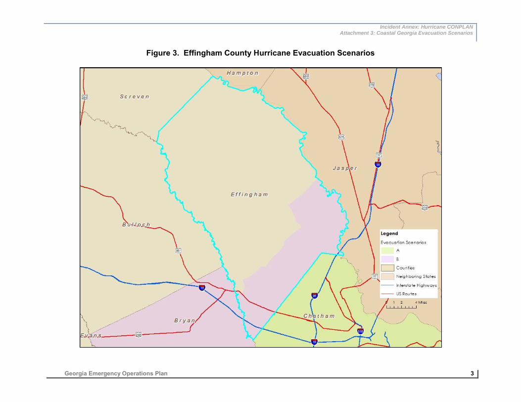
Incident Annex: Hurricane CONPLAN Attachment 3: Coastal Georgia Evacuation Scenarios
Georgia Emergency Operations Plan 3
Figure 3. Effingham County Hurricane Evacuation Scenarios
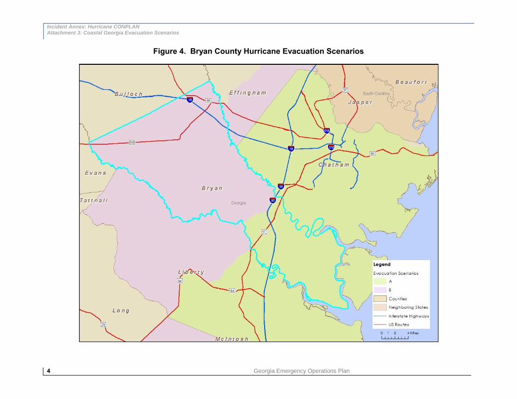
Incident Annex: Hurricane CONPLAN Attachment 3: Coastal Georgia Evacuation Scenarios
4 Georgia Emergency Operations Plan
Figure 4. Bryan County Hurricane Evacuation Scenarios

Incident Annex: Hurricane CONPLAN Attachment 3: Coastal Georgia Evacuation Scenarios
Georgia Emergency Operations Plan 5
Figure 5. Liberty County Hurricane Evacuation Scenarios

Incident Annex: Hurricane CONPLAN Attachment 3: Coastal Georgia Evacuation Scenarios
6 Georgia Emergency Operations Plan
Figure 6. McIntosh County Hurricane Evacuation Scenarios

Incident Annex: Hurricane CONPLAN Attachment 3: Coastal Georgia Evacuation Scenarios
Georgia Emergency Operations Plan 7
Figure 7. Long County Hurricane Evacuation Scenarios

Incident Annex: Hurricane CONPLAN Attachment 3: Coastal Georgia Evacuation Scenarios
8 Georgia Emergency Operations Plan
Figure 8. Glynn County Hurricane Evacuation Scenarios

Incident Annex: Hurricane CONPLAN Attachment 3: Coastal Georgia Evacuation Scenarios
Georgia Emergency Operations Plan 9
Figure 9. Wayne County Hurricane Evacuation Scenarios

Incident Annex: Hurricane CONPLAN Attachment 3: Coastal Georgia Evacuation Scenarios
10 Georgia Emergency Operations Plan
Figure 10. Camden County Hurricane Evacuation Scenarios

Incident Annex: Hurricane CONPLAN Attachment 3: Coastal Georgia Evacuation Scenarios
Georgia Emergency Operations Plan 11
Figure 11. Brantley County Hurricane Evacuation Scenarios

Incident Annex: Hurricane CONPLAN Attachment 2: The Saffir-Simpson Hurricane Wind Scale
12 Georgia Emergency Operations Plan
Figure 12. Charlton County Hurricane Evacuation Scenarios
Incident Annex: Hurricane CONPLAN Appendix 1: State Operating Conditions (OPCONs)
Georgia Emergency Operations Plan 1
Incident Annex: Hurricane CONPLAN Appendix 1: State Operating Conditions (OPCONs)
INTRODUCTION
The goal of the Incident Annex A: Hurricane CONPLAN (“Hurricane Plan”) is to provide
policies and procedures to facilitate efficient and effective preparedness and initial
response activities with regards to tropical cyclone-related hazards that threaten Georgia
annually. This Hurricane Plan Appendix establishes State Operating Conditions
(OPCONs), a time-delineated, action-oriented preparedness and response framework.
The OPCONs present a brief summary of the major incident objectives and actions that
will be taken by the State to prepare for and respond to a tropical cyclone that threatens
Georgia or another state within the Southeast U.S. This list of time-delineated actions is
not intended to be comprehensive or exhaustive; rather, it is intended to provide an
overview of the most important and mission-critical actions being undertaken or enacted.
The OPCON structure’s timeline references the arrival of tropical storm force winds (34
knots / 39 mph) as the time by which essential preparedness activities must be
complete.
As defined by the National Hurricane Center, the hurricane season in the Atlantic Ocean
begins June 1 and ends on November 30.
STATE OPERATING CONDIT IONS
The OPCONs progress through a variety of periods with regard to hurricane threat, from
day-to-day monitoring and preparedness efforts (OPCON 5) through direct and/or
indirect impacts anticipated for Georgia (OPCON 1) where state-level assistance is
required for coordination and support.
OPCON 5 – Normal Operat ions and At lant i c Basin Moni to r ing OPCON 5 represents the normal day-to-day operating level of the Georgia
Emergency Management Agency’s (GEMA/HS) State Operations Center (SOC) during
any time of the year when Georgia is not threatened by a tropical cyclone.
GEMA/HS SOC typically operates at OPCON 5 outside of hurricane season.
Activities during OPCON 5 include reviewing and updating operations plans;
developing Standard Operating Procedures (SOPs) for hurricane response;
providing training; conducting exercises; facilitating

Incident Annex: Hurricane CONPLAN Appendix 1: State Operating Conditions (OPCONs)
2 Georgia Emergency Operations Plan
public outreach and education; reviewing impacts from previous hurricane seasons; and
incorporating lessons learned and best practices into operational procedures.
During hurricane season, OPCON 5 represents the monitoring phase. The Atlantic
Basin is regularly and vigilantly monitored to determine the existence, status, and/or
threat level of tropical systems that may pose a threat to Georgia. When a tropical
cyclone poses a threat to any Gulf or Atlantic coast state, coordination efforts are
initiated. A list of the typical actions to support OPCON 5 by position title and relevant
Emergency Support Function (ESF) follows.
Director of the SOC
Ensure operations readiness by conducting periodic tests of the SOC
equipment and facilities.
Conduct regular training for disaster operations staff.
Periodically verify contact information for Primary and Alternate Emergency Coordinators.
Participate in coordination conference calls with disaster response enterprise partners.
Planning Section Director and Hurricane Program Manager
Review after-action reports from previous hurricane seasons and extract
lessons learned and best practices to update the Hurricane Plan as needed.
Conduct statewide hurricane readiness training for disaster operations personnel.
During hurricane season, monitor National Hurricane Center (NHC) forecast products to stay informed of the development and progress of tropical cyclones.
Produce Situation Awareness Statements to alert emergency management personnel of any significant and potentially threatening tropical cyclones.
Participate in coordination conference calls with disaster response enterprise partners.
ESF-15 External Affairs
Utilize the Ready Georgia campaign and develop other public awareness
materials to inform the public of the threat of tropical cyclones.

Incident Annex: Hurricane CONPLAN Appendix 1: State Operating Conditions (OPCONs)
Georgia Emergency Operations Plan 3
Promote awareness of tropical cyclones and severe weather through
participation in the National Hurricane Awareness Week and the Georgia
Severe Weather Awareness Week.
Issue press releases as appropriate regarding tropical cyclone threats.
Participate in coordination conference calls with disaster response enterprise
partners.
OPCON 4 – Po tent i a l Impacts Wi th in 120 Hours OPCON 4 is initiated upon the initial threat of a tropical cyclone to Georgia or the
Southeast U.S. The initial threat is qualified by the possible impact of tropical cyclone-
related hazards within five days (120 hours). This is represented graphically by the NHC
forecast track error cone. Direct impacts anticipated from a tropical cyclone include
storm surge, winds, tornadoes, and torrential raining that may lead to inland flooding.
Though the most substantial threat would be to coastal Georgia, a tropical cyclone could
potentially impact the entire state depending on the storm’s size, intensity, and forward
speed.
A tropical cyclone threat to other states in the Southeast U.S. would also necessitate the
transition to OPCON 4. Indirect impacts would be anticipated for Georgia, such as the
potential influx of evacuees from the threatened state.
Operations during OPCON 4 typically include a partial activation of the SOC;
dissemination of threat information to key disaster partners; regional conference calls
with threatened areas and/or neighboring states as applicable; and the coordination of
preparedness efforts with FEMA, NHC, NWS, local EMAs, and other state EMAs. A list
of the typical actions to support OPCON 4 by position title and relevant ESF follows.
GEMA/HS Director / GEMA Command Staff
Initiate partial activation of the SOC (SOC Level 2) to include
GEMA/HS command staff and relevant ESFs.
Oversee the assemblage and provision of Management Reports to the Office
of the Governor.
Draft an Executive Order for the declaration of a Governor’s State of
Emergency and potentially a Pre-Landfall Presidential Emergency
Declaration.
Participate in coordination conference calls with disaster response enterprise
partners.

Incident Annex: Hurricane CONPLAN Appendix 1: State Operating Conditions (OPCONs)
4 Georgia Emergency Operations Plan
Begin coordination efforts with FEMA.
Incident Commander / Unified Command
Determine and prioritize incident objectives.
Ensure initiation of staff briefings including command staff, section chiefs, and
general staff.
Continue to evaluate the incident situation to determine appropriate staffing
levels and additional ESFs needed to support mission critical needs.
Approve the Incident Action Plan (IAP) for future operational periods.
Participate in coordination conference calls with disaster response enterprise
partners.
Planning Section Chief
Facilitate general staff briefings.
Initiate Incident Action Plan development for future operational periods.
Maintain situational awareness and gather intelligence for the creation of
Situation Reports.
Facilitate joint planning meetings.
Facilitate coordination conference calls with disaster response enterprise
partners.
Operations Section Chief
Place GEMA/HS Field Staff on alert for possible disasters operations.
Place Evacuation and Re-entry Branch (ERB) staff on alert and request
initiation of ERB site preparation.
Participate in coordination conference calls with disaster response enterprise
partners.

Incident Annex: Hurricane CONPLAN Appendix 1: State Operating Conditions (OPCONs)
Georgia Emergency Operations Plan 5
Logistics Section Chief
Facilitate and document Emergency Management Assistance Compact
(EMAC) requests.
Participate in pre-planning activities for potential logistical support and
commodities missions.
Place Logistics Staging Area (LSA) site and LSA Incident Management Team
(IMT) staff on standby for potential logistics operations.
Contact forward logistics support providers and determine operational
readiness.
Finance Section Chief
Initiate resource procurement procedures.
Begin financial tracking procedures.
ESF #1 – Transportation
Determine the status of ongoing construction projects on evacuation routes,
and brief Unified Command on projected impediments to potential
evacuations.
Prepare Georgia Department of Transportation (GDOT) Highway Emergency
Response Operator (HERO) vehicles for evacuation support in anticipation of
evacuations.
Notify GDOT districts of tropical cyclone status and forecast, and possible
state-level protective actions.
Initiate planning with ESF #13 – Public Safety and Security Services to
support evacuation traffic control missions, to include the monitoring of and
assistance along evacuation routes as well as staffing for traffic control
points. Alert pre-identified staff of possible operations.
Coordinate with local EMAs to determine possible evacuation transportation
assets and resource needs, and begin procurement procedures for assets
and resources.

Incident Annex: Hurricane CONPLAN Appendix 1: State Operating Conditions (OPCONs)
6 Georgia Emergency Operations Plan
ESF #2 – Communications
Determine the availability and status of wireless communications equipment.
Conduct tests of all communications equipment and alert/notification
systems.
Ready deployable communications resources to support forward disaster
operations.
ESF #3 – Public Works and Engineering
Initiate planning activities with re-entry task force partners for potential post-
landfall debris clearing missions along access routes.
ESF #5 – Emergency Management
Coordinate with the Georgia Department of Economic Development (GDEcD)
to determine hotel and motel availability throughout the state to support
evacuee planning.
Ensure timely production and dissemination of situation reports, situation
awareness statements, and Incident Action Plans in conjunction with the
Planning Section Chief.
Participate in incident briefings from the National Hurricane Center and the
National Weather Service, and coordination conference calls with state
partners and local EMAs.
ESF #6 – Mass Care, Housing, and Human Services
Review hurricane response protocols for evacuation and sheltering
operations.
Coordinate with the American Red Cross (ARC) and Department of Human
Services (DHS) Division of Family and Child Services (DFCS) to prepare for
possible sheltering operations.
Post updated shelter database on the GEMA/HS website.
Coordinate with ESF #11 – Agricultural and Natural Resources on the
identification and availability of bulk food resources to support potential
sheltering and mass feeding missions.

Incident Annex: Hurricane CONPLAN Appendix 1: State Operating Conditions (OPCONs)
Georgia Emergency Operations Plan 7
ESF #7 – Logistics Management and Resource Support
Place LSA site and support staff on standby for potential logistics operations.
Coordinate with local EMAs on potential Point of Distribution (POD) site
locations for potential commodity distribution operations.
Contact non-governmental logistics providers to determine readiness level
and place them of alert for potential operations within 120 hours.
Initiate planning with FEMA on potential Initial Response Resources (IRR)
that may be delivered to the LSA pending an elevated threat level.
Coordinate with ESF #1 – Transportation and ESF #13 – Public Safety and
Security Services for transportation resources and security escorts supporting
commodity transport missions.
ESF #8 – Public Health and Medical Services
Coordinate with the DFCS to ensure personnel are prepared for possible
special needs sheltering operations.
ESF #9 – Search, Rescue, and Recovery
Alert SRR task forces and support resources of threat level.
ESF #11 – Agricultural and Natural Resources
Initiate planning for potential animal-friendly and pet-friendly shelters, and
animal congregation areas to support evacuees.
In conjunction with ESF #6 – Mass Care, Housing, and Human Services,
identify bulk food resources to support potential mass feeding missions.
ESF #12 – Energy
Coordinate with ESF #3 – Public Works and Engineering on the identification
of electrical utility resources to support potential road clearing missions during
re-entry.
In conjunction with ESF #7 – Logistics Management and Resource Support,
identify bulk fuel resources to support mass evacuations and post-landfall
disaster response operations.

Incident Annex: Hurricane CONPLAN Appendix 1: State Operating Conditions (OPCONs)
8 Georgia Emergency Operations Plan
ESF# 13 – Public Safety and Security Services
Initiate planning for security support for logistical transport missions,
evacuation route monitoring (both ground-based and aviation-based)
missions.
Coordinate with local EMAs on potential needs for law enforcement support
at traffic control points during evacuations.
Initiate planning to support check-point staffing missions during post-landfall
operations for areas that may require controlled access.
Initiate planning on possible post-landfall security operations within impacted
areas.
ESF#15 – External Affairs
Prepare and distribute press releases concerning ongoing preparedness and
response actions.
Request state and local media disseminate information about family
preparedness for tropical cyclones.
Notify additional external affairs personnel of potential need for assistance.
Pending threat and scope of preparedness actions, initiate a Joint Information
Center (JIC) to coordinate disaster information.
Respond to media requests and provide information / updates as needed.
Conduct media briefings from the SOC as needed.
OPCON 3 – Po tent i a l Impacts Wi th in 72 Hours OPCON 3 represents a significant threat elevation from a tropical cyclone. A threat is
considered significant when tropical cyclone-related hazards – the initial hazard being
tropical storm force winds (34 knots or 39 mph) – are forecast to affect Georgia within 72
hours. OPCON 3 is also initiated for the anticipation of indirect impacts on Georgia, such
as the coordination of federally-assisted evacuees from another threatened state.
During OPCON 3, for a direct threat to Georgia, the GEMA/HS SOC will be fully
activated (SOC Level 1) with all relevant ESFs to adequately prepare for the elevated
threat. A list of the typical actions to support OPCON 3 by position title and relevant ESF
follows.

Incident Annex: Hurricane CONPLAN Appendix 1: State Operating Conditions (OPCONs)
Georgia Emergency Operations Plan 9
GEMA/HS Director / GEMA/HS Command Staff
Assess the need to submit an Executive Order for the declaration of a
Governor’s State of Emergency, and make recommendations accordingly.
Assess the need to request a Pre-Landfall Presidential Emergency
Declaration. If determined, provide appropriate information to the Governor’s
Office.
Oversee the assemblage and provision of management reports to the Office
of the Governor.
Initiate full activation of the GEMA/HS SOC (SOC Level 1) to include relevant
ESFs, FEMA Federal Coordinating Officer (FCO), FEMA Liaison Officer(s)
(LNO), and other FEMA coordination teams as necessary.
Participate in coordination conference calls with disaster response enterprise
partners.
Initiate coordination and drafting of Pre-Disaster Declaration, when threat
meets requisite criteria / FEMA guidance.
Incident Commander / Unified Command
Determine and prioritize incident objectives.
Ensure continuation of staff briefings to include command staff, section
chiefs, and general staff.
Continue to evaluate the incident situation to determine appropriate staffing
levels and additional ESFs needed to support mission critical needs.
Approve IAPs for future operational periods.
Participate in coordination conference calls with disaster response enterprise
partners.
Planning Section Chief
Facilitate general staff briefings.
Oversee development of the IAP.

Incident Annex: Hurricane CONPLAN Appendix 1: State Operating Conditions (OPCONs)
10 Georgia Emergency Operations Plan
Maintain situational awareness and gather intelligence for the creation of
Situation Reports.
Facilitate joint planning meetings.
Facilitate coordination conference calls with disaster response enterprise
partners.
Operations Section Chief
Place GEMA/HS Field Staff on standby for deployment to support possible
field disasters operations.
Place ERB staff on standby for deployment, and request that ERB site
preparations be finalized.
Place Aviation Support Operations Center (ASOC) personnel on alert, and
request the initiation of site preparations.
Request the initiation of the Evacuation Liaison Team (ELT).
Place re-entry task forces on alert to potentially support forward disaster
operations.
Participate in coordination conference calls with disaster response enterprise
partners.
Logistics Section Chief
Participate in planning activities for potential logistical support and
commodities missions.
Initiate activation of the LSA and deployment of IMT.
Initiate planning for logistical support requirements for post-landfall FSA(s),
Base(s), and/or Camp(s) with state partners and logistics providers.
Participate in coordination conference calls with disaster response enterprise
partners.
Finance Section Chief
Continue resource procurement procedures.

Incident Annex: Hurricane CONPLAN Appendix 1: State Operating Conditions (OPCONs)
Georgia Emergency Operations Plan 11
Continue financial tracking procedures.
ESF #1 – Transportation
Request that GDOT cease all construction projects on evacuation routes and
provide status updates to Unified Command.
Coordinate with GDOT on the deployment of HERO vehicles and teams to
monitor I-16 and I-95 (for an Atlantic coast threat) or I-75 (for a Gulf coast
threat).
Coordinate with ESF #13 – Public Safety and Security Services to ensure
personnel are placed on standby to support evacuation traffic control
missions – both along evacuation routes and at traffic control points.
Continue to refine evacuation transport resource needs with local EMAs.
Determine the need for lane reversal (contraflow) along major evacuation
routes.
Monitor traffic counters to determine the impacts of increase in traffic volume
from evacuee movement.
Participate in ELT coordination calls.
ESF #2 – Communications
Initiate coordination and planning efforts with private-sector communications
providers.
Coordinate with ESF #7 – Logistics Management and Resource Support on
forward operations communications needs at the LSA, FSA(s), and other
forward operations centers.
ESF #3 – Public Works and Engineering
Continue planning activities with re-entry task force partners for potential
post-landfall access route debris clearing missions.
Coordinate with ESF #7 – Logistics Management and Resource Support on
potential logistical support requirements for re-entry task forces.

Incident Annex: Hurricane CONPLAN Appendix 1: State Operating Conditions (OPCONs)
12 Georgia Emergency Operations Plan
ESF #5 – Emergency Management
Request that threatened counties provide information on special events and
estimated tourist occupancy.
Coordinate with GDEcD to determine hotel/motel availability throughout
the state; publicize the information on the GEMA/HS website.
Ensure timely production and dissemination of situation reports, situation
awareness statements, and Incident Action Plans in conjunction with
Planning Section Chief.
Participate in incident briefings from the National Hurricane Center and the
National Weather Service and coordination conference calls with state
partners and local EMAs.
ESF #6 – Mass Care, Housing, and Human Services
Coordinate with the American Red Cross (ARC) and Department of Human
Services (DHR) Division of Family and Child Services (DFCS) to finalize
preparations for possible sheltering operations. Request that shelter staff be
placed on standby.
Post an updated shelter database on the GEMA/HS website.
Coordinate with ESF #11 – Agricultural and Natural Resources on the
procurement of bulk food resources to support potential sheltering and mass
feeding missions.
Participate in ELT coordination calls for the possible influx of evacuees from
threatened states.
ESF #7 – Logistics Management and Resource Support
Coordinate with local EMAs to determine the locations of Points of
Distribution (PODs) for potential commodity distribution operations.
Finalize critical commodity requirements (Initial Response Resources, or IRR)
with FEMA that may be delivered to the LSA.
Coordinate with ESF #1 – Transportation and ESF #13 – Public Safety and
Security Services on potential commodity transport missions.

Incident Annex: Hurricane CONPLAN Appendix 1: State Operating Conditions (OPCONs)
Georgia Emergency Operations Plan 13
Coordinate with ESF #12 – Energy on the identification and procurement of
bulk fuel resources to support forward disaster operations.
Facilitate and document EMAC requests.
ESF #8 – Public Health and Medical Services
Place staff on standby for possible support of special needs shelters.
Initiate planning to support potential medical evacuations.
Initiate planning for potential hospital evacuations.
ESF #9 – Search, Rescue, and Recovery
Place search, rescue, and recovery (SRR) task forces on alert for deployment
to the FSA(s) to support post-landfall operations.
ESF #11 – Agricultural and Natural Resources
Initiate planning for potential animal-friendly and pet-friendly shelters, and
animal congregation areas to support evacuees.
In conjunction with ESF #6 – Mass Care, Housing, and Human Services,
identify and procure bulk food resources to support potential mass feeding
missions.
ESF #12 – Energy
Coordinate with ESF #3 – Public Works and Engineering on the identification
of electrical utility resources to support potential road clearing missions during
re-entry.
In conjunction with ESF #7 – Logistics Management and Resource Support,
identify and procure bulk fuel resources to support forward disaster
operations.
Identify bulk fuel transportation and delivery resources to support forward
disaster operations.
Initiate coordination efforts with the Georgia Retailers Association, Georgia
Association of Convenience Stores, Georgia Petroleum Council, and other

Incident Annex: Hurricane CONPLAN Appendix 1: State Operating Conditions (OPCONs)
14 Georgia Emergency Operations Plan
relevant organizations on potential fuel shortages on evacuation routes from
anticipated evacuations.
ESF #13 – Public Safety and Security Services
Request that law enforcement personnel be placed on standby for evacuation
traffic operations, traffic control points, re-entry support, commodity transport
security, limited access area check points, and curfew enforcement in
impacted areas.
Request that aviation resources are placed on standby for reconnaissance
and damage assessment missions.
ESF#15 – External Affairs
Prepare and distribute press releases concerning ongoing preparedness and
response actions.
Request state and local media disseminate information about family
preparedness for tropical cyclones.
Notify additional external affairs personnel of potential need for assistance.
Continue to coordinate media information, press releases, and pertinent
disaster information with the JIC.
Respond to media requests and provide information / updates as needed.
Conduct media briefings from the SOC as needed.
OPCON 2 – Po tent i a l Impacts Wi th in 48 Hours OPCON 2 represents an operational level where multilateral and broad-reaching
protective actions are initiated. During this timeframe, actions supporting evacuations
(both interstate and intrastate) and preparatory actions in anticipation of direct impacts
are undertaken.
During OPCON 2, the GEMA/HS SOC is likely to be fully activated (SOC Level 1) with
all relevant ESFs to adequately prepare for the elevated threat. A list of the typical
actions to support OPCON 2 by position title and relevant ESF follows.

Incident Annex: Hurricane CONPLAN Appendix 1: State Operating Conditions (OPCONs)
Georgia Emergency Operations Plan 15
GEMA/HS Director / GEMA/HS Command Staff
Assuming a Governor’s State of Emergency has been enacted, liaise with the
Georgia Department of Defense (DOD) and ensure requisite integration of
DOD response capabilities into the State response effort.
Oversee the assemblage and provision of management reports for the Office
of the Governor.
Participate in coordination conference calls with disaster response enterprise
partners.
Ensure coordination of protective actions between the SOC and the FEMA
Regional Response Coordination Center (RRCC) and with federal LNOs.
Coordinate disaster response actions with all threatened State’s emergency
management agencies executive staff.
Facilitate media briefings.
Incident Commander / Unified Command
Determine and prioritize incident objectives.
Ensure continuation of staff briefings including command staff, section chiefs,
and general staff.
Continue to evaluate the incident situation to determine appropriate staffing
levels and additional ESFs needed to support mission critical needs.
Approve IAPs for future operational periods.
Planning Section Chief
Facilitate general staff briefings.
Oversee IAP development.
Maintain situational awareness and gather intelligence for the creation of
Situation Reports.
Facilitate joint planning meetings.
Facilitate coordination conference calls with disaster response enterprise
partners.

Incident Annex: Hurricane CONPLAN Appendix 1: State Operating Conditions (OPCONs)
16 Georgia Emergency Operations Plan
Develop and sustain a common operating picture by integrating Geographic
Information System (GIS) / mapping specialist’s capabilities with information
analysis and sharing duties.
Operations Section Chief
Deploy GEMA/HS Field Staff to support possible field disasters operations.
Deploy ERB staff and initiate evacuation support operations.
Place Aviation Support Operations Center (ASOC) personnel on standby for
deployment to support forward disaster operations and finalize site(s)
preparations.
Place re-entry task forces on standby for deployment to FSA(s) to support
forward disaster operations.
Participate in coordination conference calls with disaster response enterprise
partners.
Logistics Section Chief
Participate in planning activities for potential logistical support and
commodities missions.
In conjunction with FEMA Logistics, determine quantity and scope of critical
commodity requirements (IRR) that will be staged at the LSA.
Coordinate the activation of the FSA(s) for additional staging requirements.
Coordinate with the ERB on FSA location(s) and requirements for staging or
re-entry task forces.
Continue planning for logistical support requirements for post-landfall FSA(s)
/ Base(s) / Camp(s) with state partners and logistics providers.
Participate in coordination conference calls with disaster response enterprise
partners.
Finance Section Chief
Continue resource procurement procedures.
Continue financial tracking procedures.

Incident Annex: Hurricane CONPLAN Appendix 1: State Operating Conditions (OPCONs)
Georgia Emergency Operations Plan 17
ESF #1 – Transportation
Deploy HERO vehicles and teams to assist distressed evacuees.
In conjunction with ESF #13 – Public Safety and Security Services, deploy
personnel to support evacuation traffic control missions – both along
evacuation routes and at traffic control points.
Procure and provide evacuation transportation resources to support local
evacuations.
If necessary, implement lane reversal (contraflow) on major evacuation
routes.
Monitor traffic counters to determine traffic flow increases from evacuees.
Participate in ELT coordination calls.
In conjunction with the ERB, identify, assess, and respond to evacuation-
related issues.
Coordinate needs for aerial reconnaissance for evacuation route monitoring.
ESF #2 – Communications
Continue coordination and planning efforts with private-sector
communications providers.
Coordinate with ESF #7 – Logistics Management and Resource Support on
forward operations communications needs at the LSA, FSA(s), and other
forward operations centers.
ESF #3 – Public Works and Engineering
Continue planning activities with re-entry task force partners for potential
post-landfall access route debris clearing missions.
Place re-entry task forces on standby for deployment to support disaster
operations.
Coordinate with ESF #7 – Logistics Management and Resource Support on
logistical support requirements for re-entry task forces at FSA(s).

Incident Annex: Hurricane CONPLAN Appendix 1: State Operating Conditions (OPCONs)
18 Georgia Emergency Operations Plan
ESF #5 – Emergency Management
Coordinate with GDEcD to determine hotel/motel availability throughout
the state and publicize the information on the GEMA/HS website.
Ensure timely production and dissemination of situation reports, situation
awareness statements, and Incident Action Plans in conjunction with
Planning Section Chief.
Participate in incident briefings from the National Hurricane Center and the
National Weather Service and coordination conference calls with state
partners and local EMAs.
Initiate planning with FEMA to determine potential locations for a Joint Field
Office (JFO).
ESF #6 – Mass Care, Housing, and Human Services
Finalize shelter preparations and coordinate their opening where necessary.
Post updated shelter database on the GEMA/HS website.
Coordinate with ESF #11 – Agricultural and Natural Resources on the
procurement of bulk food resources to support sheltering and mass feeding
missions.
Participate in ELT coordination calls to respond to the influx of evacuees from
threatened states.
ESF #7 – Logistics Management and Resource Support
Coordinate with local EMAs to determine the locations of Points of
Distribution (POD) for commodity distribution operations and determine site
logistical support requirements.
Receive and stage at the LSA critical commodity shipments (IRR) from
FEMA.
Coordinate with ESF #1 – Transportation and ESF #13 – Public Safety and
Security Services on potential commodity transport missions.
Coordinate with ESF #12 – Energy on the identification and procurement of
bulk fuel resources to support forward disaster operations.

Incident Annex: Hurricane CONPLAN Appendix 1: State Operating Conditions (OPCONs)
Georgia Emergency Operations Plan 19
Facilitate and document EMAC requests.
ESF #8 – Public Health and Medical Services
Finalize special needs shelter preparations and coordinate and support their
opening where necessary.
Coordinate and support medical evacuations.
Coordinate hospital evacuations.
Coordinate with ESF #11 – Agricultural and Natural Resources on the
procurement of bulk food resources to support special needs sheltering.
Initiate planning with ESF #9 – Search, Rescue, and Recovery to support
post-landfall medical evacuations.
ESF #9 – Search, Rescue, and Recovery
Place SRR task forces on standby for deployment to the FSA(s) to support
post-landfall operations.
Coordinate with ESF #7 – Logistics Management and Resource Support for
SRR task force logistical support requirements.
Coordinate aviation resource staging with ASOC.
ESF #11 – Agricultural and Natural Resources
Initiate and support animal-friendly and pet-friendly shelters, and animal
congregation areas.
In conjunction with ESF #6 – Mass Care, Housing, and Human Services,
procure and coordinate distribution of bulk food resources to support
sheltering and mass feeding missions.
Initiate planning for the administration of the Disaster Food Stamp Program.
Initiate planning with ESF #9 – Search, Rescue, and Recovery on potential
animal rescue operations during post-landfall SRR missions.

Incident Annex: Hurricane CONPLAN Appendix 1: State Operating Conditions (OPCONs)
20 Georgia Emergency Operations Plan
ESF #12 – Energy
Coordinate with ESF #3 – Public Works and Engineering on the identification
of electrical utility resources to support potential road clearing missions during
re-entry.
In conjunction with ESF #7 – Logistics Management and Resource Support,
identify and procure bulk fuel resources to support disaster operations.
Initiate state fuel storage tank filling to and topping off to support disaster
operations.
Procure and stage bulk fuel transportation and delivery resources to support
disaster operations.
Initiate coordination efforts with the Georgia Retailers Association and other
relevant organizations on potential fuel shortages on evacuation routes from
anticipated and ongoing evacuations.
ESF #13 – Public Safety and Security Services
Deploy law enforcement personnel to support evacuation traffic operations,
traffic control points, and lane reversal (contraflow) operations if enacted.
Place law enforcement personnel on standby for post-landfall re-entry
support, commodity transport security, limited access areas check points, and
curfew enforcement in impacted areas.
Deploy aviation resources for reconnaissance and evacuation route
monitoring.
ESF#15 – External Affairs
Prepare and distribute press releases concerning ongoing preparedness and
response actions.
Coordinate with Georgia Public Broadcasting (GPB) and media partners on
evacuation and sheltering information dissemination.
Continue to coordinate media information, press releases, and pertinent
disaster information with the JIC.
Respond to media requests and provide information / updates as needed.
Incident Annex: Hurricane CONPLAN Appendix 1: State Operating Conditions (OPCONs)
Georgia Emergency Operations Plan 21
Conduct media briefings from the SOC upon request.
OPCON 1 – Po tent i a l Imp acts Wi th in 24 Hours OPCON 1 represents the most elevated level of operational preparedness and
response. It is the action phase where all protective actions in preparation of direct
impacts from tropical cyclone-related hazards are finalized and all actions for
coordinating indirect impact-related protective actions are undertaken.
During OPCON 1, the GEMA/HS/HS/HS/HS SOC will remain fully activated (SOC Level
1) with all relevant ESFs to adequately prepare for the imminent threat. A list of the
typical actions to support OPCON 1 by position title and relevant ESF follows.
GEMA/HS/HS/HS/HS Director / GEMA/HS/HS/HS Command Staff
Oversee the assemblage and provision of management reports for the Office
of the Governor.
Participate in coordination conference calls with disaster response enterprise
partners.
Ensure coordination of protective actions between the SOC and the FEMA
Regional RRCC and with federal LNOs.
Coordinate disaster response actions with all threatened State’s emergency
management agencies executive staff.
Facilitate media briefings.
Incident Commander / Unified Command
Determine and prioritize incident objectives.
Ensure continuation of staff briefings including command staff, section chiefs,
and general staff.
Continue to evaluate the incident situation to determine appropriate staffing
levels and additional ESFs needed to support mission critical needs.
Approve IAPs for future operational periods.

Incident Annex: Hurricane CONPLAN Appendix 1: State Operating Conditions (OPCONs)
22 Georgia Emergency Operations Plan
Planning Section Chief
Facilitate general staff briefings.
Oversee IAP development.
Maintain situational awareness and gather intelligence for the creation of
Situation Reports.
Facilitate joint planning meetings.
Facilitate coordination conference calls with disaster response enterprise
partners.
Continue to provide a common operating picture by integrating Geographic
Information System (GIS) / mapping specialist’s capabilities with information
analysis and sharing duties.
In conjunction with Operations Section Chief, Logistics Chief, and ERB,
continue re-entry planning.
Operations Section Chief
Coordinate with GEMA/HS Field Staff to identify and facilitate additionally
needed protective actions and to finalize forward preparatory actions.
Support ERB operations through fulfillment of evacuations-related requests
for assistance.
Deploy ASOC personnel and initiate operations.
In conjunction with the ERB, deploy re-entry task forces to FSA(s) to support
post-landfall disaster operations.
In conjunction with the ERB, coordinate the cessation of evacuation
operations including the abatement of contraflow.
Participate in coordination conference calls with disaster response enterprise
partners.
Logistics Section Chief
Participate in planning activities for logistical support and commodities
missions.
Incident Annex: Hurricane CONPLAN Appendix 1: State Operating Conditions (OPCONs)
Georgia Emergency Operations Plan 23
In conjunction with FEMA Logistics, coordinate the reception of critical
commodity requirements (IRR) that will be staged at the LSA.
Provide requisite logistical support for the FSA(s).
Coordinate logistical support for post-landfall FSA(s) / Base(s) / Camp(s) with
state partners and logistics providers.
Participate in coordination conference calls with disaster response enterprise
partners.
Finance Section Chief
Continue resource procurement procedures.
Continue financial tracking procedures.
ESF #1 – Transportation
Coordinate the cessation of evacuation operations including the abatement of
contraflow.
Retract HERO vehicles and forward deployed evacuation support resources.
Monitor traffic counters to determine traffic flow / evacuation status.
Participate in ELT coordination calls.
In conjunction with ESF #13 – Public Safety and Security Services, initiate
planning for aerial reconnaissance for post-landfall re-entry route status.
In conjunction with ASOC, stage aviation resources at the FSA(s) for post-
landfall operations.
In conjunction with ESF#3 – Public Works and Engineering, initiate re-entry
planning.
ESF #2 – Communications
Continue coordination and planning efforts with private-sector
communications providers.

Incident Annex: Hurricane CONPLAN Appendix 1: State Operating Conditions (OPCONs)
24 Georgia Emergency Operations Plan
Coordinate with ESF #7 – Logistics Management and Resource Support on
forward operations communications needs at the LSA, FSA(s), and other
forward operations centers.
In conjunction with ESF#3 – Public Works and Engineering, initiate planning
for post-landfall communications needs for forward deployed response teams
and forward operations centers.
In conjunction with ESF #7 – Logistics Management and Resource Support,
coordinate the deployment of communications resources to the FSA(s).
ESF #3 – Public Works and Engineering
Continue planning activities with re-entry task force partners for potential
post-landfall access route debris clearing missions.
Deploy re-entry task forces to the FSA(s).
Coordinate with ESF #7 – Logistics Management and Resource Support on
logistical support requirements for re-entry task forces at the FSA(s).
ESF #4 – Fire Fighting and Life Safety
Initiate planning for post-landfall fire suppression support requirements with
the Georgia Mutual Aid Group (GMAG) and local fire service providers.
ESF #5 – Emergency Management
Coordinate with GDEcD to determine hotel/motel availability throughout
the state and publicize the information on the GEMA/HS website.
Ensure timely production and dissemination of situation reports, situation
awareness statements, and Incident Action Plans in conjunction with
Planning Section Chief.
Participate in incident briefings from the National Hurricane Center and the
National Weather Service and coordination conference calls with state
partners and local EMAs.
Finalize planning efforts with FEMA to determine potential locations for a
Joint Field Office (JFO).

Incident Annex: Hurricane CONPLAN Appendix 1: State Operating Conditions (OPCONs)
Georgia Emergency Operations Plan 25
ESF#6 – Mass Care, Housing, and Human Services
Continue to coordinate and support ongoing sheltering operations.
Post updated shelter database on the GEMA/HS website.
Continue to coordinate with ESF #11 – Agricultural and Natural Resources on
the procurement of bulk food resources to support sheltering and mass
feeding missions.
Participate in ELT coordination calls to respond to the influx of evacuees from
threatened states.
ESF #7 – Logistics Management and Resource Support
Continue to coordinate with local EMAs to determine the locations of Points
of Distribution (POD) for commodity distribution operations and determine site
logistical support requirements.
Receive and stage at the LSA critical commodity shipments (IRR) from
FEMA.
Continue to coordinate with ESF #1 – Transportation and ESF #13 – Public
Safety and Security Services on potential commodity transport missions.
Continue to coordinate with ESF #12 – Energy on the identification and
procurement of bulk fuel resources to support forward disaster operations.
Facilitate and document EMAC requests.
ESF #8 – Public Health and Medical Services
Coordinate and support special needs shelter operations.
Coordinate and support medical evacuations.
Coordinate hospital evacuations.
Coordinate with ESF #11 – Agricultural and Natural Resources on the
procurement of bulk food resources to support special needs sheltering.
Continue planning with ESF #9 – Search, Rescue, and Recovery to support
post-landfall medical evacuations.

Incident Annex: Hurricane CONPLAN Appendix 1: State Operating Conditions (OPCONs)
26 Georgia Emergency Operations Plan
ESF #9 – Search, Rescue, and Recovery
Initiate staging of SRR task forces for post-landfall operations.
Coordinate with ESF #7 – Logistics Management and Resource Support for
SRR task force logistical support requirements.
Coordinate aviation resource staging with ASOC.
ESF #10 – Hazardous Materials
Initiate planning for post-landfall hazardous materials response operations.
ESF #11 – Agricultural and Natural Resources
Continue to support animal-friendly and pet-friendly shelters, and animal
congregation areas.
In conjunction with ESF #6 – Mass Care, Housing, and Human Services,
procure and coordinate distribution of bulk food resources to support
sheltering and mass feeding missions.
Finalize preparations for the administration of the Disaster Food Stamp
Program.
Finalize planning with ESF #9 – Search, Rescue, and Recovery on potential
animal rescue operations during post-landfall SRR missions.
ESF #12 – Energy
Continue to coordinate with ESF #3 – Public Works and Engineering on the
identification of electrical utility resources to support post-landfall road
clearing missions during re-entry operations.
In conjunction with ESF #7 – Logistics Management and Resource Support,
identify and procure bulk fuel resources to support disaster operations.
Finalize state fuel storage tank filling to and topping off to support disaster
operations.
Finalize the procurement and staging bulk fuel transportation and delivery
resources to support disaster operations.
Incident Annex: Hurricane CONPLAN Appendix 1: State Operating Conditions (OPCONs)
Georgia Emergency Operations Plan 27
ESF #13 – Public Safety and Security Services
Retract law enforcement personnel supporting evacuation traffic operations,
traffic control points, and lane reversal (contraflow) operations.
Place law enforcement personnel on standby for post-landfall re-entry
support, commodity transport security, limited access areas check points, and
curfew enforcement in impacted areas.
Finalize post-landfall aviation resource preparations and stage aviation
resources for reconnaissance and damage assessment missions. Coordinate
aviation asset staging with ASOC.
ESF #14 – Long Term Recovery
In conjunction with FEMA, initiate post-landfall recovery planning.
Place Individual Assistance (IA) and Public Assistance (PA) program staff on
standby for post-landfall operations within the JFO.
In conjunction with FEMA, initiate planning for post-landfall joint preliminary
damage assessments.
ESF#15 – External Affairs
Prepare and distribute press releases concerning ongoing preparedness and
response actions.
Coordinate with Georgia Public Broadcasting (GPB) and media partners on
evacuation and sheltering information dissemination.
Continue to coordinate media information, press releases, and pertinent
disaster information with the JIC.
Respond to media requests and provide information / updates as needed.
Conduct media briefings from the SOC upon request.

Incident Annex: Hurricane CONPLAN Appendix 2: Evacuations
1 Georgia Emergency Operations Plan
Incident Annex: Hurricane CONPLAN Appendix 2: Hurricane Evacuations
INTRODUCTION
Tropical cyclones pose a very real and significant threat to Georgia. The Georgia coast is one of
the most vulnerable areas to storm surge in the United States, similar to that of coastal
Mississippi, which experienced catastrophic flooding during Hurricane Katrina (2005). Coastal
areas have the potential for a storm surge exceeding 30 feet above ground which may in many
areas extend more than 25 miles inland.
Storm surge vulnerability is the primary reason for the issuance of evacuation orders. Because
of the extreme damage potential that exists with storm surge, elected officials in coastal
counties will issue out-of-county evacuations when a tropical cyclone threatens coastal areas.
Elected officials in inland counties may issue in-county evacuation orders for citizens living in
vulnerable housing such as mobile or manufactured homes in response to the threat of high
winds or for any housing that exists in flood-prone areas.
In the US, residents who live along the Gulf and East Coasts face the threat of tropical cyclones
each year. When evacuation orders are issued in neighboring states, including Florida,
Alabama, and South Carolina, evacuees often travel to Georgia. However, evacuees from more
distant locations, such as Louisiana, have fled to Georgia as well. Federally coordinated
transportation assisted citizens from distant locations may also arrive in Georgia, requiring
evacuee support.
Under certain circumstances, the threat of a major hurricane may cause millions of people to
evacuate. The most recent significant threat to Georgia by a major hurricane causing mass
evacuations was Hurricane Floyd (1999). Evacuations within Florida, Georgia, South Carolina,
and North Carolina resulted in a mass exodus of approximately three million people including
over 350,000 citizens from the Georgia coast. This mass evacuation resulted in an estimated
40,000 people seeking refuge in numerous shelters in Georgia.
AUTHORITIES
The Georgia Emergency Management Act of 1981, as amended, provides the authority to the
county commission or elected authority to order an evacuation when deemed necessary to
protect lives. Each local government is responsible for evacuating areas within its jurisdiction
and shall establish priorities and regulations regarding evacuation of residents and visitors.
Elected officials base their decisions on a variety of factors, with particular reliance upon
recommendations from the local EMA director.

Incident Annex: Hurricane CONPLAN Appendix 2: Evacuations
Georgia Emergency Operations Plan 2
In the event that evacuation requirements exceed the capabilities of the local government, the
Governor, through the Director of GEMA/HS, has the authority to assume direction and control
of the situation. However, this authority has never been exercised.
State agencies will be authorized to assist local authorities when a State of Emergency is
declared by the Governor.
COORDIN ATION
Federa l Interstate evacuation coordination is vital to the success of a comprehensive evacuation
strategy. In recognition of the fact that hurricane-related evacuations affect multiple states,
FEMA has developed the Evacuation Liaison Team (ELT), which serves t0 facilitate interstate
evacuation coordination.
The ELT is comprised of organizations that have major roles in evacuation operations, including
FEMA, the Federal Highway Administration (FHWA), State Departments of Transportation
(DOTs), and State Emergency Management Agencies (EMAs). Conference calls with the ELT
are held twice daily to ensure effective evacuation coordination with federal and state agencies.
Additional efforts are made to coordinate evacuation information across a broader audience of
organizations involved in emergency and disaster response operations. During the threat of a
tropical cyclone, FEMA hosts video-teleconference calls (VTCs) once daily to coordinate
response efforts among federal and state agencies. The VTC provides another venue for
sharing information about protective actions being taken by the states, including evacuation
coordination.
Sta te The interstate evacuation that occurred due to the threat of Hurricane Floyd (1999)
demonstrated the need for enhanced evacuation coordination capabilities at the state level. In
response, Georgia formed the Evacuation and Re-Entry Branch (ERB), a branch of the
Operations Section within the Incident/Unified Command structure. The ERB enhances
collaboration amongst state organizations involved in evacuation operations. The group is
comprised of an ERB Branch Chief – typically, a GEMA/HS Field Coordinator – and
representatives from Georgia Department of Transportation (GDOT),Georgia Department of
Defense (GaDOD), Georgia Forestry Commission (GFC),Georgia Public Service Commission
(PSC), Georgia State Patrol (GSP), Georgia Department of Natural Resources (DNR), Amateur
Radio Emergency Services (ARES), and utility companies, as well as Public Information
Officers (PIOs) from agencies and organizations as deemed appropriate. The personnel
selected are those who

Incident Annex: Hurricane CONPLAN Appendix 2: Evacuations
3 Georgia Emergency Operations Plan
regularly interface with local officials in coastal areas and therefore familiar with the challenges
of evacuation and re-entry.
When a direct threat to the state by a hurricane is identified (upwards of five days prior to
anticipated impacts and at the onset of OPCON 4),the State Operations Center (SOC) initiates
protective action coordination conference calls with local EMAs and the National Weather
Service (NWS). During these calls, local EMAs discuss anticipated requests for assistance,
including evacuation coordination. At this time, the ERB is placed on standby for potential
deployment to assist with evacuation efforts at the coast. If it determined that evacuations are
necessary, the ERB is deployed to the coast at the onset of OPCON 2. During operations, the
ERB collaborates closely with local EMAs to ensure that the state’s response is appropriate to
local needs.
Public information plays a critical role in evacuation operations. ESF #15, in coordination with
the ERB, is tasked with acquiring and disseminating information regarding evacuation and
sheltering within the state. When ESF #15 receives information, it is vetted and then distributed
to media partners via the State Joint Information Center (S-JIC).
Local County EMAs act as the primary point of contact for coordination efforts between
local organizations and GEMA/HS. Evacuation information undertaken at the local level will be
provided to GEMA/HS/HS via information communicated with the ERB. Non-evacuation
information will be coordinated with the GEMA/HS/HS SOC directly.
Local elected officials possess the authority to issue evacuation orders. During a tropical
cyclone threat to coastal Georgia, in each county, a Command Policy Group (CPG) comprised
of local elected officials and emergency management partners will confer regarding the need to
initiate evacuation plans, including which areas to evacuate and the timing of the evacuation.
The ERB will communicate the results of these decisions to the SOC.
EVACU ATION S TRATEGY
Genera l This appendix provides an overview of the operational strategies that pertain to supporting local
evacuations within Georgia or from neighboring states where self-evacuees flee to Georgia. For
information regarding federally-assisted evacuees and associated evacuee support, please
refer to the 2012 GEOP Support Annex 2S-9: Evacuation Support for a Catastrophic Event. For
information regarding the evacuation of special needs populations from coastal areas, please
refer to GEMA/HS SOP 2-1: Special Needs Coastal Evacuation Assistance.
Incident Annex: Hurricane CONPLAN Appendix 2: Evacuations
Georgia Emergency Operations Plan 4
The basis for the evacuation operation strategies reflected in this appendix is the Georgia
Hurricane Evacuation Study (HES). This study, a partnership between local, state, and federal
entities, is currently being updated. Approved deliverables from the transportation analysis
portion of the study are presented here. The HES includes details on a phased evacuation
process for the coast and provides clearance times for evacuation for each county. In addition,
the HES compiles the locations of critical roadway segments and traffic control points so that
the State may place resources appropriately to assist in the evacuation process.
Evacuat ion Zones
Evacuation zones are designed primarily to re-locate residents who face the greatest risk of
storm surge inundation from a tropical cyclone. Because the extent of inundation varies greatly
depending on characteristics of the storm, evacuation zones are spatially delineated to
evacuate only those citizens who are truly at risk.
Coastal Georgia has adopted a phased evacuation process; evacuations are phased both
spatially (partial and full county) and temporally (recommended, or voluntary, and mandatory).
Each county has designated “Scenario A” or “Scenario B” evacuation zones. Scenario A
evacuates residents most prone to storm surge inundation, which include those who live on
islands, along waterfronts, and in other flood-prone areas. These zones are used for a strong
tropical storm or a Category 1 or 2 hurricane. Scenario B evacuates residents in the “Scenario
A” zone as well as areas further inland. This scenario is utilized for evacuation for a major
hurricane of Categories 3, 4, or 5.
When a tropical cyclone is approaching, local officials will typically issue a “recommended” (as
termed in Chatham County) or “voluntary” (as termed in other counties) evacuation order for
islands, waterfront areas, and flood prone and low-lying areas. As the evacuation progresses,
areas further inland are evacuated as needed, with recommended/voluntary evacuations
transitioning to mandatory evacuation orders. Typically, evacuation orders apply to the general
public, with the exception of certain critical workforce personnel, response personnel, and public
safety officials.
Maps of coastal Georgia evacuation scenarios are presented in the Hurricane CONPLAN,
Attachment 3.
Evacuat ion Clearance T imes Evacuation clearance time is defined as the time required for all evacuating citizens to exit their
regional conglomerate of counties. The Northern Conglomerate is composed of Effingham,
Chatham, Bryan, and Liberty Counties; the Southern Conglomerate is made up by McIntosh,
Long, Glynn, Wayne, Camden, Brantley, and Charlton Counties. Local officials utilize
evacuation clearance times to have evacuations complete before the arrival of tropical storm
force winds (34 knots or 39 mph).

Incident Annex: Hurricane CONPLAN Appendix 2: Evacuations
5 Georgia Emergency Operations Plan
Evacuation clearance times are calculated in the context of all evacuating citizens in a
conglomerate. The HES, however, does provide a measurement of “trip time” by county that
represents the average time it takes for an evacuee to reach his or her final destination.
Clearance times are computed for a variety of scenarios based on a number of varying factors.
These factors include the level of background traffic, seasonal tourist occupancy, intensity of the
approaching storm, and whether interstate highway contraflow has been executed. Evacuation
clearance times have been recently calculated as part of the Georgia Hurricane Evacuation
Study (2012). These clearance times are presented in Attachment 1 of this Appendix.
Evacuat ion Scenar ios Traditional evacuation strategy has been to evacuate an area for a storm intensity one category
higher than the forecast landfall intensity. Recent hurricane history, however, has shown that
that a hurricane can produce a storm tide inundation that varies from its rated intensity
(Category 1, 2, etc.) at landfall. Hurricane Katrina (2005) made landfall as a weak Category 3
hurricane but produced a Category 5 storm tide. Hurricane Charley (2004) made landfall as a
strong Category 4 hurricane but produced a storm tide more characteristic of a Category 2
hurricane. Because it has been determined that storm tide and storm surge inundation are not
well correlated with intensity at landfall, the NHC no longer associates anticipated storm tide
with intensity. In 2010, storm surge ranges as well as references to barometric pressure were
removed from the Saffir-Simpson Scale, reflecting a pure wind scale for measuring hurricane
intensity. In 2012, the NHC slightly altered the wind speed ranges for Categories 3, 4, and 5
hurricanes in order to resolve awkwardness in unit conversions in some advisory products. The
Saffir-Simpson Hurricane Wind Scale can be found in Attachment 2 of the Hurricane
CONPLAN.
Because the Saffir-Simpson Scale no longer provides guidance on potential storm surge
inundation, coastal emergency manager rely on the SLOSH model and real-time forecast
guidance to make evacuation decisions. The SLOSH model provides a “worst case scenario”
picture of maximum storm surge inundation for each Category of storm. From this information,
emergency managers craft multiple evacuation scenarios. Each county has two evacuation
scenarios (A and B). Evacuation Scenario A is utilized for a Tropical Storm and Category 1 and
2 hurricanes; all residents in Zone A as well as those in vulnerable housing (manufactured
housing, which is prone to wind damage) in Zone B are issued evacuation orders. For a
Category 3, 4, or 5 hurricane, people in Zones A and B are given evacuation orders.
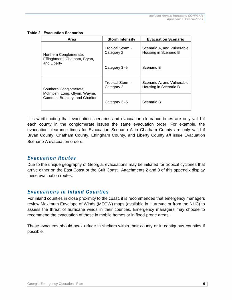
Incident Annex: Hurricane CONPLAN Appendix 2: Evacuations
Georgia Emergency Operations Plan 6
Table 2. Evacuation Scenarios Area Storm Intensity Evacuation Scenario
Northern Conglomerate: Effinghmam, Chatham, Bryan, and Liberty
Tropical Storm - Category 2
Scenario A, and Vulnerable Housing in Scenario B
Category 3 -5 Scenario B
Southern Conglomerate: McIntosh, Long, Glynn, Wayne, Camden, Brantley, and Charlton
Tropical Storm - Category 2
Scenario A, and Vulnerable Housing in Scenario B
Category 3 -5 Scenario B
It is worth noting that evacuation scenarios and evacuation clearance times are only valid if
each county in the conglomerate issues the same evacuation order. For example, the
evacuation clearance times for Evacuation Scenario A in Chatham County are only valid if
Bryan County, Chatham County, Effingham County, and Liberty County all issue Evacuation
Scenario A evacuation orders.
Evacuat ion Routes Due to the unique geography of Georgia, evacuations may be initiated for tropical cyclones that
arrive either on the East Coast or the Gulf Coast. Attachments 2 and 3 of this appendix display
these evacuation routes.
Evacuat ions in In land Count ies For inland counties in close proximity to the coast, it is recommended that emergency managers
review Maximum Envelope of Winds (MEOW) maps (available in Hurrevac or from the NHC) to
assess the threat of hurricane winds in their counties. Emergency managers may choose to
recommend the evacuation of those in mobile homes or in flood-prone areas.
These evacuees should seek refuge in shelters within their county or in contiguous counties if
possible.

Incident Annex: Hurricane CONPLAN Appendix 2: Evacuations
7 Georgia Emergency Operations Plan
EVACU ATION SUPPORT
Support for evacuations – either from the Georgia Coast, inland areas of Georgia, or for
evacuees traveling to Georgia from other states – requires a multilateral effort and the seamless
integration of multiple response plans. Support for evacuations may potentially include the
implementation of a one-way contraflow along I-16, staffing of traffic control points and critical
intersections, direct evacuee support, proactive evacuation route monitoring, and the
dissemination of concise and targeted public information.
Cont ra f low Operat ions for I -16 A one-way contraflow interstate plan for I-16 has been developed to provide additional roadway
capacity during hurricane evacuations. The execution of contraflow operations requires a
significant number of resources to implement and support; therefore, this plan is enacted only
when absolutely necessary to ensure the safety of the evacuating public.
The decision to implement a one-way (contraflow) plan for I-16 is made by the GDOT as part of
ESF #1 - Transportation in conjunction with the Incident/Unified Command. This decision will be
timed in coordination with the evacuation clearance times, so that the evacuating population is
safely out of vulnerable areas before the arrival of tropical storm force winds.
To facilitate the movement of evacuees from the westbound lanes to the eastbound lanes that
have been converted to westbound lanes on I-16, median crossover ramps have been
constructed at mile post 162 just east of Chatham Parkway in proximity to downtown Savannah,
and at mile post 158 just west of SR 307/Dean Forest Road. Normal two-way operations are
resumed west of US 441 near Dublin, where a third median crossover has been constructed.
The contraflow of the interstate adds an additional 125 miles of increased roadway capacity,
approximately, for evacuating citizens.
Travelers on the normal westbound lanes of I-16 can access all exits. Travelers on the
converted eastbound lanes can access select exits; a list of accessible exits is presented in
Table 3. Re-entering I-16 is accommodated by onramps on the westbound side.
Table 3. Exit Locations on Eastbound Lanes for Contraflow of I-16
County Exit Number Surface Road Bryan 143 SR 30
Bulloch 116 US 301
Candler 104 SR 23 / SR 121
Emmanuel 90 US 1
Treutlen 71 SR 15
Laurens 67 SR 29
Laurens 51 US 441
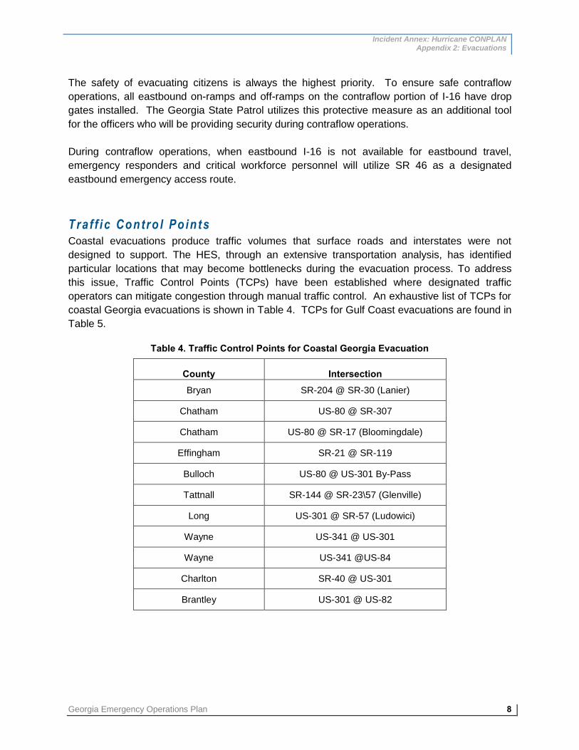
Incident Annex: Hurricane CONPLAN Appendix 2: Evacuations
Georgia Emergency Operations Plan 8
The safety of evacuating citizens is always the highest priority. To ensure safe contraflow
operations, all eastbound on-ramps and off-ramps on the contraflow portion of I-16 have drop
gates installed. The Georgia State Patrol utilizes this protective measure as an additional tool
for the officers who will be providing security during contraflow operations.
During contraflow operations, when eastbound I-16 is not available for eastbound travel,
emergency responders and critical workforce personnel will utilize SR 46 as a designated
eastbound emergency access route.
Tra f f i c Contro l Po in ts Coastal evacuations produce traffic volumes that surface roads and interstates were not
designed to support. The HES, through an extensive transportation analysis, has identified
particular locations that may become bottlenecks during the evacuation process. To address
this issue, Traffic Control Points (TCPs) have been established where designated traffic
operators can mitigate congestion through manual traffic control. An exhaustive list of TCPs for
coastal Georgia evacuations is shown in Table 4. TCPs for Gulf Coast evacuations are found in
Table 5.
Table 4. Traffic Control Points for Coastal Georgia Evacuation
County Intersection Bryan SR-204 @ SR-30 (Lanier)
Chatham US-80 @ SR-307
Chatham US-80 @ SR-17 (Bloomingdale)
Effingham SR-21 @ SR-119
Bulloch US-80 @ US-301 By-Pass
Tattnall SR-144 @ SR-23\57 (Glenville)
Long US-301 @ SR-57 (Ludowici)
Wayne US-341 @ US-301
Wayne US-341 @US-84
Charlton SR-40 @ US-301
Brantley US-301 @ US-82

Incident Annex: Hurricane CONPLAN Appendix 2: Evacuations
9 Georgia Emergency Operations Plan
Table 5. Traffic Control Points for Gulf Coast Evacuation
County (City) Intersection County (City) Intersection Atkinson (Pearson)
SR 31 @ SR 520 Lowndes (Lake Park) SR 7 @ SR 376
Atkinson (Pearson)
SR 31 @ Lott Ave. Lowndes (Lake Park) SR 376 @ Zeigler Road
Brooks (Quitman) SR 38 @ SR 333/Court St Lowndes (Lake Park) SR 376@ SR 401 N.B.R
Brooks (Quitman) SR 38 @ SR 76 / 333 Miller (Colquitt) SR 1 @ SR 45
Clinch (Homerville)
Clinch (Homerville) Mitchell (Camilla) SR 300 @ SR 37
Coffee (Douglas) SR 31 @ SR 135 Mitchell (Camilla) SR 300 @ SR 112
Colquitt SR 35 @ Pavo Rd./SR 33 Mitchell SR 300 @ Cagle
Colquitt SR 35 @ Tallokas Rd. Thomas SR 35 @ Metcalf Rd.
Colquitt SR 35 @ Magnolia Lane Thomas SR 35 @ Pinetree Blvd.
Colquitt (Moultrie) SR 35 @ 5th St. Thomas SR 35 @ Campbell
Colquitt (Moultrie) SR 35 @ SpenceField/SR 133
Thomas SR 35 @ Cairo Rd.
Colquitt (Moultrie) SR 35 @ Adel Rd./SR 37 Thomas SR 35 @ SR 38
Colquitt (Moultrie) SR 35 @ Rowland Drive Thomas SR 35 @ SR 3 Alt.
Colquitt (Moultrie) SR 35/SR 33@Tifton Rd./SR 35
Thomas SR 35 @ County Line Rd.
Dougherty SR 300 @ Holly Drive Thomas SR 38 @ SR 3/US19
Dougherty SR 300 @ Worth St./P&G Thomas SR 35 @ SR 188
Dougherty SR 300/520@ Turner Field Thomas SR 300 @ Williamsburg Ave.
Dougherty SR 300 @ Clark Ave Ext/SR 520
Thomas (Thomasville) SR 300 @ SR 122
Early (Blakely) SR 1 Bus. @ SR 39 Thomas (Thomasville) SR 300 @ SR 35Bus.
Echols (Statenville)
SR 11 @ SR 94 Thomas SR 300 @ SR 38
Grady (Cairo) SR 93 @ SR 111 Tift (Omega) SR 35 @ Oak St.
Grady (Cairo) SR 93/111@ MLK Tift (Tifton) SR 520 @ Virginia Ave./SR 35
Grady (Cairo) SR 93/111@ 1st SW Tift (Tifton) SR 520 @ SR 401 N.B.Ramps
Grady (Cairo) SR 93/111@ SR 38Spur Seminole (Donalsonville)
SR 38 @ SR 91
Grady (Cairo) SR 93/111@ 3rd. Seminole (Donalsonville) SR 38 @ SR 91Alt.
Grady (Cairo) SR 93/111@ SR 38 Lee SR 520 @ Fussell Road
Lee SR 520 @ Cookville Road

Incident Annex: Hurricane CONPLAN Appendix 2: Evacuations
Georgia Emergency Operations Plan 10
Cri t i ca l Roadway Segments and In tersect ions The transportation analysis in the HES has identified “critical roadway segments”; during an
evacuation, the level of congestion on these segments will have a significant effect on the flow
of traffic within the region. These critical roadway segments may experience congestion,
creating “bottlenecks” in the evacuation process. Table 6 presents these critical roadway
segments for a coastal Georgia evacuation. Table 7 displays critical intersections that may
become bottlenecks during an evacuation from the Gulf Coast; these critical intersections were
designated in the 2010 update of the Georgia Hurricane Plan.
Table 6. Critical Roadway Segments for Coastal Georgia Evacuation
County Critical Roadway Segment
Bryan
1. I-16 westbound out of region
2. SR 144 out of Bryan County at Liberty County line
3. I-95 northbound at Chatham County line
Chatham
1. I-16 westbound out of region
2. I-516 in Savannah
3. US 280 @ SR 292
Liberty
1. I-16 westbound out of region
2. US 84 at Fort Stewart
3. SR 119 across Fort Stewart property
Long 1. US 25/US 341 through Long County westbound out of region
McIntosh 1. US 341 westbound out of region
2. SR 57 westbound from I-85
Wayne 1. US 341 westbound out of region

Incident Annex: Hurricane CONPLAN Appendix 2: Evacuations
11 Georgia Emergency Operations Plan
Table 7. Critical Intersections for Gulf Coast Evacuation
County Potential Critical Intersection Atkinson 1. SR 89 / US 441 @ SR 520 / US 82
Brooks 1. SR 333 @ SR 76 / US 221
2. SR 333 @ SR 38 / US 84
Clinch 1. SR 89 / US 441 @ SR 38 / US 84
2. SR 89 / US 441 @ SR 94
Colquitt
1. SR 133 @ SR 35 / US 319
2. SR 35 / US 319 @ SR 37
3. SR 35 / US 319 @ SR 33 & SR 133
Decatur
1. SR 1 / US 27 @ SR 97
2. SR 1 / US 27 @ SR38 / US84
3. SR 1 / US 27 @ SR 241
4. SR 97 @ SR 302
Dougherty 1. SR 3 / US 19 @ SR 300
2. SR 520 / US 82 @ SR 300
Early 1. SR 1 / US 27 @ SR 62
Echols 1. SR 11 / US 129 @ SR 94
Grady 1. SR 111 @ SR 38 / US 84
Lanier 1. SR 11 / US 129 @ SR 38/US 84
2. SR 11 / US 129 @ SR 135 & US 221
Lowndes 1. SR 7 / US 41 @ SR 376
Miller 1. SR 91 @ SR 1 / US 27
Seminole 1. SR 91 @ SR 38 / US 84
Thomas 1. SR 3 / US 19 @ SR 35 / US 319
2. SR 111 @ SR 3 / US 19
Tift 1. SR 35 / US 319 @ SR 520 / US 82
Direct Evacuee Support – HERO Uni ts Evacuation can be a stressful process for evacuees as well as their vehicles. A vehicle that
becomes stranded or breaks down could potentially block traffic and hinder the overall progress
of the evacuation. GDOT’s Highway Emergency Response Operator (HERO) units are
available during evacuations to mitigate such issues. HEROs’ two primary goals are to provide
direct assistance to vehicles in distress and ensure the maximum throughput of vehicles along
evacuation routes. During evacuations, HERO units are deployed to evacuation routes, where
they traverse the routes throughout the evacuation to assist distressed motorists. HERO units
may provide a variety of services, including changing flat tires, jumping weak batteries,
providing vital vehicle fluids (fuel, coolant, etc.), providing road and travel information,
transporting travelers to safer areas, and providing use of a courtesy phone. If a vehicle is
blocking the roadway, a HERO unit can gently push the inoperable vehicle out of general traffic
lanes. The HERO units operation is overseen by ESF #1 – Transportation in conjunction with
the ERB.

Incident Annex: Hurricane CONPLAN Appendix 2: Evacuations
Georgia Emergency Operations Plan 12
Direct Evacuee Support - Law Enforcement Law enforcement resources provide direct evacuee support during evacuations. During
evacuations, law enforcement resources will repeatedly traverse evacuations routes responding
to requests for assistance. Law enforcement resources are able to direct support to distressed
evacuees, resolve legal issues, coordinate with local officials for additional support services,
and provide information on route conditions for further support. All law enforcement resources
will be coordinated by ESF-13: Public Safety and Security Services in conjunction with the ERB.
Real -T ime T ra f f i c Moni tor ing Real-time traffic monitoring allows state and local authorities to mitigate traffic issues in a timely
manner. There are a host of resources available to monitor traffic along evacuation routes.
GDOT’s “Navigator” is an advanced traffic management center headquartered in Atlanta. It
features traffic cameras, changeable message signs, ramp meters, and speed sensors to
monitor traffic speeds. In addition to providing critical information to local officials, much of this
information is accessible to the public via a website (http://www.georgia511.org) and by dialing
“511” anywhere in Georgia. Other resources for monitoring traffic during evacuations include
GDOT’s traffic counter network, aerial reconnaissance, and field reports.
Tra f f i c Counter Netw ork GDOT’s traffic counter network allows local officials to monitor the progress of the evacuation.
Traffic counters have been strategically placed along evacuation routes and major roadways
throughout the state. Local officials can compare real-time traffic counters with GDOT’s traffic
count database to determine the level of congestion along routes and how efficiently the
evacuation is progressing. Traffic counters provide situational awareness that enable
emergency managers to provide targeted support to segments of the evacuation route that
where traffic flow may be compromised. They also give a “big picture” of the evacuation traffic
pattern, allowing mass care partners to allocate resources to communities that are sheltering
evacuees.
Aer ia l Recon naissance Aerial reconnaissance is valuable in that it provides a large-scale, overall picture of the progress
of the evacuation. This tool allows local officials to quickly determine bottlenecks and direct
resources toward those locations. Aerial reconnaissance is especially useful for roadway
segments that may lack traffic counters to determine traffic volume. ESF #1 coordinates aerial
reconnaissance missions using state and local assets. Aerial reconnaissance is also utilized
after the storm passes to assess the level and extent of damage in impacted areas.

Incident Annex: Hurricane CONPLAN Appendix 2: Evacuations
13 Georgia Emergency Operations Plan
Fie ld Reports Field reports on the progress of the evacuation are a valuable source of ground-
truth information. These reports may be received by HEROs, law enforcement personnel,
GEMA/HS/HS/HS Field Coordinators, or other response personnel. The ERB will coordinate
the collection of this information and forward to appropriate parties in the SOC.
Publ ic In format ion When an evacuation order is issued, many citizens lack a disaster plan and rely on public
information to understand evacuation orders, locate support services, and determine the best
evacuation routes. To this end, ESF #15 – External Affairs plays a critical role in the evacuation
process. During an evacuation, and throughout the disaster response, ESF #15 coordinates the
dissemination of public information via a variety of mediums, including the internet, television,
social networking, and public radio. ESF #15’s public information activities are exercised as
part of the State Joint Information Center (S-JIC) and guided by the GEMA/HS/HS/HS Crisis
Communication Plan.
In te rnet Sources The internet is used increasingly as the primary source of information for many people. Many
disaster response partners maintain websites that provide critical information during
evacuations. GDOT’s Navigator website (http://www.georgia511.org), as mentioned previously,
provides real-time traffic information to the public. There is also a mobile-friendly version of the
site for people with internet-capable phones. The National Hurricane Center’s website
(http://www.nch.noaa.gov) provides information on the timing and impacts of the storm, as well
as the locations of any watches and warnings in effect. Local National Weather Service offices
in Charleston, Jacksonville, and Tallahassee (http://www.nws.noaa.gov) features information on
local impacts from the approaching storm, and often provides succinct weather briefing packets
as the threat increases. (The particular office issuing updates depends on the location of the
storm’s anticipated landfall.) GEMA’s website (http://www.GEMA/HS/HS.ga.gov) features
information on personal and business emergency preparedness, the location and status of
open shelters, as well as press releases and other pertinent Information about preparedness
and response for the tropical cyclone. Shelter location may also be obtained from the American
Red Cross (http://www.redcross.org).1
GEMA/HS, in coordination with the Georgia Department of Public Health, also has a mobile
phone application to aid in emergency preparedness. The “Ready Georgia” app features real-
time weather and hazard alerts for the user’s location, as well as customized, location-specific
maps, stream gauge data (for flooding risk), and local disaster history. The app also features
tools for the user to develop emergency plans and update an emergency supplies checklist. In
addition,
1 This list of websites is not intended to be exhaustive.

Incident Annex: Hurricane CONPLAN Appendix 2: Evacuations
Georgia Emergency Operations Plan 14
users can access general information on a variety of threats and recommended preparedness
measures.
Telev is ion Television is widely utilized to convey and receive critical information on emergency information.
Emergency response partners, through coordination with S-JIC, will provide accurate
information to the media on the evacuation progress and any pertinent updates. During
emergencies, emergency management personnel and elected officials hold televised briefings
from the SOC. All television briefings and interviews are coordinated by the S-JIC.
Socia l Networking Social networking is an emerging and increasingly popular method for sharing and receiving
information. Through the use of Real Simple Syndication (RSS) data feeds, and other
outlets such as Twitter and Facebook, GEMA/HS/HS/HS and emergency response partners
can provide accurate and timely information about evacuation and other preparedness
measures to the public.
RSS feeds from GEMA/HS/HS/HS/HS/HS include press releases2 and a Daily Media
Summary3. The GEMA/HS/HS Facebook page provides prompt updates on emergency
information to those that “like” the page.4 Likewise, the GEMA/HS Twitter feed provides
emergency information updates to the page’s “followers.”5
Publ ic Radio The advantage of public radio is that it is widely available to evacuating citizens’ vehicles,
making it a prime outlet for outreach. Most areas receive broadcast signals from AM and FM
radio; local stations will very likely provide coverage of the approaching storm and details on the
ongoing evacuation.
During an evacuation, the Georgia Public Broadcast (GPB) radio network’s 15 radio stations will
broadcast information to evacuees concerning traffic conditions along evacuation routes, hotel
and motel availability, any fuel shortages, and the locations and availability of public shelters.
The radio stations in GPB’s network are strategically located such that there is coverage along
all evacuations routes. To inform evacuees of this source of information, signs along evacuation
routes display the pertinent radio station for that area. A map and list of these radio stations are
presented in Attachment 4.
2
3
4
5
http://www.piersystem.com/go/feed/759/ru/rss http://www.GEMA/HS/HS.ga.gov/rss_generator.nsf/rss?openagent&uid=1092DF874B632B6A85257559004E952A http://www.facebook.com/GEMA/HS.OHS http://twitter.com/GeorgiaEMA

Incident Annex: Hurricane CONPLAN Appendix 2: Evacuations
15 Georgia Emergency Operations Plan
Georg ia 511 By dialing “511” anywhere in Georgia, citizens can access real-time traffic information and
request motor vehicle assistance 24 hours a day. Much of the information from the Georgia
Navigator system is available through Georgia 511, including information on trip times, route-
specific congestion and incidents, and current and planned lane and road construction.
Portab le Var iab le Message Boards When evacuation orders are issued, GDOT will place portable variable message boards in
strategic locations along evacuation routes to provide targeted information to evacuees along
that route. Information displayed on the boards will include exit information for contraflow
operations, shelter availability, radio station listings, and other pertinent information.

Incident Annex: Hurricane CONPLAN Appendix 2:Evacuations
Attachment 2: Coastal Georgia Evacuation Routes
Georgia Emergency Operations Plan 1
Incident Annex: Hurricane CONPLAN Appendix 2: Evacuations Attachment 2: Coastal Georgia Evacuation Routes
COASTAL GEORGIA EVACUATION ROUTES MAP
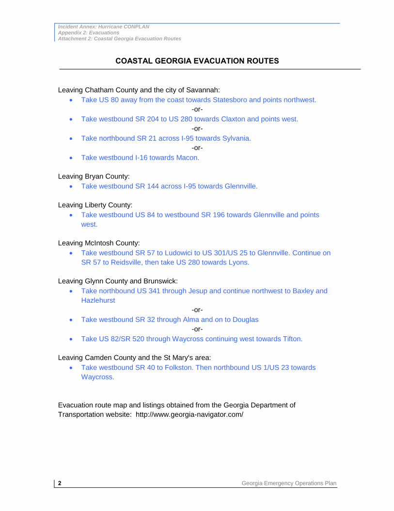
Incident Annex: Hurricane CONPLAN Appendix 2: Evacuations Attachment 2: Coastal Georgia Evacuation Routes
2 Georgia Emergency Operations Plan
COASTAL GEORGIA EVACUATION ROUTES
Leaving Chatham County and the city of Savannah:
Take US 80 away from the coast towards Statesboro and points northwest.
-or-
Take westbound SR 204 to US 280 towards Claxton and points west.
-or-
Take northbound SR 21 across I-95 towards Sylvania.
-or-
Take westbound I-16 towards Macon.
Leaving Bryan County:
Take westbound SR 144 across I-95 towards Glennville.
Leaving Liberty County:
Take westbound US 84 to westbound SR 196 towards Glennville and points
west.
Leaving McIntosh County:
Take westbound SR 57 to Ludowici to US 301/US 25 to Glennville. Continue on
SR 57 to Reidsville, then take US 280 towards Lyons.
Leaving Glynn County and Brunswick:
Take northbound US 341 through Jesup and continue northwest to Baxley and
Hazlehurst
-or-
Take westbound SR 32 through Alma and on to Douglas
-or-
Take US 82/SR 520 through Waycross continuing west towards Tifton.
Leaving Camden County and the St Mary's area:
Take westbound SR 40 to Folkston. Then northbound US 1/US 23 towards
Waycross.
Evacuation route map and listings obtained from the Georgia Department of
Transportation website: http://www.georgia-navigator.com/

Incident Annex: Hurricane CONPLAN Appendix 2:Evacuations
Attachment 3:Gulf Coast Evacuation Routes
Georgia Emergency Operations Plan 1
Incident Annex: Hurricane CONPLAN Appendix 2: Evacuations Attachment 3: Gulf Coast Evacuation Routes
GULF COAST EVACUATION ROUTES MAP

Incident Annex: Hurricane CONPLAN Appendix 2: Evacuations Attachment 3: Gulf Coast Evacuation Routes
2 Georgia Emergency Operations Plan
GULF COAST EVACUATION ROUTES
Entering Georgia on northbound I-75 (from Florida):
Take northbound I-75 north through Valdosta and Tifton to Cordele and points north.
Entering Georgia on northbound US 319 (from Tallahassee area):
Take northbound US 319 through Thomasville and on to Moultrie, Tifton, and points
north.
-or-
Take northbound US 319 to Thomasville and then US 19/SR 3 to Albany and then
westbound US 82 to Dawson.
-or-
Take northbound US 319 to Thomasville and then US 19/SR 3 to Albany and then
northbound SR 300 north to Cordele.
Entering Georgia on northbound US 27 (from Tallahassee area):
At the Georgia state line, take SR 111 through Cairo and on to Meigs. Then take
northbound US 19/SR 3 to Albany. Then take northbound SR 300 to Cordele.
-or-
At the Georgia state line, continue on US 27/SR 1 through Bainbridge, Colquitt, Blakely
and on to Cuthbert.
Entering Georgia on SR 302 (via Florida's SR 267/Quincy area):
Take northbound SR 302 to SR 97 north to Bainbridge. Then take northbound US 27
through Colquitt and Blakely.
Entering Georgia on SR 241 (via Florida's SR 65/Quincy area):
Take northbound SR 241 to Attapulgus. Then take northbound US 27 through
Bainbridge, Colquitt and Blakely.
Entering Georgia on SR 97 (from US 90 in Florida):
Take SR 97 through Faceville and on to Bainbridge. Then take northbound US 27
through Colquitt and Blakely.
Entering Georgia on US 221/SR 76 (from Greenville, Florida):
Take northbound US 221 to Quitman. Then take northbound SR 333 to New Rock Hill.
Then take northbound SR 133 to Moultrie and northbound US 319 to Tifton.
Entering Georgia on SR 333 (from Florida's SR 53):
Take northbound SR 333 to Quitman. Continue on northbound SR 333 to New Rock Hill.
Then take northbound SR 133 to Moultrie and northbound US 319 to Tifton.
Entering Georgia on SR 31 (from Florida's SR 145):

Incident Annex: Hurricane CONPLAN Appendix 2:Evacuations
Attachment 3:Gulf Coast Evacuation Routes
Georgia Emergency Operations Plan 3
Take northbound SR 31 to I-75. Then take northbound I-75 to Cordele and points north.
Entering Georgia on US 441 (from Florida):
Take northbound US 441 through Edith and Homerville and on to Douglas.
Entering Georgia on northbound US 129 (from Jasper, Florida):
Take northbound US 129 to Statenville. Then take westbound SR 376 to northbound US
41 to northbound I-75.
Entering Georgia on SR 94 (from Florida's SR 2):
Take northbound SR 94 to Edith. Then take northbound US 441 to Homerville and on to
Douglas.
Entering Georgia on SR 91 (from Alabama's SR 2/Malone area):
Take SR 91 through Donalsonville to Colquitt. Then take northbound US 27 to Blakely
and Cuthbert.
Entering Georgia on SR 62 (from Alabama's SR 52/Dothan area):
Take SR 62 to Blakely. Then take northbound US 27 towards Cuthbert.
Evacuation route map and listing obtained from the Georgia Department of Transportation
website: http://www.georgia-navigator.com/

Incident Annex: Hurricane CONPLAN Appendix 2: Evacuations Attachment 4: GPB Radio Coverage Map
1 Georgia Emergency Operations Plan
Incident Annex: Hurricane CONPLAN Appendix 2: Evacuations Attachment 4: Georgia Public Broadcasting Radio Coverage
GEORGIA PUBLIC BROADCASTING RADIO COVERAGE MAP

Incident Annex: Hurricane CONPLAN Appendix 2: Evacuations
Attachment 4: GPB Radio Coverage Map
Georgia Emergency Operations Plan 2
GEORGIA PUBLIC BROADCASTING RADIO STATION LIST
Radio Station Frequency Broadcast City
WUNV 91.7 FM Albany
WUGA 91.7 / 97.9 FM Athens
WACG 90.7 FM Augusta
WWIO 88.9 FM Brunswick
WUWG 90.7 FM Carrollton
WNGH 98.9 FM Chatsworth
WJSP 88.1 FM Columbus
WPPR 88.3 FM Demorest
WNGU 89.5 FM Dahlonega
WJWV 90.9 FM Fort Gaines
WDCO 89.7 FM Macon
WGPB 97.7 FM Rome
WSVH 91.1 FM Savannah
WWIO 1190 AM St. Mary’s
WABR 91.1 FM Tifton
WWET 91.7 FM Valdosta
WXVS 90.1 FM Waycross

Incident Annex: Hurricane CONPLAN Appendix 3: Post-Hurricane Re-Entry
1 Georgia Emergency Operations Plan
Incident Annex: Hurricane CONPLAN Appendix 3: Post-Hurricane Re-Entry
INTRODUCTION
Both coastal and inland Georgia are vulnerable to tropical cyclone related hazards. When a
tropical cyclone directly impacts Georgia, it is incumbent upon the state government, local
governments, and partnering organizations to combine resources and initiate a response effort.
This appendix to the Hurricane CONPLAN outlines the strategy for re-entering impacted areas
immediately following a tropical cyclone impact in Georgia.
Re-entry is the phase of response that refers to accessing impacted areas immediately after the
passage of a tropical cyclone. In Georgia, a phased approach to re-entry is employed. This
phased approach is designed to minimize the public’s exposure to hazardous conditions
prevalent in the impacted areas.
Changes to or designation of particular re-entry phase levels as described further in this
appendix shall be determined by local county officials and conveyed to the State Operations
Center for further dissemination to state partners working in or responding to impacted counties.
Users of this document should understand that although re-entry phases have been defined to
provide consistency and clarity across jurisdictional borders, neighboring counties or
communities within a county may be operating under different re-entry phases at the same time
due to operating conditions.
Purpose The purpose of this appendix is to provide a consistent overview of re-entry operations for an
Atlantic hurricane impact, in order for state and local emergency management personnel to
better support local operations.
Scope
GEMA/HS and coastal county emergency management agencies have developed four phases
of re-entry for a hurricane landfall in Georgia. Each of these phases may be subdivided or be
subject to additional restrictions based on conditions at the time of the storm’s impact. Re-entry
operations include a number of activities, including gaining access to impacted areas;
establishing control points to limit access to impacted areas until hazards have been cleared;
the abatement of hazardous conditions within impacted areas; and phasing access for non-
responders/citizens into impacted areas as conditions warrant. These activities span timeframes
of hours to weeks.

Incident Annex: Hurricane CONPLAN Appendix 3: Post-Hurricane Re-Entry
Georgia Emergency Operations Plan 2
The scope of this appendix does not include strategies or protocols for immediate life-safety
response missions (including search and rescue (SAR)) or logistics. All strategies pertain to
land-based operations only.
SITUATION
Inc ident Condi t ion A tropical cyclone – especially a major hurricane – has the potential to create widespread
catastrophic damage along both the coast as well as inland areas. It is assumed that re-entry
capabilities will require expedited augmentation in certain mission critical areas:
Bridge Inspections (ESF #1): Bridge inspection strike teams and deep water bridge
inspection strike teams will be required to support onward movement of re-entry teams.
Communications (ESF #2): Communications infrastructure likely will sustain damage,
rendering many systems inoperable and leaving gaps in communications over a wide
area. Communications support will be needed to support re-entry task forces and strike
teams, as well as personnel at the Forward Staging Areas (FSAs), the Logistics Staging
Area (LSA), bases, and camps.
Debris Clearing (ESF #3): The amount of debris generated by storm surge and hurricane
force winds – compounded by the prevalence of pine forests in Georgia – will require a
tremendous road debris clearing effort. Heavy equipment will be needed to aid the re-
entry task forces during initial phases of re-entry.
Fire Suppression (ESF #4): Re-entry task forces may require fire suppression strike
teams to provide support for ongoing fires in impacted areas.
Commodities (ESF #7): Re-entry task forces and support strike teams will require life-
sustaining commodities prior to and after the onset of hurricane related hazards.
Augmented commodities may be required for extended re-entry operations.
Medical Support (ESF #8): Medical support strike teams will support re-entry task forces
to support any medical needs that may arise during re-entry operations.
Hazardous Materials (ESF #10): Along the coast are numerous facilities that store a
variety of hazardous materials. Re-entry task forces may require support for air
monitoring and hazardous chemical identification.

Incident Annex: Hurricane CONPLAN Appendix 3: Post-Hurricane Re-Entry
3 Georgia Emergency Operations Plan
Security (ESF #13): Re-entry task forces and support strike teams will require security
during operations. Security will also be required to protect commodities in transport as
well as resources at staging areas.
Planning Assumpt ions If Georgia is threatened by a tropical cyclone, particularly a major hurricane, the state
will likely declare a State of Emergency to utilize state-level assets for emergency
response. Depending on forecasted intensity of the tropical cyclone, a pre-disaster
Presidential Disaster Declaration may also be issued.
A major hurricane’s landfall on the Georgia coast will likely produce catastrophic damage
along a significant portion of the coast.
A comprehensive re-entry operation requires preparatory time upwards of 72 hours.
Damage to communications infrastructure will be widespread in the impacted areas,
likely rendering communications networks inoperable. Commercially-available
communications networks will likely be overwhelmed with demand upon re-entry by
citizens. In the initial phases of re-entry and throughout the operation, communications
augmentation will be required to support response personnel, re-entry task forces,
support strike teams, personnel at forward incident facilities, and other responding
parties.
The electrical power infrastructure will sustain widespread impacts along coastal areas
and inland communities, potentially leaving thousands of homes and businesses without
power.
Re-entry task forces will encounter significant debris on re-entry routes during the initial
phase of operations. Debris may include downed trees, electric transmission and
distribution poles and other infrastructure, and other natural and manmade obstacles.
A phased approach to re-entry is employed to limit access into hazardous areas. The
degree of damage and threat from hazards will vary across the impacted region; this will
determine which phase of re-entry will be in effect in a particular area.
Forward staging facilities will be sited in close proximity to impacted areas but away from
the most hazardous conditions. Generally, for a tropical storm or Category 1-3
hurricane, facilities will be placed in closer proximity to the coast; for a major hurricane,
facilities will be sited further inland.
Forward staging facilities will likely be established 24 to 48 hours prior to the forecasted
onset of sustained tropical storm-force winds (39 mph) along the coast.

Incident Annex: Hurricane CONPLAN Appendix 3: Post-Hurricane Re-Entry
Georgia Emergency Operations Plan 4
The Evacuation and Re-entry Branch (ERB) will be activated roughly 24 to 48 hours
prior to the anticipated issuance of early/voluntary or mandatory evacuation orders. The
ERB will remain activated and conduct operations through the conclusion of re-entry
operations.
CONCEPT OF OPER ATIONS
In t roduct ion
A hurricane that makes landfall on or near the Georgia coast will produce widespread and
perhaps catastrophic damage. Re-entry operations are designed to allow access into impacted
areas for search and rescue, debris removal, commodities distribution, infrastructure restoration,
and recovery.
Georgia utilizes phased re-entry operations. This approach is strategically designed to allow
only emergency response personnel – re-entry task forces, support strike teams, critical work
force teams, etc – to access to impacted areas until hazardous conditions have been mitigated
or have abated for the general public.
A comprehensive logistics structure will support re-entry during all phases. Security checkpoints
and re-entry permits will be utilized during Phase 1 to allow critical workforce to gain access into
restricted areas.
Organiza t ion – Genera l Numerous operational facilities are required to enact and support an effective re-entry
operation. Operational facilities mentioned herein are detailed in the GEOP Support Annex C:
Logistics Management.
Approximately 72 hours of preparatory time is required to facilitate a comprehensive re-entry
operation. The preparatory time reflects the time required to establish pertinent operational
entities.
State Operations Center The GEMA/HS State Operations Center (SOC) will maintain full control of all state
operations throughout re-entry. Operational control of all re-entry and forward operations
centers will occur at the SOC.
During hurricane season (June 1 – November 30), the SOC is in a monitoring phase. GEMA/HS
will continue to monitor tropical conditions when a tropical cyclone forms in the Atlantic basin. A
transition to a partial activation will begin when a tropical cyclone poses a threat to Georgia. A
recognized threat may emerge as early as 120 hours from anticipated landfall; however,
changes in forecast track, an advance in forward speed, or formation of a cyclone in close

Incident Annex: Hurricane CONPLAN Appendix 3: Post-Hurricane Re-Entry
5 Georgia Emergency Operations Plan
proximity to the coast may reduce this lead time. Typically, when a tropical cyclone is forecasted
to impact Georgia within 72 hours, forward operations centers are established.
Evacuat ion and Re -En try Branch The SOC employs the Incident Command System to conduct disaster operations. The ERB is a
branch of the Operations Section within the SOC and is tasked with managing evacuation and
re-entry operations. The ERB begins operations upon the issuance of local evacuation orders or
when evacuees from other states travel to Georgia. Typically, for a direct threat to the coast, the
ERB will begin operations roughly 72 hours prior to the onset of tropical storm-force winds.
Once evacuations are complete, the ERB and other forward personnel await the passage of the
tropical cyclone and the abatement of hazardous weather conditions. Once conditions are
deemed safe for re-entry, the ERB oversees re-entry task forces and support strike teams
during tactical operations.
Logist i cs Stag ing Area The State Logistics Staging Area (LSA) is a site where Initial Response Resources (IRR),
including food, water, ice, tarps, and other life supportive commodities, are re-located prior to
disaster response operations. Commodities are transported to the LSA throughout re-entry as
needed. Integration of these resources, for ground-based operations, into a coastal response
effort will occur during Phase II of re-entry. Additional information about the LSA can be found in
the GEOP Support Annex C: Logistics Management.
Forward S tag ing Area A forward staging area (FSA) is where re-entry task force and support strike team equipment is
staged prior to hurricane landfall. Depending on the location of landfall and anticipated extent of
the impacted areas, multiple FSAs may be established. Re-entry task force teams and support
strike teams deploy from FSAs to conduct tactical re-entry missions. FSAs support operations
during both Phase 1 and Phase 2 of re-entry.
A number of pre-determined sites have been designated as potential FSA locations. The
locations are strategically located in close proximity to the coast. Two routes –I-16 to the north
and U.S. 82 to the south – serve as the primary east-west re-entry routes, with secondary pre-
designated re-entry routes stemming from them.
The tropical cyclone threat is closely analyzed to determine FSA locations. Typically, for
hurricanes of lower intensity (1-2), FSAs are located in closer proximity to the coast than for
major hurricanes (Categories 3-5). The objective is to site FSAs to serve both the northern and
southern coastal areas and to site them in such areas where there is no threat of hurricane-
force winds after landfall.

Incident Annex: Hurricane CONPLAN Appendix 3: Post-Hurricane Re-Entry
Georgia Emergency Operations Plan 6
Base A base is a location where life-supportive services are provided to personnel and emergency
responders. A base is intended to provide the most comprehensive suite of life-supportive
services to responders and will likely serve large numbers of personnel. A base is also intended
to potentially serve as a forward operations center should the need arise.
Camp A camp is a smaller version of a base and offers requisite life supportive services to responders.
Camps are intended to support personnel in more forward locations within or in close proximity
to impacted areas. Camps provide support for fewer numbers of personnel than a base would
and are not intended to function as a command and control site. Camps are established to
support FSAs prior to, during, and after tropical cyclone impacts as needed.
Temporary Refuel ing Po in t Temporary Refueling Points (TRPs) are locations where re-entry task forces, support strike
teams, and other disaster response personnel refuel vehicles and equipment. The locations of
TRPs are determined dynamically by the ERB in conjunction with the SOC and ESF #12.
Additional information about TRPs can be obtained in the GEOP Annex C: Logistics
Management.
RE-ENTRY TASK FORCES AND SUPPORT STRIKE TE AMS
Re-en try Task Forces Re-entry task forces are the first teams to deploy from FSAs to carry out ground-based tactical
operations, including debris removal and utility restoration. A comprehensive coastal response
effort is anticipated to require upwards of 32 re-entry task forces. The teams are deployed from
FSAs and travel along pre-designated routes. Typically, interstate are given the first priority for
clearance, followed by US routes, state routes, and arterial roads.
Re-entry task forces are led by a GDOT Task Force Leader and are comprised of personnel
from multiple state agencies and private-sector partners, including GDOT, GFC, DNR, DPS,
Georgia DOD, Georgia Electric Membership Corporation (EMC) and member EMCs, Georgia
Power, and Georgia Transmission Corporation (GTC). It is anticipated that personnel will
encounter a tremendous amount of debris, especially from downed trees and power lines.
Georgia Power, GTC, and EMCs will ensure that each of the re-entry task forces will possess
the capability to neutralize downed transmission and distribution lines. GDOT and GFC will
clear fallen trees and other debris using a variety of equipment, including chainsaws, front end
loaders, backhoes, bulldozers, motor graders, and dump trucks. DPS and DNR will provide
security for the teams as needed.

Incident Annex: Hurricane CONPLAN Appendix 3: Post-Hurricane Re-Entry
7 Georgia Emergency Operations Plan
Support St r ike Teams Support strike teams are coordinated by the ERB and may or may not be staged prior to the
onset of tropical cyclone-related hazards. These strike teams will be coordinated and utilized as
the need arises. Each of the teams is typically comprised of a strike team leader and a subject
matter expert (e.g., inspector, officer, etc).
Bridge Inspection/Assessment Strike Team
This team inspects shallow water bridges and road bridges for potential damage.
Deep Water Bridge Inspection/Assessment Strike Team
This team inspects deep water bridges and road bridges for potential damage.
Law Enforcement Strike Team
This team of law enforcement officers staffs check points and provides security for the re-entry
task forces as needed.
Medical Support Strike Team
This team is comprised of at least two medical support personnel with an ambulance and basic
life support supplies and equipment.

Incident Annex: Hurricane CONPLAN Appendix 3: Post-Hurricane Re-Entry
Georgia Emergency Operations Plan 8
PHASED RE -ENTRY
Phase I : Render Safe Task Force Team Entry Phase I is the initial phase of re-entry. At this time, teams from state and local response
agencies as well as private sector utility providers will gain access to impacted areas. The
primary objective of personnel operating during this phase is to render the area safe for the first
responders who will follow then to conduct life safety operations.
Most likely, members of the Render Safe Task Forces will be co-located immediately before re-
entry operations begin in defined staging areas inland. These teams will be the first officials to
enter restricted areas; therefore, re-entry passes will not be required (as the task forces will
have embedded law enforcement officials). Nearly all elements of this group will likely be
operating emergency response vehicles with obvious agency or company markings.
Phase I will begin after the abatement of tropical storm force winds (34 knots / 39 mph) and
when conditions at FSAs from the passing hurricane are deemed safe by on-site re-entry task
force leaders. Re-entry task forces will deploy from the FSAs along the pre-designated re-entry
routes and conduct debris clearing into coastal areas to allow ground-based response
resources access into impacted areas.
The ERB may utilize aerial reconnaissance during Phase I operations. Aerial reconnaissance
may be used to assist the ERB in determining the status of and impacts to re-entry routes, and
to determine areas experiencing ongoing hazardous conditions. Aerial reconnaissance will be
coordinated by ERB in conjunction with ESF #1: Transportation, Aviation Unit and the Aviation
Support Operations Center (ASOC). Aerial reconnaissance resources that may be utilized
during Phase I include, but are not limited to: Georgia National Guard satellite imagery, fixed
and rotary wing assets, elements of the State Aviation Authority, the GFC, the Department
Natural Resources (DNR), and the Civil Air Patrol (CAP). Upon re-entry, utilities crews on the
Render Safe Task Forces will ensure the safe handling and removal of electric transmission and
distribution lines. GDOT and GFC resources will oversee the clearing of trees and other types of
debris. GDOT will inspect roadways and provide approval ratings for travel on re-entry routes.
Phase I I : Emergency Response and L i fe Safe ty Cr i t i ca l Workfo rce Re-Ent ry
Phase IIA: Critical Workforce Conducting Life Safety Operations
Phase IIA will consist of personnel conducting life safety operations in impacted areas. These
operations include, but are not limited to, search and rescue, emergency medical services, fire
suppression, hazardous materials control and containment, preliminary damage assessment,
essential relief staff to critical medical facilities and immediate utility restoration to critical
incident facilities. Personnel entering impacted areas in this phase are expected to present
employee credentials as well as a valid, state-issued identification card to public safety
Incident Annex: Hurricane CONPLAN Appendix 3: Post-Hurricane Re-Entry
9 Georgia Emergency Operations Plan
personnel controlling access. In limited situations, private sector personnel may be required to
possess a State of Georgia Critical Workforce Disaster Re-Entry Permit. These permits are
issued to private sector personnel that meet the criteria established above for re-entry in Phase
IIA, under the authority of the local Emergency Management Director in the impacted area.
Phase IIB: Essential Infrastructure Emergency Support Personnel
Phase IIB will consist primarily of individuals in the public and private sector who can restore
critical infrastructure operations in support of re-entry by the general public. These critical
infrastructure systems and networks include, but are not limited to, petroleum distributors, food
distributors, non-emergency medical facilities (such as dialysis centers), pharmaceutical
providers, members of the media, medical facility support staff, and local government essential
workers. Re-entry during this phase will require close coordination among local emergency
management and local public safety officials to ensure that the appropriate individuals are being
allowed to access damaged areas.
Phase III: Local Residents, Property Owners, and Business Owners
Phase III will consist of local residents and those who own property or businesses in the
impacted areas. This phase may be initiated one or more weeks after initial re-entry; the
timeframe is dependent on the extent of the storm damage and the status of recovery and
restoration operations in the preceding phases. For various reasons, access during this phase
may be the most challenging to control. Residents and individuals attempting to gain access
during this phase will be expected to present valid state-issued photo identification that includes
an address in the impacted area; or, valid state-issued photo identification along with a property
deed, recent utility bill verifying an address, current voter registration card, recent property tax
statement, business credential, or paystub from a local business. During Phase III re-entry,
access may be limited to certain portions of impacted counties, and restrictions may be in place
only allowing access during daylight hours.
Phase IV: Open to Public with Limited Access
In Phase IV, local officials will determine that a county or portions of the county are relatively
safe for entrance by the general public. Restrictions may remain in place for a period of time
limiting access to daylight hours.
ACCESS DURING RE -ENTRY
The State of Georgia Critical Workforce Disaster Re-Entry Permit Program is designed to
prevent additional loss of life during response and recovery by restricting access to entities that
have a role in life safety, mitigation of hazardous conditions, and critical infrastructure
restoration.
Local elected officials implement restricted access as specified in the description of re-entry
phases within this appendix. When possible, local law enforcement will support access control;

Incident Annex: Hurricane CONPLAN Appendix 3: Post-Hurricane Re-Entry
Georgia Emergency Operations Plan 10
when this is not possible, the ERB will use all available information to determine if restricted
access is necessary and will utilize state-level resources to execute the decisions. The ERB,
along with ESF #13 - Public Safety and Security coordinates state support for access control.
Access into restricted areas is granted by the check point and solely at the discretion of the law
enforcement personnel. Disaster response resources that have a role in mitigating or abating
hazardous conditions will be granted immediate access. To augment this process, GEMA/HS
and local EMAs distribute access permits to entities and organizations that are deemed to be
part of the critical workforce. Additional information pertaining to the Georgia Critical Workforce
Disaster Re-entry Permits can be found in the Georgia Critical Workforce Disaster Re-entry
Permits – Standard Operating Procedure.
RE-ENTRY ROUTES
The following section presents re-entry routes identified for the northern and southern portions
of coastal Georgia.
Table 1: Re-Entry Routes for Northern Georgia Coast Re-Entry Route Origin/Destination
I-16 to I-95 Metter to Savannah
SR 129 to US 280 to SR 30/SR 204 Metter to Claxton to Pembroke to Savannah
SR 129 to US 280 to US 301 to SR 144 Metter to Richmond Hill
SR 121 to SR 21 Millen to Savannah
SR 121 to US 80 Metter to Statesboro to Savannah
SR 129 to US 280 to US 301 to SR 57 to I-95 Metter to Claxton to Glenville to Ludowici
SR 129 to US 280 to US 301 to SR 196 to US 84 to I-95 Metter to Claxton to Glenville to Hinesville
Table 2: Re-Entry Routes for Southern Georgia Coast Re-Entry Route Origin/Destination
SR 520 Waycross to Brunswick
US 1 to US 40 Waycross to Folkston to St. Marys
US 84 to SR 32 to SR 99 to US 341 Waycross to Patterson to Sterling to Brunswick
US 84 to US 341 Waycross to Jesup to Brunswick

Incident Annex: Hurricane CONPLAN Appendix 4: Geographic Area Command
1 Georgia Emergency Operations Plan
Incident Annex: Hurricane CONPLAN Appendix 4: Geographic Area Command
INTRODUCTION
Purpose Geographic Area Command shall be established to oversee the management of an area
consisting of multiple counties that anticipates an allocation of numerous state resources and/or
have multiple incident management teams (IMTs) assigned. The purpose of Geographic Area
Command is to provide command authority and coordination of state resources for
simultaneous incident response in multiple jurisdictions.
Scope & Appl i cab i l i ty The Geographic Area Command Annex provides a framework for managing an incident large in
geographic scope. Geographic Area Command is a component of Command and Control under
the National Incident Management System (NIMS) and is in compliance with the National
Response Framework (NRF). The Geographic Area Command structure does not supplant the
Incident Command (IC) or Unified Command (UC); rather, it supports and provides direction for
existing protocols and procedures. The purpose of the Geographic Area Command structure is
oversee the management of the incident(s) with a focus on cohesive direction from the State
Operations Center (SOC) to individual counties; strategic assistance provided to individual
areas or jurisdictions, prioritizing limited resources for the most critical needs; and to provide for
interagency coordination of an incident or incidents among State and local authorities, as well
as across agencies within these jurisdictions.
Glossary o f Terms Geographic Area Command: An organization established to oversee the management of
multiple incidents that are each being handled by a separate Incident Command System
organization or to oversee the management of a very large or evolving incident that has multiple
incident management teams engaged. The Director of GEMA/HS or his or her designee(s)
makes the decision to establish a Geographic Area Command. Geographic Area Command is
activated only if necessary, depending on the complexity of the incident and incident
management span-of-control considerations.
Incident Command (IC): Entity responsible for overall management of the incident. Consists of
the Incident Commander, either single or unified command, and any assigned supporting staff.
Unified Command (UC): An Incident Command System application used when more than one
agency has incident jurisdiction or when incidents cross political jurisdictions. Agencies work
together through the designated members of the UC, often the senior person from agencies

Incident Annex: Hurricane CONPLAN Appendix 4: Geographic Area Command
Georgia Emergency Operations Plan 2
and/or disciplines participating in the UC, to establish a common set of objectives and strategies
and a single Incident Action Plan.
State Operations Center (SOC): Typically, the State Operations Center (SOC) refers to the
physical location at which the coordination of information and resources to support those
incidents and or events that warrant a significant state response. The current Georgia SOC is
co-located with GEMA/HS Headquarters in Atlanta, GA. Alternate SOCs are identified and may
be activated when necessary. In this context of this appendix, the SOC shall refer to the
authority held by GEMA’s Director of Operations or his or her designee(s).
Planning Assumptions
A. Geographic Area Command will be established by the Director of the Georgia
Emergency Management Agency/Office of Homeland Security or his or her designee.
B. The Geographic Area Command structure shall be patterned after ICS Command and
General Staff positions, in accordance with the National Incident Management System
(NIMS) and the National Response Framework (NRF).
C. Geographic Area Command staff shall be given written, delegated authority to
accomplish established objectives. This delegation of authority shall be conveyed to
local jurisdictions, all members of the Georgia Emergency Operations Command, and
state agencies with emergency responsibilities as identified in the Georgia Emergency
Operations Plan.
D. The Geographic Area Command structure does not supplant the Incident Command (IC)
or Unified Command (UC); rather, it supports and provides direction for existing
protocols and procedures.
CONCEPT OF OPER ATIONS
Act ivat ion When it is anticipated there will be a need to activate Geographic Area Command, the State
Operations Center shall convene to designate Area Commanders and other staff as
appropriate. These selections shall be approved by the Director of GEMA/HS. When
Geographic Area Command is activated, Area Commanders will be designated and given
appropriate delegations of authority in the form of written Delegation of Authority statements.
These written statements will help to eliminate confusion and provide the Area Commanders
with the authority to prioritize resources within their assigned areas. Each county within a
Geographic Area Command shall be notified that Geographic Area Command has been
established. When Geographic Area Command is activated, the SOC shall determine the scale of the
organization based on incident response needs. This information shall be conveyed to the Area
Commander. The SOC shall designate staff for the Command Post. While the SOC has final
authority regarding staffing, the Area Commander’s opinion and concurrence should be sought.
Incident Annex: Hurricane CONPLAN Appendix 4: Geographic Area Command
3 Georgia Emergency Operations Plan
During activation, the SOC and Area Commander should agree on support needs (i.e.,
computers, printers, communication systems). The Area Commander and SOC should also
establish initial operating procedures.
After Geographic Area Command has been activated and command staff has been designated,
the Area Commander shall provide guidance to command staff on the scope of the assignment;
convey the expectations, guidance, and authority of the SOC to command staff; and assign
tasks to command staff as appropriate. Also, command staff shall clarify their individual roles
and responsibilities and confirm individual support needs.
Dut ies and Responsib i l i t i es In general, Geographic Area Command personnel are responsible for:
1. Supporting overall incident-related priorities, in keeping with the State’s overarching
objectives as established by the SOC;
2. Ensuring that incidents are managed properly and within the overarching objectives of
the Georgia Emergency Operations Command, as directed by the SOC;
3. Ensuring that incident objectives are met and do not conflict with each other or with
State policies or procedures;
4. Allocating critical resources based on priority, including, but not limited, to manpower,
supplies, goods, and services, and other such resources.
Duties and responsibilities for essential Geographic Area Command personnel are outlined in a
following section.
Sta f f ing The Geographic Area Command organization should be kept as small as possible. The size of
the organization will be determined by the SOC, in consideration of the support requirements of
the incident. The organization will follow the standard ICS principles of flexibility and scalability.
Geographic Area Command staffing will typically consist of the following positions:
a. Area Commander
b. Deputy Area Commander
c. Area Command Planning Chief
d. Area Command Logistics Chief
e. Area Command Finance Chief
f. Area Command Public Information Officer
The Geographic Area Command organization does not, in any way, replace the on-scene
incident organizations or functions. Rather, Geographic Area Command shall act as a
coordinating body between the SOC and incident command within each county.
Geographic Area Command Posi t ions In order to serve within Geographic Area Command, candidates must have significant
emergency response experience within the State of Georgia. He or she must be a current
State employee; recent State retiree; GEMA/HS Reservist; or have had current or prior
experience in

Incident Annex: Hurricane CONPLAN Appendix 4: Geographic Area Command
Georgia Emergency Operations Plan 4
county or local emergency management. In addition, the individual must have an operations
background and leadership experience.
The Area Commander position is critical for the proper functioning of the Geographic Area
Command structure. Other positions may or may not be filled depending on the scope of the
incident.
A. Area Commander The Area Commander is responsible for the overall prioritization of resources being assigned to
IMTs and EOCs in his or her area of responsibility. He or she shall ensure that conflicts are
resolved, incident objectives are established, and that Geographic Area Command strategies
meet the priorities and objectives established by the SOC. The Area Commander shall also
coordinate with local, State, federal, volunteer assisting, and other cooperating organizations as
appropriate for incident response.
For the incidents under its authority, the Area Commander shall utilize the priorities, objectives
and resources allocated by the State to accomplish the following specific duties.
1. Receive the overarching objectives from the SOC and develop supporting area
objectives and priorities.
2. Establish, in writing, critical resources use priorities for the incidents (or among various
incidents as necessary).
3. Participate in established Incident Action Plan (IAP) development or Command and
Control coordination calls with the SOC, local incident commanders, and local
emergency management officials.
4. Ensure that incident management team personnel assignments and organizations are
appropriately structured and tasked.
5. Rapidly assess each incident and ensure that incident action planning is addressing the
priorities and direction set by the Georgia Emergency Operations Command and SOC,
and is addressing the needs of the local jurisdictions.
6. Provide the status of previously established, current, or future incident objectives to the
SOC and local incident commands.
7. Coordinate the re-assignment or demobilization of resources for all assigned incidents.
8. Maintain contact with officials in charge of the SOC.
9. Maintain contact with local emergency management officials, who shall retain
jurisdictional authority within individual counties.
10. Develop protocols and procedures including, but not limited to, the following:
a. Incident priorities as assigned to particular agencies or jurisdictions
Incident Annex: Hurricane CONPLAN Appendix 4: Geographic Area Command
5 Georgia Emergency Operations Plan
b. Priorities for assignment of critical resources
c. Schedules for meetings and briefings
d. Incident Action Plans and other required reports
e. Points of contact for agency executives and subject matter experts
f. Media relations and media contact procedures
g. Unusual situation and emergency procedures reporting
h. Demobilization procedures
i. Record-keeping and cost tracking procedures
B. Deputy Area Commander The Area Commander may have one or more Deputy Area Commanders from the same agency
or from an assisting agency. The Deputy Area Commander should have the same qualifications
as the Area Commander, and he or she must be ready to assume the position of Area
Commander should there be a need. The Deputy Area Commander shall assist the Area
Commander with command duties for his or her assigned Geographic Area Command. When
span of control becomes an issue for the Area Commander, a Deputy Area Commander may be
assigned to manage particular IMTs; act as liaison to particular local officials; or oversee a
portion of the command staff.
C. Area Command Planning Chief The Area Command Planning Chief is responsible for collecting, evaluating, managing, and
disseminating information within the Geographic Area Command. He or she will work closely
with the Area Commander to develop objectives and priorities to present to the SOC for
inclusion in the IAP. This position will coordinate closely with the Planning Chief in the SOC and
provide him or her with information on planning issues, progress and status of response
activities within the Geographic Area Command. Likewise, the SOC Planning Chief, as
Planning Chief of the overall response, will communicate planning issues and the progress and
status of response from a regional, statewide, and national perspective.
D. Area Command Logistics Chief The Area Command Logistics Chief is responsible for maintaining the status of all critical tactical
resources (equipment and associated personnel). This position will coordinate closely with the
SOC regarding the status, location, and usage of critical tactical resources. The SOC will
communicate regional and statewide resource availability to the Logistics Chief, and coordinate
the allocation of these resources to other Geographic Area Commands as necessary.
E. Area Command Finance Chief The Area Command Finance Chief is responsible for all financial, administrative, and cost
analysis functions of the Area Command. The Finance Chief will serve a variety of functions on

Incident Annex: Hurricane CONPLAN Appendix 4: Geographic Area Command
Georgia Emergency Operations Plan 6
behalf of the Geographic Area Command. These include, but are not limited to, providing
financial and cost analysis information as requested by the Area Commander; ensuring that
personnel time records are accurately completed and reported to the SOC; briefing the Area
Commander on all incident-related financial issues; providing financial input to demobilization
planning; and maintaining daily contact with the Finance Chief in the SOC on finance matters
related to the incident. The SOC will communicate to the Area Command Finance Chief any
information pertinent to the financial operation of the Geographic Area Command.
F. Area Command Public Information Officer The Area Command Public Information Officer will serve as the on-scene Public Information
Officer for the Geographic Area Command jurisdiction. In coordination with ESF 15, the person
in this position is responsible for developing and releasing information about the incident on
behalf of the SOC to local news media, among incident personnel, and to other appropriate
agencies and organizations. The Area Command Public Information Officer will provide
guidance to local PIOs on behalf of GEMA/HS. In addition, he or she will serve as a conduit to
disseminate information on behalf of county and local emergency management agencies. The
Area Command Public Information Officer must coordinate very closely with the Public
Information Officer in the SOC and with other Area Command Public Information Officers to
ensure that news releases and other information disseminated is consistent and accurate. This
coordination may take place in the form of daily meetings or conference calls, to be determined
by the SOC Public Information Officer.
In tegra t ion wi th SOC Operat ing Cyc le The operations of the Geographic Area Command structure will be integrated with the operating
cycle in the SOC during an emergency activation. This process is described as follows.
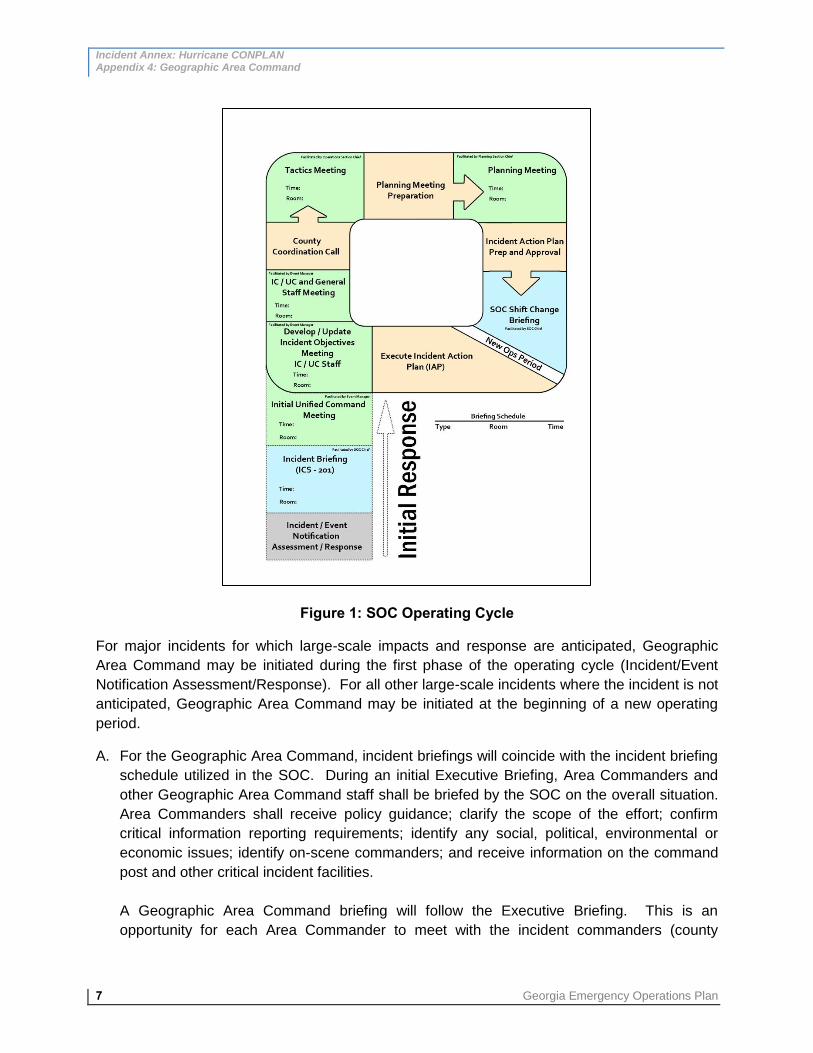
Incident Annex: Hurricane CONPLAN Appendix 4: Geographic Area Command
7 Georgia Emergency Operations Plan
Figure 1: SOC Operating Cycle
For major incidents for which large-scale impacts and response are anticipated, Geographic
Area Command may be initiated during the first phase of the operating cycle (Incident/Event
Notification Assessment/Response). For all other large-scale incidents where the incident is not
anticipated, Geographic Area Command may be initiated at the beginning of a new operating
period.
A. For the Geographic Area Command, incident briefings will coincide with the incident briefing
schedule utilized in the SOC. During an initial Executive Briefing, Area Commanders and
other Geographic Area Command staff shall be briefed by the SOC on the overall situation.
Area Commanders shall receive policy guidance; clarify the scope of the effort; confirm
critical information reporting requirements; identify any social, political, environmental or
economic issues; identify on-scene commanders; and receive information on the command
post and other critical incident facilities.
A Geographic Area Command briefing will follow the Executive Briefing. This is an
opportunity for each Area Commander to meet with the incident commanders (county
Incident Annex: Hurricane CONPLAN Appendix 4: Geographic Area Command
Georgia Emergency Operations Plan 8
emergency managers) that fall within his or her Geographic Area Command. The
Geographic Area Command Briefing will have a structure similar to the Executive Briefing;
the Area Commander and incident commanders will clarify the scope of the effort; confirm
communication protocols; identify any social, political, environmental, or economic issues;
and relay information on the command post and other critical incident facilities.
B. During the phase “Develop/Update Incident Objectives Meeting – IC/UC Staff” in the SOC
(see Figure 1), based on feedback received in the Geographic Area Commander briefing,
each Area Commander will develop and submit to the SOC overall incident objectives. The
incident objectives from each Geographic Area Command will be compiled into the incident
objectives for the State. During the following IC/UC and General Staff Meeting (see Figure
1), the command and general staff will have an opportunity to discuss the submitted incident
objectives with each Area Commander as necessary.
C. Prior to the County Coordination Call (see Figure 1), each Area Commander will convene
once more with his or her incident commanders to discuss potential strategies to achieve
the established incident objectives. Area Commanders, with the assistance of the Area
Command Logistics Chief, will also identify what resources are needed, and the availability
and status of these resources within the Area Command. During the County Coordination
Call, the SOC will discuss with each Area Commander the strategies that will be employed
to achieve each area’s incident objectives. Any resource needs will be discussed; these will
either be met by a neighboring Geographic Area Command or submitted to the SOC as a
Request for Assistance (RFA). The feedback received during the County Coordination Call
will be used by each Area Commander to finalize tactical strategies to achieve objectives;
assign resources to implement the tactics; and identify methods for monitoring tactics and
resources. These will be presented in the Tactics Meeting (see Figure 1).
D. As operations progress within each Geographic Area Command, the Area Command
Planning Chief will gather information for inclusion in the statewide Incident Action Plan
(IAP). (This takes place during “Planning Meeting Preparation” in the SOC’s operating
cycle.) He or she will draw from the following sources during the information-gathering
process: deliverables from the Tactics Meeting, such as ICS Form 215 and 215a; an
assessment of the effectiveness of current operations and resource efficiency; and other
pertinent information that may be used to support incident management decisions. During
the Planning Meeting (see Figure 1), the SOC will convene once more with the Geographic
Area Commanders to review and validate the operational plan. The SOC Planning Chief will
use the feedback from this meeting to prepare the IAP for approval.
E. During the Operations Period Briefing (see Figure 1), the SOC will present the approved IAP
to Geographic Area Commanders to brief them on current operations and discuss any
possible changes in strategy. This phase typically signals the end of the operating period.
F. During operations, as the IAP approved during the previous operating period is executed,
the Geographic Area Command staff and SOC will monitor the progress and status of

Incident Annex: Hurricane CONPLAN Appendix 4: Geographic Area Command
9 Georgia Emergency Operations Plan
activities on an ongoing basis to ensure incident objectives are being successfully met. It is
the Area Commander’s responsibility to keep the SOC informed of progress and issues;
resolve issues as they occur; follow-up with Geographic Area Command personnel on work
assignments and open actions; attend pertinent meetings and briefings scheduled by the
SOC (via conference call or other virtual means); evaluate staff effectiveness and order
additional resources as needed; and provide clarification, guidance, and leadership for the
Geographic Area Command unit. Likewise, the SOC has the responsibility to remain
transparent and accessible to the Area Commander and Geographic Area Command
personnel; provide State resources as available; serve as a liaison between the Geographic
Area Command and State and federal government entities; and provide guidance,
leadership, and support to assist the Geographic Area Command in successfully meeting its
objectives and supporting the needs of the impacted counties.