
Geophysical Investigation: Elkton Landfill Elkton, Virginia Investigation Elkton Landfill...
12
Geophysical Investigation: Elkton Landfill Elkton, Virginia for Ecosystem Services 1739 Allied Street Suite A Charlottesville, Virginia 22902 prepared by HydroGeo Environmental, LLC 418 East Main Street Charlottesville, Virginia 22902 HydroGeo Project #17-281 Issued: August 31, 2017 Kathryn Bryant Geologist Ernest Beasley, MS, CPG Geologist
Transcript of Geophysical Investigation: Elkton Landfill Elkton, Virginia Investigation Elkton Landfill...

Geophysical Investigation:
Elkton Landfill
Elkton, Virginia
for
Ecosystem Services
1739 Allied Street Suite A
Charlottesville, Virginia 22902
prepared by
HydroGeo Environmental, LLC
418 East Main Street
Charlottesville, Virginia 22902
HydroGeo Project #17-281
Issued: August 31, 2017
Kathryn Bryant
Geologist
Ernest Beasley, MS, CPG
Geologist

Geophysical Investigation: Elkton Landfill HydroGeo Project #17-281 Elkton, Virginia August 31, 2017
1
TABLE OF CONTENTS
1.0 INTRODUCTION ..................................................................................................................................... 2
1.1 Background and Project Objectives ...................................................................................................... 2
1.2 Site Description ..................................................................................................................................... 2
2.0 INSTRUMENTATION .............................................................................................................................. 3
2.1 Geonics EM31 and EM38 (Electromagnetic Induction) ........................................................................ 3
2.2 GPS ......................................................................................................................................................... 4
3.0 METHODOLOGY ..................................................................................................................................... 4
3.1 Survey Activities .................................................................................................................................... 4
3.2 Data Processing ..................................................................................................................................... 4
4.0 RESULTS ................................................................................................................................................. 5
4.1 Discussion: Primary AOI ........................................................................................................................ 6
FIGURES Figure 1: Site Layout
Figure 2: EM31 survey transect in progress
Figure 3: Overlaying various EM datasets in GIS software facilitated interpretation of the extent of fill
material at the Site
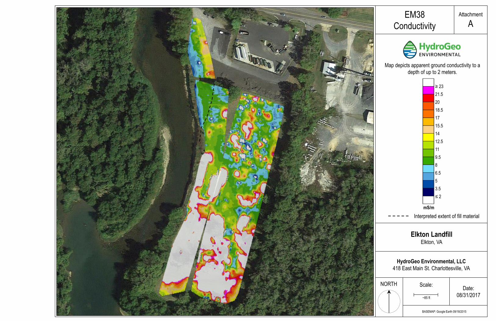
ATTACHMENTS Attachment A: EM38 Conductivity
Attachemnt B: EM38 In-Phase
Attachment C: EM31 Conductivity
Attachment D: EM31 In-Phase
Attachment E: Shaded Relief Map
ELECTRONIC FILES
Elkton Landfill Contoured EM Datasets
LiDAR – Shaded Relief Map

Geophysical Investigation: Elkton Landfill HydroGeo Project #17-281 Elkton, Virginia August 31, 2017
2
1.0 INTRODUCTION
1.1 Background and Project Objectives
On August 16th and 17th, 2017, HydroGeo Environmental, LLC conducted geophysical investigations at a historic landfill site located along the eastern bank of the South Fork of the Shenandoah River in Elkton, Virginia. The equipment used for these investigations included the Geonics EM31 and EM38 terrain conductivity meters. The purpose of the investigation was to aid in delineating the horizontal limits of fill material at the landfill site. The results of this work will be used to help identify the extent of the landfill and to assist in planning excavation activities related to a riverbank stabilization project, led by Ecosystem Services. Although all accessible areas of the Site were mapped for this work, the primary area of interest (AOI) for this project includes the land along the east bank of the Shenandoah River beginning where fill material is currently exposed (“trash” illustrated in Figure 1), and extending northward to the mature trees located just west of the parking area.
Figure 1: Site Layout
1.2 Site Description
The historic landfill site comprises approximately 8 acres and reportedly lacks detailed documentation regarding the contents and extent of fill material underlying the property. Much of the Site is open field, surrounded by wooded areas to the south and east. The Property is bordered by the Shenandoah River to the west and Old Spotswood Trail to the north. A paved parking area and refuse transfer station
0 180 360 feet
Berm
Parking

Geophysical Investigation: Elkton Landfill HydroGeo Project #17-281 Elkton, Virginia August 31, 2017
3
occupies the northern area of the Site. The confluence of Elk Run and the Shenandoah River is located just to the south of the Site. Native soils onsite are mapped by the Natural Resources Conservation Service (NRCS) as the Millrock loamy sand, which formed in alluvium derived from sedimentary rocks. The Millrock soil is reportedly well-drained with rapid permeability.
2.0 INSTRUMENTATION
The equipment selected for this investigation included the Geonics EM31 and EM38 terrain conductivity meters. Navigation and positioning were accomplished through the use of a Juniper Systems Geode Differential GPS (DGPS) antenna.
2.1 Geonics EM31 and EM38 (Electromagnetic Induction)
Both instruments consist of boom-mounted coplanar electromagnetic transmitter and receiver coils that are mounted at a fixed distance. The distance between the coils affects depth of signal penetration into the subsurface. The EM31 coil spacing is 4 meters and the EM38 coil spacing is 1 meter, providing maximum investigation depths of 6- and 2-meters, respectively. Both the EM31 and EM38 ground conductivity meters were utilized for this work to provide multiple depths of investigation, as little was known about the nature of the fill prior to this work. Data are collected and stored in a digital data recorder attached to the instrument during surveys. A current applied to the transmitter coil produces a time-varying magnetic field, which induces small secondary currents within the earth. These currents generate a secondary magnetic field, which is detected along with the primary field by the receiver coil. The instruments were carried at a consistent height throughout data collection and both were operated in the vertical dipole mode, where the greatest portion of the instrument response is affected by material in the 1- to 3- meter depth range for the EM31, and in the 0.5-meter range for the EM38.
Figure 2: EM31 survey transect in progress

Geophysical Investigation: Elkton Landfill HydroGeo Project #17-281 Elkton, Virginia August 31, 2017
4
Both the EM31 and EM38 simultaneously measure two components of the induced magnetic field. The first is the quadrature-phase component, which is a measurement of the apparent terrain conductivity in milliSiemens per meter (mS/m). Quadrature-phase data (commonly referred to as conductivity) is useful for delineating areas where terrain conductivity differs from local background levels. Variations in ground conductivity can be caused by subsurface features such as old roadbeds, foundations of former buildings, accumulations of buried metal, groundwater contaminant plumes, underground utilities, and shallow rock. Terrain conductivity is a function of clay content, porosity, the ionic strength of soil moisture, degree of saturation, and other properties of subsurface material. The ability to detect subtle lateral changes in terrain conductivity makes EM data very useful in mapping the subsurface conditions across a site.
The second component measured is the in-phase, which is a measurement of the ratio between the induced magnetic field and the earth’s magnetic field expressed in parts per thousand (ppt). The in-phase component is sensitive to metallic objects and is thus often used for the detection of buried metallic waste. It should be noted that, depending on scale, an instrument’s coil separation can inhibit the ability of the in-phase component to locate discreet metallic objects or small concentrations of metal.
2.2 GPS
An external, handheld Juniper Systems Geode DGPS antenna was used to log geographic coordinates throughout the surveys. The Geode receives real-time GPS corrections from GNSS satellites during operation, allowing for sub-meter accuracy on the go. Positional data was sent to the data loggers via Bluetooth at a rate of one reading per second.
3.0 METHODOLOGY
3.1 Survey Activities
On August 16th and 17th, 2017, parallel transects of varying length and azimuth orientation were mapped with both instruments at the Site. Transect lines were predetermined in the field; prior to data collection, HydroGeo staked out survey grids to guide field workers during surveys. Transects were spaced 15 feet apart in most cases. HydroGeo ran surveys with transects oriented both North-South and East-West to ensure complete coverage of the survey area and in attempt to detect any subsurface geophysical anomalies influenced by transect orientation.
Both instruments collected geophysical data at a rate of 5 readings per second. The data were initially stored in the instruments’ data loggers and transferred to a laptop computer for preliminary reviews and data validation in the field. Data were then submitted to HydroGeo's Charlottesville, Virginia office for advanced processing and final map production.
HydroGeo is working with Underhill Engineering to determine proposed borehole locations to ground truth the EM data. HydroGeo also collected GPS points of important site features (exposed trash in the streambank, metal fences, etc.) during field activities to inform our interpretations of the geophysical data.
3.2 Data Processing
The geophysical data were temporarily stored in the instruments’ dataloggers and then downloaded onto a laptop computer for quick on-site review to validate the quality of the data. Once in-field data review was complete, the data were transferred to HydroGeo’s Charlottesville, Virginia office for advanced processing.
Using Geonics DAT31 and DAT38 software, datafiles were converted to allow for inclusion of GPS positioning. Surfer by Golden Software was used to generate contour and classified post maps for each data set. Final contoured EM datasets were exported to GIS software for the production of final maps.
Geophysical Investigation: Elkton Landfill HydroGeo Project #17-281 Elkton, Virginia August 31, 2017
5
Geophysical data processing included the following steps:
Conversion of raw files to include GPS coordinates;
Verification of GPS quality, data density, and non-intersecting line paths;
De-spiking: removing any erroneous data spikes in the magnetics data (if necessary);
Digital filtering (if necessary) and gridding of data;
Contouring and manipulation of color displays;
Preparation of geophysical maps and interpretation.
4.0 RESULTS
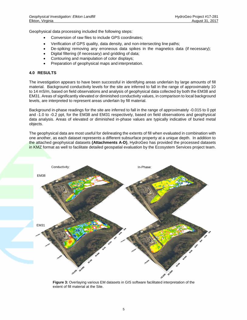
The investigation appears to have been successful in identifying areas underlain by large amounts of fill material. Background conductivity levels for the site are inferred to fall in the range of approximately 10 to 14 mS/m, based on field observations and analysis of geophysical data collected by both the EM38 and EM31. Areas of significantly elevated or diminished conductivity values, in comparison to local background levels, are interpreted to represent areas underlain by fill material. Background in-phase readings for the site are inferred to fall in the range of approximately -0.015 to 0 ppt and -1.0 to -0.2 ppt, for the EM38 and EM31 respectively, based on field observations and geophysical data analysis. Areas of elevated or diminished in-phase values are typically indicative of buried metal objects. The geophysical data are most useful for delineating the extents of fill when evaluated in combination with one another, as each dataset represents a different subsurface property at a unique depth. In addition to the attached geophysical datasets (Attachments A-D), HydroGeo has provided the processed datasets in KMZ format as well to facilitate detailed geospatial evaluation by the Ecosystem Services project team.
Figure 3: Overlaying various EM datasets in GIS software facilitated interpretation of the
extent of fill material at the Site.
EM38
EM31

Geophysical Investigation: Elkton Landfill HydroGeo Project #17-281 Elkton, Virginia August 31, 2017
6
4.1 Discussion: Primary AOI
The EM data suggest that the fill material along the edge of the Shenandoah River continues beyond the exposed trash visible on the stream bank at least 70-80 feet to the north – likely farther. The man-made berm along the river at that location may mask important subsurface variability as its presence affected the depth of penetration of the EM signals in that area during surveys. The berm is visible on the shaded relief map created using publically available LiDAR data – Attachment E. An isolated anomaly, which most likely represents buried metal, is observed approximately 80 feet to the north of the clearly imaged extent of fill (38.408101°,-78.634757°) on Attachment D – this anomaly is located approximately 30 feet from the edge of the river. The geometry of its location in relation to other fill identified nearby suggests that the southern end of the berm did inhibit detection of fill material. See Attachments A-D for an interpreted fill boundary based on available data. A follow-up borehole investigation in this area is necessary to ground-truth the EM data and constrain our interpretation regarding the location of the limits of fill.
HydroGeo Environmental, LLC
418 East Main St. Charlottesville, VA
Scale:NORTH
Attachment
A
Elkton LandfillElkton, VA
Date:
08/31/2017
BASEMAP: Google Earth 09/18/2015
EM38
Conductivity
~85 ft
Map depicts apparent ground conductivity to a
depth of up to 2 meters.
Interpreted extent of fill material
≥ 23
21.5
20
18.5
17
15.5
14
12.5
11
9.5
8
6.5
5
3.5
≤ 2
mS/m

HydroGeo Environmental, LLC
418 East Main St. Charlottesville, VA
Scale:
Attachment
BEM38
In-Phase
Elkton LandfillElkton, VA
Date:
08/31/2017
BASEMAP: Google Earth 09/18/2015
NORTH
~85 ft
Map depicts location of inferred metal objects
to a depth of up to 2 meters.
Interpreted extent of fill material
≥ 0.025
0.02
0.015
0.01
0.005
0
-0.005
-0.01
-0.015
-0.02
-0.025
-0.03
-0.035
-0.04
≤ -0.045
mS/m

HydroGeo Environmental, LLC
418 East Main St. Charlottesville, VA
Scale:
Attachment
C
Elkton LandfillElkton, VA
Date:
08/31/2017
BASEMAP: Google Earth 09/18/2015
NORTH
EM31
Conductivity
~85 ft
Map depicts apparent ground conductivity to a
depth of up to 6 meters.
Interpreted extent of fill material
≥ 22
21
20
19
18
17
16
15
14
13
12
11
10
9
≤ 8
mS/m

HydroGeo Environmental, LLC
418 East Main St. Charlottesville, VA
Scale:
Attachment
D
Elkton LandfillElkton, VA
Date:
08/31/2017
BASEMAP: Google Earth 09/18/2015
~85 ft
NORTH
EM31
In-Phase
Interpreted extent of fill material
Map depicts location of inferred metal objects
to a depth of up to 6 meters.
≥ 0.8
0.6
0.4
0.2
0
-0.2
-0.4
-0.6
-0.8
-1.0
-1.2
-1.4
-1.6
-1.8
≤ -2.0
mS/m

HydroGeo Environmental, LLC
418 East Main St. Charlottesville, VA
Scale:
Attachment
EShaded Relief Map
Elkton LandfillElkton, VA
Date:
08/31/2017
BASEMAP: Google Earth 09/18/2015
ELEVATION DATA: Chesapeake Bay LiDAR Project - 2015
~110 ft
NORTH
Transfer Station


![[XLS] · Web viewElizabeth Page Elem 1300 Hayden Bridge Rd 541-744-6407 Elk Meadow Elem 60880 Brookswood Blvd 541-383-6420 Elkton Charter School Elkton Elkton SD 34 Elmira Elem 88960](https://static.fdocuments.in/doc/165x107/5b04a9e17f8b9a8c688e099c/xls-viewelizabeth-page-elem-1300-hayden-bridge-rd-541-744-6407-elk-meadow-elem.jpg)


