Geophysical Changes of Wetland Resources and their...
14
Transactions | Vol. 39, No. 2, 2017 | 223 Trans.Inst.Indian Geographers ISSN 0970-9851 Geophysical Changes of Wetland Resources and their Management in Nonoi Watershed, Assam Labanya Das and A.K. Bora, Guwahati, Assam Abstract The Nonoi watershed, which spans over some plain areas of Nagaon district and hilly areas of Karbi Anglong district of Assam has a total wetland area of 12.01 sq km accounting for 2.2 % of the total watershed area. The secondary data and also the primary data collected through fieldworks reveal that the more than 80% of the wetlands are genetically associated with the river Nonoi and its tributaries. Due to effects of growing human activities in and around the wetland areas, some geophysical changes are taking place in the wetland ecosystem. This paper attempts to analyse the changes of the wetlands in terms of their morphology, hydrology and above all biodiversity and their management issues. Moreover, some suggestions for wetland resources conservation along with the fixing of conservation priorities to the wetland environment have been incorporated in the study. Key Words: Wetlands, Morphology, Biodiversity, Hydrology, Conservation priorities. Introduction The presence of wetlands in geo-physical environment has made a vital link between terrestrial and aquatic landscapes which comprise about 6% of the world’s surface. The wetlands may be described as ‘Kidneys’ of the biosphere as they influence upon the flow of nutrients in ecosystem (Mitsch & Gosselink, 1986). The transitional nature of wetlands enriches the surrounding environment and biodiversity itself in association with human interference. The International Union for the Conservation of Nature and Natural Resources (IUCN) modified the definition of wetland as “All submerged or water saturated lands, natural or man- made, inland or costal, permanent or temporary, static or dynamic, vegetated or non-vegetated, which necessarily have a land water interface are called wetlands”. On the other hand, the first world Convention on Wetlands held on 2 nd February 1971 at Ramsar in Iran defined wetlands as “Areas of marsh, fen, peat land or water bodies whether natural or artificial, permanent or temporary with water that is static or flowing, fresh, brackish or salt including areas of marine water; the depth of which at low tide, does not exceed 6 meters”. The landscapes of wetlands have been focused in terms of their importance in various disciplines. In North-East India, Assam is endowed with abundant water bodies and swampy landscape, which are recorded in 2003 as the total number of wetlands being 1344 covering 86355
Transcript of Geophysical Changes of Wetland Resources and their...
Transactions | Vol. 39, No. 2, 2017 | 223
Trans.Inst.Indian GeographersISSN 0970-9851
Geophysical Changes of Wetland Resources and their Management in Nonoi Watershed, Assam
Labanya Das and A.K. Bora, Guwahati, Assam
AbstractThe Nonoi watershed, which spans over some plain areas of Nagaon district and hilly areas of Karbi Anglong district of Assam has a total wetland area of 12.01 sq km accounting for 2.2 % of the total watershed area. The secondary data and also the primary data collected through fieldworks reveal that the more than 80% of the wetlands are genetically associated with the river Nonoi and its tributaries. Due to effects of growing human activities in and around the wetland areas, some geophysical changes are taking place in the wetland ecosystem. This paper attempts to analyse the changes of the wetlands in terms of their morphology, hydrology and above all biodiversity and their management issues. Moreover, some suggestions for wetland resources conservation along with the fixing of conservation priorities to the wetland environment have been incorporated in the study.
Key Words: Wetlands, Morphology, Biodiversity, Hydrology, Conservation priorities.
Introduction
The presence of wetlands in geo-physical environment has made a vital link between terrestrial and aquatic landscapes which comprise about 6% of the world’s surface. The wetlands may be described as ‘Kidneys’ of the biosphere as they influence upon the flow of nutrients in ecosystem (Mitsch & Gosselink, 1986). The transitional nature of wetlands enriches the surrounding environment and biodiversity itself in association with human interference. The International Union for the Conservation of Nature and Natural Resources (IUCN) modified the definition of wetland as “All submerged or water saturated lands, natural or man- made, inland or costal, permanent or temporary, static or dynamic, vegetated
or non-vegetated, which necessarily have a land water interface are called wetlands”. On the other hand, the first world Convention on Wetlands held on 2nd February 1971 at Ramsar in Iran defined wetlands as “Areas of marsh, fen, peat land or water bodies whether natural or artificial, permanent or temporary with water that is static or flowing, fresh, brackish or salt including areas of marine water; the depth of which at low tide, does not exceed 6 meters”.
The landscapes of wetlands have been focused in terms of their importance in various disciplines. In North-East India, Assam is endowed with abundant water bodies and swampy landscape, which are recorded in 2003 as the total number of wetlands being 1344 covering 86355

224 | Transactions | Vol. 39, No. 2, 2017
hectare area as against 2167 number of wetlands covering 1450861 hectare area in India (Parikh, 2003).These water bodies and swampy landscapes in riverine area are the creation of the two river systems, the Brahmaputa and the Barak. In local term the water bodies are known as ‘beel’ and in some area beels are named as ‘gadeng’. On the other hand, the marshes and swamps are generally known as ‘jalah’, ‘pitoni’, ‘doloni’, ‘doba’ and ‘hola’ etc.(Sharma,1993, Sahariah, 2007). In true sense, universally all these natural features may be included in the term ‘wetland’ and these may be categorized into two forms, one is beel which is the lake-like features with clear water spread area in the middle, while another is swamps or marshes covered by weeds, grasses etc. The significance of wetland lies with geomorphological, biological and socio- economical value in an area. But, these wetlands are under threat from drainage problem, conversion for agriculture and human settlement besides pollution (National Environment Policy, 2006). The most productive and resourceful wetlands of Assam are going to change due to natural and human activities. The present study is emphasizing on the study of geophysical changes of wetlands in the Nonoi watershed.
Study Area
The study area is confined to the Nonoi watershed which is drained by the river Nonoi and its tributaries. The Nonoi Watershed covering an area of 55296.68 ha is located in south-eastern part of Nagaon district and also some parts of Diphu subdivision of Karbi Anglong district of Assam. About 78.47% of the watershed area of Nonoi basin falls in Nagaon district, while about 21.53% of its area falls in Karbi Anglong district. The watershed lies between 26º 11’ N and 26º 26’N latitude and 92º 35’ E and 93º 3’ E longitude. This river Nonoi has its wider floodplain in the lower part with some wetlands like Sukatiputa beel, Borphakuli beel, Achila beel, Bogi doba, Sapekhati beel, hahila beel, chalchali jalah, Mohgar jalah and Afutali beel etc.
Physiographically, the area consists of plain and plateau regions with height varying from 60 m to 530 m. The famous waterfall Champawati Kunda is located in the Chapanalla area of the watershed, which is an important tourist place of Nagaon district. The Nonoi watershed enjoys average annual rainfall of 175 cm and annual average temperature range from 19.8º c to 30.4º c. The soils of the study area are made of old alluvial and red soil. Red soils are present on the slopes of the south-eastern part of Karbi Plateau.

Transactions | Vol. 39, No. 2, 2017 | 225
Objectives
The main objectives of the study are -
1) To study about the types, distribution and origin of wetlands.
2) To analyse the morphological and hydrological characteristics of the wetlands and their changes.
3) To suggest strategies for conservation and management of the wetlands.
Fig 1 : Location of Nonoi Watershed, Assam
226 | Transactions | Vol. 39, No. 2, 2017
Data Base and Methodology
Both primary and secondary data are used in the entire work. The secondary data have been obtained from the reports published by the Census of India, district statistical hand books, Govt. of Assam, records from the State Revenue Department, District Fishery Departments, different development blocks, books and journals of various wetland related issues, published and unpublished works and websites etc. Primary data are collected from the field survey using designed questionnaires or survey schedules. In order to collect the data and information a comprehensive field survey have been conducted with 334 households and respondents from 8 selected villages [Fig.5]. Accordingly oral discussions with some experienced and elder persons of the villages located near the wetlands were held for collection of information on use of water bodies and their change pattern.
Wetlands in the study area are initially identified and a map showing wetlands has been prepared based on Survey of India topographical map 83 B/11, 83B/12, 83B/15, 83B/16and 83F/3 at 1:50,000 scale (1971) and visual interpretation technique has been employed to identify the wetlands of 2008 [Fig. 3]. Changes of shape and size and area of the wetlands are detected with the help of LISS III NRSC map (2008), remote sensing and GIS (Geographic Information System) (ArcGIS-9.3) technique using Arc GIS-9.3.
Results and Discussion
Distribution of Wetlands
Wetlands of the Nonoi watershed are distributed mostly in lower part of the watershed having low elevation (50-60m).Within the geographical boundary of the study area 12 beels and 45 swamps have been identified. The total area of the beels is 500.66 hectares and swamps is 662.84 hectares (as per 1971 toposheet data) covering 20.9 % of the total geographical area of the watershed. The distribution of beels and swamps is confined to the flat alluvial riverine plains of Nonoi watershed. The beels are connected with small streams or feeder channel locally called ‘jan’ and they represent a riverine landscape in the lower part of the river. The landscapes of Sapekhati, Achalia, Tindighali, Barphakali, Udmari, and Hahila wetlands are known as ‘Jamunarjalah’, i.e. the jalah or wetland of the Jamuna river, a tributary of Kapili river system. More than 90% of the beels and 80% of the swamps (locally known as jalah or doloni) are associated with Nonoi river and Tulsi tributary.
The wetlands possess good amount of aquatic plants and fish which enhance source of income and support the livelihood pattern among the village people. Almost 80% of rural people have engaged themselves with the nearby wetlands, especially for agricultural activity, fishing and grazing of animals. Some sample villages Bhelaigaon, Chachali Jalah gaon, Pamgaon, Deorigaon, Ranthali, Jalahgaon, Rangalumukh, and Sukatiputa gaon. These villages are dominated with the communities like Non-Tribe, Scheduled Caste, and Muslim people.
Transactions | Vol. 39, No. 2, 2017 | 227
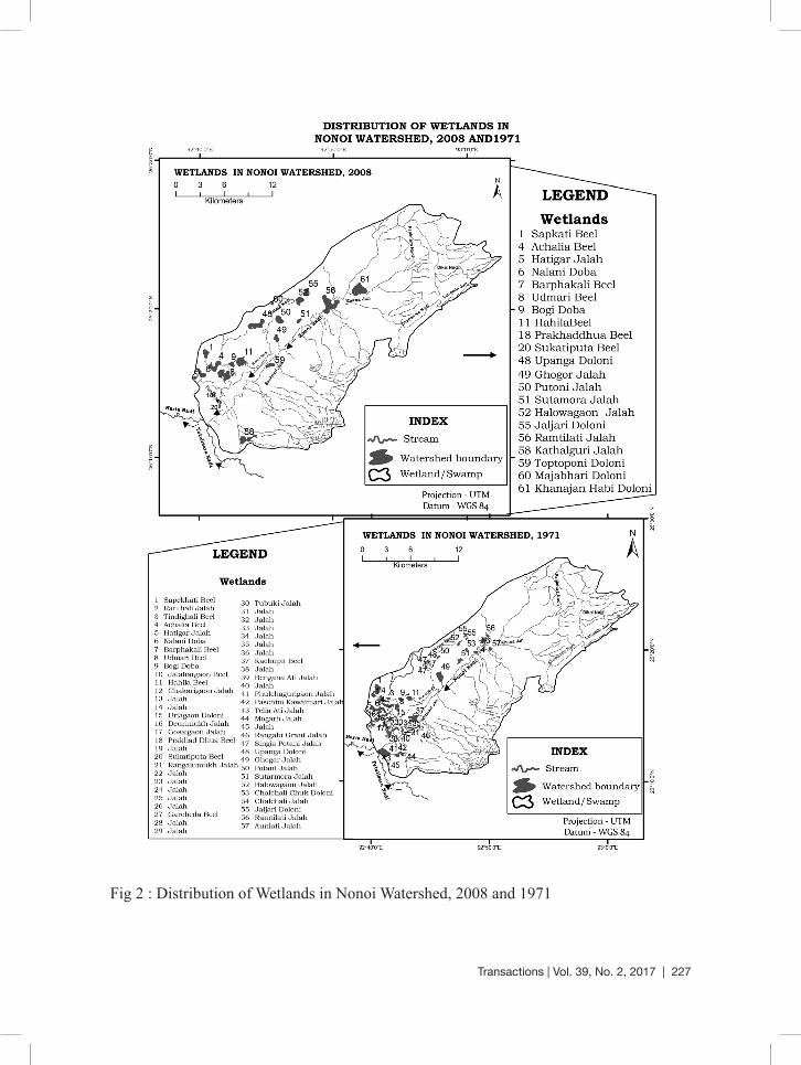
Fig 2 : Distribution of Wetlands in Nonoi Watershed, 2008 and 1971

228 | Transactions | Vol. 39, No. 2, 2017
The distribution of wetlands is shown in figure 2 and 3. The wetland distribution maps depict the pattern of changes developed from 1971 to 2008. In order to identify the morphological change of wetlands over the watershed, the map of 2008 is used as base map [Fig. 2 and Table 4].
Wetland types and origin
The types of wetlands in the study area include beels or lake- like water bodies and ‘Jalah’, ‘Doloni’, ‘Doba’ as known in
local term, which are universally known as ‘swamps’ or ‘marshes’. As regards to the 1971 topographical map, there are 12 beels covering an area of 500.66 hectares out of 1163.5 hectare and swamps of 45 numbers occupying 662.84 ha of area.
Generally, the types of the beels are observed in two forms, one is seasonal and another is perennial. Both types of beels are found in Nonoi watershed. Some wetlands are seasonal and shallow floodplain wetlands, which seasonally get over flooded during monsoon rain.
Table 1 : Status of wetlands in the Nonoi Watershed, 2012
Type of Wetlands NumberPercentage of the total
number
Area (in Ha)
Percentage of the total
wetland area
No. Of villages
associated with
wetlands
Percentage of the total number of
villages associated
with wetlands
Natural wetlands (Beel) 8 0.3 242.41 16.6 10 4.5Marshes (Pitoni, Jalah) 3 0.1 168.9 11.6 7 3.15Water Logging (Duba, Hola) 11 0.4 767.88 52.7 56 25.23Canal(Jan, Khawai) 12 0.44 35.9 2.5 16 7.21Man made Pond (Pukhuri) (Private use) 2518 92.34 184.198 12.63 186 83.7Man made Pond (Pukhuri) (Public use) 175 6.42 58.06 3.98 186 83.7Total 2727 100 1457.35 100 222
Source: Field Survey-2012-2013 and Department of Fishery, Nagaon District
The origin of wetlands in the area is associated with the origin of floodplains. The formation of the floodplain wetlands are the result of geological and lithological formation, tectonic status, pattern of channel
migration, and variation of river water discharge and flow characteristics. Moreover, origin of wetlands and their transformation mostly depend upon geophysical processes as well as geo-environmental changes

Transactions | Vol. 39, No. 2, 2017 | 229
including human interference. The study of the wetlands in Nonoi basin reveals that the wetlands are of riverine origin and of specific-location origin. It is found that
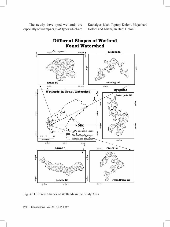
some beels and swamps are linear or ox-bow shaped and others are compact, discrete and irregular shaped.
Table 2 : Types and change pattern of wetlands in the Nonoi watershed, 1971-2008
Types of WetlandsNumber of Wetlands Area (in Ha)
1971 2008 Change in % 1971 2008 Change in %
Natural Wetland (Beel) 12 8 -33.33 500.66 242.4 -51.58
Swamps and Marshes (Jalah or Doloni or Doba) 45 14 -68.89 662.84 959 44.68
Morphological characteristics of wetlands
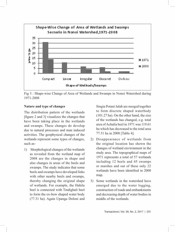
The morphological characteristics of the wetlands mainly include the shape, size and area extent of the wetlands. The shape of the wetlands is determined by various factors such as geology, location, process of formation and degradation, development stage, nature of feeder channels and human interference. The configuration of the wetlands of the watershed can be divided into five categories, viz. linear, compact, discrete, irregular and ox-bow shaped [Table 3 and 4]. The compact types of wetlands are mostly identified in the study area in 1971 topographical map. As many as 31 numbers out of 57 numbers of wetlands covering the area of 672.26 ha are compact
shaped as because they are differentiated from other category on the basis of length and breadth ratio. These compact-shaped wetlands are Hahila beel, Udmari beel, Sapekhati beel, Tindigholi beel, Kachupit beel, sapekhati jalah, Bogi Doba, Ghogar jalah, Chalchali jalah, Auniati jalah etc. On the other hand, the generated data of 2008 show the 14 numbers of compact shaped wetlands which cover 605.69 ha area of the watershed [Fig. 3].
The size of the wetlands varies from small, medium and large according to their area. The wetlands may be categorised as small having less than 50 ha as medium size having area between 50-100 ha and large and as large size having area above 100 ha.
230 | Transactions | Vol. 39, No. 2, 2017
Hydrology and water regime
Hydrology is one of the key attributes of wetland environment (Ministry of Environment & Forest, 2007). Wetlands are the areas where water is the primary factor controlling the environment and the associated plant and animal life. The wetlands of the study area receive their water from the river Nonoi, Tulsi(sub-tributaries of the Brahmaputra and Kolang-Kapili river). The wetlands are also linked by the small streams or feeder channel (locally called Jan), viz. Salmari Jan, Bar Jan, Pathari Jan, Bar Pathari Jan, Moukhiti Jan and Khana Jan. The length of these feeder channels varies from a few meters to more than 5 kms. The geological background of the wetland sediments comprises the Quaternary group of sediments of unconsolidated alluvium along with predominance of sand, silt and clay. The field observation reveals that
wetlands get inundated during the heavy rainfall season or monsoon season and on the contrary, they are dried up generally during the period of post monsoon. Depth of the wetlands varies from 15 ft to 20 ft in summer season and the surrounding areas are commonly over-flooded upto 2-4 ft in summer. Seasonal changes of the water body create the problem for biological resources causing effects on biodiversity.
However, the wetlands have some potential for irrigation and cultivation of land in a sustainable way. The hydrology of the wetlands has changed with the change of time and wetland environment. For example the Hahila beel which had 15 m depth in 1993 is presently having depth of 8-10 m in 2015. As a result of clay deposition, the percentage of clay has increased in the sediment composition in the bottom of the wetlands.
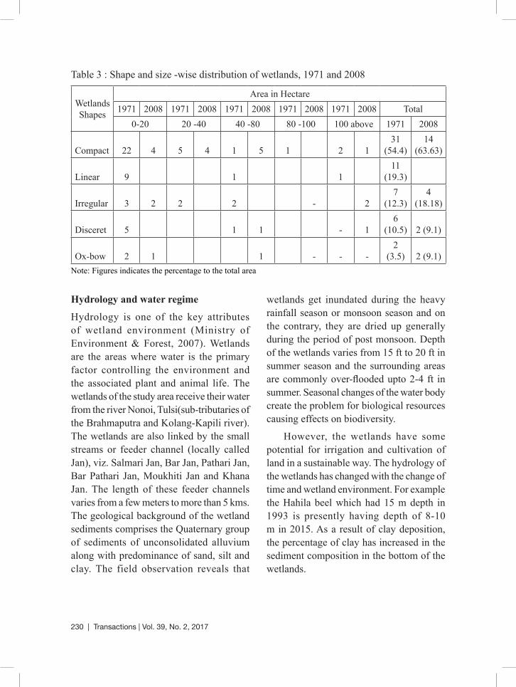
Table 3 : Shape and size -wise distribution of wetlands, 1971 and 2008
Wetlands Shapes
Area in Hectare1971 2008 1971 2008 1971 2008 1971 2008 1971 2008 Total
0-20 20 -40 40 -80 80 -100 100 above 1971 2008
Compact 22 4 5 4 1 5 1 2 131
(54.4)14
(63.63)
Linear 9 1 1 11
(19.3)
Irregular 3 2 2 2 - 27
(12.3)4
(18.18)
Disceret 5 1 1 - 16
(10.5) 2 (9.1)
Ox-bow 2 1 1 - - -2
(3.5) 2 (9.1)Note: Figures indicates the percentage to the total area
Transactions | Vol. 39, No. 2, 2017 | 231
Nature and type of changes
The distribution pattern of the wetlands [figure 2 and 3] visualizes the changes that have been taking place in the wetlands and swamps. These changes do develop due to natural processes and man induced activities. The geophysical changes of the wetlands represent some types of changes, such as-
1) Morphological changes of the wetlands as revealed from the wetland map of 2008 are the changes in shape and also changes in areas of the beels and swamps. The study indicates that some beels and swamps have developed links with other nearby beels and swamps, thereby changing the original shape of wetlands. For example, the Hahila beel is connected with Tindighali beel to form the ox-bow shaped water body (77.31 ha). Again Upanga Doloni and
Singia Potani Jalah are merged together to form discrete shaped waterbody (101.27 ha). On the other hand, the size of the wetlands has changed, e.g. total area of Achalia beel in 1971 was 119.61 ha which has decreased to the total area 77.31 ha in 2008 [Table 4].
2) Disappearance of wetlands from the original location has shown the changes of wetland environment in the study area. The topographical maps of 1971 represents a total of 57 wetlands including 12 beels and 45 swamps or marshes and out of these only 22 wetlands have been identified in 2008 map.
3) Some wetlands in the watershed have emerged due to the water logging, construction of roads and embankments and decreasing depth of water bodies in middle of the wetlands.
Fig 3 : Shape-wise Change of Area of Wetlands and Swamps in Nonoi Watershed during 1971-2008
232 | Transactions | Vol. 39, No. 2, 2017
The newly developed wetlands are especially of swamps or jalah types which are
Kathalguri jalah, Toptopi Doloni, Majabhari Doloni and Khanajan Habi Doloni.
Fig. 4 : Different Shapes of Wetlands in the Study Area

Transactions | Vol. 39, No. 2, 2017 | 233
Factors Affecting wetlands
Various factors are responsible for wetland changes which cause the decreases and increase in the number of beels and swamps in study area. These factors include (i) water logging in some areas due to flood, construction of embankments and road which have increased the areas of swamps.
(ii) disappearance of beels and swamps is the result of human interference, specially expansion of settlements and agricultural activities (iii) changing water quality of the wetlands has caused changes in biodiversity pattern of wetlands (iv) addition of large quantities of pollutants may be the cause of degradation of wetland ecology.
Table 5 : Human use of Natural Wetland Resources in Surveyed households, 2012-2013
Category of UseNo. of
Household involved
Percentage of
Household involved
Percentage of households using for domestic purpose
Percentage of households using for
commercial purpose
Consumptive Use
Fishing 264 79 _ _
Fodder 264 79 79 18
Edidible plant products 128 38 38 12
Cattle Feed (Plants& Water) 156 47 - 5
Livestock grazing 210 63 - -
Non-Consumptive
Use
Irrigation purpose 54 16 - -
Recreation 285 85 - -
Bathing and Washing 38 11 - -
Source: Field Survey, 2012-2013

234 | Transactions | Vol. 39, No. 2, 2017
Fig 5 : Location of surveyed villages and use of wetlands in study area
Table 6 : Fishing Practice in the Wetlands carried out by the Surveyed Villages
Sl. No. Name of Villages No. of households engaged in fishing
Percentage of the total households
1 Bhelai Gaon 25 81
2 Chalchali Jalah 9 82
3 Dewrigaon 46 79
4 Pamgaon 32 68
5 Rangolumukh 16 89
6 Rantholi 79 92
7 Sukatiputa 6 85
8 Jalahgaon 51 67
Source: Field Survey, 2012-2013

Transactions | Vol. 39, No. 2, 2017 | 235
Man-induced affect
Settlements of numerous population by the side of the wetlands mostly affect the wetlands environment. The threat to wetlands is especially from changing drainage system and conversion of wetland areas, agriculture and human settlements, besides pollution. Population characteristics of eight selected surveyed villages show that increasing pressure of population over the area associated with wetlands really affect the wetland environment. The population density near the wetlands varies from 238 to 695 persons per sq. km during the period from 2001 and 2011. Hence, the result of increasing population pressure is reflected in the use of wetland resources available in the wetland ecosystem [Table 5 and 6 and figure 5]. In the study it is observed that the wetland resources are used by the villagers in both consumptive and non-consumptive ways and it is revealed that more than 79% households use wetland resources in a consumptive way like fishing and fodder [Table 5]. Hence, many of the rural people are engaged in fishing practice not only for domestic consumption but also for commercial purpose. From the data generated from the field study, it is found that above 80 % households have been practising fishing in the surveyed villages, e.g. Ranthali(92 %), Rangalumukh (89%), Sukatiputa (85 %), and Chalchali Jalah (82%) [Table 6 and figure 5]. On the other hand, 85% households have involved in the non-consumptive use of wetlands especially for recreational purpose (wedding and other occasions). Besides, some human activities which were noticed during field visit are (i) Expansion of habitat site of the rural
people, (ii) Flood control measures and unmanaged engineering constructions, (iii) Clearance of weeds and other common aquatic plants, (iv) Indiscriminate fishing, (v) Lack of management and peoples’ participation for enriching the wetland environment, (vi) Destruction of vegetations on the banks of the wetlands and (vii) Excessive use of chemical fertilizers and pesticides in the agricultural activities practised by the nearby people in the nearby agricultural fields.
Conservation and managementWetlands are one of the most productive ecosystems which support the livelihood of millions of people. All including water and its associates like plants, animals, and different insects create a suitable landscape for the balance of the environmental norms. In the study it is found that fishing provides good support to rural poor. But, the aquatic resources are getting depleted since last one or two decades. So, the current conservation threats, especially anthropogenic in nature threat include (i) illegal settlements growing around the wetlands and improper land use for agriculture purpose, (ii) lack of effective management policy, (iii) conversion of wetlands into grazing areas and agricultural land.
Summary and conclusionThis study has identified the changes taking place in the wetlands and their surrounding environment. Wetlands which may be recognized as the biodiversity hotspot were rich in biodiversity before long time as because of less impact of man. Most of the beels and swamps are named after the name
236 | Transactions | Vol. 39, No. 2, 2017
of the species abundantly found in them. Extensive human activities and associated disturbances have created threat to the wetland ecosystems and declined the number of migratory birds coming to the wetlands. Field observation reveals that there is general decrease of water level and different ecological elements from the wetlands during winter season and as a result, some of the shallow wetlands get transformed into grazing land. The proper management may bring about the sustainability of entire wetland system of the watershed.
References• Bullard W. E. (1966). Effects of Land Use on
Water Resources. Journal (Water Pollution Control Federation), Vol. 38, No. 4, pp. 645-659
• Chatterjee, A. (2010).Quality and ecological Characteristics of Natural Wetlands: Murshidabad, Nadia and North 24 Pargana district of West Bengal. Indian Journal of landscape Systems and Ecological Studies, volume 33, 243-252
• Deka, D.R. and Sharma, P.(2012). Changing Wetland Environment Based on Water and Soil Quality Analysis of Selected Wetlands, Assam, India; Journal of environmental science and engineering ,228-235
• Deka, D.R. (2011). Geo-ecological Status and Economic Potentials of Wetlands in Demoria Region of Assam, India; Ph. D. Thesis, Gauhati University, Assam, 234
• Deka N. & Bhagabati, A.K.(2015).Wetlands in a Village Environment: A Case from Brahmaputra Floodplain, Assam; Journal Transactions, Institute of Indian Geographers ,Vol. 37, No. 1,35-45
• Ministry of Environment & Forests, Government of India (2007)
• Mitsch, W.I & Gosselink, I.G.(1986). Wetlands. Van Nestrand Reinhold, New York.
• National Wetland Atlas, Assam (2010)
• National Environment Policy (2006)
• Parikh, J. (ed.) (2003). Sustainable Management of wetlands. Sage Publication, New Delhi
• Saud, B.J., Chetia,M. et al (2012). Eco-hydrobiology with Special Amphasis on Ichthyofaunal Diversity of Urpod Wetland of Goalpara, Assam, India; International Journal of Plant, Animanl and Environment Sciences, 103-109.
• Sarma, S. K. & Saikia, M (2010). Utilization of Wetland Resources by the Rural People of Nagaon District, Assam. Indian Journal of Traditional Knowledge,Vol. I, 145-151.
• Sahariah, D. (2007). Wetlands of the Brahmaputra Floodplain in Darrang district, Assam: A Fluvio- Geomorphic study, Ph. D. Thesis, Gauhati University, Assam, India.
• Sharma, P.(1993). Geo- Environmental Study of Beels and Swamps in Nagaon and Morigaon District of Assam, Ph.D. Thesis,Gauhati Univers i ty, Assam,Ind ia , p . 219 .
• Sharma, P. and Goswami, D.C (1995). Geo-environmental Status of Selected Beels (Wetlands). Indian Geomorphology and Resource Management (Ed- S.R. Jog, Vol.-II,pp 237-46), Rawat Publications, New Delhi.
• http:// www.ramsar.org
Labanya DasResearch Scholar,
C/O Hari Das, Vill- Baidyatup, C.P.S. RoadP.O- Madhupur, District- Nagaon, Assam
A. K. BoraProfessor, Department of Geography
Gauhati UniversityJalikbari, Guwahati, Assam