GEOPHYS RPT FOR FALCONBRIDGE LTD ON GRID 95-05 MANN …
25
42A14SE0019 2.163O7 MANN 010 #.133 07 GEOPHYSICAL REPORT FOR FALCONBRIDGE LIMITED ON GRID 95-05 MANN BELT PROJECT l 8269 MANN TOWNSHIP PORCUPINE MINING DIVISION NORTHEASTERN ONTARIO ( Prepared by: Paul Nielsen Northwest Geophysics Ltd. DEC 3 F - ; :, Sf MINING MN0ti
Transcript of GEOPHYS RPT FOR FALCONBRIDGE LTD ON GRID 95-05 MANN …

42A14SE0019 2.163O7 MANN 010
#.133 07GEOPHYSICAL REPORT
FOR FALCONBRIDGE LIMITED
ONGRID 95-05
MANN BELT PROJECTl 8269
MANN TOWNSHIP PORCUPINE MINING DIVISION
NORTHEASTERN ONTARIO
(Prepared by: Paul NielsenNorthwest Geophysics Ltd.
DEC 3 F - ;:,Sf
MINING MN0ti
42A14SE0019 2.16307 MANN 01OC
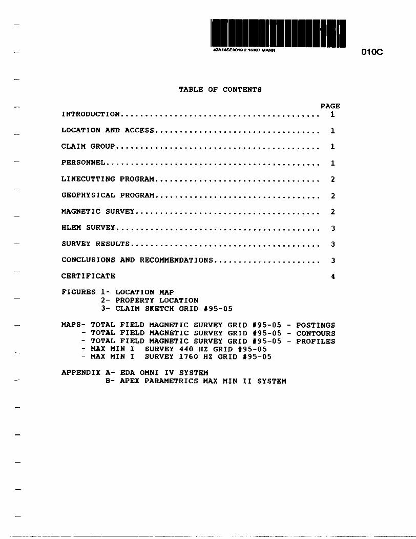
TABLE OF CONTENTS
PAGEINTRODUCTION. . . . . . . . . . . . . . . . . . . . . . . . . . . . . . . . . . . . . . . . . l
LOCATION AND ACCESS . . . . . . . . . . . . . . . . . . . . . . . . . . . . . . . . . . l
CLAIM GROUP . . . . . . . . . . . . . . . . . . . . . . . . . . . . . . . . . . . . . . . . . . l
PERSONNEL . . . . . . . . . . . . . . . . . . . . . . . . . . . . . . . . . . . . . . . . . . . . l
LINECUTTING PROGRAM. . . . . . . . . . . . . . . . . . . . . . . . . . . . . . . . . . 2
GEOPHYSICAL PROGRAM. . . . . . . . . . . . . . . . . . . . . . . . . . . . . . . . . . 2
MAGNETIC SURVEY . . . . . . . . . . . . . . . . . . . . . . . . . . . . . . . . . . . . . . 2
HLEM SURVEY . . . . . . . . . . . . . . . . . . . . . . . . . . . . . . . . . . . . . . . . . . 3
SURVEY RESULTS . . . . . . . . . . . . . . . . . . . . . . . . . . . . . . . . . . . . . . . 3
CONCLUSIONS AND RECOMMENDATIONS . . . . . . . . . . . . . . . . . . . . . . 3
CERTIFICATE 4
FIGURES l- LOCATION MAP2- PROPERTY LOCATION3- CLAIM SKETCH GRID 195-05
MAPS- TOTAL FIELD MAGNETIC SURVEY GRID 195-05 - POSTINGS- TOTAL FIELD MAGNETIC SURVEY GRID 195-05 - CONTOURS- TOTAL FIELD MAGNETIC SURVEY GRID *95-05 - PROFILES- MAX MIN I SURVEY 440 HZ GRID 195-05- MAX MIN I SURVEY 1760 HZ GRID 195-05
APPENDIX A- EDA OMNI IV SYSTEMB- APEX PARAMETRICS MAX MIN II SYSTEM

INTRODUCTION
The services of Northwest Geophysics Limited were retained by Falconbridge Limited to complete a linecutting and geophysical program on Grid 95-05, located in Mann Township within the Porcupine Mining Division, District of Cochrane, Northeastern, Ontario (Fig. 1).
The purpose of this program was to test the property for geological structures which would be favourable areas for base metal deposition.
Linecutting on the Mann Project commenced on September 4, 1995 and was completed September 14, 1995. The geophysical program was completed between September 11, 1995 and September 25, 1995.
This report will deal with the results of the program as well as conclusions and follow up recommendations.
LOCATION AND ACCESS
Grid 195-05 is located in the west-central part of Mann Township, Porcupine Mining Division, District of Cochrane, Northeastern Ontario (Fig. 2).
Access to the property can be gained via Porter Road that extends west through Newmarket and Mann Township from Highway 11. A 4 wheel trail extends south along the east side of the Frederick House River to the grid a distance of approximately 2.5 km.
CLAIMS The claims which contain Grid 95-05 are as follows:
P-1200948 (2 units)P-1200947 (9 units)
Refer to Figure 3, copied from MNDM Claim Map i G3537 Mann Township, scale 1:20,000.
PERSONNELLinecutting was completed by the following Northwest
Geophysics personnel:Francois Morin- Normetal, P.Q. Robert Morin- Normetal, P.Q. Daniel Mercier- Normetal P.Q.

The field crew directly involved with collecting the geophysical survey data were as follows:
Mike Milani - Thunder Bay, Ontario Dan McCollum - Thunder Bay, Ontario
The geophysical program was carried out under the direct supervision of Alfred Lambert. The plotting and computer compilation was completed by Paul Nielsen and Alfred Lambert of Northwest Geophysics Limited.
LINECUTTING PROGRAM
A detailed metric grid was first established across the property. All of the cross lines were chained at 25 meter station Intervals. In all, a total of 6.8 Km. of grid lines were established across the property.
GEOPHYSICAL PROGRAM
This program consisted of a Total Field Magnetic survey being done in conjunction with a Horizontal Loop, Electromagnetic (HLEM), survey.
The HLEM was completed on the cross lines only, the magnetic survey was carried out on grid lines as well as Baseline 0+00.
MAGNETIC SURVEY
This survey was completed using the EDA OMNI IV System. Specifications for this instrument can be found as Appendix A of this report. The following parameters were kept constant throughout the survey period.
Linespacing -100 metersStation Record Interval -12.5 metersDiurnal Correction Method -base station recorderBase Station Record Interval -30 sec reading intervalUnit Accuracy - -i-/- 0.5 gammasReference Field - 58,560 gammasDatum Subtraction - 59,000 gammas
The data was then corrected for diurnal variations, a base level of 59,000 gammas was removed from each reading, and the resultant data was plotted directly onto a vellum base map at a scale of 1:5,000. The data was then contoured at 10 gamma intervals wherever possible.
Copies of a contoured map, a map of reading postings and a map of profiles are included in the back pocket of this report.

HLBM SURVEY
This survey was completed using the Apex Parametrics MaxMin I System. Specifications for this instrument can be found as Appendix B of this report.
The following parameters were kept constant throughout the survey period.
Linespaclng -100 metersReading Interval -25 metersCoil Separation -150 metersTheoretical Search Depth -75 metersFrequencies Recorded -440 Hz, 1760HzParameters Measured -inphase and quadrature components
of the secondary field Unit Accuracy - t/- Q .5%
The collected data was then plotted onto a vellum base map, one map for each frequency, at a scale of 1:5000. The data was then profiled at lcm to 10* for 440 Hz. and lcm to 20* for 1760 Hz. The conductor axis for each zone was located and placed directly on the base map. A copy of these base maps are included in the back pocket of this report.
SURVEY RESULTS
The Maxmin HLEM survey was successful in locating one definite anomaly extending for a minimum of 200m between L600E and L700E. The strongest part of the anomaly on L700E at 125S indicates a depth of 59m and a conductivity of 58 mhos (440 Hz).
The magnetic survey indicates an area of relatively low magnetic relief (200-400 nT). The EM anomaly coincides with an area of slightly elevated magnetic readings, approximately 180 nT above background.
CONCLUSIONS AND RECOMMENDATIONS
The surveys were successful in locating a conductive zone that warrants a follow up program.
The conductive zone coincides with slightly elevated magnetic readings which may indicate the presence of sulphides. The conductive zone appears to extend off the grid in an easterly and possibly northerly direction. Grid extensions and followup geophysical surveys are thus recommended to assess the strike extension potential of the zone.
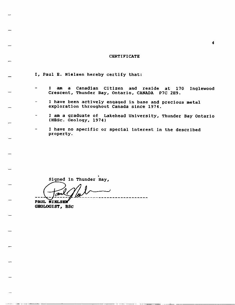
CERTIFICATE
Paul E. Nielsen hereby certify that:
I am a Canadian Citizen and reside at 170 Inglewood Crescent, Thunder Bay, Ontario, CANADA P7C 2E9.
I have been actively engaged in base and precious metal exploration throughout Canada since 1974.
I am a graduate of Lakehead University, Thunder Bay Ontario (HBSc. Geology, 1974)
I have no specific or special interest in the described property.
Signed in Thunder Bay,
PAUL NIELS GEOLOGIST, BSc

Fig. 1 x
Location Map
Mann Belt Project
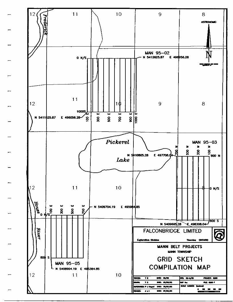
MAN 95-02N 5412625.87 E
MAN 95-03*
l 85 M 0805.28 E 497708.0*
N 54O9704.19 E 4959 14 85
FALCONBRIDGE LIMITED
MANN BELT PROJECTSMANN TOWNSHP
GRID SKETCH COMPILATION MAP
MAN 95-05- N 5408904.19 E
1 1
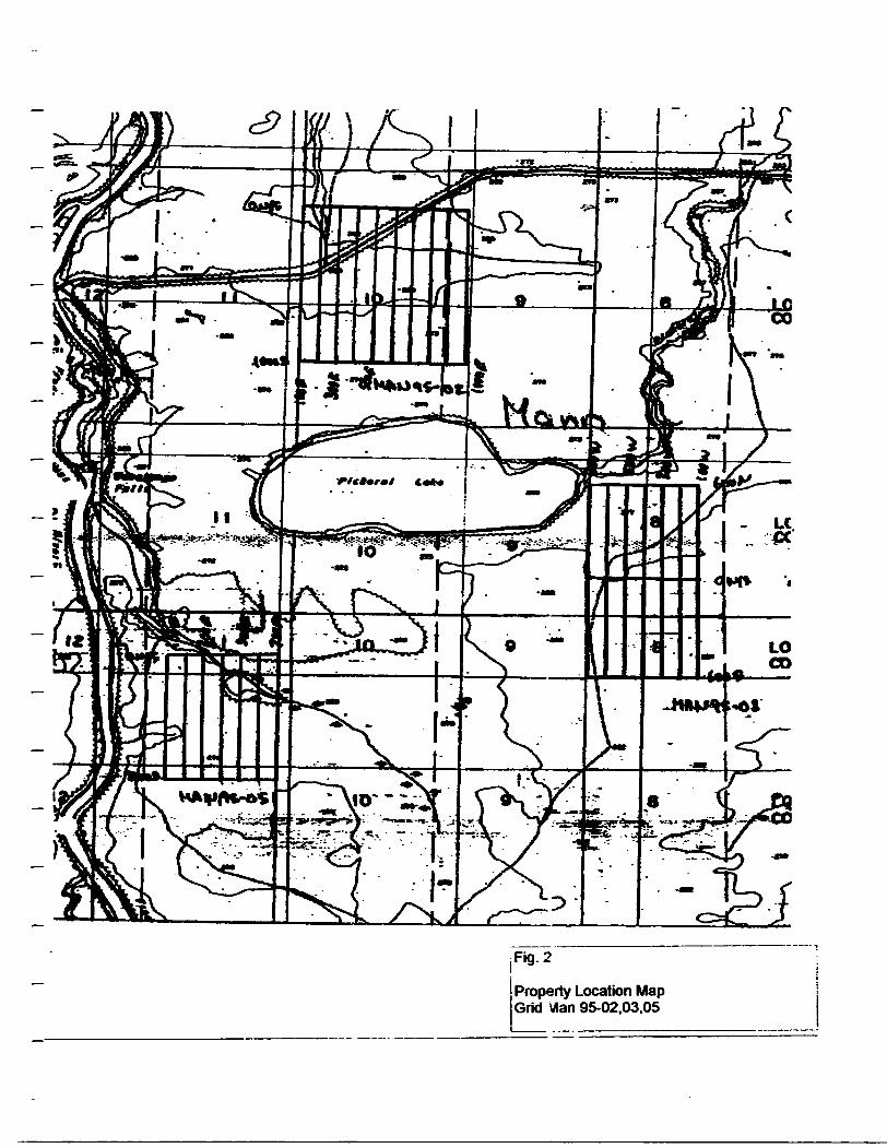
l Fig. 2i
Property Location Map Grid dan 95-02,03.05

...... |'2
00
9b
/9(7
310-
te*V
d*2.
t-m
tt!f
i*f3
Z3fi
A. L
* ^
A a.
i*
.,^fl
J&
^fc&
WW
*^
- af.
frrv
T'^
T--
'*-*
' "-
H !
TZ
T
. Ji
lBrt
^ni
i * D
201507
12 C
NIT
S
l Fig
. 3
Cla
im M
ap
Grid
Man
95-
02.0
3.05
N,

SpecificationsDynamic Range -....................... 18.000 to 110.000 gammas. Roll-ever display feature
suppresses first significant digit upon exceeding 100.000gammas. -
Tuning Method......................... Tuning value is calculated accurately utilizing a speciallydeveloped tuning algorithm .
Automatic Fine Tuning . ..................±1S'H, relative to ambient field strength of last storedvalue
Display Resolution........................ 0.1 gammaProcessing Sensitivity.................... 0.02 gammaStatistical Error Resolution............... 0.01 gammaAbsolute Accuracy ..................... 1 gamma at 50.000 gammas at 23ec
± 2 gamma over total temperature rangej Standard Memory Capacity
Total Field or Gradient.................. 1.200 data blocks or sets of readingsTie-Line Points ........................ 100 data blocks or sets of readingsBase Station.......................... 5.000 data blocks or sets of readings
1 Display............................. -. .Custom-designed, ruggedized liquid crystal display with anoperating temperature range from -400C to -t- 55*C The display contains six numeric dig:^. decimal point, battery status monitor, signal decay rati and signal amplitude monitor and function descriptors.
RS132 Serial I/O interface................. 2400 baud. 8 data bits. 2 stop bits, no parityGradient Tolerance..................... 6.000 gammas per meter (field proven)Test Mode ............................ A. Diagnostic testing (data and programmable memory)
B. Self Test (hardware) Sensor ............................... .optimized miniature design. Mayietic cleanliness is
consistent with the specified absolute accuracy.1 Gradient Sensors... - - - -. - - - - - - 0.5 meter sensor separation (Standard), normalized to
gammas/meter. Optional 1.0 meter sensor separation available. Horizontal sensors optional.
Sensor cable .......................... .Remains flexible in temperature range specified, includesstrain-relief connector
Cycling Time (Base Station Mode) ......... Programmable from 5 seconds: ip to 60 minutes in 1second increments
Operating Environmental Range........... -400C to -i-SS'C; D-100% relative .lumidity; weatherproofPower Supply .......................... Non-magnetic rechargeable sealed lead-acid battery
cartridge or belt; rechargeable HiCad or Disposable battery. cartridge or belt; or 12V DC powt-r source option for base l station operation.
Battery Cartridge/Belt Life . . .. . . - 2.000 to 5.000 readings, for sealed lead acid power supply.depending upon ambient temp .vature and rate of readings
weights and Dimensions instrument Console Only............... 2.8 kg. 238 x 150 x 250mmNicad or Alkaline Battery Cartridge ...... 1.2 kg. 235 x 105 x 90mmNicad or Alkaline Battery Belt............ 1.2 kg. 540 x 100 x 40mm
- Lead-Acid Battery Cartridge ............. 1.8 kg. 235 x 105 x 90mmLead-Acid Battery Belt.................. 1.8 kg. 540 x 100 x 40mmSStentSensor " 1-2lc9' 56mmdiameterx200mm ^o'STSSo^e
(O.Smseparation-standard)............ 2.1 kg. 56mm diameter x 790mm canadaM*}13110Gradient Sensor Tele* 0625222 EDA TOR(LOmseparation-optionalK........... .2.2kg. 56mm diameter x 1300mm cable instruments Toror
Standard System complement............ instrument console; sensor; 3-m iter cable, aluminum I41S 42S 7800sectional sensor staff, power sur ply. harness assembly. w u.sjv. operations manual. listwardRoad0lrK
Base Station option.................... standard system plus 30 meter cable wheat Ridge. Colorado1 Gradiometer Option ................... standard system plus 0.5 meter j ?nsor
Printed in canada

SPECIFICATIONS :
222.444. ODD. 1777 and 3555Hz. PSepecsnuiiity :
iV:ot.!ec of Operation: MAX: Tn Ctl Dilpte
Coii Separations:
i and re ceiver coil plane horizoneal CMax-coupted; Hi/SzonCaMoop mode). Used wich refer, cable.
MIN: Transmitter coil plane horizon- tal and receiver coil plane ver tical (Min-coupled mode). Used wich reference cable.
V.L. : Transmitter coil plane verti cal and receiver coil plane hori zoneal CVereical-loop mode). Used wichouc reference cable . in parallel linea.
25.5O.-00.150.200 SSSOm (MMD) or 1OO. SCO. 3OO. 4OO.6OO and SOO ft. C MM H F ) . Coil aeperaeions in-VL.mode not re stricted to fixed- values.
Ti-iinumi ccer lotteries
Cable :
-amcfters Read: - and
Satiate Plangus :
compo-the secondary field in
MAX and MIN modes.
- Tile-angle of the total field in V.L. mode .
- Automatic, direct readout: on SO mm 13.5") edgewise meters in MAX and MIN modes. No null ing or compensation necessary.
- Tile angle and null in 9Qmm edge wise meters in VL.mode.
In-Phase: 2OX. 1COX by push- bucton swicch .
Quadrature: 2OX. 'DOX by push button switch.
Tile: *75* slope.NulKVLJ: Sensitivity adjustable
by separation swicch.
Voice Link :
Indicator Lie Fits:
O.5*i co 1* normally, depending on conditions, frequencies and coil separation used .
- 222Hz : 175Atms- 444Hz : IBOAcm2- SSSHz : lOOAem3- 1777 Hz : BOAtm3-3555Hz: 3OAtma
: 3V trans, radio type batteries (4). Life: approx. 35hrs. continuous du ty (alkaline . O.5 Ah). less in cold weather.
12V 7.5Ah Gel-Cell rechargeable batteries C 2 x 6V in series ].
Light weight 2-eonduceor teflon cable for minimum fi icciui i. Unshield ed. All reference cables optional ae excra cose. Please specify.
Built-in intercom system for voice communication between re ceiver and transmitter operators in MAX and MIN modes, vie re ference cable .
Buile-in signal and reference warn ing lights to indicate erroneous readings .
: -4O-C to*6O-C t-4O*Fto*VJO-F).
Weight: 6kg (13lbs.)
: 13kg C23lbs.)
Readability: l n-Phase and Quadrature : Tile : 1X
OS*.
-: Typically 6Okg C135lbs.J. depend ing on quantities of reference cable and batteries included. Shipped in two field/snipping conon.
Specifications subject, co change without notification.
APEX P A R A IVI E T R fi C S i-I MIT ES O2OO STEEL-CASE RD. E.. MARKHAM. ONT.. CANADA. L3R 1(32
Phone: C416) 435-1612 Cables: APEXPARA Telex:06-366773 NORDVIK TOR

Northern Development and Mines
Ontario
ui 11 CM ivAfter Recording Claim
Mining Act
1 ransacuon Number
PeraooallrdDnnalteftcoladad on tola term h obuJftad under ttatMa coiectlon ahouU be dtocted to (he Provincial Manager. Mining Land*, rSudbury. Ontario, P3E 6A8, telephone (709 670-72S4.
Instructions:
42A14SEOO19 2.16307 MANN
Please type or print and submit In duplicate.Refer to the Mining Act and Regulations forRecorder.A separate copy of this form must be completed for each Work Group*' * X \JTechnical reports and maps must accompany this form In duplicate.A sketch, showing the claims the work Is assigned to, must accompany this form.
900V'f
Recorded HoMwts)
LIMITED* No.
571 P-0. HH-O . Ortt.Telephone No.
TowraMp/ArM
MA A/ A7or Q No.
EL-Work Performed (Check One Work Group Only)
Work GroupTyps
HLEK txwoty*r* AW ttxAos 4
RehabilitationOther Authorized Work
AssaysDEC 1 5 1395Assignment from
OSvfVOMINING L4A,DS
Total Assessment Work Claimed on the Attached Statement of Costs SNote: The Minister may reject for assessment work credit all or part of the assessment work submitted if the recorded holder cannot verify expenditures claimed In the statement of costs wHhln 30 days of a request for verification.9Persons and Survey Company Who Performed the Work (Give Name and Address of Author of Report)NameAddress
fco* 32 fei ~tVsiAr*Wc drrt. SEAUtlltlAt vid. P*m S V2
(attach a schedule If necessary)
Certification of Beneficial Interest * See Note No. 1 on reverse side
.stledlnlhacurrartriolder'tnwnoorrieWuixlwabenellcWlmera*i oy ir. -
Certification of Work Reportl certify that l have a personal knowledge of the facts eat forth In ttila Work report, having performed the work or wltnesaed aame during and/or after Ita compleflon and annexed report la true.__________________________________________________
Name and Addraw of Penon cwnymg
PAUL SJA&efcu 571Gale . OfiV.

Ministry ofNorthern Developmentand Mines
Ontario
Report of Work Conducted After Recording Claim
Mining Act
Transaction Number
. OP'150Personal Information collected on this form to obtained under the autrwrlty of the Mining Act This Infonnatkxiwl be used fwthis collection should be directed to the Provincial Manager, Mining Lands, Ministry of Northern Development and Mines, Fourth Floor, 159 Cedar Street.Sudbury. Ontario, P3E 6AS. telephone (705) 670-7264.
Instructions: - Please type or print and submit In duplicate; - -1- Refer to the Mining Act and Regulations for requirements of filing assessment work or consult the Mining Recorder.- A separate copy of this form must be completed for each Work Group. O * /j ^ ~- Technical reports and maps must accompany this form In duplicate. eV * X O O Lt A- A sketch, showing the claims the work Is assigned to, must accompany this form. 9
Recorded HoWeite)Cflertf No.
Addreet P.O. Ave. ~T7nrtir*S
Tvwpnono No*
Mining OMston TownsMp/Area M or O Plan No.
Work Performed (Check One Work Group Only)Work Group
Geotechnical SurveyPhysical Work, Including Drilling
RehabilitationOther Authorized Work
AssaysAssignment from Reserve
Type
L-'fosE. c-oTi rot, n.f^j/vieiT'i c. -v H CE.l~i ^^Xf- \) c Y.S
REGFlx ^c""————————————————————————————————— nep l n T-1G C — ' — — — ——UC.U ^ *f t*f*"-
MINING UNubor^.^.-o 1 H^T Gf •dfcSO- Total Assessment Work Claimed on the Attached Statement of Costa S ,. . o? i 1 L TTrrFH-
^sNote: The Minister may reject for assessment work credit all or part of the assessment work submitted If the recorded holder cannot verify expenditures claimed In the statement of costs within 30 days of a request for verification.
tPersons and Survey Company Who Performed the Work (Give Name and Address of Author of Report)
Name Address
Bc-) n oiofcE.1. Pf
(attach a schedule If necessary)
Certification of Beneficial Interest * See Note No. 1 on reverse sidel -. 3rtify that at the time the work was performed, the dalms covered In this work report were recorded In the current holder's name or held under a beneficial Interest by the current recorded holder.
Date Recorded Hodt, of'Xgem (Slgnaturoj
Certification of Work Reportl certify that l have a personal knowledge of the facts set forth In this Work report, having performed the work or witnessed same during and/or attar Its completion and annexed report Is true.
Name and Address of Penon Certifying
Qdepone No. Certmed By (Slgaeture)
For Office Use OnlyTotal Value Gr. Recorded Del* Recorded
Deemed Approval Date
Dele Notice for Amendments Sent
Mining Recorder
Dale Approved
0241 (03*1)

ii
E; c
0
v8
-C
8CO If
r-,
lN* UvJCD
^fj oo
otal ValueN Oo
(P
HECFJ1DBCl!
MIMNGlAN
Credits you are claiming in this report may be cut back. In order to minimize the adverse effects of such deletions, please indicate from which claims you wish to priorize the deletion of credits. Please mark (x) one of the following:1. O Credits are to be cut back starting with the claim listed last, working backwards.2. O Credits are to be cut back equally over all claims contained In this report of work.3. D Credits are to be cut back as priorized on the attached appendix.In the event that you have not specified your choice of priority, option one will be implemented.
lote 1: Examples of beneficial Interest are unrecorded transfers, option agreements, memorandum of agreements, etc., with respect to the mining claims.
lote 2: If work has been performed on patented or leased land, please complete the following:l certify that the recorded holder had a beneficial Interest In the patented or leased land at the lime the work was performed.
Signature Dale

ff3 0*r
(bi
2. I
.
.
81M)7
^-
c?9
*
-D
suO3)j:
*
8!!-gl?'
IM1
1 f
Ir
"t o
C
-
0
Q
G
QJ
Value of AsMMflwnt Work Done on this Claim
*
,i3 ^
i
ott
5: ,
s
M
REi
NIN(
CEEC j
LAf
'\\ *
5 1H
Ob.
•J.*
.^
ta^
i?
-
.
{^
S
Is**c 3 ?-j|
j*
Credits you are claiming in this report may be cut back. In order to minimize the adverse effects of such deletions, please indicate from which claims you wish to priorize the deletion of credits. Please mark (f) one of the following:1. D Credits are to be cut back starting with the dalm dated last, working backwards.2. O Credits are to be cut back equally over all claims contained In this report of work.3. D Credits are to be cut back as priorized on the attached appendix.In the event that you have not specified your choice of priority, option one win be implemented.
lote 1: Examples of beneficial Interest are unrecorded transfers, option agreements, memorandum of agreements, etc., with respect to the mining claims.
lote 2: If work has been performed on patented or leased land, please complete the following:l certify that the recorded holder hid a beneficial interest In the patented or leased land at the time the work was performed.
Signature Date
OnRtrio
Ministry ofNorthern Developmentand Mlnee
Oevetoppement du Nord at daa nilnaa
Statement of Costs for Assessment Creditftat des coOts aux fins du credit devaluationMining Act/Lol sur les mines
Paraonal Information coOectad on tMa form la obtaJnad undar tha authortty of nw Mining Aet Thla Information wOJ ba uaad lo maintain a record and ongoing stalin of tha mining ctoknfi). Quaatlona about thla codec Don should ba drafted to the Provincial Manager, Minings Unda. MMetry of Northern Development and Mmaa. 4th Floor. 169 Cedar Street Sudbury. Ontario P3E 6AS. telephone (705) 670-7204.
2. 163 07Lea renaelgnementa personnels contemn dana la presente formula aoni racuena an vertu de to Lot aur lea mlnee et servlront a tenlr 4 Jour un regbtre dee coneaaalona mlnlerea. Adraaaar toute question aur to colece de ces renaelgnementa au chef provincial daa terrains mmtora. ministers du Devetoppament du Nord at daa Mlnee. 159. rae Cedar. 4* 4tage. Sudbury (Ontario) P3E 6A6, telephone (70S) 670-7264.
1. Direct Costs/Couts directs
Type
SaWrea
and Coneultant's
DraNad* r entrepreneur etderexpert.
Foumlbiree
tocatfonde
Labour Maln-d'oeuvreField Supervision Supervision aur to terrain
Typs U\U
F.Type
w;
Typ*
TUUC.IC
iVTV
Amount
3F/5
TotaJs Total global
ao-oo
\0.ftO
4oooTotal Direct Costa
Total de* coOts direct*
3835
'fi .ffi
2. Indirect Costs/CoOts Indlrects** Note: When claiming Rehablltallon work Indirect costs are not ailowcwtv M ttSMsnwnl wofk*
Pour to remboursement daa travaux de r*hablOiaaon. lea coflta InrJrecta ne sent paa admlasUea en tent que travaux d'evahiaHon.
Type
Transportation Tianaport
Food and LodgingNouifttura 01
HoolilaUllon MM
Type
DEC l 5
MINING LANU
Amount Monlunt
Sub Total of Indirect Coat* Total partial dea coOta Indlrects
Amount Allowable (not greater than 20H of Direct Costa) Moment admissible (n'exosdent paa 20 H dea coots directs]Total Value of Assessment Crsdtt Vstaur totals du crsdft (Total of Db*et and AOowaM* d'svshisOon Mlract coats) (ToMdtt
sttadbM
Totals Total global
Note: The recorded holder wil be required to verify expenditures claimed In this statement of costa wNMn 30 days of a request for verification. If verlAcaUon to not made, the Minister may reject for assessment work el or part of the assessment work submitted.
Note: Le tfao^lreenregtotre sera tenu de ve^tfter lee defenses dsmsndessdsni to present 4tat dea coOta dana toa 30 Jours aulvant une demands i cet effet 81 to verification n'eat paa effoctuea, to mMstre peut retotar tout ou une partto dea travaux d'evaluatlon preatntaa.
FIHng Dlacounta
1. Work filed within two years of completion la claimed at 1009* of the above Total Value of Assessment Credit
Remises pour depot
1. Les travaux deposes dans tos deux ana sulvant tour achevement sort rembourses s 100 ** da to vatourtototo susmentlonnee du crMd'evaJuaflon.2. Work filed three, four or five years after completion to claimed at
tt of the j ove Total Value of Assessment Credit See bdow:
. c'rJ'VsJue d Assessment Crsdl TSST:L x 0.50 -
2. Les travaux deposes trols, quatre oucjnq an* ."pr5" ir - -r achevemr.^ sont rembourses a 50 H de la valeur''Oi;.L^ ; ;^dH d'evaluftUon susmentlonn*. Volr les calcuto cWessc-js.
Vstow totals du credit d*evalualton Evaluation totals demands*.x 0.50 -
Certification Verifying Statement of Costs
l hereby certify:that the amounts ehown are as accurate aa possible and these costs were Incurred white conducting assessment work on the (and* shown on the accompanying Report of Work form.
that aa(Rscordsd HoUar. Agart. PoaMon h company)
to rnake thte certfficatlrjrvv
Attestation de I'eiat des coats
J'atteste par la presente :que lea montanta Indlquea sont le phi* exact possible et que ces depenaea out M engage** poUr effectuer toe travaux tfevaJuatJon aur lea terrains Indlquea dana la formula de rapport de travaOcHolnt
. l am authorized Et qu'a tJtre deposts occups dana la
suteautortee
i falre cette attestatJon.
55T
OCT 11 19950212 (Mtl) l ota: Dans cette tomula, torsqul dtekjne dal personnes. Is mssculn s*t ut** au sens nsuire.
OH to "15

Ontario
Ministry ofNorthern Developmentand Mines
Mlnlsiere du Devetoppemenl du Nord el des mines
Statement of Costs for Assessment Credit
des coflts aux fins du credit devaluationMining Act/Lol sur les mines
Transaction NoJN* de transection
2.16307Personal informetion coiiecied on this form Is obtained under (he authority ol the Mining Act. This Information wfll be used lo maintain a record and ongoing status of the mining claim's). Questions about iMs collection should be directed lo the Provincial Manager. Minings Lands. Ministry of Northern Development and Mines. 4lh Floor. 159 Cedar Street. Sudbury. Ontario P3E 6AS. telephone (705) 670-7264.
Lea renselgnemenis personnels conlenus dans la prdsente formula sonl recueffis en vertu de la Lo! sur lea mines el servbom a lenlr a Jour un regjsire des concessions mmleres. Adresaer (oule question sur la coHece de ces renselgnements au chef provincial des terrains mintors. mmbiere du Devetoppemenl du Nord ei des Mines. 159. rue Cedar. 4* Mage. Sudbury (Ontario) P3E 6A5. telephone (705) 670-7264.
1. Direct Costs/CoOts directs
Type
Wagee Selalree
Contrector'e and Consultant's FeeeDrolls de ('entrepreneur et de ('expert' consen
Supplies Used Foumltures utIIMes
Equipment Rental Location de materiel
Description
Labour Makvd'oeuvreFtokf Supervision Supervision sur le terrain
Typs fOlC C*e*'fl|ftics
TrP*
TIP*
Amount Montan!
3?i?*
Total Direct Coste Total dee couls'tilrects
Totals Total global
iPSl
cPs*?
2. Indirect Costs/Couts Indlrects* * Note: When claiming RehaMHaUon work Indirect Rowttbto it MMsinMt woriL
Pour to ynbourttmsMU du iravaux d* rtfitWttmilon, IM oooto IndeTVCtB iw onl pu d'evaluallon.
Type
TfaVMpOft
Food end LodgingMomiliufe eiMb*rg*m*ntMoblUelton end OemobBbetton WoMDMtlon el demebfllsMlen
* — - - — J AM^A..Kkl^ 1
MonUnt admlasMeTotal Value of Aese (Tew ol Otntt Mid 1 tadkMl *Mte)
DeecrlpttonType
-B^P™ JTI
Amount Montanl
.••—it * *—ncLjni*DEJI 1 5 m
MINING Lf\NOb o,
Sub Total of Indirect Costa Total partlel dee coOte Indlrectsnot greater than ZOU of Direct Cotte) (n'excMant pas M H dee coOU dkede)Minent vredlt ValsvT lotsle du creoll JtoweMe d evatvettoo
tToW tfn MHi *Mfi
Totals Total global
rv i V s"
^^
o?^/
Note: The recorded holder win be required lo verify expenditures claimed In (his statement of costs within 30 days of a request for verification. II verification Is not made, the Minister may reject for assessment work aB or part of the assessment work submitted.
Note: LetituWreenraojsUe sera tenu de vorfSer les depenses demands* dans le present Mat des coots dans lee 30 Jours sulvant une demande a cal effet. SI le verification n'est pas effective, le mlnlstre pent rejeter tout ou une partle dee travaux d'evaluallon presenMs.
Filing Discounts
1. Work Hied within two years of completion Is claimed at lOOtt of the above Total Value of Assessment Credit.
2. Work filed three, four or five years after completion Is claimed at 504b of the above Total Value of Assessment Credit. See calculations below: 'Total Velu* ol Asswsmtnt CredH
X 0.50 -
Remises pour dapot
1. Les travaux deposes dans tos deux ens sulvant lew achevement sonl rembourses a 100 H de la vatour Mate susmenConnee du credH d*evalusilon.2. Les travaux deposes trois. quatre ou dnq ens apr** tour achevement eont ramboura4s a SO H de la valeur totale du credit d'evaluallon susmenttonne*. Volr tos calculi cMessous.Vekwr Male du creMwvenmuon
x 0,50
Certification Verifying Statement of Costs
l hereby certify:that the amounts shown are as accurate as possible and these costs were Incurred while conducting assessment work on the lands shown on the accompanying Report of Work form.
oe rEtt-fl(hat as .________ ̂(Recorded HaUu. Agon. Position hi Company)i
lo make this certification
Attestation da I'itat dee couts
J'atteste par la presents:que les montants Indlquee eont to plus exact possible el que ces depenses ont M engagers pour effectuer les travaux devaluation sur tos terrains Indlques dans to formula de rapport de travail ci-joint.
l am authorized El qu'a litre de( Make ewegfcln). repr*Mntanl. pen* eeeup* dent k
a falre cette attestation.
sub autoris*
Note: Dans cene lomwle. loreoyi dtokjne des personnes, le maeculn eat ulBM en sens Asube.

OntarioMinistry of Ministere du Geoscience Approvals OfficeNorthern Development Developpement du Nord 933 Ramsev Lake Roadand Mines et des Mines 6tn p^o^
Sudbury, Ontario P3E 6B5
Telephone: (705) 670-5853 Fax: (705) 670-5863
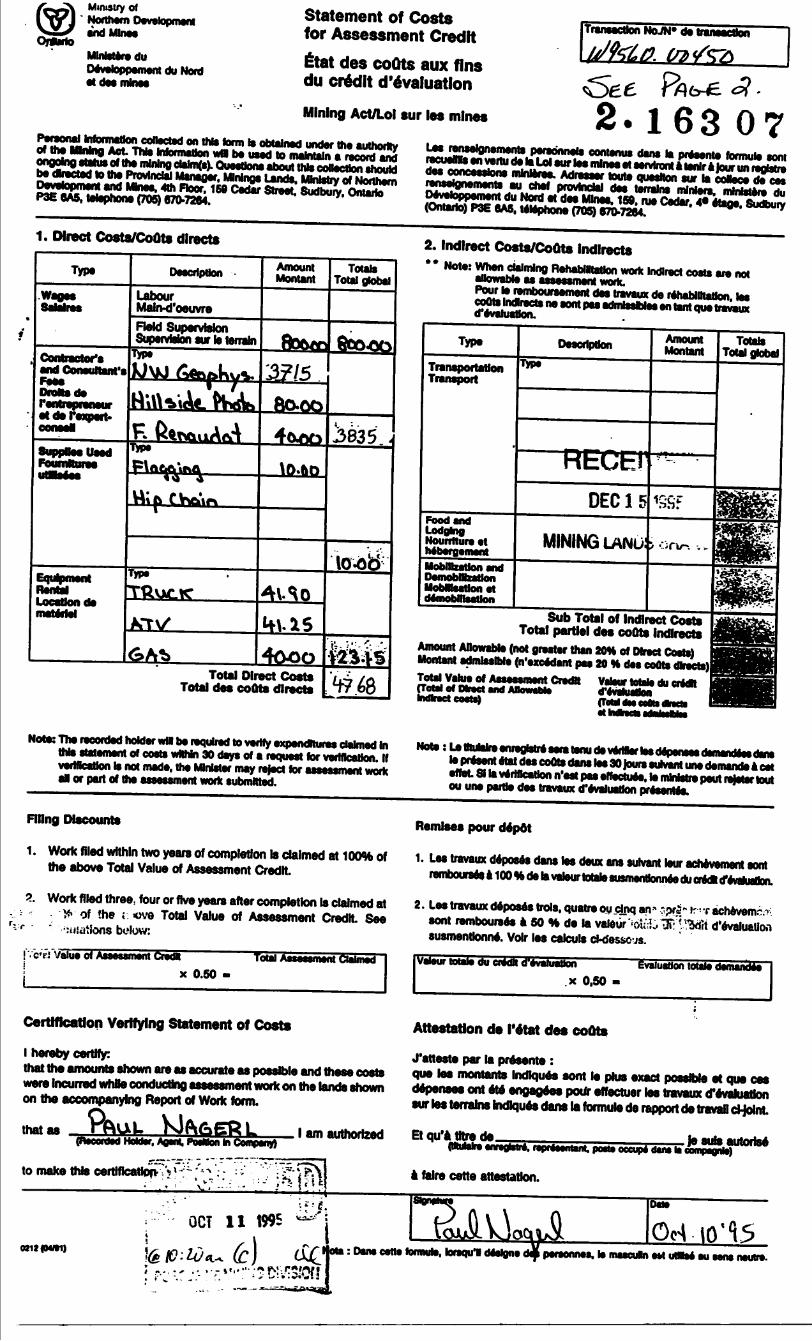
December 20, 1995Our File: 2.16307 Transaction f : W9560. 00450
Mining RecorderMinistry of Northern Development t Mines60 Wilson Avenue, 1st FloorTimmins, OntarioP4N 2S7
Dear Mr. White:
Subject: APPROVAL OF ASSESSMENT WORK CREDITS OM MINING CLAIMS 1200948 i 1200947 IM MAMM TOWNSHIP
Assessment credits have been approved as outlined on the report of work form. The credits have been approved under Section 14 (Geophysical) of the Mining Act Regulations.
The approval date is December 18, 1995.
If you have any questions regarding this correspondence, please contact Steven Beneteau at (705) 670-5855.
Yours sincerely, ORIGINAL SIGNED BY:
Ron C. GashinskiSenior Manager, Mining Lands Section Mining and Land Management Branch Mines and Minerals Division
SBB/jl
cc: Resident Geologist ^/Assessment Files Library Timmins, Ontario Sudbury, Ontario
A/*5!

01o*01 lo
ID
ARbAS .WITH n 'A'*;. . FROM DISPOSITION
to.R.O. FINING RIGHTS ONLY
8.R.O. - SURFACE RK HTS ONLY
M^ S. - MININf \HU SURFAv'E r.
DMcnpticn Order No. O*ti O'tposttion FiU
s:
01OJOilo
WO 87 l 87
SECTlOirjM^Of TMC MININ9 WT ~^ OCTOBER ISr 198T ) *w* "ftt* 894P53
SURFACE MUD MIMNO RIGHTS RE-OPENED TO PROSPECTING. STAKMG OUT. SALE OR LEASE UNDER SECTION M OP THE MMMG ACT RAO. I9SO EFFECTIVE 90-SEP-O8 AT 7AM E.S.T ORDER NO. 0-P 4/90 NR DATED 90-AUG-22.
NOTE* PI 125837 PLOTTED IN ERROR.
S/B PIII4737.
e
THE INFORMATION THAT APPEARS ON THIS MAP HAS BEEN COMPILED FROM VARIOUS SOURCES, AND ACCURACY IS NOT GUARAWTEED THOSE WISHING TO STAKE MIN ING CLAIMS SHOULD CON SULT WITH THE MINING RECORDER, MINISTRY OF NORTHERN DEVELOP MENT AND MINES, FOR AD DITIONAL INFORMATION ON THE STATUS OF ThE LANDS SHOWN HEREON
ANN ; v IN-
IIIBL^fiQ
HU264.
U units)
^*- ' * ~ ^ P/ V^UA.'
1200927I200928
o ^ft-A
P i ~ k e r e l L a k j , -
I2C0338
-
12013737BOOOO
I20O925 inAsft
1I^I-*J*1 IIIOUO0
1180029
(4 UNITS)
**ee* ma/a
^!JS) .^^/^y""
1113 36** ~ ~
1200909^
s
'T
UIVOC^
l}
4BB494
"^4HM8&/ A
r(-1*9696
1V\
•li
'9 S O ^3T
812573
-4IO4MkA-- 4U23&1-
Qx-/^. \-~. __ , ___ _ _ ^^^S I20C
^v--"V
juAftT. limps
X^ (8 L
jifc
I20C
; nuacB ' -w
\
(8 UNITS
910-yucfro ^s
-- "^T H***
NITS) \
H916
w ' fi JOT v OO|
"V/-
^^"1 - — -j"*g?7- _
P mac? t i p
200683 l 1200684 ( l
. l ma. 7P
L9O2
(12 ur
v2 UNITS)
? li.|Nn^---Z L
1,69*?.
I2OO906
N
ITS)
-T2OO90I
f
"^ 1200908^
(l6 UNITS)
I2009I9
(4 UNITS)
*P
Of* Tfil A i CTC1I it
*92O
A^
OOrt^jl^l
l e UMi l b) ^~
* Jj7 ftSS 538s
P
(8 UNITS)
VI
(12 UNITS)
——— -J IVm
12
337
1334 ! *I335
^\
^•{Sz- f44(0*4 4460BI
44*IOt
(16 JNITS)ogy fl^gp
44CIO9
*.'
44'ilOZ 446101
446O9V J! 44(130
44(09B I 44(OtT
4*0*? (O 448093 44'096
I
\ ---- j , •^...-.L . ..JL -\_-JL_ ..J1.
***** ' *^^ ^ P \ H
'- X 46073
995135
44*094 446093
4 4 6 O 9 '
-Bfi-?-oH3- 8 67683
mH
1200921
(4 UNITS)
-BJ3644 •^•^9 A^O' 9 T 5 *^ 5O
/i 4IIMM-
VMM- mm JNITS)
1200924
ft 6 T oO^ \
UlJITS)
1201901
16 UNITS
osasBi-
I2OO923
44-2678-
HI3fifi7
IIH670
l NITS)
03B500 -**8frBS-
I20I9O2 4 UNITS
' ""677 ^^^HaJt'
Bf*4*? -*
1201903 ~ 8 UNITS
Q4BT80 Bi/BBB | *****4
^^ UNITS
lil C/)X
II
LITTLE TOWNSHIP
r.HIGHW ' -'U ' '
H'" .OA.-j
TRAP S
'OHVi i fU LIM c-
TOWNSHI ^LOT 1: "" Mb
1 iN -i I R V? ' 'L (,( L , * f
P^xRf f-L BCji,' !' H v
MIMNG CL A "' r T J
RAIL'.VAV/r -IIGH O F WAY
UTIL'T y L INES
NON PS- H.:N,, AL. G"i ' EAM
FLOODING CM H CV
SUBDIVISION O HCJVPt .ut PL
RFSER.ATIONS
O VICINAL SHORELINE
K ARJTHOR MUSKEG
MINES
RAVERSE M ONUMENT
-0- t-*r ~1-
DISPOSITION OF GR LA* i.
TYPE OF DOCUMENT S^Kfl
P/STENT SUHFACE t-MINING RIGHTS..
.SURFACE RIGHTS ONLY .... ..
MINING RIGHTS ONLY
LF^SE.r.lJRTACE Si MINING RIG *TS
' .SURFACE RIGHTS ONLY ..... .
. MINING n^'tTSONLY. .. .. .....
LICENCE OF L CCDPATiON ,.
ORDER IN COUNC'L ........
RESERVATION .......... . .... ............
CANCELLED
SANT 8, G RAVEL .........___.. .....LAND USE PERMIT- —————————————— —- --NOTE MINING RIGHTS IN PARCELS P* TENTED PWK' . l
1913. VESTED I N ORIGINAL PATENTLF B v '
LANDS ACT R SO 1970 CHAP 3BO SFC 6. . \Jt
41e 'jmH
J
L (A P.
SOO
10 10 It. 30 40 SOhains int
SOO O 1000 2000 3000 4000
SCALE 1:20 O C
SNOWMOBILE TRAIL ( LAND USE PERMIT ) NOTICE RECEIVED 92-DEC-O9
'2.163
DFC 1 3 199 i
PORCUPINE MINING DIVISIO^j
RECEIVEDDEC 15 1995
D
TOWNSHIP
MANNMMR. ADMINISTRATIVE DISTRICT
COCHRANEMINING DIVISION
PORCUPINEl AND TITLES/ REGISTRY DIV
COCHRANE
Ministry ofNaturalRceour^es
Ontario
Ministry ofNorthernand
D*StPTEMHER ' 986
G-3537
i
l
01 l
(D
200

s.5* b
fs,
s
i if
y
LJCD CD
CD CD CXJ
UJ CD CDro
CD CD
CD CDin
CD CD
CD CDr--
sr—
BASELINE 0+00
TIELINE 8+OOS
* J 63 07DEC 1 5 1995
lOdn 5(h h i i i i i l Oh aa*,
USE0019 2 16307 MANN210
GRW MAN 95-05
lustrum*Field
Brhni TOTAL
i 59*6*. 9 nT
Contour In-tcrval i
Conductor Axis
FALCONBRIDGE LOOTEDMAGNETOMETER SURVEY
PROJECT. MANN BELT PROJECT f i 8269
BASELINE AZIMUTH i 90 Beg.
SCALE = l i 5000 SURVEY BY i NWG
DATE i 9/12/95 NTS i 42 A/14
NORTHWEST GEOPHYSICS LTD.

•o
ip
y
s
i
9
i ffis
CD CD CU
CD CD CO
CD CD "Sf
CD CDin
CD CD
CDCD
BASELINE 0+00
TIELINE 8+OOS
- l 63 07crr^ v *
DEC l 5 1995
MINING LANDS
lOOh 5b to i i i i i l Oh
lustrum* i OMIField i TOT*.Drh* i 59M0.8 nT
Contour Intcrvtl i
Profile Scale i 50 nT 7 O
Conductor Axil i
FALCONBRIDGE LOOTEDMAGNETOMETER SURVEY
PROJECT. MANN BELT PROJECT f i 8869
BASELINE AZIMUTH i 90 Beg.
SCALE = l i 5000 SURVEY BY i NVG
DATE i 9/12/95 NTS i 42 A/14
NORTHWEST GEOPHYSICS LTD.
220

fCJI
s
7 S
l3,
L
i s
y x
CDCD
CD CD OJ
CD CD
CDCD
CD CDin
CDCD
CDCDr-
BASELINE 0+00
\f\l
o
TIELINE 8+OOS
i
3.16307RECEIVEP
DEC 151995
MINING LANDS BRANCH
1MB 15flh Oh
Instrunnt i DMIField i TOT/*,•kiwi i 59***. O UT
Con-tow Inter-mi i 1O8 iff
CoBductor Axis
230
FALCONBRIDGE LOOTEDMAGNETOMETER SURVEY
PROJECT. MANN BELT PROJECT i i 8269
BASELINE AZIMUTH i 90 Beg.
SCALE ^ l i 5000 SURVEY BY i NVG
DATE i 9/12/95 NTS i 42 A/14
NORTHWEST GEOPHYSICS LTD.

23
a0 **.45
O O
sf
Iw rf-
BASELINE 0+00
c x
TIELINE 8+OOS
CD CD
NJ CD CD
OJ CD O
CD O
en CD CD
CD CD CD
CD CD
y
s
l 63 0 7
DEC l 5 1995
MINING LANDS BRANCH
GRW MAN 95-05
c1MB |5fti | (h IMi 88th |S
^YX
IncinMnt MMMINColt Spacing tStH Vertical Scale leu * IK FrequMcy 44t Hz In Phase 02Duufrvture OZ
1
FALCONBRIDGE LOOTEDHLEM SURVEY
FREQ. 440 HERTZPROJECT. MANN BELT PROJECT i i 8269
BASELINE AZIMUTH i 90 Beg.
SCALE * 1 1 5000 DATE i 9/ 9/95 SURVEY BY i NWG NTS i 42 A/14
NOWHWEST GEOPHYSICS LTD.
240

fM
k
myTJ
I
f3 9;•o
l
y
s
g y
S
f
BASELINE 0+00
o
TIELINE 8+OOS
2.16307
MAN 95-05
lOfln 5fc h INn 2Mb i i i i i_______i_______i
250
N
Instrunmt
Coll Spacing Vertical Scale
In Phase
Quuv^tare
HMMIN
15*i
lot = 20Z
1761 Hz
IS-tsz
FALCONBRIDGE LIMITEDHLEM SURVEYFREQ. 1760 HERTZ
PROJECT) MANN BELT PROJECT i \ 8269 BASELINE AZIMUTH i 90 Beg.
SCALE = li 5000 SURVEY BY i NUG
DATE i 9/ 9/95 NTS i 42 A/14
NORTHWEST GEOPHYSICS LTD.