Geomorphological approach for earthquake-induced ...hasegawa/publications/2008/... ·...
13
1 Geomorphological approach for earthquake-induced landslides study Shuichi Hasegawa 1 *, Atsuko Nonomura 1 , Ranjan Kumar Dahal 1, 2 , Tomida Yuichi 3 , Mori Haruki 3 , and Ryuichi Yatabe 4 1 Dept. of Safety Systems Construction Engineering, Faculty of Engineering, Kagawa University, 2217-20, Hayashi-cho, Takamatsu City, 761-0396, Japan 2 Department of Geology, Tri-Chandra Multiple Campus, Tribhuvan University, Nepal 3 West Nippon Expressway Company Limited, Takamatsu, Japan 4 Department of Civil and Environmental Engineering, Ehime University, Matsuyama, Japan *Corresponding author’s email: [email protected] Abstract Regional scale planning in the mountainous terrains of earthquake prone zones need deliberate study of earthquake-induced landslides potential. Studies demonstrate that the damage from earthquake-induced landslides is sometime worse than damage related to the shaking and rupture of the earthquake itself. Although, there are many methods to evaluate earthquake-induced landslides susceptibility, the geomorphological approach is found to be easy and suitable methods for regional evaluation. This paper described characteristics of earthquake-induced landslides. It also deals with suitable and easy geomorphological approach of study for earthquake-induced landslides potential in mountainous terrains. The main conclusion of this study is that the precise DEM is adequate for the analysis of earthquake-induced shallow slope failure potential. 1 INTRODUCTION Earthquake-induced landslides are one of the most damaging natural disasters. Commonly, damage from earthquake-induced landslides is sometime worse than damage related to the shaking and rupture of the earthquake itself. Earthquake-induced landslides damage and destroy homes and other structures, block roads, destroy utilities, and dam up river and streams. After study of landslides triggered by the 1989 Loma Prieta earthquake (Moment magnitude (M w ) 6.9), Keefer (2000) pointed out that the geotechnical parameters of internal friction and cohesion did not explain the distribution and density of landslides. He also pointed out that regional-scale variations in the hazard level of seismically induced landslides might be better correlated with the geological and geomorphological characteristics rather than the geotechnical parameters. Observations of the damage patterns of earthquakes, such as the 1987 Whittier Narrows, California earthquake, the 1989 Loma Prieta (California) earthquake, the 1994 Northridge, California earthquake, the 1999 Chi-Chi earthquake of Taiwan, the 2004 Chuetsu earthquake of Niigata Prefecture, Japan, and the 2005 Kashmir earthquake of Pakistan indicate that earthquake- induced landslides generally resulted from intense shaking in elevated areas of rugged topography. Geli et al. (1988) have reported that buildings on crests suffer more damage than those located at the base and they conclude that there is always significant amplification of frequencies corresponding to wavelengths about equal to mountain width at hilltops with respect to the base. Similarly, an amplification-deamplification pattern on slopes leads to a strong energy differential on the upper part of the slope. For the case of the Chi-Chi earthquake, Lin et al. (2003) mentioned that landslide frequency is much higher on or near the crests of hills. Field experiments by Chávez-García et al. (1996) indicate that a topographic site amplification effect does exist and the amount of amplification depends on the frequency at the site location. Bouchon et al. (1996) have also confirmed that amplifications of seismic energy occur at and near the top of hills (defined as elongated elliptical shapes with an aspect ratio of 2-to-1) over a broad range of frequencies. Therefore, infrastructure development practice in the mountainous terrains of earthquake prone zones, such as Japan or Himalaya, needs extensive care on slope morphology and this paper
Transcript of Geomorphological approach for earthquake-induced ...hasegawa/publications/2008/... ·...
1
Geomorphological approach for earthquake-induced landslides study
Shuichi Hasegawa1*, Atsuko Nonomura1, Ranjan Kumar Dahal1, 2, Tomida Yuichi3, Mori Haruki3, and Ryuichi Yatabe4
1Dept. of Safety Systems Construction Engineering, Faculty of Engineering, Kagawa University, 2217-20, Hayashi-cho, Takamatsu City, 761-0396, Japan
2Department of Geology, Tri-Chandra Multiple Campus, Tribhuvan University, Nepal 3West Nippon Expressway Company Limited, Takamatsu, Japan
4Department of Civil and Environmental Engineering, Ehime University, Matsuyama, Japan *Corresponding author’s email: [email protected]
Abstract Regional scale planning in the mountainous terrains of earthquake prone zones need deliberate study of earthquake-induced landslides potential. Studies demonstrate that the damage from earthquake-induced landslides is sometime worse than damage related to the shaking and rupture of the earthquake itself. Although, there are many methods to evaluate earthquake-induced landslides susceptibility, the geomorphological approach is found to be easy and suitable methods for regional evaluation. This paper described characteristics of earthquake-induced landslides. It also deals with suitable and easy geomorphological approach of study for earthquake-induced landslides potential in mountainous terrains. The main conclusion of this study is that the precise DEM is adequate for the analysis of earthquake-induced shallow slope failure potential.
1 INTRODUCTION
Earthquake-induced landslides are one of the most damaging natural disasters. Commonly, damage from earthquake-induced landslides is sometime worse than damage related to the shaking and rupture of the earthquake itself. Earthquake-induced landslides damage and destroy homes and other structures, block roads, destroy utilities, and dam up river and streams. After study of landslides triggered by the 1989 Loma Prieta earthquake (Moment magnitude (Mw) 6.9), Keefer (2000) pointed out that the geotechnical parameters of internal friction and cohesion did not explain the distribution and density of landslides. He also pointed out that regional-scale variations in the hazard level of seismically induced landslides might be better correlated with the geological and geomorphological characteristics rather than the geotechnical parameters. Observations of the damage patterns of earthquakes, such as the 1987 Whittier Narrows, California earthquake, the 1989 Loma Prieta (California) earthquake, the 1994 Northridge, California earthquake, the 1999 Chi-Chi earthquake of Taiwan, the 2004 Chuetsu earthquake of Niigata Prefecture, Japan, and the 2005 Kashmir earthquake of Pakistan indicate that earthquake-induced landslides generally resulted from intense shaking in elevated areas of rugged topography. Geli et al. (1988) have reported that buildings on crests suffer more damage than those located at the base and they conclude that there is always significant amplification of frequencies corresponding to wavelengths about equal to mountain width at hilltops with respect to the base. Similarly, an amplification-deamplification pattern on slopes leads to a strong energy differential on the upper part of the slope. For the case of the Chi-Chi earthquake, Lin et al. (2003) mentioned that landslide frequency is much higher on or near the crests of hills. Field experiments by Chávez-García et al. (1996) indicate that a topographic site amplification effect does exist and the amount of amplification depends on the frequency at the site location. Bouchon et al. (1996) have also confirmed that amplifications of seismic energy occur at and near the top of hills (defined as elongated elliptical shapes with an aspect ratio of 2-to-1) over a broad range of frequencies. Therefore, infrastructure development practice in the mountainous terrains of earthquake prone zones, such as Japan or Himalaya, needs extensive care on slope morphology and this paper

2
highlights a geomorphological approach of slope evaluation for earthquake–induced landslides with some illustrative case studies of Japan.
2 FEATURE OF EARTHQUAKE-INDUCED LANDSLIDES
From the study of 2004 Chuetsu earthquake of Niigata Prefecture, Chigira and Yagi (2006) have classified earthquake-induced landslides as coherent landslides, rockslide avalanche and mobilization of valley fill. They did not include shallow landslides in their classification. The coherent landslide and rockslide avalanche described by Chigira and Yagi (2006) are more or less similar to Category II and Category I slides of Keefer (1984, 2000), respectively. In general, earthquake induced landslides can be classified as in the similar way of rainfall induced landslides. From the data of last 30 years, earthquake induced landslides in Japan can be classified as follow and their short descriptions are provided in following sections.
Rock fall Shallow landslides Deep-seated landslides Debris flow Debris Avalanche Valley fill failure
2.1 Rock fall
Rock fall corresponds to the similar classification proposed by Varnes (1984). It comprises a detachment of rock materials from a steep slope or cliffs and more or less free and extremely rapid descent of the material. Movement is largely through the air, alternated with the bouncing or rolling on the slope. Generally, rocky slopes of 40o-90o are more tolerable for fall during earthquake shaking. During earthquake, rock falls are very common problem along transportation routes through rocky terrain (Fig 1). Fig 1, a. Schematic illustration of rock fall and b. Rock fall at a roadside slope in Fukuoka, Japan after strong earthquake of 2005.
2.2 Shallow landslides
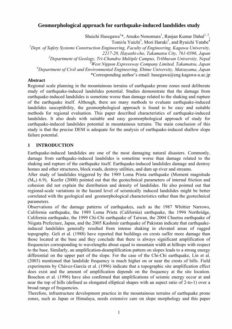
Shallow landslides corresponds slope failures having depth of failure less than 2 m. Depending on soil thickness on slope, most of the earthquake-induced shallow landslides in Japan are characterised by thickness less than 1 m. The shallow landslides comprises a detachment of slope materials from a gentle or steep slope (Fig 2). Mainly, the sense of movement of slope materials is translational or semi-translational (slightly curved failure surface). When earthquake-induced
a. b.
3
shallow landslides are concerned, usually debris slides and earth slides (Varnes, 1984) are common.
Fig 2, a. Illustration of shallow-seated debris slide in profile and b. Shallow landslides on thin soil cover on bedrock after the 1999 Chi-Chi earthquake of Taiwan.
2.3 Deep-seated landslides
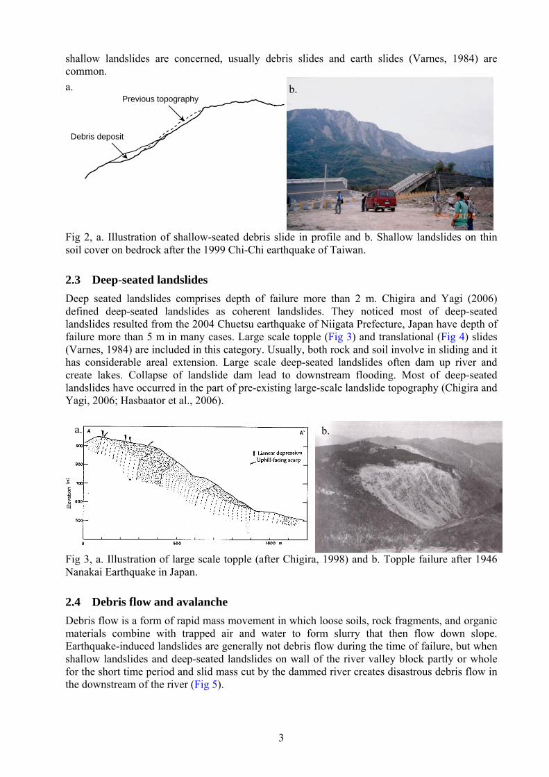
Deep seated landslides comprises depth of failure more than 2 m. Chigira and Yagi (2006) defined deep-seated landslides as coherent landslides. They noticed most of deep-seated landslides resulted from the 2004 Chuetsu earthquake of Niigata Prefecture, Japan have depth of failure more than 5 m in many cases. Large scale topple (Fig 3) and translational (Fig 4) slides (Varnes, 1984) are included in this category. Usually, both rock and soil involve in sliding and it has considerable areal extension. Large scale deep-seated landslides often dam up river and create lakes. Collapse of landslide dam lead to downstream flooding. Most of deep-seated landslides have occurred in the part of pre-existing large-scale landslide topography (Chigira and Yagi, 2006; Hasbaator et al., 2006).
Fig 3, a. Illustration of large scale topple (after Chigira, 1998) and b. Topple failure after 1946 Nanakai Earthquake in Japan.
2.4 Debris flow and avalanche
Debris flow is a form of rapid mass movement in which loose soils, rock fragments, and organic materials combine with trapped air and water to form slurry that then flow down slope. Earthquake-induced landslides are generally not debris flow during the time of failure, but when shallow landslides and deep-seated landslides on wall of the river valley block partly or whole for the short time period and slid mass cut by the dammed river creates disastrous debris flow in the downstream of the river (Fig 5).
a. b.
Previous topography
Debris deposit
a. b.

4
Fig 4, a. A typical deep-seated translational slides profile and b. Yamakosi Landslide in Niigata prefecture. It was occurred after the 2004 Chuetsu earthquake of Niigata Prefecture, Japan. This landslide dammed the Ino River for a long period of time (photo courtesy: Asian air survey). After strong earthquake, debris flow areas are usually associated with steep gullies where earthquake-induced landslides are present at upstream. When speed of debris flow is more than 150 km/h, the flow is called debris avalanche. A debris avalanche is a variety of very rapid to extremely rapid debris flow process. Debris avalanches are most common on slopes exceeding 30°. The condition of formation of debris avalanche is almost same as debris flow. Large scale debris avalanche have often occurred in volcanic region (Fig 5b)
Fig 5, a. Formation of debris flow on channel during strong earthquake and b. Illustration of debris disaster in a village after earthquake (Photo courtesy: Disaster Prevention Center, Japan)
2.5 Valley fill failure
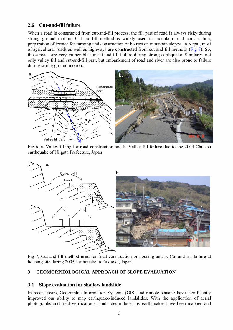
In the mountainous terrain, road or building construction some time needs filling of small creek or valley. Usually, zero order valley are subjected to valley fill during construction. Mainly debris materials from river or weathered rock and soil are used as filling materials. During earthquake shaking, such materials are extremely prone to failure (Fig 6). Chigira and Yagi (2006) defined valley fill failure as mobilization of valley fill during study of 2004 Chuetsu earthquake of Niigata Prefecture, Japan.
b.a.
River valley
Old deep seated landslide
New deep seated landslide
(http://www.bosai.go.jp/library/saigai/s14gansetu/p2ontake.htm)
b.
Valley filled sediment, volcanic ash or pyroclastic materials
a.
Ground water level
5
2.6 Cut-and-fill failure
When a road is constructed from cut-and-fill process, the fill part of road is always risky during strong ground motion. Cut-and-fill method is widely used in mountain road construction, preparation of terrace for farming and construction of houses on mountain slopes. In Nepal, most of agricultural roads as well as highways are constructed from cut and fill methods (Fig 7). So, those roads are very vulnerable for cut-and-fill failure during strong earthquake. Similarly, not only valley fill and cut-and-fill part, but embankment of road and river are also prone to failure during strong ground motion. Fig 6, a. Valley filling for road construction and b. Valley fill failure due to the 2004 Chuetsu earthquake of Niigata Prefecture, Japan
Fig 7, Cut-and-fill method used for road construction or housing and b. Cut-and-fill failure at housing site during 2005 earthquake in Fukuoka, Japan.
3 GEOMORPHOLOGICAL APPROACH OF SLOPE EVALUATION
3.1 Slope evaluation for shallow landslide
In recent years, Geographic Information Systems (GIS) and remote sensing have significantly improved our ability to map earthquake-induced landslides. With the application of aerial photographs and field verifications, landslides induced by earthquakes have been mapped and
a.
Cut-and-fill
Road
b.
b. a.
Cut-and-fill part
Valley fill part

6
analyzed in California, El Salvador, Taiwan, Japan, Italy and Pakistan (e.g., Wilson and Keefer 1985; Harp and Keefer 1990; Harp and Jibson 1996; Jibson et al. 2000; Parise and Jibson 2000, Capolongo et al. 2002; Wang et al. 2002, 2003; Chigira et al. 2003; Wang et al. 2007; Owen et al. 2008). Several methods have been developed for the evaluation of hazards represented by earthquake-induced landslides, including statistical analysis (Keefer 1984, 2000; Lee and Evangelista 2006) and a deterministic method (Mankelow and Murphy 1998; Van Westen and Terlien 1996; Jibson et al. 1998, 2000; Luzi and Pergalain 1996, 2000; Carro et al. 2003), both of which aim to quantify earthquake-induced landslide susceptibility and hazard zonation. In the deterministic method, most of the work has used the pseudo-static method or the Newmark cumulative displacement method (Newmark, 1965). Mankelow and Murphy (1998) have suggested that the cumulative displacement method proved most successful at predicting the location of shallow unstable slopes. However, deterministic methods rely on having access to detailed information, such as strength parameters and sliding depth, which are not readily available in many cases. Some studies have also focused on general correlations between earthquake-induced landslide occurrence and slope steepness, distance from the earthquake’s source, or underlying geologic units (Keefer 2000; Khazai and Sitar 2003; Chigira and Yagi 2006; Wang et al. 2007). These studies have provided valuable information about the characteristics of earthquake-induced landslides. The effects of topography on earthquake ground motion are also well documented. Two types of findings have motivated studies of the effect of the topography on seismic waves. The earliest investigations showed that topographic features are basically responsible for dissipation of energy (e.g. Gilbert and Knopoff, 1960; Greenfield, 1971). Later observations noted extremely high accelerations at sites located on topographic ridges (e.g. Davis and West 1973; Trifunac 1973; Bannister et al. 1990; Griffith and Bolinger 1979; Ohtsuki and Harumi 1983; Umeda et al. 1986; Geli et al. 1988; Kawase and Aki 1990; Clouser and Langston 1995; Ambraseys and Srbulov 1995; Bouchan et al. 1996; Chávez-García et al. 1996; Miles and Keefer 2000; Gazetas et al. 2002; Lin et al. 2003). Thus, geomorphological based earthquake induced landslide susceptibility study is now became noteworthy for regional scale planning. The method proposed by Uchida et al. (2004, 2006) is useful to perform an earthquake-induced landslide susceptibility analysis within the GIS platform (Hasegawa et al., 2008). Taro Uchida and his team extensively studied landslide damage in the Rokko mountain region (granitic terrain) after the Hanshin-Awaji Earthquake (Kobe earthquake) of 1995. They derived a landslide probability function based on discriminant analysis using slope, average curvature and maximum ground acceleration (Uchida et al. 2004, 2006) without considering geology and other intrinsic factors. Uchida et al. (2004) defined average curvature as the average of the maximum and minimum curvatures of all geodesics on the curved slope. In raster GIS, the average curvature, ε, can be derived from the following relationship:
2 22 2 2
2 2
322
1 1 2
2 1
f f f f f f fx y y x x y x y
f fx y
…………………………… (1)
where f is the pixel value of a DEM generated from the contour map and x and y are the local coordinates. Concave slope gives a positive curvature value and convex slope gives a negative curvature value. On the basis of average curvature defined in Eq. (1), Uchida et al. (2004) derived the landslide probability function from discriminant analysis as follows: max 0.075 8.9 0.0056 3.2F a …………………………… (2)

7
where F is the landslide probability function or discriminant score, θ is the slope angle in degrees, ε is the average curvature, and amax is the maximum ground acceleration in gal. Pixels having positive F-value always are potential to fail during an earthquake, and negative F-values suggest the slope will not fail during strong earthquake. Equations (1) and (2) are easily applicable to DEM in the GIS platform.
3.2 Application to the Express Highway of Japan
To illustrate use of probability function developed by Uchida et al. (2004), a study has been done in a cut slope of Express Highway of Shikoku, Japan. The study area is Ryoseki of Kouchi prefecture, Japan. The area covers 33° 36’19.78” to 33° 37’6.60”N and 133° 37’18.80” to 133° 38’32.99” E. Total area includes 2100 m by 1590 m (Fig 6). Airborne laser altimetry was used to get accurate Digital Elevation Model (DEM) of the area and DEM data used to calculate F-value and slope was evaluate for potentiality of earthquake-induced landslide. The terrain map of the selected sites is shown in Fig 7. The Red Relief Image Map is new terrain visualizing technology and it illustrates geomorphology of site very effectively.
Fig 6, Study area, a. the location of the study area (black point) in Japan b. Focused study area, and b. study area (black polygon) and laser altimetry courses.
Fig 7, a. Red relief map (Chiba et al., 2007) of the selected site and b. topographical map of the area Although, laser altimetry gives accurate DEM value in 1 m x 1 m pixel, the calculated curvature and slope in 1 m mesh could not provide realistic F-value. So, after various workout on the size
c.
b.a.
a. b.
8
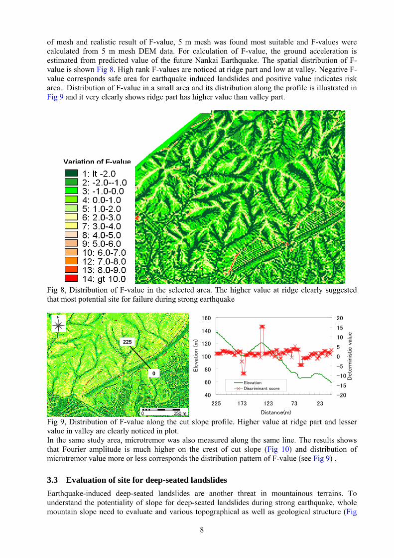
of mesh and realistic result of F-value, 5 m mesh was found most suitable and F-values were calculated from 5 m mesh DEM data. For calculation of F-value, the ground acceleration is estimated from predicted value of the future Nankai Earthquake. The spatial distribution of F-value is shown Fig 8. High rank F-values are noticed at ridge part and low at valley. Negative F-value corresponds safe area for earthquake induced landslides and positive value indicates risk area. Distribution of F-value in a small area and its distribution along the profile is illustrated in Fig 9 and it very clearly shows ridge part has higher value than valley part.
Fig 8, Distribution of F-value in the selected area. The higher value at ridge clearly suggested that most potential site for failure during strong earthquake
Fig 9, Distribution of F-value along the cut slope profile. Higher value at ridge part and lesser value in valley are clearly noticed in plot. In the same study area, microtremor was also measured along the same line. The results shows that Fourier amplitude is much higher on the crest of cut slope (Fig 10) and distribution of microtremor value more or less corresponds the distribution pattern of F-value (see Fig 9) .
3.3 Evaluation of site for deep-seated landslides
Earthquake-induced deep-seated landslides are another threat in mountainous terrains. To understand the potentiality of slope for deep-seated landslides during strong earthquake, whole mountain slope need to evaluate and various topographical as well as geological structure (Fig
225
0
225
0
40
60
80
100
120
140
160
225 173 123 73 23
Distance(m)
Ele
vation (m
)
-20
-15
-10
-5
0
5
10
15
20
Dete
rmin
istic v
alue
Elevation
Discriminant score
Variation of F-value

9
11) need to identify by the help of aerial photo interpretation, satellite image or relief map (as shown in Fig 7) prepared from DEM. First creep slope block is selected and F-value is determined to delineate fragile slope unit. Fig 11b illustrates risky block having toppled structure. F-value of this kind of toppled slope crest is always high and it is possible to delineate risky slope unit for earthquake-induced deep-seated landslides.
Fig 10, Microtremor measurement on the site and change of Fourier amplitude value as per the variation of topographical The stable and unstable large scale slope unit can be identified if morphology of slope is well understood. In Japan, old landslide terrain has typical morphology. The old landslide mass either extends from river bed to whole uphill slope (extended slope) or there is typical slope break (niche) at slope and relatively flat area (platform slope) can be seen on middle part of slope. Nepalese mountain slopes have also similar feature. These kinds of topographic features are shown in Fig 12a. In Japan, after study of many old landslide mass Inagaki et al. (2005) has demonstrate that (Fig 12b) the platform slope usually has higher factor of safety (stable) than extended slope (unstable). The extended slope usually has problem of toe undercutting and during strong earthquake, the slope is always vulnerable for large scale landsliding.
a. b.
c. d.

10
Fig 11, Typical topography and geological structures from by creep mass (after Chigira, 1992) and b. Toppled rock mass (photo courtesy: Wakio Suido) and probable position of high F-value.
Fig 12, a. Typical stable and unstable slope morphology in mountainous terrain and b. Stability of landslide topography (after Inagaki et al., 2005)
Location of high F-value b.
a. Topography Geological structures
b.
River valley
Old landslide mass
New landslide block
Unstable extended slope
a.
River valley
Old landslide mass
Stable platform slope
High F-value
Fac
tor
of s
afet
y (F
s)
Age of landslides (T), years
Factor of safety (Fs)
Regression line

11
4 CONCLUSIONS
In this paper, characteristic of earthquake-induced landslides is discussed and geomorphological approach of slope failure potential for earthquake-induced landslides is illustrated with some case studies. Analysis of potential location of earthquake-induced landslide is possible using the methodology described by Uchida et al. (2004) combined with GIS techniques. This study strongly recommend to consider the concept of seismic topographic amplification, which may ensue extensive damage in mountainous terrain from slope failure. The primary conclusion of this study is that precise DEM is adequate for the analysis of earthquake-induced shallow slope failure potential. In statistical analyses of landslide susceptibility, many intrinsic parameters are necessary (for example, geology, slope aspect, soil depth, soil type, land use, distance to road, distance to shore, distance to drainage, etc.), and data procurement can be extremely challenging. However, the method proposed by Uchida et al. (2004) requires only slope and curvature available from precisely-generated DEM data, and there is no need to consider any other intrinsic parameters. The maximum ground acceleration from earthquake shaking, which is site-specific, can be input as an approximation. The Nepal Himalaya is also very prone to big earthquake. Although, there is not any enough recorded data of earthquake-induced landslides in Nepal, the future risk could not be denied. There are some record of earthquake-induced landslides along the Dharan-Dhankuta Road after Eastern Nepal earthquake of 1988 (Zurick et al., 2005). During the strong earthquake period, Krinabhir (Prithivi Highway) type of topple failures will be common along the many stretch of Prithivi Highway and Mugling-Narayangadh Road. Therefore, this kind geomorphology based approach of earthquake-induced slope failure analysis could be an easier techniques to evaluates slopes of the Nepal Himalaya for regional scale planning.
5 ACKNOWLEDGEMENTS
We thank Mr. Toshiaki Nishimura and Ms. Seiko Tsuruta for their technical support during the preparation of this paper.
6 REFERENCES
Ambraseys N, Srbulov M (1995) Earthquake induced displacement of slopes. Soil Dyn. Earthqu. Eng. 14:59– 71
Bannister SC, Husebye ES, Ruud BO (1990) Teleseismic P coda analyzed by three-component and array techniques: deterministic location of topographic P-to-Rg scattering near the NORESS array, Bull. seism. Soc. Am. 80:1969-1986
Bouchon M, Schultz CA, Toksoz MN (1996) Effect of three-dimensional topography on seismic motion”, Journal of Geophysical Research 101(B3): 5835-5846
Capolongo D, Refice A, Mankelow J (2002) Evaluating earthquake-triggered landslide hazard at the basin scale through GIS in the upper Sele river valley, Surveys in Geophysics 23: 595–625
Carro M, De Amicis M, Luzi L, Marzorati S (2003) The application of predictive modeling techniques to landslides induced by earthquakes: the case study of the 26 September 1997 Umbria-Marche earthquake (Italy), Engineering Geology 69 (1-2):139-159
Chávez-García FJ, Sanchez LR, Hatzfeld D (1996) Topographic Site Effects and HVSR, A Comparison Between Observation and Theory, Bulletin of the Seismological Society of America 86(5):1559-1573
Chigira, M (1992) Long-term gravitational deformation of rocks by mass rock creep. Engineering Geology, 32, 157-184
Chiba T, Suzuki Y, Hiramatsu T (2007), Digital terrain representation method and red relief image Map, A new visualization Approach, Map – Journal of the Japan Cartographic Association 45-1, in Japanese with English abstract.
12
Chigira, M (1998) Geological prediction of rock avalanche. Proceedings of the 8th International Congress of International Association of Engineering Geology and Environment, Vancouver, Balkema, 1409-1414.
Chigira M, Yagi H (2006) Geological and geomorphological characteristics of landslides triggered by the 2004 Mid Niigta prefecture earthquake in Japan, Engineering Geology 82: 202-221
Chigira, M, Wang WN, Furuya T, Kamai T (2003) Geological causes and geomorphological precursors of theTsaoling landslide triggered by the 1999 Chi-Chi Earthquake, Taiwan. Engineering Geology 68: 259– 273
Clouser RH, Langston CA (1995) Modeling observed P-Rg conversions from isolated topographic feature near the NORESS array, Bull. Seism. Soc. Am. 85:195-211
Davis LL, West LR (1973) Observed effects of topography on ground motion. Bull. Selsm. Soc. Amer. 63:283-298
Gazetas G, Kallou PV, Psarropoulos PN (2002) Topography and soil effects in the MS 5.9 Parnitha (Athens) Earthquake: The case of Adámes, Natural Hazards 27: 133–169
Geli L, Bard PY, Jullien B (1988) The effect of topography on earthquake ground motion: a review and new results, Bulletin of the Seismological Society of America 78(1):42-63
Gilbert F, Knopoff L (1960) Seismic Scattering from Topographic irregularities, Journal of Geophysical Research 65: 3437-3444
Griffith DW, Bollinger GA (1979) The effect of Appalachian Mountain topography on seismic waves, Bull. Seis. Soc. Am. 69:1081-1105
Harp EL, Jibson RW (1996) Landslides triggered by the 1994 Northridge, California earthquake, Seismol. Soc. Am. Bull. 86(1B): S319–S332
Harp EL, Keefer DK (1990) Landslides triggered by the earthquake. In: Rymer MJ, Ellsworth, WL (eds) The Coalinga, California, earthquake of May 2, 1983, U.S. Geological Survey Professional Paper 1487: 335–347
Hasbaator, Hanaoka M, Nozawa E, Momose A, Sasaki K, (2006), Behaviour and mechanism of Earthquake-induced landslides within pre-existing landslide topography: the case of the 2004 mid-Niigata prefecture Earthquake, Japan. In: Marui H, Marutani T,Watanabe N, Kawabe H, Gonda Y, Kimura M, Ochiai H, Ogawa K, Fiebiger G, Heumader J, Rudolf-Miklau F, Kienholz H, Mikos M (Eds.), Proc. Interpraevent Int. Symp, Niigata 2006, Disaster mitigation of debris flow, slope failures and landslides, vol. 1. Universal Academy Press, Tokyo, pp 35–46.
Hasegawa S., Dahal R.K., Nishimura T., Nonomura A., Yamanaka M., 2008, DEM-Based Analysis of Earthquake-Induced Shallow Landslide Susceptibility, Geotechnical and Geological Engineering, Online first version, DOI: 10.1007/s10706-008-9242-z
Inagaki H, Ookuba T, Hasegawa S, Yatabe R (2005) Stability of old Landslides, Journal of Japan Geotechnical Engineering Society, 53(7): 17-19.
Jibson RW, Harp EL, Michael JA (1998) A method for producing digital probabilistic seismic
landslide hazard maps:An example from the Los Angeles, California Area, USGS Open-
File Rep: 98-113. Jibson RW, Harp EL, Michael JA (2000) A method for producing digital probabilistic seismic
landslid hazard maps. Engineering Geology 58:271– 290 Kawase H, Aki K (1988) Topography effect at the critical SV wave incidence: possible
explanation of damage pattern by to the Whittier-Narrows, California, earthquake of 1 October 1987, Bull. Seism. Soc. Am. 80:1-22
Keefer DK (1984) Landslides caused by earthquakes, Geol. Soc. Am. Bull. 95:406–421 Keefer DK (2000) Statistical analysis of an earthquake-induced landslide distribution – the 1989
Loma Prieta, California event, Engineering Geology 58(3-4): 231-249 Khazai B, Sitar N (2003) Evaluation of factors controlling earthquake-induced landslides caused
by Chi–Chi earthquake and comparison with the Northridge and Loma Prieta events. Eng Geol 71:79–95

13
Lin C-W, Shieh C-L, Yuan B-D, Shieh Y-C Liu S-H Lee S-Y (2003) Impact of Chi-Chi earthquake on the occurrence of landslides and debris flows: example from the Chenyulan River watershed, Nantou, Taiwan, Engineering Geology 71:49-61
Luzi L, Pergalani F (1996) Application of statistical and GIS techniques to slope instability zonation. Soil Dyn. Earthqu. Eng. 15(2): 83– 94
Luzi L, Pergalani F (2000) A correlation between slope failures and accelerometric parameters: the 26 September 1997 earthquake (Umbria– Marche, Italy). Soil Dyn. Earthqu. Eng. 20: 301–313
Mankelow JM, Murpy W (1998) Using GIS in the probabilistic assessment of earthquake triggered landslide hazards, Journal of Earthquake Engineering 2(4):593-623
Miles SB, Keefer DK (2000) Evaluation of seismic slope-performance models using a regional case study, Environmental & Engineering Geoscience, 6(1):25-39
Newmark NM (1965) Effects of Earthquake on Dams and Embankments, Geotechnique 15(2):139-159
Ohtsuki A, Harumi K (1983) Effect of topography and subsurface inhomogeneities on seismic SV waves, Journal of Earthquake Engineering & Structural Dynamics 11:441–462
Owen LA, Kamp U, Khattak GA, Harp EL, Keefer DK, Bauer MA (2008) Landslides triggered by the 8 October 2005 Kashmir earthquake, Geomorphology 94:1–9
Parise M, Jibson RW (2000) A seismic landslide susceptibility rating of geologic units based on analysis of characteristics of landslides triggered by the 17 January, 1994 Northridge, California earthquake, Eng. Geol. 58:251–270
Trifunac MD (1973) Analysis of strong earthquake ground motion for prediction of response spectra, Earthquake Eng. and Struct. Dynam. 2(1): 59-69
Uchida T, Kataoka S, Iwao T, Matsuo O, Terada H, Nakano Y, Sugiura N, Osanai N (2004) A study on methodology for assessing the potential of slope failures during earthquakes. Technical note of National Institute for Land and Infrastructure Management, p 91 (in Japanese with English summary)
Uchida T, Osanai N, Onoda S, Takayama T, Tomura K (2006) A simple method of producing probabilitic seismic shallow landslide hazard, In: Marui H, Marutani T,Watanabe N, Kawabe H, Gonda Y, Kimura M, Ochiai H, Ogawa K, Fiebiger G, Heumader J, Rudolf-Miklau F, Kienholz H, Mikos M (Eds.), Proc. Interpraevent Int. Symp, Niigata 2006, Disaster mitigation of debris flow, slope failures and landslides, vol. 2. Universal Academy Press, Tokyo, pp 529–534.
Umeda Y, Kuroiso A, Ito K, Ito Y, Saeki T (1986) High accelerations in the epicentral area of the Western Nagana Prefecture, Japan, Earthquake of 1984, J. Seism. Soc. Japan 39:217-228
Van Westen CJ, Terlien MTJ (1996) An Approach Towards Deterministic Landslide Hazard Analysis in GIS. A Case Study from Manizales(Colombia), Earth Surface Processes and Landforms 21:853-868
Wang HB, Sassa K, Xu WY (2007) Analysis of a spatial distribution of landslides triggered by the 2004 Chuetsu earthquakes of Niigata Prefecture, Japan, Nat Hazards 41:43–60
Wang WN, Nakamura H, Tsuchiya S, Chen CC (2002) Distributions of landslides triggered by the Chi-Chi earthquake in Central Taiwan on September 21, 1999, Journal of the Japan Landslide Society 38(4): 318–326
Wang WN, Wu HL, Nakamura H, Wu SC, Ouyang S, Yu MF (2003) Mass movements caused by recent tectonic activity: the 1999 Chi-Chi earthquake in central Taiwan, The Island Arc 12:325–334
Wilson RC, Keefer DK (1985) Predicting areal limits of earthquake-induced landsliding. In: Ziony JI (Ed.), Evaluating Earthquake Hazards in the Los Angeles Region - An Earth-science Perspective, US Geol. Surv. Prof. Paper 1360, pp 316–345
Zurick D, Pacheco J, Shrestha B, Bajracharya B (2005). Atlas of the Himalaya, International Centre for Integrated Mountain Development (ICIMOD), 96p.