
Geology of Vulcan Planum, Charon - USRA-Houston · Geology of Vulcan Planum, Charon Ross A....
2
Geology of Vulcan Planum, Charon Ross A. Beyer 1,2 , John R. Spencer 3 , William B. McKinnon 4 , Jeffrey Moore 2 , Stuart Robbins 3 , Paul Schenk 5 , Kelsi Singer 3 , Hal Weaver 6 , Leslie Young 3 , Kimberly Ennico 2 , Cathy Olkin 3 , Alan Stern 3 , and the New Horizons Science Team. 1 Carl Sagan Center at the SETI Institute, 2 NASA Ames Research Center, Moffett Field, CA, USA ([email protected]), 3 SwRI, 4 WUStL, 5 LPI, 6 JHU APL Charon has two large geologic provinces on the Pluto-facing hemisphere that New Horizons observed at high resolution [1]. The heavily tectonized areas of the northern regions are known as Oz Terra (this place- name and others in this abstract are informal) and Vulcan Planum is the large plain to the south. The border be- tween them strikes diagonally across the encounter hemi- sphere from as far south as -19 ◦ latitude in the west to 25 ◦ in the east (Figure 1). Both Vulcan Planum and Oz Terra have a similarly old age of ∼4 Ga [2, 3]. Vulcan Planum is vast, covering at least 540,000 km 2 , and its surface appears visually smoother when compared to the heavily tectonized surface of Oz Terra [1, 2]. Vulcan Planum contains craters, rilles, mountains, and other topographic features. It exhibits a variety of textures: definitely a smooth, lobate texture, but also a ridged/lineated texture in places, and pitted textures in others (Figure 2). A detailed map of features can be found in [4]. Rilles: Vulcan Planum is criss-crossed with a pattern of rilles [1, 2] which range from less than a kilometer to 3 km in width, and about half a kilometer in depth. They can be a few kilometers or hundreds in length. The rilles show an arcuate or sinuous pattern. In some locations they display an en echelon pattern. Some of the larger rilles have Y-shaped intersections. The larger rilles appear to preferentially parallel the strike of the Vulcan Planum/Oz Terra boundary, which parallels the dominant strike direction of nearby tectonic features in Oz Terra [5] and we will be performing a more detailed analysis of their strike. It isn’t clear if the align- ment of these rilles indicates a formation contemporane- ous with plains emplacement, or a process that occurred afterwards. Mountains: [1] and [2] described Vulcan Planum’s mountains. There are two large solitary massifs (But- ler and Kubrick Mons) and one cluster of three smaller peaks (Clarke Montes). Vulcan Planum does not onlap the toe of these mountains, but instead displays a con- vex, depressed margin which surrounds them, engender- ing the term ‘mountain in a moat’ for these features. Butler Mons is the largest, but by the time of closest approach it had set below the terminator. It can be seen in approach images which show substantial scarps to its east and south which may indicate a hitherto unknown southern boundary to Vulcan Planum. Kubrick Mons is also a single massif which measures 30 by 20 km in plan form and rises 3 km above the Vul- can Planum surface with a 1-km deep encircling moat. The surface of Kubrick is distinct from the rounded lo- bate shapes of Vulcan Planum which surround it. It dis- plays a ridge crest and other sharp-looking ridges that run down its flanks, with a similar appearance to slopes seen on Serenity Chasma to the north. The Clarke Montes is a trio of peaks that sit to- gether in a single, variable margin depression. They stand ∼1 km above the surrounding plain. The north- ern margin shows a 2 km drop from Vulcan Planum, but the western margin only 1 km, and the south and east do not have a distinct lobate margin but appear to smoothly grade out from the floor of the depression up to the plains. Margins: Everywhere along the south-facing bound- ary scarps of Oz Terra [5] which establish Vulcan Planum’s northern boundary, the surface of the planum is depressed a kilometer or more in elevation within about 20 km of the boundary. Where Vulcan Planum meets the scarps of Oz Terra, the Vulcan Planum units always appear to onlap the scarps, implying that the Vulcan Planum surface was em- placed after the scarps had been formed. In the portion of Vulcan Planum between Spock crater and where Serenity Chasma’s eastern end tran- sitions from a graben to a south-facing scarp, there is a well-resolved pattern of dense parallel rilles and ridges which parallel the boundary. This surface texture only appears away from the depressed margin where the planum materials are presumably thicker. Flow Features: We interpret the lobate, rounded fea- tures on Vulcan Planum to be the result of flow emplace- ment of the surface. The lobate margins which encir- cle the mountains appear to be the result of viscous flow which has encountered an obstacle. The depressed mar- gins along the Oz Terra scarps also imply a viscous flow, but the difference in width between the moats around the mountains and the depressed margin along the scarps may be due to the different depths of the viscous fluid in the center versus the potentially shallower depths at the margins. Further evidence for flow related to Vul- can Planum is a long tongue of smoother material which stretches into Oz Terra north from Alice crater [5]. 2679.pdf Lunar and Planetary Science XLVIII (2017)
Transcript of Geology of Vulcan Planum, Charon - USRA-Houston · Geology of Vulcan Planum, Charon Ross A....
Geology of Vulcan Planum, Charon Ross A. Beyer1,2, John R. Spencer3, William B. McKinnon4,Jeffrey Moore2, Stuart Robbins3, Paul Schenk5, Kelsi Singer3, Hal Weaver6, Leslie Young3, Kimberly Ennico2, CathyOlkin3, Alan Stern3, and the New Horizons Science Team. 1Carl Sagan Center at the SETI Institute, 2NASA AmesResearch Center, Moffett Field, CA, USA ([email protected]), 3SwRI, 4WUStL, 5LPI, 6JHU APL
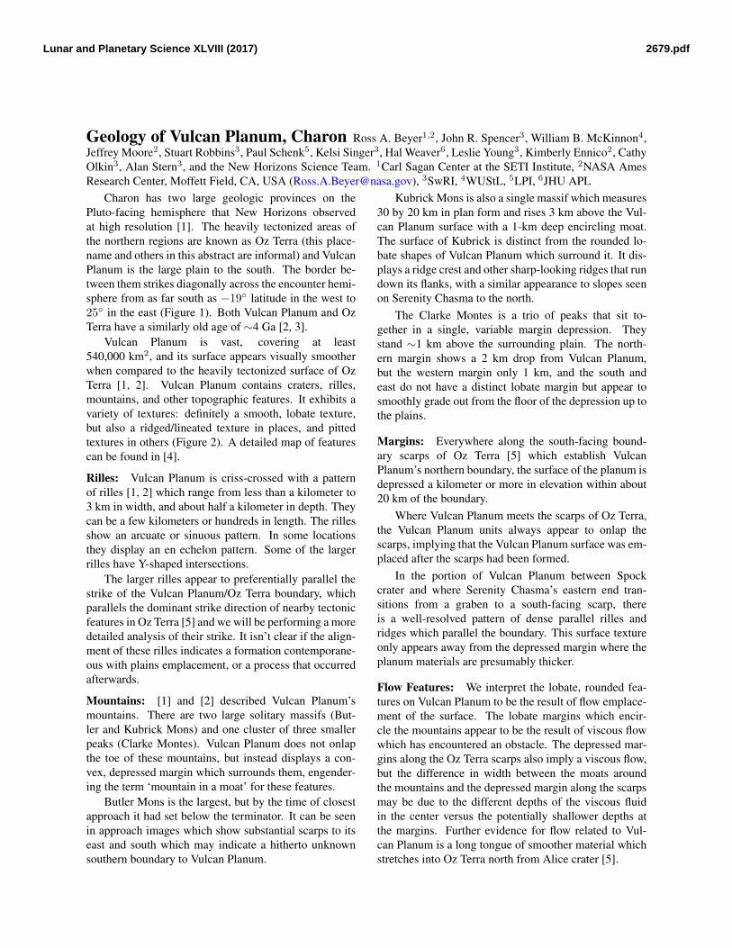
Charon has two large geologic provinces on thePluto-facing hemisphere that New Horizons observedat high resolution [1]. The heavily tectonized areas ofthe northern regions are known as Oz Terra (this place-name and others in this abstract are informal) and VulcanPlanum is the large plain to the south. The border be-tween them strikes diagonally across the encounter hemi-sphere from as far south as −19◦ latitude in the west to25◦ in the east (Figure 1). Both Vulcan Planum and OzTerra have a similarly old age of ∼4 Ga [2, 3].
Vulcan Planum is vast, covering at least540,000 km2, and its surface appears visually smootherwhen compared to the heavily tectonized surface of OzTerra [1, 2]. Vulcan Planum contains craters, rilles,mountains, and other topographic features. It exhibits avariety of textures: definitely a smooth, lobate texture,but also a ridged/lineated texture in places, and pittedtextures in others (Figure 2). A detailed map of featurescan be found in [4].
Rilles: Vulcan Planum is criss-crossed with a patternof rilles [1, 2] which range from less than a kilometer to3 km in width, and about half a kilometer in depth. Theycan be a few kilometers or hundreds in length. The rillesshow an arcuate or sinuous pattern. In some locationsthey display an en echelon pattern. Some of the largerrilles have Y-shaped intersections.
The larger rilles appear to preferentially parallel thestrike of the Vulcan Planum/Oz Terra boundary, whichparallels the dominant strike direction of nearby tectonicfeatures in Oz Terra [5] and we will be performing a moredetailed analysis of their strike. It isn’t clear if the align-ment of these rilles indicates a formation contemporane-ous with plains emplacement, or a process that occurredafterwards.
Mountains: [1] and [2] described Vulcan Planum’smountains. There are two large solitary massifs (But-ler and Kubrick Mons) and one cluster of three smallerpeaks (Clarke Montes). Vulcan Planum does not onlapthe toe of these mountains, but instead displays a con-vex, depressed margin which surrounds them, engender-ing the term ‘mountain in a moat’ for these features.
Butler Mons is the largest, but by the time of closestapproach it had set below the terminator. It can be seenin approach images which show substantial scarps to itseast and south which may indicate a hitherto unknownsouthern boundary to Vulcan Planum.
Kubrick Mons is also a single massif which measures30 by 20 km in plan form and rises 3 km above the Vul-can Planum surface with a 1-km deep encircling moat.The surface of Kubrick is distinct from the rounded lo-bate shapes of Vulcan Planum which surround it. It dis-plays a ridge crest and other sharp-looking ridges that rundown its flanks, with a similar appearance to slopes seenon Serenity Chasma to the north.
The Clarke Montes is a trio of peaks that sit to-gether in a single, variable margin depression. Theystand ∼1 km above the surrounding plain. The north-ern margin shows a 2 km drop from Vulcan Planum,but the western margin only 1 km, and the south andeast do not have a distinct lobate margin but appear tosmoothly grade out from the floor of the depression up tothe plains.
Margins: Everywhere along the south-facing bound-ary scarps of Oz Terra [5] which establish VulcanPlanum’s northern boundary, the surface of the planum isdepressed a kilometer or more in elevation within about20 km of the boundary.
Where Vulcan Planum meets the scarps of Oz Terra,the Vulcan Planum units always appear to onlap thescarps, implying that the Vulcan Planum surface was em-placed after the scarps had been formed.
In the portion of Vulcan Planum between Spockcrater and where Serenity Chasma’s eastern end tran-sitions from a graben to a south-facing scarp, thereis a well-resolved pattern of dense parallel rilles andridges which parallel the boundary. This surface textureonly appears away from the depressed margin where theplanum materials are presumably thicker.
Flow Features: We interpret the lobate, rounded fea-tures on Vulcan Planum to be the result of flow emplace-ment of the surface. The lobate margins which encir-cle the mountains appear to be the result of viscous flowwhich has encountered an obstacle. The depressed mar-gins along the Oz Terra scarps also imply a viscous flow,but the difference in width between the moats aroundthe mountains and the depressed margin along the scarpsmay be due to the different depths of the viscous fluidin the center versus the potentially shallower depths atthe margins. Further evidence for flow related to Vul-can Planum is a long tongue of smoother material whichstretches into Oz Terra north from Alice crater [5].
2679.pdfLunar and Planetary Science XLVIII (2017)

Figure 1: LORRI mosaic of Charon’s Vulcan Planum.
Figure 2: Portion of PELR C MVIC LORRI CA at157 m/pixel mosaic showing Vulcan Planum textures atthe highest resolution.
Conclusions: These observations of Vulcan Planumcontinue to support the conclusion that it is a cryovol-
canically emplaced unit [1, 2, 6], similar to that seen onAriel and Miranda [7] and other icy bodies in the solarsystem. The extent and age of resurfacing is comparableto that seen on saturnian and uranian satellites [6].
This work was supported by NASA’s New HorizonsProject.
References[1] S. A. Stern, et al. The Pluto system: Initial results from its
exploration by New Horizons. Science, 350(6258), 2015.doi:10.1126/science.aad1815.
[2] J. M. Moore, et al. The geology of Pluto and Charonthrough the eyes of New Horizons. Science, 351:1284–1293, 2016. doi:10.1126/science.aad7055.
[3] K. N. Singer, et al. Craters on Pluto and Charon – SurfaceAges and Impactor Populations. In Lunar and PlanetaryScience Conference, volume 47, page 2310. 2016.
[4] S. J. Robbins et al. Geologic map of New Horizons’ en-counter hemisphere of Charon, III. In Lunar and PlanetaryScience Conference, volume 48, page 1231. 2017.
[5] Ross A. Beyer, et al. Charon tectonics. Icarus, 2016. ISSN0019-1035. doi:10.1016/j.icarus.2016.12.018.
[6] J. R. Spencer, et al. Geology and Composition of Pluto andCharon from New Horizons. In AAS/Division for PlanetarySciences Meeting, volume 48, page 205.01. 2016.
[7] D. G. Jankowski and S. W. Squyres. Solid-state ice volcan-ism on the satellites of Uranus. Science, 241:1322–1325,1988. doi:10.1126/science.241.4871.1322.
2679.pdfLunar and Planetary Science XLVIII (2017)


![VULCAN HIGH SPEED DEEP FAT FRYER (ELECTRIC) › vulcan-website...Vulcan catering equipment (ptY)ltD [ 2 ] VULCAN HIGH SPEED DEEP FAT FRYER (ELECTRIC) GENERAL DATA: MANUFACTURER: Vulcan](https://static.fdocuments.in/doc/165x107/60c05ae5c355355f26327394/vulcan-high-speed-deep-fat-fryer-electric-a-vulcan-website-vulcan-catering.jpg)