Geology of the western Mexican Volcanic Belt and adjacent ...luca/334-04.pdf · Geological Society...
19
Geological Society of America Special Paper 334 1999 Geology of the western Mexican Volcanic Belt and adjacent Sierra Madre Occidental and Jalisco block Luca Ferrari Instituto de Geología, Universidad Nacional Autónoma de México, Apdo. Postal 70-276, Ciudad Univesitaria, 04510, México D.F., México. [email protected] Giorgio Pasquarè Dipartimento Scienze della Terra, Universitá degli studi di Milano,Via Mangiagalli 34, I-20133 Milano, Italy Saul Venegas-Salgado and Francisco Romero-Rios Comisión Federal de Electricidad, Gerencia Proyectos Geotermoelectricos, Departamento de Exploración, A. Volta 655, 58290 Morelia, Michoacan, México ABSTRACT The geology of a large portion of western Mexico, including the entire northern boundary of the Jalisco block, has been compiled at a regional scale. Revision of pre- vious works and new geological surveys allowed the construction of a 1:250,000 scale map with 28 informal geologic units, 25 for the Tertiary and Quaternary volcanic suc- cession of the Sierra Madre Occidental (SMO) and the Mexican Volcanic Belt (MVB). In this region, the MVB covers the boundary between the SMO volcanic province and the Cretaceous to Paleocene batholith and volcano-sedimentary sequences of the Jalisco block (JB). The 1000-m-thick succession of the SMO was emplaced during three discrete volcanic episodes of Eocene, Oligocene, and Early Miocene, separated by volcano-sedimentary deposits or unconformities. This succession, dominated by silicic ash flows, is absent in the deep geothermal wells of La Primavera, San Marcos and Ceboruco areas, indicating that the southern boundary of the SMO is located north of these sites. Within most of the study area, the MVB is clearly separated from the SMO by a tectonic unconformity produced in Middle Miocene. The first episode belonging to the MVB is represented by a widespread and volumetrically significant mafic volcanism, sometimes with an alkaline composition, which occurred at 11–8 Ma in central-eastern Nayarit and in the Guadalajara region. A period of reduced volcanic activity between 7.2 Ma and 5.5 Ma was followed by the emplacement of large volumes of rhyolites and minor ignimbrites in Early Pliocene. Intermediate to mafic volcanism, also with alkaline composition, becomes again dominant between ~4.5 Ma and the Present, although large rhyolitic and dacitic dome complexes were emplaced between Guadalajara and Tepic. In Late Pliocene and Quaternary times, large andesitic to dacitic strato-volcanoes were built in the northern part of the arc, whereas basaltic shield volcanoes and cinder cones characterize the volcanic front. Ferrari, L., Pasquarè, G., Venegas-Salgado, S., and Romero-Rios, F., 1999, Geology of the western Mexican Volcanic Belt and adjacent Sierra Madre Occidental and Jalisco block, in Delgado-Granados, H., Aguirre-Díaz, G., and Stock, J. M., eds., Cenozoic Tectonics and Volcanism of Mexico: Boulder, Colorado, Geological Society of America Special Paper 334. 65
Transcript of Geology of the western Mexican Volcanic Belt and adjacent ...luca/334-04.pdf · Geological Society...

Geological Society of AmericaSpecial Paper 334
1999
Geology of the western Mexican Volcanic Belt and adjacent Sierra Madre Occidental and Jalisco block
Luca FerrariInstituto de Geología, Universidad Nacional Autónoma de México, Apdo. Postal 70-276,
Ciudad Univesitaria, 04510, México D.F., México. [email protected] Pasquarè
Dipartimento Scienze della Terra, Universitá degli studi di Milano, Via Mangiagalli 34, I-20133 Milano, ItalySaul Venegas-Salgado and Francisco Romero-Rios
Comisión Federal de Electricidad, Gerencia Proyectos Geotermoelectricos,Departamento de Exploración, A. Volta 655, 58290 Morelia, Michoacan, México
ABSTRACT
The geology of a large portion of western Mexico, including the entire northernboundary of the Jalisco block, has been compiled at a regional scale. Revision of pre-vious works and new geological surveys allowed the construction of a 1:250,000 scalemap with 28 informal geologic units, 25 for the Tertiary and Quaternary volcanic suc-cession of the Sierra Madre Occidental (SMO) and the Mexican Volcanic Belt (MVB).
In this region, the MVB covers the boundary between the SMO volcanic provinceand the Cretaceous to Paleocene batholith and volcano-sedimentary sequences of theJalisco block (JB). The 1000-m-thick succession of the SMO was emplaced duringthree discrete volcanic episodes of Eocene, Oligocene, and Early Miocene, separated byvolcano-sedimentary deposits or unconformities. This succession, dominated by silicicash flows, is absent in the deep geothermal wells of La Primavera, San Marcos andCeboruco areas, indicating that the southern boundary of the SMO is located north ofthese sites.
Within most of the study area, the MVB is clearly separated from the SMO by atectonic unconformity produced in Middle Miocene. The first episode belonging to theMVB is represented by a widespread and volumetrically significant mafic volcanism,sometimes with an alkaline composition, which occurred at 11–8 Ma in central-easternNayarit and in the Guadalajara region. A period of reduced volcanic activity between7.2 Ma and 5.5 Ma was followed by the emplacement of large volumes of rhyolites andminor ignimbrites in Early Pliocene. Intermediate to mafic volcanism, also with alkalinecomposition, becomes again dominant between ~4.5 Ma and the Present, although largerhyolitic and dacitic dome complexes were emplaced between Guadalajara and Tepic.In Late Pliocene and Quaternary times, large andesitic to dacitic strato-volcanoes werebuilt in the northern part of the arc, whereas basaltic shield volcanoes and cinder conescharacterize the volcanic front.
Ferrari, L., Pasquarè, G., Venegas-Salgado, S., and Romero-Rios, F., 1999, Geology of the western Mexican Volcanic Belt and adjacent Sierra MadreOccidental and Jalisco block,in Delgado-Granados, H., Aguirre-Díaz, G., and Stock, J. M., eds., Cenozoic Tectonics and Volcanism of Mexico: Boulder,Colorado, Geological Society of America Special Paper 334.
65

INTRODUCTION
Purpose and limitations of this work
The aim of this work was to produce a geologic map of south-western Mexico between the Pacific coast and the city of Guadala-jara, which could constitute a useful framework for studies on thetectonic evolution of the Gulf of California and the Jalisco block.This region includes the Tepic-Zacoalco rift (TZR), thought to rep-resent the northern boundary of the Jalisco block incipientmicroplate (Luhr et al., 1985; Allan et al., 1991), and the westernsector of the Mexican Volcanic Belt (MVB), where alkaline (oceantype) and calc-alkaline volcanism have been occurring in closeassociation since Late Miocene time (Wallace et al., 1992; Mooreet al., 1994) (Fig. 1). Just north of the MVB is also the southerntermination of the Sierra Madre Occidental silicic volcanic prov-ince (Fig. 1), which has been affected by various phases of Basinand Range extension and strike-slip deformation since the EarlyMiocene (Henry and Aranda-Gomez, 1992; Ferrari, 1995; Nieto-
Samaniego et al., 1999). The MVB itself is thought to conceal thetectonic boundary between different tectonostratigraphic terranes(Sedlock et al., 1993) which underwent hundreds of kilometers ofstrike-slip displacement in Mesozoic to earliest Tertiary times(Gastil and Jensky, 1973; Anderson and Schmidt, 1983).
Because of this volcanic and structural complexity, this regionhas probably received as much attention as the rest of Mexico in thelast ten years, yet the map of west-central Nayarit by Gastil et al.(1978) provides the only complete geologic study of at least half ofthe region. Other geologic works are concerned with smaller areas(Demant, 1979; Nieto-Obregon et al., 1985; Gilbert et al., 1985;Allan, 1986; Nixon et al., 1987; Wallace and Carmichael, 1989;Lange and Carmichael, 1991; Delgado-Granados, 1992; Quinteroet al., 1992; Righter and Carmichael, 1992; Michaud et al., 1993;Ferrari et al., 1994a, 1997; Moore et al., 1994; Righter et al., 1995;Rosas-Elguera et al., 1997), or deal only with late Pliocene-Quater-nary volcanic centers (Luhr and Carmichael, 1980, 1981, 1982;Mahood, 1980; Nelson, 1980; Luhr and Lazaar, 1985; Nelson andLivieres, 1986; Nelson and Hegre, 1990).
66 L. Ferrari et al.
Figure 1. Geodynamic sketch of Mexico depicting the four main plates and the Eocene to Present subduction-related volcanic arcs.JB = Jalisco block. Boundaries of Mexican Volcanic Belt and Sierra Madre Occidental in central Mexico from Ferrari et al. (1994a).

A geologic and stratigraphic framework for this region wasparticularly needed in order to reconstruct properly its tectonicevolution, as there was no agreement about the recent and activestructures forming the TZR (Nieto-Obregon et al., 1985; Barrieret al., 1990; Michaud et al., 1991; Allan et al., 1991; Rosas-Elguera et al., 1993; Ferrari et al., 1994a). On the other hand theGeothermal Division of Comisiòn Federal de Electricidad (CFE)has been exploring several areas in the region since the late sev-enties in cooperation with the second author and also felt thenecessity of organizing its unpublished data into a wider geologicframework. The project of the map was thus initiated in 1992 as acooperative effort between the first author and CFE to integratetheir unpublished data with new geologic survey and to elaboratethem into unique regional stratigraphy.
Previous published and unpublished data were revised andcompiled at a scale of 1:100,000. Areas without geologic informa-tion were mapped at a scale of 1:50,000 scale during a total of fivemonths of field work between 1992 and 1993. The final map(Plate 1, see inside back cover) was then compiled at a scale of1:250,000 and stored in an electronic format. The extremely pooraccess prevented a detailed survey of the northeastern and south-western parts of the studied region. These areas were examined ata reconnaissance level along existing roads and through two heli-copter flights and then mapped mostly by aerial photographs. Fig-ure 2 shows the degree of detail of the geologic informationprovided by the map.
All geological units we have established are informal; whenalready present in the geological literature, we try to maintainformal or informal names. We group rocks according to their ageand to the presence of a first order bounding unconformity. Vol-canic rocks of the same age were subdivided also according totheir lithology, chemical composition and type of volcanic center.As the map is mainly addressed to the Late Tertiary and Quater-nary geologic evolution the stratigraphy and the tectonics of pre-Late Tertiary rocks is greatly simplified. In some cases, thePlio-Quaternary stratigraphy may be perhaps oversimplified aswell, but this is due to the uneven detail of the geologic knowl-edge over the region.
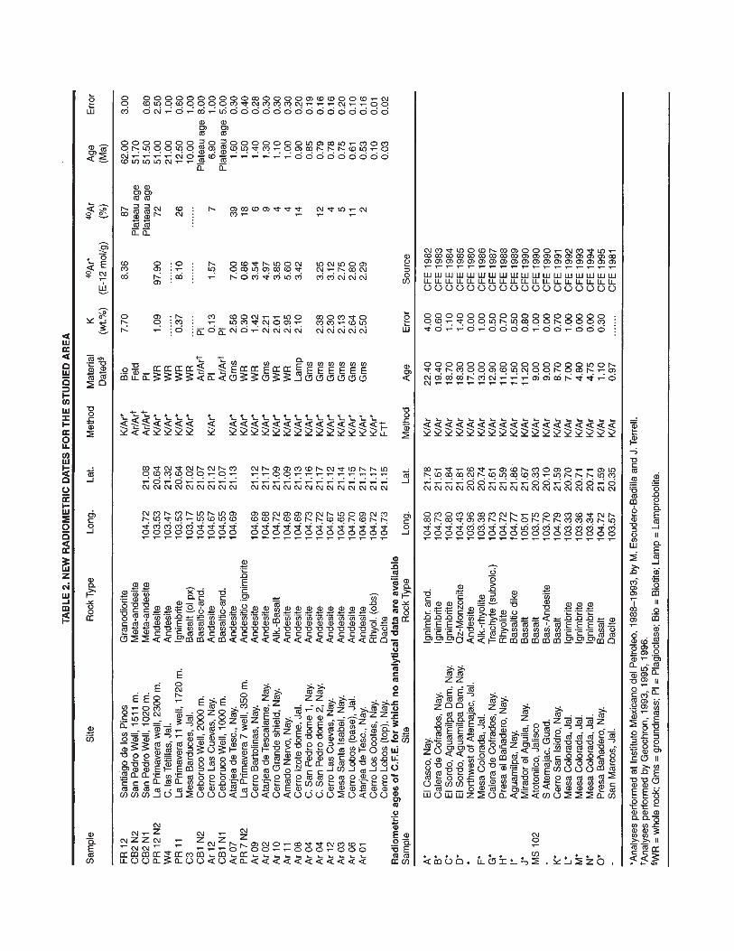
The regional stratigraphy elaborated in this work was sup-ported by a total of 260 radiometric ages compiled from the lit-erature (Table 1) or published here for the first time (Table 2).Although relevant in number, these ages are often concentratedin areas of economic or scientific interest, so that the stratigra-phy of some parts of the studied region still lack good geo-chronologic control. The ages reported in Table 1 and 2 aregenerally consistent with the stratigraphic setting of the rela-tive samples.
We have tried to incorporate all existing data in the map; inaddition, the use of an electronic storage system will permit us tomodify and integrate the map easily in the future. We considerthe map to be a first attempt to provide a regional geologic frame.We hope to stimulate more detailed mapping as well as newstratigraphic and geochronologic studies, which surely willimprove our work.
REGIONAL STRATIGRAPHY
The region presents a stratigraphic succession which includesthe Cordilleran basement, the Oligocene to middle Miocene SMOvolcanics and the Late Miocene to Quaternary MVB sequence. Inthe following section, we briefly review the geologic units used inthe map but we refer to the existing literature for a more comprehen-sive description. Some details are given only for units not describedpreviously. The Neogene tectonics of the studied area is analyzed ina companion paper (Ferrari and Rosas, this volume), in Ferrari(1995), Ferrari et al. (1997) and in Rosas-Elguera et al. (1996).
Jalisco block
The JB is a distinctive tectono-stratigraphic assemblage consist-ing of Late Cretaceous to Early Tertiary volcanic and volcaniclasticdeposits and marine sedimentary sequences (unit 1 and 3) intrudedby granitoid plutons (unit 2). These rocks are often involved in low-to medium-grade metamorphism increasing from the southeast tothe northwest and are affected by folding and faulting, likely relatedto the Laramide orogenesis. Turbiditic sequences are often interca-lated with the volcanic rocks but are dominant in the western JB(Sierra Vallejo and Sierra de Zapotan). Volcanic rocks are rhyoliticash flow tuff and subordinate andesites, mainly exposed in the cen-tral part of the area (Sierra Guamuchil and Sierra Jolapa). Limestoneand minor sandstone of probable Mesozoic age are confined to thesoutheastern part of the area, just west of Atemajac.
The ages of the volcanic rocks exposed in the JB range from114 Ma to 52 Ma (Gastil et al., 1978; Wallace and Carmichael,1989; Lange and Carmichael, 1991; Righter et al., 1995; Rosas-Elguera et al., 1997) with a cluster of 39Ar/40Ar ages between60 Ma and 80 Ma (Righter et al., 1995). Plutonic rocks consists ofgranite, granodiorite, and tonalite which form a large singlebatholith south of Puerto Vallarta and probably represent the base-ment of the whole JB. Their apparent ages range between 108 Maand 45 Ma (Gastil et al., 1978; Allan, 1986; Köhler et al., 1988;Zimmermann et al., 1988). According to the ages obtained withdifferent methods and/or on various minerals Zimmermann et al.(1988) suggest two main periods of emplacements at ~105 Maand ~65 Ma with cooling ages up to 20 Ma younger. Zircon U-Pbdates and Rb-Sr isochrons, however, indicate ages of emplace-ment ranging between ~100 and 90 Ma (Schaaf et al., 1993).Based on close similarity in ages and chemical and isotope com-position, Böhnel et al. (1992) demonstrated that the PuertoVallarta batholith is equivalent to the Los Cabos batholith (BajaCalifornia Sur). In summary, the plutonic and volcanic rocks ofthe JB are part of the same Late Cretaceous–Early Tertiary mag-matic arc which have been recognized southeastward along theGuerrero terrane (Campa and Coney, 1983; Sedlock et al., 1993).
Sierra Madre Occidental volcanic province.
The SMO is a huge, middle Tertiary, volcanic province whichextends from the southwestern United States to central Mexico
Geology of the western Mexican Volcanic Belt and adjacent Sierra Madre Occidental and Jalisco Block67

Figure 2. a) Credits ofthe geologic survey.b) Level of detail ofthe geologic map.


(Fig. 1). In its northern part the SMO is composed of silicic ash flowtuffs and rhyolitic lavas with minor amounts of andesitic lavas. Theiraverage thickness exceed 1 km (McDowell and Clabaugh, 1979) andthe ages cluster in two discrete periods of Eocene and Oligocene age(Montigny et al. 1987 and references therein; Aguirre-Díaz andMcDowell, 1991 and reference therein). This silicic volcanism islargely the result of fractional crystallization of mantle-derivedbasalts produced by the subduction of the Farallon plate (Johnson,1991; Wark, 1991) and the volcanic activity appears contemporary tothe waning of compression which followed the Laramide orogenesisand with the first part of Basin and Range extension (Wark et al.,1990; Aguirre-Diaz and McDowell, 1991, 1993).
The study area encompasses the southernmost part of SMOwhich exhibits a stratigraphy mostly similar to the northern partof the province (Nieto-Samaniego et al., 1999). The existence ofa pre-volcanic (Cretaceous?) basement is substantiated by local-ized outcrops of argillite and limestone (not mapable at the scaleof Plate 1) which were exposed along the lower part of the RioGrande de Santiago canyon before the construction of theAguamilpa reservoir. The spatial association of these rocks withLate Oligocene to Early Miocene granite to granodiorite stocks(Gastil et al., 1978; Nieto-Obregon et al., 1985)(unit 6) suggestthat they were roof pendants uplifted by the plutons. AlthoughEocene rocks are reported by Webber et al. (1994) about 50 kmnortheast of San Cristobal and in the central SMO in Durango(Aguirre-Díaz and McDowell, 1991), no pre-Oligocene volcanicrocks were found in the study region.
The most widespread unit in the southern SMO is a successionof welded ash flow tuffs and minor andesitic lava flows (unit 4)which attains an aggregate thickness of 800 m in the southeasternpart of the area (Fig. 3). Oligocene ash flows (34–28 Ma; Damonet al., 1979; Nieto-Obregon et al., 1981) are found in the SantaMaria del Oro and Juchipila areas (Fig. 3 and 4). In the western partof the area these rocks are interbedded with and capped by volcano-clastic sequences made of clay, sandstone and conglomerate.Although this sequence was not encountered in the northeastern partof the study area, Spinnler et al. (this volume) recognized an angu-lar unconformity within the ignimbritic succession. Most of theSMO, however, is covered by rhyolitic ash flow and pumice-flowand minor domes with ages of 26–17 Ma (Damon et al., 1979;Gastil et al., 1978; Nieto-Obregon et al., 1981, 1985; Scheubel et al.,1988; Moore et al., 1994; Webber et al., 1994; Nieto-Samaniegoet al., 1999) which are only found in the southern SMO. Ash flowsand rhyolites with similar ages exposed in southernmost Baja Cali-fornia (Hausback, 1984) and as far as 230 km east of Guadalajara(Pasquarè et al., 1991; Tuta et al., 1988) may represent respectivelythe front and the back arc of the Early Miocene SMO.
Between San Cristobal and García de la Cadena a successionof basaltic-andesitic lava flows is found capping the EarlyMiocene ash flows (Unit 5). This succession yielded ages com-prised between of 21.8 and 19 Ma (Nieto-Obregon et al., 1981;Moore et al., 1994; Ferrari and Lopez-Martinez unpublished data)and has geochemical characteristics (Moore et al., 1994) correla-tive with the Southern Cordillera Basaltic Andesite (SCORBA)
first studied in Chihuahua by Cameron et al. (1989) and alsoreported in central Durango (Aguirre-Díaz and McDowell, 1993).
North of Guadalajara the SMO succession is dissected bynorth-south to north-northeast–southsouth-west trending, ~15 kmwide grabens (Nieto-Samaniego et al., 1999). One of this grabens,the Juchipila graben, is floored by a stratified volcano-sedimen-tary succession (unit 8). This consists of some meter of a coarsevolcanic conglomerate, followed by up to 250 m of lacustrineclays, silts and limestones.
In the eastern part of the study area, north of Santa Maria delOro, the SMO ash flows are sometimes covered by erodedandesitic volcanoes which in one case has been dated 14.7 Ma(Rodriguez-Castaneda and Rodriguez-Torres, 1992). South ofTepic, a succession of andesitic and basaltic flows with subordi-nate rhyolites gave ages comprised between 20.4 and 13.8(± 3.1) Ma (Gastil et al., 1979a). These rocks (unit 7)suggest theexistence of a middle Miocene volcanic arc shifted in the westernpart of the SMO province and characterized by products of inter-mediate composition. We believe that this volcanism representsthe southern occurrence of the Early to Middle Miocene andesiticarc recognized by Gastil et al. (1979b) and Fenby and Gastil(1991) around the Gulf of California which was subsequentlyseparated along its axis by the opening of the gulf itself.
Mexican Volcanic Belt
The Mexican Volcanic Belt (MVB) is a 1000-km-long vol-canic arc formed in response to the subduction along the Aca-pulco trench since middle Miocene (Ferrari et al., 1994b; 1999)(Fig. 1). The western MVB has been often regarded as mainlyPlio-Quaternary in age (Nelson and Sanchez-Rubio, 1986; Nixonet al., 1987) but a large amount of mafic lavas were alsoemplaced in Miocene time. The older rocks are exposed along thenorthwestern shores of the Chapala lake, in the Sierra Las Vigas(unit 9). They are volcanic breccias made of decimetric to metricclasts of andesitic to dacitic composition sometimes supported bya sandy matrix (Garduño et al., 1993). These rocks are oftenhighly altered by hydrothermal processes and fractured. Thereare no ages available for these rocks but they must be pre-LateMiocene because of their stratigraphic position.
In the Guadalajara region, a monotonous sequence of thinbasaltic lava flows is exposed all along the Rio Santiago east ofTequila (unit 10). This succession yielded ages of 10.2–8.5 Ma(Table 1) (Fig. 3) and the composition tend to evolve upsectionfrom alkali-basalts to basaltic andesites (Moore et al., 1994).Individual flows range between 2 and 10 m in thickness and theexposed succession is over 600 m thick. A distinctive silicicwelded ash flow (Inversely Welded Tuff of Moore et al., 1994) isinterbedded with the basalts in the lowest part of the exposed suc-cession and a heterogeneous silicic succession made of pumiceflows, welded ash flows, ash falls and reworked pyroclastics (LosCaballos tuff of Moore et al., 1994) overlies the basalts both tothe north and to the south of San Cristobal. North of Tequila, thebasalts rest in unconformity above folded ash flows of the SMO
Geology of the western Mexican Volcanic Belt and adjacent Sierra Madre Occidental and Jalisco Block73

(Ferrari et al., 1997). In the San Cristobal area the basal contact isnever exposed at the 800 m elevation of the Rio Santiago base,but ash flows belonging to the SMO outcrop at an average eleva-tion of 2000 m just 25 km north of San Cristobal. Thus the basaltsprobably flowed southward into a preexisting depression cut intothe SMO sequence. Several eroded basaltic shield volcanoes areactually exposed north of Rio Santiago, resting on Early Mioceneash flows. One of these centers has been dated 11 Ma (Mooreet al., 1994), and the others probably have similar ages since theirflows join with the San Cristobal plateau.
South of Rio Santiago, the basalts are covered by youngerrocks but, about 35 km south of San Cristobal the geothermal
wells drilled in the La Primavera caldera encountered a monoto-nous sequence over 800 m thick of basaltic and basaltic-andesitic flows under about 1100 m of ash flows, rhyolites, andlacustrine deposits correlative with the Pio-Quaternary succes-sion (Fig. 5). These basalts are both aphyric and porphiritic withphenocrysts of plagioclase and olivine and, sometimes, a glassytexture in the groundmass. A glassy rhyolitic ash flow is alsointercalated in the central part of the basaltic succession. Thissuccession shows a very similar petrography and stratigraphywith respect to the one exposed in the San Cristobal area and awhole rock age of 12.5 ± 0.6 Ma has been obtained for a basaltic-andesite at the base of the succession (Table 2, Fig. 5). The San
74 L. Ferrari et al.
Figure 3. Composite stratigraphic columns for thenortheastern part of the mapped area at the longi-tude of Guadalajara. The first column refers to theSMO succession exposed north of Rio Santiago.The second column refers to the succession exposedin the Rio Santiago valley between San Cristobaland the Santa Rosa dam. At San Cristobal, only theMVB succession is exposed. Volcanic rocks belong-ing to the MVB filled a basin (symbolized by thedashed line), cut into the SMO succession, which isexposed in the Santa Rosa dam area. Number to theleft of columns are unit thickness in m. Absoluteages from Nieto-Obregon et al. (1981, 1985),Gilbert et al. (1985), Moore et al. (1994) and thiswork are also reported in Table 1 and 2.

Cristobal plateau extends also east of Guadalajara for over130 km with an average thickness of 200 m and ages comprisedbetween 11 and 8 Ma (Ferrari et al., 1994c; 1999). As a conse-quence, the Late Miocene basalts of the Guadalajara regioncover an area comparable to that of the Late Pliocene-Quater-nary Michoacan-Guanajuato volcanic field (Hasenaka andCarmichael, 1985), and their volume exceeds the total volcanicoutput of the western MVB during the Pliocene and Quaternary(Ferrari unpublished data). Thus the Late Miocene volcanismrepresents a major stage in the building of the MVB.
About 160 km west of Guadalajara, a plateau of alkali-basaltswith ages between 11 and 8.9 Ma (Righter et al., 1995; Table 2) isexposed between the SMO and the Pacific coast north of Tepic(unit 11) (Fig. 4). The lavas are nearly aphyric with micropheno-cryts of olivine and minor plagioclase. These rocks rest in uncon-formity above tilted blocks of the SMO. Several mafic dikes withages of 12–11 Ma (Damon et al., 1979; Clark et al., 1981; Table 2)and north-south to north-northwest trend are found the westernpart of the SMO. Basaltic lavas and north-northeast trending dikesof the same age are also found along the southern coast of Nayarit,north of Punta Mita. In this area, many of the basalts were emplaced
as pillow lava. In addition, Gastil et al. (1979b) reported foram-bearing volcanic sandstones interbedded with basalts dated10 Ma, which testify that marine ingression related to the “Proto-gulf opening” was already underway by this time.
A very thick succession of mafic lava flows of Late Mioceneage has been also found in the deep geothermal well drilled 3 kmsouth of the crater of the Ceboruco volcano by CFE (CB1 well,Fig. 5a). This succession, composed by microporphyritic toaphyric basalts and basaltic-andesites with minor intercalationsof pumice and ash flows, rests directly over altered ignimbritesand andesites correlative with the Jalisco block successionexposed 10 km to the south.
The volcanic succession in the Chapala lake region is morecomplex and has been studied in less detail. Rocks to the southand the west of the Chapala lake are lava flows and breccias ofLate Miocene to Early Pliocene age (unit 12). In the Sierra deTapalpa, most of the succession consists of alkaline basaltic andandesitic lava flows with ages comprised between 5.4 and 4.4 Ma(Allan, 1986) although Late Miocene lavas are also reported(Rosas-Elguera et al., 1997) (Table 2). The succession exposedto the north and the west of the Chapala lake comprise also silicic
Geology of the western Mexican Volcanic Belt and adjacent Sierra Madre Occidental and Jalisco Block75
Figure 4. Composite stratigraphic columns for the westernpart of the mapped area. The first column includes rockscropping out in the Rio Santiago valley between Sierra Alicaand Tepic. The second column shows the stratigraphyexposed in southwestern Nayarit along the western edge ofthe Jalisco block. Absolute ages from Gastil et al. (1978,1979b), Damon et al. (1979), Zimmermann et al. (1988),Rodriguez-Castaneda and Rodriguez-Torres (1992), Righteret al. (1995), and this work are also reported in Table 1 and 2.

Figure 5. Stratigraphy of deep geothermal well drilled by CFE in the Ceboruco area (a) and in the La Primavera and San Marcos areas (b). Absoluteelevation (asl) is indicated on the left of the column. Thicknesses for the units encountered in the La Primavera caldera are averages of data from 10wells. All but one well (PR 9) stopped before 450 m bsl. Absolute age for the CB2 well from this work (Table 2).
lavas and welded ash flows with ages ranging between 6.7 and4.2 Ma (Delgado-Granados, 1992) (unit 13). Locally, deltaic andlacustrine deposits including diatomitic facies (unit 14) areinterbedded in the previous successions. These deposits consistmainly of reworked silicic ash fall and lavas and are related to theinitial formation of the Chapala lake.
In the Guadalajara area, the Late Miocene basalts are cov-ered by the Cerro La Col and Cerro Los Bailadores rhyoliticdome complexes (5.5–5.2 Ma) and by various silicic ash flowsand air fall deposits among which are the 4.7 Ma San GasparIgnimbrite and the 3.3 Ma Guadalajara Ignimbrite (Gilbert et al.,1985) (unit 15). As a whole this silicic succession is up to 800 mthick and correlative rocks have been found in the La Primavera
wells (Fig. 5b). A similar silicic sequence is exposed in the Sierrade Ahuisculco (unit 16), where an ignimbrite yielded an age of4.7 Ma (Rosas-Elguera et al., 1997), suggesting a possible corre-lation of this succession with the Guadalajara group.
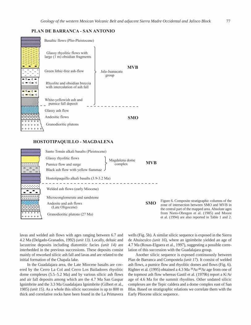
Another silicic sequence is exposed continuously betweenPlan de Barranca and Compostela (unit 17). It consist of weldedash flows, a pumice flow and rhyolitic domes and flows (Fig. 6).Righter et al. (1995) obtained a 4.3 Ma 39Ar/40Ar age from one ofthe topmost ash flow whereas Gastil et al. (1979b) report a K/Arage of 4.6 Ma for the summit rhyolites. Other undated siliciccomplexes are the Tepic caldera and a dome complex east of SanBlas. Based on stratigraphic relations we correlate them with theEarly Pliocene silicic sequence.
Geology of the western Mexican Volcanic Belt and adjacent Sierra Madre Occidental and Jalisco Block77
Figure 6. Composite stratigraphic columns of thezone of intersection between SMO and MVB inthe central part of the mapped area. Absolute agesfrom Nieto-Obregon et al. (1985) and Mooreet al. (1994) are also reported in Table 1 and 2.
The Plio-Quaternary MVB consists mostly of basaltic cindercones and shield volcanoes, andesitic to dacitic stratovolcanoesand dacitic to rhyolitic domes (Nixon et al., 1987 and referencestherein; Wallace and Carmichael, 1989; Lange and Carmichael,1991; Wallace and Carmichael, 1994; Righter and Carmichael,1992; Moore et al., 1994; Righter et al., 1995). Lava types areboth alkaline and calc-alkaline in composition and fall in theocean island and subduction related fields (Righter and Car-michael, 1992; Moore et al., 1994; Righter et al., 1995), althoughthe former are subordinated in volume. Basaltic lavas with oce-anic island affinity occur all over the western MVB but seem con-centrated in the northern part of the arc (unit 18 and 22). In theGuadalajara and Hostotipaquillo areas, a peculiar variety of EarlyPliocene porphyritic olivine-basalts with megacrysts of plagio-clase are found within this group (Moore et al., 1994) but the restof these rocks are microporphyritic to aphyric. Subduction-related basalts and andesites are found in close association withthe OIB-type volcanics. Calc-alkaline and alkaline basaltic cindercones and shield volcanoes of Early Pliocene to Holocene ageunconformably cover the JB and constitute the volcanic front ofthe western MVB (Wallace and Carmichael, 1989; Lange andCarmichael, 1990; Righter and Carmichael, 1992) (unit 19band 23). Late Pliocene and Quaternary andesitic to dacitic strato-volcanoes are located mostly at the rear of the arc (Luhr andCarmichael, 1980, 1981, 1982; Nelson, 1980; Wallace andCarmichael, 1994; Nelson and Livieres, 1986) (unit 19a and 24).Late Pliocene to Quaternary silicic volcanism is restricted to theMagdalena and San Pedro (Castillo and De la Cruz, 1992,Table 2) rhyolitic and dacitic dome complexes and the Las Nava-jas (Nelson and Hegre, 1990) and La Primavera (Mahood, 1980,1981) peralkaline rhyolitic centers (unit 25 and 26). The Quater-nary Acatlán ignimbrite, described by Wright and Walker (1981),is exposed in the southern part of the mapped area (unit 21). It iscovered by a basaltic flow dated at 0.65 Ma (Allan, 1986) and isprobably related to rhyolitic domes located north of Acatlàn(Ferrari et al., 1997).
Several fluvio-lacustrine deposits crop out at the base of thetectonic depressions inside the JB (unit 20) and are presentlyundergoing erosion. In the Puerto Vallarta and Amatlàn de Cañasdepressions, they are represented by a poorly cemented con-glomerate with clasts of granite supported in a sandy matrix. Inthe Ameca area, volcano-lacustrine deposits are also presentwithin this unit. All these deposits are probably related to theEarly Pliocene formation of these tectonic depressions.
DISCUSSION AND CONCLUSIONS
The boundary between the Jalisco block and theSierra Madre Occidental
The regional mapping presented in Plate 1 allows us to inferthe location of the northern boundary of the JB and to discuss itsnature. The ages of plutonic and volcanic rocks to the north andto the south of the western MVB indicate that the boundary
between JB and SMO is concealed beneath Late Miocene toQuaternary volcanic rocks. The northernmost exposure of Creta-ceous-Paleocene ash flow and granitoids are south of Volcán SanJuan, in the Sierra El Guamuchil and Sierra de Ameca horsts, andjust south of Plan de Barranca (Fig. 7). The latter location is alsothe only site where the JB is in contact (tectonic) with the SMOash flows. In addition, the deep geothermal well drilled south ofSan Pedro and Ceboruco volcanoes and in the La Primaveracaldera found rocks correlatives with the JB without encounter-ing the SMO succession (Fig. 5). In order to satisfy these data,we propose that the JB-SMO boundary follows a zig-zag patternunder the San Juan, Tepetiltic, Ceboruco and Tequila stratovol-canoes (Fig. 7). This boundary appears to control the composi-tion of the MVB volcanism. Volcanic rocks emplaced within theJB are dominantly mafic whereas a bimodal volcanism is typicalof the region underlain by the SMO.
Along the northern edge of the JB, Late Cretaceous to Paleo-cene granitoids and volcanics which often display low-grademetamorphism are presently exposed at elevations rangingbetween 1500 m and 2600 m. By contrast the silicic succession ofthe SMO is underlain by granitoids of Oligocene to EarlyMiocene age (Fig. 3, 4 and 6), which outcrops along the Rio San-tiago at ~500 m at most. This implies that the JB has been upliftedconsiderably with respect to the SMO and that a major disconti-nuity must exist between the two domains. Inside the JB, however,Plio-Quaternary lavas rest directly over Cretaceous-Paleocenerocks. Therefore south of the MVB the Oligocene–Early MioceneSMO succession was either: a) removed prior to the emplacementof the mafic lavas or b) never deposited. In our view, the bestexplanation is that the JB was already uplifted by Oligocene timesand formed a barrier for the SMO ash flows coming from thenorth. The other option, in fact, looks very unlikely because thisimplies a huge and complete erosion in a short time and becauseno subvolcanic or plutonic rocks of middle Tertiary age, repre-senting the roots of SMO ignimbrites, are exposed in the JB. Thishypothesis appears further confirmed by the stratigraphy of the JBshown at the inner slope of the trench between Puerto Vallarta andManzanillo (Mercier de Lepinay et al., 1996), which indicate anuplift of the block in Eocene time.
Volcanic evolution and plate tectonics
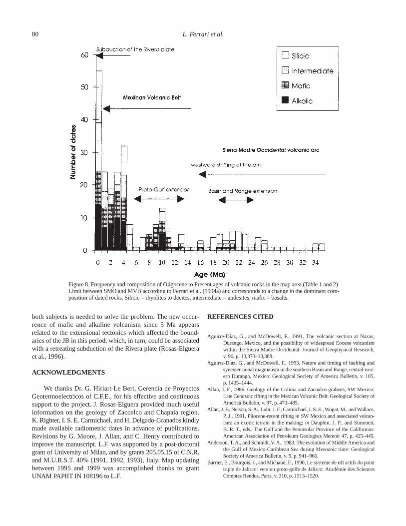
The Oligocene to Quaternary volcanic evolution within thestudy area appears to be marked by episodes of vigorous vol-canism separated by periods of low volcanic activity. This is dis-played in Fig. 8, which shows the distribution of radiometric agessubdivided according to the petrography of the dated samples. InFig. 8, the Plio-Quaternary volcanism is certainly overrepre-sented but we believe that the figure is representative of the mainvariations of the volcanism. It can be seen that a change in thedominant composition of volcanic rocks took place after a periodof reduced volcanic activity in Middle Miocene. In fact, in theOligocene and the Early Miocene the composition of the datedrocks is largely silicic whereas since middle Miocene time, mafic
78 L. Ferrari et al.

Figure 7. Tectonic sketch map showing the Late Miocene to Quaternary structures and volcanic centers. The inferred boundary between JB and SMOis depicted with a bold dashed line.
and intermediate products become dominant. This change hasbeen observed in the volcanism of the whole of central Mexicoand has been interpreted as the limit between the SMO and theMVB (Ferrari et al., 1994a; 1999).
The silicic SMO volcanism shows a peak at the beginningof Early Miocene and then gradually stops in the middleMiocene (Fig. 8). The time of termination of the SMO volcan-ism fits well with the waning of the subduction off Baja Cali-fornia, which, at this latitude, took place between 14 and 12 Ma(Lonsdale, 1991). During the Middle Miocene, volcanic activityis sporadic in the west and totally absent in the central and east-ern part of the study area. During this period, the boundarybetween SMO and JB underwent contractile and transpressivedeformations (Ferrari, 1995).
The volcanism related to the MVB can be divided into threeepisodes: a period of dominantly mafic, sometimes alkaline, vol-
canism between 11 and 8 Ma, an interval of reduced and chemi-cally evolved volcanism between 8 and 5 Ma, and a new episodeof mafic and alkaline volcanism since 5 Ma to the Present. Thefirst period corresponded to the main phase of opening of theGulf of California. This event may have produced a tear in thesubducting slab, allowing the upwelling of asthenospheric mate-rial and the emplacement of alkaline basalts along the preexist-ing discontinuity of the JB-SMO boundary. The 8 to 5 Madecrease of the volcanic activity corresponds to the plate reorga-nization which preceded the birth of the Rivera plate and theexistence of the Mathematician microplate (Mammerickx andKlitgord, 1982; Lonsdale 1991; Lonsdale, 1995). A reduced vol-canic rate for this period may indicate a decrease in the subduc-tion velocity and thus in the magma production rate at depth. Inthis case, however, we do not see a clear relation between vol-canism and plate tectonics and we think that more details on
Geology of the western Mexican Volcanic Belt and adjacent Sierra Madre Occidental and Jalisco Block79
both subjects is needed to solve the problem. The new occur-rence of mafic and alkaline volcanism since 5 Ma appearsrelated to the extensional tectonics which affected the bound-aries of the JB in this period, which, in turn, could be associatedwith a retreating subduction of the Rivera plate (Rosas-Elgueraet al., 1996).
ACKNOWLEDGMENTS
We thanks Dr. G. Hiriart-Le Bert, Gerencia de ProyectosGeotermoelectricos of C.F.E., for his effective and continuoussupport to the project. J. Rosas-Elguera provided much usefulinformation on the geology of Zacoalco and Chapala region.K. Righter, I. S. E. Carmichael, and H. Delgado-Granados kindlymade available radiometric dates in advance of publications.Revisions by G. Moore, J. Allan, and C. Henry contributed toimprove the manuscript. L.F. was supported by a post-doctoralgrant of University of Milan, and by grants 205.05.15 of C.N.R.and M.U.R.S.T. 40% (1991, 1992, 1993), Italy. Map updatingbetween 1995 and 1999 was accomplished thanks to grantUNAM PAPIIT IN 108196 to L.F.
REFERENCES CITED
Aguirre-Díaz, G., and McDowell, F., 1991, The volcanic section at Nazas,Durango, Mexico, and the possibility of widespread Eocene volcanismwithin the Sierra Madre Occidental: Journal of Geophysical Research,v. 96, p. 13,373–13,388.
Aguirre-Díaz, G., and McDowell, F., 1993, Nature and timing of faulting andsynextensional magmatism in the southern Basin and Range, central-east-ern Durango, Mexico: Geological Society of America Bulletin, v. 105,p. 1435–1444.
Allan, J. F., 1986, Geology of the Colima and Zacoalco grabens, SW Mexico:Late Cenozoic rifting in the Mexican Volcanic Belt: Geological Society ofAmerica Bulletin, v. 97, p. 473–485.
Allan, J. F., Nelson, S.A., Luhr, J. F., Carmichael, I. S. E., Wopat, M., and Wallace,P. J., 1991, Pliocene-recent rifting in SW Mexico and associated volcan-ism: an exotic terrain in the making:in Dauphin, J. P., and Simoneit,B. R. T., eds., The Gulf and the Peninsular Province of the Californias:American Association of Petroleum Geologists Memoir 47, p. 425–445.
Anderson, T. A., and Schmidt, V. A., 1983, The evolution of Middle America andthe Gulf of Mexico-Caribbean Sea during Mesozoic time: GeologicalSociety of America Bulletin, v. 9, p. 941–966.
Barrier, E., Bourgois, J., and Michaud, F., 1990, Le systeme de rift actifs du pointtriple de Jalisco: vers un proto-golfe de Jalisco: Académie des SciencesComptes Rendus, Paris, v. 310, p. 1513–1520.
80 L. Ferrari et al.
Figure 8. Frequency and composition of Oligocene to Present ages of volcanic rocks in the map area (Table 1 and 2).Limit between SMO and MVB according to Ferrari et al. (1994a) and corresponds to a change in the dominant com-position of dated rocks. Silicic = rhyolites to dacites, intermediate = andesites, mafic = basalts.

Bönhel, H., Moran-Zenteno, D., Schaaf, P., and Urrutia Fucugauchi, J., 1992,Paleomagnetisc and isotope data from southern Mexico and the contro-versy over the pre-Neogene position of Baja California: Geofísica Inter-nacional, v. 31, p. 253–261.
Bourgois, J., and Michaud F., 1991, Active fragmentation of the North Americaplate at the Mexican triple junction area off Manzanillo: Geo-MarineLetters, v. 11, p. 59–65.
Cameron, M., Nimz, G. J., Kuentz, D., Niemeyer, S., and Gunn, S., 1989, South-ern Cordillera Basaltic Andesite Suite, southern Chihuahua, Mexico: alink between Tertiary continental arc and flood basalt magmatism inNorth America: Journal of Geophysical Research, v. 94, p. 7817–7840.
Campa, M. F., and P., Coney, 1983, Tectonostratigraphic terranes and mineralresources distribution in Mexico: Canadian Journal of Earth Sciences,v. 20, p. 1040–1051.
Castillo, D., and De la Cruz, V., 1992, Reconocimiento estructural y volcanológicoen la zona termal del Domo San Pedro Lagunillas, Nayarit, México:Geofísica Internacional, v. 31, p. 407–415.
Clark, K. F., Damon, P. E., Shafiquillah, M., Ponce, B. F., and Cardenas, D., 1981,Sección geologica-estructural a traves de la parte Sur de la Sierra MadreOccidental, entre Fresnillo y la costa de Nayarit: Asociación de IngenierosMineros, Metalurgistas y Geólogos de México, Memoria Técnica XIV,p. 69–99.
Damon, P. E., Nieto, O. J., and Delgado, A. L., 1979, Un plegamiento neogenicoen Nayarit y Jalisco y evolución geomorfica del Rio Grande de Santiago:Asociacion de Ingenieros Mineros, Metalurgistas y Geólogos de México,Memoria Técnica XIII, p. 156–191.
Delgado-Granados, H., 1992, Geology of the Chapala rift [Ph.D. thesis], Facultyof Science, Tohoku University, Japan, 283 p.
Demant, A., 1979, Vulcanologia y petrografia del sector occidental del Eje Neo-volcanico: Revista, Instituto de Geologia, Universidad Nacional Autónomade México, v. 3, p. 39–57.
Fensby, S., and Gastil, G., 1991, Geologic-Tectonic map of the Gulf of Californiaand surrounding areas,in Dauphin, J. P., and Simoneit, B. R. T., eds., TheGulf and the Peninsular Province of the Californias: American Associa-tion of Petroleum Geologists Memoir 47, p. 79–83.
Ferrari, L., 1995, Miocene shearing along the northern boundary of the Jaliscoblock and the opening of the southern Gulf of California: Geology, v. 23,p. 751–754.
Ferrari, L., and Rosas-Elguera, J., 1999, Late Miocene to Quaternary extension atthe northern boundary of the Jalisco block, western Mexico: The Tepic-Zacoalco rift revised: this volume.
Ferrari, L., Garduño, V. H., Pasquarè, G., and Tibaldi, A., 1994a, Volcanic andtectonic evolution of Central Mexico: Oligocene to Present: GeofísicaInternacional, v. 33, p. 91–105.
Ferrari, L., Garduño, V. H., Innocenti, F., Manetti, P., Pasquarè, G., and Vaggelli,G., 1994b, A widespread mafic volcanic unit at the base of the MexicanVolcanic Belt between Guadalajara and Queretaro: Geofísica Inter-nacional, v. 33, p. 107–124.
Ferrari, L., Pasquarè, G., Venegas, S., Castillo, D., and Romero, F., 1994c,Regional tectonics of western Mexico and its implications for the northernboundary of the Jalisco Block: Geofìsica Internacional, v. 33, p. 139–151.
Ferrari, L., Nelson, S. A., Rosas-Elguera, J., Aguirre-Díaz, G., and Venegas-Salgado, S., 1997, Tectonics and volcanism of the western MexicanVolcanic Belt: in Aguirre-Díaz, G., Aranda-Gomez, J., Carrasco-Nuñez, G., and Ferrari, L., eds., Magmatism and tectonics in central andnorthwestern Mexico—A selection of the 1997 IAVCEI General Assem-bly excursions, Instituto de Geología, Universidad Nacional Autónoma deMéxico, p. 85–29.
Ferrari, L., Lopez-Martinez, M., Aguirre-Díaz, G., and Carrasco-Nuñez, G., 1999,Space-time patterns of Cenozoic arc volcanism in central Mexico: fromthe Sierra Madre Occidental to the Mexican Volcanic Belt: Geology, v. 27,p. 303–307.
Ferrari, L., Conticelli, S., Vaggelli, C., Petrone, C., and Manetti, P., 1999, LateMiocene mafic volcanism and intra-arc tectonics during the early devel-opment of the Trans-Mexican Volcanic Belt: Tectonophysics, in press.
Garduño, V. H., Spinnler, J., and Ceragioli, E., 1993, Geological and structuralstudy of the Chapala Rift, state of Jalisco, Mexico: Geofísica Inter-nacional, v. 32, p. 487–499.
Gastil, G., and Jensky, W., 1973, Evidence for strike-slip displacement beneaththe Trans-Mexican Volcanic Belt: Stanford University Publications inGeological Sciences, v. 13, p. 171–180.
Gastil, G., Krummenacher, D., and Jensky, A. W., 1978, Reconnaissance geologicmap of the west-central part of the state of Nayarit, Mexico: GeologicalSociety of America Maps and Chart Series MC-24, scale 1:200,000.
Gastil, G., Krummenacher, D., and Jensky, A. W., 1979a, Reconnaissance geol-ogy of west-central Nayarit, Mexico: Summary: Geological Society ofAmerica Bulletin, part I, v. 90, p. 15–18.
Gastil, G., Krummenacher, D., and Minch, J., 1979b, The record of Cenozoic vol-canism around the Gulf of California: Geological Society of America Bul-letin, v. 90, p. 839–857.
Gilbert, C. M., Mahood, G., and Carmichael, I. S. E., 1985, Volcanic stratigra-phy of the Guadalajara area, Mexico: Geofísica Internacional, v. 24-1,p. 169–191.
Hasenaka, T., and Carmichael, I. S. E., 1985, A compilation of location, size andgeomorphological parameters of volcanoes of the Michoacan-Guanajuatovolcanic field, central Mexico: Geofísica Internacional, v. 24, p. 577–607.
Hausback, B., 1984, Cenozoic volcanic and tectonics evolution of Baja CaliforniaSur, Mexico:in Frizzell, V., ed., Geology of Baja California peninsula,Pacific Section, SEPM, v. 199, p. 219–236.
Henry, C., 1989, Late Cenozoic Basin and Range structure in western Mexicoadjacent to the Gulf of California: Geological Society of America Bul-letin, v. 101, p. 1147–1156.
Henry, C., and Aranda-Gomez, J. J., 1992, The real southern Basin and Range:Mid- to Late Cenozoic extension in Mexico: Geology, v. 20, p. 701–704.
Johnson, C. M., 1991, Large-scale crust formation and lithosphere modificationbeneath middle to late Cenozoic calderas and volcanic fields, WesternNorth-America: Journal of Geophysical Research, v. 96, p. 13485–13507.
Köhler, H., Schaaf, P., Muller, S. D., Emermann, R., Negendank, J. F. W., andTobschall, H. J., 1988, Geochronological and geochemical investigationson plutonic rocks from the Complex of Puerto Vallarta, Sierra Madre delSur: Geofísica Internacional v. 27, p. 579–592.
Lange, R., and Carmichael, I. S. E., 1990, Hydrous basaltic-andesites associatedwith minette and related lavas in Western Mexico: Journal of Petrology,v. 31, p. 1225–1259.
Lange, R., and Carmichael, I. S. E., 1991, A potassic volcanic front in westernMexico: lamprophyric and related lavas of San Sebastian: GeologicalSociety of America Bulletin, v. 103, p. 928–940.
Lonsdale, P., 1991, Structural pattern of the pacific floor offshore peninsular Cali-fornia: in Dauphin, J. P., and Simoneit, B. R. T., eds., The Gulf and thePeninsular Province of the Californias: American Association of Petro-leum Geologists Memoir 47, p. 87–125.
Lonsdale, P., 1995, Segmentation and disruption of the East Pacific Rise in themouth of the Gulf of California: Marine Geophysical Researches, v. 17,p. 323–359.
Luhr, J. F., and Carmichael, I. S. E., 1980, The Colima volcanic complex, Mexico,Part I: Post-caldera andesites from volcán Colima: Contribution to Miner-alogy and Petrology, v. 71, p. 343–372.
Luhr, J. F., and Carmichael, I. S. E., 1981, The Colima volcanic complex, Mexico:Part II: Late Quaternary cinder cones: Contribution to Mineralogy andPetrology, v. 76, p. 127–147.
Luhr, J. F., and Carmichael, I. S. E., 1982, The Colima volcanic complex, Mexico:Part III: Ash and scoria fall deposits from the upper slopes of volcánColima: Contribution to Mineralogy and Petrology, v. 80, p. 262–275.
Luhr, J., and Lazaar, P., 1985, The southern Guadalajara volcanic chain, Jalisco,Mexico: Geofísica Internacional, v. 24, p. 691–700.
Luhr, J. F., Nelson, S. A., Allan, J. F., and Carmichael, I. S. E., 1985, Active rift-ing in Southwestern Mexico: manifestations of an incipient eastwardspreading-ridge jump: Geology, v. 13, p. 54–57.
Lyons, J. I., 1988, Geology and ore deposits of the Bolaños silver district, Jalisco,Mexico: Economic Geology, v. 83, p. 1560–1582.
Geology of the western Mexican Volcanic Belt and adjacent Sierra Madre Occidental and Jalisco Block81

Mahood, G., 1980, Geological evolution of a Pleistocene rhyolitic center: SierraLa Primavera, Mexico: Journal of Volcanology and Geothermal Research,v. 8, p. 199–230.
Mahood, G., 1981, A summary of the geology and petrology of the Sierra LaPrimavera, Jalisco, Mexico: Journal of Geophysical Research, v. 86,p. 10137–10152.
Mammerickx, J., and Klitgord, K., 1982, Northern East Pacific Rise: from 25 m.y.B.P. to the Present: Journal of Geophysical Research, v. 87, p. 6751–6759.
McDowell, F. W., and Clabaugh, S. E., 1979, Ignimbrites of the Sierra MadreOccidental and their relation to the tectonic history of western Mexico:Geological Society of America Special Paper 180, p. 113–124.
McDowell, F. W., and Keitzer, R. P., 1977, Timing of mid-Tertiary volcanism in theSierra Madre Occidental between Durango City and Mazatlàn, Mexico:Geological Society of America Bulletin, v. 88, p. 1479–1487.
McDowell, F. W., and Mauger, R. L., 1994, K-Ar and U-Pb zircon chronology ofLate Cretaceous and Tertiary magmatism in central Chihuahua State,Mexico: Geological Society of America Bulletin, v. 106, p. 118–132.
Mercier de Lepinay, B., Michaud, F., Calmus, T., Bourgois, J., Poupeau, G., 1997,Large Neogene subsidence event along the Middle America Trench offMexico (18°–19°N): evidence from submersible observations: Geology,v. 25, p. 387–390.
Michaud, F., Quintero, O., Barrier, E., and Bourgois, J., 1991, La frontiére Norddu Bloc Jalisco (Ouest Mexique): localisation et évolution de 13 Ma àl’actuel: Académie des Sciences Comptes Rendus, Paris, v. 312, II,p. 1359–1365.
Michaud, F., Quintero, O., Calmus, T., Bourgois, J., and Barrier, E., 1993: Ladépression de Amatlàn de Cañas (Ouest du Mexique): distension nèogènedans la zone nord du Bloc Jalisco: Académie des Sciences ComptesRendus, Paris, v. 317, II, p. 251–258.
Montigny, R., Demant, A., Delpretti, P., Piguet, P., and Cochemé, J., 1987,Chronologie K-Ar des sèquences volcaniques tertiaires du Nord de laSierra Madre Occidentale (Mexique): Académie des Sciences ComptesRendus, Paris, v. 304, p. 987–992.
Moore, G., Marone, C., Carmichael, I. S. E., and Renne, P., 1994, Basaltic vol-canism and extension near the intersection of the Sierra Madre volcanicprovince and the Mexican Volcanic Belt: Geological Society of AmericaBulletin, v. 106, p. 383–394.
Nelson, S. A., 1980, Geology and petrology of volcàn Ceboruco, Nayarit, Mex-ico: Geological Society of America Bulletin, Part II, v. 91, p. 2290–2431.
Nelson, S. A., and Carmichael, I. S. E., 1984, Pleistocene to Recent alkalic vol-canism in the region of Sanganguey volcano, Nayarit, Mexico: Contribu-tion to Mineralogy and Petrology, v. 85, p. 321–355.
Nelson, S. A., and Hegre, J., 1990, Volcán Las Navajas, a Pliocene-Pleistocenetrachyte-peralkaline rhyolite volcano in the Northwestern Mexican Vol-canic Belt: Bulletin of Volcanology, v. 52, p. 186–204.
Nelson, S. A., and Livieres, R., 1986, Contemporaneous calc-alkaline and alkalinevolcanism at Sanganguey Volcano, Nayarit, Mexico: Geological Societyof America Bulletin, v. 97, p. 798–808.
Nelson, S. A., and Sanchez-Rubio, G., 1986, Trans-Mexican Volcanic Belt fieldguide: Geological Association of Canada, Volcanology Division, 108 p.
Nieto-Obregon, J., Delgado-Argote, L., and Damon, P. E., 1981, Relacionespetrológicas y geocronológicas del magmatismo de la Sierra Madre Occi-dental y el Eje Neovolcanico en Nayarit, Jalisco y Zacatecas: Asociaciónde Ingenieros Mineros, Metalurgistas y Geólogos de México, MemoriaTécnica XIV, p. 327–361.
Nieto-Obregon, J., Delgado-Argote, L., and Damon, P. E., 1985, Geochronologic,petrologic and structural data related to large morphologic featuresbetween the Sierra Madre Occidental and the Mexican Volcanic Belt:Geofísica Internacional, v. 24, p. 623–663.
Nieto-Obregon, J., Urrutia Fucugauchi, J., Cabral-Cano, E., and Guzman de laCampa, A., 1992, Listric faulting and continental rifting in westernMexico—A paleomagnetic and structural study: Tectonophysics, v. 208,p. 365–376.
Nieto-Samaniego,A., Ferrari, L.,Alaniz-Alvarez, S., Labarthe-Hernandez, G., andRosas-Elguera, J., 1999: Variation of Cenozoic extension and volcanism
across the southern Sierra Madre Occidental volcanic province, Mexico:Geological Society of America Bulletin, v. 111, p. 347–363.
Nixon, G. T., Demant, A., Amstrong, R. L., and Harakal, J. E., 1987, K-Ar andgeologic data bearing on the age and evolution of the Trans-Mexican Vol-canic Belt: Geofísica Internacional, v. 26, p. 109–158.
Pasquarè, G., Ferrari, L., Garduño, V. H., Tibaldi, A., and Vezzoli, L., 1991, Geol-ogy of the central sector of Mexican Volcanic Belt, States of Guanajuatoand Michoacan: Geological Society of America Map and Chart series,MCH 072, 22 p.
Quintero, O., Michaud, F., Bourgois, J., and Barrier, E., 1992, Evolución de lafrontera septentrional del bloque Jalisco, México, desde hace 17 Ma. Uni-versidad Nacional Autónoma de México, Instituto de Geología, Revista,v. 10, p. 111–117.
Righter, K., and Carmichael, I. S. E., 1992, Hawaiites and related lavas in theAtenguillo graben, western Mexican Volcanic Belt: Geological Society ofAmerica Bulletin, v. 104, p. 1592–1607.
Righter, K., Carmichael, I. S. E., and Becker, T., 1995, Pliocene-Quaternary fault-ing and volcanism at the intersection of the Gulf of California and theMexican Volcanic Belt: Geological Society of America Bulletin, v. 107,p. 612–627.
Rodriguez-Castaneda, J. L., and Rodriguez-Torres, R., 1992, Geología estructuraly estratigrafía del area entre Guadalajara y Tepic, estados de Jalisco yNayarit, México: Revista Instituto de Geologia, Universidad NacionalAutónoma de México, v. 10, v. 99–110.
Rosas-Elguera, J. E., Nieto-Obregon, J., and Urrutia-Fucugauchi, J., 1993, Ambi-ente estructural en la frontera Norte del bloque Jalisco,in Delgado-ArgoteL., and Martin-Barajas A., eds., Contribuciones a la Tectónica del Occi-dente de México, Union Geofísica Mexicana, v. 1, p. 175–192.
Rosas-Elguera, J., Ferrari, L., Urrutia-Fucugauchi, J., and Garduño, V. H., 1996,The continental boundaries of the Jalisco block and their influence in theNeogene kinematics of western Mexico: Geology, v. 24, p. 921–924.
Schaaf, P., Köhler, H., Müller-Sohnius, D., and von Drach, D., 1993, The PuertoVallarta batholith—its anatomy displayed by isotopic fine structure: Pro-ceedings of the First Circum-Pacific and Circum-Atlantic Terrane Con-ference, p. 133–135.
Scheubel, F. R., Clark, K., and Porter, E., 1988, Geology, tectonic environment andstructural control in the San Martin de Bolaños district, Jalisco, Mexico:Economic Geology, v. 83, p. 1703–1720.
Sedlock, R. L., Ortega-Gutierrez, F., and Speed, R. C., 1993, Tectonostratigraphicterranes and tectonic evolution of Mexico: Geological Society of AmericaSpecial Paper 278, 148 p.
Tuta, Z. H., Sutter, J. F., Kessler, S. E., and Ruiz, J., 1988, Geochronology of mer-cury, tin, and fluorine mineralization in northern Mexico: Economic Geol-ogy, v. 83, p. 1931–1942.
Venegas, S., Herrera, J. J., and Maciel, F. R., 1985, Algunas características de laFaja Volcánica Mexicana y de sus recursos geotérmicos: Geofísica Inter-nacional, v. 24, p. 47–83.
Verma, S. P., Lopez-Martinez, M., and Terrell, D. J., 1985: Geochemistry ofTertiary igneous rocks from Arandas-Atotonilco area, northeast Jalisco,Mexico: Geofísica Internacional, v. 24, p. 31–45.
Wallace, P., and Carmichael, I. S. E., 1989, Minette lavas and associated leucititesfrom the western front of the MVB: petrology, chemistry and origin: Con-tribution to Mineralogy and Petrology, v. 103, p. 470–492.
Wallace, P., and Carmichael, I. S. E., 1992, Alkaline and calk-alkaline lavas nearLos Volcanes, Jalisco, Mexico: geochemical diversity and its significancein volcanic arcs: Contribution to Mineralogy and Petrology, v. 111,p. 423–439.
Wallace, P., and Carmichael, I. S. E., 1994, Petrology of Volcán Tequila, Jalisco,Mexico: disequilibrium phenocryst assemblages and evolution of the sub-volcanic magma system: Contributions to Mineralogy and Petrology,v. 117, p. 345–361.
Wallace, P., Carmichael, I. S. E., Righter, K., and Becker, T., 1992, Volcanism andtectonism in western Mexico: A contrast of style and substance: Geology,v. 20, p. 625–628.
Wark, D. A., 1991, Oligocene ash flow volcanism, northern Sierra Madre Occi-
82 L. Ferrari et al.

dental: role of mafic and intermediate-composition magmas in rhyolitegenesis: Journal of Geophysical Research, v. 96, p. 13389–13411.
Wark, D. A., Kempter, K. A., and McDowell, F. W., 1990, Evolution of waningsubduction-related magmatism, northern Sierra Madre Occidental, Mex-ico: Geological Society of America Bulletin, v. 102, p. 1555–1564.
Watkins, N. D., Gunn, B. M., Baksi,A. K.,York, D., and Ade-Hall, J., 1971, Paleo-magnetism, geochemistry and potassium-argon ages of the Rio Grande deSantiago volcanics, Central Mexico: Geological Society of America Bul-letin, v. 82, p. 1955–1968.
Webber, K. L., Fernandez, L. A., and Simmons, W. B., 1994, Geochemistry andmineralogy of the Eocene-Oligocene volcanic sequence, southern SierraMadre Occidental, Juchipila, Zacatecas, Mexico: Geofísica Internacional,v. 33, p. 77–89.
Wright, J. V., and Walker, G. P. L., 1981, Eruption, transport and deposition ofignimbrite: A case study from Mexico: Journal of Volcanology and Geo-thermal Research, v. 9, p. 111–131.
Zimmermann, J.-L., Stussi, J. M., Gonzalez-Partida, E., and Arnold, M., 1988,K-Ar evidence for age and compositional zoning in the Puerto Vallarta-Rio Santiago batholith (Jalisco, Mexico): Journal of South AmericanEarth Sciences, v. 1, p. 267–274.
MANUSCRIPTACCEPTED BY THESOCIETY AUGUST31, 1998
Geology of the western Mexican Volcanic Belt and adjacent Sierra Madre Occidental and Jalisco Block83
Printed in U.S.A.