Geology of the Moxie Pluton - USGS · Geology of the Moxie Pluton in the Moosehead Lake,Jo-Mary...
46
Transcript of Geology of the Moxie Pluton - USGS · Geology of the Moxie Pluton in the Moosehead Lake,Jo-Mary...

Geology of the Moxie Pluton
in the Moosehead Lake
,Jo-Mary Mountain Area,
Piscataquis County, Maine lJy G. H. ESPENSHADE
1'1 E 0 L 0 G I c A L s u R v E y B u L L E T I N 1 3 4 0
.. A discussion of the rocks (troctolite, f~orite, gabbro, diorite, and quartz t~iorite) and structure of the northeastern tart of the Moxie pluton
J:~TITED STATES GOVERNMENT PRINTING OFFICE, WASHINGTON : 1972

UNITED STATES DEPARTMENT OF THE INTERIOR
ROGERS C. B. MORTON, Secretary
GEOLOGICAL SURVEY
V. E. McKelvey, Director
Library of Congress catalog-card No. 72-600030
For sale by the Superintendent of Documents, U.S. Government Printin~ Office Washin~ton, D.C. 20402 Stock Number 2401-2113

CONTENTS
Page Abstract ___ ____ ____ _________________ _ ______ __ _ ___ ___ ___ __ _ ___ ___ ___ 1 Introduction _ ____ ________ __________ ________ _______ __ ___ _ __ _ _________ 1
Principal geologic features ----------------------------------------- 4 Sedimentary rocks and interlayered igneous rocks ----·-------------- 5
Cambrian or Ordovician rocks --------------------------------- 5 Silurian rocks ----------------------------------------'"---------- 5 Devonian rocks -------------------------------·----------------- 6
Devonian plutonic rocks -------------------------------------------- 8 The Moxie pluto,n --------------------------·-------------------- 8
General features ------------------------------------------ 8 Modal composition ------------------------·----------------- 9 Chemical composition -------------------------------------- 14 Mineralogy ------------------------------------------------ 17
Plagioclase -------------------------------------------- 17 Olivine ----------------------------------------------- 18 Orthopyroxene ----------------------------------------- 18 Clinopyroxene ----------------------------------------- 18 Hornblende ------------------------------------------- 18 Cummingtonite ---------------------------------------- 19 Quartz ------------------------------------------------ 19 Biotite ________________ -------------·------------ ___ ____ 19
Opaque minerals -------------------------------------- 19 Apatite _________ ____ ____ ____________ _ ____________ _____ 20
Other minerals ---------------------------------------- 20 Variations in composition of plagioclase, olivine, and ortho-
pyroxene ------------------------------------------------ 20 Rock types and their distribution ------------------------- 21 Structure ------------------------------------------------- 24 Differentiation --------------------------------------------- 28
The Katahdin pluton ------------------------------------------- 29 Age relations of the Moxie and Katahdin plutons ---------------- 31
Contact metamorphism ---------------------------------------------- 31 Physiography -------------------------------------··---------------- 32 Geophysical investigations ------------------------------------------ 33 Economic geology -------------------------------------------------- 34 References cited --------------------------------------------------- 37
ILLUSTRATIONS
[Plates are in pocket]
PLATE 1. Geologic map of the Moosehead Lake-Jo-Mary Mountain area, Piscataquis County, Maine.
2. Map and sections showing aeromagnetic and structural features of the northeastern part of the Moxie pluton, Piscataquis and Somerset Counties, Maine.
III
IV CONTENTS
PLATE 3. Bouguer gravity map of the northeastern part of the Moxie pluton, Piscataquis and Somerset Counties, Maine. Page
FIGURE 1. Index map of central Maine ---------------------------- 2 2. Diagram showing modal olivine, pyroxene, amphibole, and
quartz in samples from the Moxie pluton ______________ 13 3. Diagram showing MgO, Fe0+2Fe203+Mn0, and K20+
N a20 in samples from the northeastern part of the Moxie
pluton ------------------------------------------------ 30
TABLES
TABLE 1. Modes, mineral compositions, and bulk densities of samples from the Moxie pluton, Moosehead Lake-J o-Mary Moun-
tain area ----------------------------------------------- 10 2. Chemical analyses, semiquantitative spectrographic analyses,
CIPW norms, modes, and mineral composition of samples from the Moxie pluton, Moosehead Lake-J o-Mary Moun-tain area ---------------------------------------------- 15
3. Compositions of coexisting plagioclase, olivine, and orthopyroxene in samples from the Moxie pluton, Moosehead Lake-Jo-Mary Mountain area --------------------------------- 21

GEOLOGY OF THE MOXIE PLUTON IN THE MOOSEHEAD LAKE-JO-MARY MOUNTAIN AREA, PISCATAQUIS COUNTY,
MAINE
By G. H. ESPENSHADE
ABSTRACT
The Moxie pluton in west-central Maine is a large mafic intrusion nearly 50 miles long and about 145 square miles in area. The northeastern part of the pluton (about 90 square miles), underlying Moosehead Lake and extending eastward to near Jo-Mary Mountain, is described in this report. Exposures are very scarce in this part of the pluton because of the widespread cover of lakes, swamps, glacial drift, and talus. The pluton intrudes Early Devonian ( ?) slate, siltstone, and sandstone and appears on the basis of potassium-argon dating of biotite to be Early Devonian in age. The southern part of the Katahdin granitic pluton of Devonian age adjoins the eastern end of the Moxie pluton. The sedimentary rocks are tightly folded, and adjacent to both plutons they are thermally metamorphosed to hornfels containing one or more of the minerals sillimanite, cordierite, andalusite, and biotite. The plutons are late orogenic or postorogenic.
Troctolite and norite are the most abundant rock types in the Moosehead Lake area; gabbro is less common. Diorite and quartz diorite form the eastern part of the pluton. Six chemical and spectrographic analyses and 3.2 modal analyses of mafic rocks are given. In troctolite, norite, and gabbro
- the composition of plagioclase is An4s-s5, of olivine Fo~c- a, and of orthopyroxene EnJHic· In diorite and quartz diorite the composition of plagioclase is An3<-7o, and of orthopyroxene En4t•-m· Biotite and amphibole, both hornblende and cummingtonite, are present in nearly all rocks but are most abundant in diorite and quartz diorite. Rocks that contain more amphibole than combined pyroxene and olivine are classed as diorite. Laminar structure caused by parallel orientation of plagioclase crystals in the mafic rocks is very common; compositional layering is rare. Geologic and geophysical data suggest that the Moxie pluton is a sheet several miles thick which dips steeply southeast where the outline of the pluton is narrow, and which undulates and dips more gently where the outline is wide and irregular. Disseminated pyrrhotite occurs in the Moxie pluton at various places southwest of the area described in this report but has not been found in the northeastern part of the pluton.
INTRODUCTION
The area described in this report is in central Maine, extending eastward from the southern part of Moosehead Lake for about 25 miles (fig. 1). The country east of Moosehead Lake is rugged and has numerous irregular knobs and ridges that rise 1,000 to
1
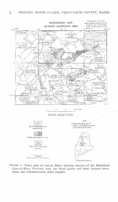
2 GEOLOGY, MOXIE PLUTON, PISCATAQUIS COUNTY, MAINE
MOOSEHEAD LAKEJO-MARY MOUNTAIN AREA
KATAHDIN PLUTON
Voges of 356 and 361 m.y. for samples from Harrington lake quadrangle to the
EJ Quartz monzonite and
granodiorite
Diorite and quartz diorite
Troctolite, norite, and gabbro
Contact
10 MILES
EXPLANATION
e4oo
Potassium-argon age of biotite in millions of years, (Faul and others, 1963)
Dashed where approximately located
J)IOEX MAP OF MAISE
FIGURE 1.-Index map of central Maine showing location of the Moosehead Lake-Jo-Mary Mountain area, the Moxie pluton and other igneous intrusions, and radiometrically dated samples.

INTRODUCTION 3
2,000 feet above the valleys. Most streams in the western part of the region drain into Moosehead Lake and thence west into the Kennebec River; streams in the eastern part drain southeast to the Penobscot River.
The area is all wooded, and most of the lowland is accessible by permanent roads, temporary or abandoned logging roads, and trails. Mountainous parts are generally reached only by trails, many of them seldom used; the Appalachian Trail crosses the eastern half of the area. The nearest settlement is the town of Greenville, a few miles south of the mapped area on the south end of Moosehead Lake. Lumbering and outdoor recreation are the major activities in this part of Maine.
Geologic mapping in the area was undertaken to investigate the northeastern part of the Moxie pluton, a large mafic intrusion that trends northeast for about 50 miles (fig. 1). Part of the Moxie pluton had previously been studied in detail by the writer and associates in the adjacent Greenville quadrangle (Espenshade and Boudette, 1964, 1967). The Moosehead Lake~Jo-Mary Mountain area was mapped in reconnaissance. It is doubtful, however, that detailed geologic mapping would add much important data because bedrock exposures are scarcer here than they are in the Greenville quadrangle.
Most of the geologic mapping of this area was done by the writer, Ian M. Lange, and David A. N eillis during the summers of 1963 and 1964. A small part of the region was mapped earlier by the writer and Baudette during the survey of the Greenville quadrangle.
Other colleagues in the Geological Survey have contributed to this investigation through discussions, analytical services, and help with laboratory studies. D. L. Southwick guided the writer in the use of the universal stage to determine composition of plagioclase and orthopyroxene. M. F. Kane, Isidore Zietz, and others advised on the structural interpretations of aeromagnetic and gravity surveys of the Moxie pluton.
Geologic investigations in this part of Maine in recent years have been by Hurley and Thompson (1950), Visher (1960), Boncot (1954, 1961), Boucot, Griscom, and Allingham (1964), Griscom (1966), Rankin (1968), and Boucot and Heath (1969). Glacial geology in the area has been studied by Leavitt and Perkins (1935) and Caldwell (1960, 1966). Aeromagnetic surveys have been made by Balsley and Kaiser (1954), Balsley, Blanchett, Kirby, and others (1957), Bromery, Vargo, and others (1963), and Henderson, Smith, and others (1963). Gravity studies have

4 GEOLOGY, MOXIE PLUTON, PISCATAQUIS COUNTY, MAINE
been made by Kane and Peterson (1961) and Kane and Bromery ( 1966, 1968). Geological, geophysical, and geochemical surveys were carried out by Stickney, Young, and Wing (1965). Geochemical prospecting has been described by Post and Hite (1964).
PRINCIPAL GEOLOGIC FEATURES
Geological mapping was concentrated on the intrusive rocks of the area, mainly the mafic rocks of the Moxie pluton, and less attention was paid to geologic problems of the intruded country rocks. The Moxie pluton is a long irregularly shaped body that extends for almost 50 miles from Moxie Mountain northeast to near Jo-Mary Mountain (fig. 1). Troctolitic and noritic rocks are the major rock varieties in the southwestern two-thirds of the pluton; gabbroic rocks are less abundant. Diorite and quartz diorite predominate in the northeastern third of the pluton.
The part of the Moxie pluton within the maped area underlies about 90 square miles, nearly two-thirds of the pluton's total area (about 145 square miles). Bedrock exposures are much scarcer in the northeastern part of the pluton than in the southwestern part. Large areas of the pluton are covered by Moosehead Lake and by ponds, swamps, and thick glacial drift in the low country and valley extending east from Moosehead Lake. Because of the very poor exposures, relations between the different varieties of mafic rock and between the eastern end of the Moxie pluton and the Katahdin granitic pluton, which underlies about 400 square miles northeast of the mapped area (pl. 1; Hussey and others, 1967), could be determined. only in a general way.
The two plutons intrude slate, siltstone, and sandstone beds that are probably mainly of Early Devonian age. Older strata of Silurian and pre-Silurian age are north of the Moxie pluton (pl. 1; Boucot, 1961). Aureoles of contact metamorphism surround both plutons, but the aureole surrounding the Moxie pluton has higher temperature minerals and is wider than .. that around the Katahdin pluton. Hornfels containing one or more of the minerals sillimanite, andalusite, and cordierite forms a zone that in a few places is as much as half a mile wide adjacent to the Moxie pluton. Andalusite alone persists in the next outer zone to a distance of about a mile from the pluton, and biotite occurs as much as 2 miles from the pluton. Chlorite is present and biotite is absent outside the contact aureole. Granitic dikes are locally abundant in the contact aureole of the southern part of the Katahdin pluton; no mafic dikes are adjacent to the Moxie pluton.
Both plutons were emplaced in the late stage of, or after, the main period of folding in the area, because the plutonic rocks

SEDIMENTARY AND INTERLAYERED IGNEOUS ROCKS 5
are not deformed or metamorphosed. Potassium-argon dates on biotite in samples from the two plutons indicate that both plutons are of Devonian age and that the Moxie mafic pluton is older than the Katahdin granitic pluton (fig. 1; Faul and others, 1963).
SEDIMENTARY ROCKS AND INTERLA YERED IGNEOUS ROCKS
CAMBRIAN OR ORDOVICIAN ROCKS
Mafic volcanic rocks are exposed for a distance of more than 11;2 miles along and north of a lumbering road leading toward Black Pond, in the northeast corner of the First Roach Pond quadrangle (pl. 1). Much of the rock is dark-green breccia tuff or lapilli tuff containing angular fragments as large as several inches across. Some rock is rather massive and has fine- to medium-grained diabasic texture; it is composed of small altered euhedral plagioclase crystals, augite, hornblende, quartz, and abundant opaque minerals. The plagioclase is extensively altered to sericite, chlorite, zoisite, and carbonate.
These rocks are presumed to be pre-Silurian in age because they are overlain by limy sedimentary rocks containing Silurian fossils and because they are in the southern part of a large anticlinal area of pre-Silurian (Cambrian or Ordovician) sedimentary and volcanic rocks that extends· about 15 miles to the north (Boucot and others, 1964; Hussey and others, 1967; Boucot and
._ Heath, 1969, pl. 13). Mafic volcanic rocks in the Ripogenus Lake ---area,on the northeast side of this anticline are possibly Ordovician
in age (Grjscom, 1966).
SILURIAN ROCKS
Limy rocks-conglome-rate, sandstone, and siltstone-are exposed intermittently for at lea~sf 2 miles just south of the mafic volcanic rocks (pl. 1) . The con tat t between the sedimentary and volcanic rocks can be readily traced by abundant outcrops for nearly one-half mile east from the srra~l knob outlined by the 1,560-foot coutour 7,700 feet northwest of the peak of Farrar Mountain. Limy conglomerate is the most abundant rock variety in this locality and is exposed in areas more than 100 feet wide. The conglomerate is composed of angular pebbles of greenstone and limestone, many of which are less than 2 inches across, in a limy, silty matrix; greenstone boulders as much as 3 feet in diameter are present locally. Thin beds of red sandstone and red and green shale are interbedded with the conglomerate.
Green to gray limy siltstone is exposed at several places east and west of the limy conglomerate and is presumed to be part of

6 GEOLOGY, MOXIE PLUTON, PISCATAQUIS COUNTY, MAINE
the sam,e sequence of rocks. Fossils were found by the writer in a 2-foot bed of dark-brownish-gray limy siltstone near the 1,400-foot contour of a small ridge about three-tenths mile west of Bear Pond (pl. 1). A. J. Boucot (written commun., Nov. 4, 1964; Boucot and Heath, 1969, p. 53) reported the following brachiopods from this collection (sample M792, USNM locality 12119) : Leang ella sp., Leptaena "rhomboidalis," Cyrtia? sp., Atrypa "reticularis," lsorthis sp., Atrypina sp., Dicaelosia sp., and Meristina sp. Boucot (Boucot and Heath, 1969, p. 33) stated that these fossils may span the time from Upper Llandovery (C3) to Wenlock, but he indicated a C3-C5 preference.
About 2 miles west of this locality, dark-red siltstone is exposed along the road near the base of the east slope of Siras Hill. These beds are here grouped with the impure calcareous beds described previously (pl. 1), which have red shale in places. However, the red beds on Siras Hill may belong in the Capens Formation, as Boucot and Heath ( 1969, p. 52-53) pointed out.
Limy beds, consisting mostly of limestone conglomerate, silty dolomite, and some thin beds of limy sandstone, are exposed over a width of about 300 feet in the railroad bend on the west side of Moosehead Lake, just southeast of Deep Cove (pl. 1). The conglomerate contains pebbles of dense gray limestone or dolomite and coarse crinoidal limestone. Similar rocks are exposed along the railroad tracks one-half mile farther south. An outcrop of silty dolomite was found 11j2 miles west of Mooseh~JL~ Lake and two-tenths mile north of Burnham Pond. Boucot~{1961, p. 177-178) said that no diagnostic fossils have been-~found in these rocks and that their age could be betweerr-·Early Silurian and Oriskany. He has since placed these--strata in the Silurian (Boucot and Heath, 1969, p. 52, __ pl.13).
On the northeast shore of f!eer Island are beds of red and green slate and thin beds of green sandstone, which Boucot (1961, p. 177) has named the Capens Formation (pl. 1). Red slate is also exposed on State ~hway 15, about 1.3 miles southeast of the Kennebec River. Boucot (1961, p. 177) originally assigned Silurian to Early Devonian age to the Capens Formation; later he called these beds Devonian (Boucot and others, 1964) ; and he has since assigned them to the Silurian (Boucot and Heath, 1969, p. 53-54, pl. 13).
DEVONIAN ROCKS
Overlying the Capens Formation on Deer Island are quartzitic beds that Boucot ( 1961, p. 176-177; Boucot and Heath, 1969, p. 43, pl. 13) has called the Whisky Quartzite. These beds are com-
SEDIMENTARY AND INTERLAYERED IGNEOUS ROCKS 7
posed of coarse quartzite and fine conglomerate, which contain abundant grains of feldspar and blue quartz and pebbles of felsite, chert, and slate as large as 2 inches across. These strata are exposed in areas 50 to 150 feet wide along the shore; they seem to be thickened by folding in the widest exposures (pl. 1). Boucot ( 1961, p. 177) once assigned a Silurian to Early Devonian age to the Whisky, but later he called this unit Devonian (Boucot and others, 1964; Boucot and Heath, 1969, p. 43).
Dark-gray slate, siltstone, and fine-grained feldspathic sandstone, generally contact metamorphosed, are present nearly everywhere adjacent to the Moxie pluton and the southern part of the Katahdin pluton (pl. 1). No fossils were found in the sedimentary rocks in the vicinity of the plutons, but lithologically these sedimentary rocks are very similar to those of the Seboomook Formation (Lower Devonian), which is widely distributed to the north (Boucot, 1961, p. 169-170; Hussey and others, 1967; Boucot and Heath, 1969, p. 33-35). Probably many of the beds adjacent to the Moxie pluton are equivalent to the Seboomook or to the Tarratine Formation (Boucot, 1961, p. 165-167; Boucot and Heath, 1969, p. 25-30), but younger beds equivalent to the Tomhegan Formation (also Lower Devonian) may also be present (Boucot, 1961, p. 161-163; Boucot and Heath, 1969, p. 17-21). The rocks bordering the south side of the Moxie pluton are the northeast extension of the unnamed unit of pelitic rocks, mapP P. in the Greenville quadrangle, which is thought to correlate at lea in part with the Seboomook and therefore to be probably of early e~ian age (Espenshade and Baudette, 1964; 1967, p. F10-F13). '-
Felsite occurs ~-Little Boardman Mountain in the central part of Jo-Mary Mountain quadrangJe, at localities about 1 mile southwest and 2 miles northwest of the mountain, and on the southwest slope of Farrar Mountain in the northeast part of the First Roach Pond quadrangle (pl. 1). The largest felsite body, on the ridge of Little Boardman Mountain, is about 500 feet wide and nearly a mile long. This felsite is medium green to gray and con
tains small phenocrysts 1 to 2 mm long of feldspar and hornblende in a very dense matrix of quartz and feldspar; fine sulfide grains are disseminated through the rock. Similar rocks occur at the other localities mentioned. Fine sulfides seem to be most abundant in the crescentic felsite body included in granitic rocks about 2 miles northwest of Little Boardman Mountain (pl. 1). The felsite on Farrar Mountain is in thin layers interbedded with the sedimentary rocks; exposures on old logging trails are

8 GEOLOGY, MOXIE PLUTON, PISCATAQUIS COUNTY, MAINE
too scattered to permit mapping of the felsite here. These various bodies of felsite are either volcanic or shallow intrusions.
These small felsite bodies may be equivalent in age to the Early Devonian extrusive rhyolite and shallow felsic intrusions that occur in a long northeast-trending belt 10 to 15 miles northwest of the Moxie pluton (Rankin, 1968; Boucot and Heath, 1969, p. 21-25). The nearest body in this belt is the large mass of rhyolite that forms Big Spencer Mountain, about 9 miles northwest of the felsite exposures on Farrar Mountain.
DEVONIAN PLUTONIC ROCKS
THE MOXIE PLUTON
General Features
The Moxie pluton is a large mafic intrusion that extends for nearly 50 miles northeast from Moxie Mountain to the southern part of the Katahdin pluton (fig. 1; Hussey and others, 1967). The pluton has an irregular elongated shape and ranges in width from less than 1 to about 9 miles. Its area is about 145 square miles, about 90 square miles of which is in the area discussed here.
Much of the pluton underlies valleys or lowlands that are bordered by ridges of hornfels, a relationship that reflects the low resistance of the mafic rocks to weathering and erosion compared with the hornfels. The pluton is very poorly exposed around the southern part of Moosehead Lake and in the country to the east (pl. 1). A considerable part of the pluton underlies osehead Lake, and east of the lake the pluton is larg_ covered by glacial drift, swamps, and ponds. In spite o:Vfhe poor ex-
../ posures, the contacts of the pluton can be lQr;ated within a few hundred feet in many places by mean~ ·ol·Il~rnfels exposures and abrupt steepening of slopes adjacent to the contact, as well as by sharp aeromagnetic anomalies. The contact of the eastern end of the Moxie pluton again~t the Katahdin pluton is nowhere exposed, howev~r, and the contact shown on plate 1 is inferred from ~ery poor data.
In the Moosehead Lake area, troctolite and norite are the main rock types in the Moxie pluton; some gabbro and diorite are also present. The eastern end of the pluton is composed of diorite and quartz diorite. The different types could only be mapped in the field in a very generalized manner, largely because of the scarcity of exposures but also because of the difficulty of identification by visual inspection alone. For this report, 94 thin sections of samples from this part of the pluton were examined, and modal analyses were made of 32 of these samples. This micro-

DEVONIAN PLUTONIC ROCKS 9
scopic study was an important source of information used in outlining the areas of dioritic rocks on plate 1.
Plagioclase is the dominant mineral in all the rocks, generally making up one-half to two-thirds of the total mineral content. Plagioclase composition ranges from bytownite in some troctolite and norite to andesine in some diorite and quartz diorite. Olivine and orthopyroxene are the principal mafic minerals in troctolite and norite and range from magnesium rich to iron rich. Amphibole, both hornblende and cummingtonite, is the main mafic mineral in diorite, but it is exceeded in amount by biotite in quartz diorite.
A very conspicuous igneous lamination formed by parallel orientation of plagioclase crystals is present in all types of mafic rock at many places (pl. 1). The dip of this igneous lamination is most commonly north to east. Compositional layering is rare; where present it is parallel to the igneous lamination. The mafic rocks of the Moxie pluton are characteristically very fresh and unmetamorphosed, although some alteration does occur locally in dioritic rocks.
Modal Composition
The rocks in this part of the Moxie pluton vary widely in composition. Olivine is the dominant mafic mineral in troctolite; orthopyroxene is much more common than clinopyroxene and is the principal mafic mineral in norite (table 1). These two rock types are most abundant in the Moosehead Lake area (pl. 1) and are alt'o the major types just southwest in the Greenville quadrangle (Espenshade and Boudette, 1967, table 4, pl. 1A). Troctolite and norlte intergrade uniformly in this part of the pluton; the content of orthopyroxene increases as olivine decreases, and plagioclase content ranges from about 50 to 70 percent.
Amphibole (both hornblende and cummingtonite) is present in minor quantities in much of the troctolite and norite but becomes the major mafic mineral in most dioritic rocks, which range from pyroxene diorite through diorite to quartz diorite (table 1). Biotite occurs in all rock types but is most abundant in quartz diorite; it exceeds amphibole in quartz-rich rocks. Dioritic rocks make up the eastern end of the pluton and also part of the pluton's northern side (pl. 1). Very few dioritic rocks were found to the southwest in the Greenville quadrangle (Espenshade and Boudette, 1967, table 4).
The densities of samples from this part of the Moxie pluton range from 2.80 to 3.25 (table 1) ; they are generally higher for troctolite, norite, and gabbro then for diorite. A broad range of
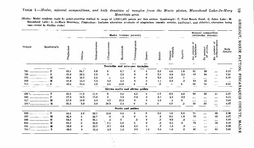
TABLE 1.-Modes, mineral compositions, and bulk densities of samples from the Moxie pluton, Moosehead Lake-Jo-Mm·y 1-l 0
Mountain area [Modes: Modal analyses made by point-counting method in range of 1,300-1,40!) points per thin section. Quadrangle: F, First Roach Pond; S, Sebec Lake; M,
c;':) Moosehead Lake; J, Jo-Mary Mountain. Plagioclase: Includes alteration products of plagioclase (mostly sericite, kaolinite?, and chlorite),alteration being trj rare except in dioritic rocks] 0
~
Mineral composition 0 c;':)
Modes (volume percent) (molecular percent) ,.1-<1
$ Qi
~ Qi Qi ..... ~~ 1'l @ ·;:: OQI 0 Qi Qi Sample Quadrangle Ql >< X Qi .s rJl ~~ +'~ +>0 >< "0 ~I-;
~ e 8 ~ t>ll Oil <lJ <lJ C) l;;: w» Bulk ~
<l » <lJ ~ Qlfjj 1::.9 +'P. trj <lJ » ·s "
...., §:a ~ 0 density 0 .s ~ p. :0 ..... $ &.s ~ ot>ll o..c
j ~ 0 E s "' :g C)C<j
C) ..... C)+'
.~ .s "' ~E p. ~-a "' ~ 0 _;:l :::: 00 ~0 ll; 0 0 5 :r: u CJ ~ 0 <11 < ~ ril ~
q t-3
Troctolite and pyroxene troctolite 0
4.4 1.5 61 26 3.10 z 795 ------------ F 62.1 24.7 3.9 0 0.7 0 0 2.6 -- '" 720 ------------ s 53.6 29.1 3.3 0 2.5 0 0 2.9 6.0 2.5 63 36 -- 3.25 ~ 572 ------------ M 69.5 15.7 5.8 .1 1.4 0 0 2.1 5.3 .1 2.99 ~ -- -- -- 00 569 ------------ M 64.6 14.9 7.3 3.0 2.2 0 0 1.1 6.6 .3 54 45 -- -- 0 718 ------------ s 49.4 24.4 4.5 2.9 18.0 0 0 .8 .1 0 85 74 3.03 >
t-3 Olivine norite and olivine gabbro >
!:) 5881 ____________ F 69.5 11.3 11.9 0 0.4 0.6 0 2.7 3.3 0.4 58 28 31 3.07 q 585 ------------ F 57.2 10.3 13.6 0 2.9 2.9 0 6.7 4.2 2.3 -- 3.11 ~
-- -- 00 317 ------------ M 57.5 10.6 9.6 6.7 13.3 0 0 1.8 .4 0 -- -- 2.89 185 1 ____________ M 55.3 5.9 2.0 26.3 5.4 0 0 0 4.9 .2 48 50 3.07 0 -- 0
N orite and gabbro q z
589 ------------ F 49.4 2.4 20.7 19.0 5.2 0 0 2.0 1.0 0.4 71 -- 62 3.06 t-3 637 ------------ M 62.0 0 28.7 .4 .3 0 0 .3 6.5 1.8 73 -- 52 3.07 ,.1-<1
560 ------------ M 58.5 0 35.1 .4 0 .5 0 .8 3.9 .8 -- -- -- 3.03 ~ 644 ------------ M 53.3 0 30.5 \. 2.1 5.5 0 0 .3 8.2 0 76 -- 56 3.08 > 561 ------------ M 59.6 0 22.7 6.7 6.6 2.1 0 .7 1.3 .3 -- -- 2.96 ~
7941 ____________ F 63.5 0 21.4 4.3 1.0 3.3 1.8 3.0 1.6 .2 61 -- 55 2.95 z trj

Pyroxene diorite
732 ------------ F 65.5 0 9.3 0 5.8 5.3 0.7 6.9 796 ------------ F 56.5 0 11.1 0 20.7 0 4.2 6.3 598 1 ____________ M 64.5 0 4.4 2.7 3.0 19.1 2 .5 .7 753 ____________ F 71.0 0 4.2 0 8.3 5.5 1.1 6.7
Diorite
665 ------------ J 53.0 0 4.5 0 1.3 23.9 2.4 10.8
640 ------------ F 54.2 0 1.5 0 3.5 18.9 3.4 13.7 674 1 ____________ J 56.7 0 1.3 0 7.1 17.2 3 2.3 9.7
680 ------------ J 65.1 0 0 0 1.4 20.4 .6 10.5
763 ------------ J 50.0 0 0 0 0 32.8 3 4.7 12.3
Quartz diorite
789 ------------ F 58.4 0 4.0 0 0 10.8 12.0 13.3
'lOS ------------ F 54.1 0 2.1 0 3.8 16.6 7.1 14.3
609 ------------ F 62.7 0 0 0 0 19.9 5.7 7.5
681 ------------ J 53.3 0 0 0 19.7 0 10.7 15.7 6891 ____________ F 47.4 0 0 0 21.4 0 15.9 14.2
626 ------------ F 47.9 0 0 0 0 9.1 19.7 22.7
731 ------------ F 55.0 0 0 0 0 6.2 3 19.5 17.5
760 ------------ F 52.4 0 0 0 0 5.9 19.7 21.4
!Chemically analyzed sample ; see table 2. 2 Cummingtonite and small amount of tremolite identified by X-ray by M. E. Mrose, U.S. Geol. Survey. 3 Cummingtonite identified by X-ray by M. E. Mrose, U.S. Geol. Survey.
5.7 0.7 50 .9 .3 58
4.5 .5 76 2.6 .6
2.9 1.3 --2.9 1.8 47 4.9 .8 61 1.6 .4 --
.1 .2 44
1.3 0.2 56 1.7 .2 2.4 .8
.5 .1 --.9 .1 46 .5 0 --.3 .2 46 .5 .1 37
-- 46
-- 58
-- 60
--
---- --
-- --
58
-- ---- ------ --
--
-- --
2.94 2.91
2.86
2.98 2.97 2.97 2.91
--
2.91
--2.85 2.85 2.82 2.80
--2.82
tj t:tj <:: 0 z H
> z ~ t"l q 1-3 0 z H Q
~ 0 Q
~ UJ.
........
........
12 GEOLOGY, MOXIE PLUTON, PISCATAQUIS COUNTY, MAINE
values (2.78-3.30) was also measured in samples of mafic rock from the Greenville quadrangle (Espenshade and Boudette, 1967, table 4). Densities of troctolite, norite, and gabbro samples mainly reflect the relative amounts of plagioclase and mafic minerals, but they also reflect compositiOn of the mafic minerals ; rocks containing iron-rich olivine and pyroxene generally have higher densities than rocks containing magnesium-rich olivine and pyroxene (Espenshade and Boudette, 1967, table 8).
The relative amounts of the characteristic minerals listed in table 1 are shown diagrammatically in figure 2, in which the triangular diagram olivine-pyroxene-amphibole shares a common base with the triangle pyroxene-amphibole-quartz. As olivine and quartz do not occur together in these rocks, each sample can be plotted by the relative amounts of three minerals in one of the two triangles. The boundaries of the dioritic fields are arbitrary in figure 2 and might not apply to dioritic rocks from other regions. The fields for troctolitic rocks and noritic and gabbroic rocks are simplified from the mafic rock classification of Drysdall and Stillman (1960). Their classification was used to show in a flattened tetrahedral diagram the relative amounts of the four principal mafic minerals-olivine, orthopyroxene, clinopyroxene, and amphibole-in samples (mainly troctolitic and noritic rocks) from the Greenville quadrangle (Espenshade and Boudette, 1967, fig. 3).
Some comment about the criterion used to define the dioritic rocks is appropriate. Rocks in which amphiboles exceed the total amount of pyroxene and olivine are here defined as diorite. This ignores the conventional specification that the composition of plagioclase should be less than An50 in diorite. Half of the 10 measured plagioclase samples in the dioritic rocks of table 1 have content of An5o or more, and rocks containing such plagioclase would be called hornblende gabbros by many petrographers. Nevertheless, the simple criterion of the dominance of amphibole over pyroxene and olivine is more useful for these rocks than plagioclase composition, because the abundance of amphibole relative to the other mafic minerals is readily determined by microscopic study and very commonly is evident by hand-lens examination alone. If plagioclase composition were the critical standard, then it would have to be determined for every sample studied, and few rock samples, if any, containing amphibole as the dominant mafic mineral could be classified with certainty in

DEVONIAN PLUTONIC ROCKS
Quartz
\ \ \
\ \ \ \ \ q_
\ <;>)~ \\1-- '"'~·
\ C3... \ ~ \ \ \ \ + \
----------~------L __ _ 1 + Diorite +
EB794 i + • 6~4 Pyroxene ,~ ..... ---1'---1"-- Norite and + @ 598
185 @
gabbro
Olivine
13
Amphibole
FIGURE 2.-Modal olivine, pyroxene, amphibole, and quartz in samples from the Moxie pluton in the Moosehead Lake-Jo-Mary Mountain area. 6, samples from Moosehead Lake quadrangle; +, samples from First Roach Pond and Sebec Lake quadrangles; •, samples from Jo-Mary Mountain quadrangle. Chemically analyzed samples are circled and numbered.
460-208 0 - 72 - 2

14 GEOLOGY, MOXIE PLUTON, PISCATAQUIS COUNTY, MAINE
the field. The result for some rocks of the Moxie pluton would be that a group of amphibole-rich rocks having a plagioclase composition of An5o-59 would be called hornblende gabbros, whereas nearly identical rocks whose plagioclase composition is An4o-49 would be classed as diorites. Such a distinction might be worthwhile in other mafic rock complexes but does not have much practical value for the Moxie pluton.
T. P. Thayer (written commun., March 1970) proposed that a biotite content greater than 5 percent, instead of the dominance of amphibole, be taken as the criterion for classifying these rocks as diorite. In addition, rocks containing more than 5 percent quartz would be called quartz diorite. The merit of this scheme is that diorites so defined should contain more potassium than rocks containing less than 5 percent biotite.
Using this scheme, sample 598, which contains only 0.7 percent biotite (table 1) and 0.15 percent K 20 (table 2), would not be classified as diorite. Thayer pointed out that this rock has the chemical and normative composition of norite and suggested that it is an altered norite. Very likely this is true, and the name, "cummingtonite norite," may be a better one for sample 598. However, all other samples that are classified as diorites in table 1 would also be called diorites by Thayer's criterion. One other sample, number 585, would also be called diorite, although it contains 6.7 percent biotite, 5.8 percent amphibole, 13.6 percent orthopyroxene, and 10.3 percent olivine, which is a rather unusual mineral assemblage for diorite.
Obviously, no simple classification scheme based on modal composition will be completely satisfactory for the wide variety of rocks in the Moxie pluton. Both schemes discussed here yield nearly the same results, and either one should be suitable for preliminary classification. Chemical data may make it desirable to reclassify a very small number of samples.
Chemical Composition
Chemical and spectrographic analyses, norms, and modes of six samples of rock, from the eastern part of the Moxie pluton and ranging from olivine norite to quartz diorite, are given in table 2. These samples represent a somewhat broader range in chemical composition and mineral content than do the analyzed samples from the Greenville quadrangle (Espenshade and Boudette, 1967, table 6).

DEVONIAN PLUTONIC ROCKS 15
TABLE 2.-Chemical analyses, semiquantitative spect'i·ographic analyses, CIPW norms, modes, and mineral composition of samples from the Moxie pluton, Moosehead Lake-Jo-Mar;y Mm~ntain area
[See sample information at end c.f table. Samples 588 and 185 were analyzed by X-ray fluorescence supplemented by methods in U.S. Geol. Survey Bull. 1144-A; other samples were analyzed by methods described in U.S. Geol. Survey Bull. 1144-A suppl<!mented by atomicabsorption methods. The following elements were looked for by spectrographic analysis but not detected: All samples -As, Au, Bi, Cd, Eu, Ge, Hf, Hg, In, Li, Pd, Pt, Re, Sb, Sn, Ta, Te, Th, Tl, U, W, and Zn; samples 588 and 674-Pr, Nd, and Sm. Results of semiquantitative spectrographic analyses are reported in percent to the nearest number in the series 1, 0.7, 0.5, 0.3, 0.2, 0.15, and 0.1, which represents approximate midpoints of group data on a geometric scale. The assigned group for semiquantitative results will include the quantitative value about 30 percent of the time]
Sample __________ 588 598 185 674 794 689
Chemical analyses (percent)
[Analysts: Lowell Artis, S. D. Botts, G. W. Chloe, P. L. D. Elmore, J. L. Glenn, H. Smith, and D. Taylor. Bulk density values differ slightly from those in table 1, which were determined by a different method on other pieces of the sample]
Si02 ------------ 44.6 47.7 47.8 49.5 52.4 57.0
Alp3 ----------- 18.4 19.6 15.4 18.1 16.8 17.8 Fe20,1 ---------- 1.9 .77 1.2 1.4 .81 .67 FeO ------------ 17.8 8.3 10.6 10.8 8.9 5.3
MgO ------------ 3" .u 6.7 7.0 3.8 6.6 4.1 CaO ----------- 7.4 10.2 11.0 7.0 7.8 8.1 Na
20 ___________ 2.4 2.0 2.6 2.6 2.8 3.0
K20 ____________ .33 .15 .16 .78 .44 .90
H 20- ---------- .28 .18 .11 .22 .28 .16
H 20+ ---------- .42 .66 .51 1.0 .55 .68
Ti02 ----------- 2.6 2.7 2.6 3.7 1.6 1.0
P205 ----------- .33 .23 .34 .42 .21 .27
MnO ----------- .29 .18 .24 .19 .20 .13
C02 ------------ <.05 <.05 <.05 .08 <.05 <.05
Total ------ 100 99 100 100 99 99
Powder density --- 3.11 3.00 3.14 2.95 3.02 2.85
Bulk density ------ 2.86 3.06 2.92 2.78
Semiquantitative spectrographic analyses (percent)
[Analysts: J. L. Harris (598, 185, 794, and 689) and H. W. Worthing (588 and 674)]
Ag -------------- 0.00003 0.00002 B --------------- .003 0 .003 0 0 Ba -------------- .015 .005 .007 .015 .015 .015
Be -------------- < .0001 0 < .0001 0 .0001
Ce -------------- 0 .01 0 0
Co -------------- .003 .003 .005 .003 .005 .002
Cr --------------- .005 .05 .005 .01 .05 .02
Cu -------------- .003 .001 .001 .002 .002 .001
Ga --------------- .002 .001 .001 .0015 .0015 ',0015
La -------------- 0 0 0 .007 0 0
Mo -------------- .001 0 .0005 0 0 Nb -------------- .0003 0 0 .0003 0 0
Ni --------------- .005 .002 0 .005 .007 0

16 GEOLOGY, MOXIE PLUTON, PISCATAQUIS COUNTY, MAINE
TABLE 2.-Chemioa.Z analyses, semiquantitative spectrographic analyses, CIPW norms, modes, and mineral composition of samples from the Moxie pluton, Moosehead Lake-Jo-Mary Mountain area-Continued
Sample ---------- 588 598 185 674 794 689
Semiquantitative spech'ogrtlphic analyses (percent)--Continued
Pb ------------------------- 0.003 0 .002 0 .0007 Sc ------------------------- .003 .005 .007 .003 .005 .003 Sr ------------------------- .05 .03 .03 .03 .03 .03 v -------------------------- .03 .05 .03 .03 .03 .015 y -------------------------- .002 .0015 .003 .003 .003 .005 Yb ------------------------- .0002 .00015 .0003 .0003 .0005 .0005 Zr ------------------------- .02 .005 .007 .03 .007 .02
CIPW norms (percent)
Quartz ---------------------- 0 0.64 0 6.27 3.55 11.17 Orthoclase ------------------- 1.95 .89 .95 4.61 2.60 5.32 Albite ----------------------- 20.31 16.91 21.99 21.99 23.68 25.37 Anorthite -------------------- 34.56 44.06 29.88 31.47 31.98 32.45 Corundum ------------------- 1.43 0 0 1.45 0 0 Diopside:
CaSiOa ------------------ 0 2.10 9.38 0 2.23 2.49 MgSiOa ----------------- 0 1.23 4.95 1.19 1.36 FeSiOa ------------------ 0 .77 4.15 0 .97 1.04
Hypersthene: MgSiOa ------------------ 5.45 15.45 6.84 9.46 15.24 8.85 FeSiOa ------------------ 18.14 9.71 5.74 12.92 12.43 6.73
Olivine: Mg2Si04 ----------------- 1.94 0 3.95 0 0 0 Fe2SiO, ----------------- 7.12 3.66 0 0 0 --Magnetite -------------------- 2.76 1.12 1.74 2.03 1.17 .97
Apatite ---------------------- .78 .55 .81 1.00 .50 .64 Ilmenite ---------------------- 4.94 5.13 4.94 7.03 3.04 1.90 Calcite ---------------------- 0 0 .18 0 0
Total ------------------ 99.38 98.56 98.98 98.41 98.58 98.29
Modes (volume percent)
Plagioclase ------------------- 69.5 64.5 55.3 56.7 63.5 47.4 Olivine ---------------------- 11.3 5.9 0 0 Orthopyroxene ---------------- 11.9 4.4 2.0 1.3 21.4 0 Clinopyroxene ---------------- 0 2.7 26.3 0 4.3 0 Hornblende ------------------- .4 3.0 5.4 7.1 1.0 21.4 Cummingtonite ---------------- .6 19.1 0 17.2 3.3 0 Quartz ---------------------- 0 .5 2.3 1.8 15.9 Biotite ---------------------- 2.7 .7 0 9.7 3.0 14.2 Opaque minerals -------------- 3.3 4.5 4.9 4.9 1.6 .9 Apatite ---------------------- .4 .5 .2 .8 .2 .1
Total ------------------ 100.1 99.9 100.0 100.0 100.1 99.9

DEVONIAN PLUTONIC ROCKS 17
TABLE 2.-Chemical analyses, semiquantitative spectrographic analyses, CIPW nortns, modes, and mineral composition of samples from the Moa.:ie pluton, Moosehead Lake-Jo-Mary Mountain a,rea-Continued
Sample __________ 588 598 185
Mineral composition
Plagioclase, molecular percent anorthite _________ 58 76 Olivine, molecular percent forsterite ____________ 28 Orthopyroxene, molecular percent enstatite _______ 31 60
674
48 50
794
61
689
61 46
55
588 (Lab. No. 163313 ).-Medium-grained, dark-green-gray olivine norite having strong igneous lamination. From Mountain Brook at 1,480-ft contour, three-tenths mile below Mountain Br~k Pond, First Roach Pond quad., Piscataquis County, Maine; 6,400 ft east of 69°25'W., 8,500 ft north of 45°30'N.
598 (Lab. No. 166010).-Medium-grained, medium-gray pyroxene diorite (or cummingtonite norite) having strong igneous lamination. From Black Point, Beaver Cove, Moosehead Lake quad., Piscataquis County, Maine; 1,500 ft east of 69°35'W., 7,800 ft south of 45°35'N.
185 (Lab. No. 166009).-Fine-grained very dark gray olivine gabbro having diabasic texture. From point on shore about 700 ft east of Caribou Point, Moosehead Lake quad., Piscataquis County, Maine; 6,300 ft east of 69 o 35'W., 15,000 ft ncrth of 45 o 30'N.
674 (Lab. No. 163314).-Medium-grained, medium-brown-gray diorite having strong igneous lamination. From 1,200-ft contour on stream at point about 3,200 ft south of Crawford Pond, Jo-Mary Mountain quad., Piscataquis County, Maine; 10,500 ft west of 69°05'W., 8,800 ft north of 45°35'N.
794 (Lab. No. 166012).-Fine-grained dark-gray norite. From low hill in woods about 2,100 ft S. 30°E. of bench mark 1070, Kokadjo road, First Roach Pond quad., Piscataquis County, Maine; 1,600 ft east of 69°30'W., 7,100 ft north of 45°35'N.
689 (Lab. No. 166011).-Fine-grained medium-gray quartz diorite having diabasic texture. From roadside outcrop 2,300 ft southe'l.st of stream from Second West Branch Pond, First Roach Pond quad., Piscataquis County, Maine; 4,300 ft west of•69°15'W., 100ft north of 45°35'N:
Mineralogy
Plagioclase.-Plagioclase is the most abundant mineral in the mafic rocks in this part of the Moxie pluton, ranging from about 50 to 70 percent of the total. It is typically euhedral to subhedral and well twinned. In dioritic rocks, plagioclase zoning is more common than in troctolitic and noritic rocks; also, some plagioclase in dioritic rocks has a very irregular mottled appearance under crossed nicols. Plagioclase crystals very commonly average 0.5 to 2 mm in length in troctolitic and noritic rocks and as much as 4 mm in length in some diorites ; few exceed 5 mm. Some rocks contain two sizes of crystals, the smaller crystals ranging from 0.5 to 1 mm in length, and the larger from 2 to 4 mm; they probably represent two generations of crystals. Parallel orientation of plagioclase crystals is characteristic of all types of rock. Plagioclase in troctolitic and noritic rocks is generally quite fresh; minor alteration by sericite, chlorite, carbonate, and cummingtonite does occur locally. Plagioclase in dioritic rocks is commonly fresh, but some is much altered, generally to seri-

18 GEOLOGY, MOXIE PLUTON, PISCATAQUIS COUNTY, MAINE
cite and chlorite, and less commonly to zoisite, carbonate, and cummingtonite. Fresh plagioclase is typically medium to dark gray in hand specimen, but altered plagioclase is white to light gray. Plagioclase composition in rock samples from the eastern part of the Moxie pluton is An3 7_85 (table 1).
Olivine.-The olivine content in some troctolitic rocks is as high as 30 percent. Composition of olivine is Foz6-i4 in the six measured samples (table 1). Olivine commonly forms subhedral elongated crystals that are less than 1 mm long; in some rocks they reach a length of 4 mm. Many olivine crystals have a thin mantle or reaction rim of orthopyroxene or hornblende. They are also enclosed in plagioclase or in poikilitic orthopyroxene, clinopyroxene, or hornblende; these features all indicate that olivine was an early mineral. Olivine is generally fresh, but in a few places it is partly to completely altered to serpentine; this alteration is generally accompanied by some alteration of plagioclase.
Orthopyroxene.-Orthopyroxene occurs in all the rock types in the eastern part of the Moxie pluton ; it is present in 24 of the 32 samples listed in table 1. As a rule, the amount of orthopyroxene exceeds 10 percent only in noritic rock, where it may be as high as 35 percent. Enstatite content of the nine measured orthopyroxene samples is En31 _62 (table 1). Orthopyroxene occurs in a variety of forms: Where present in small amounts in olivinerich rock, it commonly forms thin mantles on olivine. Poikilitic orthopyroxene crystals as much as 3 em across occur in some rock that has a moderate content of orthopyroxene. Where orthopyroxene is most abundant, particularly in noritic rocks, it forms small euhedral to subhedral crystals that are usually les·s than 1 mm long. Some orthopyroxene has fine lamellae that are probably thin exsolution crystals of clinopyroxene. Pleochroism ranging from faint to strong was observed in about 90 percent of the orthopyroxene. Orthopyroxene seems to be replaced by cummingtonite in some rock, most commonly in dioritic rocks.
Clinopyroxene.-Ciinopyroxene is not nearly so abundant as orthopyroxene and is present in only 12 of the 32 samples listed in table 1. It commonly occurs as subhedral grains less than 0.5 mm long or may be intergrown with hornblende in a very irregular manner that gives a mottled appearance to the intergrowth. Poikilitic crystals of clinopyroxene as much as 2 em wide are present locally; they enclose olivine, plagioclase, and opaque minerals.
H ornblende.-Hornblende is very common in all the rocks, although in many the hornblende content only amounts to a small

DEVONIAN PLUTONIC ROCKS 19
percentage; it occurs in 25 of the 32 samples listed in table 1. Where present in small quantities, hornblende con1monly forms thin mantles on olivine, pyroxene, or opaque minerals. Large poikilitic hornblende crystals may enclose the same minerals and plagioclase. Hornblende and clinopyroxene are intergrown in a distinctive mottled fashion. In dioritic rocks, hornblende is commonly intergrown in optical continuity with cummingtonite. The hornblende ranges from green to light or medium brown.
Cummingtonite.-The low-calcium amphibole cummingtonite is widespread in the various rocks and is particularly abundant in diorite and quartz diorite. It is present in 19 of the 32 samples listed in table 1. Under the microscope, cummingtonite characteristically forms aggregates of long fibrous colorless twinned crystals; it is medium green in hand specimens. Crystal edges adjacent to plagioclase generally have a thin green zone which is probably high-calcium amphibole. Cummingtonite and hornblende are very commonly intergrown. In some rock, orthopyroxene crystals occur within cummingtonite aggregates and appear to be relics of larger crystals that have been partly replaced by cummingtonite. Chlorite and cummingtonite are intergrown in a few rocks, and talc probably occurs with cummingtonite in several places.
Quartz.-Quartz is the youngest mineral, occurring in irregular areas that are interstitial to all the other minerals. It is present in 18 of the 32 samples listed in table 1. In some quartz diorites, where quartz is abundant, it forms large poikilitic areas that have slightly undulatory extinction. In other quartz diorites, the interstitial quartz areas are made up of mosaics of anhedral grains.
Biotite.-Biotite occurs in nearly all the rocks and is present in all but one of the samples listed in table 1. The amount of biotite rarely exceeds 2 or 3 percent in troctolitic and noritic rocks. It gradually increases in abundance in the dioritic rocks and predominates over amphibole in some quartz diorite. Biotite may occur as scattered small flakes that are clustered together with apatite and opaque minerals; some biotite clots are 0.5 to 1 em across. Biotite also forms poikilitic crystals that enclose plagioclase, hornblende, apatite, and opaque minerals or may be intergrown with amphibole. Locally biotite is partly replaced by chlorite. Most biotite is dark brown.
Opaque minerals.-The content of opaque minerals reaches a maximum of about 8 percent. It is generally higher in troctolitic and noritic rocks than in dioritic rocks ; it is less than 1 percent
20 GEOLOGY, MOXIE PLUTON, PISCATAQUIS COUNTY, MAINE
in some quartz diorite. The opaque grains are commonly less than 0.5 mm long and may occur in clusters with orthopyroxene, biotite, or apatite. Opaque minerals are enclosed by hornblende or biotite in some rocks. The opaque minerals in samples from this part of the Moxie pluton have not been identified. In samples from the Greenville quadrangle, ilmenite, a little hematite, and pyrrhotite with minute blebs of chalcopyrite were identified ( Espenshade and Boudette, 1967, p. F26).
Apatite.-Apatite occurs in all but four of the samples listed in table 1. It is less abundant in quartz diorite than in the more mafic rocks. In the troctolitic and noritic rocks of the Greenville quadrangle, both apatite and opaque minerals are more abundant in iron-rich rocks than they are in magnesium-rich rocks (Espenshade and Boudette, 1967, p. F29, table 8). This pattern is not evident for the samples listed in table 1.
Other minerals.-The various alteration minerals-sericite, chlorite, carbonate, zoisite, serpentine, and talc (?)-have been discussed in this section. Dioritic rocks contain both zircon and sphene in minute amounts. Mafic rocks along the shore of Moosehead Lake west of Bolton Cove contain garnet.
Variations in Composition of Plagioclase, Olivine, and Orthopyroxene
The compositions of plagioclase, olivine, and orthopyroxene in selected samples from the eastern part of the Moxie pluton are shown in table 3. In the course of progressive differentiation of mafic magmas, the anorthite content of plagioclase, the forsterite content of olivine, and the enstatite content of orthopyroxene all decrease; that is, plagioclase becomes more sodium rich and the mafic minerals become more iron rich. This relationship between compositions of plagioclase, olivine, and orthopyroxene is fairly well shown in samples from the Moxie pluton in the Greenville quadrangle (Espenshade and Boudette, 1967, table 7, fig. 5) ; mineral compositions of these samples are An5o-77 (plagioclase), Fozs-so (olivine), and EnM>-so (orthopyroxene). On the other hand, mafic minerals in samples from the eastern part of the pluton commonly have an intermediate composition despite a rather wide range in plagioclase composition (table 3) ; not many have a high-magnesium or high-iron composition compared with samples from the Greenville quadrangle. More data might change this pattern.

DEVONIAN PLUTONIC ROCKS 21
TABLE 3.-Compositions of coe;x:isting plagioclase, olivine, and orthopyroxene in santples from the Mo;r:ie pluton, Moosehead Lake-Jo-Ma'i'Y Mountain area
[Plagioclase: Anorthite content determined by fo'Ur-axis universal stage using methods described by Turner (1947) and Kohler (1942) and using unpublished correlation charts compiled by T. L. Wright: determinations made on at lea~ three individual crystals per sample by G. H. Espenshade. Olivine: duo determined by X-ray diffractometer; compcsition estimated from curve of Agterberg (1964) by Dora von Limbach and G. H. Espenshade. Orthopyroxene: 2 V determined by four-axis universal stage; composition estimated from curve of Hess ( 1960, p. 27) ; determinations made on at least three individual crystals per sample by G. H. Espenshade]
Plagioclase Olivine Orthopyroxene
An En Sample (molecular percent) d1:;o Fo (molecular percent)
Range Average (A) (molecular percent) Range Average
718 -------- 84-87 85 2.7839 74 644 -------- 73-80 76 52-57 56 598 -------- 72-77 76 59-61 60 637 -------- 71-74 73 51-53 52 589 -------- 69-73 71 61-64 62 720 -------- 61-65 63 2.8116 36 795 -------- 60-62 61 2.8179 26 794 -------- 56-66 61 53-56 55 674 -------- 54-63 61 796 -------- 57-59 58 57-59 58 588 -------- 56-61 58 2.8169 28 30-32 31 789 -------- 52-58 56 38-40 39 569 -------- 52-56 54 2.8052 45 732 -------- 47-53 50 44-48 46 185 -------- 46-49 48 2.8012 50 640 -------- 43-50 47 689 -------- 44-48 46 731 -------- 46-47 46 763 -------- 44-45 44 760 -------- 36-38 37
Rock Types and Their Distribution
The distribution of rock types in the Moxie pluton in the Moosehead Lake-J o-Mary Mountain area was outlined only in a general way, partly because of the reconnaissance nature of the study but mainly because outcrops are scarce and widely separated in much of the region. Outcrops are fairly common in only about 15 percent of the area underlain by this part of the pluton; they are very scarce in 60 percent of the area because of a cover of glacial material, talus, swamps, or alluvium and are completely absent in about 25 percent of the pluton area because of lakes and ponds. In the Greenville quadrangle, on the other hand, outcrops are more abundant and more evenly dis-
22 GEOLOGY, MOXIE PLUTON, PISCATAQUIS COUNTY, MAINE
tributed; they are found in about two-thirds of the 23 square miles underlain by the pluton.
Diorite and quartz diorite make up the eastern end of the pluton and its northern margin as far west as Sugar Island in Moosehead Lake. It should be noted that the contact between dioritic rocks and the more mafic rocks is located in an arbitrary manner on plate 1 because of the very few outcrops. Troctolite and norite underlie much of the Moosehead Lake area and seem to be the dominant rock types as far east as the West Branch of the Pleasant River. They also predominate southwest of Moosehead Lake in the Greenville quadrangle (Espenshade and Boudette, 1967, pl. 1A).
Troctolite and some norite are dark gray to brown gray, medium grained (crystals several millimeters long), and composed mainly of plagioclase, olivine, and (or) orthopyroxene. Much norite has a distinctive appearance because of its very fine grain (less than 1 mm) and dark-brown to brown-gray color; this variety is generally composed of 90 percent or more plagioclase and orthopyroxene. Outcrops of this fine-grained norite are common in the vicinity of Lily Bay and Prong Pond ; possibly this variety of norite is widespread in this part of the pluton. Similar fine-grained norite occurs in the medial part of the pluton southwest of Moosehead Lake (Espenshade and Boudette, 1967, pl. 1A).
Areas of magnesium-rich and iron-rich rocks were outlined in the Greenville quadrangle (Espenshade and Boudette, 1967, pl. 1B), but this distinction could not be made in the Moosehead Lake-J o-Mary Mountain area. A few samples from the eastern part of the pluton are either magnesium rich or iron rich, but the mafic minerals in many samples are intermediate in composition (table 3) .
Marked contrasts between plagioclase and olivine compositions in two troctolite samples (718 and 720) from about a mile east of Upper Wilson Pond (northwest corner of the Sebec Lake quad.) deserve mention (pl. 1). Sample 720 from near the south contact (hanging wall?) of the pluton has An6e~ (plagioclase) and Fo36 (olivine), whereas sample 718, just half a mile to the north, has Ans5 and Fo 74 ; both samples have similar contents of plagioclase and olivine (table 1) . Sample 720 is similar to some ironrich rocks near the same contact in the Greenville quadrangle, such as the olivine norite sample 241, which has compositions of

DEVONIAN PLUTONIC ROCKS 23
An5:!' Fo2s, and En43 (Espenshade and Baudette, 1967, pl. 1B). Sample 718 has mineral compositions similar to those of sample 92, 2.1 miles to the west on the north side of Lower Wilson Pond, which has An, 6 , Fo,4, and En80 , and is also similar to some magnesium-rich rocks in the center of the pluton southwest of Moosehead Lake (Espenshade and Baudette, _1967, pl. 1B).
On the footwall ( ?) side of the pluton, sample 569 from Black Sand Island, Moosehead Lake (pl. 1) has mineral compositions, An54 and Fo45, that are comparable to those of two samples in the Greenville quadrangle from near the same contact; sample 349, 2lj2 miles to the southwest, has An53 , Fo 28 , and En44, and sample 190, 31;2 miles to the southwest, has An58 , Fo4:!, and En4,. All three samples are hypersthene troctolites.
To get some idea about the rock types that underlie Moosehead Lake, samples were taken from eight glacial boulders selected at random from the north shore of Moose Island, about threequarters of a mile east of Black Sand Island (pl. 1). These boulders presumably were derived from sante part of the pluton, mostly beneath Moosehead Lake, that is northwest or north of Moose Island. Three samples proved to be troctolite, four gabbro, and one diorite. Surprisingly, none of the rocks has more than a small percentage of orthopyroxene. The predominance of gabbro and absence of norite contrasts with the general pattern of rock composition of outcrops in this part of the pluton.
Diorite and quartz diorite in the eastern part of the pluton are generally medium gray to green gray, fine to medium grained, and somewhat granitic in appearance; plagioclase is light gray, biotite and amphibole are the main mafic mineralR, and quartz is commonly identifiable with a hand lens. Cun1mingtonite is medium green and hornblende dark green to black in hand specimen.
Small granitic bodies of unknown extent are exposed at a few places along the east side of Moosehead Lake and east of Beaver Cove (pl. 1). This rock is light gray, fine grained, and composed of zoned euhedral oligoclase crystals (partly sericitized), potassium feldspar, quartz, and biotite. Several quartz-feldspar pegmatites a few inches thick also occur in this part of the pluton.
Inclusions of country rock seem to be entirely absent from the center of the Moxie pluton but have been found at a few places near the contacts of the intrusion. Inclusions are most abundant along the northern contact from due south to due east of Baker Mountain (First Roach Pond quadrangle, pl. 1). Horn-
24 GEOLOGY, MOXIE PLUTON, PISCATAQUIS COUNTY, MAINE
fels inclusions a few inches to a foot across were found in quartz diorite at several places here in a distance of about 4 miles; some elongate inclusions are oriented parallel to the igneous lamination. Hornfels inclusions also occur in the Sandy Bay area along Moosehead Lake. Large inclusions, as much as 4 feet long, occur along the northern shore of Sandy Bay; smaller inclusions in garnetbearing mafic rock are present along the shore west of Bolton Cove, about 11j2 miles northwest of Sandy Bay. On the south coast of Deer Island, hornfels is exposed over a width of 75 feet in a faulted zone in mafic rock about 600 feet north of the locality of sample 572. The easternmost known occurrence of hornfels inclusions is near the south contact of the intrusion about 3 miles west of the west end of B Pond (Jo-Mary Mountain quadrangle).
Parallel orientation of plagioclase crystals in magmas can take place either by gravitational settling or by orientation of suspended crystals during flowage. Espenshade and Boudette (1967, p. F34-F35) suggested that gravitational settling during fractional crystallization, perhaps accompanied by convection currents, was the mechanism that caused the plagioclase orientation in the Greenville quadrangle. Linear orientation of plagioclase is not evident in outcrops, but Visher (1960, fig. 8) found a weak linear orientation of plagioclase within the lamination plane in thin sections cut parallel to the igneous lamination and attributed this linear orientation to convection currents active during fractional crystallization. T. P. Thayer (written commun., March 1970) pointed out that the scarcity of compositional layering in this part of the pluton strongly suggests that gravitational settling was not the dominant process of differentiation within the present chamber; he concluded that the parallel orientation of plagioclase must be largely flow structure. The writer agrees with this conclusion.
Structure
Interpretation of the structure of the northeastern part of the Moxie pluton is based both on geologic features and on aeromagnetic and gravity surveys. The widespread igneous lamination of plagioclase within the Moxie pluton varies greatly in strike and dip. Near the borders of the pluton it commonly strikes almost parallel to the contact; the dip is northerly to easterly at many places (pl. 2). The scarce compositional layering is parallel to the igneous lamination. The strike of bedding and foliation of

DEVONIAN PLUTONIC ROCKS 25
the country rock near the pluton is generally to the northeast and parallel to the pluton contact at many localities but discordant at some places. Dip of bedding and foliation is generally steep to vertical.
Northerly dips of the laminar flow structure are very common in the Greenville quadrangle southwest of Moosehead Lake (pl. 2), and it might be assumed that the walls of the pluton here also dip to the north. However, the results of a detailed gravity survey across the pluton just west of Moosehead Lake in the Greenville quadrangle indicate that both walls of the pluton dip about 60° SE. (Kane, 1961; Espenshade and Boudette, 1967, p. F33-F34). The steep gradient of the aeromagnetic contours along the southeastern border of the pluton in the Greenville and Sebec Lake quadrangles (pl. 2; Bromery and others, 1963) also indicates that this contact dips to the south, according to Bromery (oral commun., January 1965). If these interpretations of the geophysical data are valid for the northeastern part of the Moxie pluton, it may be concluded that the southeastern contact is the roof of the pluton and that the northwestern contact is the floor. Where the surface outline of the pluton is relatively narrow (as between sections DD' and EE' of pl. 2), the pluton may have the form of a steeply dipping dike about 2 miles thick (Kane, 1961; Espenshade and Boudette, 1964). The wide irregular areas farther northeast and southwest probably reflect undulations in a large sheetlike body that is several miles thick (pl. 2, sections CC' and EE').
The irregularities of the pluton floor within the Greenville and Moosehead Lake quadrangles appear to be caused mainly by a large syncline and an anticline that descend to depths of several miles beneath and around Moosehead Lake and rise to a few thousand feet above the surface in the Big Squaw Mountain area. Both of these folds are indicated in the hornfels beneath the floor of the pluton by tops of graded bedding in the area between Big Squaw Mountain and Moosehead Lake. The roof of the pluton probably is also undulating in places between the west edge of the Greenville quadrangle and Elephant Mountain; this would explain the abrupt bend in the pluton outline in the region of Scammon Ridge and Lower and Upper Wilson Ponds (pl. 1; pl. 2, sections CC' and DD').
The shape of the pluton as shown in the sections of plate 2, is based on the above interpretations, modified in some respects

26 GEOLOGY, MOXIE PLUTON, PISCATAQUIS COUNTY, MAINE
by further interpretations of the geophysical surveys by M. F. Kane and Isidore Zietz (written commun., Feb. 4, 1970). They found that the following structural features of the Moxie pluton are indicated both by the gravity anomalies (interpretation by Kane, assisted by W. M. Davis) and by the aeromagnetic anomalies (interpretation by Zietz) : 1. The contact dips steeply at the northwestern end of section
BB' and at the northeastern end of section AA '. 2. The pluton contact dips gently at the northwestern end of sec
tion DD' and also about 134 miles to the southwest on section AA'. The contact at the northwestern end of section EE' also dips gently.
3. The southeastern contact of the pluton dips southward on sections CC', DD', and EE'.
4. Along section BB' at a point 4lf2 miles southeast of the northwestern end of the section, the contact dips southeastward so that a large mass of mafic rock underlies the metasedimentary rocks of Prong Pond Mountain.
5. The hornfels mass that forms Elephant Mountain is rather thin and is underlain by considerable mafic rock (section BB'). The writer accepts this interpretation in place of his initial interpretation that Elephant Mountain is an anticline in the pluton floor, as is suggested by bedding attitudes at the surface (pl. 2).
Undulations in the floor of the pluton shown in section CC' are suggested by Kane's gravity interpretation, as well as by the geologic interpretation; these undulations were modified to fit the gravity interpretation more closely. The tight upfold of the pluton floor shown in section DD' is not supported by the gravity interpretation, but some sort of upwarp of the floor there is demanded by the geologic interpretation.
The highest gravity values in the region (8 milligals) were found about 4 miles northeast of Elephant Mountain along the road to Lyford Ponds (pls. 1 and 3). According to Kane, the mafic rocks in this region must be somewhat more dense than normal and probably extend a considerable distance to the northeast beneath the dioritic rocks that are exposed at the surface. The contact between dioritic and more mafic rocks in the area around the West Branch of the Pleasant River (pl. 1) may plunge gently eastward, and the dioritic rocks to the east may be at a higher level in the pluton, closer to its original top, than

DEVONIAN PLUTONIC ROCKS 27
the more mafic rocks to the west. This situation might explain the abundant inclusions of hornfels in quartz diorite along the northern contact in the vicinity of Baker Mountain (see p. 23) ; that is, inclusions may have been rather common in the upper part of the pluton but very scarce at lower levels.
Flow structure is generally discordant to contacts of the proposed structure model. Perhaps some distortion of the original flow structure has occurred by slumping of the crystal mush within the magma reservoir or by later flexing or tilting of the pluton. However, if there has been little distortion of flow structure, how is it possible that flow structure in the postulated pluton chamber should be so widely discordant to the contacts? Discordance probably would result if magma currents had had a strong lateral component of movement. This condition is suggested by the many flow structures that dip north to east in the part of the pluton southwest of section DD' (pl. 2). Magma currents probably moved laterally and upward from the northeast to this ar~ea. Similar movement is also indicated in the lobe of the pluton around Lower Wilson Pond in the northeast corner of the Greenville quadrangle. The semicircular outline of this lobe could be either the trace of an anticlinal fold plunging gently southwest in the hanging wall of the pluton or that of a pipelike protuberance on the wall. The ability of currents to flow steeply upward here probably means that this part of the chamber extended upward as a pipe. In the wide northern bulge of the pluton, observed flow structures are too few for critical evaluation of compatibility between their attitudes and the proposed pluton structure. There is some suggestion of funnel structure in this area in attitudes of flow structure, and perhaps a conduit does extend down below the deep part of the floor shown in section AA' between BB' and CC'. On the other hand, a floored chamber like that in section AA' might have been deep enough for turbulent magma currents to form in the trough and flow upward in funnellike fashion. The positive Bouguer gravity anomalies northeast and southwest of Elephant Mountain may be above magma conduits that extend to considerable depth, but not enough flow structures were observed there to lend strong support to this possibility.
The structural interpretations on plate 2 are extended beyond conservative depths because this is necessary to depict these large inferred structures. The gross shapes are believed to have some validity, but details of dips and depths more than a few

28 GEOLOGY, MOXIE PLUTON, PISCATAQUIS COUNTY, MAINE
thousand feet below the surface are inferences rather than facts. Depths of the pluton floor are based on the gravity interpretations by Kane, which depend upon the assumption that the mafic rocks of the Moxie pluton have a density of 3.0 and the metasedimentary country rocks a density of 2.8, resulting in a difference of 0.2. Although these average density values are very reasonable assumptions, measured densities of both types range widely. In the Greenville quadrangle (Espenshade and Boudette, 1967, tables 2, 3, and 5), the densities of mafic rock range from 2.78 to 3.30 and of metasedimentary rocks from 2.62 to 2.93. Extensive areas of quartz diorite east of Moosehead Lake probably range in density from 2.80 to 2.85 in contrast to troctolites that range from about 3.00 to 3.10 (table 1). Thus, there may be sizeable areas where the actual difference between the densities of the pluton and the country rock varies appreciably from the assumed value of 0.2. Kane (written commun., Feb. 4, 1970) pointed out that in such areas the actual thickness of the pluton would vary inversely with the difference, so that, for example, where the difference was greater than 0.2, the actual thickness of the pluton would be less than that shown in the sections of plate 2. An additional factor of uncertainty comes from the uneven distribution of gravity survey stations and the resulting conjectural location of the gravity contours in areas of few stations (pl. 3).
Differentiation
The present surface area of about 145 square miles indicates that the original volume of the Moxie pluton must have been several hundred cubic miles, quite possibly more than 500 cubic miles, and the original vertical extent at least 3 or 4 miles. A mafic 'intrusion of such enormous size obviously must have undergone much differentiation during its intrusive and cooling history. Differentiation is clearly shown by the wide range in chemical and modal composition of the rocks and in the composition of the principal minerals-plagioclase, olivine, and orthopyroxene.
Visher (1960) found that the most mafic rocks are in the circular bulge surrounding Moxie Mountain at the southern end of the pluton (fig. 1). Here, most plagioclase composition is Anso-9o, and olivine composition is mostly Foi4-9o, in contrast to the more sodic plagioclases and high-iron olivines that are so widespread in the Greenville quadrangle and to the northeast. Compositional layering of troctolite and dunite is common at the southern end of

DEVONIAN PLUTONIC ROCKS 29
the pluton. In a broad way, then, the major rock types of the pluton change from predominantly magnesium-rich troctolite and norite containing thin dunite layers at the southern end to both magnesium-rich and iron-rich troctolite and norite in the central part and to diorite and quartz diorite in the northeastern part. However, the distribution of rock types is very irregular in detail, as discussed in a previous section and in the Greenville quadrangle report (Espenshade and Boudette, 1967, p. F29-F33).
In six chemically analyzed samples from the Greenville quadrangle (Espenshade and Boudette, 1967, fig. 9), the triangular plot of ratios of MgO, total FeO, and N a20 + K20 indicated a linear trend toward iron enrichment similar to trends for the Skaergaard, Bushveld, Stillwater, and Duluth mafic intrusions (Hess, 1960, pl. 11). However, if these ratios for the analyses given in table 2 are plotted with the Greenville quadrangle sam-ples (fig. 3), no such late-stage trend from iron enrichment to alkali enrichment is apparent. The quartz-bearing rocks of the Moxie pluton have compositions more like those of typical calcalkaline series than those of late differentiates from extreme continuous fractionation of mafic magma. This relationship suggests that the wide range of chemical, mineral, and modal compositions of the Moxie pluton is not the result of long continuous fractional crystallization of a huge single body of magma. The same conclusion is also suggested by the highly irregular distribution of rock types within the small area of the pluton in the Greenville quadrangle (Espenshade and Boudette, 1967, pl. 1, p. F35) and by the scarcity of small-scale compositional layering in the northeastern part of the pluton. It seems more likely that separate pulses of differentiated magma were intruded from a deep reservoir into the present chamber, after which each pulse underwent further differentiation. Direct evidence for multiple intrusion of magma in the Moxie pluton has not been found, but exposures here may be so small and so scattered that evidence for multiple intrusions has been overlooked.
THE KATAHDIN PLUTON
Granitic rocks in the eastern part of the mapped area (pl. 1) are in the southern part of the Katahdin pluton, which extends over an area of about 400 square miles to the northeast (Caldwell, 1960; Hussey and others, 1967). The granitic rock is rather uniformly medium grained and light gray and ranges in composition from quartz monzonite to granodiorite. Principal minerals
460-208 0 - 72 - 3

30 GEOLOGY, MOXIE PLUTON, PISCATAQUIS COUNTY, MAINE
K20
588F •
•349G
x•241G 674J 37~G
185M • 598M
794F X X 368G x689F 0
+ ~----------------------~------------------------~ MgO Na20 Molecular percent
FIGURE 3.-MgO, Fe0+2Fe20a+Mn0, and K20+Na20 in samples from the northeastern part of the Moxie pluton. Solid circle, rock contains olivine; open circle, rock contains no olivine or quartz; X, rock contains quartz. Letter following sample number indicates quadrangle where sample was taken: F, First Roach Pond; G, Greenville; J, Jo-Mary Mountain; M, Moosehead Lake.
are oligoclase (in zoned euhedral crystals whose centers are partly altered to sericite), microcline (faintly perthitic), quartz, and biotite; zircon is an accessory mineral. Inclusions of hornfels occur locally near the borders of the pluton.
Dikes and sills of fine- to medium-grained light-gray granitic rock, from a few inches to several feet thick, cut hornfels at many places adjacent to this part of the Katahdin pluton (pl. 1). The mineral content of these granitic rocks resembles that of the pluton, except that garnet, in grains several millimeters across, is a common constitutent. The samples examined microscopically have less potassium feldspar than do the pluton rocks and are granodiorite in composition.

CONTACT METAMORPHISM 31
AGE RELATIONS OF THE MOXIE AND KATAHDIN PLUTONS
Exposures of the Moxie and Katahdin plutons are extremely scarce where the two plutons adjoin, and evidence for age relationships was found at only one locality. On a steep northern slope about 4,500 feet N. 55°W. from the southeast corner (elev. 1,374 ft) of T-A R12 (pl. 1), fine-grained quartz diorite of the Moxie pluton is cut by medium-grained granitic rock, presumably of the Katahdin pluton. This evidence for age relationships is not very firm, however, because the granitic rock might be a late differentiate of the Moxie pluton.
Potassium-argon age determinations on biotite by Faul and others (1963) indicated that the Katahdin pluton is younger than the Moxie. A sample of granitic rock from the Katahdin pluton in the Harrington Lake quadrangle north of the east end of plate 1 gave an age of 356 m.y. (million years), and a sample of a dioritic stock that cuts the granitic rock (Griscom, 1966, p. 41) gave an age of 361 m.y. The anomalous difference in ages of these two samples, by which the apparently younger diorite would be 6 m.y. older than the granitic rock, is not regarded as significant because it is less than the analytical error (Faul and others, 1963, p. 5). On the other hand, a sample of norite from just north of the southern border of the Moxie pluton in the Greenville quadrangle (fig. 1) gave an age of 393 m.y. Thus, current information suggests that the Katahdin pluton is younger than the Moxie, but this relation is by no means proved, and the question needs further study.
CONTACT METAMORPHISM
The slates, siltstones, and sandstones intruded by the Moxie and Katahdin plutons have been thermally metamorphosed to hornfels in contact aureoles of variable width (pl. 1). Hornfels within a few hundred yards of the plutons contains biotite and one or more of the minerals andalusite, sillimanite, and cordierite; this hornfels is typically much contorted as the result of plastic deformation and may be cut by small pegmatite pods and thin veinlets of quartz and feldspar. Andalusite persists to much greater distances from the plutons (to about a mile) than do sillimanite and cordierite; these andalusite-bearing rocks still show slaty cleavage. Biotite continues beyond the limits of andalusite; chlorite is present in the country roc:k beyond the limits of biotite.

32 GEOLOGY, MOXIE PLUTON, PISCATAQUIS COUNTY, MAINE
Contact metamorphism in the mapped area was not studied in detail, but it resembles in all respects the contact metamorphism adjacent to the Moxie pluton and two small granitic stocks in the Greenville quadrangle just southwest of the mapped area (Espenshade and Boudette, 1964; 1967, p. F43-F48). Zones of sillimanite-cordierite, andalusite-amphibole, and biotite were mapped in the Greenville quadrangle. These zones could probably be outlined in the Moosehead Lake~J o-Mary Mountain area as well, but mapping was not extended far ·enough from the plutons to do so. Contact metamorphism in nearby regions of central Maine has also been described by Philbrick (1936, 1940), Bowin (1957), and Moore (1960).
PHYSIOGRAPHY
The present topography is the result of modification of preglacial topography by Pleistocene glaciation; it has been controlled to a considerable degree by the structure and resistance to weathering of the bedrock. The metamorphosed rocks in the contact aureoles have been much more resistant to weathering than has the unmetamorphosed country rock or the igneous: rocks of the plutons. Consequently, irregular ridges and hills have generally been formed in the areas of metamorphic rocks, and lowlands have been formed on the igneous rocks. This part of the Moxie pluton, in particular, underlies the lowest area-the southern end of Moosehead Lake and the lowlands and broad valleys that curve eastward from the lake. Most of the bordering hills and ridges are hornfels; they trend northeast parallel to the regional trend of rock units and rise 1,000 to 2,000 feet above the valleys. The country underlain by the granitic rocks of the Katahdin pluton has a distinctive hummocky aspect of knobs and irregular rounded hills, 400 to 800 feet high.
In preglacial time the mafic rocks of the Moxie pluton were probably much more deeply weathered and eroded than the rocks of the hornfels zones and probably underlay valleys throughout the region. Pleistocene glaciation removed the thick weathered mantle and may have deepened the valleys considerably; ice movement was southeastward, approximately at right angles to the present valleys that trend east from Moosehead Lake.
Much ground-moraine and possibly also glacial-outwash materials were deposited in the valleys. Numerous swamps, ponds, and lakes formed along the sluggish stream systems after melting

PHYSIOGRAPHY 33
of the glaciers. Streams in the western part of the mapped area now drain westward to Moosehead Lake and thence to the Kennebec River, and those in the eastern part drain southeastward toward the Penobscot River. Postglacial erosion has not cut deeply enough into glacial and glaciofluvial deposits to expose bedrock in the main valleys except at a few places. In contrast, bedrock is widely exposed a few miles south of the area at lower altitudes below 1,100 feet along the West Branch of the Pleasant River and Big Wilson Stream (fig. 1).
Pleistocene glaciation and its physiographic effects in central Maine were discussed by Leavitt and Perkins (1935). Caldwell (1960, 19V) studied these features in detail around Mt. Katahdin, about 2[1 miles to the northeast.
GEOPHYSICAL INVESTIGATIONS
A large area in northwestern Maine that was surveyed in 1948 by airborne magnetometer and geologic reconnaissance includes part of the Moxie pluton west of long. 69°30' (Hurley and Thompson, 1.950). Much of northern Maine has since been surveyed by airborne magnetometer by the U.S. Geological Survey; an aeromagnetic and geologic map of this area has been compiled at a scale of 1 :250,000 (Boucot and others, 1964). The entire Moxie pluton is now shown on aeromagnetic maps at a scale of 1:62,500 (Balsley and Kaiser, 1954; Balsley and others, 1957; Bromery and others, 1963; Bromery and Natof, 1964; Henderson and others, 1963; Mattick, 1965). The aeromagnetic contours on plate 2 have been compiled from several of these maps, using a contour interval of 50 gammas instead of the 10- or 20-gamma interval that was generally used on the source maps.
Aeromagnetic values over the Moxie pluton have very irregular patterns and are generally higher than those over the adjacent country rock (pl. 2). Many of the aeromagnetic trends are parallel to the pluton contact and closely follow sinuosities in the contact. As .already discussed in the section on structure of the Moxie pluton, the gradients of some anomalies are indicative of the direction and general angle of dip of the contact. The largest anomaly near the pluton (2,930 gammas) is several miles southeast and south of exposed mafic rock in the southern part of the J o-Mary Mountain quadrangle (pl. 2) . Exploration of this anomaly and another (more than 2,500 gammas) about 5 miles to the north are discussed in the section on economic geology.

34 GEOLOGY, MOXIE PLUTON, PISCATAQUIS COUNTY, MAINE
A gravity survey in this part of Maine by the U.S. Geological Survey showed a conspicuous gravity high along the Moxie pluton that reaches a value of more than + 6 milligals (Kane, 1961; Kane and Peterson, 1961; Kane and Bromery, 1966). The only other positive Bouguer gravity anomalies in Maine are along the coast in a narrow belt that has a maximum width of about 20 miles. The gravity survey covered the accessible parts of the Moosehead Lake-J o-Mary Mountain area in detail, but the gravity stations are few and scattered in the poorly accessible areas east of Moosehead Lake. In these areas considerable leeway exists in choosing how to interpolate the gravity contours between widely separated stations. On plate 3, the writer has modified some of the original contours of Kane and Peterson (1961) to follow the outlines of the Moxie pluton more closely. On the basis of these modified contours, M. F. Kane and W. M. Davis made a three-dimensional interpretation of the structure of this part of the Moxie pluton. Their main conclusions are summarized in the section on the structure of the pluton.
Detailed geophysical surveys by ground magnetic and electrical methods, along with geological and geochemical studies, have been made over parts of the Moxie pluton by the Maine Geological Survey (Stickney and others, 1965). This work is discussed in the section on economic geology.
ECONOMIC GEOLOGY
On the west slope of Elephant Mountain, fine-grained darkbrown-gray siliceous hornfels containing finely disseminated pyrrhotite ( ?) and coated with limonite stains is exposed at two localities along an abandoned lumbering road. At the southernmost locality, about 2,200 feet N. 85°W. from the southern peak ( elev. 2,647 ft) of Elephant Mountain, mineralized hornfels is exposed for a strike length of about 100 feet and across a true width of about 50 feet in a shear zone that strikes N. 40°E. At the other locality, about one-half mile northeast along the road and about 2,300 feet N. 18°W. from the same peak, similar mineralized hornfels alternates with barren hornfels in intermittent exposures for a distance of about 500 feet. Spectrographic analysis of a grab sample from the southern locality gave the following metal content: 200 ppm (parts per million) zinc, 200 ppm coper, 50 ppm lead, 50 ppm molybdenum, 100 ppm nickel, and 50 ppm cobalt (Post, E. V., written commun., Mar. 4, 1964).
ECONOMIC GEOLOGY 35
Another trace of mineralization in the vicinity was found in a stream-sediment sample that contained 11 ppm cold-acid-extractable copper. This sample was taken from near the mouth of the valley just west of Elephant Mountain (Post and Rite, 1964).
The Maine Geological Survey has carried out an extensive program of geochemical and geophysical exploration in central Maine and has investigated several localities within the area mapped here (Stickney and others, 1965). Two aeromagnetic anomalies at the eastern end of the area were explored by ground magnetic, electrical, and geochemical methods. The large magnetic anomaly in the southern part of the Jo-Mary Mountain quadrangle, just east of Little Shanty Mountain and about llj2 miles southwest of B Pond (Balsley and Kaiser, 1954; pl. 2), was found to consist of several linear magnetic anomalies, but no near-surface conductor was found by electrical methods (Stickney and others, 1965, p. 34-37). This area is reported to have been explored by Appalachian Sulfides, Inc., in the mid-1950's. The aeromagnetic anomaly just west of Crawford Pond was also traversed by ground magnetic survey. An electromagnetic survey did not find a near-surface conductor there (shallower than 150 ft), but an Afmag survey did indicate the presence of a deep conducting zone. Further investigation there was recommended (Stickney and others, 1965, p. 37-38).
An area just southwest of the west Boardway Pond (and about 21j2 miles west of Crawford Pond) was also investigated. Some low geochemical anomalies were found but no magnetic or electrical anomalies (Stickney and others, 1965, p. 39-41). The source of the metal content may be in the small crescent-shaped inclusion of metamorphosed felsite and sandstone in granitic rock that is exposed on a small knob just south of Seventh Roach Pond (pl. 1). The hard dense light-gray felsite contains small clusters of very fine grained sulfides, which appear by hand-lens examination to be pyrrhotite or pyrite and probably chalcopyrite. Geophysical and geochemical surveys were also made about 12 miles farther southwest in the Moxie pluton in the vicinities of Baker Pond and Horseshoe Pond, but no significant anomalies were found (Stickney and others, 1965, p. 42-44).
In the Moxie pluton southwest of Moosehead Lake, sulfides disseminated in mafic rock were found at two localities in the Greenville quadrangle (Espenshade and Baudette, 1967, p. F57-F58). A grab sample from one locality contained 0.12 percent

36 GEOLOGY, MOXIE PLUTON, PISCATAQUIS COUNTY, MAINE
copper and 0.2 percent nickel, and a sample from the other locality had 0.06 percent copper and 0.06 percent nickel. Strong magnetic and self-potential anomalies have been found at two other places in the Greenville quadrangle near the southeastern border of the Moxie pluton; further exploration was recommended (Stickney and others, 1965, p. 60-65). Near the eastern side of The Forks quadrangle, mineralized gabbro occurs in the Burnt Nubble area of Squaretown Township. Stream-sediment sampling here found anomalies as high as 600 ppm cobalt and 300 ppm nickel (Canney and Post, 1963). A mineralized zone at least 5,000 feet long near the southeastern border of the Moxie pluton was indicated by combined geochemical sampling and electromagnetic prospecting. Exploration by 10 diamond drill holes found disseminated to massive sulfides, mostly nickeliferous and cobaltiferous pyrrhotite and a small amount of chalcopyrite (U.S. Geol. Survey, 1968, p. 9). Combined content of copper, cobalt, and nickel is generally 0.1 to 0.3 percent, but a few samples were somewhat richer (U.S. Geol. Survey, 1969, p. 18).
Mineralized mafic rock occurs along the southeastern border of the Moxie pluton at Black Narrows in The Forks quadrangle, about 7 miles southwest of the Burnt Nubble locality. The mineralized rock is altered peridotite that contains as much as 20 percent sulfides, mostly pyrrhotite and some pentlandite and chalcopyrite (Houston, 1956, p. 80-82). A strong electrical conducting zone that has a length of several thousand feet has been found to center over Black Narrows, according to Young ( 1968, p. 134-135). About a dozen holes have been drilled there, but none has found nickel-copper content of ore grade. The sulfide occurrences along the southeastern border of the Moxie pluton in The Forks and Greenville quadrangles suggest that a zone at least 15 miles long adjacent to the contact deserves careful exploration.
A very large sulfide deposit, the Katahdin pyrrhotite body, is in the northwestern quarter of the Sebec quadrangle, about 9 miles south of the eastern end of the Moxie pluton (fig. 1). This deposit is about 2,000 feet long and 400 feet wide and occurs in a small noritic intrusion about a mile east of the Onawa pluton (Miller, 1945). The ore body was covered originally by limonitic gos·san, which was almost entirely removed by iron-ore-mining operations to expose the underlying pyrrhotite over large areas. The primary ore is rather fine grained and unusually uniform in

ECONOMIC GEOLOGY 37
composition, consisting of about two-thirds pyrrhotite and onethird silicate minerals; maximum copper content in three samples was 0.08 percent, nickel about 0.2 percent, and cobalt 0.22 percent (Miller, 1945, p. 15-17). The host rock is norite composed mainly of labradorite and orthopyroxene; olivine and clinopyroxene are present in lesser amounts, and biotite and hornblende are widespread accessory minerals (Houston, 1956, p. 67-79). Mineralized norite contains more olivine and orthopyroxene than barren norite. Several thin sections of country rock samples from near the ore body that were examined by the writer have plagioclase partly altered to sericite and locally to zoisite and calcite; clear to pale-green fibrous amphibole is abundant, and relic pyroxene is present locally. The amphibole in a country-rock sample taken several hundred feet south of the ore body was found to be tremolite by X-ray determination by M. E. Mrose, U.S. Geological Survey.
Geophysical surveys over the Katahdin deposit have found very strong self-potential and relative conductivity anomalies but only low magnetic variations, except for a strong anomaly in the country rock (Stickney and others, 1965, p. 57-60). The Katahdin deposit has been explored by diamond drilling, but the primary sulfides have not been mined; presumably the deposit is being held in reserve until economic conditions are favorable for its mining.
The host rock of the Katahdin deposit is very similar to some varieties of the Moxie pluton and may be genetically related. The existence of this large sulfide deposit is strong encouragement for the continued search for ore deposits within the Moxie pluton.
REFERENCES CITED
Agterberg, F. P., 1964, Statistical analysis of X-ray data for olivine: Mineralog. Mag., v. 33, p. 742-748.
Balsley, J. R., Jr., and Kaiser, E. P., 1954, Aeromagnetic survey and geologic reconnaissance of parts of Piscataquis County, Maine: U.S. Geol. Survey Geophys. Inv. Map GP-116.
Balsley, J. R., Jr., Blanchett, Jean, Kirby, J. R., and others, 1957, Aeromagnetic map of the Jo-Mary Mountain area, Piscataquis and Penobscot Counties, Maine: U.S. Geol. Survey Geophys. Inv. Map GP-154.
Boucot, A. J., 1954, Age of the Katahdin granite: Am. Jour. Sci., v. 252, no. 3, p. 144-148.
--1961, Stratigraphy of the Moose River synclinorium, Maine: U.S. Geol. Survey Bull. 1111-E, p. 153-188.

38 GEOLOGY, MOXIE PLUTON, PISCATAQUIS COUNTY, MAINE
Boucot, A. J., Griscom, Andrew, and Allingham, J. W., 1964, Geologic and aeromagnetic map of northern Maine: U.S. Geol. Survey Geophys. Inv. Map GP-312.
Boucot, A. J., and Heath, E. W., 1969, Geology of the Moose River and Roach River synclinoria, northwestern Maine: Maine Geol. Survey Bull. 21, 117 p.
Bowin, C. 0., 1957, The geology of the Moxie Mountain-Moosehead Lake area, Maine: Evanston, Ill., Northwestern Univ., unpub. M.S. thesis.
Bromery, R. W., and Natof9 N. W., 1964, Aeromagnetic map of The Forks quadrangle, Piscataquis and Somerset Counties, Maine: U.S. Geol. Survey Geophys. Inv. Map GP-485.
Bromery, R. W., Vargo, J. L., and others, 1963, Aeromagnetic map of the Greenville quadrangle and part of the Sebec Lake quadrangle, Piscataquis and Somerset Counties, Maine: U.S. Geol. Survey Geophys. Inv. Map GP-335.
Caldwell, D. W., 1960, The geology of Baxter State Park and Mt. Katahdin: Maine Geol. Survey, State Park Geol. Ser. 2, 54 p.
---1966, Pleistocene geology of Mt. Katahdin, in New England Intercollegiate Geol. Conf., 58th Ann. Mtg., 1966, Katahdin, Guidebook for field trips in the Mount Katahdin region, Maine: Augusta, Maine, p. 51-57.
Canney, F. C., and Post, E. V., 1963, Preliminary geochemical and geological map of part of Squaretown, Somerset County, Maine: U.S. Geol. Survey open-file map.
Drysdall, A. R., and Stillman, C. J., 1960, A classification of nonfeldspathoidal, basic, and ultrabasic plutonic rocks: Federal Sci. Conf., 1st, Salisbury, Northern Rhodesia, Proc., p. 35-44. (Reprinted as Northern Rhodesia Geol. Survey Occasional Paper 28, 12 p.)
Espenshade, G. H., and Boudette, E. L., 1964, Geology of the Greenville quadrangle, Maine: U.S. Geol. Survey Geol. Quad. Map GQ-330.
---1967, Geology and petrology of the Greenville quadrangle, Piscataquis and Somerset Counties, Maine: U.S. Geol. Survey Bull. 1241-F, 60 p.
Faul, Henry, Stern, T. W., Thomas, H. H., and Elmore, P. L. D., 1963, Ages of intrusion and metamorphism in the northern Appalachians: Am. Jour. Sci., v. 261, no. 1, p.l-19.
Griscom, Andrew, 1966, Geology of the Ripogenus Lake area, Maine, in New England Intercollegiate Geol. Conf., 58th Ann. Mtg., 1966, Katahdin, Guidebook for field trips in the Mount Katahdin region, Maine: Augusta, Maine, p. 36-41.
Henderson, J. R., Smith, C. W., and others, 1963, Aeromagnetic map of the Moosehead Lake quadrangle and part of the First Roach Pond quadrangle, Piscataquis and Somerset Counties, Maine: U.S. Geol. Survey Geophys. Inv. Map GP-334.
Hess, H. H., 1960, Stillwater igneous complex, Montana-a quantitative mineralogic study: Geol. Soc. America Mem. 80, 230 p.
Houston, R. S., 1956, Genetic study of some pyrrhotite deposits of Maine and New Brunswick: Maine Geol. Survey Bull. [7], 117 p.
Hurley, P. M., and Thompson, J. B., 1950, Airborne magnetometer and
REFERENCES CITED 39
geological reconnaissance survey in northwestern Maine: Geol. Soc. America Bull., v. 61, no. 8, p. 835-841.
Hussey, A. M., Chapman, C. A., Doyle, R. G., Osberg, P. H., Pavlides, Louis, and Warner, Jeffrey, compilers, 1967, Preliminary geologic map of Maine: Augusta, Maine, Maine Geol. Survey, scale 1: 500,000.
Kane, M. F., 1961, Structure of plutons from gravity measurements: U.S. Geol. Survey Prof. Paper 424-C, p. C258-C259.
Kane, M. F., and Bromery, R. W., 1966, Simple Bouguer gravity map of Maine: U.S. Geol. Survey Geophys. Inv. Map GP-580.
--- 1968, Gravity anomalies in Maine, in Zen, E-an, and others, eds., Studies of Appalachian geology-northern and maritime: New York, Intersci. Publishers, p. 415-423.
Kane, M. F., and Peterson, D. L., 1961, Preliminary interpretation of gravity data in west-central Maine: U.S. Geol. Survey open-file report, 10 p., 1 map, scale 1: 250,000.
K<:ihler, Alexander, 1942, Drehtischmessungen an Plagioklaszwillingen von Tief- und Hochtemperaturoptik: Mineralog. u. Petrog. Mitt., v. 53, no. 4-5, p. 159-179.
Leavitt, H. W., and Perkins, E. H., 1935, Glacial geology of Maine, Volume 2 of A survey of road materials and glacial geology of Maine: Main~ Technology Expt. Sta. Bull. 30, 230 p.
Mattick, R. E., 1965, Aeromagnetic and generalized geologic map of the Bingham quadrangle, Somerset County, Maine: U.S. Geol. Survey Geophys. Inv. Map GP-499.
Miller, R. L., 1945, Geology of the Katahdin pyrrhotite deposit and vicinity, Piscataquis County, Maine: Maine Geol. Survey Bull. 2, 21 p.
Moore, J. M., Jr., 1960, Phase relations in the contact aureole of the Onawa pluton, Maine: Cambridge, Mass., Massachusetts Inst. Technology, unpub. Ph.D. dissert.
Philbrick, S. S., 1936, The contact metamorphism of the Onawa pluton, Piscataquis County, Maine: Am. Jour. Sci., 5th ser., v. 31, no. 181, p. 1-40.
---1940, Reconnaissance of the contact metamorphism of the Katahdin and Squaw Mountain intrusives, Maine: Am. Jour. Sci., v. 238, no. 10, p. 710-716.
Post, E. V., and Hite, J. B., 1964, Heavy metals in stream sediment, westcentral Maine: U.S. Geol. Survey Mineral Inv. Map MF-278.
Rankin, D. W., 1968, Volcanism related to tectonism in the Piscataquis volcanic belt, an island arc of Early Devonian age in north-central Maine, in Zen, E-an, and others, eds., Studies of Appalachian geologynorthern and maritime: New York, Intersci. Publishers, p. 355-369.
Stickney, W. F., Young, R. S., and Wing, L. A., 1965, A detailed economic investigation of geochemical and aeromagnetic anomalies, north-central Maine: Maine Geol. Survey Spec. Econ. Ser. 4, 84 p.
Turner, F. J., 1947, Determination of plagioclase with the four-axis universal stage: Am. Mineralogist, v. 32, p. 389-410.
U.S. Geological Survey, 1968, U.S. Geological Survey heavy metals program progress report, 1966 and 1967: U.S. Geol. Survey Circ. 560, 24 p.
---1969, U.S. Geological Survey heavy metals program progress 1·eport 1968-field studies: U.S. GeoJ. Survey Circ. 621, 35 p.

40 GEOLOGY, MOXIE PLUTON, PISCATAQUIS COUNTY, MAINE
Visher, G. S., 1960, The geology of the Moxie pluton, west-central Maine: Evanston, Ill., Northwestern Univ., unpub. Ph.D. dissert., 137 p.
Young, R. S., 1968, Mineral exploration and development in Maine, in Ore deposits of the United States, 1933-1967 (Graton-Sales volume), Volume 1: New York, Am. Inst. Mining, Metall., and Petroleum Engineers, p. 125-139.
U. S. GOVERNMENT PRINTING OFFICE: 1972 0-460-208