Geology of Los Azufres caldera, Mexico, and its ... Azufres/Ferrari1991.pdf · Geology of Los...
20
Journal of Volcanologv and Geothermal Research, 47 ( 1991 ) 129-148 129 Elsevier Science Publishers B.V., Amsterdam Geology of Los Azufres caldera, Mexico, and its relationships with regional tectonics L. Ferrari, V.H. Gardufio, G. Pasquar6 and A. Tibaldi Dipartimento di Scienze della Terra, Universita di Milano, Via Mangiagalli 34, 20133 Milano, ltaly (Received February 28, 1990; revised version accepted October 23, 1990) ABSTRACT Ferrari, L., Gardufio, V.H., Pasquar6, G. and Tibaldi, A., 1991. Geology of Los Azufres caldera, Mexico, and its relationships with regional tectonics. In: S.P Verma (Editor), Calderas: Genesis, Structure and Unrest. J. Volcanol. Geotherm. Res., 47: 129-148. The Los Azufres geothermal field is one of several silicic centres of the Mexican Volcanic Belt (MVB) for which a caldera structure was suggested. Geological and structural surveys in a wide area surrounding Los Azufres reveal that this complex is situated in an area of unusual concentration of acid volcanism, consisting of four pyroclastic units and several dome complexes. Although a complete caldera structure is not morphologically evident, several facts suggest a long collapse history at Los A zufres: - the geothermal field lies at the centre of a subcircular depressed area (27 × 26 km in size) filled by a distinctive fluviolaeustrine sequence: - Middle to Late Miocene rocks bound to the south and to the north of this depression and are encountered only at depth inside it; - four large ignimbritic suites of latest Miocene and Pliocenc age outcrop outside the depression; - volume estimations of these pyroclastic products are comparable with the missing volume of the depressed area: - no alternative caldera structures exist in a radius of 200 km from Los Azufres; - dacitic to rhyolitic lavas, principally extruded as dome complexes, were emplaced inside this depression during the Pleistocene. Los Azufres is therefore interpreted as a nested caldera of latest Miocene and Pliocene age, The recent regional tectonic evolution of the central sector of MVB comprises a Late Miocene-Early Pliocene left-lateral transcurrent phase, followed by a Late Pliocene-Quaternary transtensional one. The silicic volcanism occurring between 6.1 and 2.8 Ma can be linked to the first phase, while in the adjacent areas of MVB a volcanic hiatus can be recognized. The following transtensional phase reached the Los Azufres area only during the Pleistocene and disrupted the caldera structure. Normal faults, developed during this period, controlled the uprising of basic magma which partly interacted with the remaining differentiated one and produced part of the recent intracaldera cycle. Introduction The Los Azufres acid volcanic complex, known as an important geothermal field (Guti6rrez and Aumento, 1982), is located some 200 km WNW of Mexico City, in the central sector of the Mexican Volcanic Belt (MVB) (Fig. 1). Unlike other silicic complexes of MVB (Verma, 1987), such as the Late 0377-1)273/91/$03.50 © 1991 - Elsevier Science Publishers B . V . Pleistocene La Primavera (Mahood, 1980) and Los Humeros (Perez-Reynoso, 1978) or the Early Pliocene Amealco (Sanchez-R., 1978) and Huichapan (Demant, 1981) cen- tres, no caldera structure was recognized at Los Azufres in earlier works on the volcan- ism of this area (Silva-Mora, 1979; Demant, 1981). In a more recent work (Pradal and Robin, 1985), the existence of a caldera struc-
Transcript of Geology of Los Azufres caldera, Mexico, and its ... Azufres/Ferrari1991.pdf · Geology of Los...

Journal of Volcanologv and Geothermal Research, 47 ( 1991 ) 129-148 129 Elsevier Science Publishers B.V., Amste rdam
Geology of Los Azufres caldera, Mexico, and its relationships with regional tectonics
L. Ferrari, V.H. Gardufio, G. Pasquar6 and A. Tibaldi
Dipartimento di Scienze della Terra, Universita di Milano, Via Mangiagalli 34, 20133 Milano, ltaly
(Received February 28, 1990; revised version accepted October 23, 1990)
ABSTRACT
Ferrari, L., Gardufio, V.H., Pasquar6, G. and Tibaldi, A., 1991. Geology of Los Azufres caldera, Mexico, and its relationships with regional tectonics. In: S.P Verma (Editor), Calderas: Genesis, Structure and Unrest . J. Volcanol. Geotherm. Res., 47: 129-148.
The Los Azufres geothermal field is one of several silicic centres of the Mexican Volcanic Belt (MVB) for which a caldera structure was suggested. Geological and structural surveys in a wide area surrounding Los Azufres reveal that this complex is situated in an area of unusual concentration of acid volcanism, consisting of four pyroclastic units and several dome complexes. Although a complete caldera structure is not morphologically evident, several facts suggest a long collapse history at Los A zufres:
- the geothermal field lies at the centre of a subcircular depressed area (27 × 26 km in size) filled by a distinctive fluviolaeustrine sequence:
- Middle to Late Miocene rocks bound to the south and to the north of this depression and are encountered only at depth inside it;
- four large ignimbritic suites of latest Miocene and Pliocenc age outcrop outside the depression; - volume est imations of these pyroclastic products are comparable with the missing volume of the depressed area: - no alternative caldera structures exist in a radius of 200 km from Los Azufres; - dacitic to rhyolitic lavas, principally extruded as dome complexes, were emplaced inside this depression during the
Pleistocene. Los Azufres is therefore interpreted as a nested caldera of latest Miocene and Pliocene age, The recent regional tectonic evolution of the central sector of MVB comprises a Late Miocene-Ear ly Pliocene left-lateral
t ranscurrent phase, followed by a Late Pl iocene-Quaternary transtensional one. The silicic volcanism occurring between 6.1 and 2.8 Ma can be linked to the first phase, while in the adjacent areas of MVB a volcanic hiatus can be recognized. The following transtensional phase reached the Los Azufres area only during the Pleistocene and disrupted the caldera structure. Normal faults, developed during this period, controlled the uprising of basic magma which partly interacted with the remaining differentiated one and produced part of the recent intracaldera cycle.
Introduction
The Los Azufres acid volcanic complex, known as an important geothermal field (Guti6rrez and Aumento, 1982), is located some 200 km WNW of Mexico City, in the central sector of the Mexican Volcanic Belt (MVB) (Fig. 1). Unlike other silicic complexes of MVB (Verma, 1987), such as the Late
0377-1)273/91/$03.50 © 1991 - Elsevier Science Publishers B . V .
Pleistocene La Primavera (Mahood, 1980) and Los Humeros (Perez-Reynoso, 1978) or the Early Pliocene Amealco (Sanchez-R., 1978) and Huichapan (Demant, 1981) cen- tres, no caldera structure was recognized at Los Azufres in earlier works on the volcan- ism of this area (Silva-Mora, 1979; Demant, 1981). In a more recent work (Pradal and Robin, 1985), the existence of a caldera struc-

130
ture of Middle Pleistocene age was proposed in order to explain the acid activity at Los Azufres. The result of our geological and structural mapping combined with extensive K-Ar dating in the Los Azufres area sug- gest a more complex geological scenario than the model proposed by Pradal and Robin (1985). As discussed in the final section, a clear caldera structure is not morphologically evident in the Los Azufres area. Nevertheless, the geothermal field is situated at the centre of a partly depressed area where the Middle to Late Miocene volcanic basement cropping out in the north and in the south is encoun- tered only at depth of several hundreds of meters. Four large ignimbritic suites of lat- est Miocene and Pliocene age are exposed outside this area while during the Pleistocene large amounts of silicic domes were emplaced within it. These data suggest a complex col- lapse history and place the inception of silicic volcanism in the Los Azufres area well before the Pleistocene. Furthermore, new models of the tectonic evolution of MVB (Pasquar6 et al., 1988; Ferrari et al., 1990) relate the silicic volcanism of Los Azufres to specific regional tectonic events. These relations and the pre- sentation of new geological, geochronological and structural data, constitute the major fo- cus of this work. Although many aspects of the geologic evolution of Los Azufres still re- main to be clarified, our data provide some important constraints that are useful for fur- ther investigations in this area.
Regional volcanic stratigraphy
In order to investigate the geological and structural evolution of Los Azufres, we stud- ied a larger area of the central sector of the MVB as represented in Figures 1 and 2. A detailed regional geological description of these areas is the subject of another paper (Pasquar6 et al., in press a); in this paper we present a general account and concen- trate ourselves on the Plio-Quaternary vol-
L. Ft!RRARI ETAL.
"~ 0% Nx.. Gulf of Mexico
Pacific Ocean ~
I I I I I I \ I
Fig. I. Location of the study area (box). Dotted line limits the Sierra Madre Occidental. Continuous line limits the Mexican Volcanic Belt.
canic activity related to the Los Azufres cen- tre. Eleven new K-Ar dates from geologic units of the Los Azufres area are listed in Ta- ble 1; other published radiometric age deter- minations relevant for the geology of the area are reported in Table 2. These data provide a chronologic base for the volcanic stratigraphy of Los Azufres and adjoining areas. The var- ious recognized ignimbritic suites were cor- related with the more plausible source areas taking into account their age, their distribu- tion and the paleomorphology of the time of emplacement. Further field work aiming at reconstructing isopach maps is in progress.
Pre-Late Miocene units
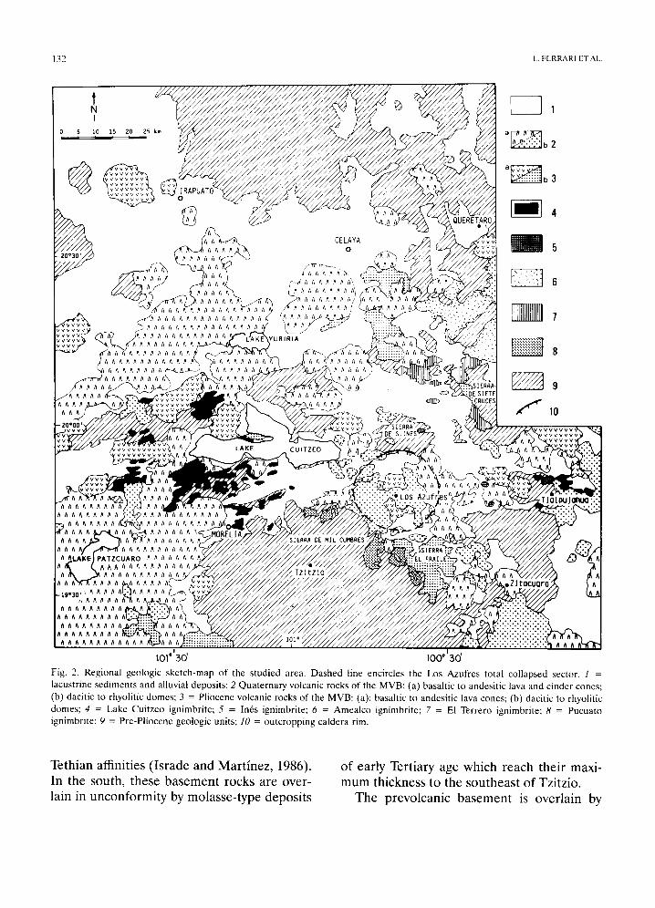
In the studied area, the Mesozoic and Eocene prevolcanic basement outcrops both in the north and in the south but it consists of different tectonostratigraphic assemblages. In the northern part of the area, sedimentary rocks of the Soyatal Fm., belonging to the Sierra Madre Oriental fold-thrust belt, out- crop at various sites north of Oueretaro and Celaya (Fig. 2) (Pasquar6 et al., in press). To the south, low-grade metamorphic sedimen- tary and volcano-sedimentary rocks of the Guerrero terrane (Campa and Coney, 1983) are exposed in the Tzitzio and Tlalpujahua areas, while near Zitficuaro the same rocks are thrusted on carbonate sequences bearing

GEOLOGY OF I_OS AZUFRES CALDERA, MEXICO: RELATIONSHIPS WITH REGIONAL TECTONICS 131
TABLE 1
New K-At age determinat ions in the Los Azufres Area
Sample Long. Lat. Material %K 4°Ar* 4°Ar* Agc Error (N) (W) dated aver. ( x l 0 t{) mol/g) (%) (Ma)
E1 Terrero Ignimbrite Mx 88-19 ~ 100.94 19.60 PI. 0.90 0.096 31.0 6.12 4-0.60
Sietc Cruces and El Fraile dome complex Mx 88-43 ~' 100.44 20.09 San. 6.02 0.568 33.0 5.45 ±0.50 Mx 88-28 ~' 100.47 19.63 Bio. 5.66 0.421 30.0 4.30 4-0.311
Amealco Ignimbrite Mx 88-22 a 100.80 20.36 PI. 1.11 0.074 11.0 3.83 4-0.40
Lake Cuitzco Ignimbrite Mor 4" 101.21 20. l 0 San. 3.02 2.162 61.0 2.8{) 4-0.20
Zinap,Scuaro rhyolitic domes Ar 5 I~ 100.80 19.85 W R 4.36 0.112 6.1 1.53 4-0.13 Ar 3 b 100.85 19.85 W R 4.16 0.089 18.6 1.21 4-0.04 Ar 4 t~ 100.85 19.88 W R 3.85 0.081 7.0 1.19 4-0.09 Ar 2 I~ 10(t.71 19.81 W R 3.91 0.079 16.3 1.14 4-0.04
Pleistocene basalts Mex 211 b 101.72 19.83 WR 1.67 0.022 4.4 1t.75 4-0.15 Mex 219 b 101.75 19.88 W R 1.41 0.022 3.4 0.87 4-0.17
All K-Ar ages are standardized to the decay constants recommended by Steiger and J~iger (1977). a Analyses performed at Instituto Mexicano del Petr61eo, Mexico City, in 1986 and 1988. b Analyses performed at Istituto di Geologia e Geofisica dell 'Universith di Napoli, Italy, in 1979. WR = whole rock; PI. = plagioclase; San. = sanidine; Bio. = biotite; 4°Ar* -= radiogenic 4°Ar.
TABLE 2
Selected published K-At dates of the Los Azufres area
Sample Rock type Long. Lat. Material Age Error Source (N) (W) dated (Ma)
Ls 23 Andesi te 100.91 19.65 WR 14.10 4-0.70 1 Az 20 *(a) Bas.-andesite 100.68 19.75 WR 10.20 4-0.60 2 Az 6 *(b) Andesite 100.66 19.76 WR 5.00 4-0.40 2 Az 211 *(c) Dacite 100.68 19.75 WR 3.10 4-0.20 2 443 Rhyolite 100.75 19.88 WR 1.60 4-0.15 1 - Rhyolite 100.63 19.81 WR 1.03 4-0.02 3
Andesi te 100.64 19.76 glass 1.03 4-0.20 3 - Rhyolite 100,64 19.76 WR 0.93 4-0.04 3
Rhyolite 100.66 19.80 glass 0.84 4-0.02 3 - Dacite 100,61 19.81 PI. 0.33 4-0.07 3 - Rhyolite 100.70 19.75 Bio. 0.30 4-0.07 3 - Rhyolite 100,70 19.78 Bio. 0.15 4-0.05 3
- Rhyolite 100,71 19.80 glass 0.14 4-0.02 3 452 Rhyodacite 100,38 19.53 WR 0.05 4-0.03 1
*Sample from geothermal wells: (a) depth of about 2700 m; (b) depth of about 700 m; (c) depth of about 800 m. Sources: 1 - Nixon et al. (1987); 2 - Aumen to and Guti6rrez (1980), in Dobson and Mahood (1985); 3 - Dobson and Mahood (1985).
£q U.I13[J~gAO Sl lUOtUOSeq a!UealOAOJd oqJ~ • o!zl!z I jo lseoqlnos aql o1 ssau>Ia!ql tuntu
-IXl3ttI .I.IOql q3130.I qa.tqA~ O~l~ +{.Ie.tla;gL ,{1.i13;9 jo
sl!sodop odfil-oSSelOtU fiq £l!tuaojuooun u! u!e I -JOAO OJe S)lOOJ lUOtUoseq osoql 'qanos oq] uI "(9861 'zou.~laelA! pug opeasI) so!l!u~e ue!qlo.L
• wIJ gJOpllg3 ~u!ddoJolno = Ol ~sl!un 3!gOlOO~ ouooO!ld-OJ d = 6 :ol!Jqlll!u~! olenond = 8 ".ol!Jqtll!u~! oJoJJOL l~t = / :o:l!Jqlil!u~! OOleOtu V = 9 '.ol!Jqw!u~'! sou I = £ !ol!Jqtu!u~! oozl!n D o~e 7 = p :sotuop
3!l!lO~qJ ol 3!1!3t~p (q) :souo3 eAg 1 3!l!sopue ol O!lleseq :(e) :SAIAI oql jo s)13oJ 3!ueoloA ouooo![ d = f ~somop 3!l!lofqa ol 39!3e p (q)
:souo3 Japti!3 pug I~At~[ 3!l!sopul~ O] 3!lleseq (~) :~[AIN oql lo s)DoJ 3!ue31OA fiJ~uJolenO C '.sl!sodop le!Anlle pug SlU0LU!p0s au!Jlsn:)l~ l = [ "JOlOOs posdellO3 1v, lol sojjnz V so-][ oql S~13J!3Ua aU!I poqse G 'goJe po!pms oql jo detu-qolo>lS 3!~OlOO~ [euo!~o~I E "~!_q
,0£ oOOt ,0£ otOt .~v v v ~'.'.'.'.'.'.'.'.'.'.'." vvvvvvvvvvvv • ,,,, • • ,/ ,,,,, • •
' 1 .iiiii!!iiii" :2:2:22::2 vvvvvvvv
VVVVVVV "':':::::::::::;:::i v v v v v v v v v
VVVVVVVV VV VVVVV"
VVVVV' VVVV
VVVVVVVV VV VVVVVVVvvVV
.~ V V V V V V V O~IYQ3ZIVd VVVVVVVV V
• { ;]~@wn~ llW 30 w~31s~ v v v v v v
vvvvvvvvvv vvvvvvv ::X~~ vvvvvvv vvvvvvVVVvvvvvvvv
O]ZIIN:) ])~VI
o,j
I , llIhIHIIII]tJl
• ,
mmI
8 q~e
q ,°,°.%"
CD CI~z~
/~V V' :VVVV
/VVVVVVVVV /VVVVVVVV [VVVVVVVV~ "\V V V V V V V ~ ~vvvvvy'
0
VAV73D
VVVV
~V V V V V'~"V~ j_ ~V V V VvVvVvVvVv v VVVVVV~v~VVV
VVVV VVVVVVVVVVVVV ~]~ VVVVVVVvVvVVV~
VVVVVV~v~v ~ VVVVVVVVVVVV
VVVVVVVVVVVVVVVV( VVVVVVVVVVVVVV VVVVVVVVVVVVVVU
~v
O
0': ~ 6 I
'IV d.3 IHVHH~:t "1 ~1

GEOLOGY OF LOS AZUFRES CALDERA, MEXICO: RELATIONSHIPS WITH REGIONAL TECTONICS 133
andesitic to rhyolitic lava flows, domes and pyroclastic products of Oligocene-Early Miocene age belonging to the Sierra Madre Occidental volcanic province (Pasquar6 et al., in press). These volcanic products are un- conformably overlain by a thick succession of Middle to Late Miocene basalts and an- desites which probably represents the basal part of the MVB. These volcanic rocks, which crop out extensively around Lake Cuitzeo and south of Quer6taro, also constitute the pre- Pliocene basement to the north (Sierra de S. In6s) and to the south (Sierra de Mil Cum- bres) of Los Azufres (Fig. 2).
Latest Miocene-Quaternary silic volcanic activ- ity in the Los Azufres area
Since latest Miocene time widespread sili- cic volcanism has occurred in the Los Azufres area with the emplacement of various ign- imbritic suites and pyroclastic flows and sev- eral dome complexes; they will be described in the following paragraphs.
El Terrero ignimbrite This ignimbrite, exposed to the north of
Los Azufres (Fig. 3), is a light brown medium- welded ash-flow tuff containing abundant pla- gioclase phenocrysts and small pumice lumps and scattered lithic fragments. Analyzed sam- ples (our unpublished data) range in composi- tion between quartz-andesites and dacites. A sample collected near the village of E1 Ter- rero, north of the Sierra de S. Ines, yield a radiometric age of 6.12 + 0.6 Ma (Ta- ble 1). Similar ignimbrites, exposed to the north and the east of Tlalpujahua (part of the Fm. Las Am6ricas of Fries, 1965), were tentatively correlated with the E1 Terrero ig- nimbrite on stratigraphic and volcanological criteria. In those places the E1 Terrero Ig- nimbrite is overlain by a younger ash flow with provenance from the Los Azufres area (Fig. 3, section VIII). In the northernmost outcrops the El Terrero ignimbrite is also cov-
ered by a younger ignimbrite which can be followed with continuity up to the Amealco caldera, located about 50 km northeast of Los Azufres. We obtained a radiometric age of 3.83 ± 0.4 Ma (Table 1) for a sample of the Amealco ignimbrite collected near the village of Sabanilla, some 25 km south of Quer6taro.
The El Terrero ignimbrite pinches out northeastward against topographical highs made of older rocks (Figs. 2 and 3) indicat- ing a provenance from the south or the west where it is covered by younger rocks. The only possible source in such direction is located in the Los Azufres area since the fault-bounded Lake Cuitzeo basin is a pure tectonic depres- sion (Gardufio et al., in press). If the corre- lations we made are correct, the El Terrero ignimbrite extends from Los Azufres for at least 60 km (Fig. 3). Known outcrops account for an area of about 170 km 2 with an average thickness of 30 m. Relying on these data, the volume estimate of the presently outcropping ignimbrite approximates 5.1 km 3. Extrapolat- ing the original extension of the E1 Terrero ig- nimbrite to the area inferred in Fig. 3 (about 1,000 km2), and maintaining the same thick- ness, the total volume would have been on the order of 30 km 3.
Pucuato ignimbrite This unit is widely exposed south of Los
Azufres but it is sometimes difficult to rec- ognize because its outcrops are often quite inaccessible and eroded. Its basal part, ob- served on the northern slope of the Sierra de Mil Cumbres, consists of a breccia 10-20 m thick, with blocks up to 1 m in size, com- prised of older rocks mostly andesitic in com- position. This layer is overlain by 15 m of a glassy, lithic-rich ash-flow tuff, pink in colour, and is capped by an air-fall deposits consisting mainly of pumice (80%) and millimetric an- desitic lithic fragments. The air-fall products reach a maximum thickness of 40 m in the Pucuato plateau, some tens of km south of Cd. Hidalgo. The Pucuato ignimbrite has not

134 1.. F E R R A R I ET A L
0 5 25kin / l - - ~ . , ~ _ . ~ X T l " I I I
Lake Yuriria
. ,~ .z . : . ! ! ! : i : ~ ! ! i : i i ! i " : :L . .~ • . • " " : ' : ' " ! : ! " : : : : ! : : : i : : : : . : :
i i i i i i i i i i i i i ! i i ! : ! : " v m
" ' : : : : : : : : : : ' : ........ ::::::" " . : : ~ , , , , = = _ ~ _ ~ t
I ~ . ~ re!i~.."05~ ! i .~ ~ " ~ r - ~ ' "~u-"~llllllJ~J[~ __../--/
A 101~x]' 100030 , I I
I II III IV V VI VII VIII IX
=: ~ : i : i i ! i ~ : i~'.~ : ~ t ~q7~'=7"~:77~':
", ~ ~ ~ . . . . . . ~ - - -~ -q . . . . . . . . . . 4 " . 6 . ]
. -~-~..~ ~ . . . . . . . . . _ - . .m . :)..= _ ~ _
v / v | m~._,~ - ° m ~
Fig. 3.(A) Sketch-map showing outcrops (a) and possible extension (b) of the pyroclastic units. Roman numerals indicate location of stratigraphic sections in Fig. 3B. 1 = Pucuato ignimbrite; 2 = El Terrero ignimbrite; 3 = Lake Cuitzeo ignimbrite; 4 = In6s ignimbrite; 5 = areal distribution of the Pueblo Viejo pyroclastic deposits: 6 = visible caldera rim; 7 = limit of the total collapsed area; 8 = inferred original limits of the ignimbritic sheets. (B) Representative stratigraphic sections (locations given in Fig. 3A). 1 = pre-volcanic basement: Mesozoic metamorphic rocks (a) and Cenozoic red beds (b); 2 = Miocene andesites; 3 = Pucuato ignimbrite; 4 = El Terrero ignimbrite; 5 = Late Miocene-Pl iocene lacustrine deposits; 6 = Lake Cuitzeo (a) and S. In6s (b) ignimbrite; 7 = lacustrine (a) and fluvial (b) deposits; 8 = Pueblo Viejo pyroclastic deposits; 9 = air-fall deposits with large pumice: 10 = Pleistocene basalts. Dotted and ruled areas represent the correlation of the various units. Not to scale.

GI!O|X)(;Y O | I.OS AZUFRI S ('AI Df~RA. MF~XI('O: I~,ILI.ATIONSIIIPS WITH RE(ilONA|~ Tf!('I 'ONI('S | 35
been radiometrically dated but can be related to the latest Miocene or Early Pliocene be- cause it overlies Late Miocene rocks but rests on topographic highs that remained from the Late Pliocene extensional tectonics.
The large size of the blocks, included in the basal breccia, point to a source area rel- atively close to the present outcrops. On the v~ther hand, no realistic source for this ign- imbrite can be found southward, in the highly dissected Sierra de Mil Cumbres (Fig. 2). We thus suggest as a probable source the La Venta depression, located south of Los Azufres (Fig. 4).
The present outcrops of the Pucuato ign- imbrite account for about 100 km 2 while the original extension is highly speculative (Fig. 3). Taking an average thickness of 50 m, the volume of the exposed rocks is 4.8 km 3. The original volume is very difficult to evaluate but could have been three times as much.
erupted in the dome complex of Sierra E1 Fraile is of considerable volume, being in the order of 100 km 3 (the maximum height of the complex is about 850 m and it covers an area of 180 km 2 approximately). A radiometric age of 4.3 ± 0.3 Ma (Table 1) was obtained from a dacitic sample collected at the locality of E! Dorado, 10 km ESE of Ciudad Hidalgo.
Near the village of Apaseo el Alto, 30 km WSW of Quer6taro (Fig. 2), several large ex- ogenous domes are present. They are made of highly altered devitrified rhyolite with a marked fluidai texture and are almost free of phenocrysts. The Apaseo domes are em- placed above a basaltic plateau dated between 8 and 6 Ma and are overlain by small basaltic shield volcanoes of Pleistocene age; conse- quently we suppose that the Apaseo domes were emplaced during the Early Pliocene as in the case of the Siete Cruces and E1 Fraile complexes.
Siete Cruces, El Fraile and Apaseo dome complexes Various dome complexes, unrelated to
caldera structures or volcanic centres, are present in the area surrounding Los Azufres. The southwestern side of the Sierra de Siete Cruces (Fig. 2) mainly consists of rhyolitic flows made of rare phenocrysts of quartz, oligoclase and sanidine in a glassy matrix. The rhyolites were probably part of a complex of exogenous domes that have been highly eroded and partly covered by younger rocks. Sanidine phenocrysts from a sample collected near the village of Puroagua, on the south- western slope of the Sierra de Siete Cruces, yielded a K-At age of 5.45 ± 0.5 Ma (Table 1 ).
The Sierra El Fraile, south of Los Azufres, consists of a large complex of coalescing en- dogenous domes; deposits of hot avalanches have been observed locally. The rocks are typically dacites with phenocrysts of horn- blende, biotite and sodic plagioclase in a glassy groundmass containing plagioclase mi- crolites. The amount of differentiated magma
Lake Cuitzeo ignimbrite The main exposures of this unit are around
Lake Cuitzeo, where it covers a Late Miocene succession of andesites and basalts, and near the city of Morelia (Fig. 2), where it has been exploited as a building stone. This ignimbritic suite presents different facies, varying from a gray or violet, glassy welded ash-flow tuff to an almost unconsolidated white ash flow. South of Lake Cuitzeo, the ignimbrite con- sists of two main eruptive units separated by about 10 m of lacustrine sediments. The lower unit is characterized by various poorly welded ash flows with thin layers of air-fall ash. The upper unit consists of pink to violet ash-flow tufts with phenocrysts of quartz, sanidine, pla- gioclase and few orthopyroxenes with rare lithic and pumice fragments up to 1 cm in size. The sequence is capped by alternating layers of ash, pumice and lacustrine siltstones. Northwest of Lake Cuitzeo, only the upper ignimbrite unit is found. It is welded with rare phenocrysts of quartz, sanidine and andesine plagioclase and collapsed pumice ranging up
136 I FI~%RRARI ET AL.
to 10 cm in length. Sanidine crystals from a glassy ash-flow tuff north of Lake Cuitzeo yielded a radiometric age of 2.8 + 0.2 Ma (Ta- ble 1). To the west of Lake Cuitzeo the ign- imbrite is covered by Late Pleistocene basaltic flows, making precise determination of the actual extension impossible. We estimate the original extension to have been nearly 2,000 km 2 (Fig. 3), with an average thickness of al- most 40 m. Therefore, the probable original volume is on the order of 80 km 3.
S. InOs ignimbrite The unit is exposed in scattered outcrops in
the Sierra de S. In6s and northwest of Tlalpu- jahua (Fig. 2). In the former site the ign- imbrite rests unconformably on Late Miocene andesites which are tilted up to 10 ° toward the north, while in the latter area it overlies an older ash-flow deposit tentatively correlated with the E1 Terrero ignimbrite. The ignimbrite consists of two eruptive units. The lower one is a light gray or light brown tuff up to 25 m thick with black fiamme up to 50 cm long which contain perlite. Lithic fragments con- sists of angular blocks (up to 20 cm in size) of older andesites and dacites and are diffusely distributed in the tuff. This body is capped by 3 m of a brown welded tuff with small white pumice. A few meters of an air-fall de- posit are sometimes observed on top of the ignimbrite. A correlative ignimbritic sequence is found in the Tlalpujahua area, resting on a lacustrine deposit with diatomaceous sedi- ments of Late Miocene age (Gardufio, 1988). In this area the ignimbrite is 10 m thick. The estimate of the actual exposures approach 45 km 2 while its volume amounts to 1.3 km 3.
Zinap~cuaro domes This unit consists of several isolated domes
emplaced around the village of Zinap6cuaro, between Los Azufres and Lake Cuitzeo (Fig. 4). Hot avalanche deposits, produced by the breaching of the carapace, are sometimes ob- served. The lavas are light gray, flow-banded
rhyolites, rich of obsidian and with well devel- oped spherulites. The domes vary in compo- sition from rhyolites to high-silica rhyolites, with quartz, K-feldspar and plagioclase as main components. The Zinap6cuaro domes yielded K-Ar ages ranging between 1.6 and 1.14 Ma (see Tables 1 and 2).
Los Azufres volcano and summit domes Andesitic aphanitic lavas outcrop to the
north and to the south of Los Azufres (Fig. 4). These rocks were previously interpreted as resurgent "basement" rocks, chronologically equivalent with the Sierra de S. In6s ones (Pradal and Robin, 1985). Nevertheless, the dating of these lavas to the Pleistocene (Table 2; Comisi6n Federal de Electricidad (C.EE.) unpublished data) and the fact that they gen- tly dip in opposite directions, support a dif- ferent interpretation (Pasquar6, 1986). In our view, these andesites represent the northern and southern slopes of a lava cone of Pleis- tocene age covered for the remaining part by younger domes. K-Ar dates of samples collected in the geothermal drillings at Los Azufres (Table 2) suggest a thickness of about 700-800 m for the andesites belonging to the volcano which, at least in its southern part, seems to lie upon an ignimbrite unit dated 3.1 Ma (Gardufio, 1988). The summit area of the Los Azufres volcanic centre, where the geothermal field is located, is occupied by two large exogenous domes emplaced be- tween 1.03 and 0.84 Ma (Table 2), whose to- tal volume was estimated to be 10-15 km 3 (Dobson and Mahood, 1985). Lavas are rhy- odacites and rhyolites with fluidal texture and contain phenocrysts of plagioclase, sanidine, quartz and biotite. Rocks are locally very al- tered due to the persistant hydrothermal ac- tivity related to the geothermal system.
Dacitic domes The Cerro S. Andr6s, located just to the
east of Los Azufres, is a large vent com- plex which produced two thick flows and rep-

G E O I . O G Y O F L O S A Z U F R E S C A L D E R A , M E X I C O : R E L A T I O N S H I P S W I T H R E G I O N A L T E C T O N I C S 137
Vie
napecuaro
~,zxtx~zx~x~xt, zx zx
Valle de Juarez
/ \
+vv
v v v v v v v v v v v v v v . . . ~ . . ~
v v v v v v v v v , v . . - . . . . . . . - • %L . . . . . ! ~ ( ~ v ~ l ; : ~ . . . . . . . . . . . . . . . . . . . ~ . , ~ ~ . ~ . i ! i i ~ . ~ v v v v v v vvvv / v ...- -...........
x x v v v v v v v . . . . . . . . . . . . . . . . . . . - . . . . .
~ ~ " ~ ~ i ~ : : i : i : ! : ! : ! : ! : ! : ! : i : i : ? : ? : ! ~ j . . ~ iL~Azufres ;!:!:!:i:i:i:i:i:i:i:i:!
12 .~.227~ ~ ~... . . . . . . . . . . . . . . . .~ ~ " " " " : " " " : : : : : : : : : : : : : : : ~
~ ? ~ : : : : ,"-~: ~ ~!:i:!!!!!i!i!iiiiiiiiiiiiii!~
19°55 '- \
\ t ,19o50 '-
, 1 • !
v v v ° O o O ° o o ° o ° ° o ° oo~ .~°o • ooo oo ° o g ~ . ~ . o
~ ........ / Ciudad Hidalg ~~
N 0 2 4 km
ka Venta iooo~o , I ~
Fig. 4. Geo logy of the Los Azuf res area. 1 = al luvial deposi ts ; 2 = pyroclas t ic depos i t s r e l a t ed to the la te P le i s tocene domes; 3 =
La te P le i s tocene rhyol i t ic domes; 4 = Cer ro S. Andrds and r e l a t ed daci t ic domes; 5 = P le i s tocene basa l t ic c inder cones and flows;
6 = f luvio lacus t r ine depos i t s par t ia l ly m a d e of pyroclas t ics r e l a t ed to the Z i n a p d c u a r o domes; 7 = Ear ly P le i s tocene rhyol i t ic
domes; 8 = Los Azuf res volcano; 9 = lacus t r ine sed iments ; 10 = Pucua to ign imbr i te ; 11 = La te Miocene andes i tes ; 12 = c inder
cones; 13 = domes ; 14 = norma l faults; 15 = obl ique slip faults; 16 = f rac ture or faul ts with u n d e t e c t e d mot ions ; 17 = visible ca lde ra rim; 18 = infer red total co l l apsed area.
resents the major peak of the Los Azufres area. It covers an area of about 70 km 2 and the volume is estimated in 15-20 km 3. Lavas are dacites and rhyodacites with phe- nocrysts of plagioclase and hornblende; inclu-
sions of aphyric andesites are often present. An age of 0.33 + 0.07 Ma was obtained for the S. Andr6s dacites (Table 2). Southeast of Cerro S. Andr6s there are small satellite domes of similar composition. Cerro Mozo,
138 I FFRRARI ['T AI..
another dacitic dome located 12 km WNW of Cerro S. Andr6s, is composed of a glassy lava with small phenocrysts of andesine, quartz and oligoclase. Radiometric dating (C.EE., unpublished data) of this dome, yielded ages comparable with the one obtained for the Cerro S. Andr6s. The Cerro Mozo is sur- rounded by a thick blanket of pyroclastic de- posits probably related to its evolution.
Pueblo Viejo pyroclastic flows Under this heading we group several py-
roclastic flow deposits cropping out in the southern part of the Los Azufres depression and which display their maximum thickness near the village of Pueblo Viejo (Fig. 4). In this area the succession consists of three pumice flows. The basal unit is characterized by the presence of black pumice and andesitic fragments and is overlain by a 80-cm-thick pa- leosoil. A second pumice flow is distinguish- able because of a glassy matrix and the pres- ence of charcoal fragments. The sequence is capped by a third flow with rhyolitic pumices up to 25 cm long. South of Los Azufres sim- ilar flows are underlain by surge deposits. These deposits are presumably Middle Pleis- tocene in age because they rest on a basaltic andesite flow dated at 0.87 ± 0.17 Ma (Table 1). Another very recent pyroclastic deposit is found around the town of Acfimbaro, located northwest of the Sierra de S. In6s. It consists of an air-fall deposit overlain by a basal surge and an ash flow containing pumices, obsid- ian and andesite fragments. The lower part of the sequence is deposited in a paleolacustrine depression.
Recent domes Many rhyodacitic to rhyolitic domes are
emplaced in wide areas southwest of Los Azufres and represent the youngest eruptive event in the area. The lavas are very glassy with few phenocrysts of plagioclase and sani- dine. Three domes yielded K-Ar ages ranging
between 0.30 and 0.14 Ma (Table 2); a more recent age of 28.000 years (Gardufio, 1988) was reported for a pyroclastic deposit related to the Guangoche dome, located in the most southwestern part of the area. This dome con- sists of a large crater almost completely filled by another small dome. The crater was proba- bly the result of an explosive event which pro- duced a blanket of pumice and ash deposits up to 25 m thick in this area. Late Pleistocene silicic volcanism is also widespread outside the Los Azufres area where an age of 0.05 Ma (Table 2) was reported for a rhyodacitic dome north of Zit~.cuaro (Fig. 2). East of this town, a large complex of rhyolitic domes of very recent age with associated thick pyroclastic deposits is also present.
Fluviolacustrine deposits
Two main depressions represent the mor- phological evidence of the Los Azufres caldera system: a northern depression (Valle de Jufirez), limited to the north by the Sierra de S. In6s massif and a southern one (La Venta depression), bounded to the south by the Sierra de Mil Cumbres massif. These de- pressions were filled by epiclastic fluviolacus- trine deposits made of moderately consoli- dated, thin layers of siltstones and ashes with horizons containing pumice, obsidian and an- desite fragments. In the Valle de Jufirez de- pression, near the village of S. Ildefonso, these sediments unconformably overlie the Late Miocene andesites of the Sierra de S. In6s and just to the east they are covered by the Middle Pleistocene basaltic flows of Cerro La Calabaza. In the La Venta depres- sion, near the village of Huajfimbaro, the sed- imentary deposits consist of two sequences of conglomerates, tuffaceous sandstones, silt- stones and diatomites overlain by recent pyro- clastic deposits. The lower succession is tilted 25 ° to the south, suggesting the existence of two main tectonic events.

GtiOI.O(iY OF LOS AZ{ FRHS CALDERA. MEXICO: RELATIONSHIPS WITH REGIONAl. TECTONICS 139
Pleistocene basalts
Various basaltic flows crop out in the out- skirts of the Los Azufres depressions. They have mostly a microcrystalline texture with plagioclase, clinopyroxene and magnetite mi- crolites. Southwest of the village of Ucareo, in the Valle de Jufirez depression (Fig. 4), one of these basaltic flows covers Early Pleis- tocene rhyolitic flows coming from the Mesa Grande dome (Zinap6cuaro domes). A sam- ple collected in place gave a radiometric age of 0.75 ± 0.15 Ma. Another basaltic sam- ple collected about 5 km to the south, near the Morelia-Maravatio road, yielded a com- parable age of 0.87 + 0.17 Ma (Table 1). Basaltic volcanism of Middle Pleistocene age is widespread in the region west of Los Azufres (Hasenaka and Carmichael, 1985) and also along the southeastern shore of Lake Cuitzeo where several cinder cones, with a marked E - W alignment (Pasquar~ et al., in press), overlie pyroclastic deposits related to the Zinap6cuaro domes. To the east of Los Azufres, many basaltic cinder cones, which appear morphologically younger, are aligned along E - W and NW-SE trends.
Regional tectonics
Structural architecture
The regional structural architecture is dominated by an impressive extensional fault system which forms a continuous succession of grabens and semigrabens (Fig. 5). De- pressions are limited by en-echelon dog-leg faults striking from E - W to NE-SW (Tibaldi, 1989). Volcanic and sedimentary successions are tilted mainly south-southeastward, ac- cording to the NNW principal fault dip. Per- vasive secondary faulting parallel and perpen- dicular to the graben elongation also disrupt the tilted blocks. En-echelon structures show an E - W line of bearing which gives rise to the general E - W elongation of the exten-
sional pattern of the area, These structures link the Tzitzio high, in the southern part of the area, to the Celaya-Quer6taro depression in the north (Fig. 5). The Tzitzio high is a moderately asymmetrical open anticline with a NNW-SSE 100-km-long axis, involving the metamorphic basement and the Palaeogene- Early Miocene volcano-sedimentary units. Multiphase folds with different orientations are widespread in the Tlalpujahua area, east- southeast of Los Azufres. Compressional structures are also expressed by thrust, re- verse and strike-slip faults with a variety of orientations. This complex distribution of brittle features is due to the juxtaposition of several tectonic phases.
Tectonic phases
Pre-Pliocene tectonics Metamorphic basement was involved at
least in two folding phases of post-Jurassic age following noncoaxial directions of short- ening. Radiometric age determinations and stratigraphic relationships constrain the de- velopment of the Tzitzio anticline to the end of Early Miocene (Ferrari et al., 1990).
Following this compressional event, N-S- trending Basin-and-Range extensional struc- tures developed in the northern part of the area (Pasquar6 et al., 1988). Most of these structures were buried by the subsequent vol- canic activity, and precise temporal location of this phase requires further investigation.
Late Miocene-Early Pliocene tectonics Up to the beginning of the Late Miocene,
rock units are displaced by rare N 25°-45 ° right-lateral and by several N 60°-75 ° left- lateral en-echelon strike-slip faults. These sets of faults can be conjugated in a system with an acute angle ranging between 30 ° and 90 ° (Fig. 6A). Motions are characterized by pitches of less than 45 ° while the dip of the fault planes ranges between 65 ° and 90 ° . The same rock units are also disrupted by rare N

1 4 0 L F E R R A R I ET A L .
,0,%.
> Y J
/ / @
I rapua to
/
~.4~ Z, ,,,. '°"°* [ t '*'°*
\
Lake Yuriria / ~ /
~'>,d(~'/ ~ - ~ " ' ~ / L a k e Cu,tzeo ,~,, ~ --r- ~
Lake Patzcuaro ~ ~-
\
. . ~ ~ " ~ - . ~ / / × ~-x-~ ~K'-".,<
/ / ---- / \-, , \,,
LEGEND
~ . . . . . . . 2
~ . . . . . . 3
~ 5
\
o
20~00'.
"4'
Zitacuaro
Fig. 5. Reg iona l s t ruc tura l m a p and l imi t of the total co l lapsed area of the Los Azuf res nes ted ca ldera (dashed line). 1 = s t r ike-s l ip
fault; 2 = lef t - la tera l no rma l fault; 3 = pure no rma l fault; 4 = mas t e r jo in t or faul t with unde t ec t ed mot ion vector; 5 = ou t c ropp ing Los Azuf res ca lde ra rim: 6 = Tzi tz io ant ic l ine.
GIz.OI.OGY OF LOS A Z U F R E S ( ' A I . D E R A , M E X I C O : R E I . A T I O N S H I P S W ITH R[sGIONAI T E C T O N I C S 141
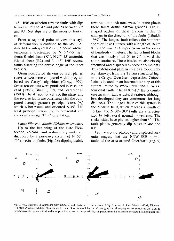
145°-160 ° en-echelon reverse faults with dips between 35 ° and 70 ° and pitches between 75 ° and 90 ° . Net slips are of the order of tens of c m .
From a regional point of view this style of deformation is confined to the MVB. All data fit the interpretation of Pliocene wrench tectonics characterized by N 600-75 ° syn- thetic Riedel shear (R1), N 250-45 ° antitethic Riedel shear (R2) and N 145°-160 ° reverse faults bisecting the obtuse angle of the other two sets.
Using nonrotated slickenside fault planes, stress tensors were computed with a program based on Carey's algorithm (Carey, 1979). Stress tensor data were published in Pasquar6 et al. (1988), Yibaldi (1989) and Ferrari et al. (1990). The strike-slip faults of this phase and the reverse faults are consistent with the com- puted average greatest principal stress (crj) which is horizontal and oriented N 49 °. The least principal stress (~r3) is horizontal and shows an average N 139 ° orientation.
Latest Pliocene-Middle Pleistocene tectonics Up to the beginning of the Late Pleis-
tocene, volcanic and sedimentary units are disrupted by a pervasive system of N 60 °- 75 ° en-echelon faults (Fig. 6B) dipping mainly
towards the north-northwest. In some places these faults define narrow grabens. The S- shaped outline of these grabens is due to changes in the direction of the faults (Tibaldi, 1989). The longest fault follows the southern shore of Lake Cuitzeo, with a length of 16 km while the maximum dip-slips are in the order of hundreds of meters. The faults limit blocks that are mostly tilted 5 ° to 20 ° toward the south-southeast. These blocks are also closely fractured and displaced by secondary systems. This extensional pattern creates a topograph- ical stairway, from the Tzitzio structural high to the Celaya-Quer6taro depression. Cuitzeo Lake is located on an intermediate step of this system limited by WSW-ENE and E - W ex- tensional faults. The N 80°-10 ° faults consti- tute an important structural feature: although less developed they are continuous for long distances. The longest fault of this system is the Morelia fault, which reaches a length of 15 km. The N 60°-100 ° faults are character- ized by left-lateral normal movements. The slickensides have pitches higher than 50 °. The fault planes generally dip between 46 ° and 80 °"
Fault scarp morphology and displaced rock units suggest that the NNW-SSE normal faults of the area around Quer6taro (Fig. 5)
North
A
15 12 9 6 3
North 15
[3 12
60 /*0 36 2L,
t 60
/*0
36
North
1 0 8 6 / . 2
+6
O"
Fig. 6. Rose diagrams of azimuthal distribution of fault strike active in the area of Fig. 5 during: A. Late Miocene-Early Pliocene, B. Latest Pliocene-Middle Pleistocene, C. Late Pleistocene-Holocene. Converging and diverging arrows represent the average directions of the greatest (or 1 ) and least principal stress (e3) respectively, computed from the inversion of striated fault populations.

142 I l i R R A R I I I A I
were active at least during the Early Pleis- tocene. This grid-like fault distribution caused a block structure with tilting in various direc- tions. We believe that the motions along the NNW-SSE system represent the reactivation of older fault planes which are widely devel- oped to the north of the area of study. On the whole, the data agree with the development, in the Latest Pliocene-Middle Pleistocene, of left-lateral transtensional tectonics following an E - W divergent wrenching zone (in the sense of Wilcox et al., 1973).
The computed stress directions agree with an average value of N 149 ° for a c~ lying on an horizontal plane and fluctuating between N136 ° and N165 °. Generally, the direction of or3 is oblique to the fault planes.
Late Pleistocene-Holocene tectonics The limited number of good exposures al-
lowed us to study only a few structural sites in rock units of Late Pleistocene-Holocene age. The collected data are consistent with the presence of normal and left-lateral normal E-W-trending faults (Fig. 6C). Dips range between 55 ° and 80 ° and pitches are greater than 78 °. This suggests that a slightly oblique extensional tectonics is taking place (Fig. 8), in accordance with the left-lateral normal mo- tion along the E - W fault plane of the Acam- bay earthquake of 1912 (Astiz, 1986). Stress tensor solution gives an horizontal c~: and cry. Strike of cr~ ranges between NNW-SSE and N-S (Fig. 8).
The last three tectonic pulses, dating from Late Miocene to the present, were grouped in a unique deformation cycle characteristic of an E - W left-lateral shear zone (Pasquar6 et al., 1986, 1988; Ferrari et al., 1990). The Late Miocene-Pliocene strike-slip faulting was generated by the first pulses of the incip- ient shear zone related to parallel wrenching, while the Quaternary deformations represent the surficial expression of the development of the shear zone with movements of divergent wrench type. Quaternary left-lateral transten-
sion agrees very well also with seismic (As- tiz, 1986) and paleomagnetic data (Urrutia- Fucugauchi and B6nhel, 1988).
Tectonics o f Los Azufres area
Caldem rim, fault pattern and stress .field
A possible caldera rim is only present to the north of Los Azufres, where it is marked by a curvilinear eroded fault scarp and other parallel secondary fault scarps (Fig. 4). The collapsed area can be only encir- cled inside a circular feature corresponding to the abrupt disappearance of andesite rocks of the Miocene basement. On the north- ern side of this circular feature, the Late Miocene andesitic rocks of the Sierra Santa In6s (Figs. 2 and 4) abruptly terminate against the curved fault scarps and are encountered only at depth in the geothermal wells of Los Azufres (Guti6rrez and Aumento, 1982). On the southern side, the Middle Miocene rocks of the Sierra de Mil Cumbres disappear along a circular eroded scarp with a northward con- vexity. Radial fractures are widespread for the majority in the Sierra de Santa ln6s, resem- bling the typical radial structures of the early stage of development of a caldera (Smith and Bailey, 1968; Gardufio, 1988). Caldera rim and radial structures disappear at the con- tact with the dome complex cropping out NW of Ucareo (Zinap6cuaro domes, 1.6 Ma, Ta- ble 2) and with Pleistocene basaltic flows east of Valle de Jufirez (Fig. 4). These are the only data which permit to infer a geometry to the caldera. Taking into account that inside this depressed area sediment thickness is not con- stant with our circular feature, we intend to limit the maximum extension of what might be a nested caldera. An higher geometric res- olution of the various collapsed sectors is im- possible to obtain at the present state of art and probably also in the future because of the extensive recent volcanic cover and tectonics. Therefore, we will simply call this circular ex-

( ;I OI .O( ;Y O t I .OS AZUF:RI S ( ' A L D E R A . M E X I ( O : REI_,\'I IONStt lPF, WII In Rt{( ; IONAI. [ I ( ' T O N I ( ' S 143
pression of a nested caldera the Los Azufres caldera.
Several E N E - W S W and E - W normal faults cut volcanic rocks dating up to the Late Pleistocene (Fig. 4). In particular, an E - W fault swarm can be recognized from Los Azufres area to the south of Zinapdcuaro and from Valle de Jufirez eastwards. These faults, which appear to be younger than the caldera, are part of a regional system, as can be seen by comparing the N 50°-90 ° orientation of these faults (Fig. 8) with the dominant az- imuth of the regional Quaternary ones (Figs. 6 and 7). The main fault of the Los Azufres area is an E-W, l-km-long normal fault and dipping northward. It lies 3.5 km north of the Los Azufres geothermal field and belongs to the main parallel fault swarm affecting the in- ner side of the caldera (Fig. 8). In this swarm there are 6 main E - W north-dipping normal faults and two antithetic south-dipping nor- mal faults. The two antithetic faults bound the central graben of Los Azufres. Three sym- metric grabens of second order are present more to the west-southwest. Two other main faults strike N-S, disrupting a tilted block lim- ited to the south by the principal 1 l-km-long fault. This fault swarm is not directly linked with the normal faults outside the caldera but lies exactly on their continuation (Fig. 4). An E - W normal fault located 10 km NNE of the Los Azufres geothermal field dips north- ward inside the caldera, but at its eastward apparent continuation the dip changes south- ward (Figs. 4 and 8). The type of motion of the Los Azufres faults (normal with a slight left-lateral component) , and their dominant northward dip are in agreement with the characteristics of the regional system.
If these N 50°-90°-trending faults are in- dependent from any caldera collapse, it is expected that the orientation of the Quater- nary stress field inside the caldera equals the regional one. Measurements of 35 striae on Quaternary fault planes were collected within the caldera (Fig. 8). As seen from the stere-
,o1'-o~o, , 0 , ' ~ ' ' ' 100940 ' 100~20'
_ ~ . . . . . ~ ~ \ ~L * 50km ,
• . . . .
2o~' * ~ I ~L. -
\ ~ . . . . . . ~ - . . . . . ~ . -
-~ \ , ...... e-- .... r - ; I , , \ f - - ~ ..-.-4 . . . . . 4.1.,_
>,'l" t .-v • " ~ . . . . v - -
_..~..~ .T ' ~ •
LATE PLEISTOCENE-HOLOCENE
O l
Fig. 7, Regional strcss field for the late Plcistocene-Holocene period. Dashed lincs and dotted lines rcpresent mean orien- tation of O-}lmm and (rHma x respectively; heavy black segment shows local orientation of O'Hm m as deduced from inversion of microtectonic data; black dots are localities shown in Fig. 5. Block diagram represents the deformation mechanism for the same period (after Ferrari ct al., 1990).
oplot, motion surfaces strike from E - W to E N E - W S W with pitches ranging between 70 ° and 90 °. These data were processed with a computer program following Carey's method (Carey, 1979) in order to obtain the stress orientation. Computat ion of stress orienta- tions consistently produced horizontal c7~ val- ues oriented from N 165 ° to N 180 °, in agree- ment with the Late Ple is tocene-Holocene re- gional stress field (Figs. 6C and 7).

144 I . F | £ R R A R I E T A L .
, i i i .
il184- i ' " ' ' " i
6 5 t . . . . . t . . . .
I I I I • • I J
i i i i "
ZO~ ~ I MEX 1 3
/
LOS AZUFRES
• • . ~ 4 9 /
' ' I ' l 0 /
75 "65 ~ . . . / z . \ , i • ~ " \ \ \
\, / ' , \
I I I I _ _ MEX12
Fig. 8. Structural map of main faults inside the caldera. Numbers denote fault plane rake. Main and secondary fault planes and motion vectors detected at four structural sites are plotted as lower hemisphere projection on Schmidt stereograms. Divergent large arrows show computed directions of the least principal stress (0-3).
Several perturbations in regional structural trends may be explained by the presence of a caldera. A few E - W faults change their dip or present some degree of strike vari- ation when crossing the caldera rim. Struc- turally aligned volcanic features appear to change in composition when approaching the caldera rim. Monogenetic basaltic cones are
widespread both to the east and to the west of the caldera, but they are very scarce inside it, where dacitic to rhyolitic domes are dom- inant. These complications could be related to the interaction between the regional tec- tonics and the silicic magma chamber existing below the caldera. The effect of the regional ~r3 could have been reduced by the anomalous

GEOLOGY OF LOS AZUFRES CALDERA, MEXICO: RELATIONSHIPS WITH REGIONAL TECTONICS 145
rheology produced by partially molten rock in the chamber. Regional faults maintain their average strike but develop only at shallow lev- els in the more brittle rocks lying above the magma chamber.
This postcaldera regional episode of nor- mal faulting is responsible for the obliteration of the caldera rim geometry.
Age of postcaldera faulting
Regional E - W faulting developed in the central sector of the Mexican Volcanic Belt since the Pliocene. Inside the caldera, rocks dating up to the Middle Pleistocene were affected by the E - W faults, while domes younger then 0.3 Ma are not. Seismological data (Suter et al., 1989) show that only some segments of the regional system east of the caldera are active. In fact, seismic activity was recorded on the Acambay fault segment dur- ing 1912 A.D., and on the Maravatio fault segment during 1979. A minor seismic event was also felt by people living in the surround- ings of Los Azufres at the beginning of this century but it did not produce detectable field deformations (Suter et al., 1989). According to these data we can suppose that a low level of activity, if any, took place along the Los Azufres E - W fault segment during the Late Pleistocene-Holocene.
Discussion and conclusions
The Los Azufres area presents an unusual concentration of silicic volcanic activity inside the Mexican Volcanic Belt since the latest Miocene. Its long geological and structural evolution is also peculiar if compared with the other silicic centres of the MVB (Verma et al., 1991, this issue) characterized by a relatively short period of activity.
The recognition of four large ignimbrite sheets surrounding the Los Azufres area sug- gests a long history of caldera collapses, al- though the precise location of these struc-
tures is difficult to identify because of the successive tectonic and volcanic activity. The Pleistocene silicic centres can be enclosed within a relatively depressed area constituted by the Valle de Jufirez and La Venta depres- sions surrounded by Miocene andesite rocks (Fig. 4). The Valle de Jufirez depression is limited to the north by a semicircular fault scarp which may represent a caldera rim. Structures related to the northern caldera rim are presumably buried under rhyolitic domes dating back to the Early Pleistocene. The southern side of the La Venta depression is represented by a roughly semicircular align- ment of rhyolitic and dacitic domes of Late Pleistocene age and by the limit of the Middle Miocene andesites of the Sierra de Mil Cum- bres. These two semicircular features encir- cle a depressed area where geothermal explo- ration drillings encountered an anomalously thick, Late Miocene-Early Pliocene volcanic sequence. Around this depression four large ignimbritic sheets were recognized. The large volumes of these pyroclastic flows rule out their provenance from a dome complex. On the other hand, there does not exist any al- ternative caldera source for these flows in a radius of 200 km. The only already known Amealco caldera, which lies 100 km NE of Los Azufres, is the source area for a fifth ign- imbritic sheet which is clearly distinguishable from the ones described in this work.
All these observations support the basic conclusion that multiple caldera collapses oc- curred during pre-Quaternary times inside the circular depressed area of Los Azufres. Recent volcanic and tectonic activity unables us to assess a precise geometry of the var- ious collapsed sectors and their related ign- imbrites. We thus suggest that Los Azufres is a nested caldera and we limit ourselves to consider the whole depressed area. The total original volume of the ignimbrites was esti- mated to be 130 km3; this value is comparable with the volume of the total collapsed area, which can be roughly estimated in 180 km 3

146 1. I:[iRRARI tiT AL.
(taking an area of 450 km2 and a collapse of 400 m).
On the contrary, it is not possible to com- pare the volume of the pyroclastic deposits related to the caldera collapse with the vol- ume of their proposed caldera according to Pradal and Robin (1985). In fact, even consid- ering the maximum thickness (80 m) and the areal extension reported by Pradal and Robin, the volume obtained for these pyroclastics is about 12 km 3. By contrast, they proposed a caldera 20 × 15 km in size and a collapse of at least 400 m which give a volume of about 90 km ~. In addition, they proposed that the products of the Los Azufres Volcano, which rise at the southern limit of their caldera, have the same age of the andesites of the Sierra de S. Inds, thus supporting a resurgent caldera model. Nevertheless, this inference can be questioned since andesites outcrop- ping at Los Azufres were dated at 1.03 ± 0.2 Ma (Table 2) while Late Miocene rocks were encountered only down a depth of about 700 m. Finally, geothermal wells at Los Azufres reach the depth of -3544 m (Venegas et al., 1985), without encountering the prevolcanic basement. These data permit to consider the Los Azufres structure as a latest Miocene and Pliocene nested caldera and to refute the Late Pleistocene resurgent caldera model of Pradal and Robin (1985).
Considering the age distribution of dated volcanic products of the area comprised in Figure 2 (Fig. 9), we can observe that the acid activity, occurring between 6.2 and 2.8 Ma in the Los Azufres region, is partly coincident with a gap (5 to 3 Ma) in basic and inter- mediate volcanism. These data appear to be coherent with the beginning of a left-lateral shear zone characterized by a Late Miocene- Pliocene first pulse with transcurrent faulting and a latest Pliocene-Quaternary transten- sion. The gap may be explained by storage of magma during the compressive pulse, with consequent differentiation and uprising along transcurrent faults.
0 5 1 5 3 5 4 5 5 5 6 5 7 5 8 5 9 =) ~ 0 5 1 1 5 ' 2 5 1 3 5 1 4 . 5
Age ( 'v'.c )
Fig. 9. Histogram of K-Ar age dates of the central part of MVB between longitude 100°W and 102°W. Mafic to inter- mediate dated rocks are black; silicic dates rocks are shaded. (Data from Aumento and Guti~rrcz, 1980; Dobson and Ma- hood, 1985: Venegas et al., 1985; Nixon et al., 1987; Pasquar/z et al. in press; this work, and our other unpublished data.)
The volcanological consequence of the following transtension on the Los Azufres caldera is represented by mixing of new basaltic magmas with the remaining differ- entiated ones; petrographical evidence for such mixing was reported by Demant (1981) and Chatelineau et al. (1987). Large amounts of basaltic lavas were erupted outside the caldera rim along the main extensional faults. The offset produced by the transtensional phase and the Quaternary volcanic activity in the Los Azufres caldera, contributed to oblit- erate its original geometry at the point that what is probably the largest caldera structure of the MVB is also the more difficult to be understood.
Acknowledgments
We are indebted to M. Ferrari and L. Vez- zoli, who cooperated in the geological inves- tigations in the area. We are also grateful to E Innocenti for useful discussions dur- ing an early stage of the preparation of the manuscript. The original version of the pa- per was improved by two anonimous review- ers of JVGR. S.R Verma also provide useful
(iEOI.O(;Y OF LOS AZUFRE5, CAI DERA. MEXICO: REt.ATIONSHIPS WITH REGIONAL TECTONICS 147
suggestions. This work is part of a research project over a larger area, sponsored by the Ministero Italiano della Pubblica Istruzione, 40% grant. V.H.G. benefited from a Third World Academy of Science grant; A.T. bene- fited from an Italian Ph.D. grant. Line draw- ings were prepared by M. Minoli. The English style was reviewed by A.J. Aghib.
References
Aumento, E and Gutidrrez, N.A., 1980. Geocronolog{a de Los Azufres, Michoacfin. Intern. Rep. of Comisi6n Federal de
Elcctricidad, Mexico City, 15 pp. Astiz, k., It,~86. Thc 1912 Acambay, Mexico (Ms = 7.0)
earthquake: A reexamination. Bol. Union Gcofis. Mex.., I1 (spec. issue): 17.
( 'ampa, M.E and Coney, P., 1983. Teetonostratigraphic ter- rants and mineral resources distribution in Mexico. Can.
J. Earth Sci., 20:1040 1051. Carey, E., 1979. Rechcrche des directions principales dc con-
traintes assocides au jeu d 'une population des faillcs. Rev. Gdogr. Phys. Geol. Dyn.. 2111): 57-66.
Chatelineau, M., Oliver, R. and Nieva, D., 1987. Geochem-
istry of w+lcanic serics of the Los Azufres geothermal field (Mexico). In: S.P. Verma (Editor), Special Volume on Mexican Volcanic Bel t - -par t 3B. Geofls. Int., 26(2): 273-290.
Demant, A., 1981. gAxe Ndovolcanique Mexieain; etude volcanologique et petrographique--signification geodynamique. These du doctorat d'Etat, Univ. de Aix- Marseillc, 259 pp.
Dobson, RE and Mahood, G.A., 1985. Volcanic stratigraphy of the Los Azufres geothermal area, Mexico. J. Voleanol. Geothcrm. Rcs., 25: 273-287.
Fcrrari, L.. Pasquar~:, G. and Tibaldi, A., 1990. Plio-
Quaternary tectonics of central Mexican Volcanic Belt and some constraints on its rifting mode. Geof+s. Int., 29: 5-18.
Fries, C., 1965. Nuevas aportaciones geocronol6gicas y tdcnicas empleada cn el laboratorio de Geocronometrla. Bol. Inst. Geol. Univ. Aut. de Mexico, 73: 57-133.
Gardufio, V.H., 1988. La caldera de Los Azufres y su relacidn con el sistema regional E-W. Geotermia, Rev. Mex. Geocnergia, 4: 49-61.
Gardufio, V.H., lsrade, 1. and Ferrari, M., 1991. Eorigine transtensive du kac de Cuitzeo. Boll. Soc. Geol. Fr., in press.
Guticrrez, N.A. and Aumento, E, 1982. The Los Azufres, Michoacfin, Mexico, geothermal field. J. Hydrol., 56: 137- 1~2.
Hasenaka, T. and Carmichael, I.S.E., 1985. The cinder cones
of Michoacfin-Guanajuato, Central Mcxico: their age, w)l-
ume and distribution, and magma discharge rate. J. Vol-
canol. Geotherm. Res., 25: 105-124. lsrade, I. and Marfinez, L., 1986. Contribuci6n al estudio
geologico dc la transici6n Pacifico-Tethis en el area dc Zitaeuaro, Mich. B. Se. Thesis, lnstituto Politeenico Na-
tional, Mexico, D.E, 128 pp. Mahood, G.A., 1980. Geological evolution of a Pleistoccne
rhyolitic center: Sierra La Primavera, Mexico. J. Volcanol.
Geotherm. Res., 8: 199-230. Nixon, G.T., Demant, A,, Amstrong, R.L. and Harakal, J.E.,
1987. K-Ar and geologic data bearing on the age and evo-
lution of the Trans-Mcxican Volcanic Belt. In: S.P. Verma (Editor), Special Volume on Mexican Volcanic Bel t - -Part 3A. Geofis. Int., 26-1: 109-158.
Pasquar~, G., 1986. Interpretacion geologica del campo geotermico de Los Azufres. Tech. Rep. Electroconsuh-
C.EE., 24 pp. Pasquar6, G., Forcella, E, Tibaldi, A., gczzoli, L. and Zanchi,
A., 1986. Structural behaviour of a eontincntal volcanic arc: the Mexican Volcanic Belt. In: E-C. Wezcl (Editor), The Origin of Arcs. Elsevicr, Amsterdam, pp. 5/19-527.
Pasquar,5, G., Gardufio, V.H., Tibaldi, A. and Ferrari, M., 1988. Stress pattern evolution in the Central Sector of the Mexican Volcanic Belt. Tectonophysics. 146: 352-364.
Pasquar6, G., Ferrari, L., Gardufio, V.H., Tibaldi, A. and Vez-
zoli, L., in press. Geology of the central sector of Mcxican Volcanic Belt, States of Guanajuato and Miehoae,'in. Geol. Soc. Am. Map and Chart Series.
Pasquare, G., Tibaldi, A., Attolini, M. and Cecconi, G., 1988. Morphomet~ , spatial distribution and tectonic control of Qua te rna~ volcanoes in Northern Michoacan, Mexico. Rcnd. Soc. Ital. Mineral. Petrol., 43:1215 1225.
Perez-Reynoso, J., 1978. Geologia y petrografia dc la caldcra dc Los Humeros. Geomimet, 3, 91: 1-40.
Pradal, E. and Robin, C., 1985. Ddcouvertc d'une ealdera
majeure associec au champ g6othcrmiquc dc Los Azufres (Mexique). C. R. Acad. Sci, Paris, S. I1, 14: 301-316.
Sanchez-Rubio, G., 1978. The Amcalco caldcra. Geol. Soc. Am., Abstr. with Programs, 10: 145.
Silva-Mora, L., 1979. Contribution a la connaissance de l'Axe
volcanique Transmexican: etude g6ologique et petrologic des laves du Michoacfin oriental. Thdse du troisi,Sme cycle, Univ. de Aix-Marseille III, 146 pp.
Smith, R.L. and Bailey, R.A., 1968. Resurgent couldrons. Mem. Geol. Soc. Am., 116:613 622.
Steiger, R.H. and J~iger, E., 1977. Subcommission on
geochronology: convention on the use of decay constants in geo- and cosmochronology. Earth Planet. Sci. Lett.. 36: 359-362.
Surer, M,, Mot& R. and Quintcro, O., 1989. Active faulting, state of stress, and scismicity in the central part of the Trans- Mexican Volcanic Belt. Bol. Union Geofis. Mex., November: 149 (abstract).

[ 48 1.. Ft : .RRARI ET AL.
Tibaldi, A., 1989. The Pleistocene fault pattern of Northern
Mi choac~n~ Mexico: An example of three-dimensional
strain. Ann. Tectonicae, lII, 1: 34-43. Urrutia-Fucugauchi, J. and B6nhel, H., 1988. Tectonics along
the Trans-Mexican volcanic belt according to palaeomag- netic data. Phys. Earth Planet. Inter., 52: 320-329.
Venegas, S.S., Maciel, ER. and Herrera, EJ., 1985. Recursos geot6rmicos en [a Faja Volcfinica Mexicana. ln: S.P. Verma (Editor), Special Volume on Mexican Volcanic Belt--Part 1. Geofis. Int., 24: 47-81.
Verma, S.P., 1987. Mexican Volcanic Belt: Present state of knowledge and unsolved problems. In: S.P. Verma (Edi-
tor), Special Volume on Mexican Volcanic Belt--Part 3B. Geofls. Int., 26: 309-340.
Verma, S.E, Carrasco-Nufiez, G, and Milfin, M., 1991. Geology and geochemistry of Amealco caldera, Qucr6taro, Mexico. J. Volcanol. Geotherm. Res., 47: this issue.
Wilcox, R.E., Harding, T.E and Seely, D.R., 1973. Basic wrench tectonics. Bull. Am. Assoc. Pet. Geol., 57: 74- 96~