
Geology, Hydrogeology, Ground Conditions and Contaminated … · chapter 10 - geology,...
26
PORTISHEAD BRANCH LINE PRELIMINARY ENVIRONMENTAL INFORMATION REPORT VOLUME 2 CHAPTER 10 Geology, Hydrogeology, Ground Conditions and Contaminated Land
Transcript of Geology, Hydrogeology, Ground Conditions and Contaminated … · chapter 10 - geology,...

P O R T I S H E A D B R A N C H L I N E P R E L I M I N A R Y E N V I R O N M E N T A L I N F O R M A T I O N R E P O R T V O L U M E 2
C H A P T E R 1 0
Geology, Hydrogeology, Ground Conditions and Contaminated Land


Table of Contents Section Page
10 Geology, Hydrogeology, Ground Conditions, and Contaminated Land .......................... 10-1 10.1 Introduction ............................................................................................................. 10-1 10.2 Legal and Policy Framework .................................................................................... 10-2 10.3 Methodology............................................................................................................ 10-4 10.4 Baseline, Future Conditions and Value of Resource .............................................. 10-11 10.5 Measures Adopted as Part of the DCO Scheme .................................................... 10-16 10.6 Assessment of Effects ............................................................................................ 10-17 10.7 Mitigation and Residual Effects ............................................................................. 10-18 10.8 Cumulative Effects ................................................................................................. 10-18 10.9 Limitations Encountered in Compiling the PEI Report........................................... 10-19 10.10 Summary ................................................................................................................ 10-19 10.11 References ............................................................................................................. 10-21 10.12 Abbreviations ......................................................................................................... 10-21
Tables
Table 10-1: Summary of relevant NPSNN advice regarding ground conditions Table 10-2: Summary of local policy Table 10-3: Summary of consultation responses Table 10-4: Comparison of consequence against probability and related categorisation of risks Table 10-5: Significance of effect criteria – ground conditions and contaminated land risk Table 10-6: The geological sequence underlying the DCO Scheme Table 10-7: Potential impacts, mitigation and residual impacts of the DCO Scheme on geology, hydrogeology, ground conditions and contaminated land Figures See Volume 3 Book of Figures Figure 10-1: Ground conditions Appendices Appendix 10.1: Risk classifications


PORTISHEAD BRANCH LINE PRELIMINARY ENVIRONMENTAL INFORMATION REPORT, VOL. 2
CHAPTER 10 - GEOLOGY, HYDROGEOLOGY, GROUND CONDITIONS, AND CONTAMINATED LAND
10-1
CHAPTER 10
10 Geology, Hydrogeology, Ground Conditions, and Contaminated Land 10.1 Introduction
The Portishead Branch Line (MetroWest Phase 1) DCO Scheme (“the DCO Scheme”) has the potential to give rise to likely significant effects on geology, hydrogeology, ground conditions and contaminated land. This chapter:
• describes the relevant legal and policy framework which informs the undertaking of the assessment;
• describes the methodology used for the identification and assessment of likely significant geology, hydrogeology, ground conditions and contaminated land effects in the Preliminary Environmental Information Report ("PEI Report");
• describes the geology, hydrogeology, ground conditions and contaminated land baseline having regard to existing information;
• describes the measures that have been adopted as part of the DCO Scheme;
• identifies and assesses the likely significant environmental effects that could result from the DCO Scheme during construction, operation and decommissioning phases;
• mitigation of likely significant effects and assesses those residual effects that will result;
• identifies the limitations encountered in compiling the PEI Report; and
• provides a summary of the residual effects for the mitigated DCO Scheme.
This chapter assesses the potential for impacts from the construction of the DCO Scheme on the underlying geology and associated groundwaters, and also any potential for impacts arising from ground conditions, such as the presence of contamination or mineral workings. Any potential for impacts on geological conservation sites present within the footprint of the DCO Scheme are also considered.
The National Policy Statement for National Networks (see paragraph 10.2.3) requires the applicant to assess and address significant land contamination issues as part of the development. It therefore follows that post construction, there will unlikely to be any significant effects relating to ground conditions. Paragraph 3.28 of the Scoping Opinion from the Planning Inspectorate states that the Secretary of State agrees that operational impacts on geology, hydrogeology, ground conditions and contaminated land can be scoped out.
It may be possible to re-use waste materials within the DCO Scheme. For example track bed ballast will require replacement and there may be the potential to re-use these old ballasts in the station sites or to form an access road to the side of the railway. This is very much dependent on there being a need for this material and it being suitable for use. Where possible waste materials should be re-used within the DCO Scheme as this reduces waste going to landfill. Waste and material aspects of the DCO Scheme are discussed, to the extent possible at this stage of project design, in Chapter 12 Materials and Waste.
This chapter should be read in conjunction with Chapter 4 Description of the Proposed Works.

CHAPTER 10 - GEOLOGY, HYDROGEOLOGY, GROUND CONDITIONS, AND CONTAMINATED LAND
PORTISHEAD BRANCH LINE PRELIMINARY ENVIRONMENTAL INFORMATION REPORT, VOLUME 2
10-2
10.2 Legal and Policy Framework EU and National Legislation
The protection of groundwaters is provided for at the European level by the Water Framework Directive (2000/60/EC) and the Groundwater Directive (2006/118/EC). Together these provide the framework within which much of the national legislation intended to secure the protection of groundwaters is established. National legislation relevant to the DCO Scheme comprises the Environmental Protection Act 1990, the Water Resources Act 1991, the Water Act 2003, the Water Environment (Water Framework Directive) (England and Wales) Regulations 2003 and the Groundwater (England and Wales) Regulations 2009.
A statutory regime for the identification and remediation of land posing unacceptable risks on human health and the environment is set out in the Environment and Protection Act 1990 Part 2A.
National Policy
National Policy Statement for National Networks
The National Policy Statement for National Networks ("NPSNN") advises on geology and their geomorphological importance, land instability and contaminated land. Table 10-1 below identifies those policies of direct relevance to this assessment and the location where they are considered in the PEI Report.
Table 10-1: Summary of relevant NPSNN advice regarding ground conditions
Summary of NPS provisions Consideration within the PEI Report
Paragraph 5.20 makes reference to sites that are designated for their geology and / or their geomorphological importance. Paragraph 5.21 notes that there is a range of international and national legislation that can impact on planning decisions that affect geological conservation issues set out in Government Circular: Biodiversity and Geological Conservation – Statutory Obligations and their Impact within the Planning System (ODPM 06/2005).
Geological and geomorphological sites are identified within Section 10.4 and the scheme is considered to have very little impact upon them as described in Section 10.6.
Paragraphs 5.116 to 5.119 consider land instability. Paragraph 5.117 states that new developments need to be appropriate for the location and if land instability is likely to be an issue the applicant should seek appropriate expert advice. Paragraph 5.118 requires the Applicant to assess land instability. Mitigation measures to address land instability are identified in Paragraph 5.119.
A coal mining assessment has been undertaken and the works will be designed to stabilise existing slopes. Some small scale stabilisation such as periodic rock picking will be required in the Avon Gorge. This is described in the baseline in Section 10.4
Paragraph 5.168 states that for developments on previously developed land, applicants should ensure that they have considered the risk posed by land contamination and how it is proposed to address this. Reference is made to Model Procedures for Management of Land Contamination (CLR11) (Environment Agency, 2004)
The land-use history of the scheme has been documented and ground investigation undertaken to allow the design to allow for risks posed by land contamination. This is described in Section 10.4.
PORTISHEAD BRANCH LINE PRELIMINARY ENVIRONMENTAL INFORMATION REPORT, VOL. 2
CHAPTER 10 - GEOLOGY, HYDROGEOLOGY, GROUND CONDITIONS, AND CONTAMINATED LAND
10-3
National Planning Policy Framework
The National Planning Policy Framework (“NPPF”) paragraph 109 requires that the planning system contributes to enhancing the local environment by protecting and enhancing geological conservation interests and remediating contaminated land where appropriate.
Local Policy
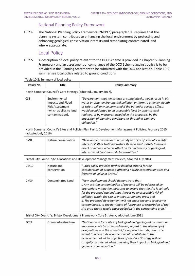
A description of local policy relevant to the DCO Scheme is provided in Chapter 6 Planning Framework and an assessment of compliance of the DCO Scheme against policy is to be provided in the Planning Statement to be submitted with the DCO application. Table 10-2 summarises local policy related to ground conditions.
Table 10-2: Summary of local policy
Policy No. Title Policy Summary
North Somerset Council’s Core Strategy (adopted, January 2017),
CS3 Environmental Impacts and Flood Risk Assessment (which applies to land contamination),
“Development that, on its own or cumulatively, would result in air, water or other environmental pollution or harm to amenity, health or safety will only be permitted if the potential adverse effects would be mitigated to an acceptable level by other control regimes, or by measures included in the proposals, by the imposition of planning conditions or through a planning obligation.“
North Somerset Council’s Sites and Policies Plan Part 1 Development Management Policies, February 2015 (adopted July 2016)
DM8 Nature Conservation “Development within or in proximity to a Site of Special Scientific Interest (SSSI) or National Nature Reserve that is likely to have a direct or indirect adverse affect on its biodiversity or geological interest would not normally be permitted.”
Bristol City Council Site Allocations and Development Management Policies, adopted July 2014
DM19 Nature and conservation
“…this policy provides further detailed criteria for the consideration of proposals affecting nature conservation sites and features of value in Bristol.”
DM34 Contaminated Land “New development should demonstrate that: i. Any existing contamination of the land will be addressed by appropriate mitigation measures to ensure that the site is suitable for the proposed use and that there is no unacceptable risk of pollution within the site or in the surrounding area; and ii. The proposed development will not cause the land to become contaminated, to the detriment of future use or restoration of the site or so that it would cause pollution in the surrounding area.”
Bristol City Council’s, Bristol Development Framework Core Strategy, adopted June 2011
BCS9 Green Infrastructure “National and local sites of biological and geological conservation importance will be protected having regard to the hierarchy of designations and the potential for appropriate mitigation. The extent to which a development would contribute to the achievement of wider objectives of the Core Strategy will be carefully considered when assessing their impact on biological and geological conservation.”
CHAPTER 10 - GEOLOGY, HYDROGEOLOGY, GROUND CONDITIONS, AND CONTAMINATED LAND
PORTISHEAD BRANCH LINE PRELIMINARY ENVIRONMENTAL INFORMATION REPORT, VOLUME 2
10-4
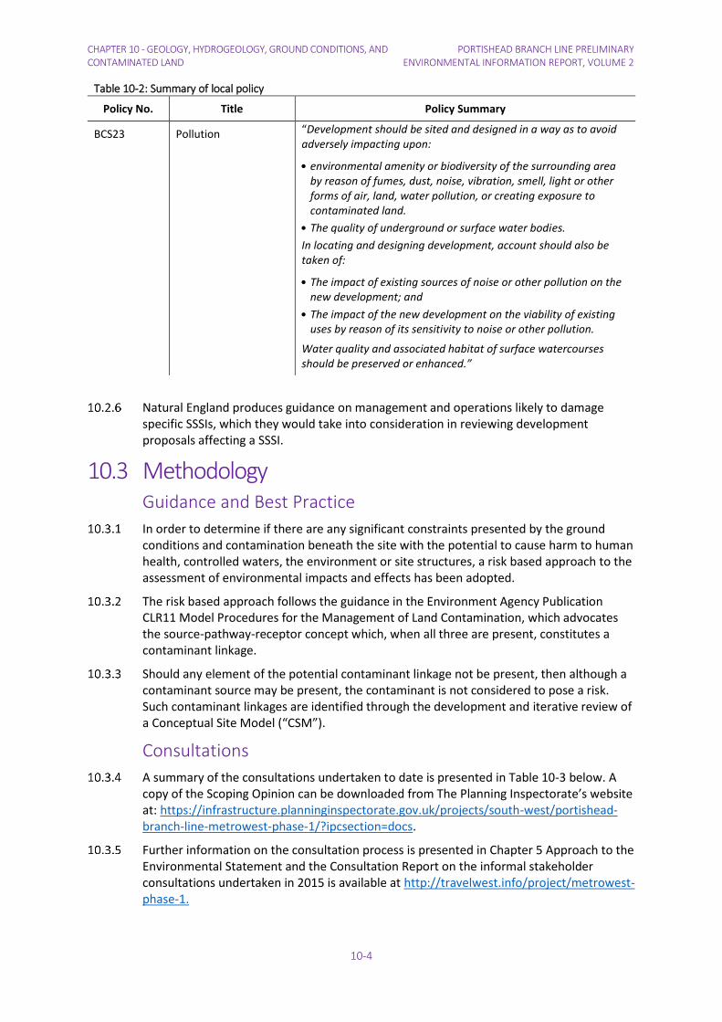
Table 10-2: Summary of local policy
Policy No. Title Policy Summary
BCS23 Pollution “Development should be sited and designed in a way as to avoid adversely impacting upon:
• environmental amenity or biodiversity of the surrounding area by reason of fumes, dust, noise, vibration, smell, light or other forms of air, land, water pollution, or creating exposure to contaminated land.
• The quality of underground or surface water bodies.
In locating and designing development, account should also be taken of:
• The impact of existing sources of noise or other pollution on the new development; and
• The impact of the new development on the viability of existing uses by reason of its sensitivity to noise or other pollution.
Water quality and associated habitat of surface watercourses should be preserved or enhanced.”
Natural England produces guidance on management and operations likely to damage specific SSSIs, which they would take into consideration in reviewing development proposals affecting a SSSI.
10.3 Methodology Guidance and Best Practice
In order to determine if there are any significant constraints presented by the ground conditions and contamination beneath the site with the potential to cause harm to human health, controlled waters, the environment or site structures, a risk based approach to the assessment of environmental impacts and effects has been adopted.
The risk based approach follows the guidance in the Environment Agency Publication CLR11 Model Procedures for the Management of Land Contamination, which advocates the source-pathway-receptor concept which, when all three are present, constitutes a contaminant linkage.
Should any element of the potential contaminant linkage not be present, then although a contaminant source may be present, the contaminant is not considered to pose a risk. Such contaminant linkages are identified through the development and iterative review of a Conceptual Site Model (“CSM”).
Consultations
A summary of the consultations undertaken to date is presented in Table 10-3 below. A copy of the Scoping Opinion can be downloaded from The Planning Inspectorate’s website at: https://infrastructure.planninginspectorate.gov.uk/projects/south-west/portishead-branch-line-metrowest-phase-1/?ipcsection=docs.
Further information on the consultation process is presented in Chapter 5 Approach to the Environmental Statement and the Consultation Report on the informal stakeholder consultations undertaken in 2015 is available at http://travelwest.info/project/metrowest-phase-1.

PORTISHEAD BRANCH LINE PRELIMINARY ENVIRONMENTAL INFORMATION REPORT, VOL. 2
CHAPTER 10 - GEOLOGY, HYDROGEOLOGY, GROUND CONDITIONS, AND CONTAMINATED LAND
10-5
Table 10-3: Summary of consultation responses
Organisation and date Summary of response Consideration within PEI Report
Scoping Opinion Responses (August 2015)
Planning Inspectorate Paragraphs 3.54. The study area needs to be defined sufficiently to include the risk of effects beyond the red line boundary, for example due to the migration of contaminants.
The study area has been designed to include the risk of effects beyond the red line boundary, see paragraph 10.3.6.
Paragraphs 3.55 and 3.56 identify activities which would have impacts on geology, hydrogeology, ground conditions and contaminated land. Paragraph 3.57 states that evidence needs to be provided to justify whether these activities would have an impact on the environment. The Environmental Statement (“ES”) should describe the surveys / investigations undertaken to inform the assessment and support the conclusions.
Activities which may impact ground conditions have been evaluated, see Section 10.3 Methodology and Section 10.6 assessment of effects.
Paragraph 3.8. The ES needs to address the concerns of The Coal Authority regarding any components of the project within the defined coalfield and the Environment Agency regarding the potential for changes in silt to cause pollution of watercourses.
A Coal Authority search was undertaken and mitigation proposed. See paragraphs 10.3.9, 10.4.4 and 10.4.35. The effects of drainage on watercourses is dealt with in Chapter 17 Water Resources, Drainage and Flood Risk.
Paragraph 3.59 states that the widening of Avon Road bridge underpass needs to consider the potential impacts on geology, hydrogeology, ground conditions, and contaminated land.
To be updated once information is available
Paragraph 3.60 states that the ES should describe the methods to assess contamination present in the ballast and the results of this work. The measures proposed to remediate or address contaminants within the site should be discussed and agreed with the relevant consultees (e.g. the Environment Agency) and described in the ES. The potential impacts from implementing any proposed remediation measures should also be assessed.
To be updated once information is available

CHAPTER 10 - GEOLOGY, HYDROGEOLOGY, GROUND CONDITIONS, AND CONTAMINATED LAND PORTISHEAD BRANCH LINE PRELIMINARY ENVIRONMENTAL INFORMATION REPORT, VOLUME 2
10-6
Table 10-3: Summary of consultation responses
Organisation and date Summary of response Consideration within PEI Report
The Coal Authority The proposed works at Ashton Gate Level Crossing and Barons Close Pedestrian Crossing would be located within the defined coalfield and accordingly due consideration should be afforded to ground conditions and the potential for unstable land to be present. The Coal Authority has records of recorded mine entries in the vicinity and likely presence of historic unrecorded underground coal mining at shallow depth. The Authority considers that further consideration of ground investigations should apply to this potential area of coal mining legacy.
The emerging design will now unlikely require further assessment for coal mining risk, see paragraphs 10.4.4 and 10.4.35.
Environment Agency There is potential for contamination of controlled waters due to the mobilisation of historical contamination resulting from historic land uses along the application sites. Prior investigation of the site together with the preparation of an appropriate strategy for the management of contaminated land, would reduce any potential impact on controlled waters.
This is discussed in Section 10.4 baseline and 10.6 assessment of effects.
PORTISHEAD BRANCH LINE PRELIMINARY ENVIRONMENTAL INFORMATION REPORT, VOL. 2
CHAPTER 10 - GEOLOGY, HYDROGEOLOGY, GROUND CONDITIONS, AND CONTAMINATED LAND
10-7
Definition of the Study Area
The study area for the baseline data collection for contaminated land has been based on a 500 m boundary from the railway, which is considered wide enough to capture the risk of horizontal contamination beyond the construction footprint itself and potential impacts on abstraction sources based on professional judgement. The study considers impacts to receptors beyond the DCO Scheme red line boundary, as will any future risk assessments. CIRIA 552, states in Section 4.3.1 – “….it should be recognised that the effects of contamination could be apparent off site; alternatively contamination originating from an off-site source could impact upon the study site. The Phase 1 study should be flexible enough to allow for collection of information beyond the site boundaries as appropriate”).
The Portishead Branch Line DCO Scheme comprises the nationally significant
infrastructure project (“NSIP”) and its associated development. The reconstruction of the
disused section of the railway line between Portishead and Pill falls within the definition of
a nationally significant infrastructure project for the purposes of Section 25 of the Planning
Act 2008, being the construction of a railway over 2 km in length. The other works
required for the DCO Scheme, such as the new stations, works to the highway at
Portishead and the alterations to the railway between Pill and Ashton Junction are
Associated Development as defined by Section 114 of the Planning Act 2008.
Key Receptors
The key receptors are considered to be:
1. Nearby residents, site workers and end users (passengers and staff);
2. Groundwater and surface waters;
3. Geological SSSIs (Ham Green and Avon Gorge); and
4. Buildings and infrastructure (both on and off site).
Defining the Baseline
The following sources of information have been used in determining the likely ground conditions:
1. British Geological Survey online mapping tool;
2. Environment Agency "What's in your backyard" online data warehouse;
3. Coal Authority Interactive Map Viewer;
4. British Geological Survey (“BGS”) Online Lexicon;
5. Landmark EnviroCheck report covering Portishead, the disused section of the railway and parts of Pill;
6. Coal Authority data held on their website;
7. MAGIC online data (www.magic.gov.uk); and
8. Ongoing engineering studies, which include geotechnical, contamination and trackbed investigations.
Assessment of Construction Impacts
The majority of impacts related to ground conditions are during the construction phase. Baseline conditions are examined, and the construction options presented in the GRIP 3 report assessed using the significance criteria below. It should be noted that the majority
CHAPTER 10 - GEOLOGY, HYDROGEOLOGY, GROUND CONDITIONS, AND CONTAMINATED LAND
PORTISHEAD BRANCH LINE PRELIMINARY ENVIRONMENTAL INFORMATION REPORT, VOLUME 2
10-8
of ground conditions impacts are mitigated as part of the DCO Scheme design, for example if contamination is encountered, it is assessed, and if required, remediated as part of the works.
Assessment of Operational Impacts
The operational impacts of the DCO Scheme on Geology, Hydrogeology, Ground Conditions and Contaminated Land have been scoped out. Following construction, there will be no material changes in the underlying soils and geology. While there is a risk of contaminants from the trains discharging onto the track (hydrocarbons and wastewater), any effects on the underlying geology from pollutants entering the ground would be managed through standard maintenance practices. This would be the case for all railways.
Assessment of Decommissioning Impacts
No specific plans have been formulated for the decommissioning phase of the Portishead Branch Line. It is expected that the services will continue for as long as there is a business case for doing so. Closure of railways is a regulated process, overseen by the Office of Rail and Road. Disposal of railway assets is also regulated by the Office of Rail and Road under the terms of Network Rail's licence.
Railways are not designed to be decommissioned, although in accordance with paragraph 5.85 of the NPSNN, development plan policies [and Network Rail's Sustainable Development Strategy], consideration will be given to the sustainability of materials used in construction, including their embodied carbon content, where choice is available and some information on this is provided in Chapter 12 Materials and Waste. For the NSIP, in the event that the train operating company decides to cease services on the Portishead Branch Line, it is likely that the railway assets will remain in place, as occurred after traffic ceased in the 1980s. Previous practice following railway closures suggests that the railway formation will remain available either for re-development over time or finding an alternative transport use such as a guided busway or a cycle path. Such proposals would be subject to their own assessment including consideration of environmental effects. As such proposals are not reasonably foreseeable, the likely impacts cannot be assessed.
For any abandoned part of the railway track bed, vegetation would gradually encroach upon the railway line, with herbaceous plants, shrubs and trees gradually recolonising the railway corridor. The assets comprising the trackbed would gradually fall into disrepair due to the action of erosion and corrosion from rain, plants and animals. As the railway to be authorised by the DCO is largely laid at surface level between Portishead and Pill it is not anticipated that there would be significant need for ongoing maintenance work for embankments or cuttings. Ongoing maintenance of the cuttings and embankments would still be required along the operational railway from the Port to the main line. Network Rail would probably recover (and ideally re-use) items of values such as wiring, signalling equipment and principal supply points (“PSP”).
Remaining assets such as fencing would continue to be maintained. The bridges carrying highways over the DCO Scheme and public rights of way would continue to be maintained to standards appropriate for the public use, as a result of the obligations of North Somerset District Council as local highway authority.
It is anticipated the line between Royal Portbury Dock and Parson Street would remain open for services to the Port. The currently operational railway would remain open for freight traffic even if passenger services ceased and any decision regarding the cessation of freight services would be one for the Freight Operating Companies and Bristol Port Company, so decommissioning the operational railway is not considered relevant or foreseeable for assessing the DCO Scheme. Were any decommissioning of all or part of the

PORTISHEAD BRANCH LINE PRELIMINARY ENVIRONMENTAL INFORMATION REPORT, VOL. 2
CHAPTER 10 - GEOLOGY, HYDROGEOLOGY, GROUND CONDITIONS, AND CONTAMINATED LAND
10-9
operational railway to be proposed in the future, a separate project would be developed, which would be accompanied by a specific assessment of the implications for the Avon Gorge Woodlands Special Area of Conservation
It is not anticipated that the associated development comprising highway works or car parks at Portishead would be altered as a result of the cessation of rail passenger services between Portishead and Bristol. Similarly it is anticipated the car parks at Pill would remain as car parks albeit for all of the car parks development proposals might come forward over time and would be assessed for their planning impacts and any environmental effects at such time as such schemes came forward for the local planning authority to consider. Changes to the UK's use of fuel for transport mean that the nature of emissions from vehicles undertaking any removal of items could only be a matter of speculation.
Assessment of Cumulative Effects
Most ground conditions effects are realised during construction and therefore it is unlikely there will be any significant effects which will cause a cumulative effect.
Use of Significance Criteria
The assessment has followed a two stage approach for defining the environmental impacts and determining the significance of effect relating to Ground Conditions and Contamination. This been undertaken by comparing the Baseline CSM / Preliminary Risk Assessment with the Construction and Operational Phase CSMs and Preliminary Risk Assessments.
The impact assessment includes the remediation measures that would be included to address the potential environmental effects. This CSM comparison approach therefore allows the changes in land contamination status during construction and operation of the proposed development to be identified and clearly identifies the remediation measures required to reduce the level of risk.
For example land that presents a very low contamination risk under baseline site conditions which subsequently becomes a high or very high risk during construction or operation of the proposed development would equate to a ‘Major Adverse Effect’ (or a rise of 4 or 5 risk levels).
The risk level is based on the risk matrix presented in Table 10-4 and the relevant tables and definitions provided in Appendix 10.1 in the PEI Report Volume 4 Appendices.
Table 10-4: Comparison of consequence against probability and related categorisation of risks
Consequence or risk
Pro
bab
ility
of
risk
Severe Medium Mild Minor
High Likelihood Very High Risk High Risk Moderate Risk Moderate/Low Risk
Likely High Risk Moderate Risk Moderate/Low Risk Low Risk
Low Likelihood Moderate Risk Moderate/Low Risk Low Risk Very Low Risk
Unlikely Moderate/Low Risk Low Risk Very Low Risk Very Low Risk
The impact assessment is reported as either beneficial, neutral or adverse effects and
consideration of whether they are major, moderate or minor. Table 10-5 presents an explanation of these criteria.
CHAPTER 10 - GEOLOGY, HYDROGEOLOGY, GROUND CONDITIONS, AND CONTAMINATED LAND
PORTISHEAD BRANCH LINE PRELIMINARY ENVIRONMENTAL INFORMATION REPORT, VOLUME 2
10-10
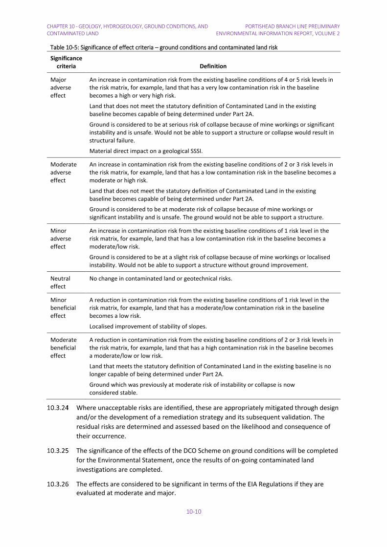
Table 10-5: Significance of effect criteria – ground conditions and contaminated land risk
Significance criteria Definition
Major adverse effect
An increase in contamination risk from the existing baseline conditions of 4 or 5 risk levels in the risk matrix, for example, land that has a very low contamination risk in the baseline becomes a high or very high risk.
Land that does not meet the statutory definition of Contaminated Land in the existing baseline becomes capable of being determined under Part 2A.
Ground is considered to be at serious risk of collapse because of mine workings or significant instability and is unsafe. Would not be able to support a structure or collapse would result in structural failure.
Material direct impact on a geological SSSI.
Moderate adverse effect
An increase in contamination risk from the existing baseline conditions of 2 or 3 risk levels in the risk matrix, for example, land that has a low contamination risk in the baseline becomes a moderate or high risk.
Land that does not meet the statutory definition of Contaminated Land in the existing baseline becomes capable of being determined under Part 2A.
Ground is considered to be at moderate risk of collapse because of mine workings or significant instability and is unsafe. The ground would not be able to support a structure.
Minor adverse effect
An increase in contamination risk from the existing baseline conditions of 1 risk level in the risk matrix, for example, land that has a low contamination risk in the baseline becomes a moderate/low risk.
Ground is considered to be at a slight risk of collapse because of mine workings or localised instability. Would not be able to support a structure without ground improvement.
Neutral effect
No change in contaminated land or geotechnical risks.
Minor beneficial effect
A reduction in contamination risk from the existing baseline conditions of 1 risk level in the risk matrix, for example, land that has a moderate/low contamination risk in the baseline becomes a low risk.
Localised improvement of stability of slopes.
Moderate beneficial effect
A reduction in contamination risk from the existing baseline conditions of 2 or 3 risk levels in the risk matrix, for example, land that has a high contamination risk in the baseline becomes a moderate/low or low risk.
Land that meets the statutory definition of Contaminated Land in the existing baseline is no longer capable of being determined under Part 2A.
Ground which was previously at moderate risk of instability or collapse is now considered stable.
Where unacceptable risks are identified, these are appropriately mitigated through design
and/or the development of a remediation strategy and its subsequent validation. The
residual risks are determined and assessed based on the likelihood and consequence of
their occurrence.
The significance of the effects of the DCO Scheme on ground conditions will be completed
for the Environmental Statement, once the results of on-going contaminated land
investigations are completed.
The effects are considered to be significant in terms of the EIA Regulations if they are evaluated at moderate and major.

PORTISHEAD BRANCH LINE PRELIMINARY ENVIRONMENTAL INFORMATION REPORT, VOL. 2
CHAPTER 10 - GEOLOGY, HYDROGEOLOGY, GROUND CONDITIONS, AND CONTAMINATED LAND
10-11
10.4 Baseline, Future Conditions and Value of Resource Geology
The geological sequence underlying the DCO Scheme is described in Table 10-6.
Table 10-6: The geological sequence underlying the DCO Scheme
Period Strata Description
Triassic Mercia Mudstone Group Dominantly red, less commonly green-grey, mudstones and subordinate siltstones. Thin beds of gypsum/anhydrite widespread; sandstones are also present.
Carboniferous Pennant Sandstone Formation
Green-grey and blue-grey sandstones with thin mudstone/ siltstone and seatearth interbeds and mainly thin coals.
South Wales Middle Coal Measures Formation
Grey coal-bearing mudstones/siltstones, with seatearths and minor sandstones.
Cromhall Sandstone Formation
Brown and red fine- to coarse-grained quartzitic sandstone with subordinate mudstone and limestone.
Oxwich Head Limestone Formation
Thick bedded fine- to coarse-grained, limestones. Units of dark grey, irregularly bedded skeletal packstones with shaly partings are developed at intervals.
Clifton Down Limestone Formation
Mudstones and limestones. Sandy limestone at base in Bristol area.
Goblin Combe Oolite Formation
Massive, medium to coarse grained oolitic limestone with lenses of crinoidal limestone.
Clifton Down Mudstone Formation
Thin- to medium-bedded calcite and dolomite mudstones. A unit of crinoidal and oolitic limestones occurs in the middle of the Formation, and a 15m-thick unit of oolitic and crinoidal limestone occurs in the upper part of Formation.
Gully Oolite Formation Medium- to thick-bedded oolitic grainstone with fine-grained skeletal packstones. Locally in the north Bristol to Tytherington area 6-21m of grey crinoidal limestones, the Sub-Oolite Bed, occurs at the base of the Formation.
Black Rock Limestone Subgroup
Thin to thick-bedded fine to coarse grained packstones with subordinate thin beds of argillaceous packstone and mudstone.
Avon Group Mudstone and Limestone
Interbedded grey mudstones and thin- to medium-bedded skeletal packstones with one to several thick units of ooidal and skeletal grainstones. Thin units of calcite mudstone and mudstone locally present. Sparse thin ironstones.
Avon Group Limestone Interbedded grey mudstones and thin- to medium-bedded skeletal packstones with one to several thick units of ooidal and skeletal grainstones. Thin units of calcite mudstone and mudstone locally present. Sparse thin ironstones.
Shirehampton Formation
Interbedded, thin- to medium-bedded red, green and grey mudstone, limestone, sandstone and siltstone with a thick red crinoidal limestone.
Devonian Portishead Formation Red-green mudstones and marls, red siltstones and red-yellow, hard, fine-grained quartzose sandstones, with conglomerate locally.
Black Nore Sandstone Formation
Sandstones

CHAPTER 10 - GEOLOGY, HYDROGEOLOGY, GROUND CONDITIONS, AND CONTAMINATED LAND
PORTISHEAD BRANCH LINE PRELIMINARY ENVIRONMENTAL INFORMATION REPORT, VOLUME 2
10-12
The Portishead to Pill section of the Portishead Branch Line lies on sediments of the Mercia Mudstone Group for the most part overlain by Tidal Flat Deposits. The Mercia Mudstone Group comprises dominantly red, less commonly green-grey, mudstones and subordinate siltstones with thin beds of gypsum/anhydrite and sandstones also present. Tidal Flat Deposits comprise clay with sand, gravel and peat. There are deposits of artificial ground along the section of the route within Portishead.
The Portbury Freight Line crosses River Terrace Deposits comprising sands and gravels and Head deposits comprising clay, silt, sand and gravel around Pill and crosses an area of alluvial clays and silts associated with a small stream tributary of the River Avon north of Ashton Gate.
The Portbury Freight Line crosses coal bearing strata the surface along the southernmost section around Ashton Gate (which lies within the Red Line Boundary for the Portishead Branch Line). An old coal pit is marked on the 1884 OS map, some 300 m to the west from the railway which survives on mapping editions up to 1955 when the area is developed as allotments. At Ashton Gate the earliest OS map dated 1886 shows Fraynes Colliery as being disused and a colliery associated with the Ashton Vale Ironworks to the north which remains until sometime in the 1940s. Given the long established nature of the railway no impacts are considered from mining.
The Portbury Freight Line passes through a railway cutting at Ham Green (Figure 10-1) which has been designated as a SSSI due to the geological sequence exposed in the cutting. The citation for the SSSI is reproduced below.
"The cutting shows a section through Pleistocene sediments, which include two to three
metres of red-brown, gritty, stony silts, with abundant Greensand chert and other far-
travelled rock-types. These deposits appear to be heavily-cryoturbated terrace gravels or
presumed fluvial origin, although a fluvio-glacial origin has also been suggested. Such
deposits cap a number of flat-topped hills at around 30 metres O.D. A number of Acheulian
handaxes have been found in the area, mostly in the early part of this century. This site is
one of the last good exposures of "high" terrace deposits along the Bristol Avon. This site's
great research potential and its fine exposures make it one of considerable importance."
Ham Green SSSI is also designated for its geological interests as it hosts a complete local succession of the Carboniferous Limestone. The classic work of Vaughan and Reynolds on the marine fossils of the limestones, and the adoption of the sections as the standard for the 'Avonian', makes this one of Britain's historic geological sites, important for both the study and development of stratigraphy. The section spans (with gaps) the entire Tournaisian and Visean series (Courceyan-Brigantian stages), and also includes the Old Red Sandstone Portishead Beds below.
Natural England published their views on the management of this SSSI on line, and this states, “Activities which can cause damage to static geomorphological interest features include developments, coastal protection schemes, removal of material and tree planting. Collecting of geological specimens may also be damaging on some of these sites. A precautionary approach should be adopted before removing or allowing any material to be removed or undertaking any other activity which may cause damage.”
The Portbury Freight Line also passes through the Avon Gorge (shown on Figure 10-1) which is designated as a SSSI primarily for reasons of ecology but part of the citation is reproduced below:
"The Gorge has natural cliffs and quarry exposures of Carboniferous limestone, which are
of great geological interest…"

PORTISHEAD BRANCH LINE PRELIMINARY ENVIRONMENTAL INFORMATION REPORT, VOL. 2
CHAPTER 10 - GEOLOGY, HYDROGEOLOGY, GROUND CONDITIONS, AND CONTAMINATED LAND
10-13
The Avon Gorge affords one of the best opportunities for the study of Carboniferous rocks in Britain, studies which have continued since the early 19th century.
According to Natural England, operations likely to damage the Avon Gorge SSSI include
• Construction, removal or destruction of roads, tracks, walls, fences, hand-stands, banks, ditches or other earthworks, or the laying, maintenance or removal of pipelines and cables, above or below ground
• Clearance of boulders, large stones, loose rock or scree and battering, buttressing or grading rock-faces and cuttings, infilling of pits and quarries.
Two Regionally Important Geological and Geomorphological Site (“RIGS”) have been designated by the locally authorities within 500 m of the DCO Scheme (Figure 10-1). North Somerset Council has designated an area centred on the Ashton Estate as a RIGS which extends eastwards as far as the Rownham Plantation. Bristol City Council has designated part of the Avon Gorge as a RIGS. The DCO Scheme does not cross either designation.
The SSSIs are accorded a high value and the RIGS are accorded a medium value.
Hydrogeology
The Mercia Mudstone is classified as a Secondary B aquifer - predominantly lower permeability layers which may store and yield limited amounts of groundwater due to localised features such as fissures, thin permeable horizons and weathering. These are generally the water-bearing parts of the former non-aquifers.
The Carboniferous sediments are classified as a Principal aquifer; these are layers of rock having high permeability and can provide a high level of water storage. They may support water supply and/or river base flow on a strategic scale.
The Devonian sandstones are classified as Secondary A aquifers; permeable layers capable of supporting water supplies at a local rather than strategic scale, and in some cases forming an important source of base flow to rivers.
The River Terrace Deposits are classified as Secondary A aquifers and are likely to provide limited water resources due to their limited catchment, being isolated over less permeable lithologies.
There are no source protection zones ("SPZ") along or within 2 km of the DCO Scheme.
Land Use History
Historical mapping and environmental regulator information obtained for the disused railway and the potential sources of contamination are summarised on Figure 10-2.
Key potential sources of contamination (starting from Portishead) have been identified as follows:
• A small gasworks, nail factory, paper bag factory, phosphorus factory – all located outside the footprint of the DCO Scheme and since redeveloped, so not considered further.
• A fuel depot, located to the south of the railway and location of Portishead Station (discussed under “Portishead”).
• Power station ash landfill, located to the north of the railway, east of Haven View (discussed under “Portishead”).

CHAPTER 10 - GEOLOGY, HYDROGEOLOGY, GROUND CONDITIONS, AND CONTAMINATED LAND
PORTISHEAD BRANCH LINE PRELIMINARY ENVIRONMENTAL INFORMATION REPORT, VOLUME 2
10-14
• Priory Farm Landfill located between the A369 and the disused railway. The railway forms the northern boundary of the landfill. This is an historical landfill operating in the late 1980s. This is discussed further under “Route Section”.
• Landfills near Ashton Gate (discussed under “Ashton Gate”)
Route Section
The railway corridor was established along its present route in the 1860s, prior to the first edition of the OS map in 1884. The historic maps show that no changes to the railway route have occurred since that time. However, the railway services were stopped, with the line closed to passenger services in 1964 and for freight in 1981. The Portbury Freight Line was re-opened in 2002 to Portbury Dock for freight only.
The Priory Farm Landfill, is located to the south of the railway, bounded to the west by Sheepway Road and to the south by the A369. The Envirocheck report indicates that it may have received inert and non-hazardous wastes (although these may not be consistent with the modern definitions of wastes). The Environment Agency website indicates that the Priory Farm Landfill had leachate and gas controls.
Another landfill, Elm Tree Farm, is located in Sheepway approximately 250 m to the north of the disused railway. Housing is present between the landfill and the railway.
Portishead
Portishead Station was opened in 1867 and demolished in 1954 to make way for the Portishead B Power Station. A new railway station was built where the Waitrose petrol station now stands, but the railway station was closed in 1964 and demolished. The proposed location of the Portishead station is to the east and requires a realignment of Quay’s Avenue with a new Roundabout where it connects at Harbour Road.
The 1884 edition of the OS map shows the railway to the port at Portishead already present and the land between this and the town centre largely undeveloped and low lying. An inlet of the estuary approaches to the north. There is a gas works noted to the north and a nail works to the south as well as the various dock related activities to the north. Between 1931 and 1968 the area was substantially modified with infilling of the inlet and establishment of the road network including Harbour Road to the north. The new development area was used for railway sidings with cranes. By 1974, some of the current commercial buildings along Old Mill Road were established. By 1987, the sidings were gone and the rail connections to the docks were much reduced with further commercial development along Old Mill Road and Harbour Road. Between 1987 and 1999 the last rail connections to the docks were removed and much of the industrial activity in the area ceased. Redevelopment of the area was well established by 2003 and development continued through to 2005 when the current Waitrose building and car park were completed.
The area to the west of Quays Avenue bounded by Wyndham Way to the south, the railway to the north, and a drainage ditch to the west, was marked as a "depot" between 1970 and 1999 on the OS mapping. It is thought that this is the site of a fuel storage depot, which has since been cleared and remediated to make way for redevelopment.
To the east of Quays Avenue, the 1884 OS edition shows the railway as established with the surrounding area divided by field boundaries, which remained unchanged until 1961. The 1968 OS edition shows land raising in cells either side of the drainage ditch, one of which is labelled as a refuse tip. The 1974 OS edition labels these as slag heaps with the 1987 OS edition showing "Tips Disused". Aerial imagery from 2003 shows the current road
PORTISHEAD BRANCH LINE PRELIMINARY ENVIRONMENTAL INFORMATION REPORT, VOL. 2
CHAPTER 10 - GEOLOGY, HYDROGEOLOGY, GROUND CONDITIONS, AND CONTAMINATED LAND
10-15
network being constructed with its completion by 2005 and construction of the residential housing to the north underway.
During a site visit in March 2014, the proposed station site within the railway boundary was observed to be largely overgrown with trees and bushes. The proposed car park area comprises a raised area of grassland along Quays Avenue and Harbour Road. There was no visual evidence of any contamination present. Evidence of a ground investigation was seen within the proposed car park area with three gas monitoring standpipes and a number of trial pits. The made ground at the exposed surface of the trial pits comprised a clay and sand matrix with gravel and cobbles of bricks, sandstone and slag. It is not known who commissioned this ground investigation.
Pill Station
Pill Station was opened in 1867 and closed in 1964. The 1881 OS map shows the railway line in place and a station located within the village. By 1915 Monmouth Road has been built to the north of the railway with housing. Further residential development occurred between 1938 and 1955 continuing until the village reached its current extent sometime between 1970 and 1981. The original station is no longer in use.
The proposed car park to the west of the station is located on former railway sidings / goods yard. These appear on the 1915 OS edition consisting of a single track off the main line with a number of buildings.
The car park site comprises a generally flat area paved with macadam at the entrance and then aggregate. No significant contamination issues have been observed, which will be confirmed by site investigation. The former station area is not accessible from the road above but does not appear to have any significant issues with regards contamination.
Potentially Contaminative Land Uses
The route of the DCO Scheme was an established railway corridor for a considerable period and as such there is potential for the underlying ground to be affected by contaminants associated with railway use such as hydrocarbons and asbestos. The existing ballast along the disused section between Portishead and Pill is no longer suitable and will have to be lifted and replaced with new stone. Some of the ballast is also contaminated and may require treatment, disposal or possibly re-use within the DCO Scheme.
At Portishead the new station will be located on made ground, which may be contaminated due to historic land use. It is unlikely that any contamination would be so significant as to prevent development given the likely structures involved, namely, a station building, platform, car parking and pedestrian and cycle path to the town centre. However, given alterations are required to Quays Avenue, there is more potential to encounter contamination, given the proximity to the former fuel storage depot.
At Pill Station the potential car parking area may be affected by residual contamination associated with use of the site as sidings.
The renovation of the disused railway corridor will require the existing ballast to be lifted and new ballast to be laid, as the existing ballast is no longer physically suitable (railway ballast has to conform to a grading specification). Consideration will be given to whether this ballast can be re-used on site, in non engineering uses, although contamination content of the ballast will need to be assessed. The ballast will also be replaced on the freight line.

CHAPTER 10 - GEOLOGY, HYDROGEOLOGY, GROUND CONDITIONS, AND CONTAMINATED LAND
PORTISHEAD BRANCH LINE PRELIMINARY ENVIRONMENTAL INFORMATION REPORT, VOLUME 2
10-16
Coal Mining and Slope Stability
The proposed works at Ashton Gate Level Crossing and Barons Close Pedestrian Crossing are located within the defined coalfield and accordingly due consideration should be afforded to ground conditions and the potential for unstable land to be present. The Coal Authority has records of recorded mine entries in the vicinity and likely presence of historic unrecorded underground coal mining at shallow depth.
The emerging design will not require the closure of the Ashton Gate Level Crossing. The design consists of extension of the left turn flare lane on Winterstoke Road, optimisation of the Ashton Vale Road signals, and upgrade of signals to ‘MOVA’, and provision of a ramp to the north of the level crossing to connect pedestrians and cyclists from Ashton Vale Road to Ashton Road. With these modifications, the DCO Scheme is unlikely to need further assessment for coal mining risk.
Cliff instability is a known problem within the Avon Gorge, with individual stones and boulders moving downslope to occasional rock falls. On occasions failing stones have struck the freight trains travelling to and fro along this line. Network Rail periodically undertakes “stone picking” exercises to reduce the risk of rock fall. Some of the cliff faces are required to undergo a de-vegetation, inspection and a rock combing exercise to remove all potentially dangerous material.
The following railway embankment slopes will require earthwork solutions for the DCO Scheme (see Figure 4.2) in Volume 3 of the PEI Report. This list is to be confirmed following completion of the GRIP 3 engineering design.
• Pill Station Cutting Down 126 Mi 9.5 Ch to 126 Mi 15.5 Ch (miles and chains)
• Hardwick Road Cutting Down 126 Mi 15.5 Ch to 126 Mi 26 Ch
• Avon Road Embankment Down 126 Mi 27 Ch to 126 Mi 33 Ch
• Avon Road Embankment Up 126 Mi 27 Ch to 126 Mi 33 Ch
10.5 Measures Adopted as Part of the DCO Scheme The ES will identify any measures that have been incorporated as part of the project
description and so have been assessed as part of the Project.
A number of measures have been included as part of the project design in order to minimise certain environmental effects. This includes:
• careful designing of the project to ensure key receptors are avoided where possible;
• construction adopting best practices techniques, which will be set out in Code of Construction Practice ("CoCP") and which is still being finalised and will be submitted with the DCO application, and
• compliance with regulatory and legislative regimes as required by law.
The final ES will fully set out and detail those embedded mitigation measures within each of the topic chapters.

PORTISHEAD BRANCH LINE PRELIMINARY ENVIRONMENTAL INFORMATION REPORT, VOL. 2
CHAPTER 10 - GEOLOGY, HYDROGEOLOGY, GROUND CONDITIONS, AND CONTAMINATED LAND
10-17
10.6 Assessment of Effects Construction Phase
Portishead to Pill
The construction of the new railway along the disused corridor mainly comprises replacement of the ballast, minor modifications to existing earthworks and drainage, and very localised foundations for specific structures. As such construction will have no impact on the underlying geology or hydrogeology in terms of regional and local flows or groundwater quality. There will be no impact on the railway from underlying ground conditions and the railway construction will not be sensitive to any residual contamination beneath the existing railway corridor.
Construction of the station at Portishead may be on land that has residual contamination arising from historic land uses. The nature of the proposed development, being a relatively small station building and platforms, is such that it is not expected that the underlying ground conditions will have a significant impact on the building; any constraints relating to contamination will need to be identified and the construction designed to mitigate the risks identified. The construction itself will have no significant impact on the underlying ground.
The DCO Scheme works in the vicinity of the Priory Farm Landfill consists of ballast replacement and new rails, and clearance/ reformation of ditches. It is not considered that gas and leachate from this landfill, should they be present, is likely to have a significant effect on the DCO Scheme, although gas monitoring during construction should be undertaken.
The Elm Tree Farm Landfill is not considered to present an impact to the railway scheme due to the distance (c250 m) and intervening presence of housing.
The ground conditions at Avon Road Underbridge site and embankment will be investigated as part of the design for the widened structure and changes to the embankment profile.
Renovation of the station at Pill will have no impact on the underlying geology. The station platforms are already in existence and will be replaced. The cutting slope to the south of the station will be designed to form a steeper, stable slope. Construction of the station buildings will need to take account of the ground conditions but it is not anticipated that these would pose any significant constraints on construction.
The construction of the car park will need to take account of the underlying ground conditions, particularly with regard to bearing capacity within the underlying sediments. However it is considered that the existing ground conditions are highly unlikely to be such that construction of a car park would not be possible using standard ground engineering techniques. Any residual contamination present within the old sidings will need to be assessed but again, this is not expected to be so significant that construction of the car park would be affected. Dealing with any such contamination is likely to have a positive effect on the local environment through treatment of any contamination present.
The proposed construction sites at Pill and Portishead stations will be investigated to determine the underlying ground conditions, including ground stability and contamination, in order to inform the design of the proposed structures. These investigations will include assessment of the ground in terms of contaminants that may be present and allow any requirements for mitigation of risks to the development and the
CHAPTER 10 - GEOLOGY, HYDROGEOLOGY, GROUND CONDITIONS, AND CONTAMINATED LAND
PORTISHEAD BRANCH LINE PRELIMINARY ENVIRONMENTAL INFORMATION REPORT, VOLUME 2
10-18
wider environment to be determined. This assessment will be undertaken in accordance with the Model Procedures (Environment Agency, 2004).
Portbury Freight Line (Operational Railway)
The works along the Portbury Freight Line will have no impact on the geology or hydrogeology.
The Ham Green SSSI is unlikely to be affected as the existing rail corridor is wide enough to accommodate the planned services and no excavations of the existing cutting are currently envisaged. Vegetation clearance may allow the cutting to be exposed however the site will be a more active railway and consequently the opportunities for academic study of the exposed sediments will be limited. It will be necessary to site a signal and location case to house telecommunications in the vicinity of Ham Green SSSI, but this should not directly impact on the designated site.
The proposed earthworks along the operating railway line will all be designed to stabilise the slopes and will be contained within the existing railway land. Consequently, these works will be beneficial in terms of slope stability. Within the Avon Gorge, the cliff stabilisation assessment and mitigation measures required are relatively small scale and unlikely to affect significantly the SSSI designation as demonstrated by the on-going periodic phases of rock picking which is undertaken by Network Rail.
The proposed works are not making a significant change to the land use.
Operation Phase
As discussed above, no impacts during operations phase are expected and this topic has been scoped out of further assessment as explained in Section 10.1.
Decommissioning Phase
For the reasons set out at 10.3.11 – 10.3.16 it is not possible to identify realistic options for decommissioning for assessment and no basis on which to consider that there would be reasonably foreseeable significant environmental impacts on ground conditions resulting from decommissioning.
10.7 Mitigation and Residual Effects No likely significant effects have been identified and therefore no further mitigation
measures are proposed. The residual effects remain as described in the preceding sections.
Other mitigation measures are being considered where adverse (but not significant effects in terms of the EIA Regulations) are identified. Proposals are currently being finalised to assess whether they are feasible to include as part of the project. This will be fully documented as part of the ES and there will be ongoing discussions with key stakeholders to consider this further between now and the submission of the DCO application
10.8 Cumulative Effects Other Schemes along the Portishead Branch Line
No cumulative effects with other projects along the Portishead Branch Line are considered likely.

PORTISHEAD BRANCH LINE PRELIMINARY ENVIRONMENTAL INFORMATION REPORT, VOL. 2
CHAPTER 10 - GEOLOGY, HYDROGEOLOGY, GROUND CONDITIONS, AND CONTAMINATED LAND
10-19
Other Works for MetroWest Phase 1
Other elements of MetroWest Phase 1, namely Parson Street Junction and Station Improvements (including works to South Liberty Lane freight depot), Bedminster Down Relief Line, Severn Beach / Avonmouth Signalling and Bathampton Turnback comprise small scale works, confined within the existing railway land. These works are to be undertaken by Network Rail under their permitted development rights and do not form part of the DCO Application.
Network Rail is undertaking an environmental appraisal and action plan, and an environmental risk register for the Parson Street Junction and Station Improvements (including works to South Liberty Lane freight depot), Bedminster Down Relief Line, Severn Beach / Avonmouth Signalling and Bathampton Turnback as part of the reporting for Network Rail’s GRIP process. This process will identify the potential impacts and capture the need for mitigation during design and construction. The results will be carried forward from the present GRIP 3 and 4 phases, into the detailed design phase (GRIP 5) and construction (GRIP 6).
Given the small scale nature of these works and the distances between these projects and the Portishead Branch Line, it is considered that there are no significant cumulative effects during the construction and operation of these projects on ground conditions. Consequently, these works have been scoped out of further cumulative impact assessment for the DCO Scheme.
10.9 Limitations Encountered in Compiling the PEI Report The design of the DCO Scheme, including landscaping is not fully developed. Further risk
assessment may be required once the design is finalised. However, in terms of risks associated with ground conditions, the DCO Scheme is considered unlikely to cause harm to humans or the wider environment, given the guidance in the NPPF.
Supporting information, such as contaminated land risk assessment, geotechnical assessments of mining stability have yet to be completed for elements of the DCO Scheme.
A number of mitigation measures are still being considered as part of the iterative environmental impact assessment. As the PEI Report only demonstrates those environmental effects at a certain point in time pre-application, these will be further refined as the Environmental Statement to be submitted with the DCO application is finalised.
10.10 Summary Table 10-7 sets out the potential construction and operational impacts and effects on the
resources and receptors that have been identified, with an indication of the likely potential mitigation and residual impacts.
Any impacts that may arise from the underlying ground conditions will be dealt with at the construction phase. Such impacts may arise from contaminants within the underlying soils or from the chemical nature of the soils themselves. During the operational life of the DCO Scheme there will be some incidental contamination of the underlying track bed from leaks and spillages; this is not predicted to be significant for the purposes of the EIA Regulations.
The operational impacts on geology, hydrogeology, ground conditions, and contaminated land have been scoped out for the reasons explained in Section 10.1.

PORTISHEAD BRANCH LINE PRELIMINARY ENVIRONMENTAL INFORMATION REPORT, VOL. 2 CHAPTER 10 - GEOLOGY, HYDROGEOLOGY, GROUND CONDITIONS, AND CONTAMINATED LAND
10-20
Table 10-7: Potential Impacts, Mitigation and Residual Impacts of the DCO Scheme on Geology, Hydrogeology, Ground Conditions and Contaminated Land
Aspect of the DCO Scheme Impact Receptors Mitigation Residual Impact
Construction activities
Removal and replacement of ballast along the railway.
Foundations and earthworks at Portishead Station and Avon Road Bridge.
Ballast may require treatment or disposal.
Potential risks to site workers/visitors and groundwater.
Occupants
Building Fabric
Groundwater
Value: high
Risk assessment to determine whether soils require remediation and/or are suitable for reuse. Remediation of soils if required.
Design to remove exposure pathways and/or sources.
Safe handling and final disposal for spoil.
Significance of Effect: Neutral to Minor beneficial Effect
Significance for EIA legislation: Not significant
Operational activities
None.
Cumulative Effects
None.
PORTISHEAD BRANCH LINE PRELIMINARY ENVIRONMENTAL INFORMATION REPORT, VOL. 2
CHAPTER 10 - GEOLOGY, HYDROGEOLOGY, GROUND CONDITIONS, AND CONTAMINATED LAND
10-21
10.11 References Defra, 2006. Circular on Contaminated Land, 01/2006.
Environment Agency, 2004. Model Procedures for the Management of Land Contamination. Publication CLR11.
North Somerset Council, 2015. Sites and Policies Plan Part 1 Development Management Policies.
Office of the Deputy Prime Minster, 2005. Biodiversity and Geological Conservation – Statutory Obligations and their Impact within the Planning System. Government Circular.
10.12 Abbreviations BGS British Geological Society CoCP Code of Construction Practice CSM Conceptual Site Model DCO Development Consent Order EIA Environmental Impact Assessment ES Environmental Statement GRIP Governance for Railway Investment Schemes MOVA Microprocessor Optimised Vehicle Actuation NPPF National Planning Policy Framework NPSNN National Policy Statement for National Networks NSIP Nationally significant infrastructure project ODPM Office of the Deputy Prime Minister OS Ordnance Survey PEI Report Preliminary Environmental Information Report PPE Personal protective equipment PSP Principal supply point (for signalling equipment) RIGS Regionally Important Geological and Geomorphological Sites SPZ Source Protection Zones SSSI Site of Special Scientific Interest

PORTISHEAD BRANCH LINE PRELIMINARY ENVIRONMENTAL INFORMATION REPORT, VOL. 2
CHAPTER 10 - GEOLOGY, HYDROGEOLOGY, GROUND CONDITIONS, AND CONTAMINATED LAND
10-22
This page is intentionally blank.