GEOLOGY AND STRUCTURE OF THE PRECAMBRIAN ROCKS IN
16
International Research Journal of Natural Sciences Vol.1, No. 1, March 2013, pp.14-29 Published by European Centre for Research Training and Development UK (www.ea-journals.org) 14 GEOLOGY AND STRUCTURE OF THE PRECAMBRIAN ROCKS IN IWOROKO, ARE AND AFAO AREA, SOUTHWESTERN NIGERIA. Olusiji Samuel Ayodele Department of Geology, Ekiti State University, P.M.B. 5363. Ado-Ekiti. Abstract: Geologic mapping of the study area revealed three dominant lithologic units namely: banded- gneiss, migmatite-gneiss and granite-gneiss respectively. Systematic structural mapping and study of the area also confirmed the preponderance of different types of folded structures such as ptygmatic, recumbent, disharmonic and asymmetrical folds which trend E-W to NNW-EES. Other structures such as dykes, joints, quartz-veins, fractures and micro faults were also detected on the rocks. The overall results showed that the study area is a manifestation of Precambrian deformation as revealed by the magnitude and style of folding which is an indication of different episodes of deformation on the rocks in the area. Keywords: Iworoko; Are; Afao ; lithologies; Deformation; Structures 1.0 Introduction Nigeria lies to the rest of the West African Craton in the region of late Precambrian to early Paleozoic orogenesis. The Basement complex is made up of Precambrian rocks and these rocks consist of the schist belt infolded in them. The Precambrian rocks in the study area are part of the Precambrian Basement complex of Nigeria which is made up of the migmatite-gneiss complex, the schist belts and the granitoids. The main lithologic units in the study area include; granite-gneiss, migmatite-gneiss and banded-gneiss with well delineated geologic boundaries amongst others. These rocks have undergone polycyclic deformation thereby causing the deformation of both micro and macro structures as displayed on the field. Geologic structures in rocks that can be used as clues in determining the geologic history of an area include fold, fractures, foliation, dyke etc. Some of them are not deformational but are secondary structures developed during metamorphism of after the emplacement of the rocks. Such structure, such as banding shown on the banded-gneiss at the back of the King’s palace in Are Ekiti is a typical example. A lot of work has been done in the study area and similar areas, such work includes, Rahaman (1988), Odeyemi (1977) and Oyawoye (1964), Grant (1978), Anifowose (2006), among others have given account of the geology of this area. Oyawoye (1964), Rahaman (1976), Odeyemi (1977) noted that the rocks in the study area show evidence of polyphase deformation with the plutonic episode of the Pan African event being the most pervasive. Rahaman (1988) noted that the south western basement complex of Nigeria lies within the rest of the Precambrian rocks in Nigeria, he grouped the rocks in this region as migmatite – gneiss complex comprising largely of sedimentary series with associated minor igneous rock intrusions which have been altered by metamorphic, migmatitic and granitic processes. Odeyemi (1999) suggested that almost all the foliation exhibited by rocks of southwestern Nigeria excluding the intrusives are tectonic in origin, because pre-existing primary structures have been obliterated by-subsequent deformation. Anifowose (2004) also noted that joints ranging from minor to major ones are found in all the rock types, some of which are filled with quartz, feldspars or a combination of both which lie generally in the NE-SW direction, while Boesse and ocan (1992) reported that the south western basement complex of Nigeria has been affected by two phases of deformation namely D 1 , D 2 , the first phase (D 1 ) produced tight to isoclinals folds while the second phase (D 2 ) is characterized by more open folds of variable style and large vertical NNE-SSW trending fault. Oluyide (1988), gave evidence that within the basement complex, tectonic deformation has completely obliterated primary structures except in a few places where they survived deformation (Okonkwo, 1992). This study attempts to analyze the various structural elements present on the rocks in the study area, and trying to relate their occurrence to the geology of the area, with the objectives of understanding the structural history of the rocks and the deformational episodes that pervaded them.
Transcript of GEOLOGY AND STRUCTURE OF THE PRECAMBRIAN ROCKS IN

International Research Journal of Natural Sciences
Vol.1, No. 1, March 2013, pp.14-29
Published by European Centre for Research Training and Development UK (www.ea-journals.org)
14
GEOLOGY AND STRUCTURE OF THE PRECAMBRIAN ROCKS IN IWOROKO, ARE AND AFAO AREA, SOUTHWESTERN NIGERIA.
Olusiji Samuel Ayodele
Department of Geology, Ekiti State University, P.M.B. 5363. Ado-Ekiti.
Abstract: Geologic mapping of the study area revealed three dominant lithologic units namely: banded-gneiss, migmatite-gneiss and granite-gneiss respectively. Systematic structural mapping and study of the area also confirmed the preponderance of different types of folded structures such as ptygmatic, recumbent, disharmonic and asymmetrical folds which trend E-W to NNW-EES. Other structures such as dykes, joints, quartz-veins, fractures and micro faults were also detected on the rocks. The overall results showed that the study area is a manifestation of Precambrian deformation as revealed by the magnitude and style of folding which is an indication of different episodes of deformation on the rocks in the area. Keywords: Iworoko; Are; Afao ; lithologies; Deformation; Structures
1.0 Introduction Nigeria lies to the rest of the West African Craton in the region of late Precambrian to early Paleozoic orogenesis. The Basement complex is made up of Precambrian rocks and these rocks consist of the schist belt infolded in them. The Precambrian rocks in the study area are part of the Precambrian Basement complex of Nigeria which is made up of the migmatite-gneiss complex, the schist belts and the granitoids. The main lithologic units in the study area include; granite-gneiss, migmatite-gneiss and banded-gneiss with well delineated geologic boundaries amongst others. These rocks have undergone polycyclic deformation thereby causing the deformation of both micro and macro structures as displayed on the field. Geologic structures in rocks that can be used as clues in determining the geologic history of an area include fold, fractures, foliation, dyke etc. Some of them are not deformational but are secondary structures developed during metamorphism of after the emplacement of the rocks. Such structure, such as banding shown on the banded-gneiss at the back of the King’s palace in Are Ekiti is a typical example. A lot of work has been done in the study area and similar areas, such work includes, Rahaman (1988), Odeyemi (1977) and Oyawoye (1964), Grant (1978), Anifowose (2006), among others have given account of the geology of this area. Oyawoye (1964), Rahaman (1976), Odeyemi (1977) noted that the rocks in the study area show evidence of polyphase deformation with the plutonic episode of the Pan African event being the most pervasive. Rahaman (1988) noted that the south western basement complex of Nigeria lies within the rest of the Precambrian rocks in Nigeria, he grouped the rocks in this region as migmatite – gneiss complex comprising largely of sedimentary series with associated minor igneous rock intrusions which have been altered by metamorphic, migmatitic and granitic processes. Odeyemi (1999) suggested that almost all the foliation exhibited by rocks of southwestern Nigeria excluding the intrusives are tectonic in origin, because pre-existing primary structures have been obliterated by-subsequent deformation. Anifowose (2004) also noted that joints ranging from minor to major ones are found in all the rock types, some of which are filled with quartz, feldspars or a combination of both which lie generally in the NE-SW direction, while Boesse and ocan (1992) reported that the south western basement complex of Nigeria has been affected by two phases of deformation namely D1, D2, the first phase (D1) produced tight to isoclinals folds while the second phase (D2) is characterized by more open folds of variable style and large vertical NNE-SSW trending fault. Oluyide (1988), gave evidence that within the basement complex, tectonic deformation has completely obliterated primary structures except in a few places where they survived deformation (Okonkwo, 1992). This study attempts to analyze the various structural elements present on the rocks in the study area, and trying to relate their occurrence to the geology of the area, with the objectives of understanding the structural history of the rocks and the deformational episodes that pervaded them.

International Research Journal of Natural Sciences
Vol.1, No. 1, March 2013, pp.14-29
Published by European Centre for Research Training and Development UK (www.ea-journals.org)
15
2.0 Location, Accessibility and Human Settlement The study area is one of the major towns in Ifelodun/Irepodun local government in Ekiti state and falls within latitudes 070 41’N – 070 4’N and longitudes 050 15’ E – 050 18’ E respectively, covering an approximate surface area of 242.6km2. The study area is generally accessible and motorable, the availability of both tarred and untarred roads as well as footpaths provide good accessibility to the area and to the outcrops. The settlement pattern in the study area is the nucleated type and the major occupation of the inhabitants are farming and hunting. Topography and Drainage The topography of the area is rugged with undulating terrain with some outcrops in several places. (Fig.1) Most of the rocks in the study area are well exposed and are as high as 240m above sea level in some places especially the outcrop at the back of the King’s palace in Are which is about 243m above the sea level. The drainage system in the area is usually marked with the proliferation of many smaller streams which are dry for many months, especially from Nov – May. There is a major river in the study area called river Oke ode, which flows from the north to the southern part of the area. The drainage pattern typical of the study area is trellis which is controlled by the structures (Fig.2).
Fig. Figure 1: Topographic map of the study area.
Figure 2: The Drainage map of the study area
International Research Journal of Natural Sciences
Vol.1, No. 1, March 2013, pp.14-29
Published by European Centre for Research Training and Development UK (www.ea-journals.org)
16
Geologic Setting of the Study Area The southwestern Nigeria falls between latitude 70N and 100N and longitude 20E and 70E which is made up of rocks which are mainly Precambrian in age. The study area belongs to the Precambrian Basement complex of southwestern Nigeria which lies to the rest of the West African Craton in the region of late Precambrian to early Paleozoic orogenesis. The Nigeria basement complex extends westward and is continuous with the dahomeyan of the Dahomey – Togo - Ghana region to east and the south Mesozoic recent sediments of Dahomey and Niger coastal basins over the basement complex. The west African Craton and the Pan African event, which presents the framework of West Africa in the entire igneous/ metamorphic Structural framework of Africa consist of Precambrian rocks that have been subjected to major supracrustal plutonic events, such as;
� Liberian (3,000 ± 200my) � Eburnean (1,850 ± 250my) � Kibarian (1,150 ± 100my) � Pan African (600my)
The Crystalline rocks which forms the basement complex rocks of Nigeria are exposed in about half the surface area of the country. The remaining half is covered by sedimentary rocks of Sokoto, Chad or Bornu basin, Niger valley, Benue trough and Anambra basin. The Basement rocks are also exposed in the North central, southwestern and eastern part of the country and the basement complex are separated by sedimentary rocks except in the north central where they are interwoven for descriptive purposes. However, the rocks of the Precambrian basement complex of Nigeria have been grouped into four lithologic units by Dada (2006) as follows:
(1) Migmatite-Gneiss-Quartzite Complex; (ii) The schist belts (iii) Pan African Granitoids and; (iv) Unmetamorphosed minor acid and basic rocks
Local Geology of the Study Area Iworoko, Are and Afao Ekiti lies within the basement complex of southwestern Nigeria, and falls within the central part of Ekiti state about 5kms away from the state capital (Ado - Ekiti), and is underlain by migmatite-gneiss complex of Precambrian age. Three main lithologic units were discovered during geologic field mapping of the area which is banded gneiss, migmatite-gneiss and granite-gneiss. The lithological description of these rock units are discussed below. Granite –Gneiss This rock occurs as massive, high rising outcrop in Iworoko and a small portion forming a prominent pluton in Afao. The rock is heterogeneous, consisting of metamorphic and granitic portion with varying textural characteristics. The mineralogy of the outcrop is characterized by felsic minerals such as, quartz, feldspar and mica with some accessory minerals such as Myrmikite. The rock also displayed varieties of structural elements such as folds, cracks, folded quartz-veins and foliations. The granite- granite gneiss in Iworoko has experienced extreme weathering conditions and has undergone several episodes of deformation. Migmatite Gneiss This was found in Are-Ekiti, and trending north - south of the mapped area, it occurs as a small unit in Iworoko in the northwestern part of the mapped area. Most of the mapped migmatite gneiss occurs as low-lying outcrop ranging in textural characteristics from medium to coarse-grained with mafic and felsic bands defined by biotite, hornblende and other ferromagnesian minerals. There was clear evidence of flowing of the materials during metamorphism that affect the country rock and which causes folds and there are also evidence of resistates of the country rock which did not metamorphose in the mapped outcrops in Are Ekiti (Oke-ode). Although, structures like zenoliths were seen on the outcrop, other structural elements include microfolds, dykes, veins and veinlets etc.

International Research Journal of Natural Sciences
Vol.1, No. 1, March 2013, pp.14-29
Published by European Centre for Research Training and Development UK (www.ea-journals.org)
17
Branded Gneiss This is a metamorphic rock dominantly found around Iworoko, trending from the northwest to southwest of Iworoko town. There is also a portion of banded gneiss in migmatite gneiss in Are area. The intensity of metamorphism of the outcrop leads to the alternation and mineralogical alteration of the mafic and felsic minerals in the rock. Also, the texture of the outcrop is medium grained. Structures mapped include foliation, lineation, dyke, folds, Joints and cracks. A pegmatite dyke which cuts discordantly on the banded gneiss was measured to be in 21cm in width behind the king’s palace in Are Ekiti, and the outcrop displays the following strike and dip values. STRIKE 1560 1580 1760 DIP 400E 400E 420E The field relationship of the different lithologies mapped in the study area revealed that the migmatite gneiss is the basement rock followed by Banded-Gneiss and the youngest outcrop is the Granite-Gneiss (Fig.3).
Figure 3: The Geologic and cross-section map of the study area 3.0 Method of Study The method adopted to generate the necessary geological and structural data is based on the geological field mapping operations. This can be divided into two steps. The methods involve; In-situ observation and studying of outcrops and their dispositions, detailed study of the structural features in the rocks such as folds, joints, dyke, foliation etc followed by acquisition of necessary field data during geologic field mapping. This method entails proper observation, identification and systematic description of the rocks, and eventual collection of structural data, noting the disposition, shapes, styles, magnitude, symmetry, trends, axis, plunge, orientation and types of folds and other structural elements. The method of mapping is the grid – controlled type where the basemap is divided into segments and rock samples were taken from each segments on a scale of 1:50,000. Global Positioning System (GPS) was employed in locating accurately the geographical position of outcrops. Seventeen (17) fresh samples were collected from various localities within the study area at one sample per 4km2 (Fig.4).

International Research Journal of Natural Sciences
Vol.1, No. 1, March 2013, pp.14-29
Published by European Centre for Research Training and Development UK (www.ea-journals.org)
18
Figure. 4. Map showing the rock samples collection points. 4.0 Results The field data collected during geologic mapping of the study area are presented in table.1, TABLE.1. FIELD DATA.
S/N Location Longitude Latitude Lithology Texture structure 1 Ori-Oke
Adura 070 43 494́ 050 15 756́ Granite Gneiss Medium to
Fine Grained Cracks, Joints, Dykes, e.t.c.
2 Behind the Iworoko mosque
070 44 018́ 050 15 738́ Granite Gneiss Fine to Medium grain
Veins, Veinlets, Folds e.t.c.
3 Behind Iworoko Grama School
070 43 794́ 050 15 315́ Migmatite Gneiss
Medium to Fine Grain
Quartz Vein, Cracks, Folds, Dykes, Exfoliation
4 Eniafe road 070 44 020́ 050 15 615́ Granite Gneiss Medium to coarse grain
Folds, Veinlets, Quartz veins
5 Off Iworoko Are road
070 44 058́ 050 15 425́ Granite Gneiss Fine to Medium grain
Veins, Dykes.
6 Aba Sunday 070 43 375́ 050 17 114́ Migmatite Gneiss
Medium to coarse grain
Exfoliation, Veinlet, Fold,

International Research Journal of Natural Sciences
Vol.1, No. 1, March 2013, pp.14-29
Published by European Centre for Research Training and Development UK (www.ea-journals.org)
19
Veins 7 Behind
OBA’s Palace
070 43 691́ 050 18 147́ Banded gneiss Medium to coarse grain
Solution hole, Banding, Lineation, Exfoliation
8 Oke Ode 070 42 174́ 050 17 698́ Migmatite Gneiss
Medium to coarse grain
Exfoliation, Lineation, solution hole
9 Oke Isoro 070 42 158́ 050 17 410́ Migmatite Gneiss
Medium to coarse grain
Fold, Dyke, Veins, Xenolith
10 Off Isara road
070 42 410́ 050 18 020́ Migmatite Gneiss
Fine to Medium grain
Fold, Dyke, Veinlets,
11 Isara Are 070 42 310́ 050 17 512́ Migmatite Gneiss
Fine to Medium grain
Solution hole, Fold, Veinlets
12 Afao round about
070 41 647́ 050 19 593́ Granite Gneiss Medium to Coarse grain
Folds, Dyke, Vein, Solution hole
13 Behind Oke iyanu
070 41 578́ 050 19 669́ Granite Gneiss Medium to Coarse grain
Folds, Vein, Cracks, Solution hole
14 Oke Iyanu 070 41 249́ 050 19 405́ Granite Gneiss Coarse to Fine grain
Folds, Fracture, Solution hole
15 Igbimo road 070 43 158́ 050 20 684́ Granite Gneiss Coarse to Fine grain
Vein, Solution hole.
16 Off Igbimo road
070 43 206́ 050 20 409́ Granite Gneiss Fine to coarse grain
Dyke, Vein, Solution hole
17 Elemiya road
070 42 640́ 050 19 680́ Migmatite Gneiss
Medium to fine grain
Dyke, Cracks, Vein.
International Research Journal of Natural Sciences
Vol.1, No. 1, March 2013, pp.14-29
Published by European Centre for Research Training and Development UK (www.ea-journals.org)
20
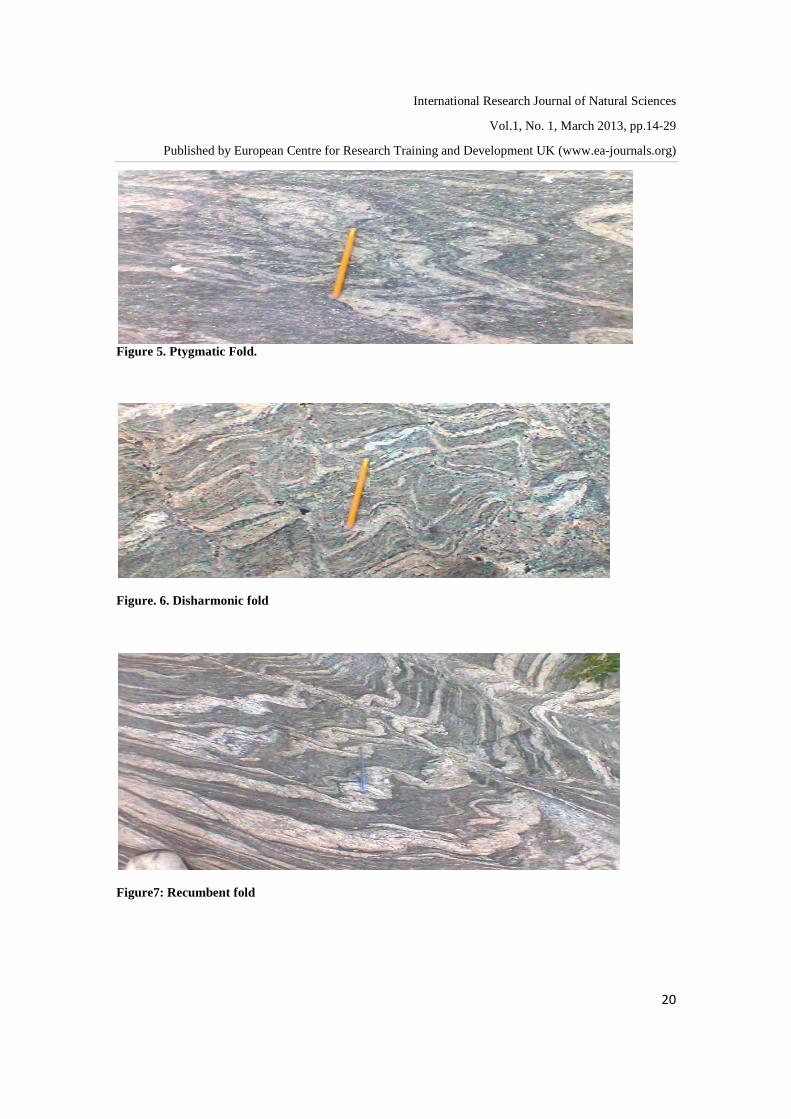
Figure 5. Ptygmatic Fold.
Figure. 6. Disharmonic fold
Figure7: Recumbent fold

International Research Journal of Natural Sciences
Vol.1, No. 1, March 2013, pp.14-29
Published by European Centre for Research Training and Development UK (www.ea-journals.org)
21
Figure8: Asymmetric fold
Figure9: Crenulation fold
Figure10: Quartz-vein

International Research Journal of Natural Sciences
Vol.1, No. 1, March 2013, pp.14-29
Published by European Centre for Research Training and Development UK (www.ea-journals.org)
22
Fig. 11a. Pegmatite Dyke
Fig. 11b. Pegmatite Dyke
Fig.11c. Folded Pegmatite Dyke

International Research Journal of Natural Sciences
Vol.1, No. 1, March 2013, pp.14-29
Published by European Centre for Research Training and Development UK (www.ea-journals.org)
23
Figure 12: Joint
Figure 13a:Foliation
Figure 13b: Foliation
International Research Journal of Natural Sciences
Vol.1, No. 1, March 2013, pp.14-29
Published by European Centre for Research Training and Development UK (www.ea-journals.org)
24
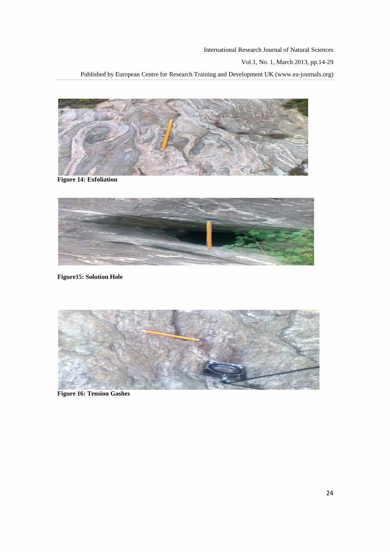
Figure 14: Exfoliation
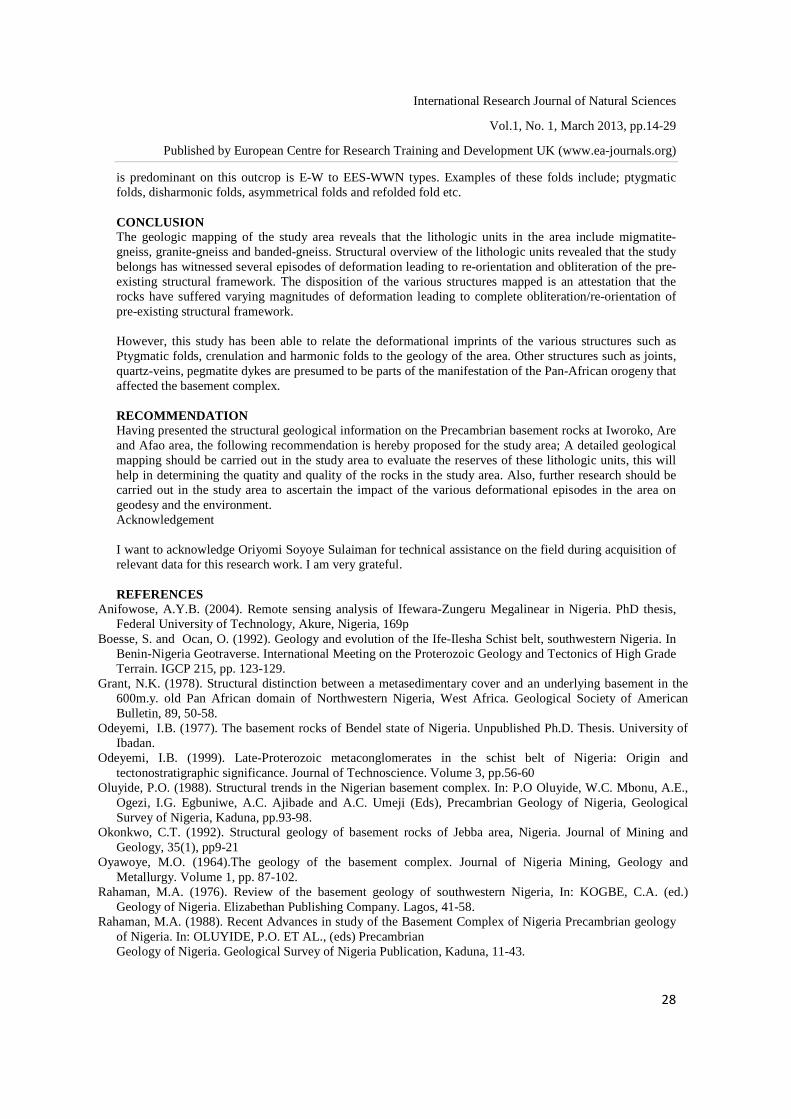
Figure15: Solution Hole
Figure 16: Tension Gashes

International Research Journal of Natural Sciences
Vol.1, No. 1, March 2013, pp.14-29
Published by European Centre for Research Training and Development UK (www.ea-journals.org)
25
Figure17: Xenolith
Figure 18: Cross-cutting relationship between the vein and dyke 5.0 Discussion of Results The study area which is Iworoko, Are and Afao Ekiti are characterized by hilly and undulating rocks. This area is underlain by migmatite-gneiss and granite-gneiss. Therefore, the structural and other geologic data obtained are basically from field studies and observations. The migmatite-gneiss occupies the north- south axis of the study area, forming a prominent pluton. This rock is heterogeneous because it is made up of both the granitic and metamorphic portions with varying textural characteristics. Also, from the field observations and studies, it could be inferred that the migmatite outcrop has been affected by three episodes of deformation denoted as D1, D2, D3. This deformational episode is characterized by varieties, magnitudes and styles of folding recorded in the area. However, the phases of deformation are explained below; The D1 deformation produces tight to isoclinals and asymmetrical folds, with eastern – western vergence. The Second D2, produces ptygmatic and disharmonic folds, this is characterized by steep to moderately inclined axial planes. The Third D3 deformation produces refolded folds which were superimposed on the ptygmatic fold. On the other hand, the granite - gneiss occurs as low lying outcrop in Afao but as a ridge in Iworoko. These rocks are lineated, characterized by the large phenocryst of microcline feldspar. Also, the granite-gneiss in Iworoko behind the Iworoko Secondary school possesses interesting structural features such as cross-cutting veins of different sizes across a major dyke on the outcrop (Fig.18). A pegmatite dyke of about 75cm in width and trending E-W direction was observed on the granite gneiss outcrop, which is made up of quartz, biotite and feldspar (plagioclase and microcline) which is coarser than the intruded rock. This outcrop also displayed various structures like folds, solution hole, veins etc. One other noticeable activity on this outcrop was that it has been partially weathered and so, very difficult to obtain fresh sample for analysis.

International Research Journal of Natural Sciences
Vol.1, No. 1, March 2013, pp.14-29
Published by European Centre for Research Training and Development UK (www.ea-journals.org)
26
However, Banded gneiss occur as a hill in Iworoko Ekiti, and as an intrusive body into the migmatite gneiss in Are. The outcrop served as the peak with elevation of about 240m above the sea level behind the OBA’s Palace in Are. Although, there are evidences of weathering on the outcrop, but not as intense as other outcrops visited in the area, structures were prominent on the outcrop such as banding, foliation and exfoliation (due to physical weathering), dyke, folds and joints and most of these rocks are linearly disposed in north-south direction. ANALYSES OF THE FOLDS AND OTHER STRUCTURES IN THE STUDY AREA When stress is applied on a rock, the competent rocks tend to fold as a result of strain while the incompetent rocks become fractured. The dominant axial trends of the folds are E-W with few trending NNW-SSW direction along the southern segment of the granite-gneiss outcrop. The plunge of one of the folds measured is 250. The prominent folds on the migmatite-gneiss and granite-gneiss in the study area are ptygmatic , disharmonic, crenulation , asymmetrical and recumbent folds. PTYGMATIC AND DISHARMONIC FOLDS These are flow folding defined mineralogically by quartz and feldspar (folded quartzo feldspathic veins). Because of complex nature of the intense deformation on the host rock, they show varying axial trends which could not be identified on some of these folds. However, NNE-SSW, E-W are the axial trends that could be determined. The slope and distances from the hinges and limbs vines (Fig.5). The disharmonic fold (Fig. 6) has no definite orders. Both ptygmatic and disharmonic fold are most common in the study area. RECUMBENT FOLD These are folds with near horizontal or horizontal axial plane. Some of these folds are products of highly ductile deformation with valid axial planes. The recumbent fold identified is found on migmatite-gneiss outcrop at Iworoko. Field studies of this fold revealed that it has been displaced from its original position by earth movements (Fig.7). ASSYMMETRICAL FOLDS This type of fold was observed on the granite-gneiss in Afao. The fold contains a folded quartzo-feldspatic material embedded in it and forming a lineation of quartz minerals. Assymmetric folds are of unequal limbs and the axial planes are not equidistant from the limbs. They show NW-SE and E-W axial trend (Fig.8). CRENULATION FOLD This folded structure was very prominent on the banded-gneiss in Are. They are likely to be formed as a result of two or more stress directions resulting in superimposed foliations as evidenced in (Fig.9). QUARTZ OR QUARTZO-FELDSPARTHIC VEINS These are formed as a result of recrystallization of silicate grains in the rock crevices or joints which are being filled up with hydrothermal fluid which is mainly quartz and feldspar and later solidifying. Some of these veins may be discordant to foliation planes. This structure is mapped on almost all the outcrop visited in the study area (Fig. 10). DYKE Dykes are discordant tabular or sheet-like bodies of magma that cut vertically or almost vertically through and across outcrop. Dykes may occur in swarms of parallel dykes, particularly where there has been crustal extension, fracturing may open the route for filling by magma from a deep source or intrusive magma may promote the fracturing and extension of the crust. The dykes mapped on the area are mostly pegmatitic in nature, mostly of mafic magma containing light minerals (feldspars and quartz). Some of the measured dykes are 42-47cm wide and approximately 2m long, the texture of the pegmatite dyke is coarser than the country rock to which it intruded, and some of the mapped dykes are also folded (figs. 11a, 11b & 11c). JOINTS

International Research Journal of Natural Sciences
Vol.1, No. 1, March 2013, pp.14-29
Published by European Centre for Research Training and Development UK (www.ea-journals.org)
27
The joints mapped on the granite-gneiss behind the king’s palace in Are trend in N-W direction. They are form as a result of tensional strain on an outcrop and they generally occur as sets, with each set consisting of sub-parallel joints to each other. (Fig.12). FOLIATIONS All the rocks mapped in the study area display foliation planes. In the banded-gneiss, the conspicuous surface is marked by parallel layers consisting alternately of dark and light minerals. Also, on the granite-gneiss at Iworoko, two foliation trends were discovered on the outcrop. The first is the east-west trend (E-W). This trend is defined by mineralogical banding and shows consistent dips to the north. This is proven by the limbs of the major fold. The second is the regional trend of foliation in this area which is NNE-SSW (Fig. 13a & 13b). EXFOLIATION This is well pronounced on the migmatite-gneiss at Oke-Ode as well as the granite-gneiss in Iworoko (Fig. 14). It is the gradual peeling of the rock surface due to mechanical weathering as a result of the contraction and expansion of the rocks when heated by the sun. SOLUTION HOLE Solution holes are circular, elongated or spherical holes which are usually found on outcrop where chemical weathering is pronounced. Solution hole are formed when an intruded mineral in the rock body is subjected to differential chemical weathering in which the mineral in contact with a solvent is dissociated into its component ions leaving an hole in the rock. This structure was seen on all the outcrop mapped (Fig. 15). TENSION GASHES Tension gashes are linear openings found on an outcrop which are formed during the deformation as a result of tensional forces developed during deformation. It is filled often by minerals usually quartz and feldspar fillings (Fig.16). XENOLITH Xenoliths are rock fragment within an intrusive igneous body that is unrelated to the igneous body itself. Xenoliths represent pieces of older rock incorporated into the magma while it was still fluid. Also, it could also be as a result of a partial digestion or incomplete digestion of a country rock. This structure was mapped on the migmatite outcrop at Oke- Ode in Iworoko, it has a fine texture compared to the surrounding bodies (Fig. 17) DISCUSSION OF RESULTS The structural analysis of the Precambrian basement rocks in Iworoko, Are and Afao area has been carried out to unravel the type and nature of deformation that has affected these rocks in the geologic past. The structural features common on the rocks in the study area is exhibited on the migmatites which are widespread in the southern part. This is because of the ductile and brittle behavior exhibited by this outcrop due to its heterogeneous nature. The outcrop consists of segregated light coloured granite composition called leucosome within dark coloured materials called melanosome with varying textural characteristics. Although, the migmatite-gneiss is assumed to have been deformed prior to the Pan-African event which causes the upliftment and fracturing of the basement complex, It has also undergone polyclic deformation as indicated by the complexity of the various structural elements present in the rocks (figs. 7-18). The folded structures are pervasive on this outcrop and the foliations in the area are characterized by mineralogical banding which is defined by alternating light and dark minerals. The regional trends of foliations in the migmatite gneiss are predominantly E-W, NNW-EES directions respectively. The various folds displayed are of different magnitudes and styles as exhibited on the rocks. The folds displayed here are of two major sets. The first set is similar folds with small dihedral angles and are tight to isoclinals folds. Both limbs of these folds dip in the same direction and they close sideway with the strike of the axial plane normal to the trend of the fold axis, example are tight folds and isoclinals folds. The second sets are of flow folding are defined mineralogically by quartz and feldspar. The foliation trend that
International Research Journal of Natural Sciences
Vol.1, No. 1, March 2013, pp.14-29
Published by European Centre for Research Training and Development UK (www.ea-journals.org)
28
is predominant on this outcrop is E-W to EES-WWN types. Examples of these folds include; ptygmatic folds, disharmonic folds, asymmetrical folds and refolded fold etc. CONCLUSION The geologic mapping of the study area reveals that the lithologic units in the area include migmatite-gneiss, granite-gneiss and banded-gneiss. Structural overview of the lithologic units revealed that the study belongs has witnessed several episodes of deformation leading to re-orientation and obliteration of the pre-existing structural framework. The disposition of the various structures mapped is an attestation that the rocks have suffered varying magnitudes of deformation leading to complete obliteration/re-orientation of pre-existing structural framework. However, this study has been able to relate the deformational imprints of the various structures such as Ptygmatic folds, crenulation and harmonic folds to the geology of the area. Other structures such as joints, quartz-veins, pegmatite dykes are presumed to be parts of the manifestation of the Pan-African orogeny that affected the basement complex. RECOMMENDATION Having presented the structural geological information on the Precambrian basement rocks at Iworoko, Are and Afao area, the following recommendation is hereby proposed for the study area; A detailed geological mapping should be carried out in the study area to evaluate the reserves of these lithologic units, this will help in determining the quatity and quality of the rocks in the study area. Also, further research should be carried out in the study area to ascertain the impact of the various deformational episodes in the area on geodesy and the environment. Acknowledgement I want to acknowledge Oriyomi Soyoye Sulaiman for technical assistance on the field during acquisition of relevant data for this research work. I am very grateful. REFERENCES
Anifowose, A.Y.B. (2004). Remote sensing analysis of Ifewara-Zungeru Megalinear in Nigeria. PhD thesis, Federal University of Technology, Akure, Nigeria, 169p
Boesse, S. and Ocan, O. (1992). Geology and evolution of the Ife-Ilesha Schist belt, southwestern Nigeria. In Benin-Nigeria Geotraverse. International Meeting on the Proterozoic Geology and Tectonics of High Grade Terrain. IGCP 215, pp. 123-129.
Grant, N.K. (1978). Structural distinction between a metasedimentary cover and an underlying basement in the 600m.y. old Pan African domain of Northwestern Nigeria, West Africa. Geological Society of American Bulletin, 89, 50-58.
Odeyemi, I.B. (1977). The basement rocks of Bendel state of Nigeria. Unpublished Ph.D. Thesis. University of Ibadan.
Odeyemi, I.B. (1999). Late-Proterozoic metaconglomerates in the schist belt of Nigeria: Origin and tectonostratigraphic significance. Journal of Technoscience. Volume 3, pp.56-60
Oluyide, P.O. (1988). Structural trends in the Nigerian basement complex. In: P.O Oluyide, W.C. Mbonu, A.E., Ogezi, I.G. Egbuniwe, A.C. Ajibade and A.C. Umeji (Eds), Precambrian Geology of Nigeria, Geological Survey of Nigeria, Kaduna, pp.93-98.
Okonkwo, C.T. (1992). Structural geology of basement rocks of Jebba area, Nigeria. Journal of Mining and Geology, 35(1), pp9-21
Oyawoye, M.O. (1964).The geology of the basement complex. Journal of Nigeria Mining, Geology and Metallurgy. Volume 1, pp. 87-102.
Rahaman, M.A. (1976). Review of the basement geology of southwestern Nigeria, In: KOGBE, C.A. (ed.) Geology of Nigeria. Elizabethan Publishing Company. Lagos, 41-58.
Rahaman, M.A. (1988). Recent Advances in study of the Basement Complex of Nigeria Precambrian geology of Nigeria. In: OLUYIDE, P.O. ET AL., (eds) Precambrian Geology of Nigeria. Geological Survey of Nigeria Publication, Kaduna, 11-43.

International Research Journal of Natural Sciences
Vol.1, No. 1, March 2013, pp.14-29
Published by European Centre for Research Training and Development UK (www.ea-journals.org)
29
Corresponding authors email: [email protected]; [email protected]