Geology and jungle fieldwork in eastern Indonesia
6
Geology and jungle fieldwork in eastern Indonesia SIMON BAKER, ROBERT HALL & EMILY FORDE Collecting geological information from the jungles and islands of eastern Indonesia depends largely on traditional fieldwork methods involving much footwork and messing about in boats. Coupled with modern laboratoy and coniputinE techniques, information gained on the ground is being used to interpret the tectonic development of east - Indonesia, the Philippine Sea and the western Pacific. to the present day. F o r the geologist, south-east Asia is one of the most intriguing areas of the Earth. The mountains of the Alpine-Himalayan belt make a major bend into Indochina and terminate in a region of continental archipelagos, island arcs and small ocean basins. To the south, west and east the region is surrounded by subduction zones where Pacific and Indian Ocean rocks are currently being subducted at a high rate, accompanied by intense seismicity and spectacular volcanic activity. The abrupt division between Eurasian and Australian flora and fauna in Indonesia, described by Wallace in the nineteenth century, has its origin in the rapid plate movements and reorganization of landmasses in this region. In very general terms, the region owes its origin to the break-up of the Gondwana supercontinent, the subsequent movement of Gondwana fragments northwards, and their eventual collision with Eurasia (Fig. 1). India completed its passage in the Tertiary and col- lided head-on with the Asian landmass. Ac- cording to Tapponnier and colleagues, the impact of the rigid Indian indentor caused extrusion and rotation of continental frag- ments and opening of some of the small oce- anic marginal basins of south-east Asia. Fig. 1.Map illustrating the break-up of Gondwana and the subsequent movement of India and Australia northward from the Mesozoic Fig. 2.Geographic map of east Indonesia and the Philippine Sea region, showing the principal tectonic features; heavy lines with ticks are subduction zones, heavy lines without ticks are major strike- slip faults, stars represent major volcanic centres in active arcs. Top inset shows the study area. Australia separated from Antarctica at about the same time as India but moved less quickly northwards; instead of a direct collision with another continent, Australia is now making a glancing collision with a composite south-east Asia, which already includes some of the ear- lier Gondwana fragments to arrive. In east Indonesia, the area of our field projects, north- wards movement of Australia during the Ter- tiary has been marked by arc-continent colli- sion and major strike-slip motion at the north Australian continental margin. During thc same period the Philippine Sea Plate has been subducting beneath the east Asian margin, 18IGEOLOGY TODAY Januay - February 1994
-
Upload
simon-baker -
Category
Documents
-
view
215 -
download
3
Transcript of Geology and jungle fieldwork in eastern Indonesia

Geology and jungle fieldwork in eastern Indonesia SIMON BAKER, ROBERT HALL & EMILY FORDE
Collecting geological information from the jungles and islands of eastern Indonesia depends largely on traditional fieldwork methods involving much footwork and messing about in boats. Coupled with modern laboratoy and coniputinE techniques, information gained on the ground is being used to interpret the tectonic development of east -
Indonesia, the Philippine Sea and the western Pacific.
to the present day.
F o r the geologist, south-east Asia is one of the most intriguing areas of the Earth. The mountains of the Alpine-Himalayan belt make a major bend into Indochina and terminate in a region of continental archipelagos, island arcs and small ocean basins. To the south, west and east the region is surrounded by subduction zones where Pacific and Indian Ocean rocks are currently being subducted at a high rate, accompanied by intense seismicity and spectacular volcanic activity. The abrupt division between Eurasian and Australian flora and fauna in Indonesia, described by Wallace in the nineteenth century, has its origin in the rapid plate movements and reorganization of landmasses in this region.
In very general terms, the region owes its origin to the break-up of the Gondwana supercontinent, the subsequent movement of Gondwana fragments northwards, and their eventual collision with Eurasia (Fig. 1). India completed its passage in the Tertiary and col- lided head-on with the Asian landmass. Ac- cording to Tapponnier and colleagues, the impact of the rigid Indian indentor caused extrusion and rotation of continental frag- ments and opening of some of the small oce- anic marginal basins of south-east Asia.
Fig. 1.Map illustrating the break-up of Gondwana and the subsequent movement of India and Australia northward from the Mesozoic
Fig. 2.Geographic map of east Indonesia and the Philippine Sea region, showing the principal tectonic features; heavy lines with ticks are subduction zones, heavy lines without ticks are major strike- slip faults, stars represent major volcanic centres in active arcs. Top inset shows the study area.
Australia separated from Antarctica at about the same time as India but moved less quickly northwards; instead of a direct collision with another continent, Australia is now making a glancing collision with a composite south-east Asia, which already includes some of the ear- lier Gondwana fragments to arrive. In east Indonesia, the area of our field projects, north- wards movement of Australia during the Ter- tiary has been marked by arc-continent colli- sion and major strike-slip motion at the north Australian continental margin. During thc same period the Philippine Sea Plate has been subducting beneath the east Asian margin,
18IGEOLOGY TODAY J a n u a y - February 1994

producing a chain of island arcs surrounding the Philippine Sea. The north Australian orogenic belt and the western Pacific arc sys- tems link together in a complex knot in east Indonesia which we have been attempting to unravel during several field expeditions in the last few years (see Fig. 2. for location).
Field operations Our work has been very dependent upon established geological methods. The region was practically unknown from a geological point of view until about 20 years ago; now we probably know about as much as Highland geologists knew of the Scottish mountains 100 years ago. The advantages we have over nineteenth-century geologists are some modern tools such as aerial photographs, satellite images and satellite location devices, but like them we often have relatively poor topographic maps. Laboratory techniques definitely give us an edge when we have collected the rocks: isotopic dating, biostratigraphy, geochemistry, microprobe, palaeomagnetism, gravity and seismic tools are now routine. However, first we have to get our material. Twentieth-century aircraft may get us to east Indonesia quickly, but once there transport is essentially nineteenth century; we move about using small slow boats and on foot.
After obtaining government clearances and meeting our Indonesian colleagues, we fly to the main administrative centre in Halmahera, Ternate. Ternate has long been the major
Fig. 3.View of the Halmahera volcanic arc looking south from Ternate; the islands of Makian, Moti and Mare are just visible in the distance. Tidore displays the classic conical shape often developed by mature arc volcanoes, while the drowned tree in the foreground attests to neotectonic Earth movements. Makian was the site of the last major eruption in the arc in 1988.
Fig. 4.Investigating the west coast of Halmahera by longboat. T h e sheer cliffs are formed from Oligocene volcaniclastic sedimentary rocks of the Tawali Formation and illustrate some of the problems in sampling.
Fig. 5. Lowering skies over the rugged topography of north- east Halmahera indicate a few wet, exhausting days at the site of our next traverse. A low-lying alluvial strip (-5 km wide) terminates abruptly against upfaulted ophiolitic and sedimentary basement rocks that have been deeply incised by the Akelamo River.
centre of power and population in the north Moluccas, along with its adjacent and rival island Tidore. Despite their small size (both are only 10 km in diameter), they have been bitterly fought over by the Spanish, the Portu- guese and later the Dutch and British to con- trol the precious trade in cloves. Ternate town is still a busy port and makes the ideal base for our investigations of the region. For several seasons we have hired a 25-m boat with eight crewmen and stocked it with fuel and provi- sions for a 50-day field expedition. The Sznar Bahtera is a local, general-purpose boat nor- mally used for fishing and transportation; the crew members are mainly young, hard-work- ing and wonderfully friendly. Provisions avail- able without refrigeration are basic: largely rice, noodles, sardines and corned beef along with garlic, tea, coffee, sugar and a few goodies to ward off mutiny amongst the geologists. All
GEOLOGY TODAYJanuay-Februay 1994119

the food is stored in tins or heavy plastic to keep out the damp and the boat's ravenous popula- tion of rats and cockroaches.
Sailing from Ternate harbour is spectacular on a clear morning. Gamalama (Ternate's vol- canic peak) looms 2 km high in the back- ground, the perfect cone of Tidore is to the south and the mountains of central Halmahera rise mistily to the east. On particularly limpid days the active arc can be seen stretching south to Moti and Makian islands (Fig. 3 ) and north into the north-west arm of Halmahera. This arc marks the approximate surface trace of the 1 00-km Benioff zone contour on the eastward subducting Molucca Sea Plate.
Fieldwork has three main objectives: the
Fig. 6.Climbing out of the Tapaya River system in central Halmahera. The density and darkness of the rainforest is well shown here; there are at least five people in this photograph.
Fig. 7.Drilling palaeomagnetic cores in the Cretaceous Gowonli Formation, Gowonli River, E Halmahera. Calc- alkaline debris flows suggest these rocks formed in the forearc of an active arc; palaeomagnetic analysis of these samples indicates -180" of rotation since the Cretaceous.
collection of geological data and rock samples and, especially for plate reconstructions, palaeomagnetic sampling. Coastal gravity sur- veys of the islands have also been completed. Three methods of fieldwork have proved the most efficient ways of covering the ground: coastal investigation by longboat, traverses up rivers on foot accompanied by local guides and, where possible, excursions along logging tracks by jeep or truck.
Coastal work Investigation of coastal exposure provides a good method of rapid coverage of large areas. Exposures are identified whilst sailing along the coast and geologists are sent ashore in the longboat. The longboat is used throughout the islands for short-distance transport and is a highly practical craft despite feeling alarmingly unstable at first. It is made of a hollowed-out tree trunk with the addition of an outboard motor and is an example of Stone Age technology yet to be improved (Fig. 4). The biggest problem encountered with coastal studies is trying to land in heavy swells, and on many occasions the longboat and all aboard have been dumped on a reef or submerged during landing - luckily without injuries. Consequently, tantalizing exposures can go unrecorded except for notes made using binoculars.
The usual routine consists of one or two days examining coastal exposures as we move by boat to the site of the next traverse identified from aerial photographs. Despite the heavy jungle cover, aerial photographic interpreta- tion can be useful in mapping. Ophiolitic and ultrabasic rocks give rise to a high but rounded landscape whose vegetation cover appears rather less luxuriant than other areas. In con- trast, limestones often produce a very distinc- tive, jagged karstic topography that is obvious both from aerial photographs and from off- shore. Quaternary limestones are typically found along the coasts and may achieve eleva- tions above 100 metres, indicating very young uplift along active faults. Fig. 5 shows the rugged basement topography in north-east Halmahera.
River traverses Once at the site of the traverse, a team of two or three geologists, several crew members and up to eight porters from a nearby village will set off up river for several days, taking supplies, fly sheets and bed sleeves. Traverses can vary from pleasant perambulations in cool, ankle- deep water under the high rain-forest canopy to thrashing through vicious rattan thickets on
ZOIGEOLOGY TODAY January - February 1994

steep mountainsides (Fig. 6). Walking through limestone areas can be especially hard going, with many gorges, waterfalls and sink holes to be skirted, often by climbing muddy ravines in a downpour. Heavy rainstorms upstream can often cause rivers to rise suddenly by several metres, making it essential that camps are situated well above high water levels. However, although sudden thunderstorms can fi l l rivers rapidly and halt movement for the day, the flood also subsides quickly and the next morning will normally see a return to sunshine and blue skies.
If suitable, any exposures are drilled for palaeomagnetic cores (Fig. 7). Palaeomagnetic work is dependent on finding suitably mag- netic, well-lithified rocks with good structural control. Particular attention is given to mate- rial that can be dated either by micropalaeontological or isotopic methods. The tropical climate means that many exposures are deeply weathered and time must be spent finding the freshest specimens. However, the heavy rains do have some advantages and, despite thick soils and rotted vegetation cover in the forest, many river sections include excel- lent water-polished outcrops ofvery fresh rock.
Each site is located as precisely as possible on a map or aerial photograph. Existing maps often bear little resemblance to reality in the interior, and position fixing by conventional methods in thick forest can be a nightmare. Enlargements of aerial photos, where avail- able, make good base maps and often allow identification of every bend in steep but sur- prisingly meandering rivers. Recently, hand- held satellite navigation devices have become available and can locate a position to within 20 m ifyou can see enough of the sky through the jungle canopy to find three satellites. By using satellite fixes in conjunction with topographic maps and aerial photos, we are able to locate most positions with a high degree of accuracy.
In the late afternoon, a suitable camp site
Fig. %Home sweet home. The Sinar Bahiera arrives to collect the field team from a traverse.
Fig. 9.Loading a logging truck on the return from a traverse, Woi River, Obi. In wet conditions the rear wheels shower all aboard with huge clods of mud, making the task of hanging on harder still.
next to the river above flood level and away from rotted trees is chosen, the fly sheets and beds are set up, and we then bathe in the river before a supper of rice and sardines. This may be supplemented by river prawns, eel or, occa- sionally, wild pig caught by the porters using dogs and spears. Mornings are cold before the sun rises and it is hard to drag oneself from a warm sleeping bag into damp, muddy field clothes. Geologists and porters alike are kick- started into life by fearsomely strong Indone- sian coffee and the ubiquitous rice and sar- dines.
Wildlife in the jungles of the Halmahera region is relatively benign. Scorpions, some snakes, wild pigs and even crocodiles are the rare dangers, whilst leeches and mosquitoes are unpleasant irritations. However, any trepidations are soon forgotten, for the pri- mary rainforest is a fascinating place. Great fluted trees with buttressed roots rise vertically to the canopy 50-60 m above the ground, lianas loop and dangle from this roof, and strange fruits abound. In many areas the forest floor is relatively clear but in others dense foliage ob- scures everything beyond about 10 m, and it is easy to become separated from the party. Lo- cating them again depends on making loud whooping noises that carry well, and following the answering whoops. Multicoloured parrots and kingfishers are common, streaking across the rivers against the deep green backdrop; colonies of large fruit bats hang in limestone caves whilst the rivers teem with fish, prawns and eels. Swarms of insects at night produce a cacophony of bizarre sounds, and fireflies or luminous mushrooms emit spots of light into
GEOLOGY TODAYJanuay-February 1994121
the gloom. At first, sleeping is difficult in such a strange environment, but this is soon over- come by fatigue and growing familiarity.
Most field work is carried out on the way up- river and the final day usually consists of a forced march downstream, only pausing for lunch or any missed exposure, to the agreed rendezvous with the Sinar Bahtera. After sev- eral days in the forest the boat starts to assume an air of untold luxury and comfort! (Fig. 8)
Road sections There is limited logging in parts of Halmahera and Obi, and in these areas it is often possible to use logging vehicles for excursions along dirt roads (Fig. 9). The nature of the terrain means that logging on a large scale is not possible (and long may it remain so), but some roads provide a way of reaching parts of the interior very rapidly. We have used both jeeps and enormous flat-bed trucks, and the very steep and uneven tracks can mean bone-shaking hours clinging to hot metal. The weather is often wet, and dirt roads swiftly become skid pans, even for the largest trucks. Tracks deteriorate, becoming rapidly overgrown, and wooden bridges rot so that, once disused, roads can be barely passable after a few months. Thus the apparent attractions of high-speed transport to the interior sometimes seem less compelling than several days on wet feet in a river.
Results Once the expedition members and, equally importantly, the rocks are safely home, the many aspects of laboratory work can begin. Isotopic dating is providing a history of island- arc volcanic activity. Trace element and isotopic studies are distinguishing areas underlain by Australian continental crust and Philippine
Mesozoic Late Rleogene
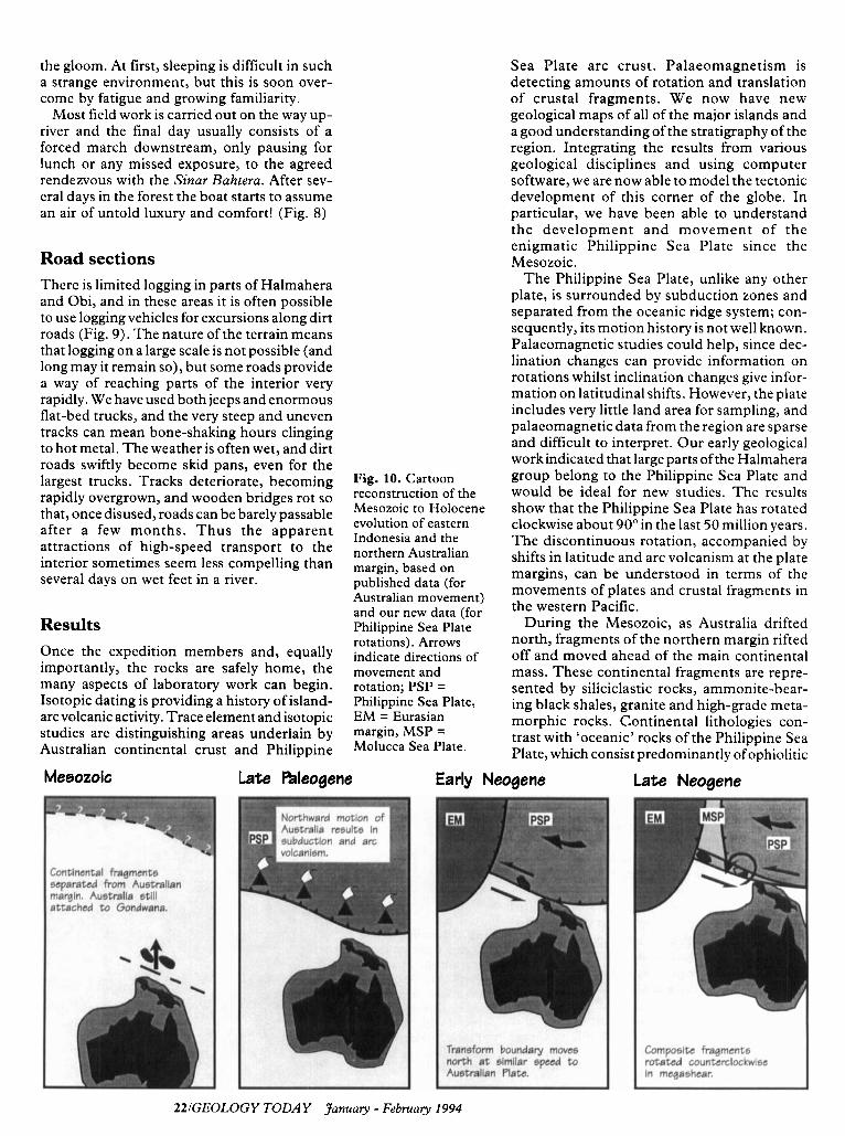
Fig. 10. Cartoon reconstruction of the Mesozoic to Holocene evolution of eastern Indonesia and the northern Australian margin, based on published data (for Australian movement) and our new data (for Philippine Sea Plate rotations). Arrows indicate directions of movement and rotation; PSP = Philippine Sea Plate, EM = Eurasian margin, MSP = Molucca Sea Plate.
Sea Plate arc crust. Palaeomagnetism is detecting amounts of rotation and translation of crustal fragments. We now have new geological maps of all of the major islands and a good understanding of the stratigraphy of the region. Integrating the results from various geological disciplines and using computer software, we are now able to model the tectonic development of this corner of the globe. In particular, we have been able to understand the development and movement of the enigmatic Philippine Sea Plate since the Mesozoic.
The Philippine Sea Plate, unlike any other plate, is surrounded by subduction zones and separated from the oceanic ridge system; con- sequently, its motion history is not well known. Palaeomagnetic studies could help, since dec- lination changes can provide information on rotations whilst inclination changes give infor- mation on latitudinal shifts. However, the plate includes very little land area for sampling, and palaeomagnetic data from the region are sparse and difficult to interpret. Our early geological work indicated that large parts of the Halmahera group belong to the Philippine Sea Plate and would be ideal for new studies. The results show that the Philippine Sea Plate has rotated clockwise about 90" in the last 50 million years. The discontinuous rotation, accompanied by shifts in latitude and arc volcanism at the plate margins, can be understood in terms of the movements of plates and crustal fragments in the western Pacific.
During the Mesozoic, as Australia drifted north, fragments of the northern margin rifted off and moved ahead of the main continental mass. These continental fragments are repre- sented by siliciclastic rocks, ammonite-bear- ing black shales, granite and high-grade meta- morphic rocks. Continental lithologies con- trast with 'oceanic' rocks of the Philippine Sea Plate, which consist predominantly of ophiolitic
Early Neogene Late Neogene
ZZIGEOLOGY TODAY January - Februay 1994

Fig. 11. The crewmen looked after us very well during our stay on the Siiiar Bahtera, and fishing provided a welcome respite from tinned sardines as well as a bit of extra excitement while we sailed from place to place. Ito, Djamire, Soultan and Wallace preparing lunch.
rocks and island-arc sequences (lavas, volcaniclastic conglomerates, sandstones). Arc activity in the southern part of the Philippine Sea Plate was caused by subduction of the Australian plate as it moved north. In the early Neogene, the Australian continental margin collided with the volcanic arc, terminating arc activity and causing the Philippine Sea Plate to begin rotating clockwise. As a result of this rotation, the former subduction boundary de- veloped into a major left-lateral strike-slip sys- tem (the Sorong Fault Zone) which has since moved Australian continental fragments and Philippine Sea crust into the Molucca Sea area. From about 25 million years ago, Philip- pine Sea and Australian fragments have a simi- lar history with, for example, the same regional unconformities and major periods of carbon- ate deposition.
As the Australian and Philippine Sea plates impinged upon the Molucca Sea Plate, the latest episode of arc activity was initiated at around 12 million years as Molucca Sea crust began to be eliminated by subduction at its eastern and western edges, forming the Sangihe and Halmahera arcs (see Fig. 10 for plate reconstruction cartoons). This process is con- tinuing at the present time; the Sorong Fault Zone is taking up clockwise Philippine Sea Plate motion, the Molucca Sea Plate is bent into an inverted U-shape and is nearly elimi- nated, whilst the Philippine Trench is propa- gating south as subduction of the Molucca Sea becomes increasingly unable to accommodate the clockwise movement of the Philippine Sea Plate.
Thus from relatively ‘low tech’, traditional methods of fieldwork we have progressed from the construction of a stratigraphy and geologi- cal maps to a point where we are now able to determine the tectonic environments in which many of the rocks formed and model the evolution of a large area of the western Pacific throughout the Tertiary. This, in turn, has broader implications for the evolution of east- ern Indonesia and the Pacific as a whole. Many scientists and non-scientists have been in- volved in the project and contributed to its success, but special thanks must go to the Indonesian crewmen and village guides with- out whom we would never have been able to negotiate the seas and jungles of the North Moluccas (Fig. 11).
Suggestions for further reading Hall, R. & Nichols, G. J. 1990. Terrane
amalgamation in the Philippine Sea margin, Tectonophysics, v. 18 1, pp. 207-222.
Hall, R., Audley-Charles, M. G., Banner, F. T., Hidayat, S. & Tobing, S. L. 1988. The basement rocks of the Halmahera region, east Indonesia: a Late Cretaceous-Early Tertiary forearc. Journal of the Geological Society of London, v. 145, pp. 65-84.
Hall, R., Nichols, G. J., Ballantyne, P. D., Charlton T. & Ali, J. 199 1. The character and significance of basement rocks of the southern Molucca Sea region. Journal of South-East Asian Earth Science, v. 6, pp. 249- 258.
Katili, J. A., 1980. Geotectonics of Indonesia: A , Modern View. Printed by the Directorate of Mines, Jakarta, Indonesia. 27 lpp.
Katili, J. A. & Reinemund, J. A. 1984. Southeast Asia: Tectonic Framework, Earth Resources and Regional Geological Problems. International Union of Geological Sciences Publication 13, 68pp.
Hamilton, W. B. 1988. Plate tectonics and island arcs. Geological Society of America Bulletin, v. 100, pp. 1503-1527.
Hamilton, W. B. 1979. Tectonics of the Indonesian region. USGS Professional Paper 1078, 345pp.
The Moluccas: The Spice Islands (2nd ed). Muller, K. 1993. Periplus Publications. 200pp.
Indonesia: A Travel Survival Kit . Lonely Planet Publications.
Simon Baker is a research assistant on the Sorong Fault Project, and Robert Hall and Emily Forde are, respectively, Senior Lecturer and research student at University College London.
GEOLOGY TODAYJanuay-February 1994123