Geology 5340 – Lab 5 – Introduction to USDA Soil ... · Web viewMesic.—The mean annual soil...
24
“INTRODUCTION TO USDA SOIL TAXONOMY, SOIL CHARACTERIZATION DATA, AND NRCS WEBSITES” – STEVE DRIESE, BAYLOR UNIVERSITY Rationale: Geologists should learn to use the standard particle size and soil wet-chemical characterization data that are readily available from the National Soils Database maintained by the Natural Resources Conservation Service (NRCS) of the US Department of Agriculture (USDA) to interpret physical, biological, and chemical processes in modern soils. This requires understanding the “foreign language” of soil scientists. There is a wealth of information available at one’s fingertips with the point and click of a mouse. GREAT IDEAS OBJECTIVES: The primary purpose of this presentation is to: (1) introduce you to the nomenclature scheme and hierarchical nature of USDA Soil Taxonomy, (2) introduce you to standard wet-chemical soil characterization analyses, (3) to enable you to use these analyses for soil classification, and (4) show how to use these data for extrapolating to formative properties of soils. These wet chemical soil characterization data are readily accessible from the USDA-NRCS NSSC National Soil Data Access Facility website at: http://soils.usda.gov/survey/nscd/ and there is a newly available national soil geochemical database at: http://soils.usda.gov/survey/geochemistry/index.html . You may also enter queries on official “type” soil series descriptions using the following website: http://soils.usda.gov/technical/classification/osd/index.htm l . Please review the attached field descriptions and soil characterization data for the Tupelo series soil profile sampled on a floodplain in eastern Tennessee. A field photograph of the full soil profile is provided with this presentation, as well as the initial field description. 1
Transcript of Geology 5340 – Lab 5 – Introduction to USDA Soil ... · Web viewMesic.—The mean annual soil...
“INTRODUCTION TO USDA SOIL TAXONOMY, SOIL CHARACTERIZATION DATA, AND NRCS WEBSITES” – STEVE DRIESE,
BAYLOR UNIVERSITY
Rationale: Geologists should learn to use the standard particle size and soil wet-chemical characterization data that are readily available from the National Soils Database maintained by the Natural Resources Conservation Service (NRCS) of the US Department of Agriculture (USDA) to interpret physical, biological, and chemical processes in modern soils. This requires understanding the “foreign language” of soil scientists. There is a wealth of information available at one’s fingertips with the point and click of a mouse.
GREAT IDEAS OBJECTIVES: The primary purpose of this presentation is to: (1) introduce you to the nomenclature scheme and hierarchical nature of USDA Soil Taxonomy, (2) introduce you to standard wet-chemical soil characterization analyses, (3) to enable you to use these analyses for soil classification, and (4) show how to use these data for extrapolating to formative properties of soils. These wet chemical soil characterization data are readily accessible from the USDA-NRCS NSSC National Soil Data Access Facility website at: http://soils.usda.gov/survey/nscd/ and there is a newly available national soil geochemical database at: http://soils.usda.gov/survey/geochemistry/index.html. You may also enter queries on official “type” soil series descriptions using the following website: http://soils.usda.gov/technical/classification/osd/index.html. Please review the attached field descriptions and soil characterization data for the Tupelo series soil profile sampled on a floodplain in eastern Tennessee. A field photograph of the full soil profile is provided with this presentation, as well as the initial field description.
For Soil Characterization Data:
Step 1: Access the USDA-NRCS NSSC National Soil Data Access Facility website at: http://soils.usda.gov/survey/nscd/ and Enter the following to secure access to data for the example: Country: US; State: TN; County: Hamilton 065; Lab Pedon: 02N0445; User Pedon ID: S02TN-065-001; Soil series: sampled as Tupelo. For 2011 Soil Survey Laboratory Information Manual, describing various procedures and methodsdownload: ftp://ftp-fc.sc.egov.usda.gov/NSSC/Lab_Info_Manual/SSIR_45.pdf
Step 2: Click on soil characterization data. Execute Query. Continue. Summary Report. Criteria (huge list of items available, select what you want). Summarize by: Pedon, Horizon master or Horizon Design.
1
For Type Soil Series Description and Mapped Extent:Step 1: Access the USDA-NRCS using the following website: http://soils.usda.gov/technical/classification/osd/index.html.
Step 2: Official Series Description. Soil Series name (enter Tupelo). View Description. Soil Extent.
For USDA Keys to Soil Taxonomy (11th edition 2010) download: ftp://ftp-fc.sc.egov.usda.gov/NSSC/Soil_Taxonomy/keys/2010_Keys_to_Soil_Taxonomy.pdf
2
A horizon
Bt horizon
Btg horizon
Cg horizon
Tupelo Series floodplain site in Hamilton Co., southeastern TN (Driese et al., 2008)
BE horizon
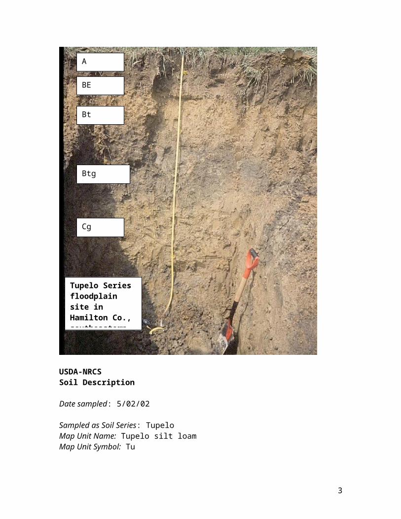
USDA-NRCS Soil Description
Date sampled: 5/02/02
Sampled as Soil Series: TupeloMap Unit Name: Tupelo silt loamMap Unit Symbol: Tu
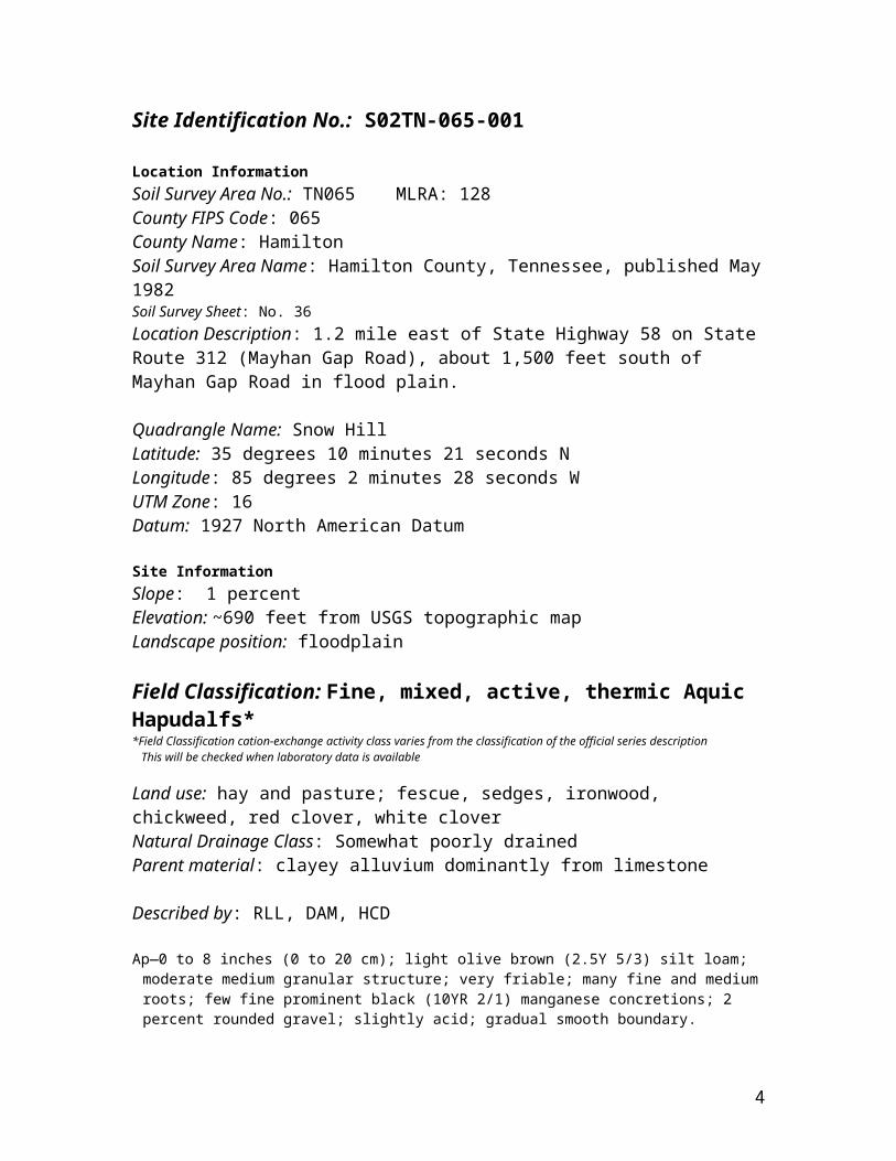
Site Identification No.: S02TN-065-001
Location InformationSoil Survey Area No.: TN065 MLRA: 128County FIPS Code: 065County Name: HamiltonSoil Survey Area Name: Hamilton County, Tennessee, published May 1982Soil Survey Sheet: No. 36Location Description: 1.2 mile east of State Highway 58 on State Route 312 (Mayhan Gap Road), about 1,500 feet south of Mayhan Gap Road in flood plain.
Quadrangle Name: Snow HillLatitude: 35 degrees 10 minutes 21 seconds NLongitude: 85 degrees 2 minutes 28 seconds WUTM Zone: 16 Datum: 1927 North American Datum
Site InformationSlope: 1 percentElevation: ~690 feet from USGS topographic mapLandscape position: floodplain
Field Classification: Fine, mixed, active, thermic Aquic Hapudalfs**Field Classification cation-exchange activity class varies from the classification of the official series description This will be checked when laboratory data is available
Land use: hay and pasture; fescue, sedges, ironwood, chickweed, red clover, white cloverNatural Drainage Class: Somewhat poorly drainedParent material: clayey alluvium dominantly from limestone
Described by: RLL, DAM, HCD
Ap—0 to 8 inches (0 to 20 cm); light olive brown (2.5Y 5/3) silt loam; moderate medium granular structure; very friable; many fine and medium roots; few fine prominent black (10YR 2/1) manganese concretions; 2 percent rounded gravel; slightly acid; gradual smooth boundary.
BE—-8 to 13 inches (20 to 33 cm); dark yellowish brown (2.5Y 5/4) silty clay loam; moderate fine subangular blocky structure; friable; slightly sticky, slightly plastic; many very fine and fine, roots; common medium distinct grayish brown (2.5Y 5/2) iron depletions; common fine prominent yellowish brown (10YR 5/8) masses of iron accumulation; common fine prominent
3
black (10YR 2/1) manganese concretions; 2 percent rounded gravel; slightly acid; clear smooth boundary.
Bt—13 to 29 inches (33 to 74 cm); yellowish brown (10YR 5/6) clay; moderate medium angular and subangular blocky structure; friable; slightly sticky, moderately plastic; few very fine and fine, roots; common distinct clay films on faces of peds; many medium prominent light olive brown (2.5Y 5/4) masses of iron accumulation; common medium prominent grayish brown (2.5Y 5/2) iron depletions; common medium and fine prominent black (10YR 2/1) manganese nodules and concretions; 5 percent rounded gravel; slightly acid; clear wavy boundary.
Btg—29 to 51 inches (74 to 130 cm); olive gray (5Y 5/2) clay; moderate medium angular blocky structure; very firm; very sticky, very plastic; common pressure faces; many prominent clay films on faces of peds; common medium prominent light olive brown (2.5Y 5/4) masses of iron accumulation; common medium prominent black (10YR 2/1) manganese nodules and concretions; 10 percent rounded gravel; slightly acid; clear wavy boundary.
Cg—51 to 80 inches (130 to 203 cm) (sample depth 130 to 183 cm); gray (N 6/) clay; massive; very firm; very sticky, very plastic; many coarse prominent yellowish brown (10YR 5/6) masses of iron accumulation; common fine prominent black (10YR 2/1) manganese concretions; 10 to 15 percent rounded and subrounded gravel; neutral.
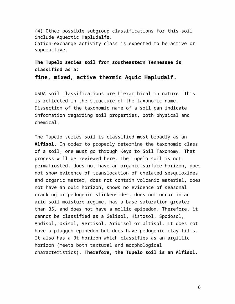
NOTES:(1) Cg horizon—This horizon was sampled to 72 inches (183 cm). The description was extended to 203 cm using an auger. (2) The Cg horizon was not split for sampling.(3) After the pit was sampled, the backhoe deepened the excavation in an attempt to find a bedrock contact. The following observation was made:106 inches (270 cm) --hard dark black to gray thinly laminated limestone that is tentatively identified as the Chickamauga Limestone.(4) Other possible subgroup classifications for this soil include Aquertic Hapludalfs.Cation-exchange activity class is expected to be active or superactive.
The Tupelo series soil from southeastern Tennessee is classified as a:fine, mixed, active thermic Aquic Hapludalf.
USDA soil classifications are hierarchical in nature. This is reflected in the structure of the taxonomic name. Dissection of the taxonomic name of a soil can indicate information regarding soil properties, both physical and chemical.
The Tupelo series soil is classified most broadly as an Alfisol. In order to properly determine the taxonomic class of a soil, one must go through Keys to Soil Taxonomy. That process will be reviewed here. The Tupelo soil is not permafrosted, does not have an organic surface horizon, does not show evidence of translocation of chelated sesquioxides and organic matter, does not contain volcanic material, does not have an oxic horizon, shows no evidence of seasonal cracking or pedogenic slickensides, does not occur in an arid soil moisture regime, has a base saturation greater than 35, and does not have a mollic epipedon. Therefore, it cannot be classified as a Gelisol, Histosol, Spodosol,
4

Andisol, Oxisol, Vertisol, Aridisol or Ultisol. It does not have a plaggen epipedon but does have pedogenic clay films. It also has a Bt horizon which classifies as an argillic horizon (meets both textural and morphological characteristics). Therefore, the Tupelo soil is an Alfisol.
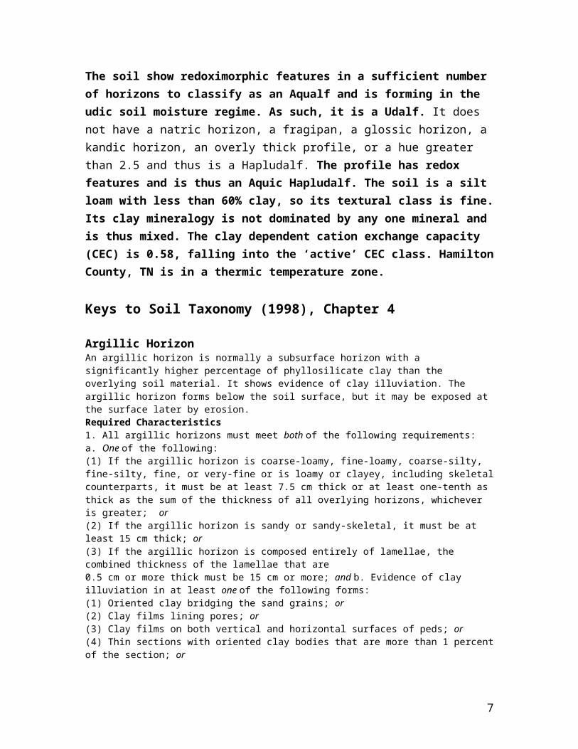
The soil show redoximorphic features in a sufficient number of horizons to classify as an Aqualf and is forming in the udic soil moisture regime. As such, it is a Udalf. It does not have a natric horizon, a fragipan, a glossic horizon, a kandic horizon, an overly thick profile, or a hue greater than 2.5 and thus is a Hapludalf. The profile has redox features and is thus an Aquic Hapludalf. The soil is a silt loam with less than 60% clay, so its textural class is fine. Its clay mineralogy is not dominated by any one mineral and is thus mixed. The clay dependent cation exchange capacity (CEC) is 0.58, falling into the ‘active’ CEC class. Hamilton County, TN is in a thermic temperature zone.
Keys to Soil Taxonomy (1998), Chapter 4
Argillic HorizonAn argillic horizon is normally a subsurface horizon with a significantly higher percentage of phyllosilicate clay than the overlying soil material. It shows evidence of clay illuviation. The argillic horizon forms below the soil surface, but it may be exposed at the surface later by erosion.Required Characteristics1. All argillic horizons must meet both of the following requirements:a. One of the following:(1) If the argillic horizon is coarse-loamy, fine-loamy, coarse-silty, fine-silty, fine, or very-fine or is loamy or clayey, including skeletal counterparts, it must be at least 7.5 cm thick or at least one-tenth as thick as the sum of the thickness of all overlying horizons, whichever is greater; or(2) If the argillic horizon is sandy or sandy-skeletal, it must be at least 15 cm thick; or(3) If the argillic horizon is composed entirely of lamellae, the combined thickness of the lamellae that are0.5 cm or more thick must be 15 cm or more; and b. Evidence of clay illuviation in at least one of the following forms:(1) Oriented clay bridging the sand grains; or(2) Clay films lining pores; or(3) Clay films on both vertical and horizontal surfaces of peds; or(4) Thin sections with oriented clay bodies that are more than 1 percent of the section; or(5) If the coefficient of linear extensibility is 0.04 or higher and the soil has distinct wet and dry seasons, then the ratio of fine clay to total clay in the illuvial horizon is greater by 1.2 times or more than the ratio in the eluvial horizon; and2. If an eluvial horizon remains and there is no lithologic discontinuity between it and the illuvial horizon and no plow layer directly above the illuvial layer, then the illuvial horizon must contain more total clay than the eluvial horizon within a vertical distance of 30 cm or less, as follows:a. If any part of the eluvial horizon has less than 15 percent total clay in the fine-earth fraction, the argillic horizon must contain at least 3 percent (absolute) more clay (10 percent versus 13 percent, for example); orb. If the eluvial horizon has 15 to 40 percent total clay in the fine-earth fraction, the argillic horizon must have at least 1.2 times more clay than the eluvial horizon; orc. If the eluvial horizon has 40 percent or more total clay in the fine-earth fraction, the argillic horizon must contain at least 8 percent (absolute) more clay (42 percent versus 50 percent, for example).
5
Horizons and Characteristics Diagnostic for Both Mineral andOrganic SoilsFollowing are descriptions of the horizons and characteristics that are diagnostic for both mineral and organic soils.
Aquic Conditions2
Soils with aquic (L. aqua, water) conditions are those that currently undergo continuous or periodic saturation and reduction. The presence of these conditions is indicated by redoximorphic features, except in Histosols and Histels, and can be verified by measuring saturation and reduction, except in artificially drained soils. Artificial drainage is defined here as the removal of free water from soils having aquic conditions by surface mounding, ditches, or subsurface tiles to the extent that water table levels are changed significantly in connection with specific types of land use. In the keys, artificially drained soils are included with soils that have aquic conditions. Elements of aquic conditions are as follows:1. Saturation is characterized by zero or positive pressure in the soil water and can generally be determined by observing free water in an unlined auger hole. Problems may arise, however, in clayey soils with peds, where an unlined auger hole may fill with water flowing along faces of peds while the soil matrix is and remains unsaturated (bypass flow). Such free water may incorrectly suggest the presence of a water table, while the actual water table occurs at greater depth. Use of well sealed piezometers or tensiometers is therefore recommended for measuring saturation. Problems may still occur, however, if water runs into piezometer slits near the bottom of the piezometer hole or if tensiometers with slowly reacting manometers are used. The first problem can be overcome by using piezometers with smaller slits and the second by using transducer tensiometry, which reacts faster than manometers. Soils are considered wet if they have pressure heads greater than -1 kPa. Only macropores, such as cracks between peds or channels, are then filled with air, while the soil matrix is usually still saturated. Obviously, exact measurements of the wet state can be obtained only with tensiometers. For operational purposes, the use of piezometers is recommended as a standard method. The duration of saturation required for creating aquic conditions varies, depending on the soil environment, and is not specified. Three types of saturation are defined:a. Endosaturation.—The soil is saturated with water in all layers from the upper boundary of saturation to a depth of 200 cm or more from the mineral soil surface.b. Episaturation.—The soil is saturated with water in one or more layers within 200 cm of the mineral soil surface and also has one or more unsaturated layers, with an upper boundary above a depth of 200 cm, below the saturated layer. The zone of saturation, i.e., the water table, is perched on top of a relatively impermeable layer.c. Anthric saturation.—This term refers to a special kind of aquic conditions that occur in soils that are cultivated and irrigated (flood irrigation). Soils with anthraquic conditions must meet the requirements for aquic conditions and in addition have both of the following:
(1) A tilled surface layer and a directly underlying slowly permeable layer that has, for 3 months or more in normal years, both:(a) Saturation and reduction; and(b) Chroma of 2 or less in the matrix; and(2) A subsurface horizon with one or more of the following:(a) Redox depletions with a color value, moist, of 4 or more and chroma of 2 or less in macropores; or(b) Redox concentrations of iron; or(c) 2 times or more the amount of iron (by dithionite citrate) contained in the tilled surface layer.
2. The degree of reduction in a soil can be characterized by the direct measurement of redox potentials. Direct measurements should take into account chemical equilibria as expressed by stability diagrams in standard soil textbooks. Reduction and oxidation processes are also a function of soil pH. Obtaining accurate measurements of the degree of reduction in a soil is difficult. In the context of this taxonomy, however, only a degree of reduction that results in reduced iron is considered, because it produces the
6
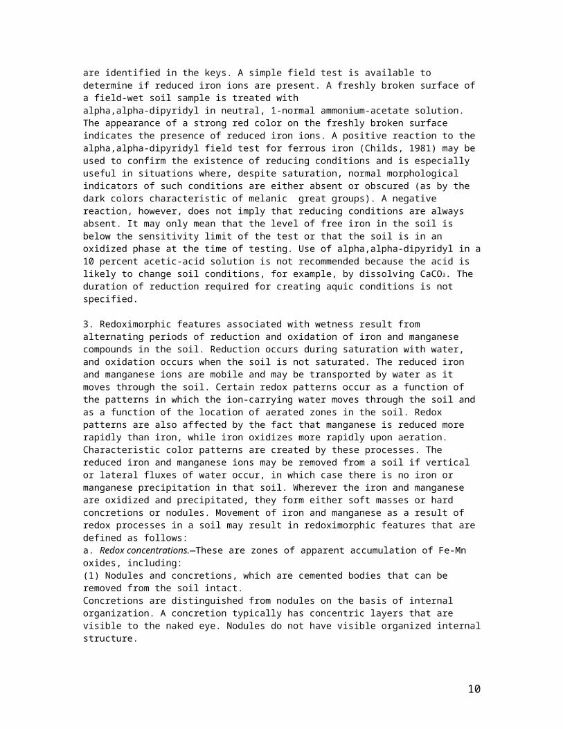
visible redoximorphic features that are identified in the keys. A simple field test is available to determine if reduced iron ions are present. A freshly broken surface of a field-wet soil sample is treated withalpha,alpha-dipyridyl in neutral, 1-normal ammonium-acetate solution. The appearance of a strong red color on the freshly broken surface indicates the presence of reduced iron ions. A positive reaction to the alpha,alpha-dipyridyl field test for ferrous iron (Childs, 1981) may be used to confirm the existence of reducing conditions and is especially useful in situations where, despite saturation, normal morphological indicators of such conditions are either absent or obscured (as by the dark colors characteristic of melanic great groups). A negative reaction, however, does not imply that reducing conditions are always absent. It may only mean that the level of free iron in the soil is below the sensitivity limit of the test or that the soil is in an oxidized phase at the time of testing. Use of alpha,alpha-dipyridyl in a 10 percent acetic-acid solution is not recommended because the acid is likely to change soil conditions, for example, by dissolving CaCO3. The duration of reduction required for creating aquic conditions is not specified.
3. Redoximorphic features associated with wetness result from alternating periods of reduction and oxidation of iron and manganese compounds in the soil. Reduction occurs during saturation with water, and oxidation occurs when the soil is not saturated. The reduced iron and manganese ions are mobile and may be transported by water as it moves through the soil. Certain redox patterns occur as a function of the patterns in which the ion-carrying water moves through the soil and as a function of the location of aerated zones in the soil. Redox patterns are also affected by the fact that manganese is reduced more rapidly than iron, while iron oxidizes more rapidly upon aeration. Characteristic color patterns are created by these processes. The reduced iron and manganese ions may be removed from a soil if vertical or lateral fluxes of water occur, in which case there is no iron or manganese precipitation in that soil. Wherever the iron and manganese are oxidized and precipitated, they form either soft masses or hard concretions or nodules. Movement of iron and manganese as a result of redox processes in a soil may result in redoximorphic features that are defined as follows:a. Redox concentrations.—These are zones of apparent accumulation of Fe-Mn oxides, including:(1) Nodules and concretions, which are cemented bodies that can be removed from the soil intact.Concretions are distinguished from nodules on the basis of internal organization. A concretion typically has concentric layers that are visible to the naked eye. Nodules do not have visible organized internal structure.Boundaries commonly are diffuse if formed in situ and sharp after pedoturbation. Sharp boundaries may be relict features in some soils; and(2) Masses, which are noncemented concentrations of substances within the soil matrix; and(3) Pore linings, i.e., zones of accumulation along pores that may be either coatings on pore surfaces or impregnations from the matrix adjacent to the pores.b. Redox depletions.—These are zones of low chroma (chromas less than those in the matrix) where either Fe-Mn oxides alone or both Fe-Mn oxides and clay have been stripped out, including:(1) Iron depletions, i.e., zones that contain low amounts of Fe and Mn oxides but have a clay content similar to that of the adjacent matrix (often referred to as albans or neoalbans); and(2) Clay depletions, i.e., zones that contain low amounts of Fe, Mn, and clay (often referred to as silt coatings or skeletans).c. Reduced matrix.—This is a soil matrix that has low chroma in situ but undergoes a change in hue or chroma within 30 minutes after the soil material has been exposed to air.d. In soils that have no visible redoximorphic features, a reaction to an alpha,alpha-dipyridyl solution satisfies the requirement for redoximorphic features. Field experience indicates that it is not possible to define a specific set of redoximorphic features that is uniquely characteristic of all of the taxa in one particular category. Therefore, color patterns that are unique to specific taxa are referenced in the keys.Anthraquic conditions are a variant of episaturation and are associated with controlled flooding (for such crops as wetland rice and cranberries), which causes reduction processes in the saturated, puddled surface soil and oxidation of reduced and mobilized iron and manganese in the unsaturated subsoil.
2 In 1992, the term “aquic conditions” was introduced and other changes were made throughout this taxonomy as a result of recommendations submitted to NRCS by the International Committee on Aquic Moisture Regime (ICOMAQ), which was established in 1982 and was chaired initially by Dr. Frank Moormann, then by Dr. Johan Bouma.
Soil Moisture Regimes
7

The term “soil moisture regime” refers to the presence or absence either of ground water or of water held at a tension of less than 1500 kPa in the soil or in specific horizons during periods of the year. Water held at a tension of 1500 kPa or more is not available to keep most mesophytic plants alive. The availability of water is also affected by dissolved salts. If a soil is saturated with water that is too salty to be available to most plants, it is considered salty rather than dry. Consequently, a horizon is considered dry when the moisture tension is 1500 kPa or more and is considered moist if water is held at a tension of less than 1500 kPa but more than zero. A soil may be continuously moist in some or all horizons either throughout the year or for some part of the year. It may be either moist in winter, and dry in summer, or the reverse. In the NorthernHemisphere, summer refers to June, July, and August and winter refers to December, January, and February.Classes of Soil Moisture RegimesThe soil moisture regimes are defined in terms of the level of ground water and in terms of the seasonal presence or absence of water held at a tension of less than 1500 kPa in the moisture control section. It is assumed in the definitions that the soil supports whatever vegetation it is capable of supporting, i.e., crops, grass, or native vegetation, and that the amount of stored moisture is not being increased by irrigation or fallowing. These cultural practices affect the soil moisture conditions as long as they are continued.Aquic moisture regime.—The aquic (L. aqua, water) moisture regime is a reducing regime in a soil that is virtually free of dissolved oxygen because it is saturated by water. Some soils are saturated with water at times while dissolved oxygen is present, either because the water is moving or because the environment is unfavorable for micro-organisms (e.g., if the temperature is less than 1oC); such a regime is not consideredaquic. It is not known how long a soil must be saturated before it is said to have an aquic moisture regime, but the duration must be at least a few days, because it is implicit in the concept that dissolved oxygen is virtually absent. Because dissolved oxygen is removed from ground water by respiration of microorganisms, roots, and soil fauna, it is also implicit in the concept that the soil temperature is above biologic zero for some time while the soil is saturated. Biologic zero is defined as 5oC in this taxonomy. In some of the very cold regions of the world, however, biological activity occurs at temperatures below 5oC.Very commonly, the level of ground water fluctuates with the seasons; it is highest in the rainy season or in fall, winter, or spring if cold weather virtually stops evapotranspiration. There are soils, however, in which the ground water is always at or very close to the surface. Examples are soils in tidal marshes or in closed, landlocked depressions fed by perennial streams. Such soils are considered to have a peraquic moisture regime
Udic moisture regime.—The udic (L. udus, humid) moisture regime is one in which the soil moisture control section is not dry in any part for as long as 90 cumulative days in normal years. If the mean annual soil temperature is lower than 22 oC and if the mean winter and mean summer soil temperatures at a depth of 50 cm from the soil surface differ by 6 oC or more, the soil moisture control section, in normal years, is dry in all parts for less than 45 consecutive days in the 4 months following the summer solstice. In addition, the udic moisture regime requires, except for short periods, a threephase system, solid-liquid-gas, in part or all of the soil moisture control section when the soil temperature is above 5oC. The udic moisture regime is common to the soils of humid climates that have well distributed rainfall; have enough rain in summer so that the amount of stored moisture plus rainfall is approximately equal to, or exceeds, the amount of evapotranspiration; or have adequate winter rains to recharge the soils and cool, foggy summers, as in coastal areas. Water moves downward through the soils at some time in normal years. In climates where precipitation exceeds evapotranspiration in all months of normal years, the moisture tension rarely reaches 100 kPa in the soil moisture control section, although there are occasional brief periods when some stored moisture is used. The water moves through the soil in all months when it is not frozen. Such an extremely wet moisture regime is called perudic (L. per, throughout in time, and L. udus, humid). In the names of most taxa, the formative element “ud” is used to indicate either a udic or a perudic regime; the formative element “per” is used in selected taxa.
Ustic moisture regime.—The ustic (L. ustus, burnt; implying dryness) moisture regime is intermediate between the aridic regime and the udic regime. Its concept is one of moisture that is limited but is present at a time when conditions are suitable for plant growth. The concept of the ustic moisture regime is not applied to soils that have permafrost or a cryic soil temperature regime (defined below). If the mean annual soil temperature is 22oC or higher or if the mean summer and winter soil temperatures differ by less than 6oC at a depth of 50 cm below the soil surface, the soil moisture control section in areas of the ustic
8

moisture regime is dry in some or all parts for 90 or more cumulative days in normal years. It is moist, however, in some part either for more than 180 cumulative days per year or for 90 or more consecutive days. If the mean annual soil temperature is lower than 22oC and if the mean summer and winter soil temperatures differ by 6oC or more at a depth of 50 cm from the soil surface, the soil moisture control section in areas of the ustic moisture regime is dry in some or all parts for 90 or more cumulative days in normal years, but it is not dry in all parts for more than half of the cumulative days when the soil temperature at a depth of 50 cm is higher than 5oC. If in normal years the moisture control section is moist in all parts for 45 or more consecutive days in the 4 months following the winter solstice, the moisture control section is dry in all parts for less than 45 consecutive days in the 4 months following the summer solstice. In tropical and subtropical regions that have a monsoon climate with either one or two dry seasons, ummer and winter seasons have little meaning. In those regions the moisture regime is ustic if there is at least one rainy season of 3 months or more. In temperate regions of subhumid or semiarid climates, the rainy seasons are usually spring and summer or spring and fall, but never winter. Native plants are mostly annuals or plants that have a dormant period while the soil is dry.
Soil Temperature Regimes
Mesic.—The mean annual soil temperature is 8oC or higher but lower than 15oC, and the difference between mean summer and mean winter soil temperatures is more than 6oC either at a depth of 50 cm from the soil surface or at a densic, lithic, or paralithic contact, whichever is shallower.
Thermic.—The mean annual soil temperature is 15oC or higher but lower than 22oC, and the difference between mean summer and mean winter soil temperatures is more than 6oC either at a depth of 50 cm from the soil surface or at a densic, lithic, or paralithic contact, whichever is shallower.
Hyperthermic.—The mean annual soil temperature is 22oC or higher, and the difference between mean summer and mean winter soil temperatures is more than 6oC either at a depth of 50 cm from the soil surface or at a densic, lithic, or paralithic contact, whichever is shallower. If the name of a soil temperature regime has the prefix iso, the mean summer and mean winter soil temperatures differ by less than 6oC at a depth of 50 cm or at a densic, lithic, or paralithic contact, whichever is shallower.
Keys to Soil Taxonomy (1998), Chapter 5AlfisolsKey to SubordersJA. Alfisols that have, in one or more horizons within 50 cm of the mineral soil surface, aquic conditions (other than anthraquic conditions) for some time in normal years (or artificial drainage) and have one or both of the following:1. Redoximorphic features in all layers between either the lower boundary of an Ap horizon or a depth of 25 cm below the mineral soil surface, whichever is deeper, and a depth of 40 cm; and one of the following within the upper 12.5 cm of the argillic, natric, glossic, or kandic horizon:a. 50 percent or more redox depletions with chroma of 2 or less on faces of peds and redox concentrations within peds; or b. Redox concentrations and 50 percent or more redox depletions with chroma of 2 or less in the matrix; orc. 50 percent or more redox depletions with chroma of 1 or less on faces of peds or in the matrix, or both; or2. In the horizons that have aquic conditions, enough active ferrous iron to give a positive reaction to alpha,alphadipyridyl at a time when the soil is not being irrigated.Aqualfs, p. 41JB. Other Alfisols that have a cryic or isofrigid temperature regime.Cryalfs, p. 50JC. Other Alfisols that have an ustic moisture regime.Ustalfs, p. 65JD. Other Alfisols that have a xeric moisture regime.Xeralfs, p. 76
9
JE. Other Alfisols.Udalfs, p. 54
AqualfsKey to Great GroupsJAA. Aqualfs that have a cryic temperature regime.Cryaqualfs, p. 43JAB. Other Aqualfs that have one or more horizons, at a depth between 30 and 150 cm from the mineral soil surface, in which plinthite either forms a continuous phase or constitutes one-half or more of the volume.Plinthaqualfs, p. 50JAC. Other Aqualfs that have a duripan.Duraqualfs, p. 43JAD. Other Aqualfs that have a natric horizon.Natraqualfs, p. 49JAE. Other Aqualfs that have a fragipan with an upper boundary within 100 cm of the mineral soilsurface.Fragiaqualfs, p. 47JAF. Other Aqualfs that have a kandic horizon.Kandiaqualfs, p. 48JAG. Other Aqualfs that have one or more layers, at least 25 cm thick (cumulative) within 100 cm of the mineral soil surface, that have 50 percent or more (by volume) recognizable bioturbation, such as filled animal burrows, wormholes, or casts.Vermaqualfs, p. 50JAH. Other Aqualfs that have an abrupt textural change between the ochric epipedon or the albic horizon and the argillic horizon and have a moderately low or lower saturated hydraulic conductivity in the argillic horizon.Albaqualfs, p. 42JAI. Other Aqualfs that have a glossic horizon.Glossaqualfs, p. 48JAJ. Other Aqualfs that have episaturation.Epiaqualfs, p. 45JAK. Other Aqualfs.Endoaqualfs, p. 43
UdalfsKey to Great GroupsJEA. Udalfs that have a natric horizon.Natrudalfs, p. 62JEB. Other Udalfs that have:1. A glossic horizon; and2. In the argillic or kandic horizon, discrete nodules, 2.5 to 30 cm in diameter, that:a. Are enriched with iron and extremely weakly cemented to indurated; andb. Have exteriors with either a redder hue or a higher chroma than the interiors.Ferrudalfs, p. 55JEC. Other Udalfs that have both:1. A glossic horizon; and2. A fragipan with an upper boundary within 100 cm of the mineral soil surface.Fraglossudalfs, p. 55JED. Other Udalfs that have a fragipan with an upper boundary within 100 cm of the mineral soil surface.Fragiudalfs, p. 55JEE. Other Udalfs that:1. Do not have a densic, lithic, paralithic, or petroferric contact within 150 cm of the mineral soil surface; and
10
2. Have a kandic horizon; and3. Within 150 cm of the mineral soil surface, either:a. Do not have a clay decrease with increasing depth of 20 percent or more (relative) from the maximum clay content [Clay is measured noncarbonate clay or based on the following formula: Clay % = 2.5(% water retained at 1500 kPa tension - % organic carbon), whichever value is greater, but no more than 100]; orb. Have 5 percent or more (by volume) skeletans on faces of peds in the layer that has a 20 percent lower clay content and, below that layer, a clay increase of 3 percent or more (absolute) in the fine-earth fraction.Kandiudalfs, p. 61JEF. Other Udalfs that have a kandic horizon.Kanhapludalfs, p. 62JEG. Other Udalfs that:1. Do not have a densic, lithic, or paralithic contact within 150 cm of the mineral soil surface; and2. Within 150 cm of the mineral soil surface, either:a. Do not have a clay decrease with increasing depth of 20 percent or more (relative) from the maximum clay content [Clay is measured noncarbonate clay or based on the following formula: Clay % = 2.5(% water retained at 1500 kPa tension - % organic carbon), whichever value is greater, but no more than 100]; orb. Have 5 percent or more (by volume) skeletans on faces of peds in the layer that has a 20 percent lower clay content and, below that layer, a clay increase of 3 percent or more (absolute) in the fine-earth fraction; and3. Have an argillic horizon with one or more of the following:a. In 50 percent or more of the matrix of one or more subhorizons in its lower one-half, hue of 7.5YR or redder and chroma of 5 or more; orb. In 50 percent or more of the matrix of horizons that total more than one-half the total thickness, hue of2.5YR or redder, value, moist, of 3 or less, and value, dry, of 4 or less; orc. Many coarse redox concentrations with hue of 5YR or redder or chroma of 6 or more, or both, in one or more subhorizons; or4. Have a frigid temperature regime and all of the following:a. An argillic horizon that has its upper boundary 60 cm or more below both:(1) The mineral soil surface; and(2) The lower boundary of any surface mantle containing 30 percent or more vitric volcanic ash, cinders, or other vitric pyroclastic materials;andb. A texture (in the fine-earth fraction) finer than loamy fine sand in one or more horizons above theargillic horizon; andc. Either a glossic horizon or interfingering of albic materials into the argillic horizon.Paleudalfs, p. 63JEH. Other Udalfs that have, in all subhorizons in the upper 100 cm of the argillic horizon or throughout the entire argillichorizon if less than 100 cm thick, more than 50 percent colors that have all of the following:1. Hue of 2.5YR or redder; and2. Value, moist, of 3 or less; and3. Dry value no more than 1 unit higher than the moist value.Rhodudalfs, p. 65JEI. Other Udalfs that have a glossic horizon.Glossudalfs, p. 56JEJ. Other Udalfs.Hapludalfs, p. 58
And you though classification of rocks in geology was difficult?
11
References Cited:
Driese, S.G., Li, Z.-H., and McKay, L.D., 2008, Evidence for multiple, episodic, mid-Holocene Hypsithermal recorded in two soil profiles along an alluvial floodplain catena, southeastern Tennessee, USA: Quaternary Research, v. 69, p. 276-291.
Soil Survey Staff, 1998, Keys to Soil Taxonomy, Eighth Edition: Washington, D.C., U.S. Government Printing Office, 324 p.
Soil Survey Staff, 2010, Keys to Soil Taxonomy, Eleventh Edition: Washington, D.C., U.S. Government Printing Office, 346 p.
Soil Survey Staff, 1996, Soil Survey Laboratory Information Manual: Soil Survey Investigations Report 42, Version 3.0.: U.S. Government Printing Office, Washington, D.C., 693 p.
Soil Survey Staff, 2011, Soil Survey Laboratory Information Manual: Soil Survey Investigations Report 45, Version 2.0.: U.S. Government Printing Office, Washington, D.C., 530 p.
___________________________________________________________________
12

S02TN-065-001: Sampled in 2002 in Tennessee, County Code 065 (Hamilton County, numbered alphabetically), pedon 001 (first of several sampled at site)
USDA Sample Number (Internal), Depth in cm of soil horizon interval, Soil Horizon name Particle Size: % Clay-% Silt-% Sand, % Fine Clay-% Coarse Clay, % Fine Silt-% Coarse Silt, % Very Fine Sand-% Fine Sand-%
Medium Sand-% Coarse Sand-%Very Coarse Sand-% Coarse FractionsChemistry: % Organic C, % Total N, % Extractable P, % Total S; % Dithionate-Citrate-Extractable Fe, Al, Mn; Cation-Exchange-
Capacity (CEC)Atterberg Limits: Liquid Limit (LL), Plastic Limit (PL)Bulk Density: Field Moist, 1/3-Bar Water Tension, Oven-DriedCoefficient of Linear Extensibility (COLE)Water Content: Field Moist, 1/10-Bar Water Tension, 1/3-Bar Water Tension, 15-Bar Water Tension
13

Chemistry: Ammonium-Acetate Extractable Ca-Mg-Na-K-Sum of all bases; Acidity; Extractable AlCation-Exchange-Capacity: Sum of all cations, Ammonium Acetate-Extractable CEC, CEC Bases + Al, Base Saturation: Al Saturation; Ammonium Acetate-Extractable Bases; Carbonate %; Resistivity; ConductivitypH measured in 0.1 M CaCl2 paste; pH measured in water paste; Acid-Oxalate-Extractable Fe, Si, Al; Extractable P (RET and Citric Acid); Water Content at different moistures; Fine particle sizes
14

Qualitative XRD analysis of soil minerals
15

Supplementary Characterization Data: Particle Size, Bulk Density, Void Ratios (Porosity)
16
17